Embed Size (px)
Citation preview
MINING PLAN INCLUDING PROGRESSIVE MINE CLOSURE PLAN 2015
SH.NARAYAN SINGH N/V:- HADLA 271/2008 1
MINING PLAN INCLUDING PROGRESSIVE MINE CLOSURE PLAN
(Under Rule 37 G(1)of MMCR 1986 Amendment In 2012, For Sanctioned Mining Lease )
FOR
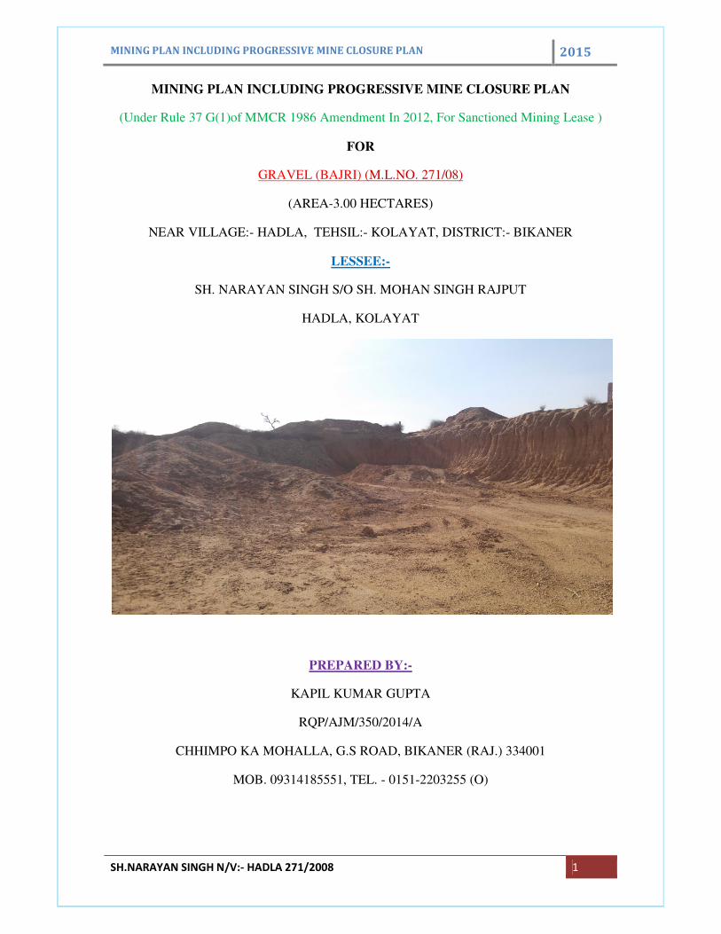
GRAVEL (BAJRI) (M.L.NO. 271/08)
(AREA-3.00 HECTARES)
NEAR VILLAGE:- HADLA, TEHSIL:- KOLAYAT, DISTRICT:- BIKANER
LESSEE:-
SH. NARAYAN SINGH S/O SH. MOHAN SINGH RAJPUT
HADLA, KOLAYAT
PREPARED BY:-
KAPIL KUMAR GUPTA
RQP/AJM/350/2014/A
CHHIMPO KA MOHALLA, G.S ROAD, BIKANER (RAJ.) 334001
MOB. 09314185551, TEL. - 0151-2203255 (O)
MINING PLAN INCLUDING PROGRESSIVE MINE CLOSURE PLAN 2015
SH.NARAYAN SINGH N/V:- HADLA 271/2008 2
INDEX
S.NO. DESCRIPTION PAGE NO.
1. GENERAL
2. LOCATION AND ACCESSIBILITY
3. GEOLOGY AND EXPLORATION
4. MINING
5. BLASTING
6. MINE DRAINAGE
7. STACKING OF MINERAL REJECTS AND DISPOSAL OF WASTE
8. USE OF MINERAL
9. OTHERS
10. MINERAL BENEFICITION
11. ENVIRONMENT MANAGEMENT PLAN
12. ANY OTHER INFORMATION
13. PROGRESSIVE MINE CLOSURE PLAN
LIST OF PLATES
S.NO. PARTICULARS PLATE NO. SCALE
1. LEASE AREA MAP 1 1:4000
2. KEY PLAN 2 1:50000
3. SURFACE PLAN 3 1:2000
4. SURFACE GEOLOGICAL PLAN AND
SECTIONS
4 1:2000
5. YEAR WISE WORKING PLAN AND
SECTIONS
5 1:2000
6. ENVIRONMENT PLAN 6 1:5000
7. CONCEPTUAL PLAN 7 1:2000
8. PROGRESSIVE MINE CLOSURE PLAN 8 1:2000
LIST OF ANNEXURES
S.NO. PERTICULARS ANNEXURE NO.
1. PHOTO COPY OF SANCTION LETTER I
2. PHOTO COPY OF RQP CERTIFICATE II
3. PHOTO COPY OF DEMARCATION REPORT III
4. PHOTO COPY OF KHASARA MAP & JAMABANDI IV
MINING PLAN INCLUDING PROGRESSIVE MINE CLOSURE PLAN 2015
SH.NARAYAN SINGH N/V:- HADLA 271/2008 3
CRETIFICATE
I hereby authorize Shri Kapil Kumar Gupta, RQP to prepare mining plan
including progressive mine closure plan in respect of GRAVEL (BAJRI) N/V
hadla, Tehsil- Kolayat District – Bikaner, State – Rajasthan, over an area of 3.00
HECTS. The above mining plan has been prepared on my consent & approval
and that I will abide by all the commitments made under. In case of default,
approval of mining plan may be withdrawn.
Date:
Place: Signature of the applicant
DECLARATION
The mining plan including progressive mine closure plan has been prepared in
full consultation with me & I understood its contents & agree implement the
same in accordance with the law.
Date:
Place: Signature of the applicant
MINING PLAN INCLUDING PROGRESSIVE MINE CLOSURE PLAN 2015
SH.NARAYAN SINGH N/V:- HADLA 271/2008 4
CERTIFICATES
(1) This is to certify that the provision of mineral conservation and
development rules, 1988 have been observed in the preparation of mining plan
of Gravel (Bajri) area for an area of 3.00 HECTS. N/V hadla, Tehsil Kolayat,
District – Bikaner, State – Rajasthan by Sh. Narayan Singh (M.L.NO. 271/2008).
Wherever specific permission is required, the applicant will approach the
concerned Authorities for granting the permission.
(2) Certified that the provision of mines Act. Rules & Regulations made there
under have been observed in preparing this mining plan and wherever specific
permission is required, the applicant will approach the D.G.M.S.
(3) It is also certified that the information furnished in the above mining plan
true and correct to the best my knowledge.
Date: (Kapil Kumar Gupta)
Place: Bikaner RQP/AJM/350/2014/A
MINING PLAN INCLUDING PROGRESSIVE MINE CLOSURE PLAN 2015
SH.NARAYAN SINGH N/V:- HADLA 271/2008 5
1. GENERAL
(a) Name of Applicant & Complete Address:
Sh. Narayan Singh S/o Sh. Mohan Singh Rajput
Village Hadla, Kolayat
(b) Status of Applicant:
Individual
(c) Minerals Which Are Occurring In The Area And Which The Applicant
Intends To Mine:
GRAVEL (BAJRI)
(d) Period for Which the Mining Lease Is Granted/Renewed/Lease:
The mining lease is already sanctioned mining lease area for a period of
thirty years, with effect from date of registration. Photo copy of consent
letter is enclosed as Annexure I
(e) Name of RQP Preparing the Mining Plan with Registration No.:
Kapil Kumar Gupta
Address- Chhimpo Ka Mohalla, G.S Road, Bikaner.
Reg. no-RQP/AJM/350/2014/A
CERTIFICATE IS ENCLOSED AS ANNEXURE –II
(f) Name of prospecting agency:
No prospecting works done by any agency. The mineral bajri is available at
the depth of 1-2 mt so there is no requirement of such specific prospecting.
(g) Reference No and date of consent Letter from the state Government:
This mining plan is prepared by order of state govt. under rule 37G(1)
MMCR 1986 for sanctioned lease area and progressive mine closure plan
under 37E MMCR 1986 amended in 2012.
MINING PLAN INCLUDING PROGRESSIVE MINE CLOSURE PLAN 2015
SH.NARAYAN SINGH N/V:- HADLA 271/2008 6
2. LOCATION AND ACCESSIBILITY
(a) Details of area (with location map): key plan as plate no-2
District & State: Bikaner and Rajasthan
N/V: Hadla
Tehsil: Kolayat
Khasra no-45, 46
Lease area: 3.00 HECTS.
Whether the area is recorded to be in forest (please specify, whether
protected, reserve etc.): No area does not fall in forest land.
Ownership Occupancy: Government waste land – Nil hect.
Private land -Nil.=3.00 hect
Toposheet No. with latitude & longitude Of FRP: The mining lease area falls
in Survey of India Toposheet No.45 E/1.
Existence of public road/railway if any nearby and approximate distance
the mining lease area situated 10 km. south east to village Kolayat. The
mining lease area is assessable by National Highway No. 15 and is located
about 40 km. from Bikaner District Headquarter. Other facilities like Medical,
Telephone, Telegraph is available at Hadla.
(b) Attach a general location and vicinity map showing are boundaries and
existing and proposed access routes. It is referred that the area be marked
on the survey of India topographical map or a cadastral map or forest map
as the case may be. The key plan is prepared by the Toposheet no. 45 E/1 on
a scale of 1:50000.
Key plan (plate no. 2) showing the location of the area is enclosed.
MINING PLAN INCLUDING PROGRESSIVE MINE CLOSURE PLAN 2015
SH.NARAYAN SINGH N/V:- HADLA 271/2008 7
3.0 GEOLOGY AND EXPLORATION
(A) Physiography & Geology:
The lease area is showing almost flat topography. The highest assumed
contour is 100 mts. in the lease area while lowest contour is 95.00 mts. in the
lease area. This provides an elevation difference of 1.0 mtr. the general slope
of the area is towards south west direction. Most of the lease area is covered
with Alluvium Sand. There is no seasonal nalla flowing through lease area. The
land status of lease area is Private land.
The contours and other features are marked in the surface plan and surface
geological plan plate no.3 & plate no.4 respectively. These plans are prepared
on a scale of 1cm.=20mt.
Geology
The regional and general of the area has been referred from an article of Sri
R.N.GHOSH, G.S.I. this article was published in India mineral 1983. The
geological map of the Kolayat area is also from this article Mr. R.N. GHOSH,
during his investigation of the area in 1969-70 noted an extensive nature of
occurrence of these sedimentary clays in Kolayat Region.
The stratigraphic sequence is given below:-
Recent Alluvium & Aeolian sand, sandy calcareous grit, kanker iron
nodules, ferruginous bands and recent conglomerate.
-------------------------------Unconformity--------------------------------
Upper foraminiferous-ferruginous lime stone. White clay mudh.
Dirty brown to dark impure limestone with broken shells of
ostrea.
Eocene age: (Calcareous facies/formation, fuller’s earth
association)
Upper horizon of fullers earth containing gray to grayish yellow &
reddish fuller’s earth wills shale’s & shaly limestone partings.
Lower, horizons of fuller’s earth containing a thin bed of gray
yellow green fuller’s earth.
Lower foraminiferal limestone.
White fossiliferous marl with intercalation yellow ochraceous
shale impure white clayey limestone & yellow calcareous
MINING PLAN INCLUDING PROGRESSIVE MINE CLOSURE PLAN 2015
SH.NARAYAN SINGH N/V:- HADLA 271/2008 8
siltstone.
------------------------------ Unconformity----------------------------------
Upper, cretaceous to lower Paleocene (argillaceous
facies/formation clay)
Ferruginous bands
Ferruginous gritty saccharoidal sandstone with glass sand &
white siltstone with several interbedded beds of white clay.
Local Geology:
The area under consideration falls under Tertiary formation. Lease area is
covered by the murrum and no rock exposure is seen on the surface.
Geological, recent to sub-recent formation having blown sand, pebbly grit and
clay beds are found.
Litho units exposed on the surface in the lease area:
Given below is the generalized litho-unites exposed on the surface of the lease
area:
1. Alluvium Sand
2. Gravel with sand
Mode of occurrence:
The Gravel (bajri) Kankar in general is intercalated with localized mixture of
alteration of alluvium sand. The quality of Gravel (bajri) Kankar in term of grain
size, strength show the sigh of improvement in depth. The manual sorting and
dressing will be required to separate Kankar for enhancing the commercial
value of Gravel.
(B) Exploration Work Done To Date:
Investigation or scientific studies were undertaken in this area; however
surface topographical survey, geological study including mapping of lease area
was carried out during the preparation of this mining plan.
(C) Preparation & Submission of Geological Section on Suitable Scale:
The geological plan and sections are prepared on the scale R.F. 1:2000
enclosed as plate no.4.
MINING PLAN INCLUDING PROGRESSIVE MINE CLOSURE PLAN 2015
SH.NARAYAN SINGH N/V:- HADLA 271/2008 9
(D) Synthesis of Exploration:
At present there is one working pit in lease area and some tube wells present
nearby the lease area, on that base we confirming that GRAVEL (BAJRI) is the
only mineral present in the lease area. The deposit is a sedimentary origin
bedded deposit.
(E) Exploration Proposed To Be Carried Out In The First Five Years:
In order to confirm the present GRAVEL (BAJRI) bed in the promising area
particular in the probable and possible category reserves area, certain amount
of pitting considered necessary to delineate depth, grade and attitude of the
GRAVEL (BAJRI) bed.
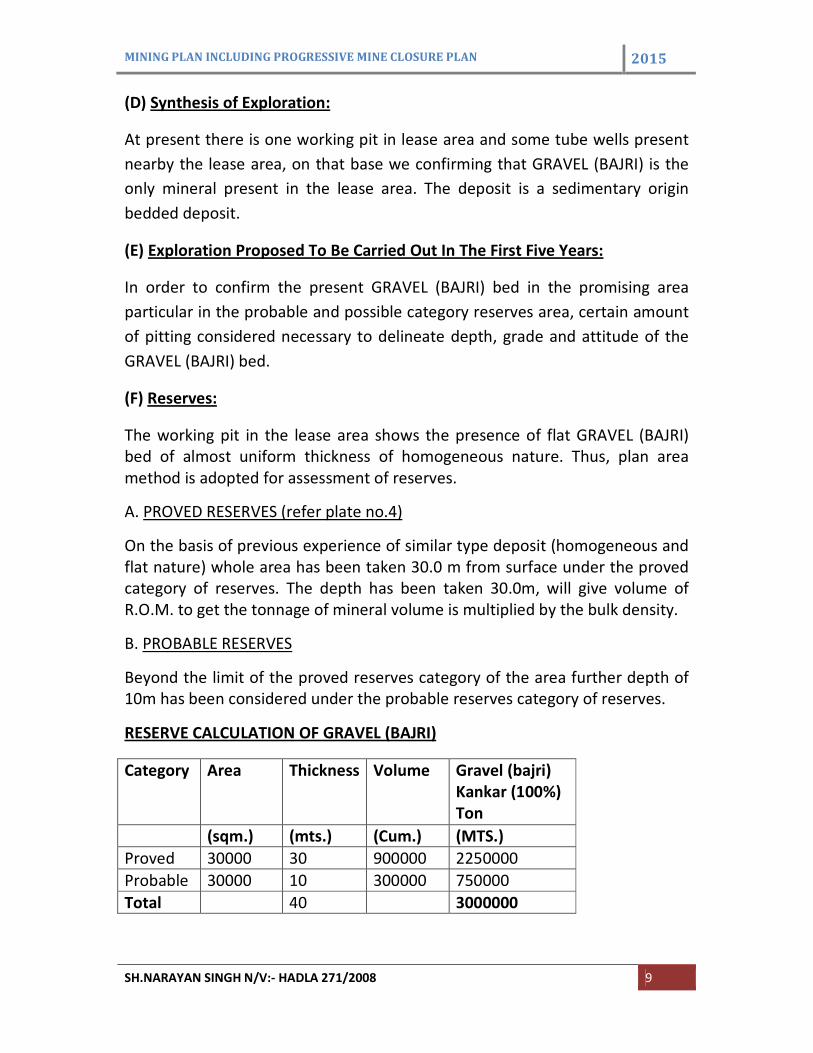
(F) Reserves:
The working pit in the lease area shows the presence of flat GRAVEL (BAJRI)
bed of almost uniform thickness of homogeneous nature. Thus, plan area
method is adopted for assessment of reserves.
A. PROVED RESERVES (refer plate no.4)
On the basis of previous experience of similar type deposit (homogeneous and
flat nature) whole area has been taken 30.0 m from surface under the proved
category of reserves. The depth has been taken 30.0m, will give volume of
R.O.M. to get the tonnage of mineral volume is multiplied by the bulk density.
B. PROBABLE RESERVES
Beyond the limit of the proved reserves category of the area further depth of
10m has been considered under the probable reserves category of reserves.
RESERVE CALCULATION OF GRAVEL (BAJRI)
Category Area Thickness Volume Gravel (bajri)
Kankar (100%)
Ton
(sqm.) (mts.) (Cum.) (MTS.)
Proved 30000 30 900000 2250000
Probable 30000 10 300000 750000
Total 40 3000000
MINING PLAN INCLUDING PROGRESSIVE MINE CLOSURE PLAN 2015
SH.NARAYAN SINGH N/V:- HADLA 271/2008 10
Mineable reserves
Safety zone have about 5365 sqmt and around 536500 tonnes mineral will be
deduct in reserve Thus, the total mineable reserve = 3000000
3000000-536500=2463500 tonnes
4.0 MINING
Proposed Mining Method:-
The Gravel (bajri) Kankar bed is overlain by Kankar (murrum), so to extract
Gravel (bajri) Kankar it becomes necessary to remove the overburden. Since
the deposit occurs at a depth of 1-1.5 mts and the thickness of the deposit is
sufficient to be economically mineable. Semi mechanized open cast Manual
mining is the suitable method for mining. The mining will be done as per
requirement. The height of the benches will be kept 3.0 mt in overburden and
5.0 mt in mineral. The overburden and mineral will be excavated mechanically.
Occassionally overburden will be removed with the help of JCB on hire basis.
Transportation of Gravel (bajri) Kankar from face to pit top will also be made
machine where as waste will be directly loaded in to trucks for disposing off to
waste dump yard temporarily. The overburden is unconsolidated and alluvium
sand and kankar (murrum). The mineralized Gravel (bajri) Kankar bed is
basically soft and easily extractable by earth movers. In view the above drilling
and blasting of rock would not be required.
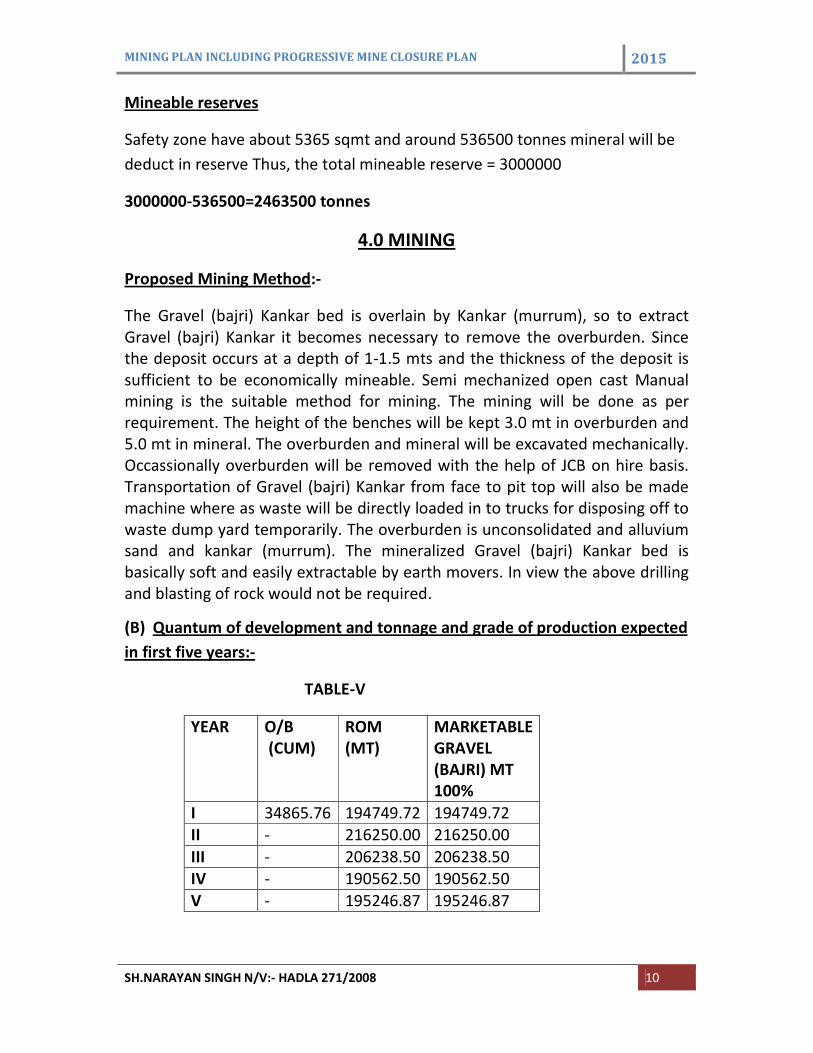
(B) Quantum of development and tonnage and grade of production expected
in first five years:-
TABLE-V
YEAR O/B
(CUM)
ROM
(MT)
MARKETABLE
GRAVEL
(BAJRI) MT
100%
I 34865.76 194749.72 194749.72
II - 216250.00 216250.00
III - 206238.50 206238.50
IV - 190562.50 190562.50
V - 195246.87 195246.87
MINING PLAN INCLUDING PROGRESSIVE MINE CLOSURE PLAN 2015
SH.NARAYAN SINGH N/V:- HADLA 271/2008 11
(C) Attach Composite Plan, And Year Wise Section:-
The plan and sections showing the pit positions in first five years are prepared
at scale 1:2000 . (Refer-Plate no-5).
(d) Attach plan showing pit layouts, dumps, mineral reject stack, etc:
Year wise working plan exhibits pit layouts, waste dumps, mineral stack etc.
(refer –plate no-5)
(e) Proposed Rate Of Production And Life Of Mine:-
The average yearly production of ROM based on proposed production=200000
Tonnes, The mineable reserves of the lease area== 2463500 tonnes
Life of mine =12.31 years or says 12 years.
(f) Conceptual Mining Plan for the Lease Period:-
(1) Exploration:-Proposed exploration for the next five years is not required
because there is already working pit in the lease area so there is no
requirement of exploration.
(2) Quantity of waste expected during lease period:- Now as describe earlier
mineral recovery is taken 100% so there will be no reject. At the end of lease
period about 24635 cum OB will be generate.
(3) Space:- The OB will be used for development in plantation at the end of
lease period.
(4) Reclamation: - There is no proposal for reclamation of worked out area
during the mining plan period. The OB will be dumped in to the safty zone
area. Total excavated area will be converted as a water reservoir which will
help in recharging the water table of nearby area and the water accumulated
in the reservoir can also be utilized for drinking, plantation as well as
agriculture purpose of the nearby villagers.
(5) Plantation:- Total 0.99 hect area will be covered for plantation in lease area
and about 0.4535 hect area will be developed for plantation outside the lease
area up to end of the lease period .
The position at the end of lease period is shown in plate no. 7 conceptual plan.
MINING PLAN INCLUDING PROGRESSIVE MINE CLOSURE PLAN 2015
SH.NARAYAN SINGH N/V:- HADLA 271/2008 12
(6) Opencast Mines:-
(i) Salient Features of Mode of Working: -
Overburden (1.0mt) compel to engage JCB (Occasionally deployed) for
maintaining systematic benches and development well ahead to facilitate
smooth production of GRAVEL (BAJRI), Kankar which is proposed to be carried
out by earth movers equipments.
First year Development & Production:
In the first year of mining will be done by extending the working pit in North
and South direction. One bench will be developed in the overburden at RL 100
to 98.0 mts. Advancing towards North and South directions. Total 34865.76
cum overburden will be removed in the first year of the mining plan.
After developing this bench Two another bench will be developed in the
GRAVEL (BAJRI), bed at the RL 98.00mts. To 95.00mts and RL 95.00 To 90.00
mts. Advancing towards North and South directions. Total ROM Production
Will Be 194749.72 tonnes Marketable GRAVEL (BAJRI) 194749.72 tonnes will
be produced in the first year of mining plan. The calculations are tabulated in
table no. VI (Refer –plate no. 5 proposed year wise development plan).
Second year Development & Production:
In the second year of mining will be done by extending the working pit in north
South direction.No bench will be overburden in the second year. one bench
will be developed in the GRAVEL (BAJRI), bed at the RL 95.00 to 90.00mt
advancing towards north and South directions. Total ROM Production Will Be
216250 tonnes Marketable GRAVEL (BAJRI) 216250 tonnes will be produced in
the Second year of mining plan. The calculations are tabulated in table no. VI
(Refer –plate no. 5 proposed year wise development plan).
Third year Development & Production: In the Third year of mining will be
done by extending the working pit in north South direction. No bench will be
developed in the overburden in the Third year of the mining plan.
In the third year of mining will be done by extending the working pit in north
South direction. Developed in the GRAVEL (BAJRI) bed at the RL 90.00mts. to
85.00mts. advancing towards North & South directions. Total ROM Production
MINING PLAN INCLUDING PROGRESSIVE MINE CLOSURE PLAN 2015
SH.NARAYAN SINGH N/V:- HADLA 271/2008 13
Will Be 206238.5 tonnes Marketable GRAVEL (BAJRI) 206238.5 tonnes will be
produced in the Third year of mining plan. The calculations are tabulated in
table no. VI (Refer –plate no. 5 proposed year wise development plan).
Fourth year Development & Production:
In the fourth year of mining will be done by extending the working pit in north
South direction. Developed in the GRAVEL (BAJRI) bed at the RL 90.00mts. to
85.00mts and 85.00mts to 80.00. Total ROM Production Will Be 190562.5
tonnes Marketable GRAVEL (BAJRI) 190562.5 tonnes will be produced in the
first year of mining plan. The calculations are tabulated in table no. VI (Refer –
plate no. 5 proposed year wise development plan).
Fifth year Development & Production: In the Fifth year of mining will be done
by extending the working pit in north South direction. In the fifth year of
mining will be done by extending the working pit in north South direction.
Developed in the GRAVEL (BAJRI), bed at the RL 85.00mts. To 80.00mts and
80.00mt ot 75.00mts advancing towards North South direction. Total ROM
Production Will Be 195245.87 Tonnes Marketable GRAVEL (BAJRI) 195245.87
Tonnes will be produced in the Fifth year of mining plan. The calculations are
tabulated in table no. VI (Refer –plate no. 5 proposed year wise development
plan).
MINING PLAN INCLUDING PROGRESSIVE MINE CLOSURE PLAN 2015
SH.NARAYAN SINGH N/V:- HADLA 271/2008 14
Year wise production of mineral and waste (Refer plate no.5)
Year BENCH R.L. AREA
(mts.)
AVG.THIC
K
NESS
(Mts.)
VOLUME
(Cum.)
Bulk
density
MINERAL
(Ton.)
Market
Able
GRAVEL (BAJRI)
(100%)
(Ton)
Overburden
(CUM)
from To
I. I. 100 98.0 17432.8 2 34865.76 34865.76
II. 98.0 95.0 17761.8 3 53285.64 2.5 133214.10 133214.10
III. 95.0 90.0 4922.85 5 24614.25 2.5 61535.62 61535.62
Total 194749.1 194749.1 34865.76
II. I. 95.0 90.0 17300.31 5 86500 2.5 216250 216250
Total 216250 216250
III. I. 90 85 16499.08 5 82495.4 2.5 206238.5 206238.5
Total 206238.5 206238.5
IV. I. 90 85 6382 5 31910 2.5 79775 79775
II. 85 80 8863 5 44315 2.5 110787.5 110787.5
Total 190568.5 190568.5
V. I. 85 80 11166.75 5 55833.75 2.5 139584.37 139584.37
II. 80 75 4453 5 22265 2.5 55662.5 55662.5
Total 195246.87 195246.87
MINING PLAN INCLUDING PROGRESSIVE MINE CLOSURE PLAN 2015
SH.NARAYAN SINGH N/V:- HADLA 271/2008 15
(h) Underground mines:-
Not applicable
(I) Extent of Mechanization:-
The excavation is done with help of earth movers. Excavated material contains
maximum part of gravel (Bajri) and the material will be stacked with help of
haulage machineries and marketed directly.
(i) Loading Equipment
For loading of mineral m/c will be used.
(ii) Haulage and Transport Equipment
(a) Haulage within the mining leasehold: Transportation of GRAVEL (BAJRI),
kankar from face to pit top will also be made manually where as waste will be
directly loaded in to trucks for disposing off to waste dump yard temporarily.
(b) Transport from mine ahead to the destination: Transport from mine head
to destination will be done by the trucks on hire basis.
(iii) Miscellaneous
No allied operation requires machinery.
5. BLASTING
The overburden is unconsolidated soil, sand material and Kankar(murrum). The
mineralized Gravel (Bajri), Kankar bed is basically soft and mining will be done
with the help of earth movers equipments. The mining is running by skilled
labours and there is no requirement of blasting for such type of mining.
6. MINE DRAINAGE
The lease area showing almost flat topography. There is no nalla in lease area
so there is no effect on surface water.
The proposed mining in the next five years is only up to 25mt depth from the
surface level. In the rainy season almost all the water will flow on the
surrounding agriculture land and government land and no water will be
accumulated in the working area. Ground water table is 100 to 110 mt deep
from the surface level so the ground water will not hinder the working.
MINING PLAN INCLUDING PROGRESSIVE MINE CLOSURE PLAN 2015
SH.NARAYAN SINGH N/V:- HADLA 271/2008 16
7. STACKING OF MINERAL REJECTS AND DISPOSAL OF WASTE
(A) Nature and quantity of topsoil, overburden, and mineral rejects likely to
be generated during the first five years:-
During the five years of working the nature of waste would consist of Sand and
kankar (murrum).
Overburden:-Sand and kankar (murrum), Pebbles and moist in nature, is
occurred overburden.
The O.B /waste and reject are generated during the five years period of the
mining plan are given as below:-
Table-VII
Year O.B. (Cum)
I 34865.76
II -
III -
IV -
V -
Total 34865.76
(B) Land chosen for disposal of O.B. /reject with justification:-
The O.B. material will be generated during the period of the mining plan will
be dumped in safety zone area for developing in plantation as shown in the
proposed working plan.
(C) Maximum height and spread of dumps:-
No waste will be generated during the period of the mining plan.
(D) Selection of site and spread for stacking of mineral reject:-
All material are saleable so there is no requirement of stacking of Rejects.
MINING PLAN INCLUDING PROGRESSIVE MINE CLOSURE PLAN 2015
SH.NARAYAN SINGH N/V:- HADLA 271/2008 17
8. USE OF MINERAL
The mineral produced from this mine will be used mainly as building
construction material. Bajri gravel is significant building construction material
and well known for its compactness and bonding nature which gives strength
to cementing materials of building construction.
MINING PLAN INCLUDING PROGRESSIVE MINE CLOSURE PLAN 2015
SH.NARAYAN SINGH N/V:- HADLA 271/2008 18
9. OTHER
(a) Site services:-
1. Office and store: - An office –cum-store will be constructed in mining
lease area as shown proposed year wise development plan plate no-5.
2. Water supply:- The water is required for drinking purpose only drinking
water is available by the water tanks in the lease area.
3. Power supply:- Electric line is passing through the lease area so lessee
will be taken connection from this line wherever required.
4. Workshop:- As already stated the mining is semi mechanized and
occasionally engagement of JCB is on hire basis and, therefore, no proposal is
given at this point.
5. First-aid facility:-A first aid box with all necessary materials will kept all
the times in the office building for use as and when required.
(b) Employment Potential:-
Because of small-scale mining proposals, depending on the requirement of
mining work and also as per statutory requirement of acts and rules sufficient
supervisory, skilled and unskilled person will be employed at the mine to run
systematically and safely. The employment potentials of the mine is given
below:-
Management and Supervisory staff
S .NO. CATEGORY QUAILIFICATION REQUIREMENT
1. MINING
ENGINEER
B.E (MINING) ONE (PART TIME)
2. MINING MATE CERTIFICATE
HOLDER
ONE
3. TIME KEEPER 12th
PASSED ONE
4. CHOWKIDAR 10th
PASSED ONE
MINING PLAN INCLUDING PROGRESSIVE MINE CLOSURE PLAN 2015
SH.NARAYAN SINGH N/V:- HADLA 271/2008 19
Labour Requirement
Target production-200000
Working days in a year-300
No of shift in a day-2
Per day output required in mineral-666.66 tonnes
O.M.S observed in near areas-3 ton
Labour required per day in the mineral will be 10 Nos.
Labour required per day in overburden will be 5 Nos.
For miscellaneous jobs one labour will be require.
Total labour =10+5+1=16
All labour will be of unskilled category.
10. MINERAL BENIFICIATION
No mineral beneficiation processing of any kind will be undertaken at mines
except development of proper shape and size.
MINING PLAN INCLUDING PROGRESSIVE MINE CLOSURE PLAN 2015
SH.NARAYAN SINGH N/V:- HADLA 271/2008 20
11.0 ENVIRONMENT MANAGEMENT PLAN
A. Note on the status of Baseline Information:-
1. Existing Land Use Pattern”
S.no Forest
Land
Crop
land
Grazing
land
Waste
land
Others Total Indicate
land
req.
outside
lease
area
(a) Pits and
Quarries
- - - 0.6800 - 0.6800 -
(b) Dumps of
Ore, waste &
O.B
- - - - -
(c) Infrastructure
including of
office
Workshop &
plants road
- - - 0.0030 - 0.0030 -
(d) Plantation - - - 0.0250 - 0.0250 -
(e) Others - - - 2.297 - 2.297 -
(f) Barren land - - - - - - -
(g) Crop land - - - - -
Total
occupied area
- - - 3.00 - 3.00 -
(f) Area backfield mine owner- Nil
(g) Area afforested by mine owner- Nil
(2) Water Regime:-
In the rainy season almost all the water will flow on the surrounding land and
no water will be accumulated in the working. Ground water table is 100 to 110
MINING PLAN INCLUDING PROGRESSIVE MINE CLOSURE PLAN 2015
SH.NARAYAN SINGH N/V:- HADLA 271/2008 21
mts deep from the surface level so the ground water will not hinder the
working.
(3) Flora and Fauna:-
The area in 5.0 kms radius from lease area does have some vegetation but it is
not much significance. There is no reserve or protect forest. Some vegetation is
there in part of the remaining area near villages and farms in which density of
plants range from 4-5 plants /hectares. Common species of flora found in this
region are given under:-
1 Khejri (Procopius Cineraria)
2 Babool (Acacia Nilotika)
3 Neem (Azadiracta Indica)
4 Grass (Lasiurus Sindicus)
No carnivorous animals are seen in around 5.0km radius because there is no
wild life of games sanctuary is observed. Some time Rabbit (Oryctolagus
cuniculas), Dog (Canis lupes familiaris), Deer (Cervus axis), Jackal (Canis
aureus), or Foxes (Vulpes zerda) are seen occasionally. Pet animals like cow,
goat, and sheep etc animals are framed by local villagers.
4. Quality Of Air, Ambient Noise level and Water;-
Quality of Air:
The air is free from any pollution, as there is no industry or any other source of
air pollution present in the vicinity of the area. The quality air is good. Some
amount of dust will be in the lease area due to movement of trucks/tractors
and also dusts emission in the air during the mining with the conventional tools
like picks, crowbar and hammers and at the time of overburden removal by
JCB.
Noise:
MINING PLAN INCLUDING PROGRESSIVE MINE CLOSURE PLAN 2015
SH.NARAYAN SINGH N/V:- HADLA 271/2008 22
As already stated the mining is semi mechanized so the noise will be
generated. Lessee will provide ear muff to the workers and labours and will be
kept good maintenance of vehicles.
Water quality:
Since there is no surface water in the area therefore is no need of assessment
of quality of surface water. Underground water percolating water exists in the
region as seen in the wells near about. The depth of water table in bed varies
from 100 to 110mts during the year so the ground water will not hinder the
working. However, fluctuations of water table depend greatly on the strong
and weak monsoon. Underground water in the region is tapped by a dug wells
in nearby areas. There are no toxic substances and there is no danger or
recharging of water table with toxic substances.
In wells generally good quality and quantity of water for domestic purpose is
always available in summer month. Though small in quantity but water
available is fresh and is potable.
5. Climatic Conditions:
The area is a part of the Thar Desert (arid zone) and characterized by its
tropical semi arid climatic conditions. It is also characterized by scanty erratic
rain fall, high evaporation and extreme heat and cold. The area experience
wide seasonal variation in maximum and minimum temperatures. During
summer the heat is oppressive and day temperature exceeding 430 C are
common during the month of May and June.
The dust storms are usual features in the area. The hot winds blow with great
furry during the month of May, June and part of July. A large quantity of sand
gets shifted due to strong wind charging the atmosphere with sand particles.
The wind speed ranges from 13-40km/hour. During winter (nov. to feb.) the
winds are north-westerly and also northerly where as in the monsoon the
winds are southerly to south-westerly. The temperature in the winter season
falls to 1-20 c and occasionally below the freezing point (0
0c). the maximum
temperature recorded is 49.40c in may and the lowest 0
0c in January. Due to
arid conditions and lack of vegetation, there is a rapid radiation with an annual
being 85% and 6% during day and night respectively. Rainfall is scanty around
25.5cms in a year. most of the rain occurs during july to September. Due to
poor rain fall and as a result of scanty precipitation, the water table conditions
are at a considerable (80 to 130mtr).
MINING PLAN INCLUDING PROGRESSIVE MINE CLOSURE PLAN 2015
SH.NARAYAN SINGH N/V:- HADLA 271/2008 23
(6) HUMAN SETTLEMENT:
The human settlement within 5.0km from the area is given below. Agriculture
is the main profession of that area. The per capita income of that area is
around Rs 20,000b per annum.
S.N VILLAGE DISTANCE POPULATION
1. Hadla 2.5km 15000
(7) Public building, places and monuments:
There is no important public building places monument with in 5.0kms radius
of lease area. There is no national park and wild life sanctuary near the lease
area.
(8) Agriculture:
All lease area is pvt land.
(9) Whether area falls under notified area under water (prevention & control
of pollution) act, 1974: -
The area is not notified under water act, 1974.
(B) Environmental Impact Assessment:
1) Land Environment
(i) Land use pattern after fifth year:
Forest
land
Crop
land
Grazing
land (in
hectare.)
Waste
land
Other Total Indicate land
outside area
(a)pits &
Quarries
- - - 2.4635 - 2.4635 -
(b) Dumps of
Ore waste & O.b.
- - - - - - -
(c) Infrastructure
Including of office
Workshop & plants
road
- - - 0.0030 - 0.0030 -
(d) Plantation - - - 0.5000 - 0.5000 -
(e) Other - - - 0.0335 - 0.0335 -
(i) Barren land - - - - - - -
MINING PLAN INCLUDING PROGRESSIVE MINE CLOSURE PLAN 2015
SH.NARAYAN SINGH N/V:- HADLA 271/2008 24
(ii) Crop land - - - - - - -
Total occupied
area
- - - 3.0 - 3.0 -
(ii) Aesthetic environment:
The aesthetic environment of the area will not have any adverse effect. The
proposed mining is on that place, where no vegetation is present. Hence there
will be no impact on the aesthetic environment of the area.
(iii) Soil and land use pattern:
Where 5 year working is proposed there is presence of soil so there is
requirement of stacking top soil at appropriate place. It will be used for
development in plantation.
(iv) Agriculture:
All lease area falls in Pvt. waste land hence no effect on the agriculture works.
(v) Forest:
No forest land is in or near by the lease area.
(vi) Vegetation:
Where five year working is proposed there is no vegetation present hence on
effect on the vegetation during 5 year working of the mining plan.
(vii) Public building, places and monument:
There is on important public building places and monument with in 5.0kms
radius of lease area. There is no national park and wild life sanctuary near the
lease area. Hence no effect on them.
(2) Water Environment
(i) Surface water
MINING PLAN INCLUDING PROGRESSIVE MINE CLOSURE PLAN 2015
SH.NARAYAN SINGH N/V:- HADLA 271/2008 25
There is no nalla passing through the lease area hence there will be no effect
on surface water.
(ii) Ground water
The ground water is 100-110mts below the surface level. The mining
operation will be on higher level above the water table, therefore there may
not be significant impact.
(iii) Quality of water
The will be no impact of mining on quality of water by any of the mining
operation as on water from other source is getting mixed with rainwater.
(3) Air Environment
(i) Noise
The proposed mining is semi mechanized opencast method but some amount
of noise will be due to JCB to be deployed occasionally on hire basis for
removal of overburden and movement of truck & tractor. To avoid this proper
maintenance of the m/c will be done and the earplugs will be provided to the
operators.
(ii) Air
The mining will be done with help of conventional tools and occasionally small
excavator to be used for removal of overburden and mineral and movement of
tractors/trucks, there will be the generation of dust in Air. The amount of dust
generated will be vey less, which within permissible limits. Dust mask will be
provided to the operators/workers. Water will be sprayed at roads if dust
generated more.
(iii) Climatic conditions
There will be no impact on climatic conditions of the area by mining
operations.
(4) socio-economic Environment
MINING PLAN INCLUDING PROGRESSIVE MINE CLOSURE PLAN 2015
SH.NARAYAN SINGH N/V:- HADLA 271/2008 26
(i) Socio and demographic profile
Mining in remote and rural areas brings in some changes in the traditional life
style of the local people. The mining in the area will be generated employment
potential and general financial status and socio-economic of few laborers will
be improved. Most of the people are poor and marginal farmers. Due to lake of
proper agriculture mostly they are from labor class. Due to mining activity they
will get job adjacent to their villages.
(ii) Occupational health and safety
Systematic and safe mining, there will be no impact on health and safety of the
workers and human settlements in and near by the area.
(iii) Human settlement
By systematic and safe mining, there will be no impact on health and safety of
the workers but some may affected by mining.
(iv) Recreational facility
Presently no recreational facilities are present in and around the area.
Therefore there will be no impact on these.
(C) Environmental Management Plan (Enclosed as Plate No.6):
(1) Temporary storage and utilization of topsoil
It is already sanctioned area so there is a working pit in mining lease area but
some part of lease area is covered by Alluvium sand.
(2) Proposal for reclamation of land affected by mining activities
during and at the end of mining lease period:
There is no proposal for reclamation of worked out area during the mining plan
period because there is possibility of another layer of mineral.
Some part of the area will be made as water reservoir, which will help in
recharging the water table of nearby area and the water accumulated in the
reservoir can also be utilized for drinking, plantation as well as agriculture
purpose of the nearby villagers.
MINING PLAN INCLUDING PROGRESSIVE MINE CLOSURE PLAN 2015
SH.NARAYAN SINGH N/V:- HADLA 271/2008 27
(3) Programme of afforestation”
To improve the aesthetic environment of the area it is proposed to plant 200
trees yearly inside the safety zone area. During the first five years sapling of
local species like Babool, Neem, Rohida etc will be planted over an area of
5000 sqm shown in the proposed working plan, plate no 5 & Environment plan
plate no. 6 year wise details of plantation are given below:
Year No. Replacement
(60%)
Type of
species
Location
I 40 24 Babool, Neem As shown in working plan, plate
no.5
II 40 24 “
III 40 24 “
IV 40 24 “
V 40 24 “
(4) Stabilization and Vegetation of Dumps
Waste dump consists of Sand & Kankar temporarily stacks in mining lease area.
The retaining wall will also be provided to the lower side of the waste dump to
avoid the spreads of the waste material if required.
(5) Treatment and Disposal of Mine Water:
There will be no make of water during any of the mining operations; therefore
there will be no need of treatment and disposal of mine water.
(6) Measures for minimizing adverse effect on water regime:
There is no significant adverse effect on water regime. However, as measures
monitoring of water quality by analyzing will be made. In this regard base line
information on water is established.
(7) Socio- Economic Benefits arising out of mining:
There are few mines in the vicinity of this area looking to unemployment the
people go outside for earning their livelihood. This mine will provide directly
opportunity of additional employment near their homes. Thus earning of the
people will increase and will help upliftment of socio-economic status of the
employees.
(8) Measures for dust control:
MINING PLAN INCLUDING PROGRESSIVE MINE CLOSURE PLAN 2015
SH.NARAYAN SINGH N/V:- HADLA 271/2008 28
Because of occasionally JCB to be used for removal of overburden
and movement of tractors/trucks there will be the generation of dust. The
amount of dust generated will be very less because grit & kankar (murrum).
Dust mask will be provided to the operators/Workers. Water will be sprayed at
roads.
(12) ANY OTHER INFORMATION: Nil
Signature of applicant Prepared By
Sh. Narayan Singh Kapil Kumar Gupta
RQP/AJM/350/2014/A
MINING PLAN INCLUDING PROGRESSIVE MINE CLOSURE PLAN 2015
SH.NARAYAN SINGH N/V:- HADLA 271/2008 29
CERTIFICATES
This progressive mine closure plan complies all statutory rule, regulations,
orders made by the central Government, State Government, Statutory
Organizations, Court etc. have been taken in to consideration and whereas any
specific permission is required the applicant will approach the concerned
authorities.
Applicant
UNDERTAKING
I Sh. Narayan Singh undertakes that all the measures proposed in this closure
plan will be implemented in a time bound manner as proposed.
Applicant
MINING PLAN INCLUDING PROGRESSIVE MINE CLOSURE PLAN 2015
SH.NARAYAN SINGH N/V:- HADLA 271/2008 30
1.0 INTRODUCTION
a) Name of applicant & Complete Address:
Sh. Narayan Singh
Village Hadla,Kolayat
b) Lease Area
= 3.00 HECTS.
c) Location
Near village – Hadla
Tehsil – Kolayat
District & State – Bikaner – Rajasthan)-334001
Topo sheet no. – 45 E/1
d) Type of Area
Private land
e) Present land status
Govt. land = nil
Pvt land =3.00 hect
1. Area to be excavated = 0.68 hect.
2. Storage for topsoil / alluvium = Nil
3. O.B. dump = nil
4. Mineral storage = nil
5. Infrastructure (workshop/Adm.building) =0.0030 hect
MINING PLAN INCLUDING PROGRESSIVE MINE CLOSURE PLAN 2015
SH.NARAYAN SINGH N/V:- HADLA 271/2008 31
6. Roads = Nil
7. Railways = Nil
8. Green belt = 0.0250 hect
9. Tailing pond = Nil
10. Effluent treatment plan = Nil
11. Mineral separation plan = Nil
12. Township area = Nil
13. Others (To specify) = Nil
F) Method of mining: semi mechanized mining by forming benches of
3.0mts. Height in overburden and 6.0mts. In mineral.
g) Mineral processing operation: No mineral beneficiation is proposed, at
the site.
1.1 Reasons for closure: - The mine is closes either due to depletion of
mineable or due to uneconomic mining or due to search of more
economic substitute for mining product. The aforesaid reasons for
closure are not applicable at the stage.
1.2 Statutory obligations: As per the central government vide notification
no. GSR (E) dated 10.4.2003 and no. GSR (E) 330 dated 10.4.2003
amended the mineral concession rules, 1960 and mineral conservation
and development rules, 1988 respectively. As per these amendment all
the existing mining lessee are required to submit the “progressive mine
closure plan” along with prescribed financial sureties before lease
agreement. Further the mining lessee is required to submit “Final mine
closure plan” one year prior to the proposed closure of the mine. So
applicant is submitting the progressive mine closure plan as per above
amendment. As per MCDR, 1988 the applicant has to proper taken care
about area reclamation & rehabilitation of mined out area.
1.3 Name & address who is preparing the progressive closure plan: -
Kapil Kumar Gupta,
Address- Chhimpo Ka Mohalla, G.S. Road, Bikaner
(Rajasthan)-334001
Phone no. – 0151-2203255, Mob- 09314185551
MINING PLAN INCLUDING PROGRESSIVE MINE CLOSURE PLAN 2015
SH.NARAYAN SINGH N/V:- HADLA 271/2008 32
Registration no. – RQP/AJM/350/2014/A Valid up to – 2024
2.0 MINE DESCRIPITON
2.1 Geology: -
The area under consideration falls under Tertiary formation. Lease area is
covered by the alluvium sand and no rock exposure is seen on the surface.
Geological, recent to sub-recent formation having blown sand, pebbly grit and
clay beds are found.
2.2 RESERVES: -
RESERVE CALCULATION OF GRAVEL (BAJRI)
Category Area Thickness Volume Gravel (bajri)
Kankar (100%)
Ton
(sqm.) (mts.) (Cum.) (MTS.)
Proved 30000 30 900000 2250000
Probable 30000 10 300000 750000
Total 40 3000000
Mineable reserves
Safety zone have about 5365 sqmt and around 536500 tonnes mineral will be
deduct in reserve Thus, the total mineable reserve = 3000000
3000000-536500=2463500 tonnes
2.3 Mining Method: -
The Gravel(Bajri), Kankar bed is overlain by O.B. consisting alluvium sand,
kankar, so to extract Gravel(Bajri), Kankar it becomes necessary to remove the
overburden as well as soil. Since the deposit occurs at a depth of 03 mts and
MINING PLAN INCLUDING PROGRESSIVE MINE CLOSURE PLAN 2015
SH.NARAYAN SINGH N/V:- HADLA 271/2008 33
the thickness of the deposit is sufficient to be economically mineable. Semi
mechanized open cast mining is the suitable method for mining.
The mining will be done with making systematic benches. Road and ramps will
be made during the mining as par requirement. The height of the benches will
be kept 3.0 mts in overburden & 6.0 in mineral and width of the benches will
not be less than height. The overburden will be removed with help of JCB on
hire basis. Mineral will be excavated though manual means at the pit top from
inside the pit to pit and then it will be stacked separately by manual means.
2.4 Mineral Beneficiation: -
No mineral beneficiation required at site except sorting and removing any rock
or waste material.
3.0 REVIEW OF IMPLEMENTATION OF MINING PLAN/SCHEME OF MINING
INCLUDING FIVE YEAR PROGRESSIVE CLODER PLAN UPTO THE FINAL CLOSURE
OF MINE
It is a already sanctioned area and this progressive mine closure plan is first
plan for this area, hence this chapter is not applicable at present.
4.0 CLOSURE PLAN
4.1 MINE – OUT LAND: -
Presently there is one working pit in the lease area of total excavated area of
0.68 hects. The proposed working for first five year is in old pit-1 after fifth
years of mining plan total degraded land will be as follow.
Pits = 2.4635 hects.
Infrastructure = 0.0030 hects.
Plantation = 0.5000hetcs.
As a land scape will not changed much exception the excavation of mining area
after it’s proved that no mineral deposit left.
4.2 Water Quality Management: -
(i) Surface water: - There is no nalla passing through the lease area hence
there will be no surface water.
MINING PLAN INCLUDING PROGRESSIVE MINE CLOSURE PLAN 2015
SH.NARAYAN SINGH N/V:- HADLA 271/2008 34
(ii) Ground water:- In this area the general fluctuation in static water level and
ground water table is from 100-110 mts between rainy season and summer
season. Ground water table in this area lies 100 mts. In monsoon and 110 mts
in summer season from ground level. Drinking water available in this area is
potable.
There would be no adverse effect on the existing water regime due to the
mining activity in the area as the water table is very much below the mining
level. Periodically samples would be taken from nearby wells to monitor
quality of water.
(iv) Quality of water:- Since there is no surface water in this area therefore
there is no need of assessment of quality of surface water. it is in water within
the area. Water table of ground water in this region is around 100 to 110 mts
below the general ground level, which is too deep below the lowest pit bottom
of proposed working pit.
There will be no impact of mining on quality of water by any of the mining
operation as no water from other source is getting mixed with rainwater.
4.3 Air Quality Management:-
(i) Air:- The quality of air is free from any pollution at this time, as there is no
major source of pollution the air with in the area or nearby the area. There is
no source of air-deterioration in this region and therefore ambient air quality
in the area as well as in the region of 5 km radius is natural and pure.
Air pollution caused by deployment of JCB for removal of overburden and
playing of truck/tractors, which generates dust. The air pollution in the mining
area causes respiratory diseases and eye ailment.
Controlling dust, water will be sprinkled daily on temporary unpaved roads in
the mining lease area and dust mask shall be provided to operator and mine
workers.
(ii) Ambient Noise & Vibration Levels
The proposed mining is opencast manual method but same amount of nice will
be there due to JCB which will be deployed on hire basis for removal of
overburden and movement of truck/tractor, which shall be within limits of
safety. Earplugs shall be provided to operator and mineworker.
MINING PLAN INCLUDING PROGRESSIVE MINE CLOSURE PLAN 2015
SH.NARAYAN SINGH N/V:- HADLA 271/2008 35
4.4 Waste management:-
As the GRAVEL (BAJRI) bed is exposed below the Murrum. Kankar bed which is
being removed first. This o.b is used in plantation, Plantation will be done in
the way of planting press to improve the environment and excavated area will
be developed as a water reservoir.
4.5 Top soil management:-
It is sanctioned area and some part of the lease is covered by alluvium sand.
4.6 Tailing Dam Management: -
There will not be processing activity hence no toxic material will be used. Thus,
there is no necessity of tailing pond for disposal of tailing of toxic mineral
substance. Hence in management is required.
4.7 Infrastructure: -
The lease area lies 2.0km south west to village Hadla. The lease area is
assessable from Bikaner city. The nearest railway station is kolayat is about
10km. from the lease area.
Other faculties like medical, telephone, telegraph is available at Hadla. At mine
site mine office will be constructed inside the lease area. water supply at mines
site is meet from nearby dug well in the adjoining low lying fields in the area by
tractor attached with water tanker.
As per mines rules & regulation for labor rest shelter cum first aid station
would be available at mine site. Toilet and other facilities like store shall be
available at site.
4.8 Disposal of mining machinery: -
No machinery is proposed to disposed off during the period of this progressive
mine closure plan. The machineries, which will be deployed at mines during
the period of proposed five year, will also not dispose of during five year.
4.9 Safety & Security: -
MINING PLAN INCLUDING PROGRESSIVE MINE CLOSURE PLAN 2015
SH.NARAYAN SINGH N/V:- HADLA 271/2008 36
For safety purpose the following proposals are proposed: -
Barbed wire fencing is proposed around the proposed excavation to check the
inadvertent entry of human and livestock in the mining area (excavation).
A watchman will be employed for ward & watch duty. In the period of
discontinuance the watchman is proposed to continue for ward & watch duty.
The watchman will not allow any general public person and livestock near the
deep cutting of the proposed working.
The safe workings are proposed in the supervision of technical and qualified
supervision staff. Safety measures will be provided as per mines Act.
4.10 Disaster Management And Risk Assessment: -
It is a sanction lease area. The proposed working will be semi mechanized
opencast mining method. Underground mining is not proposed. No tailing dam
is proposed. Thus high risk accident like land slide, subsidence, flood,
inundation, fire, seismic activities etc. not come across.
In case of accident a well-equipped first aid station will be provided at mine
site for giving first aid to injured persons. The area is near the state highway
and vehicles on this highway with good frequency. The lease vehicle also
remains at site most of the time during working. The applicant is capable to
meet any type of risk.
4.11 Care And Maintenance During Temporary Discontinuance: -
It is already sanctioned lease area for GRAVEL (BAJRI). In case of temporary
discontinuance of mining operations, the mine workings will be in the watch of
a watchman. Before re-open of the mine the maintenance will be provided to
all the machineries deployed at mine. Before entering the laborers in to mine
workings are proposed to inspect by manager for safety purpose as per mines
Act.
5.0 ECONOMIC REPERCUSSIONS OF CLOSURE OF MINE AND MANPOWER
RETRENCHMENTS
5.1 Number of Local Residents Employed: -
MINING PLAN INCLUDING PROGRESSIVE MINE CLOSURE PLAN 2015
SH.NARAYAN SINGH N/V:- HADLA 271/2008 37
All the laborers will be employed from nearby villages. Except these laborers
few persons of nearby area will also get employment as staff and supervisory
staff etc. Some persons will get indirect job from the mining activities.
5.2 Compensation: -
The compensation to the employees with sustenance of himself and their
family members will be provided as per labour law and mines Act.
5.3 Satellite Occupation Connected With Mining Activity: -
Employment is also provided to the local villagers by other allied activities.
5.4 Continued Engagement of Employment In The Rehabilitated, Status Of
Mining Lease Area And Any Other remnant Activities: -
Not applicable in this progressive mine closure plan.
5.5 Envisaged Repercussions On The Society Around Due To Closure Of Mine:
This paragraph belongs to final closure of the mine and not related with
progressive mine closure plan.
6.0 TIME SCHEDULING FOR ABANDONMENT
No part of the mine is proposed abandonment during the period of this
progressive mine closure plan. These details will be provided in final closure
plan whenever applicable.
7.0 ABANDONMENT COST
Abandonment is not proposed in the period of this plan hence abandonment
cost is not related with this plan. But Rs.10000/year will be expenditure made
for plantation & waste management.
8.0 FINANCIAL ASSURANCE
AS PER RULE 37 J OF MMCR 1986, the applicant will submit the financial
assurance in terms of bank guarantee or in any other as asked by authorized
officer of the state mining department.
9.0 CERTIFICATE
Certificate id enclosed with report.
10. PLAN & SECTIONS
MINING PLAN INCLUDING PROGRESSIVE MINE CLOSURE PLAN 2015
SH.NARAYAN SINGH N/V:- HADLA 271/2008 38
Plan & section area prepared & enclosed with this plan.
Signature of Applicant Kapil Kumar Gupta
Sh. Narayan Singh RQP/AJM/350/2014/A