Embed Size (px)
Citation preview
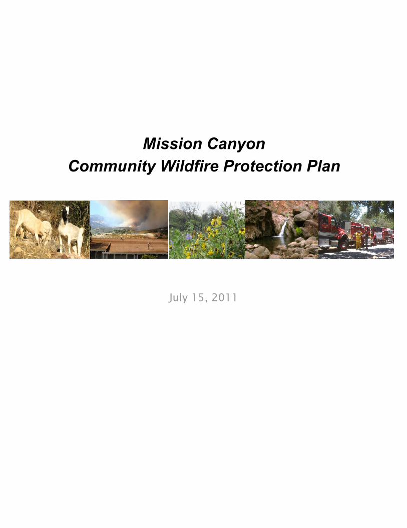
Mission Canyon
Community Wildfire Protection Plan
July 15, 2011
- 2 -
Declaration of Agreement
The Community Wildfire Protection Plan developed for the community of Mission Canyon in Santa Barbara County, California:
• Was collaboratively developed. Interested parties and federal land management agencies managing land in the vicinity of Mission Canyon have been consulted.
• This plan identifies and prioritizes areas for hazardous fuel reduction treatments and recommends the types and methods of treatment that will protect the community of Mission Canyon.
• This plan recommends measures to reduce the ignitability of structures throughout the area addressed by the plan.
The Healthy Forests Restoration Act requires that the applicable local government, local fire department, and State agency responsible for forest management agree to the Community Wildfire Protection Plan. The undersigned have reviewed the Mission Canyon CWPP and agree to this completed document. For convenience, the Mission Canyon Community Wildfire Protection Plan may be signed in two or more counterparts, each of which shall be deemed an original and all of which together shall constitute the same Mission Canyon Community Wildfire Protection Plan. _____________________________________________ ___________ Joni Gray, Chair Date Santa Barbara County Board of Supervisors _____________________________________________ ___________ Michael Dyer, Fire Chief Date Santa Barbara County Fire Department _____________________________________________ ___________ Rob Lewin, Unit Chief Date CalFire, San Luis Obispo County
- 3 -
Table of Contents
Declaration of Agreement 2 Contact Information 4 Purpose 5 Legislation and Regulation 5 Collaboration 7 Community Base Map 7 Community Profile 8 Communities at Risk 9 Wildland Urban Interface Description 10 Mission Canyon CWPP Boundary and Surrounding Areas Map 11 Conservation Principles for Community Wildfire Protection 11 in the Santa Barbara Front Country Community Assessment of Risk 16 Fuel Hazards 17 Risk of Wildfire Occurrence 24 General Wildfire Environment Descriptions 26 Local Preparedness and Firefighting Capability 32 Fire Safety Objectives 33 Prioritized Treatments and Goals for Fuels Reduction 35 Funding Sources 39 Implementation and Maintenance 39 Organizational Responsibilities 40 Sustaining the MC-CWPP and Vegetation Management Projects 40 Updating the MC-CWPP 41
- 4 -
Contact Information
Michael Dyer, Fire Chief Santa Barbara County Fire Department
4410 Cathedral Oaks Road Santa Barbara, California 93110
(805) 681-5500 sbcfire.com
Rick Todd, Fire Marshal Santa Barbara County Fire Department
4410 Cathedral Oaks Road Santa Barbara, California 93110
(805) 681-5500 sbcfire.com
Ray Smith, President Mission Canyon Association
P.O. Box 401 Santa Barbara, California 93102
(805) 682-5583 missioncanyon.org
Bob Tanner, Captain Vegetation Management Section
Santa Barbara County Fire Department Post Office Box 843
Buellton, California 93427 (805) 686-5068
sbcfire.com
- 5 -
Mission Canyon
Community Wildfire Protection Plan
Purpose
The purpose of the Mission Canyon Community Wildfire Protection Plan (CWPP) is to:
• Identify potential areas for hazardous fuel reduction treatments, increase the community’s understanding of living in a fire-adapted ecosystem, and improve its ability to prepare for, respond to and recover from wildland fires; and
• Recommend best practices fuel reduction treatments to protect lives and reduce structural ignitability of property, and recommend best practices to improve the fire resilience of the landscape while protecting other ecological, social, and economic values
As well as recommending priorities and strategies in the wildland urban interface and vicinity, this CWPP will assist the Santa Barbara County Fire Department and Mission Canyon area residents in the identification of surrounding lands, including federal and state lands, at risk from catastrophic wildland fire. The effectiveness and impact of the modalities used from year to year will help inform future goals and methods.
Legislation and Regulation
In 2003, Congress passed legislation: the Healthy Forests Restoration Act (HFRA). The legislation directs federal agencies to collaborate with communities in developing a Community Wildfire Protection Plan, which includes the identification and prioritization of areas needing hazardous fuels treatment. It further provides authorities to expedite the National Environmental Policy Act (NEPA) process for fuels reduction projects on federal lands. The act also requires that 50% of funding allocated to fuels projects be used in the wildland urban interface.
Environmental Review
For communities with a Community Wildfire Protection Plan, the Healthy Forests Restoration Act, 16 USCS §§ 6501-6591, provides the potential for prioritized federal funding for hazardous fuel reduction projects on non-federal land. In California, the California Fire Safe Council accepts
- 6 -
applications for potential grants that may be used to fund: hazardous fuel reduction and maintenance projects on non-federal land; community risk assessments and Community Wildfire Protection Plans; and education and outreach opportunities for landowners and residents in at-risk communities. Public agencies and/or private parties that comply with applicable legal requirements, though, may be able to conduct hazardous fuel reduction without having a Community Wildfire Protection Plan and/or without receiving grant funding. This CWPP will help to increase awareness of the possible ecological consequences of wildland fuel management practices, so that individual fuel reduction projects avoid or minimize harm to the environment when feasible. Approval of the Mission Canyon Community Wildfire Protection Plan does not:
• Commit any signing party or anyone to carrying out, funding, or issuing a permit for any specific hazardous fuel reduction;
• Require implementation of any of the recommendations presented herein; or
• Remove any permit requirement, environmental review requirement, or other legal requirement applicable to hazardous fuel reduction on either private lands or public lands.
Implementation of any recommended “best practice” or recommended hazardous fuel reduction within this CWPP might be modified, or not implemented at all, depending on a number of factors, including: environmental review; permit actions; and the availability of funding. Any necessary environmental review required by the California Environmental Quality Act (CEQA) and/or the National Environmental Policy Act (NEPA) shall be completed prior to commencement of any recommended hazardous fuel reduction. Under California Public Resources Code § 21065, individual hazardous fuel reduction projects may be subject to CEQA review, for example, if they are:
• Carried out by a public agency;
• Funded by a public agency; or
• Issued a permit from a public agency. County Code Chapter 9A regulates brush removal in the southeasterly coastal area of the unincorporated area of Santa Barbara County. Unless subject to an exception through County Code Section 9A-6, no person may remove natural vegetation within that area without approval from the Building and Safety Division of the Planning and Development Department. Exceptions that County Code Section 9A-6 provides from that permit requirement include: removal of not more than five acres of vegetation from a parcel within any 12-month period; removal performed by or required by the fire prevention agency; removal on certain rights-of-way; controlled burns by the fire prevention agency; certain agricultural preparation methods; and removal in connection with certain grading permits. Fuel reduction projects that require a brush removal permit under County Code Chapter 9A will be subject to CEQA review, unless exempted from CEQA by the State’s Guidelines for the California Environmental Quality Act. As an example, CEQA Guidelines § 15304(i) provides an exemption from CEQA for fuel management activities within 30 feet of structures, to reduce the volume of flammable vegetation, provided that the activities will not result in the taking of endangered, rare, or threatened plant or animal species or significant erosion and sedimentation of surface waters. This exemption also applies to fuel management activities within 100 feet of a structure if the public agency having fire protection responsibility for the area has determined that 100 feet of fuel clearance is required due to extra hazardous fire conditions. Section 4914.4.1(b) of County Code
- 7 -
Chapter 15, Fire Prevention, requires a “Reduced Fuel Zone” for brush, flammable vegetation, or combustible growth that is located within 100 feet from a building or structure to the property line. People who have questions about permit and/or environmental review requirements for specific
fuel reduction projects may contact Santa Barbara County Planning and Development Department at (805) 568-2000.
Collaboration
The initial creation of the Mission Canyon CWPP was first discussed in 2006 among members of MCA and the Santa Barbara County Fire Department (CFD). After review of the Fire Department’s Wildfire Protection Plan and MCA’s Fire Plan, a single plan meeting the objectives of the Healthy Forests Restoration Act was found to serve both entities more efficiently. This plan was assembled around 2008 with help from MCA, CFD, Santa Barbara City Fire Department, USDA Forest Service - Los Padres National Forest, Santa Barbara County 1st District Supervisor and staff, Santa Barbara Botanic Garden, and Santa Barbara County FireSafe Council. Additional private and public entities and resources, as well as Cal Fire, were also consulted. The current update is a compilation of ideas that support the desired outcome of the community and numerous local organizations, including several environmentally oriented groups who added a level of sensitivity to the environmental effects of potential wildland fuel management activities. It hopes to offer an approach that can be implemented to accomplish the fire prevention goals desired by fire service organizations, homeowners, and interested parties alike. The Mission Canyon CWPP is a working document and will require adjustments and updates to reflect changes within the Mission Canyon community, advancements in the practices of vegetation management, and updates in environmental policy at the local, state, and federal levels. Reference material pertinent to the development of the Mission Canyon CWPP came from Preparing a Community Wildfire Protection Plan: A Handbook for Wildland-Urban Interface Communities (Communities Committee, National Association of Counties, National Association of State Foresters, Society of American Foresters, Western Governors’ Association, 2005), Mission Canyon Fire Plan – Version 5 (MCA, 2007), Santa Barbara Botanic Garden Fire Protection Plan (2006), Sierra Nevada Community Conservation and Wildfire Protection Plan Guidebook, as well as memoranda and directives from Cal Fire.
Community Base Map
The data used for the Mission Canyon Community Wildfire Protection Plan was obtained from the most current information and data from the County of Santa Barbara, Cal Fire’s Fire and Resource Assessment Program (FRAP), United States Forest Service, United States Geological Survey (USGS), and the Santa Barbara County Fire Department. The maps and GIS data within the Mission Canyon CWPP are created from the most accurate data available. The projection used for maps and GIS data is North American Datum (NAD) 83 State Plane California Zone V.
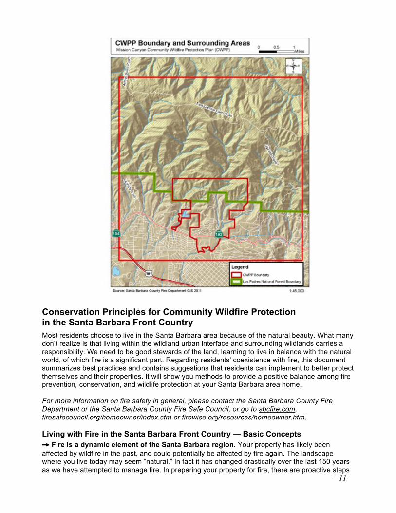
The Mission Canyon CWPP Base Map represents the area in which most fuels modification, vegetation management, community planning, distribution of education resources, and fire safety practices would be focused. The CWPP Boundary, as drawn, contains land within the County of Santa Barbara but excludes all land within City of Santa Barbara. However, the residents and fire agencies are very cognizant of the fact that the chaparral-covered south-facing slopes—which are largely owned by the federal government—above Mission Canyon and the City of Santa Barbara pose a significant fire risk to the community far beyond the Base Map perimeter. Therefore, the Mission Canyon CWPP Boundary and Surrounding Areas map (see page 11) perimeter is much
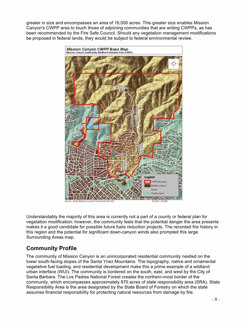
- 8 -
greater in size and encompasses an area of 16,000 acres. This greater size enables Mission Canyon's CWPP area to touch those of adjoining communities that are writing CWPPs, as has been recommended by the Fire Safe Council. Should any vegetation management modifications be proposed in federal lands, they would be subject to federal environmental review.
Understandably the majority of this area is currently not a part of a county or federal plan for vegetation modification; however, the community feels that the potential danger the area presents makes it a good candidate for possible future fuels reduction projects. The recorded fire history in this region and the potential for significant down-canyon winds also prompted this large Surrounding Areas map.
Community Profile
The community of Mission Canyon is an unincorporated residential community nestled on the lower south-facing slopes of the Santa Ynez Mountains. The topography, native and ornamental vegetative fuel loading, and residential development make this a prime example of a wildland urban interface (WUI). The community is bordered on the south, east, and west by the City of Santa Barbara. The Los Padres National Forest creates the northern-most border of the community, which encompasses approximately 870 acres of state responsibility area (SRA). State Responsibility Area is the area designated by the State Board of Forestry on which the state assumes financial responsibility for protecting natural resources from damage by fire.
- 9 -
South of Foothill Road (State Highway 192), there are approximately 160 acres of Local Responsibility Area (LRA), which is considered part of the Mission Canyon community and is under the response jurisdiction of the Santa Barbara County Fire Department. The population in the Mission Canyon area is approximately 3,500. There are approximately 1,112 housing units within the boundaries of the Mission Canyon Community identified in the Mission Canyon Specific Plan, which is being updated and expected to be completed by 2011. The median home price in 2010 was $850,000. In 1948, the Mission Cañon Association was organized to secure adequate fire protection by forming a fire district. The Association is governed by a Board of Directors, selected by vote of the Association's Members at the annual meeting, according to the Mission Canyon Association By-Laws. Additional information about the Mission Canyon Association can be found at missioncanyon.org. Over the past two decades, the Mission Canyon Association has made education and outreach to its community a top priority in its fire education efforts. By informing the community of fire issues in numerous informal, face-to-face meetings and workshops over the past decade, MCA members have helped to foster a greater sense of community coherence. Development of the original and the current CWPP is an outgrowth of this sense of community.
Communities at Risk
The Healthy Forest Initiative (HFI) and the Healthy Forests Restoration Act (HFRA) define a “community at risk” from wildland fire as one that:
! Is a group of homes and other structures with basic infrastructure and services
(such as utilities and collectively maintained transportation routes) in or adjacent to federal land
! Has conditions conducive to large-scale wildland fire
! Faces a significant threat to human life or property as a result of a wildland fire
Mission Canyon is both an urban-wildland interface and intermixed target area lying in topography typical of Southern California canyons—steep and narrow with winding roadways that make rapid ingress and egress a challenge. Few spaces for turnarounds exist along the roads, which also have patches where little vegetation clearance has taken place. MCA is aware that there are numerous private roads, serving multiple residences, that were built before current fire department standards. There are few areas where firefighters can work safely to protect this area in a major fire event and even fewer areas that meet the recognized standards for Firefighter Safety Zones. Mission Canyon Communities at Risk
On January 4, 2001, for the purposes of the National Fire Plan, the Department of Interior (DOI) published in the Federal Register a “Notice of Urban-Wildland Interface (WUI) Communities Within the Vicinity of Federal Lands That Are at High Risk from Wildfire.” The following list contains the federally regulated (communities which adjoin federal lands) communities at risk within Santa Barbara County:
• Carpinteria • Casmalia • Cuyama • Vandenberg Village
• Lompoc • Gaviota • Mission Hills • Vandenberg Air Force Base
• Tajiguas • Orcutt • Santa Barbara (including Mission Canyon)
After the 2000 fire season, the California Department of Forestry and Fire Protection (Cal Fire), working with the California Fire Alliance, developed a list of communities at risk from wildfire using 1990 Census and USGS Geographic Names Information System data to identify populated places,
- 10 -
and Cal Fire’s Fire and Resource Assessment Program (FRAP) fuel hazard data. In addition to the already-mentioned communities, they designated the following as WUI Communities at Risk:1
• Buellton • Garey • Guadalupe
• Los Olivos • Santa Maria • Santa Ynez (federal threat)
• Sisquoc • Summerland • Ventucopa (federal threat)
• Solvang • Los Alamos • Montecito (federal threat)
Wildland Urban Interface Description
The Healthy Forests Restoration Act defines wildland urban interface (WUI) as an area within or adjacent to an at-risk community that has been identified by a community in its wildfire protection plan. Mission Canyon has been identified as such an area. The area is identified as:
! Extending ! mile from the boundary of an at-risk community
! Extending 1 ! miles from the boundary of an at-risk community when other
criteria are met such as a sustained steep slope or a geographic feature that creates an effective firebreak, or is classified as Condition Class 3 land,
! Adjacent to an evacuation route.
The map at page 11 shows the Mission Canyon CWPP borders and the larger surrounding area—seen here to encompass16,000 acres—in order to acknowledge lands that have the potential to directly affect Mission Canyon because fire embers can spread a half-mile or more into faraway vegetation in a down-canyon wind scenario. This large area does not mean projects are envisioned in this document for those outer regions, but is included to show that should a wildland fire start anywhere inside the area shown, due to fuels, weather, and topography, the community could be threatened. The region has had numerous large-scale fires due in part to the increased rates of spread caused by down-canyon wind events. Called Sundowner winds because they often begin in the late afternoon or early evening, their onset is typically associated with a rapid rise in temperature and decrease in relative humidity. In the most extreme Sundowner wind events, wind speeds can be of gale force or higher, and temperatures over the coastal plain, and even at the coast itself, can rise significantly above 100°F. The northern area of influence boundary includes East Camino Cielo Road. This road runs west to east along the ridgeline of the Santa Ynez Mountain Range and is the geographical split between the north and south aspect of the ridgeline respectively. A line drawn roughly due south of Arroyo Burro Road is the western boundary and Gibraltar Road is the eastern boundary running in a north-south axis. The eastern boundary includes private lands within the county and city, and land under federal jurisdiction. Simply to create a symmetrical box, the southern-most boundaries appear to include portions of the City of Santa Barbara; however, the CWPP actually excludes all lands within City of Santa Barbara. This symmetrical box includes the entire Mission Canyon region and indicates adjoining areas that could be affected by similar fire hazards, which are outlined in the Santa Barbara City Wildland Fire Plan. The efforts described in that plan are likely to enhance Mission Canyon's fuels reduction efforts because they are part of the Community Fuels Treatment Network identified within the City's Wildland Fire Plan.
1 California Fire Alliance. “Communities At Risk History.”
cafirealliance.org/communities_at_risk/communities_at_risk_history.
- 11 -
Conservation Principles for Community Wildfire Protection in the Santa Barbara Front Country
Most residents choose to live in the Santa Barbara area because of the natural beauty. What many don’t realize is that living within the wildland urban interface and surrounding wildlands carries a responsibility. We need to be good stewards of the land, learning to live in balance with the natural world, of which fire is a significant part. Regarding residents' coexistence with fire, this document summarizes best practices and contains suggestions that residents can implement to better protect themselves and their properties. It will show you methods to provide a positive balance among fire prevention, conservation, and wildlife protection at your Santa Barbara area home. For more information on fire safety in general, please contact the Santa Barbara County Fire Department or the Santa Barbara County Fire Safe Council, or go to sbcfire.com,
firesafecouncil.org/homeowner/index.cfm or firewise.org/resources/homeowner.htm.
Living with Fire in the Santa Barbara Front Country — Basic Concepts
" Fire is a dynamic element of the Santa Barbara region. Your property has likely been
affected by wildfire in the past, and could potentially be affected by fire again. The landscape where you live today may seem “natural.” In fact it has changed drastically over the last 150 years as we have attempted to manage fire. In preparing your property for fire, there are proactive steps
- 12 -
you can take to make your structure(s) defensible. While it is rarely practical to completely “fire proof” your property, there are many steps you can take to survive inevitable wildfire. For more
information see www.fire.ca.gov/education_content/downloads/live_w_fire.pdf.
" One size does not fit all in terms of homeowner fire safety. Every community is unique. The
Santa Barbara County Fire Safe Council,2 Santa Barbara County Fire Department, Planning & Development Department, and/or contractors can work with you to design the appropriate fire-safe
practices3 and defensible space4 for your property. See www.sbcfire.com for additional information on defensible space standards. " Your home exists within a larger watershed.5 It is located in the midst of a much larger
landscape. Think about where your property is on the slope.6 Are you on top of a ridge, where fire will easily burn toward your home? Is your slope steep or gentle? Fire moves quickly up steeper slopes, which means that you may need to treat a larger area to create your defensible space. What is below and above you? What direction, or “aspect,”7 does your property face? Generally, south-facing properties are hotter and drier; they can therefore be more susceptible to fire. Are there any natural firebreaks around you such as streams or rocky outcrops where a fire might naturally go out? Do the roads in and out of your property follow ridges or natural drainages? When evaluating your property, consider how your home and property would be affected during a wind-driven fire. Are there changes in defensible space or structural modifications that will make your home more fire safe? " Fire can behave both predictably and unpredictably. We can generally predict fire direction
and behavior; it will go the way the wind is blowing and burn as much fuel as is available. Predicting the exact time and place where fire will burn is less obvious. As fire moves across the landscape it can spread into trees and the tree canopy. A key fire safety objective is to prevent that spread. Dead leaves and branches on the ground (surface fuels8) act as a wick to move fire horizontally across the land. Shrubs, small trees, and live branches (ladder fuels9) can carry fire vertically into the larger trees. Too much of these surface and ladder fuels can cause the over story
trees to burn up in what is called a “crown fire”—when fire spreads from tree to tree in the tree canopy (or tree tops). One of the main principles in creating defensible space and reducing hazardous fuel conditions is to create physical space between vegetation layers (both vertically
2 Fire Safe Council: Public and private organizations that comprise a council intended to minimize the potential for
wildfire damage to communities and homeowners, while also protecting the health of natural resources. Goals are
achieved by distributing fire prevention materials, organizing fire safety programs, implementing fuel reduction
projects, and more.
3 Fire Safe Practices: Activities such as creating defensible space, firebreaks, access to your home, fire-resistant
landscapes, changes to your home in terms of material and design, etc., that make your home/property safer in
wildfire situations.
4 Defensible Space: An area around a home/structure that has been cleared of flammable materials to act as a barrier
between wildfires and property, thereby decreasing the risk of damage or loss. This space is now defined as a
minimum of 100 feet around a structure in California.
5 Watershed: All of the land that drains water runoff into a specific body of water. Watersheds may be referred to as
drainage areas or drainage basins. Ridges of higher elevation usually form the boundaries between watersheds by
directing the water to one side of the ridge or the other. The water then flows to the low point of the watershed.
6 Slope: A percentage or degree change in elevation over a defined distance that measures the steepness of a landscape.
7 Aspect: The direction that a slope faces—north, south, east, west, etc.
8 Surface Fuels: Materials on the ground like needles or low-growing shrubs that provide the fuel for fires to spread on
the ground. Surface fuels are generally considered all fuels within six feet of the ground.
9 Ladder Fuels: Materials such as shrubs or small trees connecting the ground to the tree canopy or uppermost
vegetation layer. This allows fire to climb upward into trees.
- 13 -
and horizontally) so a fire cannot climb easily from the ground into the trees or to your home. See www.sbcfire.com for more information.
" Timing is everything. Defensible space and fuel reduction work should be done well before
high fire season to avoid having sparks from equipment start fires in dry vegetation. Ground-disturbing activities on your property should be avoided when the ground is too wet. Fire safety can be a seasonal activity, planned for the winter and spring; clearing can start when the ground begins to dry (when it’s not saturated); treatments can be finished by early summer before the vegetation is dry; defensible space maintenance can be done around and inside your home in the fall. See
celosangeles.ucdavis.edu/Natural_Resources/Wildland_Fire.htm for more information.
" Your house is likely a fuel source. Many Southern California homes are located in places
where a fire can start and spread into surrounding vegetation. The more you prepare your house and other structures, the less you may have to treat the surrounding vegetation. The biggest improvement you can make to reduce your fire risk is to build or remodel your house to resist the millions of tiny embers10 created by ember-attack11 from wildfires. When wildfires burn in extreme conditions, they send burning firebrands (embers) ahead of them; these firebrands ignite new fires. Using fire-resistant building materials and appropriately designed structures can give you the best chance to survive wildfire. Wood shake roofs can be replaced with fire-resistant materials. Don’t let your home be part of the problem. An interactive source of information to reduce homeowner risk in the WUI is provided by the
University of California, Center for Fire Research and Outreach; it’s called the Fire Information
Engine Toolkit. See firecenter.berkeley.edu/toolkit/ homeowners.html for details on how this web-based program can help you make better decisions to reduce your fire risk, and the related UC
Extension’s Homeowner’s Wildfire Mitigation Guide groups.ucanr.org/HWMG/index.cfm. If you are building a new home, you may want to consider slope, aspect, surrounding fuels, and your potential environmental impacts before deciding where to site your home. This may be more important than the view in the long term. The Santa Barbara County Building Department can inform you of local fire-safe building regulations, many of which were updated in 2008. " Know your legal obligations. Many legal requirements
exist regarding defensible space and fire-safe building and construction. There are ways to balance these with the ecological needs of your property. " Firefighters need your help to protect your home. Safe
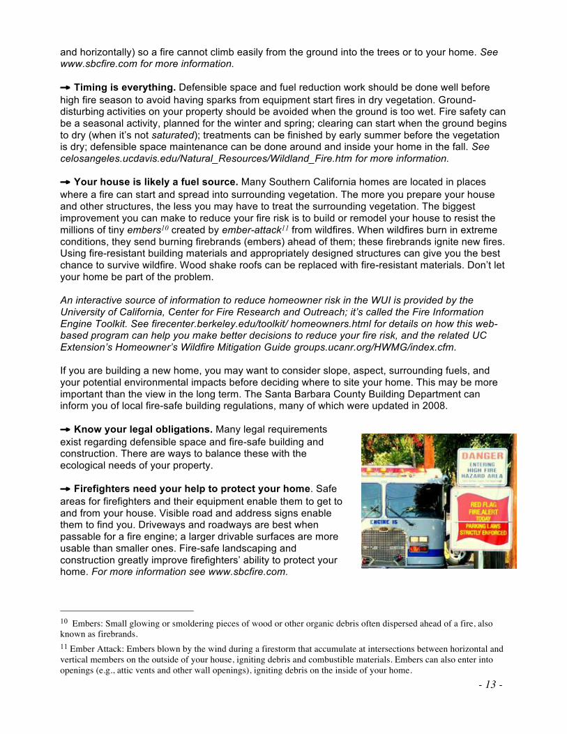
areas for firefighters and their equipment enable them to get to and from your house. Visible road and address signs enable them to find you. Driveways and roadways are best when passable for a fire engine; a larger drivable surfaces are more usable than smaller ones. Fire-safe landscaping and construction greatly improve firefighters’ ability to protect your home. For more information see www.sbcfire.com.
10 Embers: Small glowing or smoldering pieces of wood or other organic debris often dispersed ahead of a fire, also
known as firebrands.
11 Ember Attack: Embers blown by the wind during a firestorm that accumulate at intersections between horizontal and
vertical members on the outside of your house, igniting debris and combustible materials. Embers can also enter into
openings (e.g., attic vents and other wall openings), igniting debris on the inside of your home.
- 14 -
Conservation Principles
The Conservation Principles below can help you become aware of and balance fire safety and defensible space with an aesthetically pleasing landscape that is fire-safe, supports local plant and animal species, and still provides you with privacy and plantings.
Remember the Vegetation (Native Vegetation and Ornamental Plants)
• Conservative actions.
As fuel treatments are implemented, a more fire-resilient landscape is being manually re-created. The general concept of the precautionary principle12 says that you can always remove more trees and vegetation at a later time, but you cannot immediately replace what you have cut. The vegetation you leave is ultimately most important. Careful planning and consideration prior to the removal of trees and vegetation ensures that what you leave standing is healthy and resilient. See www.mindfully.org/ Precaution/Precautionary-
Principle-Common-Sense.htm for more information.
• Native species protection.
A look at the native vegetation around your property can show you the different plants that share your home. There may be plants that are rare. Providing defensible space and considering their needs, such as shade, can help protect such plants. Other areas within your watershed where these plants exist may provide information on how they are being managed there. Unnecessary water in the landscape has been known to generally help nonnative plants outcompete native plants. See www.cnps.org/activities/natives.htm, www.cal-ipc.org, and
www.ipm.ucdavis.edu/PMG/weeds_common.html for more information.
Vegetation treatments are frequently followed by invasive weeds13 that come in and take root. If that happens, invasive weed removal may become necessary. The introduction of exotic plant species near your home, especially those that can spread into adjacent wildland areas, can change your fire hazard very quickly and be difficult to manage.
Remember the Wildlife
• Local wildlife.
Animals no doubt share your property. Their needs include shelter, food, water, reproduction, and movement along wildlife trails and corridors on your property. By finding ways to balance your land management activities with their needs, and by leaving some areas untreated for the birds and wildlife using them, you can protect them as you would your home by creating defensible space while still considering their needs for cover. For
more information, see www.fs.fed.us/psw/rsl/projects/wild/verner/psw_37.html, and cetuolumne.ucdavis.edu/newsletterfiles/Master_Gardener_Articles_20044858.doc. There is a California nesting season for birds—February through August—that should be taken into consideration when doing tree work. When cutting, trimming, or otherwise disturbing trees (with construction, for instance) during those months, the trees in the area should be checked for nests. If nests are found, a good practice is to avoid the trees until
12 Precautionary Principle: A concept that promotes a cautious approach to development and managing the environment
when information is uncertain or unreliable. Erring on the side of caution and conservation is encouraged, along with a
“Better safe than sorry” attitude. 13 Invasive Weeds: Undesirable plants that are not native and have been introduced to an area by humans. These plants
generally have no natural enemies and are able to spread rapidly throughout the new location. Some examples include
Himalayan blackberries, English ivy, and Scotch broom.
- 15 -
the fledglings have flown away. Migratory birds are protected by the federal Migratory Bird Treaty Act, which makes it illegal to harm or kill migratory birds, their eggs, feathers, or nests. See www.fws.gov/migratorybirds/regulationspolicies/mbta/mbtintro.html for more. The creeks and the life they contain are another concern that may not be obvious to those with properties well beyond the creek banks. Steelhead trout are only just beginning to return to Mission Creek and its tributaries. Impacts from such things as erosion and pesticide use on lands above the creeks have the potential to negatively affect steelhead recovery and the health of the creeks in general.
Remember the Soil
• The life in your soil.
There is as much or more activity below the ground on your property as there is above the ground. Local experts can tell you what soil types are on your property. Some soil types can tolerate much more disturbance than others. There are several places within the Mission Canyon Surrounding Areas that have been affected by past erosion, and these areas need to be worked on accordingly. Be aware of activities that could compact, flood, or alter your soil. The health of your land is directly dependent on the health of your soil. As such, the soil is one of the most valuable assets of your property. See managingwholes.com/new-
topsoil.htm for more information.
• Soil cover and fire safety.
Cover that burns easily (such as dry or dead vegetation) is less desirable than cover that is less flammable (e.g., gravel, fleshy green plants, etc.). The objective is to ensure that if and when a fire comes through, it is not so hot that it kills the life in your soil. Rather, it should move through without a lot of fuel to consume in its path. For example, a very light layer of oak litter can help with soil erosion (see below), but too much can be a fuel problem. See www.laspilitas.com/classes/fire_burn_times.html for more information.
• Erosion.
Keeping your soil covered can protect it. Cover helps to prevent erosion, especially on ground that is not flat; it keeps the soil in place. When soil moves across your property, it can get into streams or other natural water sources. Steep slopes can be a special problem. The steeper the slope, the faster the soil can move downhill if it’s disturbed, and the faster a fire can climb uphill under the right (or wrong!) conditions. For more information see www.uri.edu/ce/healthylandscapes/tips/6.html and www.pfmt.org/fire/topos_effect.htm.
• After a fire.
Soil can be most fragile after a wildfire. This is often exacerbated when winter rains come soon after a fire. The potential for erosion and loss of soil is huge with this combination of conditions. If you have experienced fire on your property, adding cover to your soil will help prevent erosion. See www.ext.colostate.edu/PUBS/NATRES/06308.html and
www.cnr.uidaho.edu/extforest/AftertheBurnFINAL.pdf for more information. Cal Fire and the USFS have special rehabilitation teams to survey fire damage and ensure areas are prepared for post-fire events such as heavy rains and problems associated with erosion.
Remember Your Community
• Neighbors.
Talking with neighbors and sharing ideas enables broader land and vegetation management. The Mission Canyon Association has been instrumental in coordinating neighborhood brush clearance days that have made a significant impact on the community. Each homeowner's defensible space very likely impacts a neighbor’s chances of surviving a
- 16 -
wildfire and vice-versa. Conversation about what to do in an emergency and how to most safely evacuate can also be productive. The Santa Barbara County Fire Safe Council (FSC) and the Mission Canyon Association plan fire-related events that community members can take part in.
• Experienced workers.
If your objective is to reduce fuels while still maintaining ecological integrity and diversity on a site, your workers should have the knowledge and experience to help you achieve this. Your workforce can be influential in the design, planning, and monitoring of projects. Members of the Santa Barbara County Fire Safe Council, Mission Canyon Association, Santa Barbara County Fire Department Vegetation Management Section, and neighbors could be helpful. Reputable contractors have good references.
• Your local fire department.
Your local firefighters at the County Fire Department or the USFS can tell you what they need to safely get to your house and back out. Safe access roads with maintained fuel treatments along all roads are both for firefighter safety in protecting your home and your safety in case of evacuation. Many areas within Mission Canyon were developed prior to current road standards and access, and residents are well advised to do everything they can to improve access to their residence. It helps firefighters, including out-of-town firefighters, know where you live when street and address signs are visible. A visit to your property can enable local firefighters to know where you have a water supply they can find and use. Hydrants should be visible and clear of vegetation. Know where and how to turn off any fuel sources such as natural gas or propane.
Community Assessment of Risk
The Mission Canyon CWPP is based on five categories of evaluation that include a variety of information designed to identify and evaluate wildland fire risk within and surrounding the area:
! Fuel hazards
! Risk of wildfire occurrence
! Homes, businesses, and essential infrastructure at risk
! Other community values at risk
! Local preparedness and firefighting capability
Mission Canyon residents have been kept up-to-date on the rationale, goals, and methods contemplated in the CWPP process by the Mission Canyon Association through its monthly Board of Directors meetings that are open to all residents, Annual Meetings, and quarterly newsletters, which all invite community comment. This Mission Canyon CWPP was finalized following consultation with the Santa Barbara Botanic Garden, Friends of Mission Canyon, Mission Canyon Planning Advisory Committee, Santa Barbara's Environmental Defense Center, Urban Creeks Council, the County of Santa Barbara, and Cal Fire/San Luis Obispo Unit. Additionally, the May 19, 2011-version of the draft CWPP was made available on the Mission Canyon Association website in May 2011 and notices emailed to the groups listed below with a request for comments. Further, a meeting was held for the groups listed below on May 31, 2011, in order to provide an overview of the CWPP and invite comment. Those groups are: Bureau of Land Management, U.S. Forest Service, California Department of Fish and Game, Caltrans, Cachuma Operation and Maintenance Board, County Public Works, County Office of Emergency Management, County Parks, Montecito Fire Protection District, Santa Barbara Fire Safe Council,

- 17 -
City of Santa Barbara Water Resources Division, City Parks, Santa Barbara Multi-Jurisdictional Trails Task Force, Edison Company, Cox Cable Company, Sierra Club, Audubon Society, Los Padres Forest Watch, Frank Arredondo, Multi-Use Trails Coalition, Santa Barbara Mountain Bike Trail Volunteers, Santa Barbara Trails Council, Santa Barbara Museum of Natural History, Holly Road Association, Spyglass Road Association, and the residents of Mission Canyon. Additionally, notice was given to the National Marine Fisheries Service, U.S. Fish and Wildlife in Ventura, and the U.S. Bureau of Reclamation and comment solicited.
Fuel Hazards
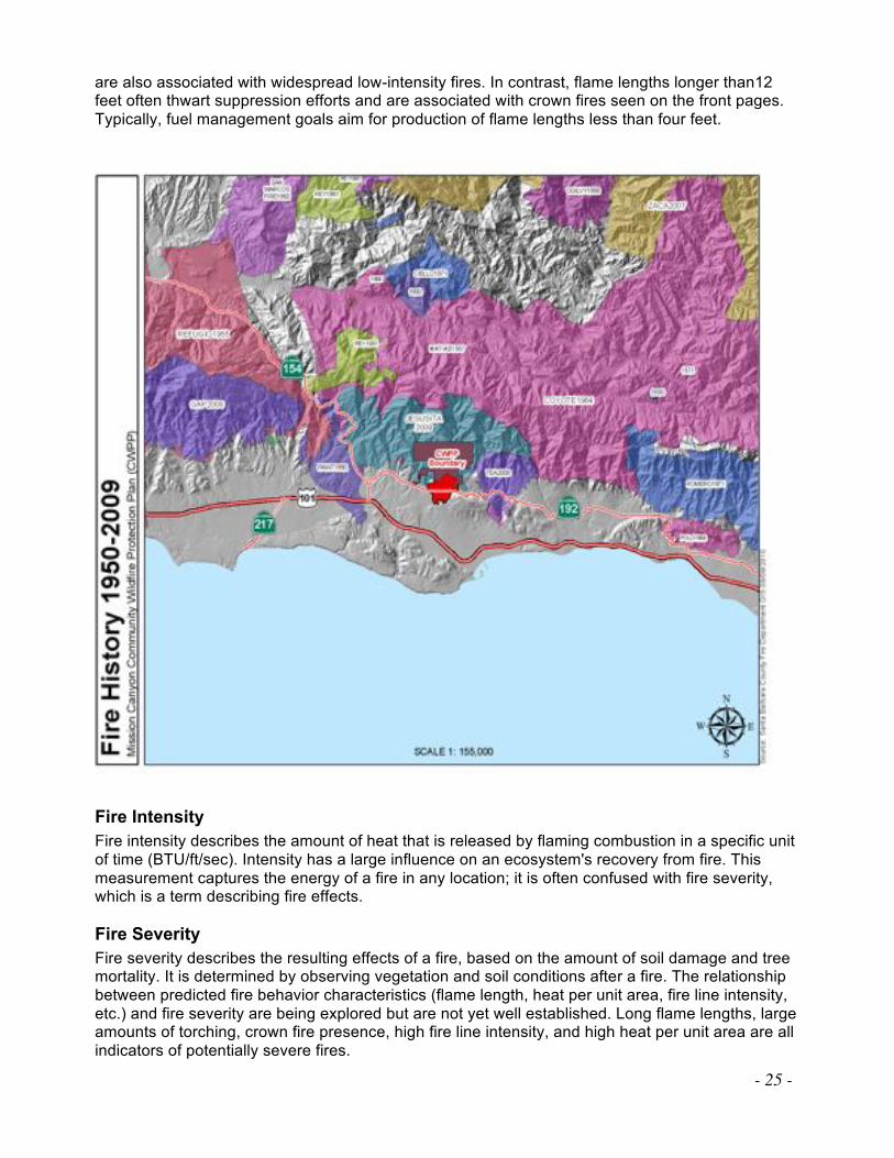
The Mission Canyon CWPP discusses elements of fire prevention that could influence the outcome of a wildland fire. As a planning tool, the CWPP can help identify preplanning elements that could increase both human and structure survivability within Mission Canyon and the Santa Barbara front country. Natural elements, such as weather and topography cannot be altered; however, acknowledging how these elements affect a wildfire are vitally important. Land use and development standards can have a positive effect on the community and further promote the fire and life safety concerns that residents now share. Many of these planning needs are addressed in the 2011 Mission Canyon Community Plan, which is in the drafting stage as this CWPP is being written. As a planning tool, the CWPP will also identify the extreme potential of fire spread during the periods of extreme wind and low relative humidity, which contribute to red flag conditions. The bulk of Santa Barbara County’s 1,751,680 acres are covered with fire-prone vegetation. These large areas of vegetation are commonly referred to as “fuel beds” and are often large in size due to steep topography and lack of roads or natural barriers. These large fuel beds are on some of the nation’s steepest and roughest topography. The average slope in the wildland areas is 40%. Within the Mission Canyon CWPP Base Map the average slope is 12%. The slope within the overall Mission Canyon CWPP surrounding areas (within the Mission Canyon drainage) averages 33%.
Since the Jesusita Fire burned the hillsides of Mission Canyon in 2009, chaparral has regrown and provides the most widespread wildland fuel threat within the Mission Canyon CWPP area. Also, numerous dead trees dot the canyon, some affected by Jesusita, others by other causes, but all
The influence of wildland fire hazard into urban areas can range from only about 200 feet in low hazard conditions, to nearly a mile in very high hazard areas. The nature and depth of the zones are a function of both how likely a flame front will penetrate, and how many firebrands are expected to land in the urbanized area. The FHSZ map identifies the fuel modeling within the Mission Canyon Base Map Perimeter.
- 18 -
representing potential hazardous fuel. The most current fuel model data is the Standard Fire Behavior Fuel Models: A Comprehensive Set for Use with Rothermel’s Surface Fire Spread Model (June 2005). Using this data, the Mission Canyon CWPP fuel bed falls in the category of a High Load, Dry Climate Shrub SH5 (145). The primary carrier of fire in SH5 is woody shrubs and shrub litter with a heavy shrub load at a depth of 4-6 feet. Spread rate is very high, and flame length is also very high. Moisture of extinction is high, meaning that even with a high fuel moisture content (amount of moisture/water in the fuel), it does not take much to make it burn. This model is dynamic; because of the deep layers of live and dead plants, as fire burns through the herbaceous load, it hits successive strata of dry and moist fuels. This significantly affects fire behavior as the herbaceous load shifts between live and dead. In addition to the native vegetation, there is a high volume of ornamental vegetation in the residential areas that adds to the overall fuel loading within the Mission Canyon area. The 2008 Fire Hazard Severity Zone (FHSZ) map prepared by Cal Fire does not differentiate between ornamental and native vegetation, rather an average of fuel loading is determined. Urban zones are scored based on their proximity to wildland zones and the flame score for that wildland zone, the number of firebrands being produced in the wildlands and received in the urban area, and the amount of vegetation fuels present in the urban zone. Urban areas immediately next to wildland zones typically have the highest hazard, and areas more removed from the wildlands have lower hazards.
Chaparral Role of Fire
Chaparral has been described as a fire-adapted ecosystem. Some chaparral requires fire for its regeneration and to reduce competition. In foothill chaparral, the absence of fire can result in dense, tall stands of shrubs that have a low diversity of both shrub and herbaceous species. Much of the chaparral in upper Mission Canyon and the foothills of the Santa Ynez Mountains was consumed in the Jesusita Fire, which began on May 5, 2009. Significant areas of riparian habitat were also destroyed and disturbed in this fire. On May 6, a Sundowner event became established, and embers were reported starting spot fires one-quarter to one-half mile ahead of the main fire front. Jesusita ultimately burned 8,733 acres, approximately two-thirds of Mission Canyon, destroyed 80 homes and 79 outbuildings, and damaged 15 homes. The Botanic Garden reported 60% of its acres burned. The majority of structures destroyed or damaged were in Mission Canyon, though the fire reached Hwy.154 to the west. Thirty firefighters were injured in the blaze. The Tea Fire, which began on November 13, 2008, burned into the eastern edge of the Mission Canyon Base Map perimeter and consumed nearly 2,940 acres in the first operational period. The fire destroyed 210 residential structures in Montecito and the City of Santa Barbara, and severely burned two residents. Another significant fire in the Base Map perimeter was the Coyote Fire, which occurred on August 22, 1964, and consumed 67,000 acres and destroyed 20 homes. The fire claimed the life of a forest service fireman, John L. Patterson, who had attempted to escape entrapment on Romero Saddle. Chaparral Fire Regime
Regardless of whether chaparral occurs in the foothill or backcountry regions, tall, old, mature chaparral generally produces high-intensity fires. Wildfires in chaparral communities often are stand-replacing events; fires burn sufficiently hot to consume all of the aboveground plant material. A fire regime is a statistical characterization of recurring fire in an ecosystem. The natural fire regime of the Santa Barbara’s chaparral ecosystem is typically high-intensity, stand-replacing events; fires burn sufficiently hot to consume all of the aboveground plant material. On most shrub-land landscapes in Southern California extreme fire weather is the overwhelming influence
- 19 -
on the fire regime.14 15In central and southern California severe fire weather typically occurs during the autumn Santa Ana winds at the end of a six-month drought. Large chaparral fires consistently occur at the end of wet periods and the beginning of droughts with fuel moisture of the ecosystem playing an important role.16 The time between episodes of fire—the fire return interval—in chaparral is highly variable, ranging from 10 to more than 100 years. Chaparral fires generally occur in summer and fall, depending on the dryness of the year and site. The time between episodes of fire — the fire return interval — in chaparral is highly variable, ranging from 10 to more than 100 years. Chaparral Plant Adaptations to Fire
Chaparral plant communities have developed important adaptations for fire survival and regrowth. Sprouting from the underground rootstock and the stimulation of seed germination are examples of such adaptations. Some shrub species that usually reproduce by seeds are able to resprout from rootstock after fire; these plants are called facultative sprouters.17 Other shrub species either only regrow from seeds (obligate seeders18) or from rootstock (obligate sprouters19). Herbaceous plants in chaparral, which are often "fire followers," usually only become conspicuous during initial post-fire years. The seeds of many herbaceous plants remain dormant in the soil until germination is triggered directly or indirectly by fire. Examples of fire-related stimuli include heating of seeds for a particular amount of time or to a certain temperature in order to scar the seed coat to allow germination and sunlight. Smoke can cause seed germination in some species, whereas it is lethal to other species.
Chaparral Conservation and Fuel Modification Objectives
Prior to the implementation of fire-suppression policies, chaparral was an abundant native plant community where stand-replacing fire was the historic natural fire regime. Because of high-intensity fire intervals of 20 to 40 years in chaparral, and its common presence within WUI
communities such as Mission Canyon, it is important that fuel mitigation strategies are combined with the conservation and protection of this important, under-appreciated vegetation community. Objectives are to retain and protect portions of this valuable habitat while still creatively reducing and modifying fire behavior through mosaic thinning20 prescriptions. In addition to meeting fuel reduction objectives, both the retention and reduction of chaparral patches will help support wildlife habitat and a wide variety of plant communities.
14 Moritz, M.A., J.E. Keeley, E.A. Johnson, and A.A. Schaffner (2004). "Testing a basic assumption of shrubland fire
management: how important is fuel age?" Frontiers in Ecology and the Environment 2: 67-72.
15 Keeley, J.E., C.J. Fotheringham, and M.A. Moritz (2004). "Lessons from the October 2003 wildfires in Southern
California." Journal of Forestry 102(7): 26-31.
16 Mensing, S.A., J. Michaelsen, and R. Byrne (1999). "A 560-year record of Santa Ana fire reconstructed from
charcoal deposited in the Santa Barbara Basin, California." Quaternary Research 51(3): 295-305.
17 Facultative Sprouter: A species of plant that can resprout after a fire from the rootstock, although this may not be its
usual method of reproduction in the absence of fire. The ability to resprout may be dependent on the intensity of the fire.
18 Obligate Seeder: A plant that reseeds itself after fire as a means of recovery and regeneration.
19 Obligate Sprouter: A plant that resprouts after fires as a means of recovery and regeneration.
20 Mosaic Thinning: A style of vegetative thinning that creates openings and patches of vegetation to increase the
potential variety of habitat types.

- 20 -
As a general rule, avoid cutting obligate-seeding chaparral species, e.g., some varieties of ceanothus. While these plants generally have a long life in the seed bank, they will not continue to be present in the stand and produce more seeds when cut. If you look around and see species that are infrequent or unusual, perhaps only one or two of that type of plant is in the area; when you retain those specimens you will maintain the present species diversity. If you are unfamiliar with a plant, which may turn out to be rare or protected, the Santa Barbara Botanic Garden can identify plants if you bring them a sample, or you can consult the California Native Plant Society website. Mosaic or patch-retention thinning21 focuses on separating fuel continuity22 by incorporating fuel breaks in strategic locations where fire-suppression efforts have a higher chance of effectiveness. Higher levels of chaparral reduction are recommended along main roads, key ridges, spurs,23 and other strategic areas within treatment boundaries. The Santa Barbara County Fire Department, City Fire Department, and USFS have identified general project areas that will offer the community a benefit from vegetation modification. On steep and mid slopes where chaparral patches can be isolated, efforts should focus on retaining thickets.24 When planning treatments for chaparral reduction or retention, take into consideration fuel conditions, fuel profile areas to be created, biomass utilization potential and accessibility, as well as the end-result for each site-specific location.
Chaparral Fuel Modification Best Practices
Thinning
Mosaic thinning is a best practice that can reduce the abundance of some chaparral while conserving portions of this valuable habitat. Such thinning maintains a diversity of habitat types beneficial to wildlife by creating islands, corridors, thickets, and open understory shrub and herbaceous communities of random shapes, sizes, and occurrences. In chaparral fields, artificially created patches maintain habitat diversity and separate fuel continuity. Impenetrable and contiguously dense chaparral, when separated and thinned, create isolated islands that group fuels into clumps. Random mosaics—or strip patches with the long axis oriented along contours—can accomplish partial chaparral reduction by using a variety of spacing between strip patches of 10 to 30 feet. Strip patches, when offset from one another so as not to lie directly up and down the slope, lower fuel connectivity and erosion potential. Old-growth chaparral individuals may best survive when surrounding chaparral is left intact as a support structure and leave-patch. For instance, when old growth, tree-form-sized manzanita are present—some of which can exceed 30 feet in height—too much shrub removal around these trees can cause them to break in half from exposure to weather events such as high winds. These individual locations are able to be protected with some careful consideration. To give special attention to large oaks that have developed within the chaparral community, when excessive stems,25 chaparral, and small trees are thinned from the trunk to the drip lines26 (it’s 21 Patch-Retention Thinning: A silvicultural thinning practice where patches of trees and vegetation are retained in a
given area while other parts of the treatment area are thinned (selectively cut) at intermediate levels. 22 Fuel Continuity: The amount of continuous fuel materials in a fire’s path that allows the fire to extend in a horizontal
and/or vertical direction.
23 Spur: A road branching off the main road to provide access to a designated area.
24 Thicket: A thick area of brush containing close-growing plants. Provides habitat to wildlife but may be difficult for
humans to pass through.
25 Excessive Stems: Stems (tree or shrub main trunks) in high density.
26 Drip Line: The boundary of a tree’s canopy, generally estimated by the extent of the tree’s outermost limbs and the
circular moisture line formed when rainfall drips from the limb tips.
- 21 -
referred to as a drip line because rainfall generally drips from the leaves and branches at this point, creating a circular line around the tree), they are released27 from competing plants. Thinning back encroaching chaparral in a 10-foot radius beyond the oak drip lines enhances the oak's growth. Some clumps and groupings of trees are appropriate to retain. Again, thinning in a 10-foot radius beyond the outer clump trees' drip lines will help their growth. Thinning smaller stems to a 15- by 15-foot spacing in between and around tree groupings helps to break up fuel connectivity between them and promotes structural diversity. Forked trees (another structural diversity element) are beneficial for wildlife. Limbing up28 leaf trees 10 feet from ground promotes fire safety. In locations outside chaparral leave-patches, isolating smaller patches of tip-sprouting29 shrub species (e.g., deer brush [Ceanothus integerrimus] and buck brush [Ceanothus cuneatus]) from other fuels and cutting them at chest level (three to four feet from the ground) can benefit wildlife as fresh browse. Prior to implementing this treatment, it is best to research what tip-sprouting or stump-sprouting species grow on the site. Treatment ratios may vary depending on the ratio of sprouting shrubs. Mosaic treatments are recommended. Throughout chaparral, areas of trees may need thinning to achieve fuel reduction goals. When thinning tree stands, a variable density treatment30 approach is recommended. Mosaic thinning pertains to brush areas thinned into patches, while variable density or uneven-aged thinning is more specific to forest stands where representatives of all species and age classes will be retained throughout. This should be done in a way that still meets fuel reduction objectives. Slash Treatment
Slash31 accumulated from fuel treatments in chaparral will be abundant; the disposal of this material needs to be performed carefully. Regardless of what methods are used for slash treatment, it is important that a portion of the cut material be left on site and placed across the slopes of the treatment area for erosion control and soil productivity. Preferred materials for scattering on the slopes are the main chaparral trunks greater than four inches in diameter. Fine (smaller) branches are best removed. These main trunks should make contact with the ground and be left as intact as possible, 4 to 10 feet long. Manzanita trunks are generally smaller in diameter; they can be combined by laying them along the contour of the slope, where they are placed together (either on top of or below each other) to make ground contact. Lay them as close together as possible. Within a year they will sink into the ground and be naturally anchored. By combining four to six smaller-diameter pieces you can increase their total diameter, replicating a log. Wood placement should be done randomly in openings or at the edge of leaf-patches.
27 Release: To use thinning techniques to free a tree or group of trees from competition for nutrients, sunlight, and water
by eliminating the competing small trees and shrubs.
28 Limb Up: To remove lower branches from woody plants to create defined space between forest floor and canopy.
29 Tip-Sprout: The ability of a shrub to resprout from a cut limb.
30 Variable Density Treatment: Silvicultural thinning practice where some portions of a stand are left lightly or
completely unthinned (“skips”), providing areas with high stem density, heavy shade, and freedom from disturbance;
while other parts of the stand are heavily cut (“gaps”), including removal of some dominant trees to provide more light
for subdominant trees and under story plants. Intermediate levels of thinning are also applied in a typical variable-
density prescription. This practice is also known as “free thinning.”
31 Slash: The wood debris left on the ground after pruning, thinning, or brushing—may include branches, bark, chips,
or logs.
- 22 -
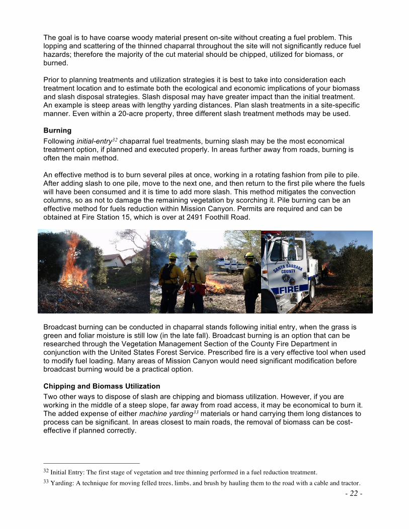
The goal is to have coarse woody material present on-site without creating a fuel problem. This lopping and scattering of the thinned chaparral throughout the site will not significantly reduce fuel hazards; therefore the majority of the cut material should be chipped, utilized for biomass, or burned. Prior to planning treatments and utilization strategies it is best to take into consideration each treatment location and to estimate both the ecological and economic implications of your biomass and slash disposal strategies. Slash disposal may have greater impact than the initial treatment. An example is steep areas with lengthy yarding distances. Plan slash treatments in a site-specific manner. Even within a 20-acre property, three different slash treatment methods may be used. Burning
Following initial-entry32 chaparral fuel treatments, burning slash may be the most economical treatment option, if planned and executed properly. In areas further away from roads, burning is often the main method. An effective method is to burn several piles at once, working in a rotating fashion from pile to pile. After adding slash to one pile, move to the next one, and then return to the first pile where the fuels will have been consumed and it is time to add more slash. This method mitigates the convection columns, so as not to damage the remaining vegetation by scorching it. Pile burning can be an effective method for fuels reduction within Mission Canyon. Permits are required and can be obtained at Fire Station 15, which is over at 2491 Foothill Road. Broadcast burning can be conducted in chaparral stands following initial entry, when the grass is green and foliar moisture is still low (in the late fall). Broadcast burning is an option that can be researched through the Vegetation Management Section of the County Fire Department in conjunction with the United States Forest Service. Prescribed fire is a very effective tool when used to modify fuel loading. Many areas of Mission Canyon would need significant modification before broadcast burning would be a practical option. Chipping and Biomass Utilization
Two other ways to dispose of slash are chipping and biomass utilization. However, if you are working in the middle of a steep slope, far away from road access, it may be economical to burn it. The added expense of either machine yarding33 materials or hand carrying them long distances to process can be significant. In areas closest to main roads, the removal of biomass can be cost-effective if planned correctly.
32 Initial Entry: The first stage of vegetation and tree thinning performed in a fuel reduction treatment.
33 Yarding: A technique for moving felled trees, limbs, and brush by hauling them to the road with a cable and tractor.
- 23 -
You may want to choose areas within 50 feet of a road or landing, preferably on a downhill drag; hand-carrying upslope is extremely time-consuming and should be avoided for obvious reasons. Where material must be dragged, consider that the dragging process “sweeps” the ground of all material, particularly in the haul routes. Because hand labor is usually used on the steepest slopes, the bare earth that this sweeping produces can be a concern. There will be a tradeoff between erosion potential and future germination of local native plants. The site will need to be re-covered with chips, other small material from the site, or with commercial erosion-control products. Chips should not exceed one inch in depth along the surface. Try to limit the areas subjected to sweeping by designating a few haul routes. In general, areas that are not economically feasible for chipping and biomass utilization are usually areas where ecological impacts would increase from activities due to the difficulties of material extraction. In areas that have limited access or are located at mid-slope or on steeper locations, it can be very expensive (both ecologically and economically) to remove or chip treatment slash. Grazing
Grazing with goats is sometimes used to reduce fire hazard and to remove weeds (since they eat them). Grazing under contract with a large herd of goats is a possibility for larger acreages; or one to three goats can be grazed on smaller parcels. In this situation, alternate locations should be arranged for additional grazing when they have eaten all undesirable plants on the site. Goats can be placed on any steepness of slope and can generally graze any shape or size of parcel. However, care should be taken with steep slopes because goats can denude the site, cause loss of important plant populations, and cause significant erosion. Goats can also spread plant seeds in their waste—undesirable when the seeds are from invasive, nonnative, or unwanted species; desirable when the seeds are from desired species. It is important that goat contractors purge the goat herd at their home ranch before bringing them into the canyon. A portion of the $120,000 grant awarded to the Mission Canyon Association from the 2008 USDA Forest Service State Fire Assistance – Los Padres National Forest contained specific funding for the use of goats or sheep for the maintenance of areas modified with previous grant dollars. Because of the challenge of the topography in Mission Canyon, goats have been found to be an excellent vegetation management tool. They were successfully used in 2008-2009 to clear about 25 acres with little risk of erosion. The initial goat grazing allowed hand crews to walk into what had been extremely heavily brushed areas, and cut and move out or pile burn heavier material (trees, trunks, etc.) with minimum surface disruption by the work crew. A large herd of goats for a short period of time was found to most effectively lessen erosion concerns and still have efficient vegetation consumption.
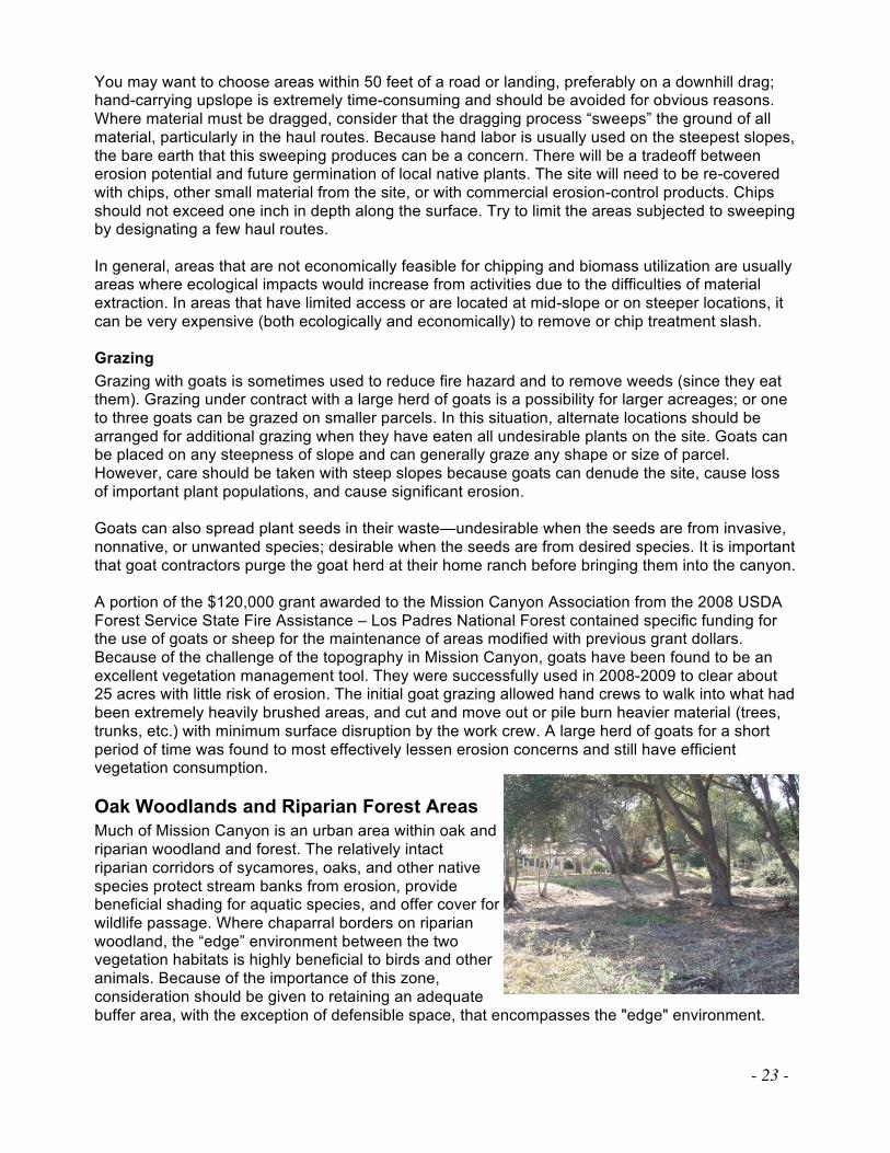
Oak Woodlands and Riparian Forest Areas
Much of Mission Canyon is an urban area within oak and riparian woodland and forest. The relatively intact riparian corridors of sycamores, oaks, and other native species protect stream banks from erosion, provide beneficial shading for aquatic species, and offer cover for wildlife passage. Where chaparral borders on riparian woodland, the “edge” environment between the two vegetation habitats is highly beneficial to birds and other animals. Because of the importance of this zone, consideration should be given to retaining an adequate buffer area, with the exception of defensible space, that encompasses the "edge" environment.
- 24 -
Drainages, creeks, and riparian zones play a role in influencing fire behavior. Many creeks and riparian zones in the Santa Barbara area have undergone changes that can increase the risks of fire. For one, diversion of runoff and instream flows and overdrafting of groundwater can decrease soil moisture within the riparian zone, and this generally results in a decrease in live fuel moistures. Also, volatile nonnative vegetative fuels, such as eucalyptus, have been introduced into the riparian zones. These two factors may result in dangerous conditions and, where appropriate, corrective actions should be considered. Well-maintained creeks and riparian zones will help slow the progress of fire, while desiccated and highly volatile fuels will accelerate fire. The Biological Resources section of the Mission Canyon Community Plan, a draft as of this writing, offers policies and standards for Environmentally Sensitive Habitat (ESH) that must be followed before engaging in vegetation management in these vulnerable areas. For instance, among sensitive habitats are those containing Nuttall’s scrub oak, special status animal (e.g., steelhead critical habitat stream), plant species, or natural communities, and forests of coast live oak, and sycamore and arroyo willow riparian areas. In addition to specific buffer zones to protect stream banks, native trees such as the big leaf maple, white alder, California black walnut, and California bay, to name a few, are protected when 6 inches in diameter at 4.5 feet above ground level. Please refer to the draft Community Plan ESH Overlay map to determine if your property is within or near sensitive habitat. The permit requirements for ESH are in draft form as of this writing; in most instances, typical vegetation management practices for defensible space in ESH will be exempt from the county's permit requirements. However, a Land Use Permit may be required for removing large native trees, removing sensitive vegetation outside of the required defensible space area or for complete removal of riparian vegetation. It is recommended that you consult with County Planning and Development staff if there are any questions about vegetation management in this sensitive habitat.
Risk of Wildfire Occurrence
How wildfire will change the environment in the planning area depends on several factors including the site topography, weather, and condition and type of vegetation and other fuels. Developing an understanding of the environmental conditions in the planning area is the first step in formulating practices or actions that can best modify the environment to improve its fire resiliency.34 The potential for having a catastrophic fire event within the Mission Canyon CWPP Surrounding Areas is a reality. Most recently, the Tea Fire occurred in neighboring Montecito in 2008 and the Jesusita Fire in Mission Canyon itself in 2009. Therefore the measures taken for community survivability must be integrated in governmental planning as well as community action. Knowing the attributes of fire behavior is important in order to communicate the various threats from any fire and the benefits of mitigation. Flame lengths, fire intensity, heat output,35 rate of spread, residence time, and whether the fire burns on the surface or crown are all ways to describe fire behavior and to relate its resistance to control and potential damage or positive impacts from fire. The following paragraphs describe these terms.
Flame Length
Flame length is the span of the flame from the tip to the base, irrespective of its tilt. This factor most influences the probability of structure damage and ease of fire suppression. Flame length is highly correlated with fire intensity, which can help predict fire severity. Flame lengths less than four feet are associated with fires that are more easily controlled—generally with hand crews—and
34 Fire Resiliency: The ability of an ecosystem to maintain its native biodiversity, ecological integrity, and natural
recovery processes following a wildland fire disturbance.
35 Heat Output: The total amount of heat a fire released in a specific area during the passing of the flaming front.
- 25 -
are also associated with widespread low-intensity fires. In contrast, flame lengths longer than12 feet often thwart suppression efforts and are associated with crown fires seen on the front pages. Typically, fuel management goals aim for production of flame lengths less than four feet.
Fire Intensity
Fire intensity describes the amount of heat that is released by flaming combustion in a specific unit of time (BTU/ft/sec). Intensity has a large influence on an ecosystem's recovery from fire. This measurement captures the energy of a fire in any location; it is often confused with fire severity, which is a term describing fire effects.
Fire Severity
Fire severity describes the resulting effects of a fire, based on the amount of soil damage and tree mortality. It is determined by observing vegetation and soil conditions after a fire. The relationship between predicted fire behavior characteristics (flame length, heat per unit area, fire line intensity, etc.) and fire severity are being explored but are not yet well established. Long flame lengths, large amounts of torching, crown fire presence, high fire line intensity, and high heat per unit area are all indicators of potentially severe fires.

- 26 -
Rate of Spread
The rate of spread measures how fast the leading edge36 of a fire advances. A rate of spread faster than fire-line-building capacity will challenge fire suppression efforts. High spread rates also indicate the potential for quick changes in fire spread direction, which could endanger firefighters and increase the potential damages. High rates of spread in grass can exceed 300 feet per minute. Rates of spread in crown fires can exceed 100 feet per minute. A more acceptable rate of spread would be one that is slower than the line-building capacity of fire suppression forces to encircle the fire. Slow-burning fires in forested fuel types spread at a rate of two to eight feet per minute.
Surface Fires
On flat or moderate (<30% slopes) terrain with light fuels, fires usually burn as a surface fire, which may advance quickly with short or long residence time37 and low to high heat output; as such, they respond well to suppression. A manageable fire is one of the desired results of fuel modifications.
Crown Fire Potential
Crowning activity indicates locations where fire is expected to travel into and possibly consume the crowns (or tops) of trees. Crown fires typify a fire of high intensity and exhibit high heat output and rates of spread. These attributes challenge suppression efforts. When a fire burns through tree crowns, countless embers are produced and distributed, sometimes over long distances, which can start new, or spot, fires that can each grow and confound the finest fire-suppression forces. The potential for a crown fire is a reality in the dense olive groves on the upper ends of Mission Canyon as well as the eucalyptus stands located sporadically throughout the community. Crown fire initiation (or torching) occurs when ladder fuels are present, providing a connection between the surface fuels and the crown fuels. The higher the base of the tree canopy from surface fuels, the more difficult it is for crown fires to ignite. Once in the tree canopy, crown fire spread is more likely in dense canopies and with high wind speeds. Stands of eucalyptus and ornamental pines within the Mission Canyon CWPP Surrounding Areas can be a fire concern. Thinning these canopies and modification of their arrangement can offer a decrease in ember production should a fire seat itself in the understory and establish itself into the canopy. Removal of younger, flammable non-native trees and saplings, such as pine, eucalyptus, pepper trees, and juniper, in favor of retaining more fire-resistant natives such as oaks, sycamores, bays, and walnuts, for instance, would also offer a significant cost savings in fuels modification due to the labor and cost involved with removing larger, established trees.
General Wildfire Environment Descriptions
Topography Topographic features such as slope, aspect,38 and the overall form of the land have a profound effect on fire behavior. Topography directly and indirectly affects the intensity, direction, and spread rate of wildfire. Fires burning in flat or gently sloping areas tend to burn more slowly and to spread in a wider ellipse than fires on steep slopes. Streams, rivers, and canyons tend to channel local diurnal39 and general winds, which can accelerate the fire’s speed and affect its direction, especially during Sundowner winds occurring on the south side of the Santa Ynez Mountain Range. Local winds are greatly affected by topography, which “bends the wind” as it flows around
36 Leading Edge: The foremost part of a fire that is guiding the fire in the direction of travel.
37 Residence Time: How long the flaming front burns in any one location.
38 Aspect: The direction that a slope faces (as in north, south, east, or west).
39 Diurnal: Belonging to or active during the day.
- 27 -
or over landforms. Topography also causes daily upslope and down slope winds. The topographic features of aspect and elevation affect vegetation; solar exposure affects fuel moisture.
Weather This section describes common weather conditions and patterns that exist at the time the most damaging fires could occur, along with routine conditions during which serious fires may burn. Weather conditions significantly impact the potential for fire ignition, as well as rates of spread, intensity, and direction in which fires burn. Wind, temperature, and humidity are the more important weather variables used to predict fire behavior.40 The term “fire weather”41 refers to weather elements that influence fire ignition, behavior, and suppression. These elements include temperature, relative humidity, wind speed and direction, precipitation, atmospheric stability, and aloft winds. “General winds” is also an accepted term for local winds produced by broad-scale pressure gradients as shown on synoptic maps and modified by friction or topographic effects. General winds are combined with slope winds to get actual forecasted wind. Wind is considered the most variable and difficult weather element to predict, while wind direction and velocity profoundly affect fire behavior. Wind increases the flammability of fuels by removing moisture through evaporation, preheating fuels in a fire's path, and increasing spotting distances (the distance at which a spot fire might be set by a flying ember). Wind velocities and directions may vary in vertical elevation, with different impacts on fire behavior. Surface winds can directly control the direction and rate at which the fire spreads. Winds that blow at least 20 feet above the ground can carry embers and firebrands downwind, causing spot fires to precede the primary front. Prevailing winds in high fire season (generally June-October) are out of the southwest, although infrequent foehn winds usually blow from the north to the east. Weather conditions can change rapidly as upper-level wind currents and pressure systems in the western states shift locations, and both dry and wet frontal systems move through the mountainous terrain. Frontal winds associated with low-pressure systems moving across the area can create hazardous fire conditions. Winds in advance of the frontal system can reach speeds exceeding 60 mph over ridges. The atmospheric instability dilutes and disperses smoke, but also creates torching (running crown fires are a result of strong winds) and spot fire problems (distances increase as winds increase). Fires during foehn events—or subsiding winds—usually result in extreme fire behavior because the winds are particularly strong and dry, thus preheating fuels and predisposing them to burning with intensity. These conditions are usually worse at night, as these foehn winds combine with up-canyon/down-canyon diurnal winds. Annual highs in Santa Barbara are around 90º Fahrenheit, while lows approach 45º F. In the planning area, annual average highs are around 74º F, while average lows approach 56º F.
40 Husari, S., T. Nichols, N.G. Sugihara, and S.L. Stephens (2006). “Fuel Management.” In: N.G. Sugihara, J. van
Wagtendonk, K.E. Shaffer, J. Fites-Kaufman, and A.E. Thode, editors. Fire in California’s Ecosystems. Berkeley:
University of California Press. Pp. 444–465. 41 Fire Weather: The various types of weather that affect how a fire ignites, behaves, and is controlled.
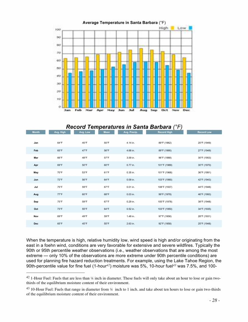
- 28 -
Average Temperature in Santa Barbara (°F)
Record Temperatures in Santa Barbara (°F) Month Avg. High Avg. Low Mean Avg. Precip. Record High Record Low
Jan 64°F 45°F 55°F 4.14 in. 89°F (1962) 20°F (1949)
Feb 65°F 47°F 56°F 4.68 in. 89°F (1995) 27°F (1949)
Mar 66°F 48°F 57°F 3.59 in. 96°F (1988) 30°F (1953)
Apr 69°F 50°F 60°F 0.77 in. 101°F (1989) 30°F (1970)
May 70°F 53°F 61°F 0.35 in. 101°F (1968) 36°F (1991)
Jun 72°F 56°F 64°F 0.09 in. 103°F (1990) 42°F (1943)
Jul 75°F 59°F 67°F 0.01 in. 108°F (1937) 44°F (1948)
Aug 77°F 60°F 68°F 0.03 in. 99°F (1978) 46°F (1993)
Sep 75°F 59°F 67°F 0.29 in. 105°F (1978) 38°F (1948)
Oct 73°F 55°F 64°F 0.52 in. 103°F (1950) 34°F (1935)
Nov 69°F 49°F 59°F 1.48 in. 97°F (1956) 28°F (1931)
Dec 65°F 45°F 55°F 2.63 in. 92°F (1958) 25°F (1948)
When the temperature is high, relative humidity low, wind speed is high and/or originating from the east in a foehn wind, conditions are very favorable for extensive and severe wildfires. Typically the 90th or 95th percentile weather observations (i.e., weather observations that are among the most extreme — only 10% of the observations are more extreme under 90th percentile conditions) are used for planning fire hazard reduction treatments. For example, using the Lake Tahoe Region, the 90th-percentile value for fine fuel (1-hour42) moisture was 5%, 10-hour fuel43 was 7.5%, and 100-
42 1-Hour Fuel: Fuels that are less than ! inch in diameter. These fuels will only take about an hour to lose or gain two-
thirds of the equilibrium moisture content of their environment.
43 10-Hour Fuel: Fuels that range in diameter from ! inch to 1 inch, and take about ten hours to lose or gain two-thirds
of the equilibrium moisture content of their environment.

- 29 -
hour fuel44 was 12.3% when winds blew from the southwest (the prevailing wind direction during fire season). The herbaceous fuel moisture was 67% under these frequencies. The 20-foot wind speed45 was 13.4 miles per hour on the most extreme 10% of the weather days.46 In this example, if the fire season typically lasted 150 days, these values would occur on the 15 most extreme days. Normally the highest values do not occur on the same day (e.g. the hottest days may not coincide with the windiest days). During the 1990 Painted Cave fire Sundowner event, the official Federal Aviation Administration (FAA) observing station at Santa Barbara Airport reported a maximum temperature of 109°F (42.7°C), remarkable for a location on the coastal plain within 2 km of the ocean itself [where the sea surface temperature was approximately 65°F (18.3°C)]. As noted by Ryan and Burch (1992) and Ryan (1994), however, even this wind event pales in comparison to the 17 June 1859 Sundowner. A rather dramatic and colorful description of this event is provided by the following passage taken from the Coast Pilot of California (Davidson 1869).
"The only incident of the “poison wind” on this coast, mentioned either in its history or traditions, was that occurring at Santa Barbara, on Friday, the 17th of June 1859. The temperature during the morning was between 75° and 80°, and gradually and regularly increased until about one o’clock p.m., when a blast of hot air from the northwest swept suddenly over the town and struck the inhabitants with terror. It was quickly followed by others. At two o’clock the thermometer exposed to the air rose to 133°F, and continued at or near that point for nearly three hours, whilst the burning wind raised dense clouds of impalpable dust. No human being could withstand the heat. All betook themselves to their dwellings and carefully closed every door and window. The thick adobe walls would have required days to have become warmed, and were consequently an admirable protection. Calves, rabbits, birds, etc., were killed; trees were blighted; fruit was blasted and fell to the ground, burned only on one side; and gardens were ruined. At five o’clock the thermometer fell to 122°, and at seven it stood at 77°. A fisherman, in the channel in an open boat, came back with his arms badly blistered."
To keep track of fire weather conditions, MCA installed a weather station on Mission Canyon Road, through the help of a Fire Safe Council grant, to provide parameters associated with Red Flag conditions. The information from this weather station is hosted through the UCSB Geography Department, and the data is available to all at zulu.geog.ucsb.edu/VDV/VV_Frame.php. The Santa Barbara Botanic Garden has also placed a RAWS (Remote Automated Weather Station) on one of its hilltops, and that data can be seen here: raws.wrh.noaa.gov/cgi-bin/roman/meso_base.cgi?stn=TT019&unit=0&time=LOCAL. During the Jesusita Fire, which started just west of the Mission Canyon Base Map perimeter on May 5, 2009, but began to rage on the following day, May 6, when by 15:00 hours a Sundowner event had become established, the temperature in Mission Canyon was 98º F, relative humidity 17%, and the wind was gusting up to 43mph, primarily offshore from the northeast, but also occasionally onshore, from the southwest. (Other records describe gale-force winds at times, or 65+mph.) This resulted in a very erratic, gusty wind flow, and the fire was backing and burning through retardant-treated fuels. Rotary-wing aircraft, which had been dumping water, were grounded. Embers were reported starting spot fires one-quarter to one-half mile ahead of the main fire front. The Incident Progression map on the next page demonstrates the speed with which the
44 100-Hour Fuel: Fuels that range from 1 inch to 3 inches and take about 100 hours to lose or gain two-thirds of the
equilibrium moisture content of their environment.
45 20-Foot Wind Speed: The speed of wind, measured 20 feet up, in miles per hour.
46 Information obtained from the Meyers Station near South Lake Tahoe at 6,337 feet elevation during June from 1987
to 1997 (Murphy et al., 2000).
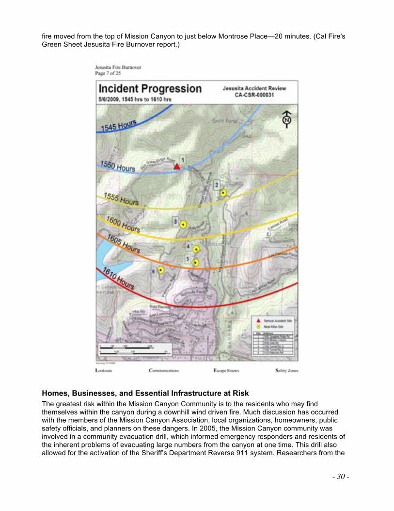
- 30 -
fire moved from the top of Mission Canyon to just below Montrose Place—20 minutes. (Cal Fire's Green Sheet Jesusita Fire Burnover report.)
Homes, Businesses, and Essential Infrastructure at Risk
The greatest risk within the Mission Canyon Community is to the residents who may find themselves within the canyon during a downhill wind driven fire. Much discussion has occurred with the members of the Mission Canyon Association, local organizations, homeowners, public safety officials, and planners on these dangers. In 2005, the Mission Canyon community was involved in a community evacuation drill, which informed emergency responders and residents of the inherent problems of evacuating large numbers from the canyon at one time. This drill also allowed for the activation of the Sheriff’s Department Reverse 911 system. Researchers from the
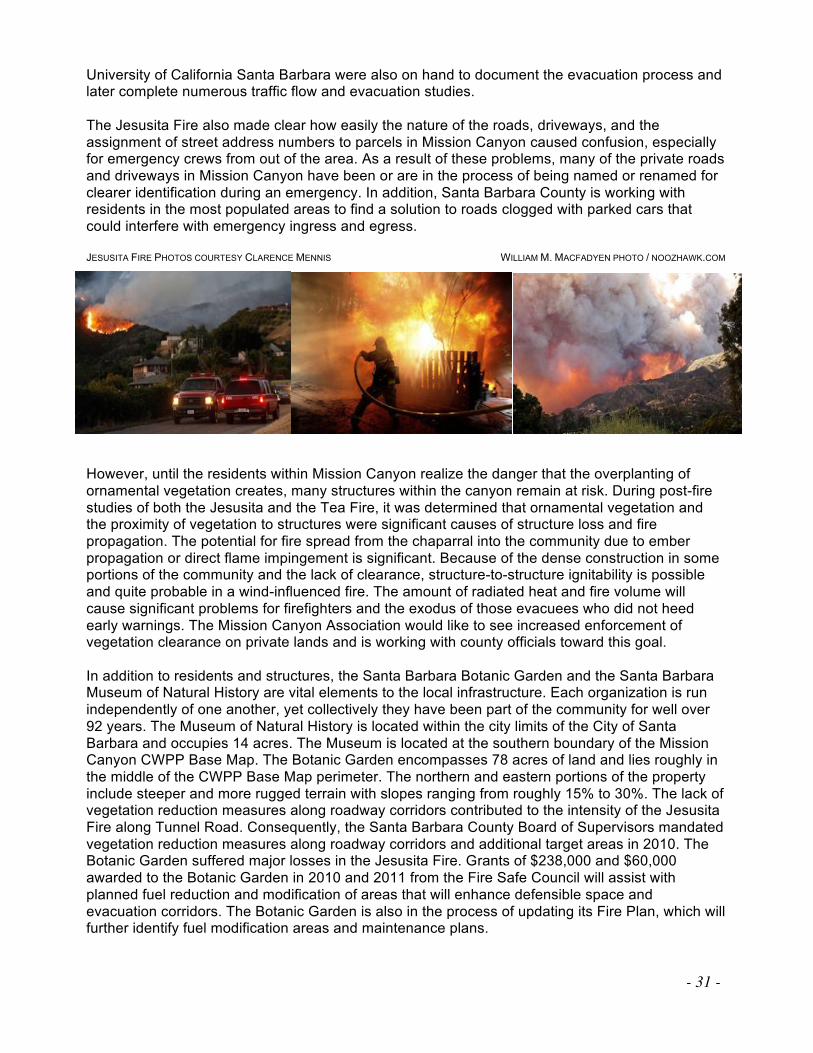
- 31 -
University of California Santa Barbara were also on hand to document the evacuation process and later complete numerous traffic flow and evacuation studies. The Jesusita Fire also made clear how easily the nature of the roads, driveways, and the assignment of street address numbers to parcels in Mission Canyon caused confusion, especially for emergency crews from out of the area. As a result of these problems, many of the private roads and driveways in Mission Canyon have been or are in the process of being named or renamed for clearer identification during an emergency. In addition, Santa Barbara County is working with residents in the most populated areas to find a solution to roads clogged with parked cars that could interfere with emergency ingress and egress. JESUSITA FIRE PHOTOS COURTESY CLARENCE MENNIS WILLIAM M. MACFADYEN PHOTO / NOOZHAWK.COM
However, until the residents within Mission Canyon realize the danger that the overplanting of ornamental vegetation creates, many structures within the canyon remain at risk. During post-fire studies of both the Jesusita and the Tea Fire, it was determined that ornamental vegetation and the proximity of vegetation to structures were significant causes of structure loss and fire propagation. The potential for fire spread from the chaparral into the community due to ember propagation or direct flame impingement is significant. Because of the dense construction in some portions of the community and the lack of clearance, structure-to-structure ignitability is possible and quite probable in a wind-influenced fire. The amount of radiated heat and fire volume will cause significant problems for firefighters and the exodus of those evacuees who did not heed early warnings. The Mission Canyon Association would like to see increased enforcement of vegetation clearance on private lands and is working with county officials toward this goal. In addition to residents and structures, the Santa Barbara Botanic Garden and the Santa Barbara Museum of Natural History are vital elements to the local infrastructure. Each organization is run independently of one another, yet collectively they have been part of the community for well over 92 years. The Museum of Natural History is located within the city limits of the City of Santa Barbara and occupies 14 acres. The Museum is located at the southern boundary of the Mission Canyon CWPP Base Map. The Botanic Garden encompasses 78 acres of land and lies roughly in the middle of the CWPP Base Map perimeter. The northern and eastern portions of the property include steeper and more rugged terrain with slopes ranging from roughly 15% to 30%. The lack of vegetation reduction measures along roadway corridors contributed to the intensity of the Jesusita Fire along Tunnel Road. Consequently, the Santa Barbara County Board of Supervisors mandated vegetation reduction measures along roadway corridors and additional target areas in 2010. The Botanic Garden suffered major losses in the Jesusita Fire. Grants of $238,000 and $60,000 awarded to the Botanic Garden in 2010 and 2011 from the Fire Safe Council will assist with planned fuel reduction and modification of areas that will enhance defensible space and evacuation corridors. The Botanic Garden is also in the process of updating its Fire Plan, which will further identify fuel modification areas and maintenance plans.
- 32 -
Utility corridors are also prevalent in the Mission Canyon Community. Large transmission lines are perched in the foothills above the community, as well as the numerous above-ground power lines that service residences. The Jesusita Fire destroyed all communication equipment along most of Tunnel Road and much of Mission Canyon Road, causing residents to lose service for more than a month in many areas. The County Fire Department works with Southern California Edison to decrease the probability of ignition sources from trees encroaching on the power company’s utilities. The City Water department also has a vast network of tanks, pump stations, and infrastructure that are vulnerable to a catastrophic wildland fire, and, indeed, water shortages were reported by residents during the Jesusita Fire. The City Fire Department ensures clearance measures are maintained on an annual basis on most city property within Mission Canyon.
Local Preparedness and Firefighting Capability
Mission Canyon Fire Protection Agencies and Areas
The following fire protection agencies provide fire protection services to residents in the planning area.
• United States Forest Service, Los Padres National Forest
• Santa Barbara County Fire Department
• CalFire
On land known as a Federal Responsibility Area (FRA), federal agencies have primary responsibility for fire protection. FRAs are defined based on land ownership. Federal agencies such as the USFS have responsibility to provide wildland resource fire protection on all FRA lands in the Mission Canyon CWPP Surrounding Areas. This includes the financial responsibility of preventing and suppressing fires. To more efficiently provide protection over a more contiguous land base, the federal agencies trade protection areas with the California Department of Forestry and Fire Protection (Cal Fire); these lands are balanced within the state. The resulting lands are called State Direct Protection Areas or Federal Direct Protection Areas. The lands that are swapped for the purpose of efficient wildland fire protection in the State of California are reviewed every five years among the signatory parties (USFS, NPS, BLM, and Cal Fire) to what is known as the Cooperative Fire Protection Agreement or the “4-Party Agreement.” State Responsibility Area (SRA) lands are defined based on land ownership, population density, and land use. Cal Fire determines SRA lands per the guidelines established by the State Board of Forestry and Fire Protection. Cal Fire provides wildland resource fire protection on all SRA lands, including the finances for preventing and suppressing fires. Lands in incorporated cities or surrounded by federal land are excluded from SRA lands. Cal Fire does not have responsibility for densely populated areas or agricultural lands. To more efficiently provide protection over a more contiguous land base, Cal Fire swaps protection areas with other agencies, with the resulting lands being called Cal Fire Direct Protection Areas. Within Santa Barbara County, the Santa Barbara County Fire Department, under contract with Cal Fire, provides wildland resource fire protection and prevention efforts on SRA land.
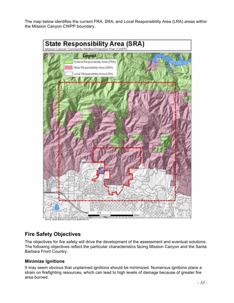
- 33 -
The map below identifies the current FRA, SRA, and Local Responsibility Area (LRA) areas within the Mission Canyon CWPP boundary.
Fire Safety Objectives
The objectives for fire safety will drive the development of the assessment and eventual solutions. The following objectives reflect the particular characteristics facing Mission Canyon and the Santa Barbara Front Country.
Minimize Ignitions
It may seem obvious that unplanned ignitions should be minimized. Numerous ignitions place a strain on firefighting resources, which can lead to high levels of damage because of greater fire area burned.
- 34 -
Decrease Intensity
One factor that disposes structures to fire damage is fire intensity, or the amount of heat transferred to the structure. High-intensity fires also are most likely to produce crown fires47 and torching.48 Embers created from these crown fires are lofted well ahead of the fire front, creating numerous spot fires,49 and they are often the cause of structures burning. The significant down-canyon winds associated with the Santa Barbara front country are a true concern in regard to fire ember spread and fire progression. The level of fire intensity greatly influences the damage to natural resources. Decrease Damage
Fire is part of the natural ecology of Southern California. In contrast, wildfire damage to structures and human improvements needs to be minimized. The natural topography and location of structures within Mission Canyon and the Santa Barbara front country pose many problems for firefighters and residents alike. It is the objective for fire managers to ensure a coordinated evacuation of area residents. This is accomplished through evacuation notifications through the media, door-to-door notification, and the Reverse 911 system. However, fire progression and infrastructure damage could prevent coordinated evacuation notification. It is imperative that citizens make provisions for neighborhood coordination and heed the advice of emergency coordinators to evacuate early. The Mission Canyon Association and Santa Barbara County Fire need to continue efforts to educate residents on evacuation procedures.
Increase Permeability
One ideal is to allow fire to play its natural role without loss. This describes the concept of permeability, whereby fire can spread through a community with minimal negative impact. The perfect situation will be one in which vulnerable resources are protected while fire burns under its normal regime.
Increase Resiliency
The Jesusita Fire was a catastrophic fire affecting the lives of everyone in Mission Canyon. Even with the severity of the fire, evacuation preparedness paid off and not one resident was injured. Most experts agree that the work on vegetation management done in the last three years contributed to a smaller number of homes being lost than was expected, especially in the upper part of the canyon. Because of the tradition of work in fire preparedness by the Mission Canyon Association, the community mobilized immediately to offer tangible support and guidance to all who suffered losses in the fire. In addition, MCA worked with Santa Barbara County Public Works Department, Cachuma Resource Conservation District, Natural Resources Conservation Service, and more than a hundred landowners immediately after the fire to assess and educate on erosion control techniques in anticipation of the winter rains. Cooperative efforts between federal and county governments resulted in the aerial hydromulching of approximately 1,200 acres with an all-organic mix of paper, wood fiber, water, and a binding substance. The mulch slurry was checked to ensure no plastics were inadvertently mixed in. Also, Web-linked cameras were mounted near Mission Creek to allow County Flood Control, USGS, and canyon residents to view water levels and debris remotely. As a result, a year after the fire, the canyon had little post-winter damage, and residents
47 Crown Fire: A fire that spreads from treetop to treetop, and is characteristic of hot fires and dry conditions. Crown
fires are generally more complex to control than fires on the surface.
48 Torching: A rapid and intense burning of a single or small group of trees/shrubs, causing the upward movement of
fire, a.k.a. flare-up.
49 Spot Fire: A smaller fire outside the boundary of the main fire, started by airborne sparks or embers.
- 35 -
were slowly making their way through the rebuilding process. The Mission Canyon Association continues to work for fire preparedness, realizing even more clearly its importance. MCA's view is that another disastrous fire could occur at any moment. Now that the Jesusita Fire has cleared some of the natural and ornamental vegetation, the challenge is to keep the growth under control in those areas. Further, much of the more densely populated areas of the canyon did not burn. To best protect the community, MCA recommends continuing defensible space education along with active enforcement by the fire department. The Mission Canyon community recommends strengthening the tools for enforcement. All new construction in Mission Canyon must meet the current California Building Code Chapter 7A materials and construction methods for exterior wildfire exposure, making homes more fire resistant.
Prioritized Treatments and Goals for Fuels Reduction
The following is an outline of the prioritized hazard reduction recommendations and goals, and preferred treatment methods for hazardous fuels reduction under the Mission Canyon CWPP. Priorities and Goals
With the critical needs assessed for the Mission Canyon area, the stakeholders have identified the following goals to meet the Purpose identified on page 5 of the Mission Canyon CWPP.
! Reduce hazardous fuels on public lands
! Reduce hazardous fuels on private lands (both vacant and occupied)
! Reduce structural vulnerability
! Increase education and awareness of the wildfire threat
! Identify, improve and protect critical evacuation routes
Reduce Hazardous Fuels on Public Lands
Federal lands within the Mission Canyon CWPP Surrounding Areas are managed by the United States Forest Service, and occupy approximately 10,788 acres, or 67%. These figures do not represent that the USFS should be responsible for completing 67% of the vegetation management on these lands, rather it describes land ownership where vegetation treatments would have a positive effect on the Mission Canyon Community and adjoining lands. As can be seen in the aerial imagery below, the steep topography and ridgeline configuration make for a significant management challenge for fire prevention officials. To create fire breaks or manageable fuel reduction zones along the ridgelines on the south-facing slopes of the Santa Ynez Range would pose a significant challenge due to the extremely steep slopes and watershed corridors.
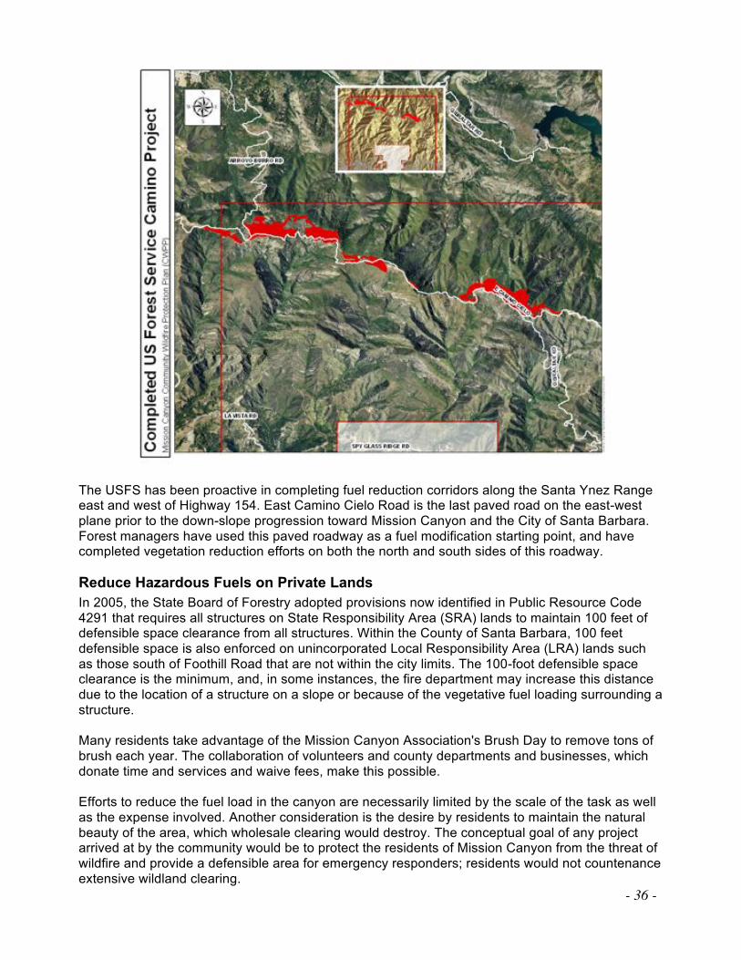
- 36 -
The USFS has been proactive in completing fuel reduction corridors along the Santa Ynez Range east and west of Highway 154. East Camino Cielo Road is the last paved road on the east-west plane prior to the down-slope progression toward Mission Canyon and the City of Santa Barbara. Forest managers have used this paved roadway as a fuel modification starting point, and have completed vegetation reduction efforts on both the north and south sides of this roadway.
Reduce Hazardous Fuels on Private Lands
In 2005, the State Board of Forestry adopted provisions now identified in Public Resource Code 4291 that requires all structures on State Responsibility Area (SRA) lands to maintain 100 feet of defensible space clearance from all structures. Within the County of Santa Barbara, 100 feet defensible space is also enforced on unincorporated Local Responsibility Area (LRA) lands such as those south of Foothill Road that are not within the city limits. The 100-foot defensible space clearance is the minimum, and, in some instances, the fire department may increase this distance due to the location of a structure on a slope or because of the vegetative fuel loading surrounding a structure.
Many residents take advantage of the Mission Canyon Association's Brush Day to remove tons of brush each year. The collaboration of volunteers and county departments and businesses, which donate time and services and waive fees, make this possible. Efforts to reduce the fuel load in the canyon are necessarily limited by the scale of the task as well as the expense involved. Another consideration is the desire by residents to maintain the natural beauty of the area, which wholesale clearing would destroy. The conceptual goal of any project arrived at by the community would be to protect the residents of Mission Canyon from the threat of wildfire and provide a defensible area for emergency responders; residents would not countenance extensive wildland clearing.
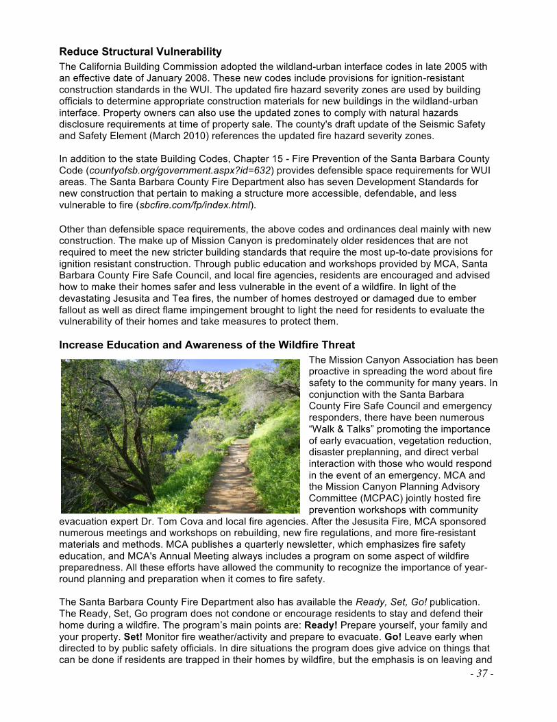
- 37 -
Reduce Structural Vulnerability
The California Building Commission adopted the wildland-urban interface codes in late 2005 with an effective date of January 2008. These new codes include provisions for ignition-resistant construction standards in the WUI. The updated fire hazard severity zones are used by building officials to determine appropriate construction materials for new buildings in the wildland-urban interface. Property owners can also use the updated zones to comply with natural hazards disclosure requirements at time of property sale. The county's draft update of the Seismic Safety and Safety Element (March 2010) references the updated fire hazard severity zones. In addition to the state Building Codes, Chapter 15 - Fire Prevention of the Santa Barbara County Code (countyofsb.org/government.aspx?id=632) provides defensible space requirements for WUI areas. The Santa Barbara County Fire Department also has seven Development Standards for new construction that pertain to making a structure more accessible, defendable, and less vulnerable to fire (sbcfire.com/fp/index.html). Other than defensible space requirements, the above codes and ordinances deal mainly with new construction. The make up of Mission Canyon is predominately older residences that are not required to meet the new stricter building standards that require the most up-to-date provisions for ignition resistant construction. Through public education and workshops provided by MCA, Santa Barbara County Fire Safe Council, and local fire agencies, residents are encouraged and advised how to make their homes safer and less vulnerable in the event of a wildfire. In light of the devastating Jesusita and Tea fires, the number of homes destroyed or damaged due to ember fallout as well as direct flame impingement brought to light the need for residents to evaluate the vulnerability of their homes and take measures to protect them.
Increase Education and Awareness of the Wildfire Threat
The Mission Canyon Association has been proactive in spreading the word about fire safety to the community for many years. In conjunction with the Santa Barbara County Fire Safe Council and emergency responders, there have been numerous “Walk & Talks” promoting the importance of early evacuation, vegetation reduction, disaster preplanning, and direct verbal interaction with those who would respond in the event of an emergency. MCA and the Mission Canyon Planning Advisory Committee (MCPAC) jointly hosted fire prevention workshops with community
evacuation expert Dr. Tom Cova and local fire agencies. After the Jesusita Fire, MCA sponsored numerous meetings and workshops on rebuilding, new fire regulations, and more fire-resistant materials and methods. MCA publishes a quarterly newsletter, which emphasizes fire safety education, and MCA's Annual Meeting always includes a program on some aspect of wildfire preparedness. All these efforts have allowed the community to recognize the importance of year-round planning and preparation when it comes to fire safety. The Santa Barbara County Fire Department also has available the Ready, Set, Go! publication. The Ready, Set, Go program does not condone or encourage residents to stay and defend their home during a wildfire. The program’s main points are: Ready! Prepare yourself, your family and your property. Set! Monitor fire weather/activity and prepare to evacuate. Go! Leave early when directed to by public safety officials. In dire situations the program does give advice on things that can be done if residents are trapped in their homes by wildfire, but the emphasis is on leaving and
- 38 -
leaving early. These are critical elements for the public to address and understand prior to a wildland fire event. The document is available at sbcfire.com.
Identify, Improve and Protect Critical Evacuation Routes
The majority of the public road infrastructure within Mission Canyon and the adjoining communities were built before current standards for width, setbacks, and the proper traffic flow for the ingress or egress of vehicles or emergency equipment were adopted. The 2005 evacuation drill highlighted many of the areas that could pose potential problems for the continuous flow of traffic in the event of a significant area evacuation. In light of this information, many roadway issues have been addressed in the draft Mission Canyon Community Plan. Among those issues, the inadequacy of Foothill Road as an egress for the multitude of residents dependent on this roadway to lead them to safe refuge was partially addressed by the California Department of Transportation Foothill Road improvement project, which was completed in 2010. A more efficient, covered drainage system replaced the open ditches along Foothill from Cheltenham Road to shortly before Tye Road. This created a wider road and allowed for designated parking spaces thus greatly improving the area's main east-west evacuation thoroughfare. Among other identified recommendations are enhancements in the number, size, and frequency of vehicle pull outs along the shoulders of Foothill, Mission Canyon, Tunnel, Las Canoas, and Cheltenham roads. The Mission Canyon Association recommends considering both city and county right of ways for the development of these pull outs, and if not available, homeowners could be approached to allow for access on private property. The County is working with homeowners to find solutions to the parking problem in Mission Canyon Heights that clogs principal evacuation routes. Painting fog lines, white lines that demarcate the edge of the legally drivable portion, has been suggested as a means to clearly indicate legal parking. In 2006 and 2007, California Fire Safe Council grant dollars were used to decrease the amount of vegetation encroaching on many of the vital roadways needed for evacuation purposes. Along with these measures, continuous improvement by private landowners to clear ornamental vegetation would keep it from encroaching into the road right of way. MCA urges homeowners to monitor this encroachment and not wait for notification from governmental agencies to clear overgrown vegetation that impedes passage or impairs sight at driveways or intersections. The draft Community Plan identifies the following essential evacuation roadways as in need of right-of-way encroachment removal:
" Mission Canyon Road " Tunnel Road " Foothill Road
" Cheltenham Road " Tye Road
Treatments and Goals
1. Hazardous Fuel Reduction Along Evacuation Routes
Recommendation: Hazardous fuel reduction along evacuation corridors in coordination with landowners. Rationale: Roadways located within the CWPP Boundary form the evacuation corridors for Mission Canyon residents. Vegetation management of annual grasses and low-growing tree limbs is needed to keep the roads passable to both evacuees and emergency vehicles. 2. Hazardous Fuel Reduction at Tunnel Trailhead
Recommendation: Hazardous fuel reduction at Tunnel Trailhead in coordination with adjacent landowners.
- 39 -
Rationale: Much of this area burned in the recent Jesusita Fire, but retains dead vegetation that is capable of reburning. Moreover, given the favorable environmental conditions, vegetation is rapidly regrowing. The risk of wildfire and danger to the community is therefore not eliminated in this area.
3. Hazardous Fuel Reduction at Holly Road area
Recommendation: Hazardous fuel reduction at Holly Road areas in coordination with adjacent landowners. Rationale: Much of this area burned in the recent Jesusita Fire, but retains dead vegetation that is capable of reburning. Moreover, given the favorable environmental conditions, vegetation is rapidly regrowing. The risk of wildfire and danger to the community is therefore not eliminated in this area.
4. Hazardous Fuel Reduction in Olive Orchard Areas
Recommendation: Hazardous fuel reduction among olive orchards along Mission Canyon Road in coordination with landowners. Rationale: Much of this area burned in the recent Jesusita Fire, but the olive trees are all regrowing vigorously. Also, the orchards retain dead vegetation that is capable of reburning. The risk of wildfire and danger to the community is therefore not eliminated in this area.
5. Education and Outreach
Recommendation: Education and outreach efforts in all CWPP areas to inform residents and visitors of fire issues regarding spaces, structures, vegetation, roads, etc. Rationale: Much progress in understanding of fire issues and community awareness has been developed among residents through Mission Canyon Association's education efforts over the past decade. This positive progress forms the foundation of the community's understanding of and work toward fuels, structural, and ornamentals modifications.
Funding Sources
Consistent funding opportunities have been a topic of discussion with the Mission Canyon Association and its members for some time. Grant funding opportunities from state and federal sources have allowed the MCA to complete multiple projects since 2000. However, these grant opportunities and funding sources fluctuate year to year, and do not allow for a systematic or sustainable approach for project completion and maintenance due to the funding uncertainty. One method described in the draft Mission Canyon Community Plan (Action FIRE-MC-1.1, Section 3 Fire Protection Goals, Policies, Development Standards and Actions) is the feasibility of developing a Mission Canyon Wildland Fire Suppression Assessment District. Initial discussions are being held at the county and city level. Mission Canyon has an existing assessment district for sewer services, and a fire assessment can be added to this Community Service Area (CSA) 12. Further studies must be carried out before this can come to a vote, including the amount of the assessment for each lot or parcel for the initial fiscal year, the establishment of a budget and plan for services to reduce the severity and damage from wildland fires (the “Services”) that would be funded by the proposed assessment, and the determination of the benefits received from the Services by property within the proposed Assessment District. The Mission Canyon Association is actively exploring the feasibility of an assessment district with Santa Barbara County. At the same time, MCA will continue to apply for grants in order to continue the important work of vegetation management.
Implementation and Maintenance
The Mission Canyon Association, in conjunction with the Santa Barbara County Fire Department and Santa Barbara County Fire Safe Council, has been proactive in completing projects to enhance evacuation routes and fuel modification areas with grant funding since 2000. In 2007 and
- 40 -
2008, additional partnerships were created with MCA and private landowners to enhance and create additional fuel modification areas on the upper private lands adjacent to Mission Canyon and Tunnel roads. Additional fuel reduction zones were established with private landowners along the Spyglass Ridge corridor. The Jesusita Fire eliminated vegetation in much of Mission Canyon, especially the upper areas along Spyglass Ridge, Holly, Tunnel, and Mission Canyon roads. After the fire, the remaining grant money was used to do additional road clearance in Mission Canyon Heights, which escaped the fire but contains serious hazards. One of the goals now is to take advantage of the fire and this small window of opportunity and work hard to keep the vegetation at reduced levels in areas most critical to fire safety for the entire canyon. Mission Canyon Association is encouraging homeowners to replant with fire safety in mind and continues to work to educate those who escaped the fire to reduce and maintain the vegetation on their property.
Organizational Responsibilities
Mission Canyon Association
• Continue to explore funding sources for vegetation management projects
• Act as conduit for information transfer to community in regard to fuel modification projects and related fire safety concerns
• Establish dialogue with landowners to facilitate partnerships in fuel modification projects that act as a benefit to the community
• Assist in the identification of community based projects that meet MCA and Fire Department needs
• Participate and attend meetings of the Santa Barbara County Fire Safe Council
• Update the Mission Canyon CWPP
Santa Barbara County Fire Department
• Coordinate with MCA, governmental agencies and homeowners to develop fuel modification projects
• Enforce Defensible Space laws (PRC 4291) and complete annual inspections
• Develop project boundaries that may meet criteria for Natural Resources Conservation Service (NRCS) funding and work with contractors to complete projects
• Santa Barbara County assist with updating of the Mission Canyon CWPP
Sustaining the MC-CWPP and Vegetation Management Projects
The first Mission Canyon CWPP was completed in November 2008; the revision of the current draft version was completed in May 2011 and is based on current conditions and best available information. As new practices in fuels modification and community safety occur, the CWPP will continue to need to be updated to remain current with accepted standards. In addition, as the needs of the community and the Fire Department change, modifications are recommended to keep the CWPP current in order to represent the views of the community. The plan should be reviewed as new project areas are identified and as project progress requires preservation to avoid deterioration. Copies of this plan will be available on the Mission Canyon Association website or upon request and at the Vegetation Management Program offices of the Santa Barbara County Fire Department.
- 41 -
Areas to Retain and Revisit
Keeping completed project areas safe from fire is of the utmost concern of the Mission Canyon Association, the Mission Canyon Community, and fire agencies. Retention methods will vary depending on project scope and vegetation types. The need for revisiting project areas is ongoing, and a properly maintained fuel modification area will offer the greatest defense against fire intrusion and it will also offer the most cost-effective method of preserving the time and effort put forth to develop zones of vegetation reduction.
Updating the Mission Canyon CWPP
The Mission Canyon CWPP is a working document for the community, the Mission Canyon Association, and governmental agencies. It is a project derived from the opinions and recommendations of the members of the Mission Canyon community and other interested parties, with direction and input from fire agencies and professional researchers in the field of fire mitigation and prevention. This document will need to be updated periodically when new project locations are identified or the needs of the community adjust as conditions within the community change. This document may serve to inspire the community to continue to be a part of their fire safety preparedness.