Embed Size (px)
Citation preview

-MODULE 1-
INTEGRATED LAND-USE PLANNING LAW
- CONTEXT & CONCEPTS -
PRACTICAL EXERCISE OUTLINE
Identifying Land-Use Planning Tools and their Legal Status/Role, Institutions, Overlaps and Synergies
Nature
Small Group Exercise.
Fictional Legal Case Study. Legal Problem Solving. Small Group Feedback.
Structured Class Discussion.
Purpose Provide Learners with an opportunity to reflect on their knowledge of the law in a
practical/fictional context.
Increase Learners’ ability to identify and understand: o Relevant land-use planning tools.
o Relevant laws governing these land-use planning tools. o Legal status and role of these land-use planning tools. o Institutions responsible for administering these land-use planning tools.
o Overlaps between these land-use planning tools. Prepare Learners for Module 2 in which the above aspects will be discussed in
more detail. Structure
Introduction to the Practical Exercise (30 minutes). Small Group Work (120 minutes).
Group Presentations (60 minutes). Class Discussion (30 minutes).
Method Divided Leaners into five equal groups.
Provide each group with a copy of the following documents: o Case Study Narrative and Questions (Annexure A) – one for each Learner. o Map of the Case Study Area (Annexure B) – one for each Learner.
o Answer Template (Blank) (Annexure C) – couple for each group. Copies of the Answer Template (Blank) should ideally be pre-printed
or pre-drawn on large A0 sheets of paper.

Introduction to the Practical Exercise - (30 minutes) o Explain the nature and purpose of the Practical Exercise.
o Briefly introduce the Case Study. o Highlight that the Practical Exercise is based on a fictional case study with
a view to ensuring that it remains universally relevant and contemporary
to everyone. o Introduce the Task:
Read carefully through the Case Study as a group. Each group must discuss the following five questions:
What land-use planning tools are mentioned in the context of
the Case Study? What laws govern each of these land-use planning tools?
What is the legal status and role of each of these land-use planning tools?
o Are they informative - provide information that decision makers must/may take into account in their decision making (for example when considering any
application for a permit/licence/ permission/ authorisation/consent)?
o Are they prescriptive – do they create binding rights and obligations for landowners and trigger permitting processes (for example they require the landowner to
apply for some form of permit/ licence/consent/permission/authorisation to do certain
things on their property)? Which institutions are responsible for administering each of
these land-use planning tools?
Are there any overlaps between the different land-use planning tools?
Each group should capture their answers on the blank A0 Answer Templates provided to them.
Each group will be given 12 minutes to present the outcomes of
their discussion to the class and in preparation for this: Each group should appoint a scribe.
Each group should appoint a spokesperson. Each group has 120 minutes to prepare their responses.
Group Work (120 minutes) o During this time the groups will complete the above task.
o You should rotate yourself equitably between the groups with a view to answering queries and facilitating discussion.
o An example of a completed Answer Template is contained in Annexure D –
to enable you to assist the groups with queries and guide them in their deliberations.
Group Presentations (60 minutes)
o The groups will then come together as a class and the spokesperson of
each group will be given 12 minutes to present the outcome of their discussion on each of the aspects they were tasked to consider.
o Provide an opportunity/space for each group to stick up their work. o Be sure to hold each spokesperson to their allotted time.
o Should groups struggle/you think they may struggle to cover all aspects during their allotted time, you may:
Task each group in advance to canvas all issues in their discussion but only present on one issue to the class.
Ask subsequent group spokespersons to simply highlight possible
additions or alternative responses/approaches to those presented by previous groups – rather than repeating them.
o The trainer should facilitate this process and encourage feedback and additions from other groups during the group presentations to ensure that the session is interactive and participatory.
o The completed Answer Template (Annexure D) should assist you in facilitating this process.
Class Discussion (30 minutes)
o Start by highlighting the complexity and diversity of land-use planning tools, laws and institutions that are mentioned in the Case Study.
o Emphasise that while fictional, the Case Study largely mimics reality in
many countries. o Identify the possibility of grouping the different land-use planning tools by
scale, institution, nature, legal role/purpose. o Highlight the major conflicts/overlaps and talk about possible mechanisms
for overcoming these during both the formulation and implementation of
the different land-use planning tools. o You may then wish to briefly present the pre-prepared complete Answer
Template (Annexure D) to the Learners. o This can be done by either projecting the complete Answer Template onto
a screen or handing out a hardcopy of the complete Answer Template to
each of the Learners and working through it systematically.
Resources Case Study Narrative and Questions (Annexure A) Map of the Case Study Area (Annexure B)
Answer Template – Blank (Annexure C) Answer Template – Complete (Annexure D)
ANNEXURE A – CASE STUDY NARRATIVE
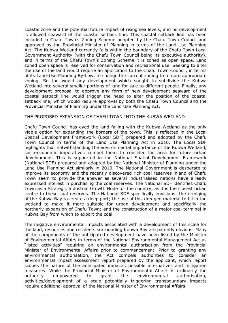
THE BROAD CONTEXT Kubwa Bay is situated on the boundary between two countries, West Kubwa Republic
in the west and East Kubwa Republic in the east. The boundary between the two countries is demarcated by the Kubwa River. The Kubwa River originates in the
interior and passes through a pristine mountainous landscape of high biological value before flowing into Kubwa Bay. Where the Kubwa River meets the coast, it forms a large wetland delta known as the Kubwa Wetland. Chafu Town situated in West
Kubwa Republic and specifically the Kubwa River Province, is located to the south-west of Kubwa Bay. Asili Village situated in East Kubwa Republic is located on the
peninsular to the north-east of Kubwa Bay. Kubwa Bay is shallow, fringed by coral reefs, and forms a vital breeding ground for many fish species.
THE PROTECTED AREAS
In recognition of the need and value of protecting the pristine mountainous landscape spanning the border of both countries and through which the Kubwa River
flows, the Presidents of West Kubwa Republic and East Kubwa Republic, operating in terms of powers accorded to them in terms of their respective countries’ Constitutions, concluded a Memorandum of Understanding (MOU) to establish the
Kubwa River Transboundary Conservation Area (KRTCA) in 2000. In terms of this MOU, the countries agreed to: formally demarcate specific territory on both sides of
the Kubwa River as protected areas; establish domestic management institutions for each of the protected areas which would then in turn sit on a joint management board for the KRTCA; and develop management plans for each of the protected
areas which would then in turn inform the development of a joint management plan for the KRTCA. In fulfilment of these obligations, the following has occurred since the
signing of the MOU: West Kubwa National Park (WKNP) – West Kubwa Republic
o The National Minister of the Environment established the WKNP in 2005 in terms of the National Parks Act.
o The land situated in the WKNP is state-owned, and therefore the National Minister of Public Works, who oversees the use of all state-owned land, formally consented to the inclusion of the land within the boundaries of the
Park. o The National Parks Authority (established in terms of the National Parks Act
to oversee national parks) was appointed to manage the WKNP. o The National Parks Authority developed and oversee the implementation of
a Management Plan for the WKNP which precludes any form of industrial or
urban development within the boundary of the protected area.
East Kubwa Protected Landscape (EKPL) – East Kubwa Republic o The National Minister of Nature Conservation established the EKPL in 2005
in terms of the Nature Conservation Act.
o The land situated in the EKPL is held under communal title by the Asili Community. They have for centuries inhabited the area and now
predominately reside in Asili Village. They live a largely subsistence lifestyle comprising of fishing and small-scale agriculture. The National Minister of
Nature Conservation consulted with the Asili Community who formally

consented to the inclusion of their land within the EKPL by way of a protected area agreement concluded with the National Minister of Nature
Conservation in terms of the Nature Conservation Act. This protected area agreement set out the rights and obligations of the parties to it in relation to the EKPL, and contained a condition that the Asili Community could
continue to reside and harvest natural resources to support their subsistence lifestyle within the protected area.
o A Management Committee comprising of representatives from the Department of Nature Conservation (that has the mandate to manage protected areas established under the Nature Conservation Act) and the
Asili Community, was appointed to manage the EKPL. o The Management Committee developed and oversee the implementation of
a Management Plan for the EKPL.
Kubwa River Transboundary Conservation Area (KRTCA) o West Kubwa National Park and the East Kubwa Protected Landscape fall
within the boundary of the KRTCA.
o A Joint Management Board comprising of representatives from the National Parks Authority (WKNP) and the Management Committee (EKPL) was
established to coordinate management of the KRTCA in 2010. o The Joint Management Board prepared a Joint Management Plan to inform
and coordinate the management of the KRTCA. It includes reference to the
need to retain the Kubwa Wetland, which currently falls outside the formal boundary of the WKNP for reasons outlined below, as a key buffer to the
south of the KRTCA. THE KUBWA WETLAND
Where the Kubwa River meets the coast, it forms a large wetland delta (the Kubwa
Wetland) which is the seasonal home for several migratory bird species and other threatened plant, fish and animal species. The Kubwa Wetland serves three additional important ecological functions. Firstly, it purifies the waters of the Kubwa
River that are increasingly polluted by coal mining activities undertaken inland. Extensive coal deposits were found inland five years ago on the western bank of the
Kubwa River and several small coal mining operations have been established there. Secondly, it slows down the floodwaters of the Kubwa River in the rainy season which would otherwise threaten the residents of the two settlements situated
adjacent to Kubwa Bay, namely Chafu Town and Asili Village. Annual rainfall has significantly increased in the area and scientists have attributed this to climate
change. Thirdly, it forms a vital buffer between the WKNP and Chafu Town to the south of it. Ideally, the Kubwa Wetland should have been included within the boundary of the WKNP. The land is however communally owned by the Sekta
Community who historically refused to agree to its inclusion in the WKNP for fear of the extensive and perpetual limitations this would create for their future potential
use or sale of the area. At the time the WKNP was established, the Sekta Community had indicated to representatives from the West Kubwa Government that they were prepared to sell the land to them at market value or for the Government to
expropriate the land subject to compensation, but the Government indicated that it did not have the resources available to do so in the interests of conservation.
Following these discussions, the Sekta Community concluded a 99 year conservation agreement in 2005 with the National Parks Authority in terms of the National Parks
Act. The National Parks Act enables any landowner to conclude such an agreement

with the National Parks Authority. The conservation agreement covers the land comprising of the Kubwa Wetland, and the terms thereof have been registered
against the title deed of the property under the Land Act by the Registrar of Deeds. The conservation agreement provides that: the Sekta Community will not use or develop the land; the National Parks Authority will manage the land for conservation
purposes; the National Parks Authority will pay the Sekta Community a small monthly ‘rental’ for foregoing their use and development rights over the land; and
either party can on two year’s notice to the other withdraw from the agreement. The Kubwa Wetland, which comprises predominantly of swampy marshland, remains undeveloped and is managed by the National Parks Authority as a buffer zone to the
WKNP.
ENVIRONMENTAL PLANS
The area falling within both the Kubwa Wetland and the adjacent WKNP have been listed as a threatened ecosystem by the National Minister of the Environment in terms of the Biodiversity Act. The significance of this listing means that any proposed
development in the listed area triggers the need for an environmental authorisation issued by the Provincial Minister of the Environment in terms of the National
Environmental Management Act. Any application for an environmental authorisation must in terms of the Act be preceded by a comprehensive environmental impact assessment (EIA) undertaken by the developer with the results being submitted to
the Provincial Minister of the Environmental together with the application for the environmental authorisation. The same area has also been declared as a strategic
water resource area by the National Minister of Water Affairs under the Water Act. A water resource management plan which advocates strongly against development in the area, has been published by the same Minister to inform water management in
the area. While the Water Act does not preclude development within strategic water resource areas, it compels all authorities when considering applications for
environmental authorisations in such areas, to consult with the authority who prepared the water resource management plan and take into account the content of any such plan. Finally, the land comprising the Kubwa Wetland is currently covered
by a coastal management plan prepared by the Provincial Environmental Department in terms of the Integrated Coastal Management Act. The content and legal status of
this coastal management plan largely matches that of the water resource management plan.
CHAFU TOWN
Situated just south of the Kubwa Wetland is Chafu Town, a medium-sized settlement situated on the small coastal plain. It currently falls within the jurisdiction of the Chafu Local Government Authority which is governed by the Chafu Town Council.
Originally comprising of a small fishing village, Chafu Town has expanded rapidly into a flourishing fishing centre, serviced by a small fishing harbour. The population of
the town has grown significantly and the Chafu Town Council is desperately exploring options to expand the urban edge of the town to accommodate its many new inhabitants. This has proven a great challenge as Chafu Town is bounded: to the
west by a steep mountainous landscape which geographical precludes expansion in this direction; to the north by the Kubwa Wetland; and to the east by the open
ocean and Kubwa Bay. In terms of the Integrated Coastal Management Act, a 10 metre coastal setback line has been demarcated by the Provincial Environmental
Department to mitigate the negative impact of development adjacent to the sensitive
coastal zone and the potential future impact of rising sea levels, and no development is allowed seaward of the coastal setback line. This coastal setback line has been
included in Chafu Town’s Zoning Scheme adopted by the Chafu Town Council and approved by the Provincial Minister of Planning in terms of the Land Use Planning Act. The Kubwa Wetland currently falls within the boundary of the Chafu Town Local
Government Authority (with the Chafu Town Council being its executive authority), and in terms of the Chafu Town’s Zoning Scheme it is zoned as open space. Land
zoned open space is reserved for conservation and recreational use. Seeking to alter the use of the land would require an application to the Chafu Town Council, in terms of its Land-Use Planning By-Law, to change the current zoning to a more appropriate
zoning. So too would any development which sought to subdivide the Kubwa Wetland into several smaller portions of land for sale to different people. Finally, any
development proposal to approve any form of new development seaward of the coastal setback line would trigger the need to alter the position of the coastal
setback line, which would require approval by both the Chafu Town Council and the Provincial Minister of Planning under the Land Use Planning Act.
THE PROPOSED EXPANSION OF CHAFU TOWN INTO THE KUBWA WETLAND
Chafu Town Council has eyed the land falling with the Kubwa Wetland as the only viable option for expanding the borders of the town. This is reflected in the Local Spatial Development Framework (Local SDF) prepared and adopted by the Chafu
Town Council in terms of the Land Use Planning Act in 2010. The Local SDF highlights that notwithstanding the environmental importance of the Kubwa Wetland,
socio-economic imperatives compel them to consider the area for future urban development. This is supported in the National Spatial Development Framework (National SDF) prepared and adopted by the National Minister of Planning under the
Land Use Planning Act similarly in 2010. The National Government is desperate to improve its economy and the recently discovered rich coal reserves inland of Chafu
Town seem to provide the answer as several industrialised nations have already expressed interest in purchasing the coal reserves. The National SDF identifies Chafu Town as a Strategic Industrial Growth Node for the country, as it is the closest urban
centre to these coal reserves. The National SDF specifically envisions: the dredging of the Kubwa Bay to create a deep port; the use of this dredged material to fill in the
wetland to make it more suitable for urban development and specifically the northerly expansion of Chafu Town; and the construction of a major coal terminal in Kubwa Bay from which to export the coal.
The negative environmental impacts associated with a development of this scale for
the land, resources and residents surrounding Kubwa Bay are patently obvious. Many of the components of the anticipated development have been listed by the Minister of Environmental Affairs in terms of the National Environmental Management Act as
“listed activities” requiring an environmental authorisation from the Provincial Minister of Environmental Affairs prior to commencement. Prior to granting any
environmental authorisation, the Act compels authorities to consider an environmental impact assessment report prepared by the applicant, which report scopes the nature of the anticipated impacts, possible alternatives and mitigation
measures. While the Provincial Minister of Environmental Affairs is ordinarily the authority empowered to grant the environmental authorisation,
activities/development of a scale potentially triggering transboundary impacts require additional approval of the National Minister of Environmental Affairs.

Preliminary discussions are had with the Sekta Community with the proposal being for the Minister of Land Affairs to expropriate (compulsorily acquire) the land in
terms of the Expropriation Act. The National Government has funding specifically earmarked to enable this process as it relates to the creation of a Strategic Industrial Growth Node reflected in the National SDF. The contents of the National SDF and
Local SDF are clearly at odds with several environmental plans prepared by the national and provincial environmental authorities relevant to the Kubwa Wetland
(these are mentioned above). They are also at odds with the Provincial Spatial Development Framework (Provincial SDF) developed by the Provincial Minister of Planning under the Land Use Planning Act in 2010. The Provincial SDF highlights the
importance of retaining the current footprint of Chafu Town as is, given the significant ecological services provided by the Kubwa Wetland to the residents living
adjacent to Kubwa Bay. The Land Use Planning Act provides that all SDFs adopted under it should be consistent with other relevant planning frameworks and all
authorities must take their content into account in their decision making whether at a national, provincial or local scale. The Land Use Planning Act also prescribes a set of Planning Principles that all authorities must take into account when considering
land development applications, defined to include all applications relating to permissions to develop or change the current use of land. These Planning Principles
include the: principle of spatial justice (land development decisions must provide equitable benefits to all inhabitants of an area); principle of spatial sustainability (land development decisions must seek to promote the integration of social,
economic and environmental considerations); principle of good and efficiency administration (land development decisions must be effective, efficient, participatory,
transparent and accountable); and the principle of spatial resilience (land development decisions must acknowledge the need for flexibility to adapt to changing circumstances).
YOUR TASK
Having read through the above Narrative carefully and consulted the Map, prepare your responses to each of the following four questions:
1. What land-use planning tools are mentioned in the Case Study?
2. What laws govern each of these land-use planning tools? 3. What is the legal status and role of each of these land-use planning tools?
a. Are they informative - provide information that decision makers must/may
take into account in their decision making (for example when considering any application for a permit/licence/permission/consent/ authorisation)?
b. Are they prescriptive – do they create binding rights and obligations for landowners and trigger permitting processes (for example they require the landowner to apply for some form of a permit/licence/permission/
consent/authorisation to do certain things on their property)? 4. Which government institutions are responsible for administering each of these
land-use planning tools? 5. Are there any overlaps between the different land-use planning tools?
Use the Answer Templates provided to capture your responses.
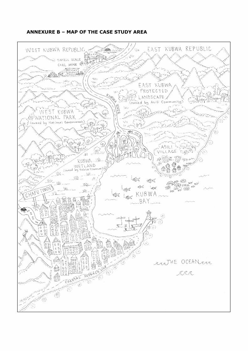
ANNEXURE B – MAP OF THE CASE STUDY AREA
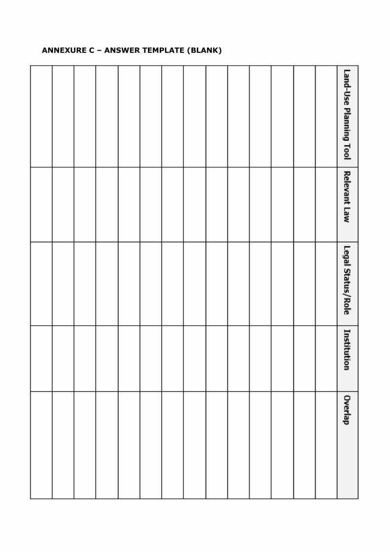
ANNEXURE C – ANSWER TEMPLATE (BLANK)

ANNEXURE D – ANSWER TEMPLATE (COMPLETE)
Land-Use Planning Tool
Relevant Law Legal Status/Role Institution Overlap
Memorandum of Understanding (KRTCA)
Constitution of West Kubwa Republic & Constitution of East Kubwa Republic (that enabled the Presidents to conclude the Memorandum of Understanding)
Prescriptive (creates binding obligations on the two countries)
Presidents of West Kubwa Republic and East Kubwa Republic (signed the Memorandum of Understanding)
All planning tools applicable to the area falling within KRTCA.
Establishment of Transboundary Protected Area (KRTCA)
Constitution of West Kubwa Republic & Constitution of East Kubwa Republic (that enabled the Presidents to conclude the Memorandum of Understanding to establish the area)
Prescriptive (creates binding obligations on the two countries)
Presidents of West Kubwa Republic and East Kubwa Republic (signed the Memorandum of Understanding)
All planning tools applicable to the area falling within KRTCA.
Establishment of Protected Area (WKNP)
National Parks Act Prescriptive (declaration of area as a protected area imposes restrictions on activities/types of development within the protected area’s border)
Minister of the Environment (formally declared area) Minister of Public Works (state-owned land so had to give consent)
All planning tools applicable to the area falling within WKNP.
Management Plan (WKNP)
National Parks Act Informative (informs all decision making undertaken by the management authority for the WKNP)
National Parks Authority (appointed as the management authority of the WKNP and must develop and implement the management plan)
All planning tools applicable to the area falling within WKNP.
Establishment of Protected Area (EKPL)
Nature Conservation Act
Prescriptive (declaration of area as a protected area imposes restrictions on activities/types of development within the protected area’s border)
National Minister of Nature Conservation (formally declared area)
All planning tools applicable to the area falling within EKPL.
Protected Area Agreement (EKPL)
Nature Conservation Act
Prescriptive (the agreement sets out the rights and obligations of parties to the agreement)
National Minister of Nature Conservation & the Asili Community (both parties to the agreement)
All planning tools applicable to area falling within EKPL.
Management Plan (EKPL)
Nature Conservation Act
Informative (informs all decision making undertaken by the Management Committee for the EKPL)
Management Committee with representatives from Department of Nature Conservation and the Asili Community (appointed as the management authority of the EKPL and must develop and implement the management plan)
All planning tools applicable to the area falling within EKPL.

Joint Management Plan (KRTCA)
Constitution of West Kubwa Republic & Constitution of East Kubwa Republic (that enabled the Presidents to conclude the Memorandum of Understanding to establish the transboundary protected area and produce the Joint Management Plan)
Informative (informs all decision making undertaken by the Joint Management Board for the KRTCA)
Joint Management Board of the KRTCA comprising of representatives from the National Parks Authority (WKNP) and the Management Committee (EKPL) (appointed as the management authority of the KRTCA and must develop and implement the joint management plan)
All planning tools applicable to the area falling within KRTCA.
Conservation Agreement (Kubwa Wetland)
National Parks Act Prescriptive (the conservation agreement sets out the rights and obligations of both parties)
National Parks Authority & the Sekta Community (both are parties to the agreement) National Parks Authority (responsible for managing the Kubwa Wetland in terms of the agreement)
All planning tools applicable to the area falling within Kubwa Wetland.
Title Deed Condition (Kubwa Wetland)
Land Act Prescriptive (the title deed conditions are recorded in the property’s title deed that sets out the rights and obligations of the landowner – the Sekta Community)
Registrar of Deeds (responsible for registering the conditions against the title deed)
All planning tools applicable to the area falling within Kubwa Wetland.
Listed Ecosystem (Kubwa Wetland and WKNP)
Biodiversity Act Prescriptive (the listing of the area as a threatened ecosystem triggers certain permitting obligations)
National Minister of the Environment (listed the area as a threatened ecosystem)
All planning tools applicable to the area falling within Kubwa Wetland and WKNP.
EIA & Environmental Authorisation (Listed Ecosystem - Kubwa Wetland and WKNP)
National Environmental Management Act
Prescriptive (creates the obligation to undertake an EIA and obtain an environmental authorisation)
Provincial Minister of the Environment (responsible for considering the EIA and deciding whether or not to grant an environmental authorisation)
All planning tools applicable to the area falling within the listed ecosystem – namely Kubwa Wetland and WKNP.
Declaration of Strategic Water Resource Area (Kubwa Wetland
and WKNP)
Water Act Prescriptive (established the strategic water resource area and
imposes obligations on authorities when considering applications for environmental authorisations in respect of activities undertaken within the strategic water resource area)
National Minister of Water Affairs (declared the area as a strategic water resource
area)
All planning tools applicable to the area falling within the strategic water
resource area – namely Kubwa Wetland and WKNP.

Water Resource Management Plan (Kubwa Wetland and WKNP)
Water Act Informative (informs all decision making regarding applications for environmental authorisations under the National Environmental Management Act)
National Minister of Water Affairs (prepared and published the water resource management plan) Provincial Minister of the Environment (compelled to consider the water resource management plan when deciding whether or not to grant an environmental authorisation)
All planning tools applicable to the area falling within the strategic water resource area – namely Kubwa Wetland and WKNP.
Coastal Management Plan (Kubwa Wetland)
Integrated Coastal Management Act
Informative (informs all decision making regarding applications for environmental authorisations under the National Environmental Management Act)
Provincial Environmental Department (prepared and published the water resource management plan) Provincial Minister of the Environment (compelled to consider the water resource management plan when deciding whether or not to grant an environmental authorisation)
All planning tools applicable to the area falling within Kubwa Wetland.
Demarcation of Coastal Setback Line (Chafu Town - including Kubwa Wetland which falls within its jurisdictional border)
Integrated Coastal Management Act Land Use Planning Act
Prescriptive (prohibits development seaward of the line)
Provincial Enviro Department (demarcated the coastal setback line in terms of the Integrated Coastal Management Act) Provincial Minister of Planning (approved the inclusion of the coastal setback line in the Zoning
Scheme in terms of the Land Use Planning Act) Chafu Town Council (included the coastal setback line in the Zoning Scheme prepared and adopted in terms of the Land Use Planning Act)
All planning tools applicable to the area falling within the Chafu Town’s jurisdictional border – which includes the Kubwa Wetland.
Creation of Zoning Scheme (Chafu Town - including Kubwa Wetland which falls within its jurisdictional border)
Land Use Planning Act
Prescriptive (prescribes landowners’ land-use rights and obligations)
Chafu Town Council (prepared and adopted the Zoning Scheme) Provincial Minister of Planning (approved the Zoning Scheme)
All planning tools applicable to the area falling within the Chafu Town’s jurisdictional border – which includes the Kubwa Wetland.
Open Space Zoning (Kubwa Wetland)
Land Use Planning Act Zoning Scheme
Prescriptive (prescribes landowners land-use rights and obligations)
Chafu Town Council (prepared and adopted the Zoning Scheme) Provincial Minister of Planning (approved the Zoning Scheme)
All planning tools applicable to the area falling within the Kubwa Wetland.
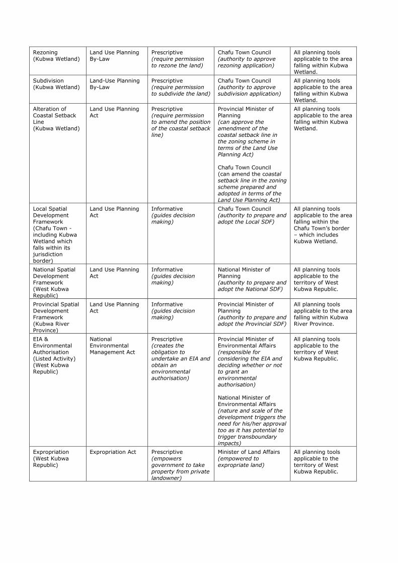
Rezoning (Kubwa Wetland)
Land Use Planning By-Law
Prescriptive (require permission to rezone the land)
Chafu Town Council (authority to approve rezoning application)
All planning tools applicable to the area falling within Kubwa Wetland.
Subdivision (Kubwa Wetland)
Land-Use Planning By-Law
Prescriptive (require permission to subdivide the land)
Chafu Town Council (authority to approve subdivision application)
All planning tools applicable to the area falling within Kubwa Wetland.
Alteration of Coastal Setback Line (Kubwa Wetland)
Land Use Planning Act
Prescriptive (require permission to amend the position of the coastal setback line)
Provincial Minister of Planning (can approve the amendment of the coastal setback line in the zoning scheme in terms of the Land Use Planning Act) Chafu Town Council (can amend the coastal setback line in the zoning scheme prepared and adopted in terms of the Land Use Planning Act)
All planning tools applicable to the area falling within Kubwa Wetland.
Local Spatial Development Framework (Chafu Town - including Kubwa Wetland which falls within its jurisdiction border)
Land Use Planning Act
Informative (guides decision making)
Chafu Town Council (authority to prepare and adopt the Local SDF)
All planning tools applicable to the area falling within the Chafu Town’s border – which includes Kubwa Wetland.
National Spatial Development Framework (West Kubwa Republic)
Land Use Planning Act
Informative (guides decision making)
National Minister of Planning (authority to prepare and adopt the National SDF)
All planning tools applicable to the territory of West Kubwa Republic.
Provincial Spatial Development Framework (Kubwa River Province)
Land Use Planning Act
Informative (guides decision making)
Provincial Minister of Planning (authority to prepare and adopt the Provincial SDF)
All planning tools applicable to the area falling within Kubwa River Province.
EIA & Environmental Authorisation (Listed Activity) (West Kubwa Republic)
National Environmental Management Act
Prescriptive (creates the obligation to undertake an EIA and obtain an environmental authorisation)
Provincial Minister of Environmental Affairs (responsible for considering the EIA and deciding whether or not to grant an environmental authorisation) National Minister of Environmental Affairs (nature and scale of the development triggers the need for his/her approval too as it has potential to
trigger transboundary impacts)
All planning tools applicable to the territory of West Kubwa Republic.
Expropriation
(West Kubwa Republic)
Expropriation Act Prescriptive
(empowers government to take property from private landowner)
Minister of Land Affairs
(empowered to expropriate land)
All planning tools
applicable to the territory of West Kubwa Republic.

Planning Principles (West Kubwa Republic)
Land Use Planning Act
Informative (informs all decisions made under the Act)
All Planning Authorities (compelled to take into account when considering land development applications, defined to include all applications relating to permissions to develop or change the current use of land)
All planning tools applicable to the territory of West Kubwa Republic.