Embed Size (px)
Citation preview
Modulhandbuch
zum Studiengang
Master of Science
Institut für Geologie, Mineralogie und Geophysik
Anlage zum
Reakkreditierungsantrag der Ruhr-Universität Bochum

1
1. Handbucheinleitung .............................................................................................................................. 3
1.1. Beratung (Advice) ........................................................................................................................... 5
1.2. Studienplan (Plan of studies) ......................................................................................................... 5
2. Modulbeschreibungen........................................................................................................................... 7
Applied geophysics I .......................................................................................................................... 9
Applied geophysics II ....................................................................................................................... 10
Geophysical methods ........................................................................................................................ 12
Geophysical practical ........................................................................................................................ 14
Physics of the solid earth I ................................................................................................................ 15
Physics of the solid earth II ............................................................................................................. 16
Angewandte Hydrogeologie ............................................................................................................. 18
Applied geothermal energy ............................................................................................................. 20
GIS in hydrogeology ........................................................................................................................ 22
Groundwater hydraulics ...................................................................................................................23
Hydrogeochemische Methoden .......................................................................................................25
Drilling engineering 1 – Geotechnical and near-surface drilling .................................................. 27
Field Courses in applied geology .................................................................................................... 28
Hydrochemistry................................................................................................................................ 30
Hydrogeologische Geländemethoden ............................................................................................. 31
Siedlungswasserwirtschaft ...............................................................................................................32
Earthquake processes ........................................................................................................................ 33
Earthquakes seminar and data analysis ........................................................................................... 35
Reservoir and fault geomechanics ................................................................................................... 37
Mapping active faults ....................................................................................................................... 39
Seismotectonics and seismic hazard ............................................................................................... 41
Felsmechanik und Felsbau .............................................................................................................. 43
Spezielle Ingenieurgeologie ............................................................................................................ 45
Kristallchemie................................................................................................................................... 46
Synthese und Kristallisation ............................................................................................................ 48
Kristallphysik .................................................................................................................................... 50
Festkörperspektroskopie ...................................................................................................................52
Strukturbestimmung ....................................................................................................................... 54
Analytical methods in rock analysis ................................................................................................ 56
Electron beam microanalysis............................................................................................................ 57
Field course in petrology ................................................................................................................. 59
2
Igneous petrology .............................................................................................................................60
Kinetics ............................................................................................................................................. 62
Metamorphic petrology .................................................................................................................... 64
Thermodynamics ............................................................................................................................ 66
Field course in tectonics and resources .......................................................................................... 68
Economic geology II ....................................................................................................................... 69
Economic geology I .......................................................................................................................... 70
Advanced sedimentology .................................................................................................................. 73
Sedimentäre Geochemie / Sedimentary geochemistry .................................................................. 75
Sedimentäre Geologie im Gelände ................................................................................................. 77
Structural geology ............................................................................................................................ 79
Complementary module: Geology and geohazards in an active subduction zone ....................... 81
3
1. Handbucheinleitung
(Introduction to the Handbook)

4
Handbucheinleitung Geowissenschaften, MSc
5
This module handbook summarizes the plan of organization and essential contents of the MSc curriculum in Geosciences at the Institut für Geologie, Mineralogie und Geophysik of the Ruhr Universität Bochum. This handbook outlines the modularization concept of the curriculum and provides information on places where advice is available at the planning stage, as well as during your studies. The core of the handbook consists of description of modules that are currently on offer.
1.1. Beratung (Advice)
Fachberater (Advisor): Before the start of your studies you have to schedule an advisory meeting with a Professor of your choice (your Fachberater / advisor) at the Institut für Geologie, Mineralogie und Geophysik. During this meeting, depending on the interests that you want to pursue, a complete study plan including the selection of modules is set up by mutual agreement. The plan is submitted to the examination committee for approval and constitutes a binding agreement. It may be changed once during the first year if desired. Further changes are possible under unavoidable circumstances (e.g. a course on the plan is not offered for some reason). Your Fachberater (advisor) would typically become your MSc thesis advisor as well, but this is not required – it is possible to change your advisor during the course of your studies.
The Institut für Geologie, Mineralogie und Geophysik is committed to barrier-free learning. In order to offset disadvantages, the Institut offers individualized alternative plans for measurement of all kinds of performance to students with documented needs.
Prüfungsausschuss (Examination committee): Should you have questions or problems that you cannot resolve with your advisor, members of the examination committee or the Chair of the examination committee are the persons to turn to.
Fachschaft (Student association): You can always seek tips, help and advice from your senior cohorts at the student association.
1.2. Studienplan (Plan of studies)
The plan of study is fully flexible and is set up individually for each student through discussions with the advisor (see above) at the beginning of the study program.

Handbucheinleitung Geowissenschaften, MSc
6
7
2. Modulbeschreibungen
(Module descriptions)

8
Applied geophysics I Geowissenschaften, MSc
9
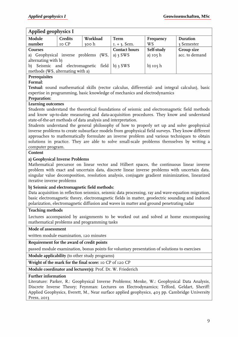
Applied geophysics I
Module number
Credits 10 CP
Workload 300 h
Term 1. + 3. Sem.
Frequency WS
Duration 3 Semester
Courses a) Geophysical inverse problems (WS, alternating with b) b) Seismic and electromagnetic field methods (WS, alternating with a)
Contact hours a) 3 SWS b) 3 SWS
Self-study a) 105 h b) 105 h
Group size acc. to demand
Prerequisites Formal: Textual: sound mathematical skills (vector calculus, differential- and integral calculus), basic expertise in programming, basic knowledge of mechanics and electrodynamics Preparation:
Learning outcomes Students understand the theoretical foundations of seismic and electromagnetic field methods and know up-to-date measuring and data-acquisition procedures. They know and understand state-of-the-art methods of data analysis and interpretation. Students understand the general philosophy of how to properly set up and solve geophysical inverse problems to create subsurface models from geophysical field surveys. They know different approaches to mathematically formulate an inverse problem and various techniques to obtain solutions in practice. They are able to solve small-scale problems themselves by writing a computer program.
Content
a) Geophysical Inverse Problems Mathematical precursor on linear vector and Hilbert spaces, the continuous linear inverse problem with exact and uncertain data, discrete linear inverse problems with uncertain data, singular value decomposition, resolution analysis, conjugate gradient minimization, linearized iterative inverse problems
b) Seismic and electromagnetic field methods: Data acquisition in reflection seismics, seismic data processing, ray and wave-equation migration, basic electromagnetic theory, electromagnetic fields in matter, geoelectric sounding and induced polarization, electromagnetic diffusion and waves in matter and ground penetrating radar
Teaching methods
Lectures accompanied by assignments to be worked out and solved at home encompassing mathematical problems and programming tasks
Mode of assessment
written module examination, 120 minutes
Requirement for the award of credit points
passed module examination, bonus points for voluntary presentation of solutions to exercises
Module applicability (to other study programs)
Weight of the mark for the final score: 10 CP of 120 CP
Module coordinator and lecturer(s): Prof. Dr. W. Friederich
Further information Literature: Parker, R.: Geophysical Inverse Problems; Menke, W.: Geophysical Data Analysis, Discrete Inverse Theory; Feynman: Lectures on Electrodynamics; Telford, Geldart, Sheriff: Applied Geophysics, Everett, M., Near surface applied geophysics, 403 pp. Cambridge University Press, 2013
Applied geophysics II Geowissenschaften, MSc
10
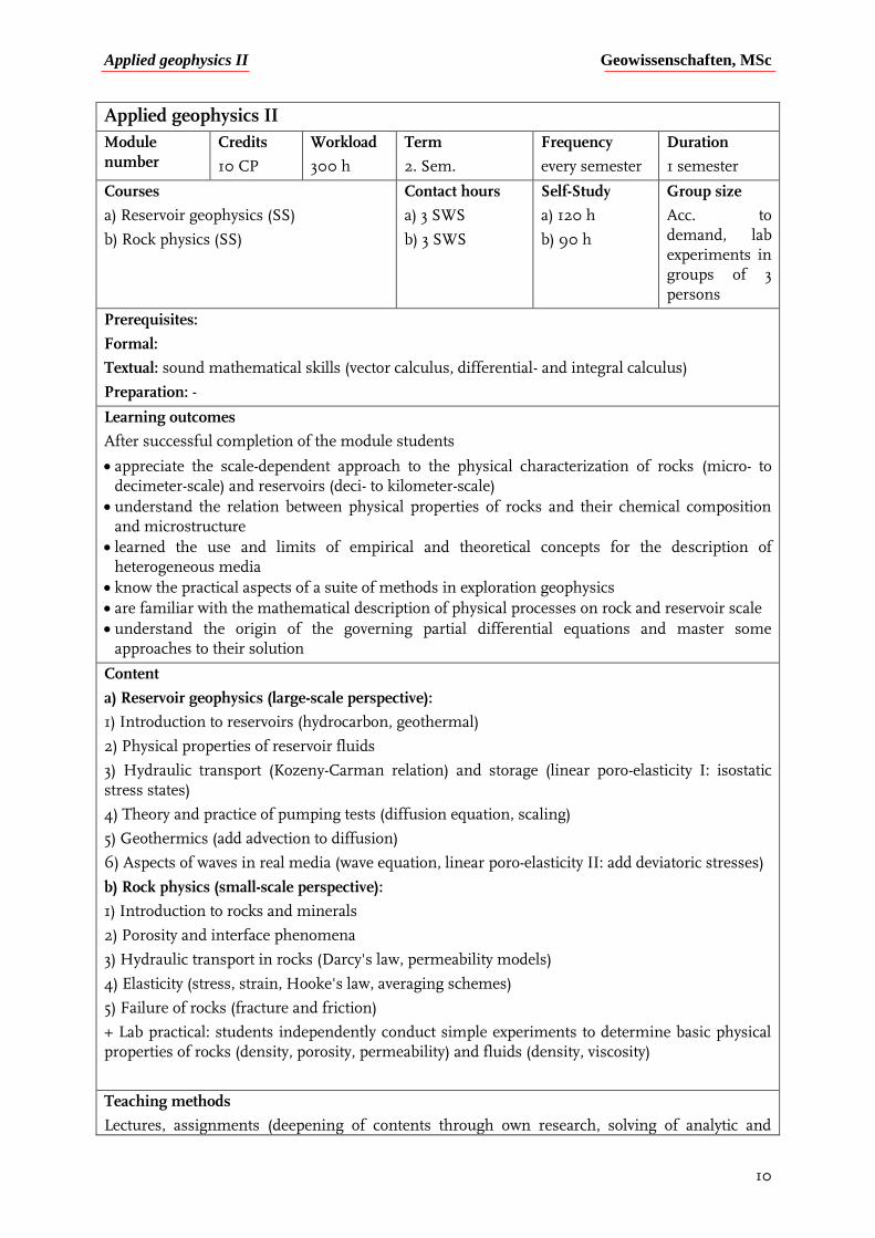
Applied geophysics II
Module number
Credits
10 CP
Workload
300 h
Term
2. Sem.
Frequency
every semester
Duration
1 semester
Courses
a) Reservoir geophysics (SS)
b) Rock physics (SS)
Contact hours
a) 3 SWS
b) 3 SWS
Self-Study
a) 120 h
b) 90 h
Group size
Acc. to demand, lab experiments in groups of 3 persons
Prerequisites:
Formal:
Textual: sound mathematical skills (vector calculus, differential- and integral calculus)
Preparation: -
Learning outcomes
After successful completion of the module students
appreciate the scale-dependent approach to the physical characterization of rocks (micro- to decimeter-scale) and reservoirs (deci- to kilometer-scale)
understand the relation between physical properties of rocks and their chemical composition and microstructure
learned the use and limits of empirical and theoretical concepts for the description of heterogeneous media
know the practical aspects of a suite of methods in exploration geophysics
are familiar with the mathematical description of physical processes on rock and reservoir scale
understand the origin of the governing partial differential equations and master some approaches to their solution
Content
a) Reservoir geophysics (large-scale perspective):
1) Introduction to reservoirs (hydrocarbon, geothermal)
2) Physical properties of reservoir fluids
3) Hydraulic transport (Kozeny-Carman relation) and storage (linear poro-elasticity I: isostatic stress states)
4) Theory and practice of pumping tests (diffusion equation, scaling)
5) Geothermics (add advection to diffusion)
6) Aspects of waves in real media (wave equation, linear poro-elasticity II: add deviatoric stresses)
b) Rock physics (small-scale perspective):
1) Introduction to rocks and minerals
2) Porosity and interface phenomena
3) Hydraulic transport in rocks (Darcy's law, permeability models)
4) Elasticity (stress, strain, Hooke's law, averaging schemes)
5) Failure of rocks (fracture and friction)
+ Lab practical: students independently conduct simple experiments to determine basic physical properties of rocks (density, porosity, permeability) and fluids (density, viscosity)
Teaching methods
Lectures, assignments (deepening of contents through own research, solving of analytic and
Applied geophysics II Geowissenschaften, MSc
11
numerical problems), laboratory experiments
Mode of assessment
Written final exam (3 hours), report on lab experiments
Requirements for the award of credit points
Passed module exam (at least 50%)
Module applicability (to other study programs)
Weight of the mark for the final score: 10 CP of 120 CP
Module coordinator and lecturer(s): Prof. Dr. Jörg Renner (coordinator)
Further information:
Literature: Jaeger, Cook, Zimmerman “Fundamentals of Rock Mechanics”; Gueguen, Palciauskas “Introduction to the physics of rocks“; Schön “Physical properties of rocks“; Mavko, Mukerji, Dvorkin “The rock physics handbook“; AGU reference shelf “Rock physics and phase relations“; Sully “Elements of petroleum geology”; Wang “Theory of linear poro-elasticity”; Fetter “Applied hydrogeology”; Zoback “Reservoir geomechanics”; Carcione “Wave-fields in real media”
Geophysical methods Geowissenschaften, MSc
12
Geophysical methods
Module
number
Credits
14 CP
Workload
420 h
Term
1. Sem.
Frequency
WS
Duration
3 Semester
Courses
a) Field practical
b) Scientific programming
c) Geophysical seminar
Contact hours
a) 6d field, 4d data analysis
b) 3 SWS
c) 4 SWS
Self-Study
a) 70h
b) 105 h
c) 60 h
Group size
a) 16
b) and c) accor-ding to demand
Prerequisites
Formal:
Textual: basic programming experience
Preparation: Field-practical guide, Python online documentation and tutorials, Metcalf, M.: Fortran 95/2003 explained, selected scientific papers
Learning outcomes
After successful completion of the module, students
are able to plan and setup a field campaign, choose appropriate methods and instruments, carry out measurements and use available techniques to analyse the data when given a geophysical survey task.
gained proficiency in a programming language (either Python or Fortran) to the extent that they can exploit advanced concepts, such as object-oriented programming, and thus are able to write programs to analyse data acquired in the field, numerically solve geophysical problems, and visualize the results.
learned how to perform general and topical literature surveys and how to perform an exegesis of a scientific publication.
applied their acquired knowledge and skills to understand and also summarize publications from different fields of geophysics.
Content
a) Field practical:
Students plan and organize a geophysical field campaign to investigate a specific subsurface target using a specifically selected combination of geophysical survey methods, such as seismics, magnetics, geoelectrics, ground penetrating radar or gravimetry. Data are acquired in the field and analysed in the class-room using state-of-the-art techniques. Programming skills are employed to prepare and organize data and to visualize results for further interpretation.
b) Scientific programming:
Data types, assignments, mathematical operations and functions, input/output, characters and strings, arrays and loops, conditional statements, subroutines and functions, modules, derived data types, polymorphic types and classes. Application of concepts to geophysical problems. Programming Language: Python.
c) Geophysical Seminar:
Literature seminar about a specific geophysical topic where students read and work through selected publications to later report to their fellow students on the contents in a seminar. The student presenters take on the role of moderators during the subsequent discussion of the papers and their presentations.
Teaching methods Field work, group and project work, oral presentations
Geophysical methods Geowissenschaften, MSc
13
Mode of assessment Report for field practical, evaluation of written programs, oral presentations and attendance in seminar
Requirement for the award of credit points
Passed report, submission of programming work, and oral presentation
Module applicability (to other study programs)
Weight of the mark for the final score: 14 CP of 120 CP
Module coordinator and lecturer(s): Prof. Dr. Friederich (Coordinator), Prof. Dr. Renner
Further information
Literature: Python online documentation and tutorials, Metcalf, M.: Fortran 95/2003 explained
Geophysical practical Geowissenschaften, MSc
14
Geophysical practical
Module number
Credits
5 CP
Workload
150 h
Term
1., 2. or 3.
Frequency
every semester
Duration
1 semester
Courses Contact hours
20 days
Self-Study
Group size
Prerequisites:
Formal: none
Textual: none
Preparation:
Learning outcomes
After successful completion of the module
Students are able to tackle and master a defined task in a timely and organized way
Content
Theoretical and practical tasks related to research activities of the institute’s working groups or of companies
Teaching methods
Team work, project work
Mode of assessment
Report
Requirements for the award of credit points
Assessment of a written report by the advisor
Module applicability (to other study programs)
Weight of the mark for the final score: 5 CP of 120 CP
Module coordinator and lecturer(s): Prof. Dr. Friederich, Prof. Dr. Renner
Further information
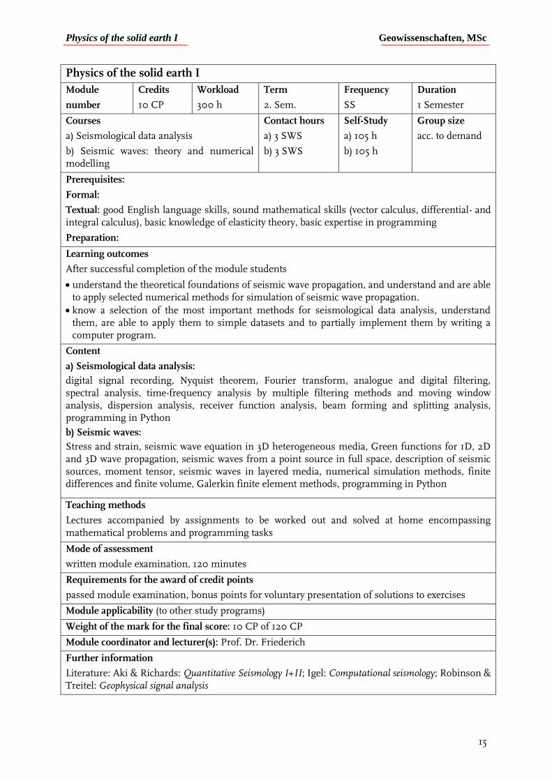
Physics of the solid earth I Geowissenschaften, MSc
15
Physics of the solid earth I
Module
number
Credits
10 CP
Workload
300 h
Term
2. Sem.
Frequency
SS
Duration
1 Semester
Courses
a) Seismological data analysis
b) Seismic waves: theory and numerical modelling
Contact hours
a) 3 SWS
b) 3 SWS
Self-Study
a) 105 h
b) 105 h
Group size
acc. to demand
Prerequisites:
Formal:
Textual: good English language skills, sound mathematical skills (vector calculus, differential- and integral calculus), basic knowledge of elasticity theory, basic expertise in programming
Preparation:
Learning outcomes
After successful completion of the module students
understand the theoretical foundations of seismic wave propagation, and understand and are able to apply selected numerical methods for simulation of seismic wave propagation.
know a selection of the most important methods for seismological data analysis, understand them, are able to apply them to simple datasets and to partially implement them by writing a computer program.
Content
a) Seismological data analysis:
digital signal recording, Nyquist theorem, Fourier transform, analogue and digital filtering, spectral analysis, time-frequency analysis by multiple filtering methods and moving window analysis, dispersion analysis, receiver function analysis, beam forming and splitting analysis, programming in Python
b) Seismic waves:
Stress and strain, seismic wave equation in 3D heterogeneous media, Green functions for 1D, 2D and 3D wave propagation, seismic waves from a point source in full space, description of seismic sources, moment tensor, seismic waves in layered media, numerical simulation methods, finite differences and finite volume, Galerkin finite element methods, programming in Python
Teaching methods
Lectures accompanied by assignments to be worked out and solved at home encompassing mathematical problems and programming tasks
Mode of assessment
written module examination, 120 minutes
Requirements for the award of credit points
passed module examination, bonus points for voluntary presentation of solutions to exercises
Module applicability (to other study programs)
Weight of the mark for the final score: 10 CP of 120 CP
Module coordinator and lecturer(s): Prof. Dr. Friederich
Further information
Literature: Aki & Richards: Quantitative Seismology I+II; Igel: Computational seismology; Robinson & Treitel: Geophysical signal analysis
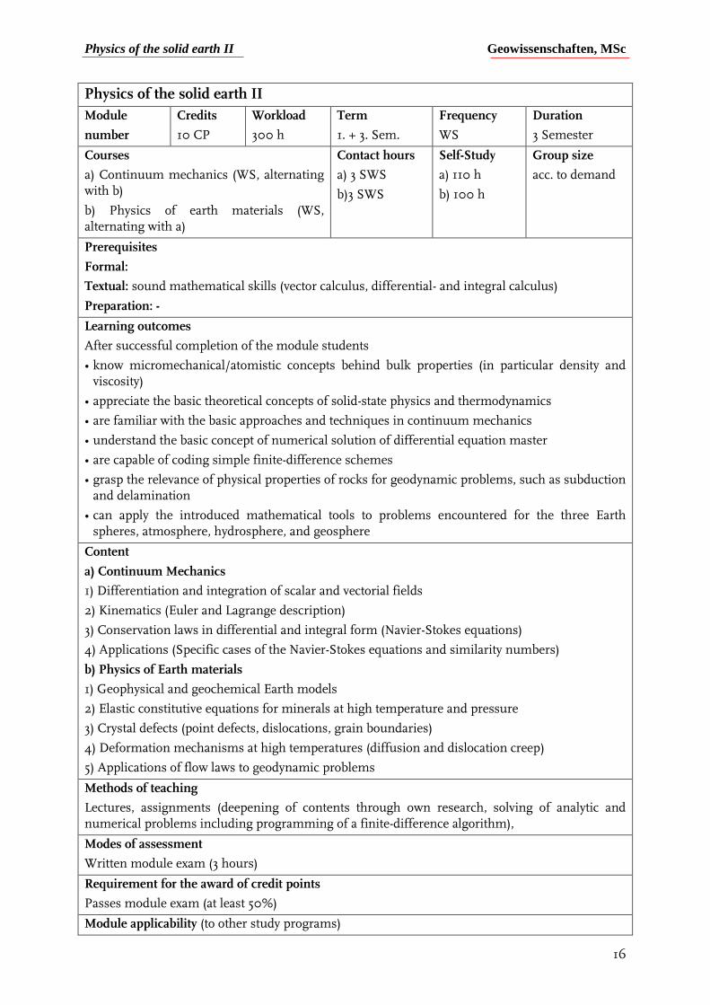
Physics of the solid earth II Geowissenschaften, MSc
16
Physics of the solid earth II
Module
number
Credits
10 CP
Workload
300 h
Term
1. + 3. Sem.
Frequency
WS
Duration
3 Semester
Courses
a) Continuum mechanics (WS, alternating with b)
b) Physics of earth materials (WS, alternating with a)
Contact hours
a) 3 SWS
b)3 SWS
Self-Study
a) 110 h
b) 100 h
Group size
acc. to demand
Prerequisites
Formal:
Textual: sound mathematical skills (vector calculus, differential- and integral calculus)
Preparation: -
Learning outcomes
After successful completion of the module students
• know micromechanical/atomistic concepts behind bulk properties (in particular density and viscosity)
• appreciate the basic theoretical concepts of solid-state physics and thermodynamics
• are familiar with the basic approaches and techniques in continuum mechanics
• understand the basic concept of numerical solution of differential equation master
• are capable of coding simple finite-difference schemes
• grasp the relevance of physical properties of rocks for geodynamic problems, such as subduction and delamination
• can apply the introduced mathematical tools to problems encountered for the three Earth spheres, atmosphere, hydrosphere, and geosphere
Content
a) Continuum Mechanics
1) Differentiation and integration of scalar and vectorial fields
2) Kinematics (Euler and Lagrange description)
3) Conservation laws in differential and integral form (Navier-Stokes equations)
4) Applications (Specific cases of the Navier-Stokes equations and similarity numbers)
b) Physics of Earth materials
1) Geophysical and geochemical Earth models
2) Elastic constitutive equations for minerals at high temperature and pressure
3) Crystal defects (point defects, dislocations, grain boundaries)
4) Deformation mechanisms at high temperatures (diffusion and dislocation creep)
5) Applications of flow laws to geodynamic problems
Methods of teaching
Lectures, assignments (deepening of contents through own research, solving of analytic and numerical problems including programming of a finite-difference algorithm),
Modes of assessment
Written module exam (3 hours)
Requirement for the award of credit points
Passes module exam (at least 50%)
Module applicability (to other study programs)
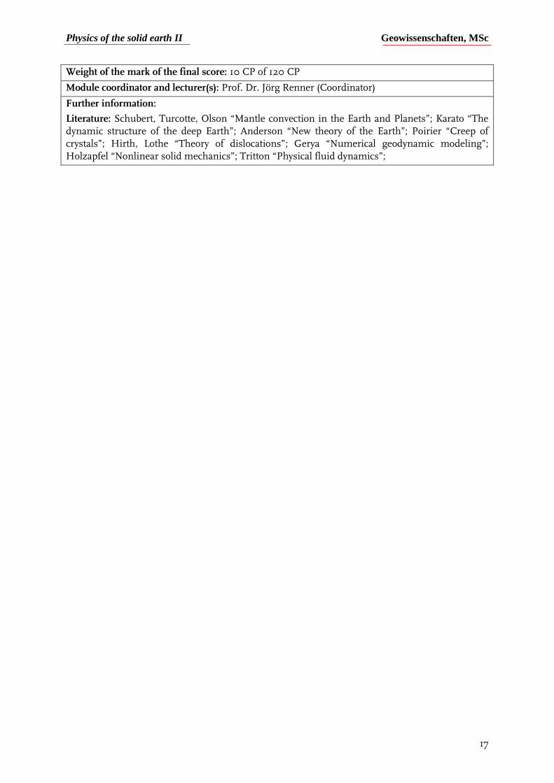
Physics of the solid earth II Geowissenschaften, MSc
17
Weight of the mark of the final score: 10 CP of 120 CP
Module coordinator and lecturer(s): Prof. Dr. Jörg Renner (Coordinator)
Further information:
Literature: Schubert, Turcotte, Olson “Mantle convection in the Earth and Planets”; Karato “The dynamic structure of the deep Earth”; Anderson “New theory of the Earth”; Poirier “Creep of crystals”; Hirth, Lothe “Theory of dislocations”; Gerya “Numerical geodynamic modeling”; Holzapfel “Nonlinear solid mechanics”; Tritton “Physical fluid dynamics”;
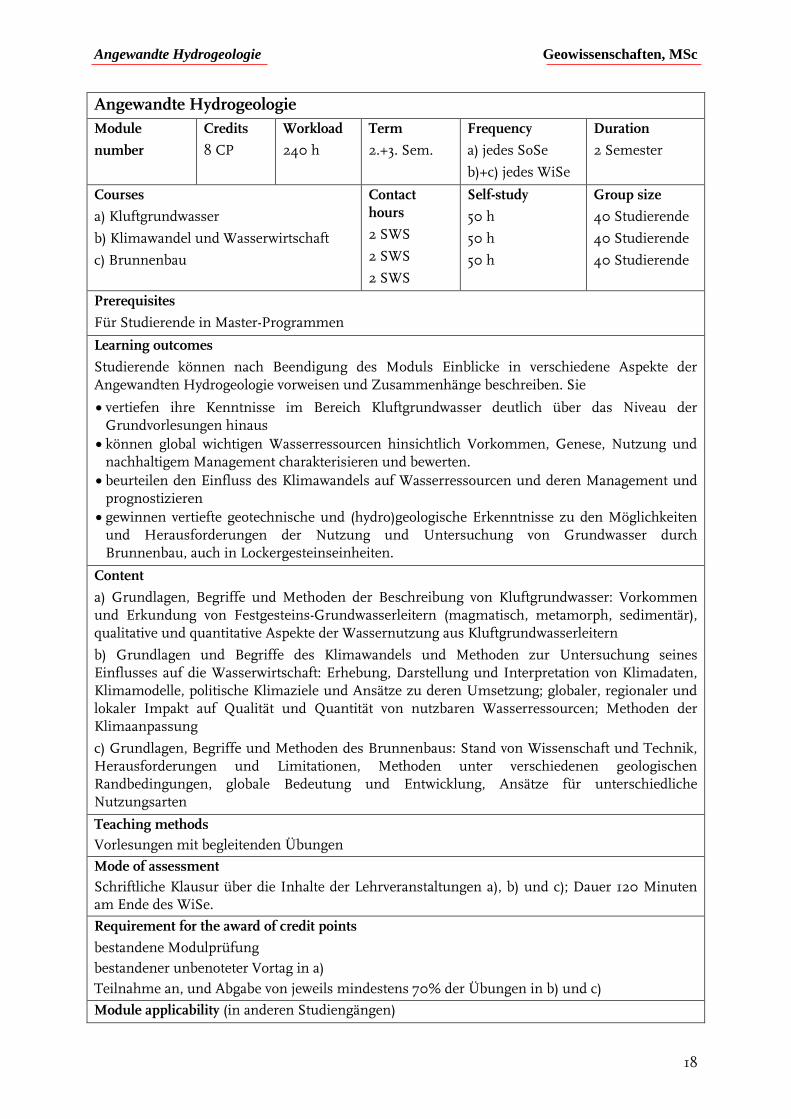
Angewandte Hydrogeologie Geowissenschaften, MSc
18
Angewandte Hydrogeologie
Module
number
Credits
8 CP
Workload
240 h
Term
2.+3. Sem.
Frequency
a) jedes SoSe
b)+c) jedes WiSe
Duration
2 Semester
Courses
a) Kluftgrundwasser
b) Klimawandel und Wasserwirtschaft
c) Brunnenbau
Contact hours
2 SWS
2 SWS
2 SWS
Self-study
50 h
50 h
50 h
Group size
40 Studierende
40 Studierende
40 Studierende
Prerequisites
Für Studierende in Master-Programmen
Learning outcomes
Studierende können nach Beendigung des Moduls Einblicke in verschiedene Aspekte der Angewandten Hydrogeologie vorweisen und Zusammenhänge beschreiben. Sie
vertiefen ihre Kenntnisse im Bereich Kluftgrundwasser deutlich über das Niveau der Grundvorlesungen hinaus
können global wichtigen Wasserressourcen hinsichtlich Vorkommen, Genese, Nutzung und nachhaltigem Management charakterisieren und bewerten.
beurteilen den Einfluss des Klimawandels auf Wasserressourcen und deren Management und prognostizieren
gewinnen vertiefte geotechnische und (hydro)geologische Erkenntnisse zu den Möglichkeiten und Herausforderungen der Nutzung und Untersuchung von Grundwasser durch Brunnenbau, auch in Lockergesteinseinheiten.
Content
a) Grundlagen, Begriffe und Methoden der Beschreibung von Kluftgrundwasser: Vorkommen und Erkundung von Festgesteins-Grundwasserleitern (magmatisch, metamorph, sedimentär), qualitative und quantitative Aspekte der Wassernutzung aus Kluftgrundwasserleitern
b) Grundlagen und Begriffe des Klimawandels und Methoden zur Untersuchung seines Einflusses auf die Wasserwirtschaft: Erhebung, Darstellung und Interpretation von Klimadaten, Klimamodelle, politische Klimaziele und Ansätze zu deren Umsetzung; globaler, regionaler und lokaler Impakt auf Qualität und Quantität von nutzbaren Wasserressourcen; Methoden der Klimaanpassung
c) Grundlagen, Begriffe und Methoden des Brunnenbaus: Stand von Wissenschaft und Technik, Herausforderungen und Limitationen, Methoden unter verschiedenen geologischen Randbedingungen, globale Bedeutung und Entwicklung, Ansätze für unterschiedliche Nutzungsarten
Teaching methods
Vorlesungen mit begleitenden Übungen
Mode of assessment
Schriftliche Klausur über die Inhalte der Lehrveranstaltungen a), b) und c); Dauer 120 Minuten am Ende des WiSe.
Requirement for the award of credit points
bestandene Modulprüfung
bestandener unbenoteter Vortag in a)
Teilnahme an, und Abgabe von jeweils mindestens 70% der Übungen in b) und c)
Module applicability (in anderen Studiengängen)

Angewandte Hydrogeologie Geowissenschaften, MSc
19
Weight of the mark for the final score
6,66 % der Gesamtnote (8 von 120 CP)
Module coordinator and lecturer(s)
Prof. Dr. Stefan Wohnlich
Further information
Relevante Fachliteratur wird am Beginn der jeweiligen Veranstaltungen vorgestellt.
Applied geothermal energy Geowissenschaften, MSc
20
Applied geothermal energy
Module number
Credits
9 CP
Workload
270 h
Term
1.+ 2. Sem.
Frequency
a) each WiSe
b)+c) each SoSe
Duration
2 Semesters
Courses
a) Shallow geothermal energy
b) Deep geothermal energy
c) Induced seismicity seminar
Contact time
2 SWS
3 SWS
2 SWS
Self-study
50 h
65 h
50 h
Group size
40 students
Prerequisites
For students in Master programs
Learning objectives
After completion of the module, the participants will
be able to dimension simple planning examples for geothermal plants and to determine the necessary parameters.
understand various sub-areas of geothermal energy (shallow and deep geothermal energy) as well as the different types of geothermal systems (hydrothermal, petrothermal, open and closed systems).
understand the theoretical background and current calculation methods,
know the legal principles and guidelines for the construction of geothermal plants and boreholes. The deep geothermal energy course deals with physical heat transfer processes at greater depths and the associated processes that are important for the optimal energy yield of such systems.
In many cases, induced seismicity occurs when the subsurface is used. In addition to the possible uses, the students will also be sensitized to this problem and its relevance for the technical system as well as the population affected.
Content
a) General insight into shallow geothermal energy: Overview of geothermal energy and energy in Germany, functioning of heat pumps, guidelines and legal bases, open and closed systems, dimensioning of geothermal probe systems, insight into seasonal heat reservoirs
b) Fundamentals and methods of deep geothermal energy: Potentials and uses in Germany and internationally, geophysical exploration and characterisation of deep geothermal reservoirs
c) Overview and basics of anthropogenically induced seismicity , (inter)national case studies, impacts on infrastructure and population, prevention and countermeasures
Teaching methods
Lectures with accompanying exercises
Seminar with student presentations
Mode of assessment
Written examination on the contents of courses a) and b); duration: 120 minutes at the end of the summer semester.
Evaluated seminar presentations (15 minutes) in c)
Requirements for the award of credit points
Passed module examination
Participation in, and submission of at least 70 % of the exercises in a) and b)
Participation in seminar c) (at least 70 % of dates)
Module applicability (in other programs)

Applied geothermal energy Geowissenschaften, MSc
21
Weight of the mark for the final score
7,5 % of the total grade (9 of 120 CP)
Module coordinator and lecturer(s)
Prof. Dr. Stefan Wohnlich
Other information
Relevant technical literature will be presented at the beginning of each course.
GIS in hydrogeology Geowissenschaften, MSc
22
GIS in hydrogeology
Modul
number
Credits
5 CP
Workload
150 h
Term
3. Sem.
Frequency
each WiSe
Duration
1 Semester
Courses
a) Theory and programme handling b) Project-based learning
Contact hours
2 SWS
1 SWS
Self-study
105 h
Group size
40 students
Prerequisites
For students in Master programmes
Learning outcomes
After completion of the module, the participants will
know the theoretical background of Geographical Information Systems and the types of data processed in GIS
handle the most widespread GIS software in terms of data preparation and import to the system, and the most important tools for data processing and visualization
understand the benefits of GIS for solving real spatial hydrogeological problems by independently using GIS in two projects dealing with water resources and hydrogeology in Saudi-Arabia, and the water balance for a catchment area in Germany
have acquired software-based instrumental and communicative competences
have gained experience and competences in the result-oriented description of GIS applications and result presentation in the form of an expert´s report
Content
a) Basics, terms and methods of geographical information systems: Geodata management, geo referencing, isoline maps, catchment area determination, water balance calculations, visualization and map generation b) Application of theoretical background in guided exercises based on two project examples, presentation of results and maps in the form of expert´s reports
Teaching methods
Lectures with accompanying exercises
Software exercises using the programme ArcGIS
Mode of assessment
Module exam. Evaluated written reports for each a) and b)
Requirement for the award of credit points
Passed module examination
Participation in at least 70 % of the exercises in a) and b)
Module applicability
Weight of the mark for the final score
4,17 % of the total grade (5 of 120 CP)
Module coordinator and lecturer(s)
PD Dr. Andre Banning
Further information
Relevant technical literature will be presented at the beginning of each course.
Groundwater hydraulics Geowissenschaften, MSc
23
Groundwater hydraulics
Module number
Credits
10 CP
Workload
300 h
Term
1.+2. Sem.
Frequency
a) each WiSe
b) each SoSe
Duration
2 Semesters
Courses
a) Groundwater hydraulics
b) Hydraulic groundwater modelling
Contact hours
4 SWS
4 SWS
Self-study
105 h
75 h
Group size
50 students
40 students
Prerequisites
For students in Master programmes
Learning outcomes
At the end of the module, participants will
be able to describe and evaluate groundwater flow and conservative mass transport in the subsurface.
know methods of experimental investigation and determination of hydraulic parameters under different boundary conditions, and can derive and evaluate these mathematically.
be familiar with the evaluation and interpretation of groundwater hydraulic parameters and use them to deal with classical hydrogeological problems.
be able to use numerical modelling approaches to effectively model groundwater flow based on existing hydrogeological information.
be in the position to estimate and describe the quality and limitations of hydraulic models and use them to predict future situations.
Content
a)- Methods for the collection and evaluation of hydraulic parameters (Darcy-tests, pump tests, Slug&Bail tests)
- Conveyance of knowledge about groundwater flow and the construction of groundwater level plans
- Execution and evaluation of pumping tests by means of graphical and analytical solutions
- Practical tasks for lowering the groundwater level through well systems in excavation pits or calculation of well yield
b)- Teaching of knowledge and methods for understanding and evaluation of mass transport processes in groundwater
- Methods for quantifying the subsurface (geostatistical approaches)
- Knowledge transfer for the modelling of mass transport with regard to the structure of a model, boundary conditions, advantages and disadvantages of models and how modelling programs work
- Visualization and interpretation of model results
Teaching methods
Lectures with accompanying calculation exercises
Software exercises (FeFlow) on the PC
Mode of assessment
Written examination on the contents of the courses ‚Groundwater hydraulics‘ and ‚Hydraulic groundwater modelling‘; duration: 120 minutes at the end of the winter semester.
Requirements for the award of credit points
Passed module examination
Participation in, and submission of at least 70% of the exercises in each a) and b)
Groundwater hydraulics Geowissenschaften, MSc
24
Module applicability (in other programs)
Weight of the mark for the final score
8,33 % of the total grade (10 of 120 CP)
Module coordinator and lecturer(s)
Prof. Dr. Stefan Wohnlich
Other information
Relevant technical literature will be presented at the beginning of each course.
Hydrogeochemische Methoden Geowissenschaften, MSc
25
Hydrogeochemische Methoden
Module number
Credits
10 CP
Workload
300 h
Term
2.+3. Sem.
Frequency
a) jedes WiSe
b)+c) jedes SoSe
Duration
2 Semester
Courses
a) Isotopenhydrologie
b) Umweltforensik
c) Hydrogeochemische Modellierung
Contact hours
4 SWS
2 SWS
3 SWS
Self-study
75 h
30 h
60 h
Group size
40 Studierende
Prerequisites
Für Studierende in Master-Programmen
Learning outcomes
Studierende sind nach Abschluss des Moduls in der Lage, die Bedeutung von Isotopenverhältnissen für die Erforschung der Herkunft von Wasser und gelösten Inhaltsstoffen im hydrologischen Kreislauf zu erfassen. Sie kennen ein breites Spektrum an relevanten Isotopensystemen, die in den Bereichen Hydrogeologie und Umweltgeowissenschaften weite Anwendung bei verschiedensten Fragestellungen finden. Sie kennen analytische Methoden zur Erhebung von Isotopendaten, und können diese verarbeiten und bewerten. Die Vorlesung wird durch kursbegleitende Übungen anhand realer Fallbeispiele ergänzt.
Die anthropogene Nutzung von Grundwasser ist häufig mit der Kontamination desselben verbunden. Es wird rechtlich, ökonomisch und ökologisch zunehmend relevanter, die Verursacher derartiger Kontaminationen zu identifizieren. Dazu bietet das aufstrebende Feld der Umweltforensik einige methodische Möglichkeiten, die die Teilnehmenden kennen und anwenden lernen.
Die Hydrogeochemische Modellierung ermöglicht den Studierenden ein vertieftes Verständnis der behandelten hydrogeochemischen Prozesse und ihre Abbildung in Modellform. Sie begreifen den Mehrwert numerischer Gleichgewichtsmodellierung für hydrochemische Daten, und können die Auswirkungen unterschiedlicher Rahmenbedingungen auf die Verteilung gelöster Stoffe beschreiben, bewerten und prognostizieren.
Content
a) Grundlagen, Begriffe und Methoden der Isotopenhydrologie: Stabile und radioaktive Isotope, relevante Isotopensysteme und –verhältnisse, Fraktionierungsprozesse, analytische Methoden, Interpretationsmöglichkeiten bei hydrologischen und hydrogeologischen Fragestellungen
b) Grundlagen, Begriffe und Methoden der Umweltforensik: Verursacherprinzip und rechtliche Grundlagen, hydrochemische Proxies und Indikatoren, Möglichkeiten der Nutzung von Tracern und Isotopenverhältnissen, internationale und nationale Fallbeispiele
c) Grundlagen, Begriffe und Methoden der Hydrogeochemischen Modellierung: Modelle und Datenbanken, Simulation hydrochemischer Gleichgewichtsreaktionen, Mischungsreaktionen, kinetisch kontrollierte Reaktionen, inverse Modellierung, 1D reaktiver Stofftransport
Teaching methods
Vorlesungen mit begleitenden Übungen
Softwareübungen (PhreeqC) am PC
Mode of assessment
Schriftliche Klausur über die Inhalte der Lehrveranstaltungen a) und b) und c); Dauer 120 Minuten am Ende des SoSe.
Requirement for the award of credit points
bestandene Klausur zu a), b) und c)
Hydrogeochemische Methoden Geowissenschaften, MSc
26
Teilnahme an, und Abgabe von jeweils mindestens 70% der Übungen in a), b) und c)
Module applicability (in anderen Studiengängen)
Weight of the mark for the final score
8,33 % der Gesamtnote (10 von 120 CP)
Module coordinator and lecturer(s)
Prof. Dr. Tobias Licha
Further information
Relevante Fachliteratur wird am Beginn der jeweiligen Veranstaltungen vorgestellt.
Drilling engineering 1 – Geotechnical. and near-surface drilling Geowissenschaften, MSc
27
Drilling engineering 1 – Geotechnical and near-surface drilling
Module number
Credits
5 CP
Workload
150 h
Term
3. Sem.
Frequency
a) jedes WiSe
Duration
1 Semester
Courses
Drilling 1
Exercises in drilling 1
Contact hours
5 SWS
Self-study
75 h
Group size
40 Studierende
Prerequisites
Für Studierende in Master-Programmen
Learning outcomes
The course presents an introduction to drilling technologies, focussing on shallow, near-surface applications like geothermal borehole heat exchangers, water and monitoring wells, geotechnical as well as environmental investigation. Dry, augering and mud drilling techniques will be compared and discussed, as well as sampling and coring for different applications
Introduction to geotechnical investigations and selected standards –
Rotary drilling with direct circulation including tooling –
Rotary drilling with indirect circulation including tooling, applications, air lifting –
Mud losses, artisean conditions while drilling, cementing –
Water and monitoring wells, well testing, sampling –
Shallow geothermal, borehole heat exchanger systems – Environmental Direct Push sampling, coring, onsite analysis
Contents
Basics of shallow drilling –
Coring and cuttings –
Geotechnical exploration, probing and analysis (DIN 4021 / EN ISO 22475) – Foundation work and drillling –
Water well drilling and completion –
Shallow geothermal drilling, completion and applications including standard W 120 –
Quality assurance and control of shallow geothermal BHE systems
Teaching methods
Classroom and hands on lectures, field work on the rig and its auxiliary equipment, laboratory experiments, practical case studies
Mode of assessment
Written examination (60 Min.).
Requirement for the award of credit points
According to current examination regulations
Module applicability (in anderen Studiengängen)
Weight of the mark for the final score
4,17 % der Gesamtnote (5 von 120 CP)
Module coordinator and lecturer(s)
Prof. Dr. Stefan Wohnlich (Lehrtransfer von Geothermie Zentrum Bochum)
Further information
Relevante Fachliteratur wird am Beginn der jeweiligen Veranstaltungen vorgestellt.
Field Courses in applied geology Geowissenschaften, MSc
28
Field Courses in applied geology
Module
number
Credits
7 CP
Workload
210 h
Term
MSc
Frequency
annual
Duration
14 days
Courses
Field Courses in applied geology in various hydrogeological settings (Europe, South America, …)
Contact hours
14 Tage
Self-study
98 h
Group size
Depending on the location of the courses. between 12 and 20 Students
Prerequisites
For students in the Masters Programm Geosciences with the focus in Applied Geology, Sedimentology, Mineralogy, and Crystallography
Learning outcomes
The learning aims are dependent on the topics of the field course. The field courses combine aspects of applied Geology (Hydrogeology, Engineering Geology, Geothermal Energy, Economic Geology) with general geological knowledge like Structural Geology, Sedimentology, Geophysics etc. Generally, the aim is to give the students the possibility to combine knowledge from classes and laboratory exercises with field observation in order to construct a sound Geological Model, that can be applied to practical purposes like Mining, Engineering of Geothermal Applications.
After the successful attendance of the module the students are able to understand the complexity of geological settings.
Content
Depends on the field area.
Teaching methods
Seminar before the field trip, discussions in the field, planning and independent work in the field.
Mode of assessment
The module is graded on the basis of the evaluation of the lecture and the report from the pre-seminar and the submitted sketches and reports. Participation in the fieldwork. The pro-seminar consists of a lecture on selected topics (10-15 minutes) and submission of an abstract of the talk (1-2 pages). Presentation of 4-5 sketches of the field settings (done in the field and refined in the evenings in the field camp). The original copy as well the refined copy are to be submitted.
Requirement for the award of credit points
Active participation in the field work, discussion and seminars. Inability to participate in more than 33% of the field days may be excused only on very well-founded medical grounds; otherwise such absence will lead to a failing grade in the module.
Module applicability
The module is open to students specializing in Sedimentology, Crystallography or Petrology as well. In exceptional cases, after discussion with the instructor, students specializing in other subfields of geosciences may also participate.
Weight of the mark for the final score
9,6 % of the overall grade (8 of 120 CP).
Module coordinator and lecturer(s)
Prof. Dr. S. Wohnlich (Modulbeauftragter), Assistants in Hydrogeologie in cooperation with other lecturers of GMG.
Further information
Please contact the instructor if you have questions.
Field Courses in applied geology Geowissenschaften, MSc
29
Literature
Relevant technical literature will be presented at the beginning of each course
Hydrochemistry Geowissenschaften, MSc
30
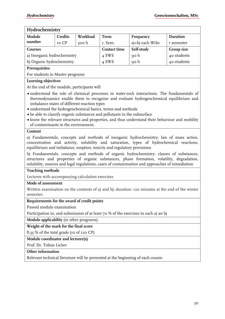
Hydrochemistry
Module number
Credits
10 CP
Workload
300 h
Term
1. Sem.
Frequency
a)+b) each WiSe
Duration
1 semester
Courses
a) Inorganic hydrochemistry
b) Organic hydrochemistry
Contact time
4 SWS
4 SWS
Self-study
90 h
90 h
Group size
40 students
40 students
Prerequisites
For students in Master programs
Learning objectives
At the end of the module, participants will
understand the role of chemical processes in water-rock interactions. The fundamentals of thermodynamics enable them to recognize and evaluate hydrogeochemical equilibrium and imbalance states of different reaction types
understand the hydrogeochemical basics, terms and methods
be able to classify organic substances and pollutants in the subsurface
know the relevant structures and properties, and thus understand their behaviour and mobility of contaminants in the environment.
Content
a) Fundamentals, concepts and methods of inorganic hydrochemistry: law of mass action, concentration and activity, solubility and saturation, types of hydrochemical reactions, equilibrium and imbalance, sorption, toxicity and regulatory provisions
b) Fundamentals, concepts and methods of organic hydrochemistry: classes of substances, structures and properties of organic substances, phase formation, volatility, degradation, solubility, sources and legal regulations, cases of contamination and approaches of remediation
Teaching methods
Lectures with accompanying calculation exercises
Mode of assessment
Written examination on the contents of a) and b); duration: 120 minutes at the end of the winter semester.
Requirements for the award of credit points
Passed module examination
Participation in, and submission of at least 70 % of the exercises in each a) an b)
Module applicability (in other programs)
Weight of the mark for the final score
8,33 % of the total grade (10 of 120 CP)
Module coordinator and lecturer(s)
Prof. Dr. Tobias Licher
Other information
Relevant technical literature will be presented at the beginning of each course.
Hydrogeologische Geländemethoden Geowissenschaften, MSc
31
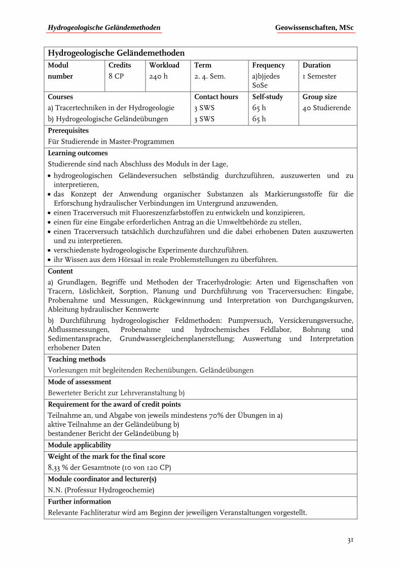
Hydrogeologische Geländemethoden
Modul
number
Credits
8 CP
Workload
240 h
Term
2. 4. Sem.
Frequency
a)b)jedes SoSe
Duration
1 Semester
Courses
a) Tracertechniken in der Hydrogeologie
b) Hydrogeologische Geländeübungen
Contact hours
3 SWS
3 SWS
Self-study
65 h
65 h
Group size
40 Studierende
Prerequisites
Für Studierende in Master-Programmen
Learning outcomes
Studierende sind nach Abschluss des Moduls in der Lage,
hydrogeologischen Geländeversuchen selbständig durchzuführen, auszuwerten und zu interpretieren,
das Konzept der Anwendung organischer Substanzen als Markierungsstoffe für die Erforschung hydraulischer Verbindungen im Untergrund anzuwenden,
einen Tracerversuch mit Fluoreszenzfarbstoffen zu entwickeln und konzipieren,
einen für eine Eingabe erforderlichen Antrag an die Umweltbehörde zu stellen,
einen Tracerversuch tatsächlich durchzuführen und die dabei erhobenen Daten auszuwerten und zu interpretieren.
verschiedenste hydrogeologische Experimente durchzuführen.
ihr Wissen aus dem Hörsaal in reale Problemstellungen zu überführen.
Content
a) Grundlagen, Begriffe und Methoden der Tracerhydrologie: Arten und Eigenschaften von Tracern, Löslichkeit, Sorption, Planung und Durchführung von Tracerversuchen: Eingabe, Probenahme und Messungen, Rückgewinnung und Interpretation von Durchgangskurven, Ableitung hydraulischer Kennwerte
b) Durchführung hydrogeologischer Feldmethoden: Pumpversuch, Versickerungsversuche, Abflussmessungen, Probenahme und hydrochemisches Feldlabor, Bohrung und Sedimentansprache, Grundwassergleichenplanerstellung; Auswertung und Interpretation erhobener Daten
Teaching methods
Vorlesungen mit begleitenden Rechenübungen. Geländeübungen
Mode of assessment
Bewerteter Bericht zur Lehrveranstaltung b)
Requirement for the award of credit points
Teilnahme an, und Abgabe von jeweils mindestens 70% der Übungen in a) aktive Teilnahme an der Geländeübung b) bestandener Bericht der Geländeübung b)
Module applicability
Weight of the mark for the final score
8,33 % der Gesamtnote (10 von 120 CP)
Module coordinator and lecturer(s)
N.N. (Professur Hydrogeochemie)
Further information
Relevante Fachliteratur wird am Beginn der jeweiligen Veranstaltungen vorgestellt.
Siedlungswasserwirtschaft Geowissenschaften, MSc
32
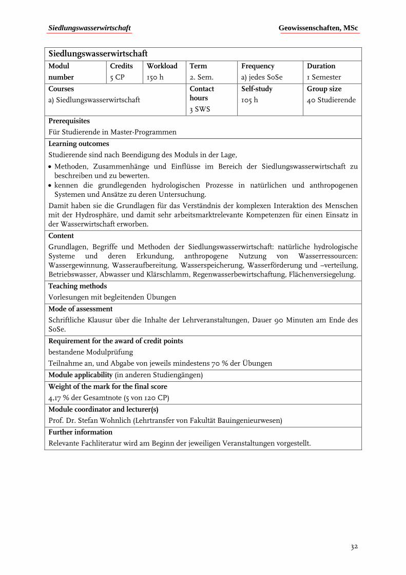
Siedlungswasserwirtschaft
Modul
number
Credits
5 CP
Workload
150 h
Term
2. Sem.
Frequency
a) jedes SoSe
Duration
1 Semester
Courses
a) Siedlungswasserwirtschaft
Contact hours
3 SWS
Self-study
105 h
Group size
40 Studierende
Prerequisites
Für Studierende in Master-Programmen
Learning outcomes
Studierende sind nach Beendigung des Moduls in der Lage,
Methoden, Zusammenhänge und Einflüsse im Bereich der Siedlungswasserwirtschaft zu beschreiben und zu bewerten.
kennen die grundlegenden hydrologischen Prozesse in natürlichen und anthropogenen Systemen und Ansätze zu deren Untersuchung.
Damit haben sie die Grundlagen für das Verständnis der komplexen Interaktion des Menschen mit der Hydrosphäre, und damit sehr arbeitsmarktrelevante Kompetenzen für einen Einsatz in der Wasserwirtschaft erworben.
Content
Grundlagen, Begriffe und Methoden der Siedlungswasserwirtschaft: natürliche hydrologische Systeme und deren Erkundung, anthropogene Nutzung von Wasserressourcen: Wassergewinnung, Wasseraufbereitung, Wasserspeicherung, Wasserförderung und –verteilung, Betriebswasser, Abwasser und Klärschlamm, Regenwasserbewirtschaftung, Flächenversiegelung.
Teaching methods
Vorlesungen mit begleitenden Übungen
Mode of assessment
Schriftliche Klausur über die Inhalte der Lehrveranstaltungen, Dauer 90 Minuten am Ende des SoSe.
Requirement for the award of credit points
bestandene Modulprüfung
Teilnahme an, und Abgabe von jeweils mindestens 70 % der Übungen
Module applicability (in anderen Studiengängen)
Weight of the mark for the final score
4,17 % der Gesamtnote (5 von 120 CP)
Module coordinator and lecturer(s)
Prof. Dr. Stefan Wohnlich (Lehrtransfer von Fakultät Bauingenieurwesen)
Further information
Relevante Fachliteratur wird am Beginn der jeweiligen Veranstaltungen vorgestellt.
Earthquake processes Geowissenschaften, MSc
33
Earthquake processes
Module number
Credits
6 CP
Workload
180 h
Term
1. MSc Sem.
Frequency
WiSe
Duration
1 Semester
Courses
a) Earthquake seismology and the seismic cycle
Contact hours
4 SWS
Self-study
120 h
Group size
30 Students
Prerequisites
This module will give an introduction to the world of earthquakes and the methods used to study them. Fundamental mechanics of faulting and earthquakes will be explored from theoretical, observational and experimental perspectives. The course is open to all MSc students with a background in the Earth sciences (BSc degree).
Students must have successfully completed a BSc in the earth sciences. The course consists of scientific paper discussion as well as lecture, and paper discussion must be evaluated a passing grade (60%) to complete the final report on which the module grade will be based. Final reports may be completed in German if desired.
Learning outcomes
After successful completion of the module, students will be able to
understand and explain earthquake source parameters such as seismic moment, magnitude, static stress drop, radiated energy, and spectral corner frequency
understand how earthquake source parameters are measured and quantified, such as via fault plane solutions, moment tensors, directivity
understand and explain empirical earthquake relations, such as the Gutenberg-Richter magnitude-frequency relation, Omori’s Law
understand the basics of seismic signal processing and its applications to studies of earthquakes
understand and explain the relation between earthquake occurrence and friction on fault surfaces, as well as fracture mechanics models of earthquakes
understand and explain the earthquake cycle and the occurrence of intraplate and interpolate earthquakes
relate earthquake triggering and induced earthquakes to tectonic and stress loading, and identify possible earthquake triggers
understand and describe physical characteristics and underlying mechanisms of the various types of volcanic seismic signals observed at active volcanoes
Content
Topics included in the course include: Earthquake source studies (focal mechanisms, moment tensors, directivity, seismic moment, source spectra and scaling laws, energy partitioning, stress drop and radiated energy), earthquake statistics, fundamentals of seismic signal processing, fracture mechanics and its relation to rate-state friction, fault friction and the effects of temperature and pressure at depth, earthquake cycle deformation and the spectrum of fault slip, inter- and intraplate earthquakes, fault drilling, volcanic earthquakes, and triggered and induced earthquakes.
All lecture materials are digitally available via the course Moodle, and student projects are strongly encouraged to incorporate digital data processing. Lectures and paper discussion occur in English.
Teaching methods
Lecture period of 2 hours/week followed by paper discussion of 2 hours/week.
Mode of assessment
Earthquake processes Geowissenschaften, MSc
34
Final report weighted 70% for the written component (with a 10-week working period), with the remaining 30% weight being placed on the oral presentation the last week of the lecture period. Paper discussion will be evaluated based on participation, and must be completed with a passing grade of 60% in order to submit the final report.
Requirements for the award of credit points
Passing grade for the paper discussion entitles the course participant to submit the Module Exam (Report). Module Report with a passing grade (written and oral parts will be combined for a total number of points).
Module applicability (in other majors)
Weight of the mark for the final score
5% of the total Grade (6/120 CPs)
Module coordinator and lecturer(s)
Prof. Dr. Rebecca Harrington
Further information
Helpful texts (not required):
Stein, S. and M. Wyssession, Introduction to Seismology, Earthquakes, and Earth Structure, Blackwell Publishing, 2003
Scholz, C. H., The Mechanics of Earthquakes and Faulting, 2nd Ed., Cambridge University Press, 2002

Earthquakes seminar and data analysis Geowissenschaften, MSc
35
Earthquakes seminar and data analysis
Module number
Credits
9 CP
Workload
270 h
Term
MSc
Frequency
every Semester
Duration
2 Semesters
Courses
a) Induced seismicity seminar
b) Fault transition zones
c) Seismic data and time series Analysis
Contact hours
2 SWS
2 SWS
2 SWS
Self-study
60 h
60 h
60 h
Group size
30 Students
30 Students
18 Students
Prerequisites
The course module is open to all MSc students with a background in the Earth sciences (BSc degree).
The course consists of scientific paper discussion (a) and (b), as well as lecture and exercises for (c). The paper discussion in (a) and (b) as well as exercises in (c) must be evaluated a passing grade (70%) to complete the final report (due upon completion of (c)) on which the module grade will be based.
Learning outcomes
After successful completion of the module, students will
understand the different causes of induced earthquakes, including fluid injection from unconventional energy production, mining, gas/fluid extraction
be familiar with the geological settings and controls in which earthquakes are produced
understand and describe the statistical properties of induced earthquakes, as well as the current understanding of correlations between injection parameters and event magnitude
be familiar with the competing influence of effective vs. poroelastic stress transfer in the role of generating fault failure, as well the current related scientific studies
understand the chemical and mechanical differences in the brittle-ductile transition zone, and the relation to seismic vs. aseismic slip generation
have a quantitative understanding of the different types of slip events that generate a spectrum of seismic and aseismic signals, including tectonic tremor and LFEs, and slow-slip events
have the programming skills to perform basic signal processing and data analysis on the different types of seismic signals listed above, and to visualize results digitally
Content
Overview of induced earthquakes in the context of fluid flow near faults and fault systems, the influence of lithology and geology on generating induced earthquakes, statistics and source properties of induce earthquakes, earthquakes induced by reservoir impoundment, gas extraction, enhanced geothermal systems, wastewater and hydraulic fracturing injection, physical mechanisms that induce fault slip, the seismogenic and brittle-ductile transition zone in the crust, seismic and geodetic signals from the seismogenic and fault tranisition zone, slow earthquakes and triggering of earthquakes at shallower depths, slow earthquakes as stress meters, the rock record of fault slip, experimental work on slow earthquakes, tectonic tremor, transition zone evolution after large earthquakes. Digital analysis of seismic signals including, installation and setup of seismic analysis software (Python), making maps, downloading and analyzing earthquake catalog data, picking seismic phases, analyzing earthquake source parameters, and visualizing all results.
Teaching methods
Courses (a) and (b) are held in a group discussion format, where (c) consists of digital teaching format with accompanying lectures.

Earthquakes seminar and data analysis Geowissenschaften, MSc
36
Mode of assessment
The grade for the module is based on the grade for the report due after the completion of course (c) (it is recommended but not required to complete both (a) and (b) before the completion of (c)). Courses (a) and (b) require leading at least one group discussion on a weekly reading topic, as well as active participation in discussions, and will be evaluated on a pass/no-pass (70%) basis. Courses (a) and (b) must be completed with a “pass” basis in order for the final module grade to be given upon completion of the report in (c).
Requirements for the award of credit points
Passing grades for courses (a) and (b) require the presentation/leading of one reading topic and active participation in 70% of the discussions. The report grade for (c) will be distributed once (a) and (b) have been successfully completed.
Module applicability
Weight of the mark for the final score
7,5% of the total grade (9/120 CPs)
Module coordinator and lecturer(s)
Prof. Dr. Rebecca Harrington
Further information

Reservoir and fault geomechanics Geowissenschaften, MSc
37
Reservoir and fault geomechanics
Module number
Credits
9 CP
Workload
270 h
Term
1. + 2. Sem.
Frequency
Every year
Duration
2 Semesters
Courses
a) Stress field and rock mass behavior
b) Hydrogeomechanics
Contact hours
2 SWS
4 SWS
Self-study
60 h
120 h
Group size
30 Students
30 Students
Prerequisites
The module is open to all MSc students with a background in the Earth sciences (BSc degree). Prior knowledge of Matlab is helpful, but not required. Final reports in (b) may be written in German, if desired.
Learning outcomes
After successful completion of the module, students will be able to:
explain the sources of stress in the earth’s crust
understand and quantify forces, traction, and stress in a continuum
understand and describe the relationship between stress, strain and constitutive relations, and compute stress and strain using tensor algebra
understand and apply the basics of poroelastic stress formulation in a 2D poroelastic model
understand the fundamentals of rock failure, failure in boreholes, and fault formation
understand and describe the measurement of maximum and minimum horizontal stress
understand and calculate the conditions in which borehole failure occurs
understand geophysical measurements made in boreholes, and the measurements of orientation and magnitude of stresses in a borehole, and fundamentals of interpreting borehole logs
describe and understand the formation of fault systems, and how earthquakes can be used to measure regional stress orientations
Content
a) Stress field and stress modeling: Define stress in a continuum, quantify stresses in the Earth’s crust, measurement and estimation of stresses in rocks, calculation of stresses around cavities, design a model of the stress field in the crust and complete integrated exercises to support concepts.
b) Hydrogeomechanics: This interdisciplinary course encompasses the fields of rock mechanics, structural geology, seismology and petroleum engineering to provide a background to tackle a range of geomechanical problems associated with fluid injection and/or extraction in wells and rock failure. Topics included in the course are: Forces, traction and stress, stress, strain, and constitutive relations, an introduction to poroelastic theory, applications of poroelastic models, rock failure in the lab and in the field, faults and fluid flow, probing the subsurface through logging, stresses around wells, and determining Shmin and SHmax.
In addition to theoretical information presented via lecture material, the practical exercises teach fundamental data analysis via MATLAB, and poroelastic modeling (POEL open source code), and all course materials are transferred via an online interface (Moodle).
Teaching methods
Lecture period of 2 hours/week with practical exercises of 2 hours/week. Exercises are mainly completed in digital format (basic programming in Matlab).
Mode of assessment
Module grade will be based on the final report in (b) weighted 70% for the written component
Reservoir and fault geomechanics Geowissenschaften, MSc
38
(with a 6-week working period), with the remaining 30% weight being placed on the oral presentation the last week of the lecture period. Exercises in (a) and (b) must be completed with a passing grade of 60% in order to submit the final report.
Requirement for the award of credit points
Passing grade for the exercises in (a) and (b) entitles the course participant to submit the Module Exam (Report). Module Report with a passing grade (written and oral parts will be combined for a total number of points).
Module applicability
Weight of the mark for the final score
7,5% of the total Grade (9/120 CPs)
Module coordinator and lecturer(s)
Prof. Dr. Rebecca Harrington, Prof. Dr. Tobias Backers
Further information
Helpful texts (not required):
Zang, A. Stephansson, O., Stress Field of the Earth’s Crust, Springer, 2010.
Zoback, M. D., Reservoir Geomechanics, Cambridge, 2010
Middleton, G. V., and Wilcock, P. R. Mechanics in the Earth and Environmental Sciences, Cambridge, 1994
Allmendinger, R. W., Cardozo,N., Fisher, D. M. Structural Geology Algorithms, Vectors and Tensors, Cambridge, 1998
Mapping active faults Geowissenschaften, MSc
39
Mapping active faults
Module number
Credits
6 CP
Workload
180 h
Term
1. Sem.
Frequency
SoSe
Duration
1 Semester
Courses
a) Mapping active faults
Contact hours
4 SWS
Self-study
120 h
Group size
15 Students
Prerequisites
The module is open to students with a BSc in the Earth sciences. Additional requirements include successful completion of an introductory geological mapping course. Students must also have successfully completed the module “Seismotectonics and Seismic Hazard” offered during the Winter Semester. The module grade will be based on the final field report.
Learning outcomes
During a 5 days’ field exercise the students will learn to:
recognize and map the geomorphic elements which characterize active normal faults (fault scarps); • Measure a coseismic fault scarp in order to define the “slip per event”;
measure a “multiple events” fault scarp in order to define the long term slip rate;
analyze and interpret a fault trench (gridding, logging);
use photogrammetry to reconstruct the 3D geometry of an outcrop;
process the collected data with dedicated software (GIS, stereonet, Agisoft PhotoScan)
This course module will use digital mapping tools (GeomapApp), and will have international scientists accompanying students in the field to provide local geological context.
Content
Recognizing and mapping the surface evidences of active faulting represent the first step towards a better understanding of the seismic hazard assessment of any region. Therefore, a practical experience in the field is of critical importance for all the geoscientists dealing with the “earthquake problem”. Central Italy is one of the most seismically active regions in Europe. Here thousands of years of earthquakes have created astonishing fault scarps and very peculiar geomorphic features which make this area a perfect laboratory for structural mapping. Topics included in the course are: Mapping and interpretation of geological structures characterized by active tectonics, geological data processing and analysis.
Teaching methods
5-days field exercise during the Pfingstwoche preceded by a 2-hours introductory class.
Mode of assessment
Course evaluation: The course will be evaluated on the basis of a field map handed in by the student at the conclusion of the field exercise, and a written field report due 4 weeks after the end of the field exercise. Field report (4 week working period).
Requirement for the award of credit points
Module report with a passing grade.
Module applicability
Weight of the mark for the final score
5% of the total Grade (6/120 CPs)
Module coordinator and lecturer(s)
Prof. Dr. Rebecca Harrington, Dr. Alessandro Verdecchia
Mapping active faults Geowissenschaften, MSc
40
Further information
Helpful texts (not required):
The Mapping of Geological Structures, Ken McClay, Geological society of London Handbook.
The Geology of Earthquakes, R. S. Yeats, K. Sieh and C. R. Allen, Oxford University Press, 1997.
Tectonic Geomorphology, D. W. Burbank and R. S. Anderson, Wiley-Blackwell, 2nd Ed.
Seismotectonics and seismic hazard Geowissenschaften, MSc
41
Seismotectonics and seismic hazard
Module number
Credits
6 CP
Workload
180 h
Term
2. Sem.
Frequency
WiSe
Duration
1 Semester
Courses
a) Seismotectonics and seismic hazard
Contact hours
4 SWS
Self-study
120 h
Group size
15 Students
Prerequisites
Students must have successfully completed a BSc in the earth sciences. The course consists of exercises as well as lecture, and exercises must be completed with a passing grade (60%) to access to the final exam on which the module grade will be based.
Learning outcomes
After successful completion of the module, students will be able to
understand the relationship between lithosphere rheology and earthquake distribution;
understand the relationship between frictional properties and faulting;
understand the basics of earthquake detection and location;
understand the relationship among subsequent earthquakes (earthquake and fault interactions);
understand the primary (faulting) and secondary (liquefaction, landslides, etc.) effects produced by seismic events;
understand the basics of Tectonic Geodesy;
understand the basics of Tectonic Geomorphology;
understand the basics of Paleoseismology;
understand the basics of probabilistic and deterministic seismic hazard calculations.
Content
A multidisciplinary approach is strongly needed in order to better understand the seismic potential of any region in the world. Geological data give us a long-term (thousands of years) view of earthquake phenomena, but they are limited to the first meters of the crust. Seismological and geophysical data can generally better describe deformation processes occurring at depth, but usually with a smaller temporal (tens of years) and spatial resolution. This course will provide an introduction to the earthquake problem from both geological and geophysical points of view, with emphasis on the methodologies commonly used to produce the data necessary to understand and quantify the seismic hazard in any active region.
Topics included in the course are: Rheology of the lithosphere, frictional properties of faults, the seismic cycle, earthquake location, geological effects of earthquakes, tectonic geodesy, tectonic geomorphology, paleoseismology, earthquake and fault interactions, probabilistic and deterministic seismic hazard.
In addition to theoretical information presented via lecture material, the practical exercises teach fundamental data analysis via MATLAB, and other software distributed during the course.
Teaching methods
Lecture period of 2 hours/week with practical exercises of 2 hours/week. Exercises are completed primarily in digital format (basic programming in Matlab).
Mode of assessment
Exercises must be completed with a passing grade of 60% in order to access the final exam.
The grade of the module is based on the grade of the final written exam.
Requirement for the award of credit points
Exercises must be completed with a passing grade of 60% in order to access the final exam.
The module grade is based on the final exam grade.
Seismotectonics and seismic hazard Geowissenschaften, MSc
42
Module applicability
Weight of the mark for the final score
5% of the total Grade (6/120 CPs)
Module coordinator and lecturer(s)
Prof. Dr. Rebecca Harrington, Dr. Alessandro Verdecchia
Further Information
Helpful texts (not required):
Structural Geology, Haakon Fossen, Cambridge University Press, 2013.
The Geology of Earthquakes, R. S. Yeats, K. Sieh and C. R. Allen, Oxford University Press, 1997.
The Mechanics of Earthquakes and Faulting, C. H. Scholz, Cambridge University Press, 2012.
Paleoseismology, J. P. McCalpin, Academic Press, 2nd Ed.
Felsmechanik und Felsbau Geowissenschaften, MSc
43
Felsmechanik und Felsbau
Module number
Credits
10 CP
Workload
300 h
Term
2. Sem.
Frequency
jährlich
Duration
1 Semester
Courses
a) Felsmechanik
b) Felsbau
c) Felskartierung
Contact hours
2 SWS
2 SWS
5 Tage
Self-study
60 h
60 h
80 h
Group size
20 Studierende
Prerequisites
Veranstaltung‚ Stress field and rock mass behavior muss mit > 75% bestanden sein.
Learning outcomes
Die Teilnehmerinnen und Teilnehmer sind
mit den Grundlagen der Rheologie der Gesteine, dem mechanischen Verhalten von Trennflächen, Gebirgsklassifikationen und mechanischen Eigenschaften des Gebirges vertraut und kennen die typischen Kennwerte nach Bedeutung und Größe.
haben sie die geomechanischen Grundlagen und Zusammenhänge vertieft.
sind mit den Grundlagen der Erstellung und Sicherung von Felsbauwerken vertraut.
erlernen die grundlegenden Methoden der ingenieurgeologischen Felskartierung. Hierzu gehören die Ansprache der Gesteine im Aufschluss, das Einmessen von Flächen, die Beschreibung der Trennflächen und deren Charakteristika. Die Methodik der Auswertung und Darstellung der im Gelände aufgenommenen Messwerte wird geübt. Die Anwendung einer Gebirgsklassifikation wird gefestigt.
erhalten Einblicke in felsbauliche Inhalte durch die Befahrung eines Bergwerkes.
Content
Deformation und Versagen von Gestein; Einführung in die Versuchstechnik; Deformation und Versagen von Trennflächen; Gebirgsklassifikationen; Deformation und Versagen von Fels; Charakteristika von Tunneln, Stollen und Felskavernen; Prinzipien des Hohlraumbaus; Gründungen auf Fels und Böschungen aus Fels; Aufgabenstellungen und Messgrößen bei der geotechnisch/geomechanischen Überwachung; Themen des Bergbaus, Tunnel- und Kavernenbaus, Talsperren; felsmechanische Aufnahme und Beschreibung des Trennflächengefüges.
Teaching methods
Vorlesungen mit integrierten Übungen
Bereitstellung von auf den Lehrinhalten aufbauenden Hausaufgaben
Geländeübung
Mode of assessment
Schriftliche Klausur über die Inhalte der Lehrveranstaltungen; Dauer 90 Minuten am Ende des Semesters.
Requirement for the award of credit points
mindestens 50% der Übungen in a) und b) erfolgreich bestanden
bestandene Geländeübung c), Bericht über die im Rahmen der Geländeübung gestellte Aufgabe; Bericht max. 20 Seiten; Berichtsabgabe 3 Wochen nach Ende der Geländeübung
bestandene Modulprüfung
Module applicability
Weight of the mark for the final score
8,33 % der Gesamtnote (10 von 120 CP)
Felsmechanik und Felsbau Geowissenschaften, MSc
44
Module coordinator and lecturer(s)
Prof. Dr. Tobias Backers
Further information
Relevante Fachliteratur wird am Beginn der jeweiligen Veranstaltungen vorgestellt.
Spezielle Ingenieurgeologie Geowissenschaften, MSc
45
Spezielle Ingenieurgeologie
Module number
Credits
10 CP
Workload
300 h
Term
3. Sem.
Frequency
jährlich
Duration
1 Semester
Courses
a) Spezielle Ingenieurgeologie
b) Ingenieurgeologisches Projekt
Contact hours
4 SWS
1 SWS
Self-study
115 h
110 h
Group size
20 Studierende
Prerequisites
Modulprüfung ‚Felsmechanik und Felsbau‘ mit > 40% absolviert.
Learning outcomes
Die Teilnehmenden
beherrschen die Normen und Methoden der Ingenieurgeologie in den verschiedenen baugeologischen Anwendungsgebieten. Hierbei liegt, soweit abgrenzbar, der Schwerpunkt auf den Tätigkeiten im Lockermaterialbereich. Der Schwerpunkt auf felsbauliche Aspekte liegt im Modul ‚Felsmechanik und Felsbau‘.
erarbeiten an einem Fallbeispiel ein ingenieurgeologisches Projekt selbstständig und wenden die im Rahmen des Curriculums der Ingenieurgeologie und Felsmechanik erlernten Grundlagen an. Hierdurch wird ein tiefergehendes Verständnis der geologischen und bautechnischen Zusammenhänge generiert und dies trainiert die Berücksichtigung ingenieurgeologischer Aspekte zur Problemlösung.
haben in Kleingruppen die Aufgabe bearbeitet, wodurch die Arbeit im Team profiliert wird
Content
Normung; Bodenarten, Bodenunterscheidung, Bodenklassifikation, Bodenkenngrößen; Flachgründungen und Geländebruch; Baugrundverbesserung; Pfahlgründungen; Baugruben und -sicherung; Bodenverbesserung und -verfestigung; Böschungen; Rutschungen; Dämme; Grundlagen Tunnel- und Talsperrenbau; spezielle Aspekte.
Teaching methods
Vorlesungen mit integrierten Übungen
Bereitstellung von auf den Lehrinhalten aufbauenden Hausaufgaben
Projektplanspiel
Mode of assessment
Mündliche Prüfung (30 min).
Requirement for the award of credit points
Bestandenes ingenieurgeologisches Projekt; hierbei aktive Teilnahme (20%) am Planspiel, Präsentation der Ergebnisse (30%) sowie Bericht (50%).
bestandene Modulprüfung
Module applicability
Weight of the mark for the final score
8,33 % der Gesamtnote (10 von 120 CP)
Module coordinator and lecturer(s)
Prof. Dr. Tobias Backers
Further information
Relevante Fachliteratur wird am Beginn der jeweiligen Veranstaltungen vorgestellt.
Kristallchemie Geowissenschaften, MSc
46
Kristallchemie
Module number
Credits
10 CP
Workload
300 h
Term
2. + 3. Sem.
Frequency
Duration
2 Semester
Courses
a) Kristallchemie (Vorlesung und Übung)
b) Realstrukturbau und Phasenumwandlungen (Vorlesung und Übung)
Contact hours
3 SWS
3 SWS
Self-study
105 h
105 h
Group size
12 Studierende
Prerequisites
Formal: Für Studierende in natur- und ingenieurwissenschaftlichen Masterprogrammen.
Textual: Kenntnisse über Aufbau und Symmetrieeigenschaften von Kristallen sowie Kenntnisse in der allgemeinen und anorganischen Chemie werden vorausgesetzt.
Preparation: –
Learning outcomes
Nach dem erfolgreichen Abschluss des Moduls
kennen Studierende die grundlegenden Prinzipien, die zur Ausbildung einer spezifischen Kristallstruktur führen,
kennen Studierende strukturelle Grundtypen sowie wichtige Strukturfamilien und deren Eigenschaften,
können die Studierenden strukturelle Instabilitäten erkennen und daraus resultierende Phasenumwandlungen klassifizieren,
sind die Studierenden in der Lage, die Auswirkungen von Phasenumwandlungen auf physikalische Eigenschaften von Kristallen und deren mögliche Anwendungen abzuschätzen.
Content
Atombau, Quantenzahlen.
Chemische Bindungen, Hybridisierung, Paulingsche Regeln.
Gitterenergie, Packungsmuster in Kristallen, Bindungsvalenzen, Strukturformeln.
Kristallfeldtheorie, Magnetismus.
Beschreibung und Darstellung von Kristallstrukturen.
Strukturelle Grundtypen, Spinelle, Perowskite, Silikate.
Komplexe Kristallstrukturen (Zeolithe, Schichtsilikate), Kristallchemie von H2O.
Klassifikation von Gitterdefekten.
Fremdatome, thermische Punktdefekte, Diffusion.
Versetzungen, Plastizität.
Flächendefekte, Stapelfehler, Zwillinge, Formgedächtniseffekte.
Klassifikationen von Phasenumwandlungen.
Grundzüge der Landau-Theorie, kritische Phänomene.
Atomistische Ursachen struktureller Instabilitäten, Auswirkung auf physikalische Eigenschaften.
Ferroische Phasenumwandlungen, Domänenbildung.
Teaching methods
Vorlesung und schriftliche Übungsaufgaben.
Mode of assessment
Schriftliche Modulabschlussprüfung (Modulklausur) von 2 h.
Kristallchemie Geowissenschaften, MSc
47
Requirement for the award of credit points
Bestandene Modulklausur, Bearbeitung aller schriftlichen Übungsaufgaben.
Module applicability
Weight of the mark for the final score
8,3 % der Gesamtnote (10 von 120 CP).
Module coordinator and lecturer(s)
Dr. Bernd Marler
Further information
Literatur:
A.R. West: Grundlagen der Festkörperchemie, VCH
Brown, LeMay, Bursten: Chemie, Studieren kompakt, Pearson
R.C. Evans: Einführung In die Kristallchemie, deGruyter
J. Bohm: Realstruktur von Kristallen, E. Schweizerbart‘sche Verlagsbuchhandlung, Stuttgart 1995, ISBN 3-510-65160-X.
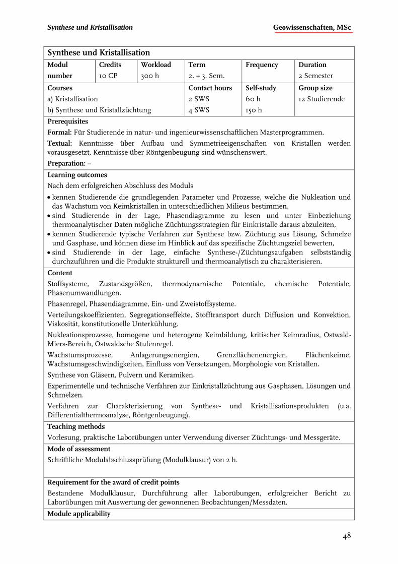
Synthese und Kristallisation Geowissenschaften, MSc
48
Synthese und Kristallisation
Modul
number
Credits
10 CP
Workload
300 h
Term
2. + 3. Sem.
Frequency
Duration
2 Semester
Courses
a) Kristallisation
b) Synthese und Kristallzüchtung
Contact hours
2 SWS
4 SWS
Self-study
60 h
150 h
Group size
12 Studierende
Prerequisites
Formal: Für Studierende in natur- und ingenieurwissenschaftlichen Masterprogrammen.
Textual: Kenntnisse über Aufbau und Symmetrieeigenschaften von Kristallen werden vorausgesetzt, Kenntnisse über Röntgenbeugung sind wünschenswert.
Preparation: –
Learning outcomes
Nach dem erfolgreichen Abschluss des Moduls
kennen Studierende die grundlegenden Parameter und Prozesse, welche die Nukleation und das Wachstum von Keimkristallen in unterschiedlichen Milieus bestimmen,
sind Studierende in der Lage, Phasendiagramme zu lesen und unter Einbeziehung thermoanalytischer Daten mögliche Züchtungsstrategien für Einkristalle daraus abzuleiten,
kennen Studierende typische Verfahren zur Synthese bzw. Züchtung aus Lösung, Schmelze und Gasphase, und können diese im Hinblick auf das spezifische Züchtungsziel bewerten,
sind Studierende in der Lage, einfache Synthese-/Züchtungsaufgaben selbstständig durchzuführen und die Produkte strukturell und thermoanalytisch zu charakterisieren.
Content
Stoffsysteme, Zustandsgrößen, thermodynamische Potentiale, chemische Potentiale, Phasenumwandlungen.
Phasenregel, Phasendiagramme, Ein- und Zweistoffsysteme.
Verteilungskoeffizienten, Segregationseffekte, Stofftransport durch Diffusion und Konvektion, Viskosität, konstitutionelle Unterkühlung.
Nukleationsprozesse, homogene und heterogene Keimbildung, kritischer Keimradius, Ostwald-Miers-Bereich, Ostwaldsche Stufenregel.
Wachstumsprozesse, Anlagerungsenergien, Grenzflächenenergien, Flächenkeime, Wachstumsgeschwindigkeiten, Einfluss von Versetzungen, Morphologie von Kristallen.
Synthese von Gläsern, Pulvern und Keramiken.
Experimentelle und technische Verfahren zur Einkristallzüchtung aus Gasphasen, Lösungen und Schmelzen.
Verfahren zur Charakterisierung von Synthese- und Kristallisationsprodukten (u.a. Differentialthermoanalyse, Röntgenbeugung).
Teaching methods
Vorlesung, praktische Laborübungen unter Verwendung diverser Züchtungs- und Messgeräte.
Mode of assessment
Schriftliche Modulabschlussprüfung (Modulklausur) von 2 h.
Requirement for the award of credit points
Bestandene Modulklausur, Durchführung aller Laborübungen, erfolgreicher Bericht zu Laborübungen mit Auswertung der gewonnenen Beobachtungen/Messdaten.
Module applicability
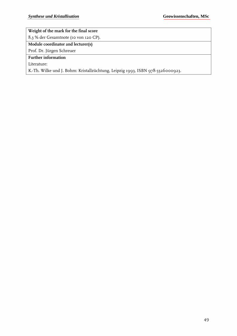
Synthese und Kristallisation Geowissenschaften, MSc
49
Weight of the mark for the final score
8,3 % der Gesamtnote (10 von 120 CP).
Module coordinator and lecturer(s)
Prof. Dr. Jürgen Schreuer
Further information
Literature:
K.-Th. Wilke und J. Bohm: Kristallzüchtung, Leipzig 1993, ISBN 978-3326000923.

Kristallphysik Geowissenschaften, MSc
50
Kristallphysik
Modul
number
Credits
10 CP
Workload
300 h
Term
1. + 2. Sem.
Frequency
Duration
2 Semester
Courses
a) Kristallphysik
b) Physikalische Charakterisierung
Contact hours
3 SWS
4 SWS
Self-study
50 h
145 h
Group size
12 Studierende
Prerequisites
Formal: Für Studierende in natur- und ingenieurwissenschaftlichen Masterprogrammen.
Textual: Kenntnisse über Aufbau und Symmetrieeigenschaften von Kristallen werden vorausgesetzt.
Preparation: –
Learning outcomes
Nach dem erfolgreichen Abschluss des Moduls
kennen Studierende die grundlegenden Konzepte der tensoriellen Kristallphysik und verstehen die Zusammenhänge zwischen der atomaren Struktur von Kristallen und deren thermischen, mechanischen und elektrischen Eigenschaften,
sind Studierende befähigt, Strategien zur vollständigen Bestimmung tensorieller Eigenschaften von anisotropen Medien zu entwickeln,
kennen Studierende geeignete Messverfahren zur Untersuchung thermischer und elektromechanischer Eigenschaften und können entsprechende Messapparaturen nutzen sowie die dafür notwendigen Präparate herstellen,
sind Studierende in der Lage, Messergebnisse kritisch zu hinterfragen, mögliche Fehlerquellen zu diagnostizieren und deren Auswirkungen auf die Resultate zu quantifizieren.
Content
Kristallographische und kristallphysikalische Bezugssysteme.
Zustandsgrößen, thermodynamische Potentiale, Basiseigenschaften.
Nichttensorielle und tensorielle Eigenschaften, Transformationsverhalten.
Einfluss von Symmetrie, Neumannsches Prinzip, Curiesches Prinzip.
Herstellung von Präparaten für Messzwecke (Orientieren, Sägen, Schleifen).
Longitudinal- und Transversaleffekte, Bezugsflächen, Extremwerte von Eigenschaften.
Tensoren 0. Stufe: Dichte und Wärmekapazität, Verfahren zur Bestimmung der Dichte bzw. Wärmekapazität.
Tensoren 1. Stufe: Symmetriereduktion, pyroelektrischer Effekt, Messstrategien, Tensorfläche.
Tensoren 2. Stufe: Symmetriereduktion, Bezugsflächen, symmetrische und antisymmetrische Tensoren, Hauptachsentransformation, Dielektrizitätstensor, Ferroelektrizität, Deformationstensor, thermische Ausdehnung einschließlich der gängigen Messmethoden.
Tensoren 3. Stufe: Tensorfläche, Messstrategien, piezoelektrischer Effekt, Elektrostriktion, Verfahren zur Messung von druckinduzierten Ladungen bzw. feldinduzierten Deformationen.
Tensoren 4. Stufe: Symmetriereduktion, Elastizitätstensoren, Voigt-Notation, Elastostatik, Elastodynamik, Wellenausbreitung in Kristallen, diverse Messmethoden (insbesondere Ultraschallresonanzspektroskopie).
Nichttensorielle Eigenschaften.
Kritische Analyse von Messdaten und deren Aufbereitung für Berichte bzw. Publikationen.
Teaching methods
Vorlesung, praktische Laborübungen an typischen Messgeräten.
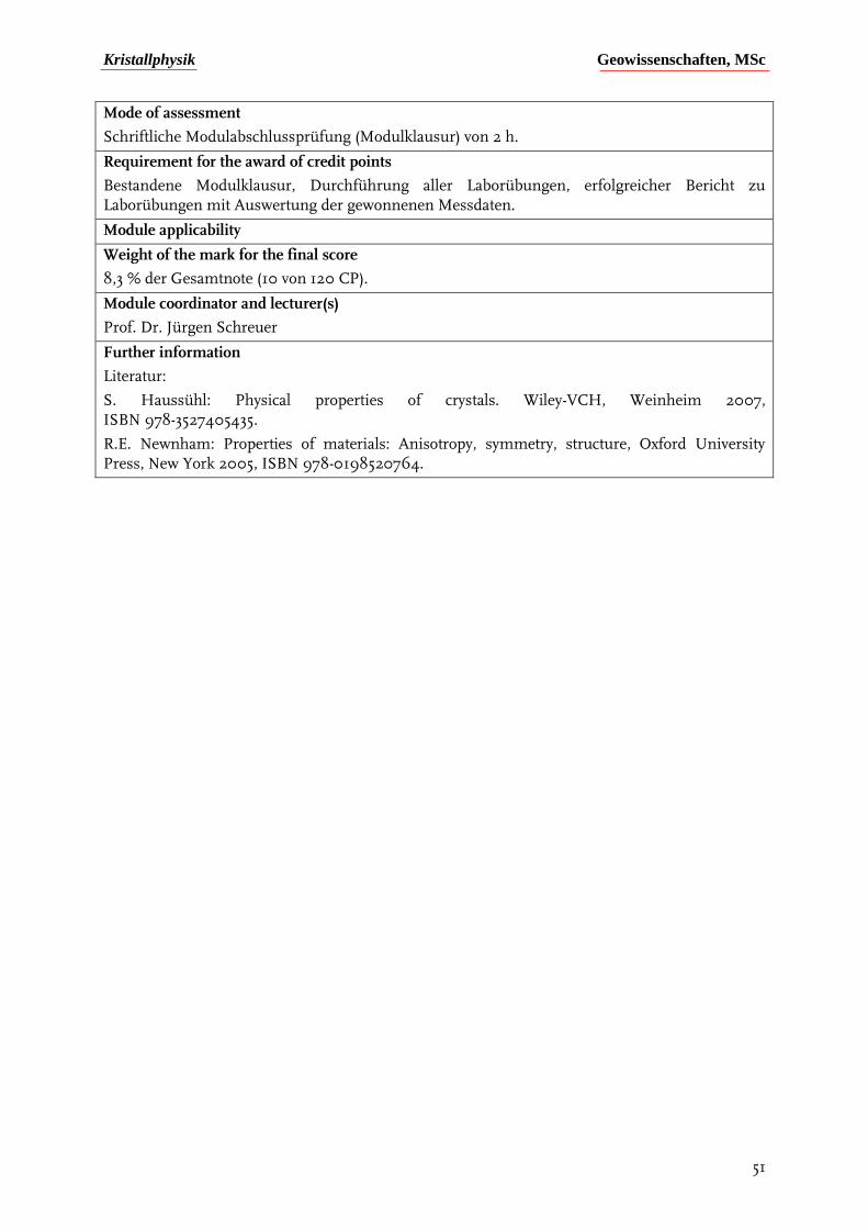
Kristallphysik Geowissenschaften, MSc
51
Mode of assessment
Schriftliche Modulabschlussprüfung (Modulklausur) von 2 h.
Requirement for the award of credit points
Bestandene Modulklausur, Durchführung aller Laborübungen, erfolgreicher Bericht zu Laborübungen mit Auswertung der gewonnenen Messdaten.
Module applicability
Weight of the mark for the final score
8,3 % der Gesamtnote (10 von 120 CP).
Module coordinator and lecturer(s)
Prof. Dr. Jürgen Schreuer
Further information
Literatur:
S. Haussühl: Physical properties of crystals. Wiley-VCH, Weinheim 2007, ISBN 978-3527405435.
R.E. Newnham: Properties of materials: Anisotropy, symmetry, structure, Oxford University Press, New York 2005, ISBN 978-0198520764.
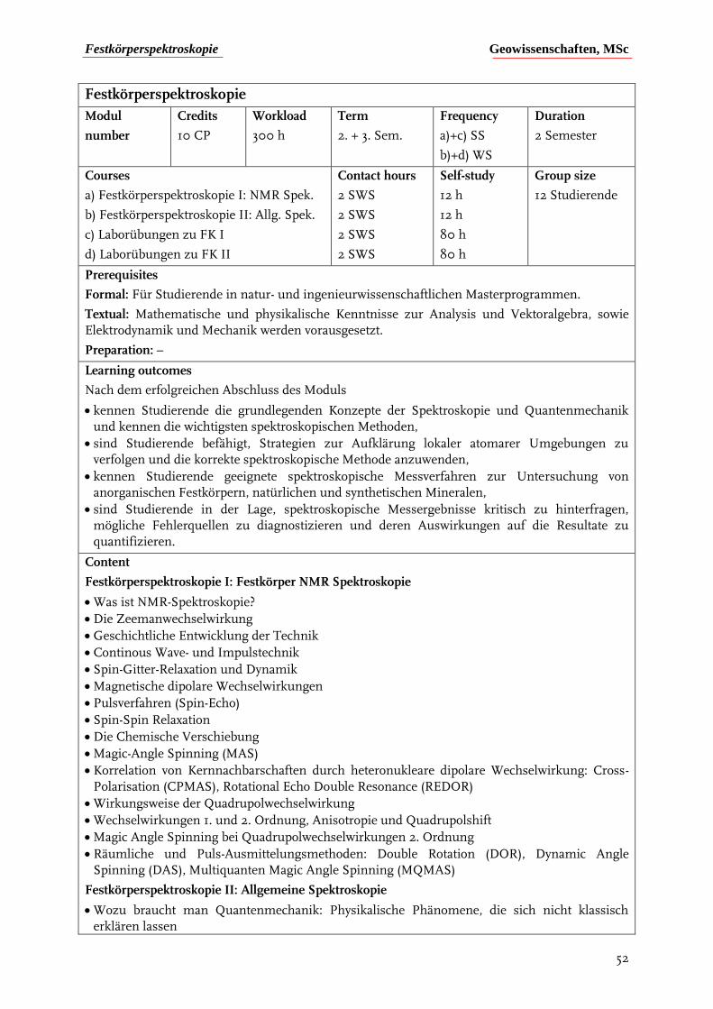
Festkörperspektroskopie Geowissenschaften, MSc
52
Festkörperspektroskopie
Modul
number
Credits
10 CP
Workload
300 h
Term
2. + 3. Sem.
Frequency
a)+c) SS
b)+d) WS
Duration
2 Semester
Courses
a) Festkörperspektroskopie I: NMR Spek.
b) Festkörperspektroskopie II: Allg. Spek.
c) Laborübungen zu FK I
d) Laborübungen zu FK II
Contact hours
2 SWS
2 SWS
2 SWS
2 SWS
Self-study
12 h
12 h
80 h
80 h
Group size
12 Studierende
Prerequisites
Formal: Für Studierende in natur- und ingenieurwissenschaftlichen Masterprogrammen.
Textual: Mathematische und physikalische Kenntnisse zur Analysis und Vektoralgebra, sowie Elektrodynamik und Mechanik werden vorausgesetzt.
Preparation: –
Learning outcomes
Nach dem erfolgreichen Abschluss des Moduls
kennen Studierende die grundlegenden Konzepte der Spektroskopie und Quantenmechanik und kennen die wichtigsten spektroskopischen Methoden,
sind Studierende befähigt, Strategien zur Aufklärung lokaler atomarer Umgebungen zu verfolgen und die korrekte spektroskopische Methode anzuwenden,
kennen Studierende geeignete spektroskopische Messverfahren zur Untersuchung von anorganischen Festkörpern, natürlichen und synthetischen Mineralen,
sind Studierende in der Lage, spektroskopische Messergebnisse kritisch zu hinterfragen, mögliche Fehlerquellen zu diagnostizieren und deren Auswirkungen auf die Resultate zu quantifizieren.
Content
Festkörperspektroskopie I: Festkörper NMR Spektroskopie
Was ist NMR-Spektroskopie?
Die Zeemanwechselwirkung
Geschichtliche Entwicklung der Technik
Continous Wave- und Impulstechnik
Spin-Gitter-Relaxation und Dynamik
Magnetische dipolare Wechselwirkungen
Pulsverfahren (Spin-Echo)
Spin-Spin Relaxation
Die Chemische Verschiebung
Magic-Angle Spinning (MAS)
Korrelation von Kernnachbarschaften durch heteronukleare dipolare Wechselwirkung: Cross-Polarisation (CPMAS), Rotational Echo Double Resonance (REDOR)
Wirkungsweise der Quadrupolwechselwirkung
Wechselwirkungen 1. und 2. Ordnung, Anisotropie und Quadrupolshift
Magic Angle Spinning bei Quadrupolwechselwirkungen 2. Ordnung
Räumliche und Puls-Ausmittelungsmethoden: Double Rotation (DOR), Dynamic Angle Spinning (DAS), Multiquanten Magic Angle Spinning (MQMAS)
Festkörperspektroskopie II: Allgemeine Spektroskopie
Wozu braucht man Quantenmechanik: Physikalische Phänomene, die sich nicht klassisch erklären lassen
Festkörperspektroskopie Geowissenschaften, MSc
53
Plancks Quantelung von Energiezuständen, Welle-Teilchen Dualismus
Wellenfunktion, Hamiltonoperator, Eigenwerte, -funktionen und Schrödinger-Gleichung, Heisenbergsche Unschärferelation
Quantenmechanik einfacher eindimensionaler Systeme
Die elektromagnetische Welle – Aufbau und Polarisation
Wellenlängenbereiche und Anwendung in der Spektroskopie
Intensität und Breite von Spektrallinien
Absorption / Emissionsspektren – Einstein-Koeffizienten
Energieniveaus und Übergangswahrscheinlichkeiten
Rotations- und Schwingungsspektroskopie: Starrer und nicht-starrer Rotator, harmonischer und anharmonischer Oszillator
Auswahlregeln Infrarotspektren, Aufbau moderner Infrarotspektrometer
Raman-Spektroskopie: Rayleighstreuung, Stokes- und Anti-Stokes Linien
Schwingungstypen und Gruppentheorie, Irreduzible Darstellungen, Charaktertafeln, Charaktere, Ordnung, Symmetriespezies, Bestimmung der Schwingungstypen mit Hilfe von Charaktertafeln, Bestimmung von erlaubten und verbotenen Übergängen
Ramanspektren und Aufbau moderner Ramanspektrometer
IR- und -Schwingungsspektren von Mineralen
Elektronenspektroskopie: Ein- und Mehrelektronenatome, Elektronenübergänge, Auswahlregeln, Russell-Saunders Kopplung
Atomabsorptions- und emissionsspektroskopie, Röntgenspektroskopie (XPS, EXAFS)
Die Schwingungsstruktur der Elektronenübergänge: Feinstruktur und Franck-Condon-Prinzip
Fluoreszenz und Phosphoreszenz, Funktion von LASERn
UV-VIS Spektroskopie: Aufbau eines UV-VIS Spektrometers, Kristallfeldtheorie, Molekularorbitaltheorie, d-d Übergänge und Charge-Transfer Übergänge, Termsymbole, Jahn-Teller Verzerrung, Tanabe-Sugano Diagramme
EPR Spektroskopie: Der Elektronen-Zeeman-Term
Elektronenspinwechselwirkungen: Die Nullfeld-Aufspaltung (ZFS)
Elektronen-Kernspinwechselwirkungen: Die Hyperfeinstruktur (HFS)
Aufbau eines EPR cw-Spektrometers: Einkristallspektren und Rotationsdiagramme
Der Mößbauereffekt: Rückstoßfreie Kernresonanzabsorption
Das Mößbauerspektrometer: Ausnutzung des Dopplereffektes
Isomerieverschiebung, Quadrupol- und magnetische Hyperfeinaufspaltung
Typischer Mößbauerkern in den Geowissenschaften: 57Fe
Mößbauerspektren von Mineralen: Bestimmung des Fe2+ / Fe3+ -Verhältnisses
Teaching methods
Vorlesung, praktische Laborübungen an typischen Spektrometern (NMR, IR, UV-VIS).
Mode of assessment
Mündliche Modulabschlußprüfung von 30 min..
Requirement for the award of credit points
Bestandene mündliche Modulabschlußprüfung, Durchführung aller Laborübungen, erfolgreiche Berichte zu Laborübungen mit Auswertung der gewonnenen Messdaten.
Module applicability
Weight of the mark for the final score 8,3 % der Gesamtnote (10 von 120 CP).
Module coordinator and lecturer(s) Dr. Michael Fechtelkord
Further information
Strukturbestimmung Geowissenschaften, MSc
54
Strukturbestimmung
Modul
number
Credits
10 CP
Workload
300 h
Term
2. + 3. Sem.
Frequency
Duration
2 Semester
Courses
a) Strukturbestimmung (Vorlesung)
b) Röntgenbeugung (Übung)
Contact hours
3 SWS
4 SWS
Self-study
75 h
120 h
Group size
12 Studierende
Prerequisites
Formal: Für Studierende in natur- und ingenieurwissenschaftlichen Masterprogrammen.
Textual: Kenntnisse über Aufbau und Symmetrieeigenschaften von Kristallen werden vorausgesetzt, Kenntnisse in der Kristallchemie und der Kristallphysik sind wünschenswert.
Preparation: –
Learning outcomes
Nach dem erfolgreichen Abschluss des Moduls
kennen Studierende die grundlegenden Prinzipien der Symmetrielehre, der Röntgenbeugung und verschiedener Strukturbestimmungsverfahren,
kennen Studierende typische Techniken und Abläufe der Strukturanalyse und können erforderliche Korrekturfaktoren anwenden.
sind Studierende in der Lage, für ein gegebenes Problem eine passende Vorgehensweise auszuwählen und beherrschen in Grundzügen die erforderlichen Computerprogramme.
sind Studierende in der Lage, auf der Basis eines gegebenen Datensatzes eine Kristallstrukturbestimmung selbstständig durchzuführen und die Qualität des Ergebnisses zu beurteilen.
Content
Kristallographische Grundbegriffe, Kristallsysteme, Kristallklassen, Raumgruppen, Bravais-Gitter, translationsbehaftete Symmetrieelemente.
Das reziproke Gitter, Röntgenbeugung, die Braggsche Gleichung, die Ewald-Konstruktion Beugung an Netzebenenscharen.
Erzeugung von Röntgenstrahlung, charakteristische Strahlung, Absorption, Berechnung von Absorptionskoeffizienten.
Wechselwirkung von Röntgenstrahlung mit Materie, der Atomformfaktor.
Der Strukturfaktor, Phasenwinkel.
Auslöschungsgesetze, Zusammenhang von Reflexintensität und Strukturfaktor, Korrekturfaktoren
Polarizationsfaktor, Lorentzfaktor, Absorptionsfaktor, Skalenfaktor, Temperaturfaktor,
Extinktionsfaktor, Häufigkeitsfaktor, Polarisationsfaktor des Monochromators
Die Fouriertransformation, Differenz-Fourier-Synthese
Strukturbestimmungsverfahren, die Schweratommethode, Direkte Methoden, Methode des isomorphen Ersatzes, die Patterson-Methode, Anomale Dispersion
Zwillinge
Strukturverfeinerung, Restraints und Constraints, Qualitätsfaktoren
Darstellung von Kristallstrukturen.
Teaching methods
Vorlesung, Rechenübungen und praktische Laborübungen unter Verwendung von Röntgendiffraktometern.

Strukturbestimmung Geowissenschaften, MSc
55
Mode of assessment
Schriftliche Modulabschlussprüfung (Modulklausur) von 2 h.
Requirement for the award of credit points
Bestandene Modulklausur, Durchführung aller Laborübungen, erfolgreiche Berichte zu Rechenübungen.
Module applicability
Weight of the mark for the final score
8,3 % der Gesamtnote (10 von 120 CP).
Module coordinator and lecturer(s)
Dr. Bernd Marler
Further information
Literatur:
Kleber, Bautsch, Bohm: Einführung in die Kristallographie, Verlag Technik
T. Hahn (ed.): Intern. Tables for Crystallography, Vol. A, D. Reidel Publ. Company
C. Giacovazzo (ed.): Fundamentals of Crystallography, Int. Union of Crystallography Monographs, Band 15, Oxford Science Publications
Analytical methods in rock analysis Geowissenschaften, MSc
56
Analytical methods in rock analysis
Module
number
Credits
5 CP
Workload
150 h
Term
2. + 3. Sem.
Frequency
Each semester
Duration
2 semester
Courses
a) Methods of rock analysis
b) Practicals on rock analysis
Contact hours
2 SWS
2 SWS
Self-study
30 h
60 h
Number of participants
10
Prerequisites
Learning outcomes
After completion of the module the students
• know methods to quantify the chemical content of solid materials.
• can make qualified decisions about which analytical method is best suited for a given analytical problem.
• are able to critically evaluate the results, to analyze possible sources of errors, and their influences on the results.
Content
Lecture in Methods of rock analysis: Fundamentals of electromagnetic rays and interaction with matter. Atomic-Absorption Spectroscopy (AAS), X-ray fluorescence spectroscopy (XRF), Coulorometry, Potentiometric methods, Nuclear Methods (e.g. RBS, NRA), General principles of mass spectrometry and different kinds of mass spectrometry, Laser-Ablation inductively coupled mass spectrometry (LAB-ICP-MS), Secondary Ion Mass Spectroscopy (SIMS).
Sample Preparation Methods
Practicals on rock analysis: Complete chemical analysis of a silicate rock will be carried out, and the errors and uncertainties in the results will be evaluated.
Types of courses
Lecture, practicals
Types of examinations
Written report including the theory behind the operation of the devices, a brief description of the practical experiment and presentation of the results with an estimation of the errors. A discussion of the results.
Prerequisites for earning the credit points
Attendance in the practicals and a passed graded report.
Module applicability
Percentage of the grade for the overall examination
4 %
Head of the module
Dr. Thomas Fockenberg
Literature
Potts: A Handbook of silicate rock analysis; Springer
Potts et al.: Microprobe techniques in the Earth sciences; Springer
Rollinson H.: Using Geochemical Data – evaluation, presentation and interpretation. Prentice Hall Press.
Granger et al.: Instrumental analysis; Oxford university press
Hughes & Hase: Measurements and their uncertainties, Oxford university press
Kingston & Jassie: Introduction to microwave sample preparation; Oxford university pressc

Electron beam microanalysis Geowissenschaften, MSc
57
Electron beam microanalysis
Module
number
Credits
6 CP
Workload
180 h
Term
2. Sem.
Frequency
Annual
Duration
1 semester
Courses
a) Lecture: Electron beam microanalysis
b) Practical exercises on electron beam microanalysis (SEM, CL, EMPA)
Contact hours
2 SWS
2 SWS
Self-study
60 hours
60 hours
Number of participants :
9
Prerequisites
Learning outcomes
After completion of this module the students
• understand the applicability of electron beam microanalytical methods.
• know different kinds of methods (SEM, EMPA, TEM, CL, Auger electron)
• are able to evaluate the strengths and limitations and perform an analysis of errors.
• gained practical experience of diverse electron beam analytical tools.
Content
a) Lecture
Overview of the use of electron beam methods for the analysis of solid materials. Electron – matter interaction (elastic scattering, inelastic scattering, production of X-rays, Auger electrons, and Cathodoluminescence). Construction principles and working of different instruments (TEM, SEM, EMPA, STEM, CL microscopes). Functionality of different parts of the instruments such as pumps, electron optic, generation of electron beams). Analytical methods and interpretation of analytical results (EELS, EBSD, electron optical images, EDX, WDX, diffraction images).
b) Practical exercises
Familiarization with the equipment and their parts. Coating a sample with C or Au. Inserting and extracting a sample holder from the sample chamber under vacuum. Adjusting the electron beam. Navigation on the sample. Use of different detectors (SE, BSE, CL, EBSD) for imaging. Experiments on the effects of accelerating voltage and sample current. Qualitative analysis and identification of minerals with the help of the energy dispersive detectors. Collecting wavelength dispersive spectra in the electron microprobe. Comparison of results from EDX and WDS. Production of element distribution maps. Generation of crystallographic orientation images (SEM).
Conceiving a quantitative analytical program. Determination of peak and background positions, choice of spectrometers, standard materials, counting times and beam parameters (EMPA).
Evaluation of the analyses through the calculation of mineral formulae and estimate of errors.
Types of courses
Lectures and practicals.
Types of examinations
Final examination on the lecture part. Passing this exam is a pre-requisite for participation in the practical exercises.
Prerequisites for earning the credit points
Passing grade in the exam. Active participation in the practical demonstrated through a detailed record of experiments in the lab book.
Module applicability
Percentage of the grade for the overall examination
Electron beam microanalysis Geowissenschaften, MSc
58
5,0 % of the overall grade (6 CP from 120)
Head of the module
Dr. René Hoffmann and Dr. Niels Jöns
Literature
Potts et al.: Microprobe techniques in the Earth sciences; Springer
Loretto (1984): Electron beam analysis of materials. 2nd ed., Springer-Verlag.
Hughes & Hase (2010): Measurements and their uncertainties. 1st ed., Oxford University Press
Goldstein et al. (2018): Scanning electron microscopy and X-ray microanalysis. 4th ed., Plenum Press.
Reed (2005): Electron microprobe analysis and scanning electron microscopy in Geology, 2nd ed., Cambridge University Press.
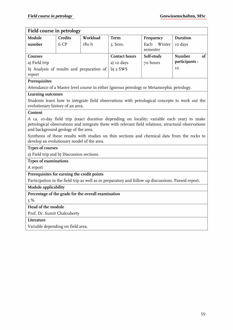
Field course in petrology Geowissenschaften, MSc
59
Field course in petrology
Module
number
Credits
6 CP
Workload
180 h
Term
3. Sem.
Frequency
Each Winter semester
Duration
10 days
Courses
a) Field trip
b) Analysis of results and preparation of report
Contact hours
a) 10 days
b) 2 SWS
Self-study
70 hours
Number of participants :
10
Prerequisites
Attendance of a Master level course in either Igneous petrology or Metamorphic petrology.
Learning outcomes
Students learn how to integrate field observations with petrological concepts to work out the evolutionary history of an area.
Content
A ca. 10-day field trip (exact duration depending on locality; variable each year) to make petrological observations and integrate these with relevant field relations, structural observations and background geology of the area.
Synthesis of these results with studies on thin sections and chemical data from the rocks to develop an evolutionary model of the area.
Types of courses
a) Field trip and b) Discussion sections.
Types of examinations
A report
Prerequisites for earning the credit points
Participation in the field trip as well as in preparatory and follow up discussions. Passed report.
Module applicability
Percentage of the grade for the overall examination
5 %
Head of the module
Prof. Dr. Sumit Chakraborty
Literature
Variable depending on field area.
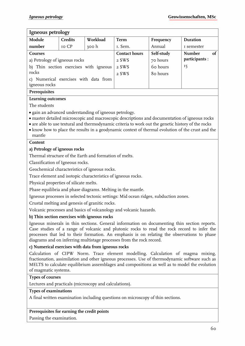
Igneous petrology Geowissenschaften, MSc
60
Igneous petrology
Module
number
Credits
10 CP
Workload
300 h
Term
1. Sem.
Frequency
Annual
Duration
1 semester
Courses
a) Petrology of igneous rocks
b) Thin section exercises with igneous rocks
c) Numerical exercises with data from igneous rocks
Contact hours
2 SWS
2 SWS
2 SWS
Self-study
70 hours
60 hours
80 hours
Number of participants :
15
Prerequisites
Learning outcomes
The students
gain an advanced understanding of igneous petrology.
master detailed microscopic and macroscopic descriptions and documentation of igneous rocks
are able to use textural and thermodynamic criteria to work out the genetic history of the rocks
know how to place the results in a geodynamic context of thermal evolution of the crust and the mantle
Content
a) Petrology of igneous rocks
Thermal structure of the Earth and formation of melts.
Classification of Igneous rocks.
Geochemical characteristics of igneous rocks.
Trace element and isotopic characteristics of igneous rocks.
Physical properties of silicate melts.
Phase equilibria and phase diagrams. Melting in the mantle.
Igneous processes in selected tectonic settings: Mid ocean ridges, subduction zones.
Crustal melting and genesis of granitic rocks.
Volcanic processes and basics of volcanology and volcanic hazards.
b) Thin section exercises with igneous rocks
Igneous minerals in thin sections. General information on documenting thin section reports. Case studies of a range of volcanic and plutonic rocks to read the rock record to infer the processes that led to their formation. An emphasis is on relating the observations to phase diagrams and on inferring multistage processes from the rock record.
c) Numerical exercises with data from igneous rocks
Calculation of CIPW Norm. Trace element modelling. Calculation of magma mixing, fractionation, assimilation and other igneous processes. Use of thermodynamic software such as MELTS to calculate equilibrium assemblages and compositions as well as to model the evolution of magmatic systems.
Types of courses
Lectures and practicals (microscopy and calculations).
Types of examinations
A final written examination including questions on microscopy of thin sections.
Prerequisites for earning the credit points
Passing the examination.

Igneous petrology Geowissenschaften, MSc
61
Module applicability
Percentage of the grade for the overall examination
8 % of the overall grade (10 CP from 120)
Head of the module
Prof. Dr. Sumit Chakraborty
Literature
A.R. Philpotts, J.J. Ague (2009): Principles of igneous and metamorphic petrology. Cambridge University Press. ISBN 978-0-521-88006-0
J.D. Winter (2014): Principles of igneous and metamorphic petrology. Pearson Education. ISBN 978-1-292-02153-9
R. Gill (2010) Igneous rocks and processes – a practical guide. Wiley Blackwell. ISBN 978-0-6320-6377-2.
M. Wilson (1997) Igneous petrogenesis – A global tectonic approach. Chapman & Hall. ISBN 0 412 53310 3.
L.A. Raymond (1995) The study of igneous, sedimentary and metamoprphic rocks. Wm. C. Brown Communications Inc. ISBN 0-697-00190-3.
McBirney, A. (2006) Igneous Petrology. Jones & Bartlett Publ. ISBN 10: 0763734489.
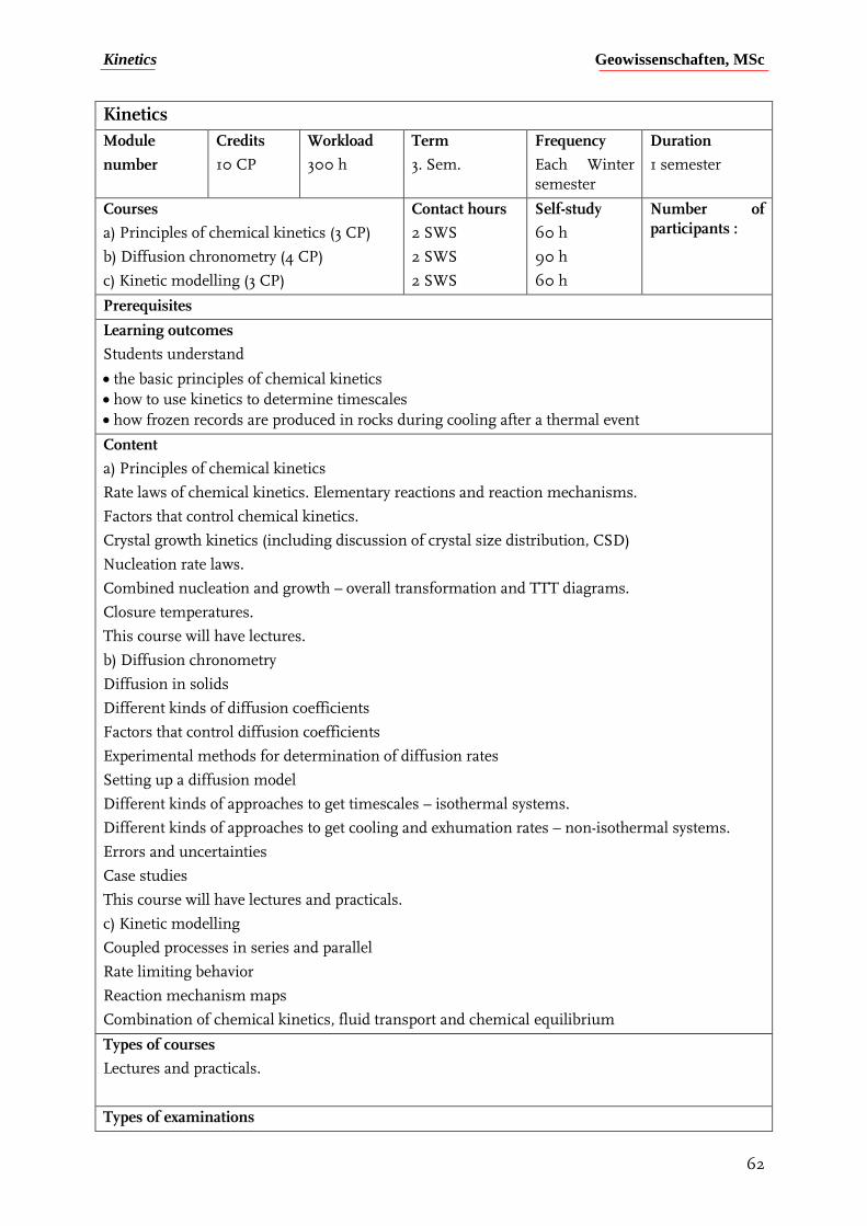
Kinetics Geowissenschaften, MSc
62
Kinetics
Module
number
Credits
10 CP
Workload
300 h
Term
3. Sem.
Frequency
Each Winter semester
Duration
1 semester
Courses
a) Principles of chemical kinetics (3 CP)
b) Diffusion chronometry (4 CP)
c) Kinetic modelling (3 CP)
Contact hours
2 SWS
2 SWS
2 SWS
Self-study
60 h
90 h
60 h
Number of participants :
Prerequisites
Learning outcomes
Students understand
the basic principles of chemical kinetics
how to use kinetics to determine timescales
how frozen records are produced in rocks during cooling after a thermal event
Content
a) Principles of chemical kinetics
Rate laws of chemical kinetics. Elementary reactions and reaction mechanisms.
Factors that control chemical kinetics.
Crystal growth kinetics (including discussion of crystal size distribution, CSD)
Nucleation rate laws.
Combined nucleation and growth – overall transformation and TTT diagrams.
Closure temperatures.
This course will have lectures.
b) Diffusion chronometry
Diffusion in solids
Different kinds of diffusion coefficients
Factors that control diffusion coefficients
Experimental methods for determination of diffusion rates
Setting up a diffusion model
Different kinds of approaches to get timescales – isothermal systems.
Different kinds of approaches to get cooling and exhumation rates – non-isothermal systems.
Errors and uncertainties
Case studies
This course will have lectures and practicals.
c) Kinetic modelling
Coupled processes in series and parallel
Rate limiting behavior
Reaction mechanism maps
Combination of chemical kinetics, fluid transport and chemical equilibrium
Types of courses
Lectures and practicals.
Types of examinations
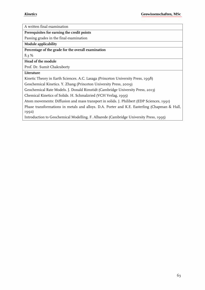
Kinetics Geowissenschaften, MSc
63
A written final examination
Prerequisites for earning the credit points
Passing grades in the final examination
Module applicability
Percentage of the grade for the overall examination
8,3 %
Head of the module
Prof. Dr. Sumit Chakraborty
Literature
Kinetic Theory in Earth Sciences. A.C. Lasaga (Princeton University Press, 1998)
Geochemical Kinetics. Y. Zhang (Princeton University Press, 2009)
Geochemical Rate Models. J. Donald Rimstidt (Cambridge University Press, 2013)
Chemical Kinetics of Solids. H. Schmalzried (VCH Verlag, 1995)
Atom movements: Diffusion and mass transport in solids. J. Philibert (EDP Sciences, 1991)
Phase transformations in metals and alloys. D.A. Porter and K.E. Easterling (Chapman & Hall, 1992)
Introduction to Geochemical Modelling. F. Albarede (Cambridge University Press, 1995)
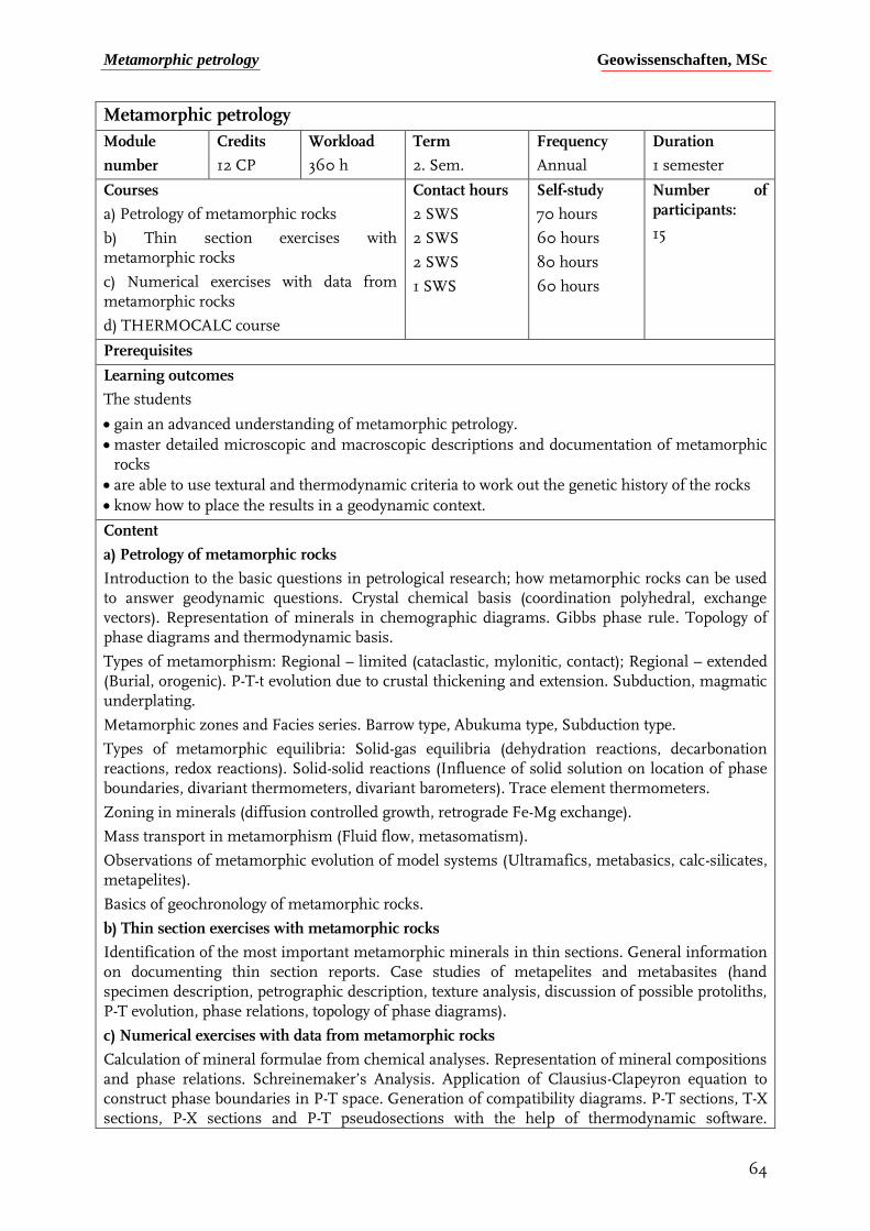
Metamorphic petrology Geowissenschaften, MSc
64
Metamorphic petrology
Module
number
Credits
12 CP
Workload
360 h
Term
2. Sem.
Frequency
Annual
Duration
1 semester
Courses
a) Petrology of metamorphic rocks
b) Thin section exercises with metamorphic rocks
c) Numerical exercises with data from metamorphic rocks
d) THERMOCALC course
Contact hours
2 SWS
2 SWS
2 SWS
1 SWS
Self-study
70 hours
60 hours
80 hours
60 hours
Number of participants:
15
Prerequisites
Learning outcomes
The students
gain an advanced understanding of metamorphic petrology.
master detailed microscopic and macroscopic descriptions and documentation of metamorphic rocks
are able to use textural and thermodynamic criteria to work out the genetic history of the rocks
know how to place the results in a geodynamic context.
Content
a) Petrology of metamorphic rocks
Introduction to the basic questions in petrological research; how metamorphic rocks can be used to answer geodynamic questions. Crystal chemical basis (coordination polyhedral, exchange vectors). Representation of minerals in chemographic diagrams. Gibbs phase rule. Topology of phase diagrams and thermodynamic basis.
Types of metamorphism: Regional – limited (cataclastic, mylonitic, contact); Regional – extended (Burial, orogenic). P-T-t evolution due to crustal thickening and extension. Subduction, magmatic underplating.
Metamorphic zones and Facies series. Barrow type, Abukuma type, Subduction type.
Types of metamorphic equilibria: Solid-gas equilibria (dehydration reactions, decarbonation reactions, redox reactions). Solid-solid reactions (Influence of solid solution on location of phase boundaries, divariant thermometers, divariant barometers). Trace element thermometers.
Zoning in minerals (diffusion controlled growth, retrograde Fe-Mg exchange).
Mass transport in metamorphism (Fluid flow, metasomatism).
Observations of metamorphic evolution of model systems (Ultramafics, metabasics, calc-silicates, metapelites).
Basics of geochronology of metamorphic rocks.
b) Thin section exercises with metamorphic rocks
Identification of the most important metamorphic minerals in thin sections. General information on documenting thin section reports. Case studies of metapelites and metabasites (hand specimen description, petrographic description, texture analysis, discussion of possible protoliths, P-T evolution, phase relations, topology of phase diagrams).
c) Numerical exercises with data from metamorphic rocks
Calculation of mineral formulae from chemical analyses. Representation of mineral compositions and phase relations. Schreinemaker’s Analysis. Application of Clausius-Clapeyron equation to construct phase boundaries in P-T space. Generation of compatibility diagrams. P-T sections, T-X sections, P-X sections and P-T pseudosections with the help of thermodynamic software.
Metamorphic petrology Geowissenschaften, MSc
65
Interpretation of the results using examples from real metamorphic rocks. Geothermobarometric calculations. Derivation of P-T conditions of formation of rocks on the basis of P-T grids.
d) THERMOCALC course
Advanced pseudosection modelling course for more complex model systems involving solid solutions, based on case studies in metabasic rocks.
Types of courses
Lectures and practicals (microscopy and calculations).
Types of examinations
Graded final report. Each individual makes microscopic observations on a sample, interpret the results and carry out numerical calculations associated with the observations.
Prerequisites for earning the credit points
Report with passing grade.
Module applicability
Percentage of the grade for the overall examination
10 % of the overall grade (12 CP from 120)
Module coordinator and lecturer(s)
Dr. Hans-Peter Schertl, Dr. Niels Jöns and Prof. Annika Dziggel (Ph.D.)
Literature
F.S. Spear (1995); Metamorphic phase equilibria and pressure-temperature-time paths. Mineralogical Society of America Monograph. Washington DC. ISBN 0-939950-34-0
A.R. Philpotts, J.J. Ague (2009): Principles of igneous and metamorphic petrology. Cambridge University Press. ISBN 978-0-521-88006-0
J.D. Winter (2014): Principles of igneous and metamorphic petrology. Pearson Education. ISBN 978-1-292-02153-9
D. Turcotte, G. Schubert (2014): Geodynamics. Cambridge University Press. ISBN 978-1-107-00653-9
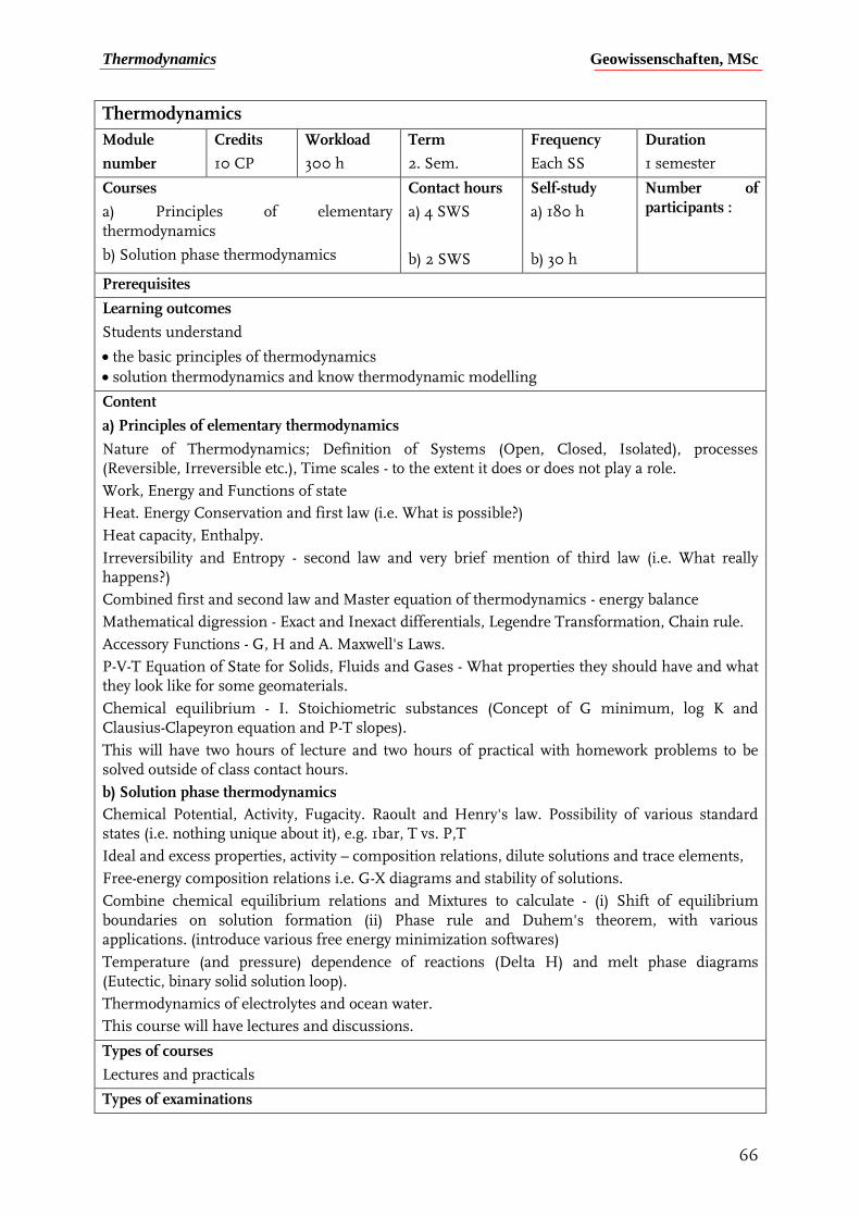
Thermodynamics Geowissenschaften, MSc
66
Thermodynamics
Module
number
Credits
10 CP
Workload
300 h
Term
2. Sem.
Frequency
Each SS
Duration
1 semester
Courses
a) Principles of elementary thermodynamics
b) Solution phase thermodynamics
Contact hours
a) 4 SWS
b) 2 SWS
Self-study
a) 180 h
b) 30 h
Number of participants :
Prerequisites
Learning outcomes
Students understand
the basic principles of thermodynamics
solution thermodynamics and know thermodynamic modelling
Content
a) Principles of elementary thermodynamics
Nature of Thermodynamics; Definition of Systems (Open, Closed, Isolated), processes (Reversible, Irreversible etc.), Time scales - to the extent it does or does not play a role.
Work, Energy and Functions of state
Heat. Energy Conservation and first law (i.e. What is possible?)
Heat capacity, Enthalpy.
Irreversibility and Entropy - second law and very brief mention of third law (i.e. What really happens?)
Combined first and second law and Master equation of thermodynamics - energy balance
Mathematical digression - Exact and Inexact differentials, Legendre Transformation, Chain rule.
Accessory Functions - G, H and A. Maxwell's Laws.
P-V-T Equation of State for Solids, Fluids and Gases - What properties they should have and what they look like for some geomaterials.
Chemical equilibrium - I. Stoichiometric substances (Concept of G minimum, log K and Clausius-Clapeyron equation and P-T slopes).
This will have two hours of lecture and two hours of practical with homework problems to be solved outside of class contact hours.
b) Solution phase thermodynamics
Chemical Potential, Activity, Fugacity. Raoult and Henry's law. Possibility of various standard states (i.e. nothing unique about it), e.g. 1bar, T vs. P,T
Ideal and excess properties, activity – composition relations, dilute solutions and trace elements,
Free-energy composition relations i.e. G-X diagrams and stability of solutions.
Combine chemical equilibrium relations and Mixtures to calculate - (i) Shift of equilibrium boundaries on solution formation (ii) Phase rule and Duhem's theorem, with various applications. (introduce various free energy minimization softwares)
Temperature (and pressure) dependence of reactions (Delta H) and melt phase diagrams (Eutectic, binary solid solution loop).
Thermodynamics of electrolytes and ocean water.
This course will have lectures and discussions.
Types of courses
Lectures and practicals
Types of examinations
Thermodynamics Geowissenschaften, MSc
67
A written final examination
Prerequisites for earning the credit points
Passing grade in the final examination
Module applicability
Percentage of the grade for the overall examination
8,3 %
Head of the module
Prof. Dr. Sumit Chakraborty
Literature
Thermodynamics of natural systems – Theory and Applications in Geochemistry and Environmental Sciences; G.M. Anderson (Cambridge University Press, 2017)
Thermodynamics in Earth and Planetary Sciences; J. Ganguly (Springer Verlag, 2019)
Thermodynamics of the Earth and Planets; Alberto Patino-Douce (Cambridge University Press, 2011)
Physical Chemistry; G.K. Vemulapalli (Prentice Hall International, 1993)
Applied Mineralogical Thermodynamics; N.D. Chatterjee (Springer Verlag, 1991)
Mixtures and Mineral Reactions; J. Ganguly and S.K. Saxena (Springer Verlag, 1987)
The Principles of Chemical Equilibrium; K. Denbigh (Cambridge University Press, 1984)
Field course in tectonics and resources Geowissenschaften, MSc
68
Field course in tectonics and resources
Modul-Nr. Credits
10 CP
Workload
300 h
Term
2. + 3. Sem.
Frequency
Annual
Duration
10 days
Courses
a) Pre-field course seminar
b) Field course
Contact hours
1 SWS
~10 days
Self-study
70 hours
140 hours
Group size:
14 students
Prerequisites
Learning outcomes
Upon successful completion of this module, the students
know how to document and interpret structural and petrological data.
are able to integrate field observations with theoretical knowledge in tectonics and/or economic geology
Content
The content and exact duration of the field course depend on the field area, which is variable each year (Scotland, South Africa, …). The field course is preceded by a seminar. The aim of this field course is to train the student's field skills in tectonics and economic geology, and to combine theoretical knowledge with field observations. The field course may include small mapping projects and visits to open pit and underground mines.
Types of courses
Field trip, seminar.
Types of examinations
Report.
Requirements for the award of credit points
Participation in the field trip and seminar. Passing grade for the report.
Module applicability
Weight of the mark for the final score
8,3 % (10/120 CP)
Module coordinator and lecturer(s)
Prof. Annika Dziggel (Ph.D), Dr. Sara Wassmann
Other information
Relevant literature will be presented at the beginning of each course.
Economic geology II Geowissenschaften, MSc
69
Economic geology II Modul-Nr. Credits
10 CP
Workload
300 h
Term
1. + 2. Sem.
Frequency
WS, SS
Duration
2 Semester
Courses
a) Metallic mineral deposits
b) Non-metallic mineral deposits
c) Research project on ore deposits
Contact hours
2 SWS
1 SWS
3 SWS
Self-study
70 hours
30 hours
110 hours
Group size:
20 students
Prerequisites
Learning outcomes
Upon successful completion of this module, the students
have an in-depth understanding on the processes of formation of metallic and non-metallic mineral deposits and their different geodynamic settings.
are able to identify and document the mineralogical and textural characteristics of a wide range of deposit types.
know how to evaluate the conditions and processes of element enrichment using a variety of analytical techniques as well as whole rock and mineral-chemical data.
Content
Metallic mineral deposits: Introduction to ore forming processes, genetic concepts and classifications. Conceptual difference between mineral resources and ore reserves; economic aspects. Magmatic(-hydrothermal) ore forming systems: ortho-magmatic deposits, deposits related to granites, Cu-porphyries, ore deposits in mid-ocean ridges and ophiolites. Hydrothermal ore-forming systems related to metamorphic processes; ore deposits in supergene and sedimentary settings.
Non-metallic mineral deposits: Introduction into the use and properties of industrial minerals, earths and rocks, salt and gemstones (diamond only).
Research project on ore deposits: This course emcompasses the guided independent study of well-characterized hydrothermal ore deposits using hand specimens, thin- and polished sections and a range of whole rock and mineral-chemical data. This course introduces students to research-oriented learning and is aimed at preparing the students for their Master projects.
Types of courses
Lectures, practicals, project work in small teams
Types of examinations
Written examination on the contents of courses a) and b); extended abstract and oral presentation in c).
Requirements for the award of credit points
Passing grade for the written examination and extended abstract/oral presentation.
Module applicability
Weight of the mark for the final score
8,3 % (10/120 CP)
Module coordinator and lecturer(s)
Prof. Annika Dziggel (Ph.D), Dr. Sara Wassmann
Other information
Relevant literature will be presented at the beginning of each course.
Economic geology I Geowissenschaften, MSc
70
Economic geology I
Module number
Credits
10 CP
Workload
300 h
Term
1 + 2.
Frequency
Starts each Winter term
Duration
2 terms
Courses
(a) Petroleum geology I (Erdölgeologie I)
(b) Petroleum geology II (Erdölgeologie II)
(c) Field trip (Geländeübung)
Contact hours
2 SWS
2 SWS
1 D
Self-Study
75 hrs
120 hrs
35 hrs
Group size
12-20 Students
Prerequisites
Students enrolled in a Geosciences Master-Program
Learning outcomes
The module consists of a winter-term lecture (a), a summer-term lecture (b) and a summer term field trip (c).
Module part (a): The assessment center exercise aims at communicative interaction and gaining/deepening „soft-skills“ (team work, resilience to challenging time vs. content preparations, concept selection, short presentation, facing a managerial board, staying in control of a meeting, addressing challenging questions constructively and authentically).
Students gain academic level knowledge and applied competences to gather, interpret and rank such reservoirs:
in their context of primary depositional environment, its fundamental controls on global, regional and local scale.
using systemically relevant geogenic alteration factors with positive and/or negative consequences on the reservoir properties and their economic relevance.
executing analysis, interpretation and assessment of pore fluids with respect to their geo-heritage and economic value.
Module part (b): lecture in petroleum geology II: building on (a) and taught for deepening regional geological knowledge with respect to regions with economically relevant subsurface reservoirs. Based on published data, gathering, interpreting and assessing subsurface data forms the core of the student learning. The repetitive evaluation of different regions in the context of the subsurface systemic concept learned in petroleum geology I enables the acquisition of skills to consistently apply prior knowledge and build portfolios differentiating between analogous and unique geological systems. The students gain/learn:
systemic competencies of applying the competences of (a) in a different regional geo-context.
global and regional geological knowledge, analogous occurrences of subsurface architectures versus unique settings and their characteristics.
risks and opportunities derived from analogous versus unique settings, specifically with respect to economic exploration, development and production of the subsurface reservoir.
risk minimization in previously unknown regional settings through the use of analogues in the competency context of analysis – recollection – application – assessment.
Module part (b) is supplemented by an offering of a ½ day assessment center exercise. Participation is voluntary.
Module part (c), field trip: Conducted in the border region of the Netherlands, Lower Saxony and North Rhine-Westphalia. The field trip aims at acquiring the practical skills to combine prior knowledge gained in other field trips, prior regional geological knowledge and the economical geological skills of the lectures. As a result, a new/adjusted/different/professionally relevant assessment of the area is achieved and learning for later work life is performed.
The students learn the practical relevance of the theoretical systemic knowledge acquired in (a)
Economic geology I Geowissenschaften, MSc
71
and (b).
The students learn to integrate prior knowledge of fieldwork within the context of subsurface reservoir interpretation.
The students gather, describe, assess and interpret the outcrops based on rock samples taken.
The students integrate for each outcrop the new insights with those from previous outcrops.
They form, then deepen or revise hypothesis and build a regional to subregional interpretation framework.
They achieve a systemic and economic assessment of existing subsurface reservoirs in the region and their past, current and future utilization.
Digitalization: The relevance and importance of geological modeling of sedimentary basins, subsurface porous network flow modeling and economic assessments are introduced with respect to exemplary software packages. Digital interpretation methods, based on prior manual preparation of data and geological thinking, are taught. The importance of AI and ML (artificial intelligence/machine learning) methods for the consistent processing of large geological data sets, specifically in the context of subsurface reservoirs are discussed. Example data sets and scenarios are used in both economic and geotechnical exercises. Software is not being developed in this course.
Content
One lecture date is used for a practical in-field exercise within the vicinity of the University. Interactively the acquired competences are applied, practiced and thereby deepened.
Module part (a), lecture in petroleum geology I:
Presentation, questioning and feedback methods in English language
- The petroleum system and its controls - Sediments and facies - Reservoir petrology, petrophysics - Pore fluids - Reservoir fluid properties through time - Modelling - Assessment center (optional) Petroleum geology II:
- Repetition: Petroleum system concept and controls - Economic and regional geology Field trip:
- Petroleum System Emsland - Bad Bentheim: sediments, stratigraphy, geological overview - Outcrops - Production units, history, economic importance - Composing an integrated geo-economic concept on the petroleum systems of the Emsland,
integrated interpretation
Teaching methods
Lecture, integrated exercises and field trip
Mode of assessment
One final written exam on (a) and (b) lectures combined, report on the field trip
Requirement for the award of credit points
Written exam: Sufficient level result (“Ausreichend”), successful participation in the field trip
Module applicability
not applicable
Weight of the mark for the final score

Economic geology I Geowissenschaften, MSc
72
8,3 % of final M.Sc. score (10 of 120 CP)
Module coordinator and lecturer(s)
Dr. Olaf Podlaha
Further information
Literature
Textbook recommendations (English) for Lecture Petroleum geology I (self-studies, see timetable)
Detailed/Extensive material for each lecture (copies of all slides, exercise material)
Pending presenting students sign-off, material presented by students is shared
Detailed documentation for the field trip
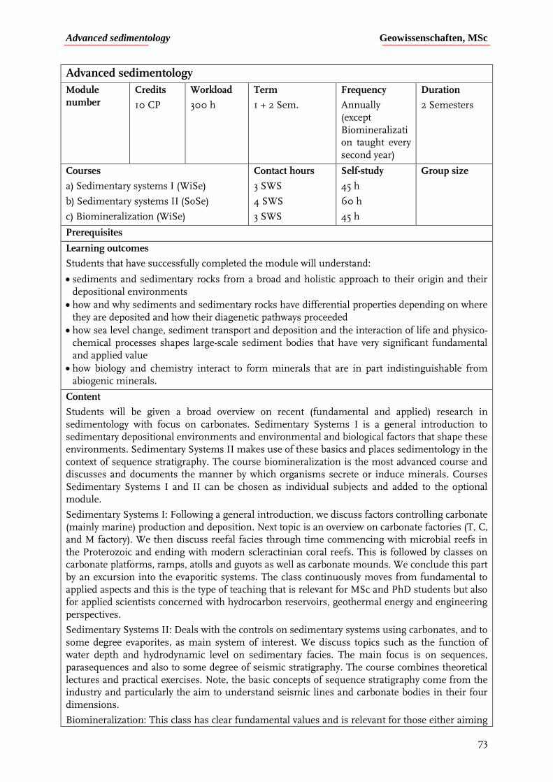
Advanced sedimentology Geowissenschaften, MSc
73
Advanced sedimentology
Module number
Credits
10 CP
Workload
300 h
Term
1 + 2 Sem.
Frequency
Annually (except Biomineralization taught every second year)
Duration
2 Semesters
Courses
a) Sedimentary systems I (WiSe)
b) Sedimentary systems II (SoSe)
c) Biomineralization (WiSe)
Contact hours
3 SWS
4 SWS
3 SWS
Self-study
45 h
60 h
45 h
Group size
Prerequisites
Learning outcomes
Students that have successfully completed the module will understand:
sediments and sedimentary rocks from a broad and holistic approach to their origin and their depositional environments
how and why sediments and sedimentary rocks have differential properties depending on where they are deposited and how their diagenetic pathways proceeded
how sea level change, sediment transport and deposition and the interaction of life and physico-chemical processes shapes large-scale sediment bodies that have very significant fundamental and applied value
how biology and chemistry interact to form minerals that are in part indistinguishable from abiogenic minerals.
Content
Students will be given a broad overview on recent (fundamental and applied) research in sedimentology with focus on carbonates. Sedimentary Systems I is a general introduction to sedimentary depositional environments and environmental and biological factors that shape these environments. Sedimentary Systems II makes use of these basics and places sedimentology in the context of sequence stratigraphy. The course biomineralization is the most advanced course and discusses and documents the manner by which organisms secrete or induce minerals. Courses Sedimentary Systems I and II can be chosen as individual subjects and added to the optional module.
Sedimentary Systems I: Following a general introduction, we discuss factors controlling carbonate (mainly marine) production and deposition. Next topic is an overview on carbonate factories (T, C, and M factory). We then discuss reefal facies through time commencing with microbial reefs in the Proterozoic and ending with modern scleractinian coral reefs. This is followed by classes on carbonate platforms, ramps, atolls and guyots as well as carbonate mounds. We conclude this part by an excursion into the evaporitic systems. The class continuously moves from fundamental to applied aspects and this is the type of teaching that is relevant for MSc and PhD students but also for applied scientists concerned with hydrocarbon reservoirs, geothermal energy and engineering perspectives.
Sedimentary Systems II: Deals with the controls on sedimentary systems using carbonates, and to some degree evaporites, as main system of interest. We discuss topics such as the function of water depth and hydrodynamic level on sedimentary facies. The main focus is on sequences, parasequences and also to some degree of seismic stratigraphy. The course combines theoretical lectures and practical exercises. Note, the basic concepts of sequence stratigraphy come from the industry and particularly the aim to understand seismic lines and carbonate bodies in their four dimensions.
Biomineralization: This class has clear fundamental values and is relevant for those either aiming
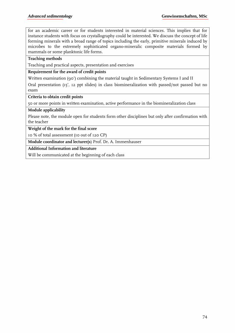
Advanced sedimentology Geowissenschaften, MSc
74
for an academic career or for students interested in material sciences. This implies that for instance students with focus on crystallography could be interested. We discuss the concept of life forming minerals with a broad range of topics including the early, primitive minerals induced by microbes to the extremely sophisticated organo-mineralic composite materials formed by mammals or some planktonic life forms.
Teaching methods
Teaching and practical aspects, presentation and exercises
Requirement for the award of credit points
Written examination (90’) combining the material taught in Sedimentary Systems I and II
Oral presentation (15’, 12 ppt slides) in class biomineralization with passed/not passed but no exam
Criteria to obtain credit points
50 or more points in written examination, active performance in the biomineralization class
Module applicability
Please note, the module open for students form other disciplines but only after confirmation with the teacher
Weight of the mark for the final score
10 % of total assessment (10 out of 120 CP)
Module coordinator and lecturer(s) Prof. Dr. A. Immenhauser
Additional Information and literature
Will be communicated at the beginning of each class
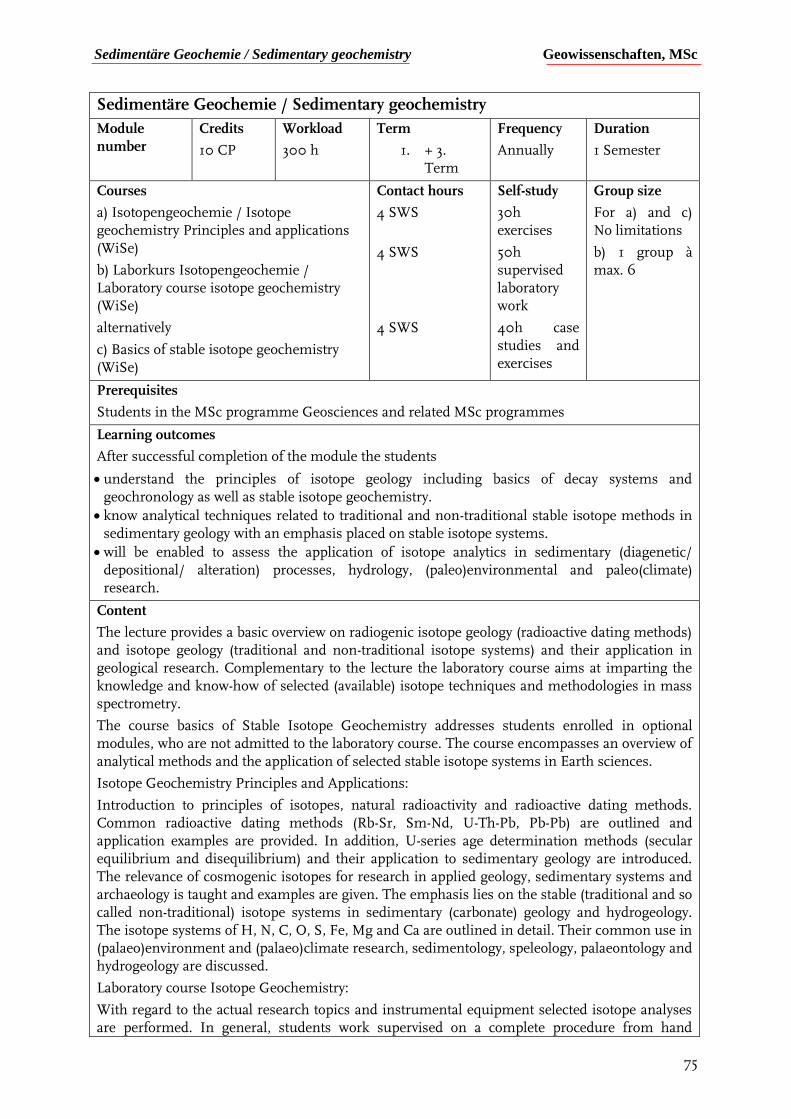
Sedimentäre Geochemie / Sedimentary geochemistry Geowissenschaften, MSc
75
Sedimentäre Geochemie / Sedimentary geochemistry
Module number
Credits
10 CP
Workload
300 h
Term
1. + 3. Term
Frequency
Annually
Duration
1 Semester
Courses
a) Isotopengeochemie / Isotope geochemistry Principles and applications (WiSe)
b) Laborkurs Isotopengeochemie / Laboratory course isotope geochemistry (WiSe)
alternatively
c) Basics of stable isotope geochemistry (WiSe)
Contact hours
4 SWS
4 SWS
4 SWS
Self-study
30h exercises
50h supervised laboratory work
40h case studies and exercises
Group size
For a) and c) No limitations
b) 1 group à max. 6
Prerequisites
Students in the MSc programme Geosciences and related MSc programmes
Learning outcomes
After successful completion of the module the students
understand the principles of isotope geology including basics of decay systems and geochronology as well as stable isotope geochemistry.
know analytical techniques related to traditional and non-traditional stable isotope methods in sedimentary geology with an emphasis placed on stable isotope systems.
will be enabled to assess the application of isotope analytics in sedimentary (diagenetic/ depositional/ alteration) processes, hydrology, (paleo)environmental and paleo(climate) research.
Content
The lecture provides a basic overview on radiogenic isotope geology (radioactive dating methods) and isotope geology (traditional and non-traditional isotope systems) and their application in geological research. Complementary to the lecture the laboratory course aims at imparting the knowledge and know-how of selected (available) isotope techniques and methodologies in mass spectrometry.
The course basics of Stable Isotope Geochemistry addresses students enrolled in optional modules, who are not admitted to the laboratory course. The course encompasses an overview of analytical methods and the application of selected stable isotope systems in Earth sciences.
Isotope Geochemistry Principles and Applications:
Introduction to principles of isotopes, natural radioactivity and radioactive dating methods. Common radioactive dating methods (Rb-Sr, Sm-Nd, U-Th-Pb, Pb-Pb) are outlined and application examples are provided. In addition, U-series age determination methods (secular equilibrium and disequilibrium) and their application to sedimentary geology are introduced. The relevance of cosmogenic isotopes for research in applied geology, sedimentary systems and archaeology is taught and examples are given. The emphasis lies on the stable (traditional and so called non-traditional) isotope systems in sedimentary (carbonate) geology and hydrogeology. The isotope systems of H, N, C, O, S, Fe, Mg and Ca are outlined in detail. Their common use in (palaeo)environment and (palaeo)climate research, sedimentology, speleology, palaeontology and hydrogeology are discussed.
Laboratory course Isotope Geochemistry:
With regard to the actual research topics and instrumental equipment selected isotope analyses are performed. In general, students work supervised on a complete procedure from hand
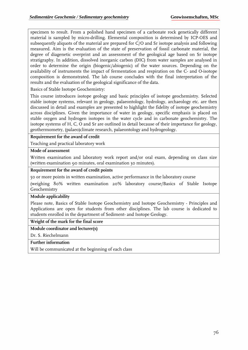
Sedimentäre Geochemie / Sedimentary geochemistry Geowissenschaften, MSc
76
specimen to result. From a polished hand specimen of a carbonate rock genetically different material is sampled by micro-drilling. Elemental composition is determined by ICP-OES and subsequently aliquots of the material are prepared for C/O and Sr isotope analysis and following measured. Aim is the evaluation of the state of preservation of fossil carbonate material, the degree of diagenetic overprint and an assessment of the geological age based on Sr isotope stratigraphy. In addition, dissolved inorganic carbon (DIC) from water samples are analysed in order to determine the origin (biogenic/abiogenic) of the water sources. Depending on the availability of instruments the impact of fermentation and respiration on the C- and O-isotope composition is demonstrated. The lab course concludes with the final interpretation of the results and the evaluation of the geological significance of the data.
Basics of Stable Isotope Geochemistry:
This course introduces isotope geology and basic principles of isotope geochemistry. Selected stable isotope systems, relevant in geology, palaeontology, hydrology, archaeology etc. are then discussed in detail and examples are presented to highlight the fidelity of isotope geochemistry across disciplines. Given the importance of water in geology, specific emphasis is placed on stable oxygen and hydrogen isotopes in the water cycle and in carbonate geochemistry. The isotope systems of H, C, O and Sr are outlined in detail because of their importance for geology, geothermometry, (palaeo)climate research, palaeontology and hydrogeology.
Requirement for the award of credit
Teaching and practical laboratory work
Mode of assessment
Written examination and laboratory work report and/or oral exam, depending on class size (written examination 90 minutes, oral examination 30 minutes).
Requirement for the award of credit points
50 or more points in written examination, active performance in the laboratory course
(weighing 80% written examination 20% laboratory course/Basics of Stable Isotope Geochemistry
Module applicability
Please note, Basics of Stable Isotope Geochemistry and Isotope Geochemistry - Principles and Applications are open for students from other disciplines. The lab course is dedicated to students enrolled in the department of Sediment- and Isotope Geology.
Weight of the mark for the final score
Module coordinator and lecturer(s)
Dr. S. Riechelmann
Further information
Will be communicated at the beginning of each class
Sedimentäre Geologie im Gelände Geowissenschaften, MSc
77
Sedimentäre Geologie im Gelände
Modul
number
Credits
8 CP
Workload
240 h
Term
MSc
Frequency
Jährlich
Duration
10 Tage
Courses
Geländeübungen in wechselnden Gebieten (Dolomiten, Sibirien etc.).
Contact hours
10 Tage
Self-study
160 h
Group size
Abhängig vom Ziel der Geländeübung zwischen 12 und 20 Studierende
Prerequisites
Für Studierende im Masters Programm Geowissenschaften mit Fokus in Sedimentologie, Mineralogie-Petrologie und Kristallographie
Learning outcomes
Die Lernziele richten sich im Detail nach dem Ziel der Geländeübung. So vereinen wir Geländegeologie, Erdgeschichte, Sedimentologie, Stratigraphie, Vulkanologie, Petrologie und Kristallographie in der Geländeübung „Dolomiten“. In der Geländeübung „Sibirien“ vereinen wir Quartärgeologie, Geomorphologie, Glaziologie, Rohstoffe und die Interaktion von Mensch und Geologie. Grundsätzlich lässt sich sagen, dass wir anstreben, dass die Studierenden die in der Vorlesung und den Übungen erworbenen Fertigkeiten und Fähigkeiten im Gelände einsetzten. Dabei brechen wir konstant mit traditionellen Fächern wie Sedimentologie und Petrologie, sondern kombinieren immer wieder Elemente aus diesen Disziplinen. Die Studierendenden üben sich im Anfertigen von Skizzen im Gelände und beschreiben ihre Beobachtungen in kurzen Bereichen.
Nach dem erfolgreichen Abschluss des Moduls
Haben die Studierenden vertiefte Einblicke in die Geologie eines erstklassigen Feldgebietes mit hoher Relevanz für die Geowissenschaften allgemein.
Verstehen die Studierenden, dass die traditionellen untertrennten Fächer wie Sedimentologie, Strukturgeologie oder Petrologie in Wirklichkeit nur Teile eines Ganzen sind.
Können Studierende Geländebeobachtungen in prägnanten Skizzen und kurzen und präzisen Bereichen wiedergeben.
Internationalisierung: Geländekurse finden weltweit statt.
Content
Abhängig von Gebiet des Geländekurses das besucht wird.
Teaching methods
Seminar im Vorfeld des Geländekurses, Lehrgespräche im Gelände, Skizzieren und selbstständiges Arbeiten.
Mode of assessment
Die Modulnote setzt sich zusammen aus Bewertung Vortrag und Bericht Vorseminar, abgegebenen Skizzen und Berichten, sowie aktiver Teilnahme an den Geländeübungen.
Das Vorseminar besteht aus Vorträgen zu ausgewählten Themen. Pro Teilnehmer muss ein Vortrag von 10-15‘ Dauer gehalten werden. Dazu ist eine Zusammenfassung zum selben Thema von 1-2 Seiten Länge bis zu einer definierten Frist einzureichen. Im Zuge der Geländeübung werden je nach Witterung 4-5 Skizzen an ausgewählten Aufschlüssen angefertigt. Die Skizzen werden als Rohskizze im Gelände erstellt und abends ausgearbeitet. Alle Reinskizzen müssen vor Ende der Geländeübung beim Dozenten eingereicht werden. Zum erfolgreichen Abschluss des Moduls wird eine aktive und interessierte Teilnahme der Studierenden bei den Geländeübungen erwartet. Medizinische Gründe (kleine Verletzungen) können als Begründung
Sedimentäre Geologie im Gelände Geowissenschaften, MSc
78
für ein Fernbleiben an einzelnen Exkursionstagen gewertet werden. Falls Studierende an 33% oder mehr aller Geländetage nicht teilnehmen, kann das Modul nur in sehr gut begründeten Ausnahmefällen angerechnet werden.
Requirement for the award of credit points
Ausreichende Bewertung der praktischen Beiträge (Seminar, Skizzen, Berichte) und hochaktive Teilnahme an der Geländeübung
Module applicability
Das Modul ist für Studierende der Geowissenschaften mit Fokus Sedimentologie, Mineralogie-Petrologie und Kristallographie offen. In Ausnahmefällen können nach Rücksprache mit dem Dozenten einzelne Studierende aus deren Bereichen teilnehmen.
Weight of the mark for the final score
9,6 % der Gesamtnote (8 von 120 CP).
Module coordinator and lecturer(s)
Prof. Dr. A. Immenhauser (Modulbeauftragter), Assistenten Sediment- und Isotopengeologie in Zusammenarbeit mit Prof. Dr. J. Schreuer (Kristallographie).
Further information
Suchen Sie den Kontakt zum Hauptdozenten falls Fragen auftreten.
Literatur
Sedimentologie: Ausführliches Beiheft in Moodle, Beiheft und individuelle Literaturempfehlungen zur Vorlesung und Geländeübung
Strukturgeologie: Fossen, 2010. Structural Geology, Cambridge University Press; Reuther, 2012. Grundlagen der Tektonik, Springer Spektrum;
http://www.files.ethz.ch/structuralgeology/JPB/vorlesungen.htm

Structural geology Geowissenschaften, MSc
79
Structural geology
Module number
Credits
10 CP
Workload
300 h
Term
1. + 2. sem.
Frequency
each semester
Duration
2 semesters
Courses
a) Lectures, seminars, exercises in structural geology
b) Special methods in structural geology
c) Structural geology field camp
Contact hours
2 SWS
2 SWS
2 SWS
Self-study
70 h
70 h
70 h
Group size
20 students
Prerequisites
For students enrolled in the MSc curriculum
Learning outcomes
The purpose of the module is to make the students familiar with advanced concepts in structural geology and tectonics. The theoretical and practical teaching and training offered in the module is highly relevant for industry, in particular for exploitation of mineral and water resources. After achievement of the module the student is
acquainted with different applications of structural geology.
knows the most important mechanisms leading to basin formation and subsidence.
is able to elaborate a coherent geological model from field data.
Content
The module is organised in three courses, progressing from general aspects in structural geology to the specific tectonics leading the evolution of sedimentary basins. Finally, a field camp consolidates the knowledge acquired in the classroom.
a) Lectures, seminars, exercises in structural geology
The aim of the lecture is to consolidate and deepen fundamental aspects in structural geology. During the two first sessions basic notions are recalled by the instructor. The following sessions consist of oral presentations by the students. The topics to be presented are selected by the participants according to a list of scientific papers proposed by the instructor. In addition, the writing of an essay following the oral presentation is required.
b) Special methods in structural geology
This lecture addresses different aspects of basin tectonics. After an extensive review of the main characteristics of the different types of sedimentary basins (i.e. stretching, strike-slip and flexural), theoretical aspects on mechanisms driving basin subsidence are presented. In particular, emphasis is put on flexure mechanics, isostasy and the thermal regime of the lithosphere. Topics covered include global tectonics, tectonic structures, fault mechanics, lithospheric stresses, basin tectonics, subsidence, rift basins, McKenzie’s model, flexure mechanics, foreland basins, and strike-slip basins.
Preliminary knowledge in tectonics/structural geology, geodynamics and geophysics is an advantage.
c) Structural geology field camp (8 days)
The exercise involves the structural/geological mapping in fine detail of selected areas using traditional techniques and tools (i.e. compass, hammer, lens…). As such the field camp aims to strengthen field work experience and sharpen geologist skills. In the course of the writing of the report, the student will learn how to analyse field data and how to extract from them a coherent geological synthesis.
Teaching methods
Lectures, exercises and training in the field

Structural geology Geowissenschaften, MSc
80
Mode of assessment
Lectures: written exam (2h), oral presentation (20-30 mins), essay (30 p.)
Field course: report
Requirement for the award of credit points
Positive evaluation of the exams and successful participation in the field course
Module applicability
Weight of the mark for the final score
8,3 % of the final score (10 of 120 CP)
Module coordinator and lecturer(s)
Prof. Dr. Christophe Pascal
Further information
Literature
Davis and Reynolds, 1996. Structural Geology of Rocks and Regions, John Wiley & Sons.
Allen and Allen, 2013. Basin Analysis: Principles and Application to Petroleum Play Assessment, 3rd Edition, Wiley-Blackwell.
Twiss and Moores, 1992 (2007). Structural Geology, Freeman.
Geology and geohazards in an active subduction zone Geowissenschaften, MSc
81
Complementary module: Geology and geohazards in an active subduction zone
Module number
Credits
5 CP
Workload
150 h
Term
MSc
Frequency
SoSe
Duration
1 Semesters
Courses
Geology and geohazards in an active subduction zone
Contact hours
3 SWS
Self-study
90 h
Group size
30 Students (maximum)
Prerequisites
Open to all MSc students. No prerequisites, but an introductory course in geophysics/seismology and/or structural geology will be helpful.
Learning outcomes
After successful completion of the module, students will
Be able to assess and quantify uplift associated with large thrust fault earthquakes (e.g., Mw 8.3 July 365 CE earthquake in the Hellenic subduction zone) and recent uplift based on current location of tectonic units.
Recognize and map tsunami landscapes and associated deposits
Map fault surface trace orientations, measure kinematic indicators, and quantify associated displacement. Use observations collected in the field to estimate regional stress field orientations through stereographic projections.
Measure fold elements and estimate the stress field through stereographic projections.
Perform earthquake locations using NonLinLoc (open source program) and assess possible associated geo-hazards given the obtained hypocentral coordinates and magnitudes.
Use the seismotectonic setting and earthquake locations to evaluate tsunami hazard and estimate an early warning time window.
Content
This block course will give an introduction to the world of earthquake and tsunami hazards in an active subduction zone, associated geological and seismological observations, and the methods used to study them. It will explore the fundamental mechanics of faulting in an active subduction zone through a combination of fieldwork that examines along arc extension, compression related to the subduction thrust, and kinematic/structural indicators of deformation. It will also explore onshore evidence of subduction thrust movement, including archeological evidence of large historical earthquakes and tsunami deposits. In addition, current deformation as evidenced by earthquakes will be explored through exercises using seismic data and analysis that combines theoretical, observational, and field perspectives. A preparatory 3-hour lecture block will take place prior to a 7-day trip that will consist of 1.5 days of lecture/data analysis, and five days of field work. The course is open to MSc students.
Teaching methods
Course will consist of a combination of lecture format with digital materials, group discussion format, and exercises using open source software and digital forms of data, and which digitize field observations.
Mode of assessment
Evaluation of the report due after the completion of course.
Requirements for the award of credit points
Passing grade for the course.
Module applicability
Weight of the mark for the final score
4,2% of the total grade (5/120 CPs)
Geology and geohazards in an active subduction zone Geowissenschaften, MSc
82
Module coordinator and lecturer(s)
Prof. Dr. Rebecca Harrington
Further information


![Two ways to obtain the shear-wave velocity (VS) vertical ...download.winmasw.com/documents/Overview...Eliosoft.pdf · 1. DownHole [DH] seismics Vertical Seismic Profiling [VSP] In](https://img.pdfslide.net/doc/110x75/5f5d971480fddb6454002e0e/two-ways-to-obtain-the-shear-wave-velocity-vs-vertical-1-downhole-dh-seismics.jpg)