Embed Size (px)
Citation preview

MONA VALE ROAD UPGRADE
McCARRS CREEK ROAD TO POWDER WORKS ROAD PROJECT
OPTION ASSESSMENT
VALUE MANAGEMENT WORKSHOP
Workshop Report
February 2013
ABN 36 082 506 171
Prepared by:-
The Australian Centre For Value Management
55 Albion Street Surry Hills NSW 2010 Australia
P.O. Box 1598 Strawberry Hills NSW 2012 Australia Tel (61 2) 9211 6488 Fax (61 2) 9211 6499

Table of Contents REPORT ........................................................................................................................................... 1
BACKGROUND ................................................................................................................................. 1
WORKSHOP OBJECTIVES ................................................................................................................. 2
WORKSHOP ACTIVITIES ................................................................................................................... 2
WORKSHOP OUTCOMES .................................................................................................................. 2
APPENDIX 1. LIST OF PARTICIPANTS ........................................................................................ 5
APPENDIX 2. PROJECT INFORMATION AND ANALYSIS .......................................................... 7
PROJECT BACKGROUND AND OVERVIEW PRESENTATION .................................................................. 8
THE PROBLEM SITUATION .............................................................................................................. 11
PURPOSE OF THE ROAD AND THE PROJECT .................................................................................... 11
THE PROJECT OBJECTIVES ............................................................................................................ 11
WHAT ELSE IS IMPORTANT THAT THE PROJECT SHOULD REFLECT? ................................................. 12
GIVENS AND CONSTRAINTS WE ARE WORKING WITHIN ..................................................................... 12
ASSESSMENT CRITERIA ................................................................................................................. 13
WEIGHTING OF ASSESSMENT CRITERIA .......................................................................................... 14
APPENDIX 3. OPTION REVIEW AND RECOMMENDATION ....................................................... 18
OPTION DESCRIPTION AS WELL AS THEIR OPPORTUNITIES AND RISKS ............................................. 19
ASSESSMENT OF THE OPTIONS ...................................................................................................... 23
ASSESSMENT OF OPTIONS WITHIN THE TECHNICAL/FUNCTIONAL PERSPECTIVE ............................... 25
ASSESSMENT OF OPTIONS WITHIN THE NATURAL & BUILT ENVIRONMENT PERSPECTIVE .................. 26
ASSESSMENT OF OPTIONS WITHIN THE SOCIO-ECONOMIC PERSPECTIVE ........................................ 27
RELATIVE STRATEGIC COST ESTIMATES ......................................................................................... 28
SUMMARY OF OPTION ASSESSMENT RANKINGS AND STRATEGIC COST ESTIMATES ......................... 28
RECOMMENDING A PREFERRED DIRECTION .................................................................................... 28
RECOMMENDATION OF THE WORKSHOP GROUP ............................................................................. 29
CONCLUSION DRAWN .................................................................................................................... 30
WHERE TO FROM HERE? ............................................................................................................... 30
APPENDIX 4. PROJECT BACKGROUND AND OVERVIEW PRESENTATION .......................... 31
APPENDIX 5. OPTIONS PRESENTATION ................................................................................... 43
Mona Vale Road Upgrade: McCarrs Creek Road to Powder Works Road Project Option Assessment – Value Management Workshop Report Page 1
Report
Background Mona Vale Road is a key element of the transport network serving the Northern Beaches and the northern suburbs of Sydney. In 2009, Roads and Maritime Services (RMS) prepared the Mona Vale to Macquarie Park Corridor Strategy which set out a 25 year framework for the management of the corridor. One of the short term priorities identified in the corridor strategy was to address the current congestion and enhance the capacity and efficiency of the section of Mona Vale Road between Terrey Hills and Ingleside. In May 2011, preliminary works commenced for the Mona Vale Road Upgrade between McCarrs Creek Road, Terrey Hills and Powder Works Road, Ingleside. The intention is to upgrade this 3.3km length of road to two lanes in each direction at a posted speed of 80km/hr. Currently this section of road has peak commuter weekday traffic congestion as well as recreational and tourism peaks on the weekends. The existing road operates at Level Of Service (LOS) E during the peak periods while approaching lengths to this section of road operate at LOS C. The road is currently sign posted at 70km/hr and has a winding alignment. It is a single lane arrangement in each direction with little opportunity for overtaking. There are some significant challenges for the upgrade project to address which include: • Provision of wildlife connectivity in the area where the road is situated between two National Parks • Impacts to threatened ecological communities and threatened species • Impacts to Aboriginal and non-Aboriginal items of heritage significance • Steep terrain and adverse geotechnical conditions that create construction access issues and safety risks • Management of storm water, erosion and sediment control during and after construction • Managing traffic impacts during construction, including provision for emergency services maintaining
access for businesses and residents at all times. A significant topographical feature being a Rocky Outcrop needs to be bypassed as part of the project. Three feasible route options were developed in response to this constraint and released for public comment in October 2012. The options included: • Option 1 – Widening within the existing corridor and bypassing the Rocky Outcrop to the south with a
viaduct structure • Option 2 – Building a new road and bypassing the Rocky Outcrop on a northern alignment • Option 3 – Splitting the carriageway and have two lanes eastbound on a new road to the north of the
Rocky Outcrop and upgrading the existing road for westbound traffic bypassing the Rocky Outcrop to the south
Note that route options for the upgrade project only differ in the area of the rocky outcrop. The remaining sections of the proposed upgrade project are common to all options. The refinement of these common sections will be undertaken at a later stage in the project development. In order to recommend a preferred option to bypass the Rocky Outcrop, a Value Management Workshop was seen as an appropriate tool to bring together a range of stakeholders (including local community representatives, Office of Environment & Heritage (OEH), National Parks, Councils, RMS and consultants) to review and then assess the route options against criteria based on what is “valued” for the area. The Australian Centre for Value Management (ACVM) was commissioned to facilitate and report on the workshop which was attended by a range of stakeholders on the 13th February 2013. A list of participants who attended the workshop can be found in Appendix 1.
Mona Vale Road Upgrade: McCarrs Creek Road to Powder Works Road Project Option Assessment – Value Management Workshop Report Page 2
Workshop Objectives The objectives of the workshop, as presented to the participants, were to: • To obtain a common understanding of the work undertaken to date on the Mona Vale Road Upgrade
between McCarrs Creek Road, Terrey Hills and Powder Works Road, Ingleside • Review the options, evaluate them against assessment criteria and recommend a preferred option to
progress the project
This report has been compiled by ACVM and seeks to provide an objective overview of the project aspects discussed and the outcomes formulated by the end of the workshop.
Workshop Activities The workshop process builds on the perspectives as well as the detailed and specialist knowledge which resides with the workshop participants, then structures the analysis and option review from a functional base (ie. what is the purpose of the road, what is the purpose of the upgrade project, what must it achieve to be successful, what else is important) and then assess the options against criteria which reflect the project values. During the workshop, background material was presented such as the context of the project and the planning undertaken to date (Appendices 2 & 4). The purpose of the road and the project was reviewed, clarified and agreed to. The project objectives were discussed and clarified. The workshop group then identified what else was important that the project should reflect. Givens and constraints within which the project is being considered were identified and shared from various perspectives. Using this information as prompts, draft assessment criteria which had been developed prior to the workshop under three key categories of Technical/Functional perspective, Natural and Built Environment perspective and Socio-Economic perspective were examined. These criteria were reviewed, amended, added to and weighted for later evaluation of the options (Appendix 2). The feasible route options were presented (Appendix 5) and their opportunities/ advantages and risks/disadvantages discussed (information presented and supplemented by the workshop group can be found in Appendix 3). The group then qualitatively evaluated the options against the assessment criteria developed. Strategic cost estimates were also considered. The workshop discussions led the group to conclusions and issues to be addressed as outlined below.
Workshop Outcomes By the end of the workshop, the participants had:
• Reflected on the purpose of the road and the purpose of the project. The workshop group concluded:
The purpose of Mona Vale Road (Its reason for being): To provide a key link for communities on the Northern Beaches with the existing Northern Sydney Road Network
Project Purpose (What is the purpose of this project?): The purpose of this project is to improve the capacity, efficiency and safety for all road users in this single lane section of Mona Vale Road between Terrey Hills and Ingleside
It was noted by one of the community participants that although the purpose of this project and the VM workshop was to concentrate on this section of Mona Vale Road, some members of the local community were of the belief that the priority for upgrade should have been another section of the road closer to Mona Vale.
Mona Vale Road Upgrade: McCarrs Creek Road to Powder Works Road Project Option Assessment – Value Management Workshop Report Page 3
• Shared with each other what was the “problem situation” to be considered as part of the upgrade project (see Appendix 2)
• Reflected on the project objectives (ie. what must the project achieve to be successful) that the team were working to and adjusted them to ensure clarity. Also the group shared from their various perspectives what else the project should achieve to be successful. These statements (values) would later form the basis of assessment criteria to evaluate the options
• Examined the “givens” that the project was working within and the constraints that needed to be taken into account. These provided the environment in which the project was being considered (see Appendix 2)
• Identified and weighted qualitative assessment criteria which reflected the values of the area as perceived by the workshop participants and could be used to differentiate and evaluate the options. The agreed assessment criteria were: From a Technical/ Functional perspective − Improve safety for end users − Ease of investigation and construction, minimising worker risk and provides capacity for staging of
works to minimise duration − Minimise construction traffic and through traffic impacts − Provide the best opportunity to accommodate public transport expansion into the future − Provide the best ongoing operation and maintenance solution From a Natural and Built Environment perspective − Minimise impacts on TECs and threatened species − Minimise impacts on the National Park (including acquisition) − Provide opportunities for improved flora and fauna connectivity − Minimise impacts on water quality From a Socio-Economic perspective − Minimise heritage/cultural impacts − Minimise adverse impacts to the local amenity (access, noise, air quality, quality of life, etc except the
connectivity extent) − Minimise adverse impacts to views and fits best with the tourist route aesthetics − Minimise adverse impacts to the adjacent community and businesses − Provide the best opportunity for recreational access between communities and National Parks (ie.
connectivity extent)
• Reviewed the feasible options for the upgrade that bypassed the Rocky Outcrop and discussed their opportunities/advantages and risks/disadvantages (see Appendix 3)
• Evaluated the options qualitatively against the assessment criteria in three categories and compared their rankings with their strategic cost estimates (see Appendix 3)
• Recommended as a result of their deliberations, that Option 2 (Northern Alignment) should move forward as the preferred option to be progressed. This was based on the qualitative assessment of criteria which reflected the values that the project must achieve, and the strategic cost estimate compared to the other options. However, the recommendation was subject to satisfactory resolution of the issues identified in the workshop
• Highlighted a number of issues (“subject to” statements identified in the workshop) that need to be addressed including: − Investigating the regenerating of the old section of the road that is made redundant − Undertaking a full environmental assessment of the impacts to the area − Obtaining the appropriate revocation of land from the National Parks (requires an Act of Parliament) − Developing a strategy to understand the Angus’ Onion Orchid and offer appropriate management
measures − Obtaining Environment Protection and Biodiversity Conservation Act (EPBC Act) approval − Undertaking a fauna connectivity strategy and feasibility assessment − Further investigating the relocation strategy of existing utilities particularly considering integrating
utilities within the shared path or road carriageway − Considering prior to construction the long term water quality treatment and management
Mona Vale Road Upgrade: McCarrs Creek Road to Powder Works Road Project Option Assessment – Value Management Workshop Report Page 4
− Considering the shared path following Wirreanda Road for as long as possible − Undertaking a thorough geotechnical investigation − Confirming the boundary and buffer area around the Rocky Outcrop − Clarifying that this upgrade is compatible with any future upgrade of Mona Vale Road to the east
• Drew conclusions at the end of the workshop including: − Option 2 was recommended by a unanimous consensus as the preferred option to be progressed. It
was noted that Option 2 was the superior option in terms of the assessment criteria and also provided the best value for money. However the recommendation was subject to satisfactory resolution of the issues identified in the workshop
− Although a preferred option has been recommended, the rest of the project still requires further planning and scrutiny (ie. common section of the upgrade such as the intersection treatments, environmental impacts to Duffys Forrest, etc) as the project proceeds
− It was acknowledged that upgrading this section of Mona Vale Road will be very complex and should another option be recommended it needs to carefully balance the factors discussed in this workshop
− There will be a need to fully document in the Options Report why Option 2 is the recommended option and the other options discounted
− Option 1 (Existing Corridor) had no noteworthy benefits. It was the least favoured option and should not be investigated any further at this stage
− As part of the process it helped to be able to review and adjust the project objectives to reflect what the project is required to achieve
− The value management workshop process proved worthwhile and will provide a platform to progress the project
• Been presented with an outline of the process and direction for the project to move forward from here including: − A draft Value Management Report will be prepared by ACVM recommending Option 2 as the preferred
option. The draft report will be finalised after comments and form part of the Preferred Option Report − Option 2 will progress to have further design refinements undertaken, a design road safety audit will be
conducted, further cost estimating will be done and further consideration of grade separation and climbing lane requirements will be undertaken
− There will be further and ongoing discussions with National Parks, Office of Environment and Heritage and Local Councils to progress the project
− There will be a risk management workshop and further constructability reviews will be undertaken − A Preferred Option Report will be prepared (by June). As part of this:
The Community Issues Summary Report will be finalised The Constructability Report and Staging Plans will be developed The VM report will be included Cost estimates will be updated and further revised Strategic designs will be presented Visualizations and images will be included
− The Environmental Assessment approval method will be determined − Further work will be needed to comprehensively investigate the biodiversity impacts on the Angus’
Onion Orchid, Duffys Forest impact and impacts to Rosenberg’s Goanna. − There is a need to proceed with the revocation of the National Park lands and the clarification of offset
requirements − The Preferred Option Report will need to be submitted to the RMS Major Projects Review Committee
and then if endorsed, presented to the Minister for Roads for the decision on the preferred route option. − It should be noted that at this stage, there is no further funding to progress the project beyond this point
Mona Vale Road Upgrade: McCarrs Creek Road to Powder Works Road Project Option Assessment – Value Management Workshop Report Page 5
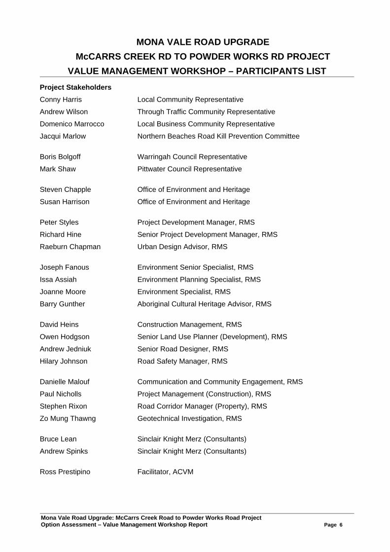
Appendix 1. List of Participants
Mona Vale Road Upgrade: McCarrs Creek Road to Powder Works Road Project Option Assessment – Value Management Workshop Report Page 6
MONA VALE ROAD UPGRADE McCARRS CREEK RD TO POWDER WORKS RD PROJECT
VALUE MANAGEMENT WORKSHOP – PARTICIPANTS LIST Project Stakeholders
Conny Harris Local Community Representative
Andrew Wilson Through Traffic Community Representative
Domenico Marrocco Local Business Community Representative
Jacqui Marlow Northern Beaches Road Kill Prevention Committee Boris Bolgoff Warringah Council Representative
Mark Shaw Pittwater Council Representative Steven Chapple Office of Environment and Heritage
Susan Harrison Office of Environment and Heritage Peter Styles Project Development Manager, RMS
Richard Hine Senior Project Development Manager, RMS
Raeburn Chapman Urban Design Advisor, RMS Joseph Fanous Environment Senior Specialist, RMS
Issa Assiah Environment Planning Specialist, RMS
Joanne Moore Environment Specialist, RMS
Barry Gunther Aboriginal Cultural Heritage Advisor, RMS David Heins Construction Management, RMS
Owen Hodgson Senior Land Use Planner (Development), RMS
Andrew Jedniuk Senior Road Designer, RMS
Hilary Johnson Road Safety Manager, RMS Danielle Malouf Communication and Community Engagement, RMS
Paul Nicholls Project Management (Construction), RMS
Stephen Rixon Road Corridor Manager (Property), RMS
Zo Mung Thawng Geotechnical Investigation, RMS Bruce Lean Sinclair Knight Merz (Consultants)
Andrew Spinks Sinclair Knight Merz (Consultants) Ross Prestipino Facilitator, ACVM
Mona Vale Road Upgrade: McCarrs Creek Road to Powder Works Road Project Option Assessment – Value Management Workshop Report Page 7
Appendix 2. Project Information and Analysis
Mona Vale Road Upgrade: McCarrs Creek Road to Powder Works Road Project Option Assessment – Value Management Workshop Report Page 8
Project Information and Analysis The information presented in this Appendix is a consolidation of the general outputs and perceptions by the workshop group as they shared information about the Mona Vale Upgrade – McCarrs Creek Road to Powder Works Road Project. This allowed the participants to later make comparisons of options based on the analysis of what they valued about the project area and what the project was required to achieve to be successful. Project Background and Overview Presentation In order to allow the participants to obtain a common understanding of the project and planning undertaken to date, Richard Hine, Senior Project Development Manager and Peter Styles, Project Development Manager, RMS, outlined the background and overview of the project and the studies undertaken to date as part of the options identification and investigation process. Their presentation material can be found in Appendix 4. However, a brief summary of information presented included:
• Project Update: − Mona Vale Road is a key element of the transport network serving the Northern Beaches and
the northern suburbs of Sydney. In 2009, the Roads and Maritime Services (RMS) prepared the Mona Vale to Macquarie Park Corridor Strategy which set out a 25 year framework for the management of the corridor
− One of the short term priorities identified in the Corridor Strategy was to address the current congestion and enhance the capacity and efficiency of the section of Mona Vale Road between Terrey Hills and Ingleside
− NSW MP Rob Stokes announced preliminary works would commence for the Mona Vale Road Upgrade between McCarrs Creek Road, Terrey Hills and Powder Works Road, Ingleside in May 2011
− Broad community consultation occurred from June to December 2011 identifying issues along the length. Feasible route options to avoid the sensitive Rocky Outcrop area were developed and released for public comment in October 2012
− It should be noted that options for the upgrade project only exist in the area of the Rocky Outcrop. For the remainder of the project, there is only one feasible corridor option available for the upgrade
− As part of the process to recommend a preferred alignment option, this Value Management (VM) workshop is being held in February 2013
− In late 2013, it is hoped that the Minister will announce the preferred alignment • The purpose of today’s VM workshop:
− It is to recommend a preferred option for the alignment of Mona Vale Road from the three feasible options available which allows the upgrade project to bypass the Rocky Outcrop. Today will only focus on the area of the upgrade project where there is three possible route options available
− Areas common to all, including the intersection treatments will not be examined in detail as these will be examined extensively in later stages of project development
• The objectives of the project are to: − Improve traffic capacity and efficiency for road users − Improve road safety by providing a four-lane divided carriageway − Provide for a minimum design speed of 80km/hr (posted speed 80km/hr) − Minimise impacts on National Parks, threatened species and heritage sites − Provide on-road cycle facilities and an off-road shared path, where appropriate − Make provision for buses at intersections
• The studies undertaken to date which will hopefully lead us to complete a strategic concept design for the project include: − Preliminary terrain survey − Preliminary geotechnical investigations − Property investigations − Traffic modeling and crash analysis
Mona Vale Road Upgrade: McCarrs Creek Road to Powder Works Road Project Option Assessment – Value Management Workshop Report Page 9
− Preliminary utilities investigations − Preliminary community consultation − Preliminary environmental investigations
• From the recent community consultation process, RMS has found that: − A total of 127 submissions were received providing 508 comments − All of the comments were placed into one of the eight issue categories being road user, roads
options, support, asset, built environment, natural environment, heritage and others • From an overall corridor perspective:
− Mona Vale Road is the northern segment of one of Sydney’s major north-south arterials - Metroad 3
− It is used as the primary westbound route for traffic from Narrabeen to Palm Beach in the north to travel to Sydney’s northern and western suburbs. Traffic traveling south to Sydney City generally follow Pittwater Road
− It is also used by local traffic connecting the suburbs of St Ives and Terrey Hills to Ingleside, Elanora Heights and Mona Vale
− Wakehurst Parkway relieves some traffic from Mona Vale Road • The traffic analysis indicates:
− There is peak commuter weekday traffic with recreational and tourism peaks on weekends − The existing road operates at Level Of Service (LOS) E during the peak periods while
approaching lengths of the road in our study area operate at LOS C − Heavy vehicles account for 9.7% of the daily traffic. Of that 9.7%, large articulated vehicles
accounted for 1.7% and small-medium rigid trucks accounted for 8% − The road also services the Forest Bus Service 196 & 197 Routes − Proposed arrangements include two new signalised intersections at Kimbirki Road and
Tumburra Street • In terms of road safety:
− This section of road is currently sign posted at 70km/hr − The proposed speed limit is 80 km/hr (design and posted speed limit) − The current single lane sections provide little opportunity for overtaking and the crash history
has been investigated as part of traffic studies − The most recent fatality occurred in January 2008 at the Tumburra Street intersection
• With regards to pedestrian and cycle facilities: − There are currently limited facilities for pedestrians and cyclists − The current designs include a 2m-2.5m wide shoulder marked as an on-road cycle way − Steep grades, terrain and environmental constraints make the provision of shared paths difficult − The strategy is to combine paths, recreation and relocate utilities into the same corridor away
from the road • With regards to utilities:
− Preliminary utility investigations have been completed. There are regionally significant utilities occurring along the route. Some lengths will also impact on Duffys Forest
− All three options will impact on utilities, though some are more significant than others − A preliminary strategy for up-front relocation of utilities has been prepared with the emphasis to
relocate them into the shared path corridor away from the road which will allow for safer ongoing operation, access and maintenance of the utilities
• With regards to the environmental approval process: − The approval process will be lengthy (ie. likely to be more than 18 months) − All efforts are being made to avoid and/or minimise the impact on the major environmental
constraints as well as the impacts to the National Parks − Encroachment into a National Park requires an Act of Parliament to acquire the land. There are
two National Parks adjacent to the project being Ku-ring-gai Chase National Park and Garigal National Park
− Currently, all options will require acquisition of some National Park land in order to achieve the project objectives. All are relatively similar and cumulatively the land required is in the order of 0.5ha
− Compensatory habitat is likely to be required and the ratio of this is yet to be determined
Mona Vale Road Upgrade: McCarrs Creek Road to Powder Works Road Project Option Assessment – Value Management Workshop Report Page 10
• With regards to environmental constraints: − A preliminary environmental investigations report, has been completed which includes
constraint maps, ecological investigations, Aboriginal heritage assessment, non-Aboriginal heritage assessment and a preliminary urban design report
• With regards to the Endangered Species and Ecological Communities: − Grevillea caleyi is an endangered species (under the Threatened Species Conservation Act
[TSC] & the Environment Protection and Biodiversity Conservation Act [EPBC Act]) − Microtis angusii (Angus’ Onion Orchid) is an endangered species (under the TSC & EPBC Act) − Within Duffy’s Forest there are endangered ecological communities (under the TSC Act)
• With regards to wildlife issues along the route: − There are road kill issues along the project’s length. Hotspots have been identified by the
Northern Beaches Roadkill Prevention Committee report − There is a need to make provisions for wildlife crossings on all options − Wildlife fencing and urban design impacts need to be considered − Measures need to be taken concerning impacts to termite mounds and their relationship with
the Rosenberg’s Goanna • With regards to Aboriginal heritage:
− The Rocky Outcrop and the surrounding area is of Aboriginal cultural significance − The alignments have designed to avoid impact on this site and so will any construction areas
and practices − No other sites have been identified within the study corridor
• With regards to non-Aboriginal heritage: − A number of non-Aboriginal heritage items exist within the study area. The most significant
being the Baha’i Temple and surrounds − The Baha’i temple and it’s curtilage may be listed in the future as a State significant item
• With regards to Urban Design and Future Developments: − A preliminary urban design investigation has been completed and clarifies the importance of
the undulating feel of the route, the fauna connectivity and the visually significant landscapes that the route presents
− There is a need to consider the impacts of the development of the Kimbriki Tip and the Ingleside development area
− Most of the adjoining land impacted by the project is government land but there will be some private acquisition required
− The project could be impacted by aboriginal land claims • With regards to the site topography:
− There are a number of key challenges, along the corridor including the steep grades as the road descends approximately 75m over a length of 1.5km from Tumbledown Dick Hill to Tumburra Street before climbing back 65m over 1km to the Baha’i Temple
− Over the 3.3km length, the topography represents a key challenge in terms of the management of stormwater, erosion and sediment control during the construction, operation and maintenance of the road upgrade
• With regards to constructability: − Preliminary geotechnical investigations have been completed and further mapping is underway.
However the investigations indicate that building the road will be a challenge − All options were considered possible, however one option was highlighted as a major risk − Key conclusions from the recent constructability review included
Access to do the work will be a challenge – base of walls, piling rigs, cranes Further geotechnical certainty is required – prior fill stability, risky terrain areas are evident There are space restrictions and worker safety issues – suitable and safe working areas
are needed Traffic switches, staging and night works need to be considered Utilities remain a relatively neutral impact between options Duration of constructing the different options vary depending on the alignment Site management areas were identified
Mona Vale Road Upgrade: McCarrs Creek Road to Powder Works Road Project Option Assessment – Value Management Workshop Report Page 11
The Problem Situation The workshop group shared with each other what was the “problem situation” to be considered as part of the upgrade. A number of the problems were highlighted in the Background Paper for the VM Workshop which had been distributed to participants prior to the workshop. The participants had the opportunity to seek clarification to those already identified and add others so that there was a common understanding of the problems from a range of perspectives. The “problem situation” included:
• There is traffic congestion during peak periods causing capacity and travel time problems • There are variable road conditions and speed limits between St Ives and Mona Vale • There is a lack of cyclist, recreational and pedestrian facilities (on and off road) connecting Terrey
Hills and Ingleside • The crash history along this length of road is related to the alignment, intersections and fauna
movement as well as limitations for vehicle breakdown due to the narrow shoulders • It is a road kill hotspot due to the lack of containment and connectivity between the National Parks
for fauna movement • The proximity of the upgrade to the Ku-ring-gai Chase and Garigal National Parks is an issue, as is
the impact to threatened species • There are significant heritage constraints within the corridor • There is a lack of public transport provisions along the project length • There are no local alternative routes (other than Mona Vale Road in this area)
Purpose of the Road and the Project The workshop group reflected on the purpose of the road and the purpose of the project. The workshop group concluded:
The purpose of Mona Vale Road (Its reason for being) The purpose of Mona Vale Road to provide a key link for communities on the Northern Beaches with the existing Northern Sydney Road Network
Project Purpose (What is the purpose of this project?) The purpose of this project is to improve the capacity, efficiency and safety for all road users in this single lane section of Mona Vale Road between Terrey Hills and Ingleside
It was noted by one of the community participants that although the purpose of this project and the VM workshop was to concentrate on this section of Mona Vale Road, some members of the local community were of the belief that the priority for upgrade should have been another section of the road closer to Mona Vale.
The Project Objectives The workshop group reflected on the project objectives (ie. what must the project achieve to be successful) that the team were working to. After clarification, the workshop group agreed to the project objectives outlined below.
Project Objectives (What must the project achieve to be successful?) To be successful the project should:
• Improve traffic capacity and efficiency for road users • Improve road safety by providing a four-lane divided carriageway • Provide for a sign posted speed of 80km/hr (with the aim of a design speed of 80km/hr) • Minimise impacts on National Parks, threatened species and heritage sites • Provide on-road cycle facilities and an off-road shared path, where appropriate • Make provision for buses at intersections
Mona Vale Road Upgrade: McCarrs Creek Road to Powder Works Road Project Option Assessment – Value Management Workshop Report Page 12
What Else is Important that the Project should Reflect? The workshop group shared from their various perspectives what else the project should reflect to be successful. To be successful it should also:
• Provide for future expansion and/or population and traffic growth • Integrate the location of utilities with the transport corridor • Provide connectivity through the National Park system • Be compatible with any future adjoining road upgrade of Mona Vale Road particularly to the east • Ensure the timing and flow of the upgrade is compatible with developing the intersection of Kimbriki
Road so they are considered together and there is no future rework required later • Maintain a sense of place by undertaking sensitive urban design and minimising visual impact in
upholding Aboriginal and non-Aboriginal heritage and cultural values • Consider grade separation at the intersections • Minimise the impact of construction on traffic, connectivity across the corridor and other ecological
activity Givens and Constraints we are working within The group reflected on the givens and constraints that the project was being planned within. These were identified in the VM Workshop Background Paper and were clarified, added to and amended where necessary by the workshop participants. They were agreed to by the group as outlined below.
Givens we are working within • From the preliminary work undertaken, only three route options are available as a means to bypass
the Rocky Outcrop • The Rocky Outcrop cannot be removed, harmed or placed at risk of damage • All options will require acquisition of some National Park lands • The project must preserve the quality of the diverse natural, built and community environments • Traffic will continue to grow commensurate with the regional population and economic growth • The project must accommodate for the future expansion of residential growth areas in Warriewood
and Ingleside as well as expansion of the Kimbriki Resource Recovery Centre • The aim is to provide a pathway (for pedestrian and recreational cyclist) where appropriate. It may
not meet “shared pathway” standards (ie. maximum grades, etc) • The project needs to consider enhanced public transport accessibility and efficiency along the
length of the upgrade • The upgrade will require a minimum of four lanes along the length including shoulders for safe
vehicle break down • A standard cross section will be used (2m-2.5m shoulders LHS, 3.5m lanes, 2.6m median with F-
type barrier) • The aim is for an 80 km/hr design speed without compromising safety in design objectives and a
90km/hr design speed will be adopted, where feasible. The posted speed will be 80 km/hr throughout
• The aim is to target a maximum grade of less than 10% for Mona vale Road, although this may not be achievable for all options
• The aim is to improve the efficiency for heavy vehicles and the reliability of travel times for other road users through the minimising of steep grades
Constraints we need to take into account
• Access and constructability is constrained by site topography, geology and the proximity to the National Parks
Mona Vale Road Upgrade: McCarrs Creek Road to Powder Works Road Project Option Assessment – Value Management Workshop Report Page 13
• Resident, commercial, tourist and recreational access will only be via key intersections along the length of the upgrade
• There is a need to cater for bush fire management and emergency services access • Excess material will need to be disposed of from the project area • Impacts on threatened ecological communities, TECs (Duffys Forest Endangered Ecological
Community), threatened species (Caley’s Grevillea and Angus’s Onion Orchid) and fauna connectivity (roadkill hotspots within the corridor) need to be minimised
• Impacts on National Park lands, and other landholdings including private property (ie. Kimbriki Tip) need to be considered (ie. water quality controls, access, amenity, etc)
• Implications for places and items of Aboriginal and non-Aboriginal heritage significance need to be considered
• There are geotechnical risks related to constructability (rock workability, slope stability, etc), costs, and worker safety
• There is a need to maintain two lanes on Mona Vale Road with adequate shoulders to ensure the road is capable of handling daily traffic demands and short term increased demand at times resulting from flooding closures of the Wakehurst Parkway
• Access to Kimbriki Tip, Tumburra Street, Addison Street, McCarrs Creek Road and Powder Works Road must be maintained throughout construction activities for any option
• Cyclists, pedestrians, horse riders and bushwalkers need to be catered for • Protecting, maintaining or relocating affected utilities need to be catered for • The project will need to be sympathetic to the surrounding environment through good urban design • Asset maintenance and network response needs to be considered • The challenge of drainage and water quality management within steep grades and narrow corridors
needs to be managed • The long term maintenance of water quality structures need to be considered (ie. access, etc) • Ensure that any Aboriginal Land Claim does not impact, delay or stop the project • There is a need to consider buffer widths between the project and any protected items • There is a need to minimise any “edge” effect on the adjoining bushland from the road use (such as
weed and debris management) Assessment Criteria Using the project objectives and other aspects considered important (of value) to the project stakeholders, some draft assessment criteria were proposed in the VM Workshop Background Paper to evaluate the technical/functional, natural and built environmental and socio-economic performance of the options to help the workshop group differentiate between them. It was noted that costs were not included as a criteria but would be added during the workshop process to assist in identifying which option provides the best “value for money”. As a result of the information shared in the workshop to date, the group reviewed the draft assessment criteria that could be used to qualitatively evaluate the various options to meet the needs previously discussed. These assessment criteria (in the three categories of technical/functional, natural and built environmental and socio-economic perspectives) would reflect the values which the group considered important that the project must reflect. The approach adopted was that for each of the draft assessment criteria identified, the group clarified what it meant, ensured it reflected the purpose and values that the project should achieve and that it would assist in differentiating between the various options. The group clarified, amended and added to the draft assessment criteria to reflect what was considered of value in the study area. The group discussed, amended and finally agreed to the assessment criteria below to be used to evaluate the options for the project within the three categories of technical/functional, natural and built environmental and socio-economic perspectives.
Mona Vale Road Upgrade: McCarrs Creek Road to Powder Works Road Project Option Assessment – Value Management Workshop Report Page 14
The assessment criteria accepted by the whole group to evaluate the options were: Technical/Functional Perspective:
A – Improve safety for end users B – Ease of investigation and construction, minimising worker risk and provide capacity for staging of works to minimise duration C – Minimise construction traffic and through traffic impacts D – Provide the best integration of public utilities with the transport solution E – Provide the best opportunity to accommodate public transport expansion into the future F – Provide the best ongoing operation and maintenance solution
Natural and Built Environment Perspective: A – Minimise impacts on TECs and threatened species B – Minimise impacts on the National Park (including acquisition) C – Provide opportunities for improved flora and fauna connectivity D – Minimise impacts on water quality
Socio-Economic Perspective: A – Minimise heritage/cultural impacts B – Minimise adverse impacts to the local amenity (access, noise, air quality, quality of life, etc except the connectivity extent) C – Minimise adverse impacts to views and fits best with the tourist route aesthetics D – Minimise adverse impacts to the adjacent community and businesses E – Provide the best opportunity for recreational access between communities and National Parks (ie. connectivity extent)
It was noted during the discussion that:
• Most of the assessment criteria had a “during construction” and “during operation” component. Although “during construction” was seen as short term and “during operation” as longer term, it was felt that each needed to be considered during the paired comparison of assessment criteria and later evaluation of the options
• The assessment criteria “Minimise impacts on TECs and threatened species” and “Minimise impacts on the National Park (including acquisition)” needed to be seen in the light of minimising the footprint of the project both during construction and operation and needed to be considered accordingly
• Although important to be achieved by the project, assessment criteria considered that were unlikely to assist in differentiating between the options included: − Improve capacity − Improve travel times − Allow better intersection design and provides safest access
Weighting of Assessment Criteria Relative weightings for the assessment criteria within each perspective were undertaken qualitatively by the whole group using a paired comparison technique. It should be noted that the paired comparison process resulted in some criteria receiving a score of zero. This should be interpreted as, the group believed the evaluation and recommendation of the preferred option would not rely on the performance of the option against this criteria even though the issue is important and requires careful consideration during the next stage of the project development.

Mona Vale Road Upgrade: McCarrs Creek Road to Powder Works Road Project Option Assessment – Value Management Workshop Report Page 15
The discussion in undertaking the paired comparison process was extensive and allowed the group to understand and appreciate the various perspectives represented within the group. The final weightings were reached on a consensus basis. The group’s workings and their weightings of the assessment criteria for each perspective are shown below. From a Technical/Functional Perspective
No Assessment Raw Score Relative Weightings A. Improve safety for end users 5 33% B. Ease of investigation and construction, minimising worker
risk and provide capacity for staging of works to minimise duration
3.5 23%
C. Minimise construction traffic and through traffic impacts 1 7% D. Provide the best integration of public utilities with the
transport solution - 0%
E. Provide the best opportunity to accommodate public transport expansion into the future 2 13%
F. Provide the best ongoing operation and maintenance solution 3.5 23%
Total 15 99% Scoring Matrix
The workings for the relative assessment are shown below. B C D E F
A A A A A A B B B B B/F C C E F D E F E F F
Summary The weighting of the assessment criteria from a Technical/Functional Perspective using the paired comparison approach indicated that the “Improve safety for end users” was the most important criteria followed by the “Ease of investigation and construction, minimising worker risk and provide capacity for staging of works to minimise duration” and “Provide the best ongoing operation and maintenance solution” then followed by “Provide the best opportunity to accommodate public transport expansion into the future” and then “Minimise construction traffic and through traffic impacts” on the next level of importance. “Provide the best integration of public utilities with the transport solution” although important was not considered as important as the other criteria when compared in pairs and scored zero.
Mona Vale Road Upgrade: McCarrs Creek Road to Powder Works Road Project Option Assessment – Value Management Workshop Report Page 16
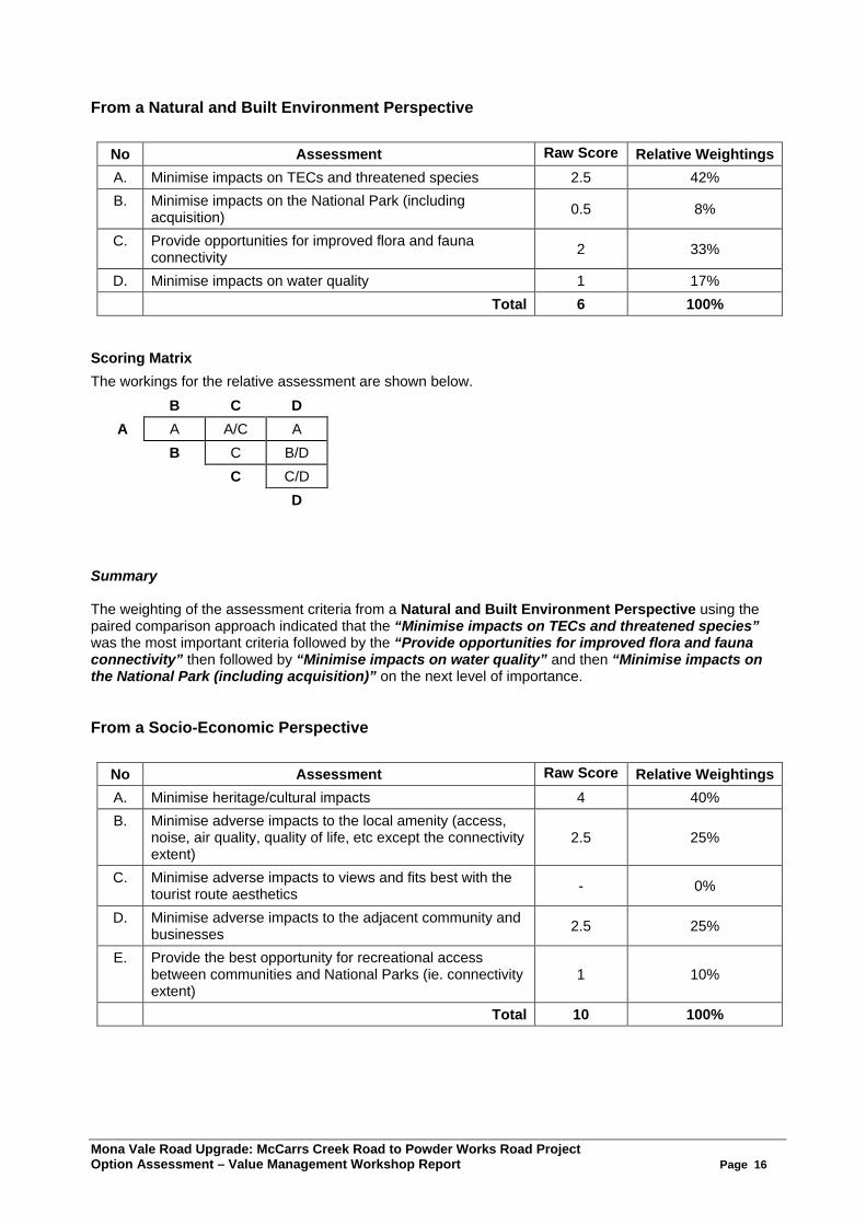
From a Natural and Built Environment Perspective
No Assessment Raw Score Relative Weightings A. Minimise impacts on TECs and threatened species 2.5 42% B. Minimise impacts on the National Park (including
acquisition) 0.5 8%
C. Provide opportunities for improved flora and fauna connectivity 2 33%
D. Minimise impacts on water quality 1 17% Total 6 100%
Scoring Matrix
The workings for the relative assessment are shown below. B C D
A A A/C A B C B/D C C/D D
Summary The weighting of the assessment criteria from a Natural and Built Environment Perspective using the paired comparison approach indicated that the “Minimise impacts on TECs and threatened species” was the most important criteria followed by the “Provide opportunities for improved flora and fauna connectivity” then followed by “Minimise impacts on water quality” and then “Minimise impacts on the National Park (including acquisition)” on the next level of importance. From a Socio-Economic Perspective
No Assessment Raw Score Relative Weightings A. Minimise heritage/cultural impacts 4 40% B. Minimise adverse impacts to the local amenity (access,
noise, air quality, quality of life, etc except the connectivity extent)
2.5 25%
C. Minimise adverse impacts to views and fits best with the tourist route aesthetics - 0%
D. Minimise adverse impacts to the adjacent community and businesses 2.5 25%
E. Provide the best opportunity for recreational access between communities and National Parks (ie. connectivity extent)
1 10%
Total 10 100%

Mona Vale Road Upgrade: McCarrs Creek Road to Powder Works Road Project Option Assessment – Value Management Workshop Report Page 17
Scoring Matrix
The workings for the relative assessment are shown below. B C D E
A A A A A B B B/D B C D E D D E
Summary The weighting of the assessment criteria from a Socio-Economic Perspective using the paired comparison approach indicated that the “Minimise heritage/cultural impacts” was the most important criteria followed by the “Minimise adverse impacts to the local amenity (access, noise, air quality, quality of life, etc except the connectivity extent)” and “Minimise adverse impacts to the adjacent community and businesses” then followed by “Provide the best opportunity for recreational access between communities and National Parks (ie. connectivity extent)” on the next level of importance. “Minimise adverse impacts to views and fits best with the tourist route aesthetics” although important was not considered as important as the other criteria when compared in pairs and scored zero. A summary of the weightings of the assessment criteria within the various themes as determined by the group appears below.
Assessment Criteria
Technical/Functional Natural & Built Environment Socio-Economic
Criteria Wt Criteria Wt Criteria Wt Improve safety for end users 33%
Minimise impacts on TECs and threatened species
42% Minimise heritage/ cultural impacts 40%
Ease of investigation and construction, minimising worker risk and provide capacity for staging of works to minimise duration
23%
Minimise impacts on the National Park (including acquisition) 8%
Minimise adverse impacts to the local amenity (access, noise, air quality, quality of life, etc except the connectivity extent)
25%
Minimise construction traffic and through traffic impacts
7% Provide opportunities for improved flora and fauna connectivity
33% Minimise adverse impacts to views and fits best with the tourist route aesthetics
0%
Provide the best integration of public utilities with the transport solution
0% Minimise impacts on water quality 17%
Minimise adverse impacts to the adjacent community and businesses
25%
Provide the best opportunity to accommodate public transport expansion into the future
13%
Provide the best opportunity for recreational access between communities and National Parks (ie. connectivity extent)
10%
Provide the best ongoing operation and maintenance solution
23%
These weighted assessment criteria would later be used to evaluate the options for the project. Having built a foundation and common understanding of the issues, what is important, the givens and the assessment criteria for option evaluation, the group was now in a position to broadly review the various options for the project.
Mona Vale Road Upgrade: McCarrs Creek Road to Powder Works Road Project Option Assessment – Value Management Workshop Report Page 18
Appendix 3. Option Review and Recommendation
Mona Vale Road Upgrade: McCarrs Creek Road to Powder Works Road Project Option Assessment – Value Management Workshop Report Page 19
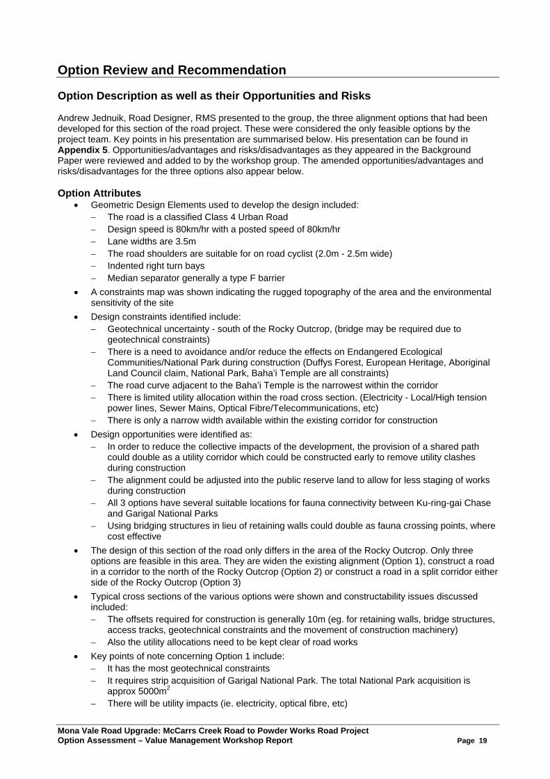
Option Review and Recommendation Option Description as well as their Opportunities and Risks Andrew Jednuik, Road Designer, RMS presented to the group, the three alignment options that had been developed for this section of the road project. These were considered the only feasible options by the project team. Key points in his presentation are summarised below. His presentation can be found in Appendix 5. Opportunities/advantages and risks/disadvantages as they appeared in the Background Paper were reviewed and added to by the workshop group. The amended opportunities/advantages and risks/disadvantages for the three options also appear below. Option Attributes
• Geometric Design Elements used to develop the design included: − The road is a classified Class 4 Urban Road − Design speed is 80km/hr with a posted speed of 80km/hr − Lane widths are 3.5m − The road shoulders are suitable for on road cyclist (2.0m - 2.5m wide) − Indented right turn bays − Median separator generally a type F barrier
• A constraints map was shown indicating the rugged topography of the area and the environmental sensitivity of the site
• Design constraints identified include: − Geotechnical uncertainty - south of the Rocky Outcrop, (bridge may be required due to
geotechnical constraints) − There is a need to avoidance and/or reduce the effects on Endangered Ecological
Communities/National Park during construction (Duffys Forest, European Heritage, Aboriginal Land Council claim, National Park, Baha’i Temple are all constraints)
− The road curve adjacent to the Baha’i Temple is the narrowest within the corridor − There is limited utility allocation within the road cross section. (Electricity - Local/High tension
power lines, Sewer Mains, Optical Fibre/Telecommunications, etc) − There is only a narrow width available within the existing corridor for construction
• Design opportunities were identified as: − In order to reduce the collective impacts of the development, the provision of a shared path
could double as a utility corridor which could be constructed early to remove utility clashes during construction
− The alignment could be adjusted into the public reserve land to allow for less staging of works during construction
− All 3 options have several suitable locations for fauna connectivity between Ku-ring-gai Chase and Garigal National Parks
− Using bridging structures in lieu of retaining walls could double as fauna crossing points, where cost effective
• The design of this section of the road only differs in the area of the Rocky Outcrop. Only three options are feasible in this area. They are widen the existing alignment (Option 1), construct a road in a corridor to the north of the Rocky Outcrop (Option 2) or construct a road in a split corridor either side of the Rocky Outcrop (Option 3)
• Typical cross sections of the various options were shown and constructability issues discussed included: − The offsets required for construction is generally 10m (eg. for retaining walls, bridge structures,
access tracks, geotechnical constraints and the movement of construction machinery) − Also the utility allocations need to be kept clear of road works
• Key points of note concerning Option 1 include: − It has the most geotechnical constraints − It requires strip acquisition of Garigal National Park. The total National Park acquisition is
approx 5000m2 − There will be utility impacts (ie. electricity, optical fibre, etc)
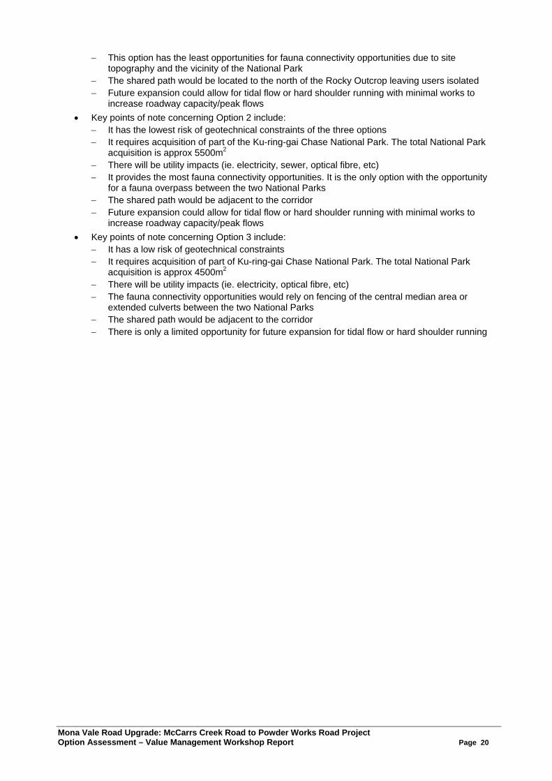
Mona Vale Road Upgrade: McCarrs Creek Road to Powder Works Road Project Option Assessment – Value Management Workshop Report Page 20
− This option has the least opportunities for fauna connectivity opportunities due to site topography and the vicinity of the National Park
− The shared path would be located to the north of the Rocky Outcrop leaving users isolated − Future expansion could allow for tidal flow or hard shoulder running with minimal works to
increase roadway capacity/peak flows • Key points of note concerning Option 2 include:
− It has the lowest risk of geotechnical constraints of the three options − It requires acquisition of part of the Ku-ring-gai Chase National Park. The total National Park
acquisition is approx 5500m2 − There will be utility impacts (ie. electricity, sewer, optical fibre, etc) − It provides the most fauna connectivity opportunities. It is the only option with the opportunity
for a fauna overpass between the two National Parks − The shared path would be adjacent to the corridor − Future expansion could allow for tidal flow or hard shoulder running with minimal works to
increase roadway capacity/peak flows • Key points of note concerning Option 3 include:
− It has a low risk of geotechnical constraints − It requires acquisition of part of Ku-ring-gai Chase National Park. The total National Park
acquisition is approx 4500m2 − There will be utility impacts (ie. electricity, optical fibre, etc) − The fauna connectivity opportunities would rely on fencing of the central median area or
extended culverts between the two National Parks − The shared path would be adjacent to the corridor − There is only a limited opportunity for future expansion for tidal flow or hard shoulder running
Mona Vale Road Upgrade: McCarrs Creek Road to Powder Works Road Project Option Assessment – Value Management Workshop Report Page 21
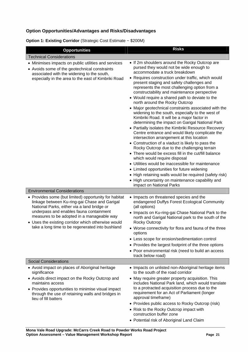
Option Opportunities/Advantages and Risks/Disadvantages Option 1: Existing Corridor (Strategic Cost Estimate ~ $200M)
Opportunities Risks
Technical Considerations • Minimises impacts on public utilities and services • Avoids some of the geotechnical constraints
associated with the widening to the south, especially in the area to the east of Kimbriki Road
• If 2m shoulders around the Rocky Outcrop are pursed they would not be wide enough to accommodate a truck breakdown
• Requires construction under traffic, which would present staging and safety challenges and represents the most challenging option from a constructability and maintenance perspective
• Would require a shared path to deviate to the north around the Rocky Outcrop
• Major geotechnical constraints associated with the widening to the south, especially to the west of Kimbriki Road. It will be a major factor in determining the impact on Garigal National Park
• Partially isolates the Kimbriki Resource Recovery Centre entrance and would likely complicate the intersection arrangement at this location
• Construction of a viaduct is likely to pass the Rocky Outcrop due to the challenging terrain
• There would be excess fill in the cut/fill balance which would require disposal
• Utilities would be inaccessible for maintenance • Limited opportunities for future widening • High retaining walls would be required (safety risk) • High uncertainty on maintenance capability and
impact on National Parks Environmental Considerations • Provides some (but limited) opportunity for habitat
linkage between Ku-ring-gai Chase and Garigal National Parks, either via a land bridge or underpass and enables fauna containment measures to be adopted in a manageable way
• Uses the existing corridor which otherwise would take a long time to be regenerated into bushland
• Impacts on threatened species and the endangered Duffys Forest Ecological Community (all options)
• Impacts on Ku-ring-gai Chase National Park to the north and Garigal National park to the south of the Rocky Outcrop
• Worse connectivity for flora and fauna of the three options
• Less scope for erosion/sedimentation control • Provides the largest footprint of the three options • Poor environmental risk (need to build an access
track below road) Social Considerations • Avoid impact on places of Aboriginal heritage
significance • Avoids direct impact on the Rocky Outcrop and
maintains access • Provides opportunities to minimise visual impact
through the use of retaining walls and bridges in lieu of fill batters
• Impacts on unlisted non-Aboriginal heritage items to the south of the road corridor
• May require greater property acquisition. This includes National Park land, which would translate to a protracted acquisition process due to the requirement for an Act of Parliament (longer approval timeframe)
• Provides public access to Rocky Outcrop (risk) • Risk to the Rocky Outcrop impact with
construction buffer zone • Potential risk of Aboriginal Land Claim
Mona Vale Road Upgrade: McCarrs Creek Road to Powder Works Road Project Option Assessment – Value Management Workshop Report Page 22
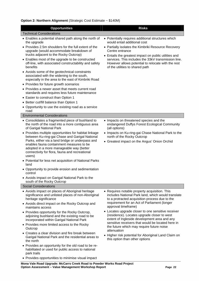
Option 2: Northern Alignment (Strategic Cost Estimate ~ $140M)
Opportunities Risks Technical Considerations • Enables a potential shared path along the north of
the upgrade • Provides 2.5m shoulders for the full extent of the
upgrade (would accommodate breakdown of trucks adjacent to the Rocky Outcrop)
• Enables most of the upgrade to be constructed off-line, with associated constructability and safety benefits
• Avoids some of the geotechnical constraints associated with the widening to the south, especially in the area to the east of Kimbriki Road
• Provides for future growth scenarios • Provides a newer asset that meets current road
standards and requires less future maintenance • Easier to construct than Option 1 • Better cut/fill balance than Option 1 • Opportunity to use the existing road as a service
road
• Potentially requires additional structures which would entail additional cost
• Partially isolates the Kimbriki Resource Recovery Centre entrance
• Entails the greatest impact on public utilities and services. This includes the 33kV transmission line. However allows potential to relocate with the rest of the utilities to shared path
Environmental Considerations • Consolidates a fragmented piece of bushland to
the north of the road into a more contiguous area of Garigal National Park
• Provides multiple opportunities for habitat linkage between Ku-ring-gai Chase and Garigal National Parks, either via a land bridge or underpass and enables fauna containment measures to be adopted in a more manageable way (better connectivity for flora, fauna and recreational users)
• Potential for less net acquisition of National Parks land
• Opportunity to provide erosion and sedimentation control
• Avoids impact on Garigal National Park to the south of the Rocky Outcrop
• Impacts on threatened species and the endangered Duffys Forest Ecological Community (all options)
• Impacts on Ku-ring-gai Chase National Park to the north of the Rocky Outcrop
• Greatest impact on the Angus’ Onion Orchid
Social Considerations • Avoids impact on places of Aboriginal heritage
significance and unlisted places of non-Aboriginal heritage significance
• Avoids direct impact on the Rocky Outcrop and maintains access
• Provides opportunity for the Rocky Outcrop, adjoining bushland and the existing road to be incorporated within Garigal National Park
• Provides more limited access to the Rocky Outcrop
• Creates a clear division and fire break between Garigal National Park and the residential areas to the north
• Provides an opportunity for the old road to be re-habilitated or used for public access to national park trails
• Provides opportunities to minimise visual impact
• Requires notable property acquisition. This includes National Park land, which would translate to a protracted acquisition process due to the requirement for an Act of Parliament (longer approval timeframe)
• Locates upgrade closer to one sensitive receiver (residence). Locates upgrade closer to west extent of Ingleside development area and any sensitive receivers that would be located here in the future which may require future noise attenuation
• Higher risk potential for Aboriginal Land Claim on this option than other options
Mona Vale Road Upgrade: McCarrs Creek Road to Powder Works Road Project Option Assessment – Value Management Workshop Report Page 23
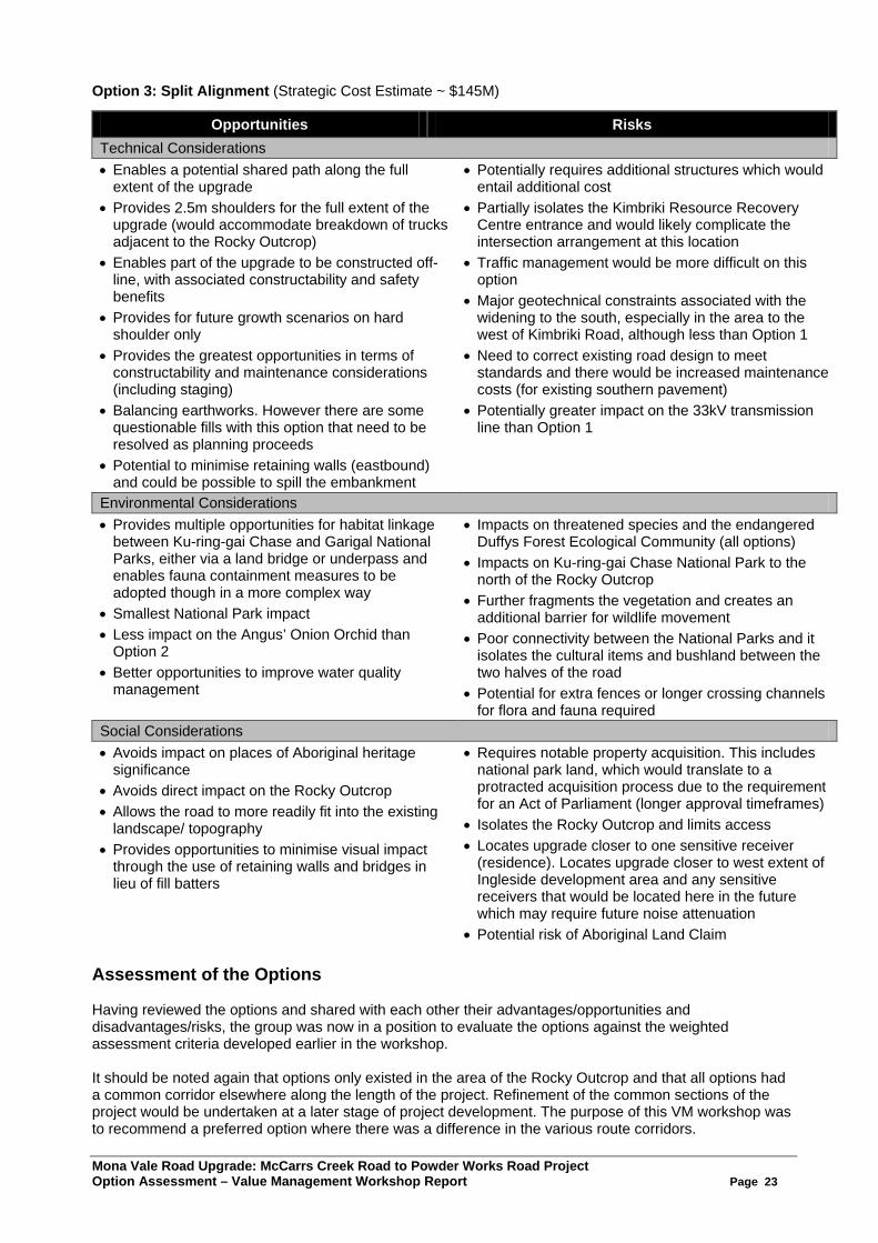
Option 3: Split Alignment (Strategic Cost Estimate ~ $145M)
Opportunities Risks Technical Considerations • Enables a potential shared path along the full
extent of the upgrade • Provides 2.5m shoulders for the full extent of the
upgrade (would accommodate breakdown of trucks adjacent to the Rocky Outcrop)
• Enables part of the upgrade to be constructed off-line, with associated constructability and safety benefits
• Provides for future growth scenarios on hard shoulder only
• Provides the greatest opportunities in terms of constructability and maintenance considerations (including staging)
• Balancing earthworks. However there are some questionable fills with this option that need to be resolved as planning proceeds
• Potential to minimise retaining walls (eastbound) and could be possible to spill the embankment
• Potentially requires additional structures which would entail additional cost
• Partially isolates the Kimbriki Resource Recovery Centre entrance and would likely complicate the intersection arrangement at this location
• Traffic management would be more difficult on this option
• Major geotechnical constraints associated with the widening to the south, especially in the area to the west of Kimbriki Road, although less than Option 1
• Need to correct existing road design to meet standards and there would be increased maintenance costs (for existing southern pavement)
• Potentially greater impact on the 33kV transmission line than Option 1
Environmental Considerations • Provides multiple opportunities for habitat linkage
between Ku-ring-gai Chase and Garigal National Parks, either via a land bridge or underpass and enables fauna containment measures to be adopted though in a more complex way
• Smallest National Park impact • Less impact on the Angus’ Onion Orchid than
Option 2 • Better opportunities to improve water quality
management
• Impacts on threatened species and the endangered Duffys Forest Ecological Community (all options)
• Impacts on Ku-ring-gai Chase National Park to the north of the Rocky Outcrop
• Further fragments the vegetation and creates an additional barrier for wildlife movement
• Poor connectivity between the National Parks and it isolates the cultural items and bushland between the two halves of the road
• Potential for extra fences or longer crossing channels for flora and fauna required
Social Considerations • Avoids impact on places of Aboriginal heritage
significance • Avoids direct impact on the Rocky Outcrop • Allows the road to more readily fit into the existing
landscape/ topography • Provides opportunities to minimise visual impact
through the use of retaining walls and bridges in lieu of fill batters
• Requires notable property acquisition. This includes national park land, which would translate to a protracted acquisition process due to the requirement for an Act of Parliament (longer approval timeframes)
• Isolates the Rocky Outcrop and limits access • Locates upgrade closer to one sensitive receiver
(residence). Locates upgrade closer to west extent of Ingleside development area and any sensitive receivers that would be located here in the future which may require future noise attenuation
• Potential risk of Aboriginal Land Claim Assessment of the Options Having reviewed the options and shared with each other their advantages/opportunities and disadvantages/risks, the group was now in a position to evaluate the options against the weighted assessment criteria developed earlier in the workshop. It should be noted again that options only existed in the area of the Rocky Outcrop and that all options had a common corridor elsewhere along the length of the project. Refinement of the common sections of the project would be undertaken at a later stage of project development. The purpose of this VM workshop was to recommend a preferred option where there was a difference in the various route corridors.
Mona Vale Road Upgrade: McCarrs Creek Road to Powder Works Road Project Option Assessment – Value Management Workshop Report Page 24
The group (in three focus groups) evaluated the options using the assessment criteria for each of the key perspectives being Technical/Functional; Natural and Built Environment and Socio-Economic. For instance, one focus group assessed the options against the technical/functional perspective, whilst a second focus group assessed the options against the natural and built environment perspective, and so on. It should be noted that each focus group was (as much as possible) a representative cross section of the workshop participants (ie. a mix of community, council, government agencies and RMS, etc). The options were assessed relatively and on a qualitative basis of how each option met each criteria on a scale of 1 through to 5 or using the qualitative terms Excellent (E), Very Good (VG), Good (G), Fair (F) or Poor (P). The best performing option against each assessment criteria was given the highest rating and the other options given a rating based on their performance against that criteria relative to the best performing option. Where information on a particular issue was incomplete, the group used the “collective wisdom” of the participants undertaking the evaluation to determine the relativity of the options against the criteria in question. The group assessed the options against each criteria “on balance” of the considerations of the various points earlier articulated for each criteria. Once the qualitative evaluation was completed, the evaluation was scored using the weightings of the criteria and establishing a relative overall ranking for each option in each category/perspective. Each focus group discussed their findings and recorded their observations and conclusions as a result of their deliberations. The findings of each focus group were presented to the whole group for discussion, amendment (if necessary) and finally endorsement (if appropriate) as to an agreed assessment to assist the group move forward. Their findings as presented (together with amendments) and agreed by the whole group are listed below.
Mona Vale Road Upgrade: McCarrs Creek Road to Powder Works Road Project Option Assessment – Value Management Workshop Report Page 25
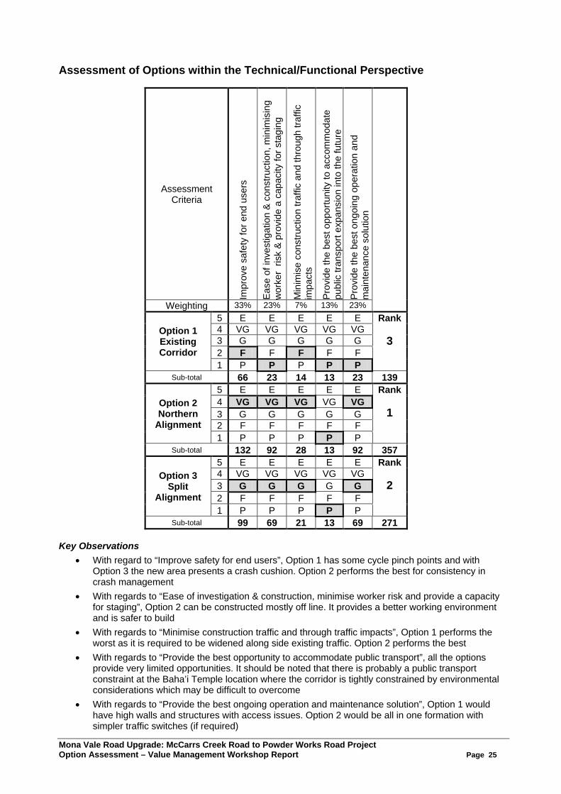
Assessment of Options within the Technical/Functional Perspective
Assessment Criteria
Impr
ove
safe
ty fo
r end
use
rs
Ease
of i
nves
tigat
ion
& co
nstru
ctio
n, m
inim
isin
g w
orke
r ris
k &
prov
ide
a ca
paci
ty fo
r sta
ging
Min
imis
e co
nstru
ctio
n tra
ffic
and
thro
ugh
traffi
c im
pact
s
Prov
ide
the
best
opp
ortu
nity
to a
ccom
mod
ate
publ
ic tr
ansp
ort e
xpan
sion
into
the
futu
re
Prov
ide
the
best
ong
oing
ope
ratio
n an
d m
aint
enan
ce s
olut
ion
Weighting 33% 23% 7% 13% 23%
Option 1 Existing Corridor
5 E E E E E Rank
3 4 VG VG VG VG VG 3 G G G G G 2 F F F F F 1 P P P P P
Sub-total 66 23 14 13 23 139
Option 2 Northern
Alignment
5 E E E E E Rank
1 4 VG VG VG VG VG 3 G G G G G 2 F F F F F 1 P P P P P
Sub-total 132 92 28 13 92 357
Option 3 Split
Alignment
5 E E E E E Rank
2 4 VG VG VG VG VG 3 G G G G G 2 F F F F F 1 P P P P P
Sub-total 99 69 21 13 69 271 Key Observations
• With regard to “Improve safety for end users”, Option 1 has some cycle pinch points and with Option 3 the new area presents a crash cushion. Option 2 performs the best for consistency in crash management
• With regards to “Ease of investigation & construction, minimise worker risk and provide a capacity for staging”, Option 2 can be constructed mostly off line. It provides a better working environment and is safer to build
• With regards to “Minimise construction traffic and through traffic impacts”, Option 1 performs the worst as it is required to be widened along side existing traffic. Option 2 performs the best
• With regards to “Provide the best opportunity to accommodate public transport”, all the options provide very limited opportunities. It should be noted that there is probably a public transport constraint at the Baha’i Temple location where the corridor is tightly constrained by environmental considerations which may be difficult to overcome
• With regards to “Provide the best ongoing operation and maintenance solution”, Option 1 would have high walls and structures with access issues. Option 2 would be all in one formation with simpler traffic switches (if required)

Mona Vale Road Upgrade: McCarrs Creek Road to Powder Works Road Project Option Assessment – Value Management Workshop Report Page 26
Assessment of Options within the Natural & Built Environment Perspective
Assessment Criteria
Min
imis
e im
pact
s on
TEC
s &
thre
aten
ed s
peci
es
Min
imis
e im
pact
s on
the
Nat
iona
l Par
ks
Prov
ide
oppo
rtuni
ties
for i
mpr
oved
flor
a &
faun
a co
nnec
tivity
Min
imis
e im
pact
s on
wat
er q
ualit
y
Weighting 42% 8% 33% 17%
Option 1 Existing Corridor
5 E E E E Rank
3 4 VG VG VG VG 3 G G G G 2 F F F F 1 P P P P
Sub-total 126 8 33 17 184
Option 2 Northern
Alignment
5 E E E E Rank
1 4 VG VG VG VG 3 G G G G 2 F F F F 1 P P P P
Sub-total 84 24 132 51 291
Option 3 Split
Alignment
5 E E E E Rank
2 4 VG VG VG VG 3 G G G G 2 F F F F 1 P P P P
Sub-total 84 16 66 34 200
Key Observations • With regards to “Minimise impacts on TECs and threatened species” (particularly the Angus’ Onion
Orchid), there appears not much difference between Options 2 and 3. However Option 1 has least impact
• With regards to “Minimise impacts on the National Parks”, Option 1 would require access tracks during construction which has the most impact and is also the most underestimated in terms of land take. Option 2 has the least impact in terms of land acquisition. However, all options will impact on National Parks
• With regards to “Provide opportunities for improved flora and fauna connectivity”, Option 2 provides a greater opportunity than the other options (eg. for overpass as against an underpass. Underpasses are considered inferior to overpasses). Option 1 appears to be the worst because constructability of a fauna structure is not feasible. Option 3 will need to use culverts for connectivity and will isolate flora and fauna populations
• With regards to “Minimise impacts on water quality”, Option 2 appears the best because it has more room to provide stormwater management measures in the footprint. Option 1 is the worst because there is no room for detention basins therefore the water runoff will be uncontrolled
• It was noted by the focus group that an opportunity existed in all options to locate utilities under the road shoulder in order to allow the shared path not to impact on adjoining bushland and allow greater revegetation
Mona Vale Road Upgrade: McCarrs Creek Road to Powder Works Road Project Option Assessment – Value Management Workshop Report Page 27
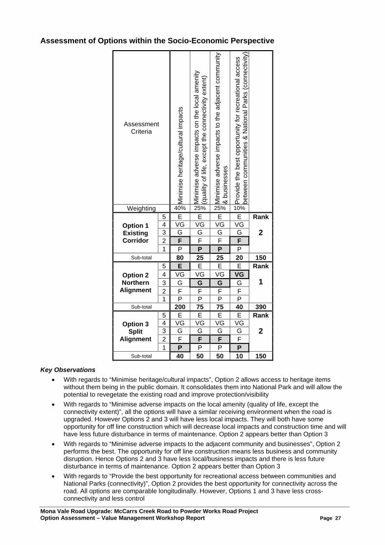
Assessment of Options within the Socio-Economic Perspective
Assessment Criteria
Min
imis
e he
ritag
e/cu
ltura
l im
pact
s
Min
imis
e ad
vers
e im
pact
s on
the
loca
l am
enity
(q
ualit
y of
life
, exc
ept t
he c
onne
ctiv
ity e
xten
t)
Min
imis
e ad
vers
e im
pact
s to
the
adja
cent
com
mun
ity
& bu
sine
sses
Prov
ide
the
best
opp
ortu
nity
for r
ecre
atio
nal a
cces
s be
twee
n co
mm
uniti
es &
Nat
iona
l Par
ks (c
onne
ctiv
ity)
Weighting 40% 25% 25% 10%
Option 1 Existing Corridor
5 E E E E Rank
2 4 VG VG VG VG 3 G G G G 2 F F F F 1 P P P P
Sub-total 80 25 25 20 150
Option 2 Northern
Alignment
5 E E E E Rank
1 4 VG VG VG VG 3 G G G G 2 F F F F 1 P P P P
Sub-total 200 75 75 40 390
Option 3 Split
Alignment
5 E E E E Rank
2 4 VG VG VG VG 3 G G G G 2 F F F F 1 P P P P
Sub-total 40 50 50 10 150 Key Observations
• With regards to “Minimise heritage/cultural impacts”, Option 2 allows access to heritage items without them being in the public domain. It consolidates them into National Park and will allow the potential to revegetate the existing road and improve protection/visibility
• With regards to “Minimise adverse impacts on the local amenity (quality of life, except the connectivity extent)”, all the options will have a similar receiving environment when the road is upgraded. However Options 2 and 3 will have less local impacts. They will both have some opportunity for off line construction which will decrease local impacts and construction time and will have less future disturbance in terms of maintenance. Option 2 appears better than Option 3
• With regards to “Minimise adverse impacts to the adjacent community and businesses”, Option 2 performs the best. The opportunity for off line construction means less business and community disruption. Hence Options 2 and 3 have less local/business impacts and there is less future disturbance in terms of maintenance. Option 2 appears better than Option 3
• With regards to “Provide the best opportunity for recreational access between communities and National Parks (connectivity)”, Option 2 provides the best opportunity for connectivity across the road. All options are comparable longitudinally. However, Options 1 and 3 have less cross-connectivity and less control
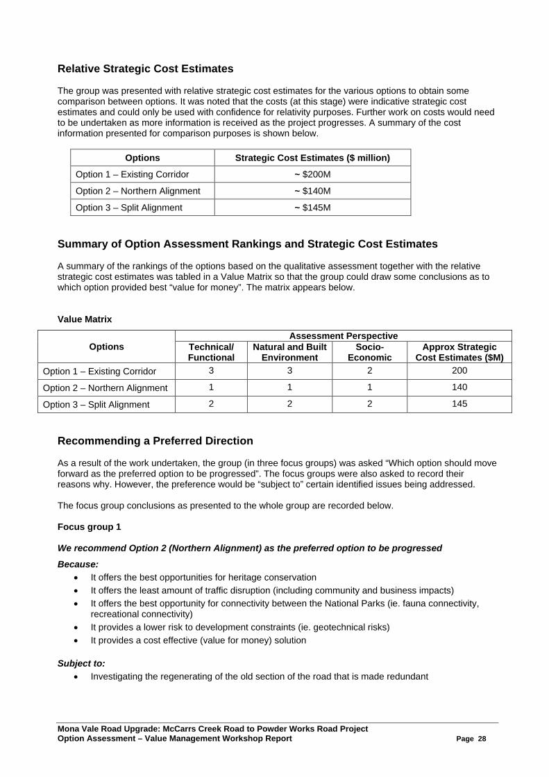
Mona Vale Road Upgrade: McCarrs Creek Road to Powder Works Road Project Option Assessment – Value Management Workshop Report Page 28
Relative Strategic Cost Estimates The group was presented with relative strategic cost estimates for the various options to obtain some comparison between options. It was noted that the costs (at this stage) were indicative strategic cost estimates and could only be used with confidence for relativity purposes. Further work on costs would need to be undertaken as more information is received as the project progresses. A summary of the cost information presented for comparison purposes is shown below.
Options Strategic Cost Estimates ($ million)
Option 1 – Existing Corridor ~ $200M
Option 2 – Northern Alignment ~ $140M
Option 3 – Split Alignment ~ $145M Summary of Option Assessment Rankings and Strategic Cost Estimates A summary of the rankings of the options based on the qualitative assessment together with the relative strategic cost estimates was tabled in a Value Matrix so that the group could draw some conclusions as to which option provided best “value for money”. The matrix appears below. Value Matrix
Options Assessment Perspective
Technical/ Functional
Natural and Built Environment
Socio-Economic
Approx Strategic Cost Estimates ($M)
Option 1 – Existing Corridor 3 3 2 200
Option 2 – Northern Alignment 1 1 1 140
Option 3 – Split Alignment 2 2 2 145 Recommending a Preferred Direction As a result of the work undertaken, the group (in three focus groups) was asked “Which option should move forward as the preferred option to be progressed”. The focus groups were also asked to record their reasons why. However, the preference would be “subject to” certain identified issues being addressed. The focus group conclusions as presented to the whole group are recorded below. Focus group 1 We recommend Option 2 (Northern Alignment) as the preferred option to be progressed
Because: • It offers the best opportunities for heritage conservation • It offers the least amount of traffic disruption (including community and business impacts) • It offers the best opportunity for connectivity between the National Parks (ie. fauna connectivity,
recreational connectivity) • It provides a lower risk to development constraints (ie. geotechnical risks) • It provides a cost effective (value for money) solution
Subject to:
• Investigating the regenerating of the old section of the road that is made redundant
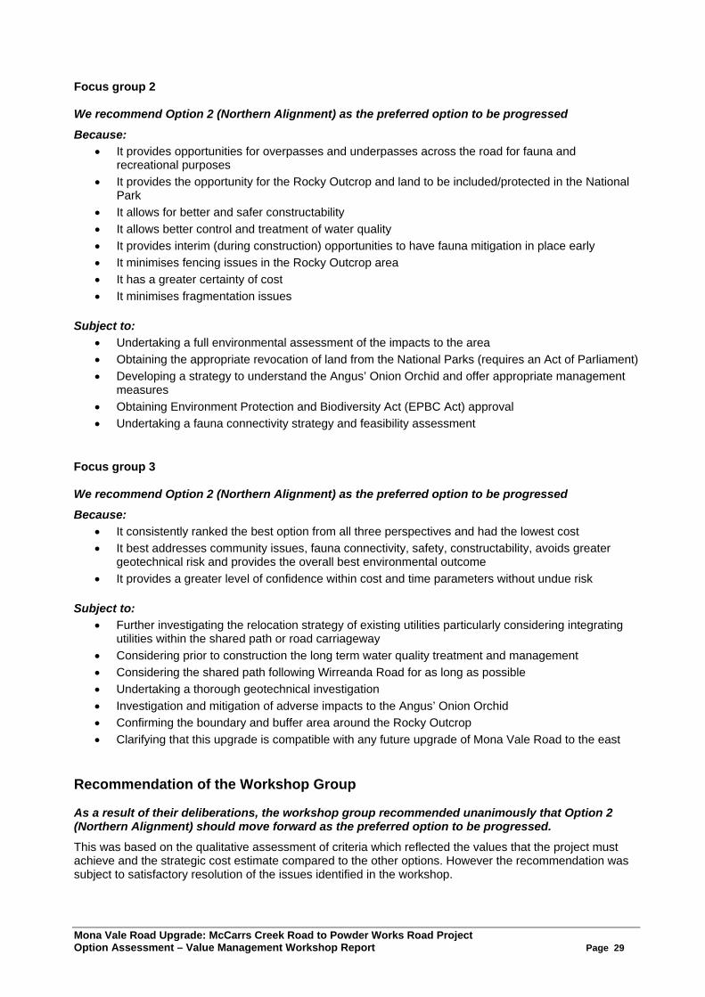
Mona Vale Road Upgrade: McCarrs Creek Road to Powder Works Road Project Option Assessment – Value Management Workshop Report Page 29
Focus group 2 We recommend Option 2 (Northern Alignment) as the preferred option to be progressed
Because: • It provides opportunities for overpasses and underpasses across the road for fauna and
recreational purposes • It provides the opportunity for the Rocky Outcrop and land to be included/protected in the National
Park • It allows for better and safer constructability • It allows better control and treatment of water quality • It provides interim (during construction) opportunities to have fauna mitigation in place early • It minimises fencing issues in the Rocky Outcrop area • It has a greater certainty of cost • It minimises fragmentation issues
Subject to:
• Undertaking a full environmental assessment of the impacts to the area • Obtaining the appropriate revocation of land from the National Parks (requires an Act of Parliament) • Developing a strategy to understand the Angus’ Onion Orchid and offer appropriate management
measures • Obtaining Environment Protection and Biodiversity Act (EPBC Act) approval • Undertaking a fauna connectivity strategy and feasibility assessment
Focus group 3 We recommend Option 2 (Northern Alignment) as the preferred option to be progressed
Because: • It consistently ranked the best option from all three perspectives and had the lowest cost • It best addresses community issues, fauna connectivity, safety, constructability, avoids greater
geotechnical risk and provides the overall best environmental outcome • It provides a greater level of confidence within cost and time parameters without undue risk
Subject to:
• Further investigating the relocation strategy of existing utilities particularly considering integrating utilities within the shared path or road carriageway
• Considering prior to construction the long term water quality treatment and management • Considering the shared path following Wirreanda Road for as long as possible • Undertaking a thorough geotechnical investigation • Investigation and mitigation of adverse impacts to the Angus’ Onion Orchid • Confirming the boundary and buffer area around the Rocky Outcrop • Clarifying that this upgrade is compatible with any future upgrade of Mona Vale Road to the east
Recommendation of the Workshop Group As a result of their deliberations, the workshop group recommended unanimously that Option 2 (Northern Alignment) should move forward as the preferred option to be progressed. This was based on the qualitative assessment of criteria which reflected the values that the project must achieve and the strategic cost estimate compared to the other options. However the recommendation was subject to satisfactory resolution of the issues identified in the workshop.
Mona Vale Road Upgrade: McCarrs Creek Road to Powder Works Road Project Option Assessment – Value Management Workshop Report Page 30
Conclusion Drawn At the completion of the workshop, the group drew conclusions from the work they had done. These included:
• Option 2 was recommended by a unanimous consensus as the preferred option to be progressed. It was noted that Option 2 was the superior option in terms of the assessment criteria and also provided the best value for money. However the recommendation was subject to satisfactory resolution of the issues identified in the workshop
• Although a preferred option has been recommended, the rest of the project still requires further planning and scrutiny (ie. common section of the upgrade such as the intersection treatments, environmental impacts to Duffys Forrest, etc) as the project proceeds
• It was acknowledged that upgrading this section of Mona Vale Road will be very complex and should another option be recommended it needs to carefully balance the factors discussed in this workshop
• There will be a need to fully document in the Options Report why Option 2 is the recommended option and the other options discounted
• Option 1 (Existing Corridor) had no noteworthy benefits. It was the least favoured option and should not be investigated any further at this stage
• As part of the process it helped to be able to review and adjust the project objectives to reflect what the project is required to achieve
• The value management workshop process proved worthwhile and will provide a platform to progress the project
Where to from Here? Peter Styles, Project Manager, RMS outlined to the group the next steps in the planning process for the project. These included:
• A draft Value Management Report will be prepared by ACVM recommending Option 2 as the preferred option. The draft report will be finalised after comments and form part of the Preferred Option Report
• Option 2 will progress to have further design refinements undertaken, a design road safety audit will be conducted, further cost estimating will be done and further consideration of grade separation and climbing lane requirements will be undertaken
• There will be further and ongoing discussions with National Parks, Office of Environment and Heritage and Local Councils to progress the project
• There will be a risk management workshop and further constructability reviews will be undertaken • A Preferred Option Report will be prepared (by June). As part of this:
− The Community Issues Summary Report will be finalised − The Constructability Report and Staging Plans will be developed − The VM report will be included − Cost estimates will be updated and further revised − Strategic designs will be presented − Visualizations and images will be included
• The Environmental Assessment approval method will be determined • Further work will be needed to comprehensively investigate the biodiversity impacts on the Angus’
Onion Orchid, Duffys Forest impact and impacts to Rosenberg’s Goanna. • There is a need to proceed with the revocation of the National Park lands and the clarification of
offset requirements • The Preferred Option Report will need to be submitted to the RMS Major Projects Review
Committee and then if endorsed, presented to the Minister for Roads for the decision on the preferred route option.
• It should be noted that at this stage, there is no further funding to progress the project beyond this point

Mona Vale Road Upgrade: McCarrs Creek Road to Powder Works Road Project Option Assessment – Value Management Workshop Report Page 31
Appendix 4. Project Background and Overview Presentation
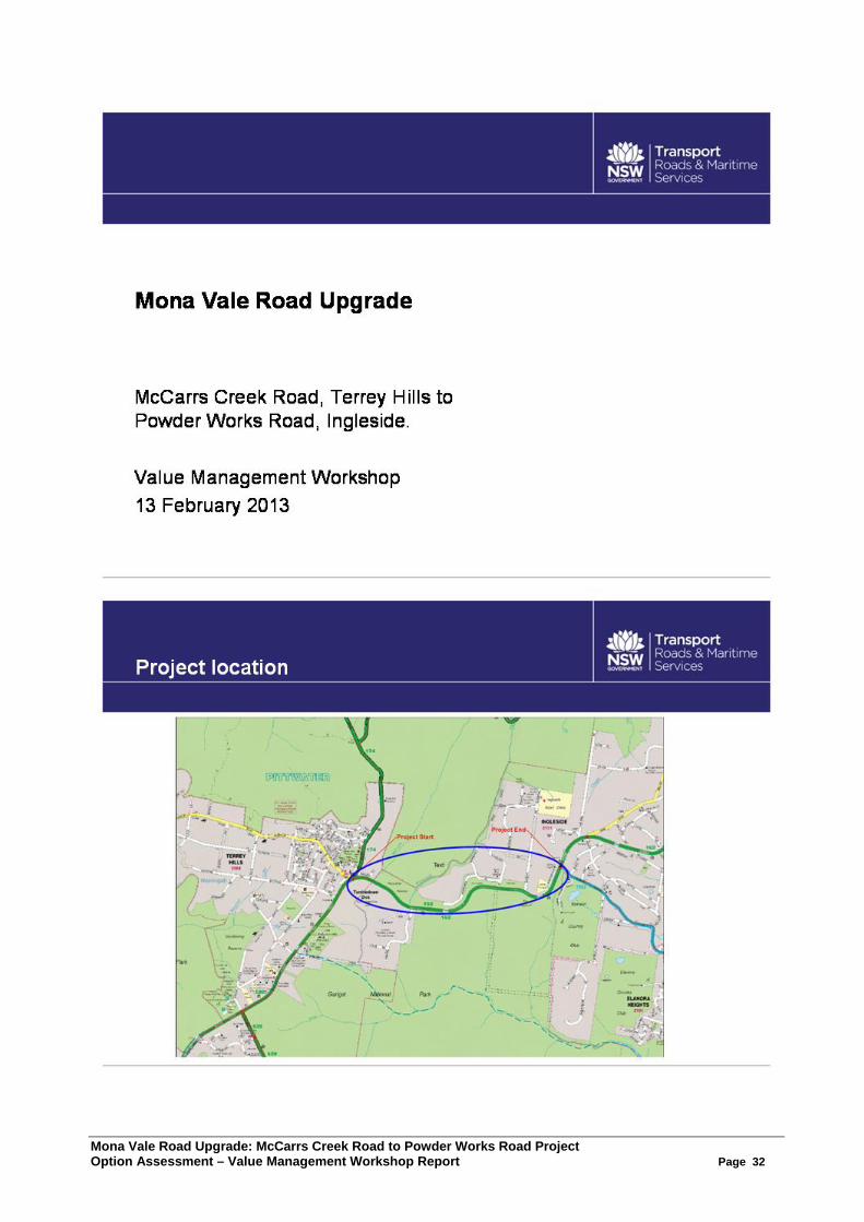
Mona Vale Road Upgrade: McCarrs Creek Road to Powder Works Road Project Option Assessment – Value Management Workshop Report Page 32
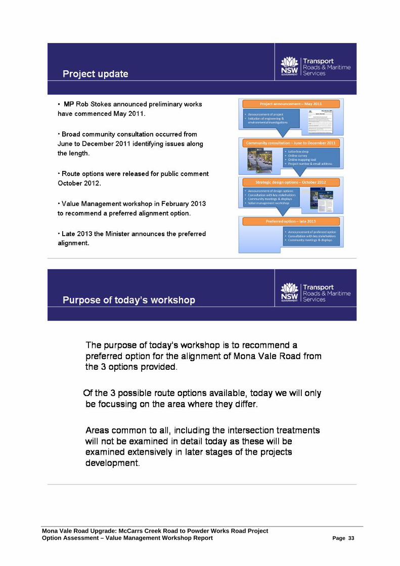
Mona Vale Road Upgrade: McCarrs Creek Road to Powder Works Road Project Option Assessment – Value Management Workshop Report Page 33
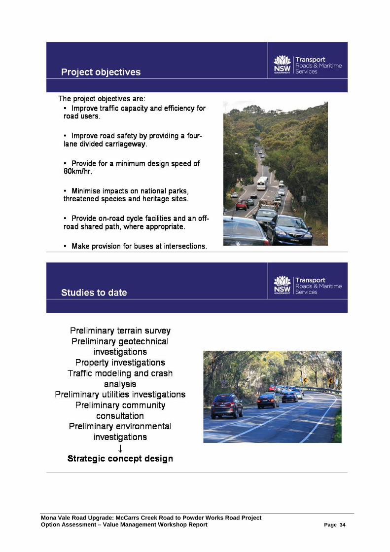
Mona Vale Road Upgrade: McCarrs Creek Road to Powder Works Road Project Option Assessment – Value Management Workshop Report Page 34
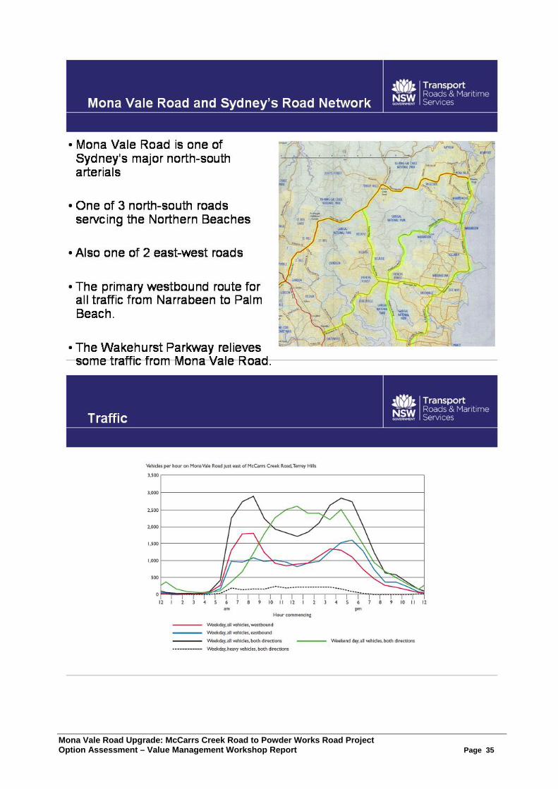
Mona Vale Road Upgrade: McCarrs Creek Road to Powder Works Road Project Option Assessment – Value Management Workshop Report Page 35
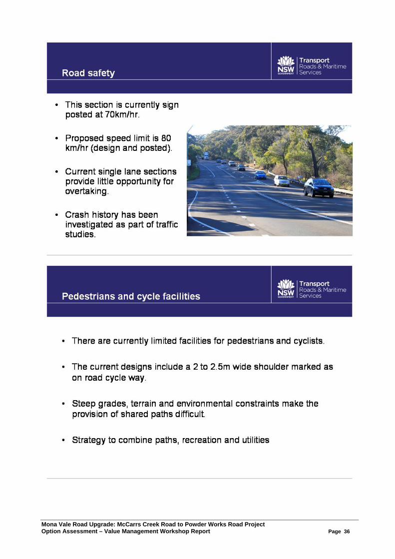
Mona Vale Road Upgrade: McCarrs Creek Road to Powder Works Road Project Option Assessment – Value Management Workshop Report Page 36

Mona Vale Road Upgrade: McCarrs Creek Road to Powder Works Road Project Option Assessment – Value Management Workshop Report Page 37
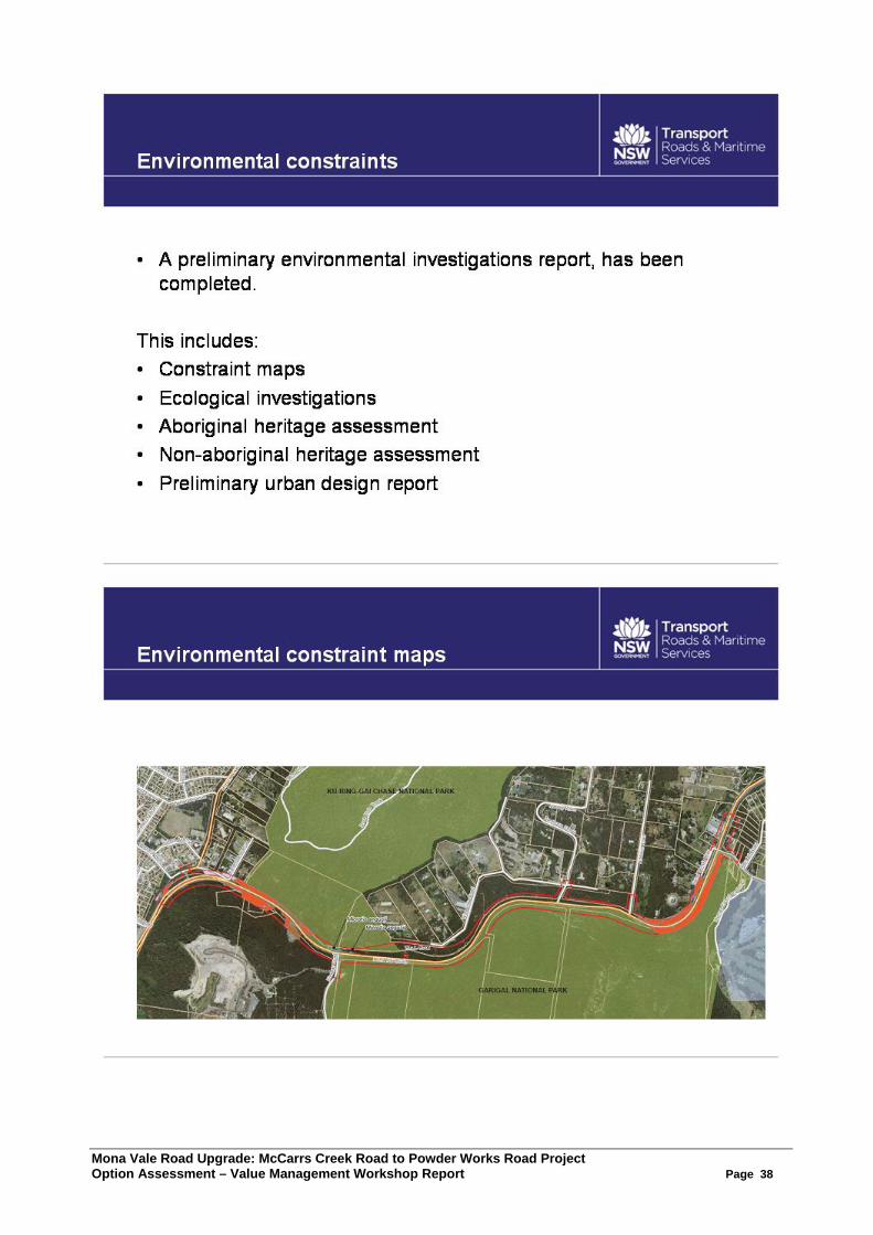
Mona Vale Road Upgrade: McCarrs Creek Road to Powder Works Road Project Option Assessment – Value Management Workshop Report Page 38
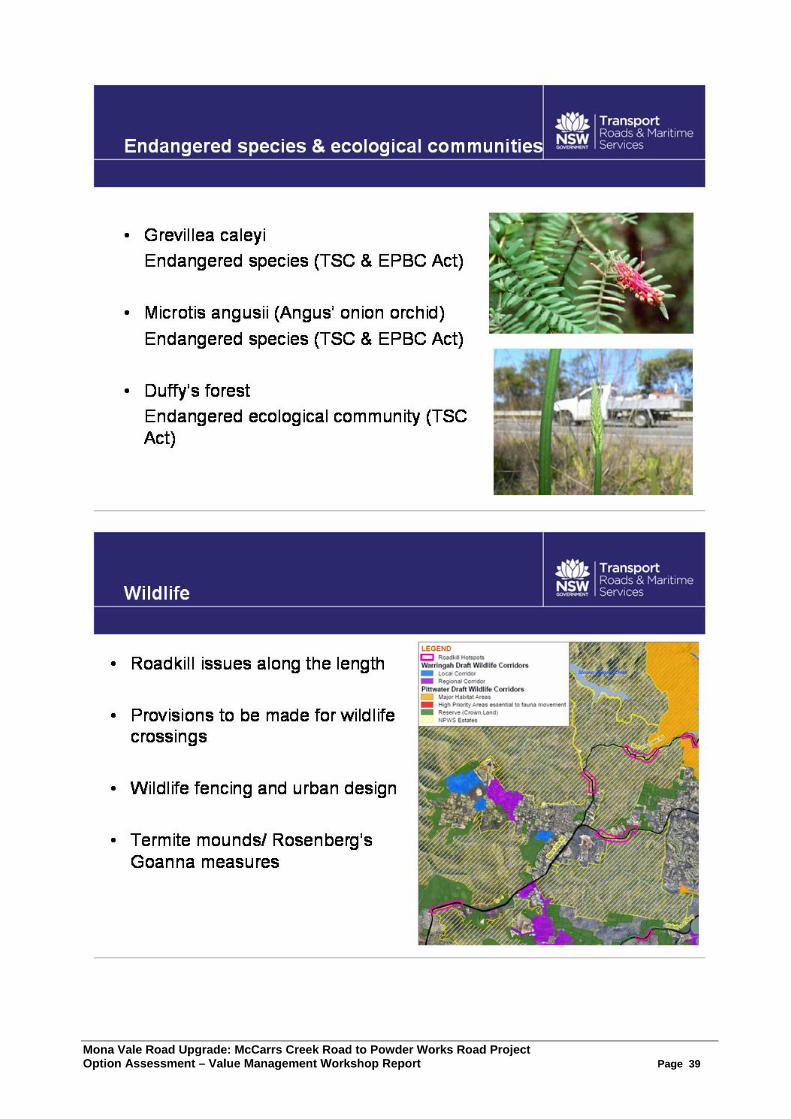
Mona Vale Road Upgrade: McCarrs Creek Road to Powder Works Road Project Option Assessment – Value Management Workshop Report Page 39
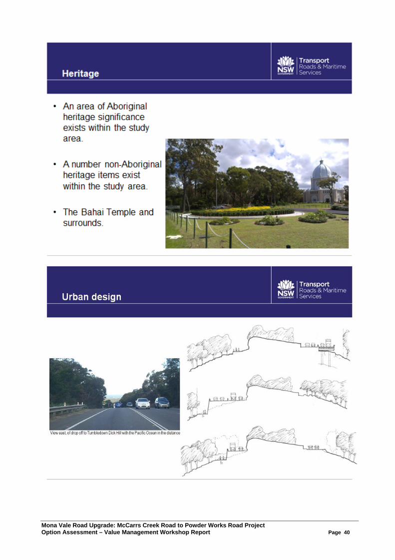
Mona Vale Road Upgrade: McCarrs Creek Road to Powder Works Road Project Option Assessment – Value Management Workshop Report Page 40

Mona Vale Road Upgrade: McCarrs Creek Road to Powder Works Road Project Option Assessment – Value Management Workshop Report Page 41
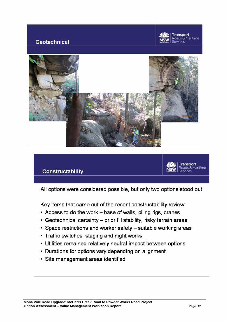
Mona Vale Road Upgrade: McCarrs Creek Road to Powder Works Road Project Option Assessment – Value Management Workshop Report Page 42
Mona Vale Road Upgrade: McCarrs Creek Road to Powder Works Road Project Option Assessment – Value Management Workshop Report Page 43
Appendix 5. Options Presentation
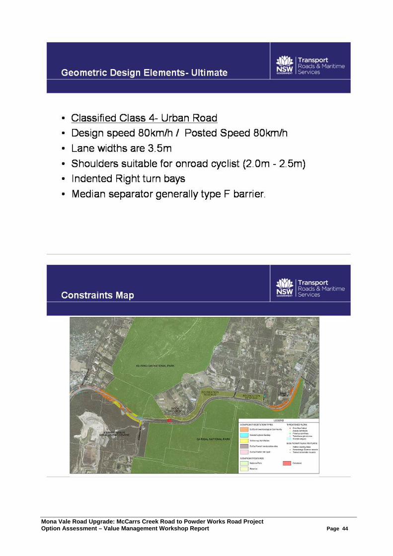
Mona Vale Road Upgrade: McCarrs Creek Road to Powder Works Road Project Option Assessment – Value Management Workshop Report Page 44
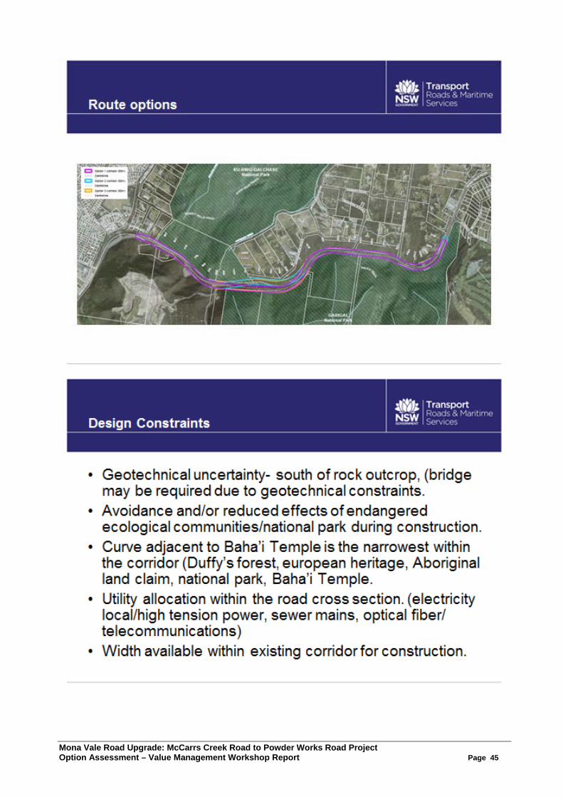
Mona Vale Road Upgrade: McCarrs Creek Road to Powder Works Road Project Option Assessment – Value Management Workshop Report Page 45
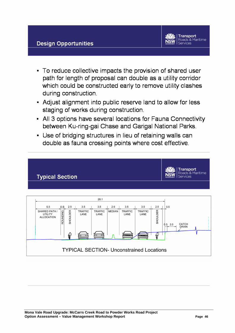
Mona Vale Road Upgrade: McCarrs Creek Road to Powder Works Road Project Option Assessment – Value Management Workshop Report Page 46
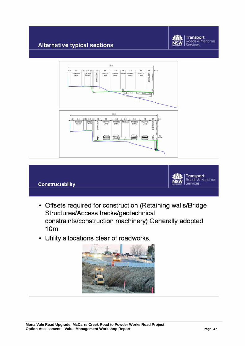
Mona Vale Road Upgrade: McCarrs Creek Road to Powder Works Road Project Option Assessment – Value Management Workshop Report Page 47
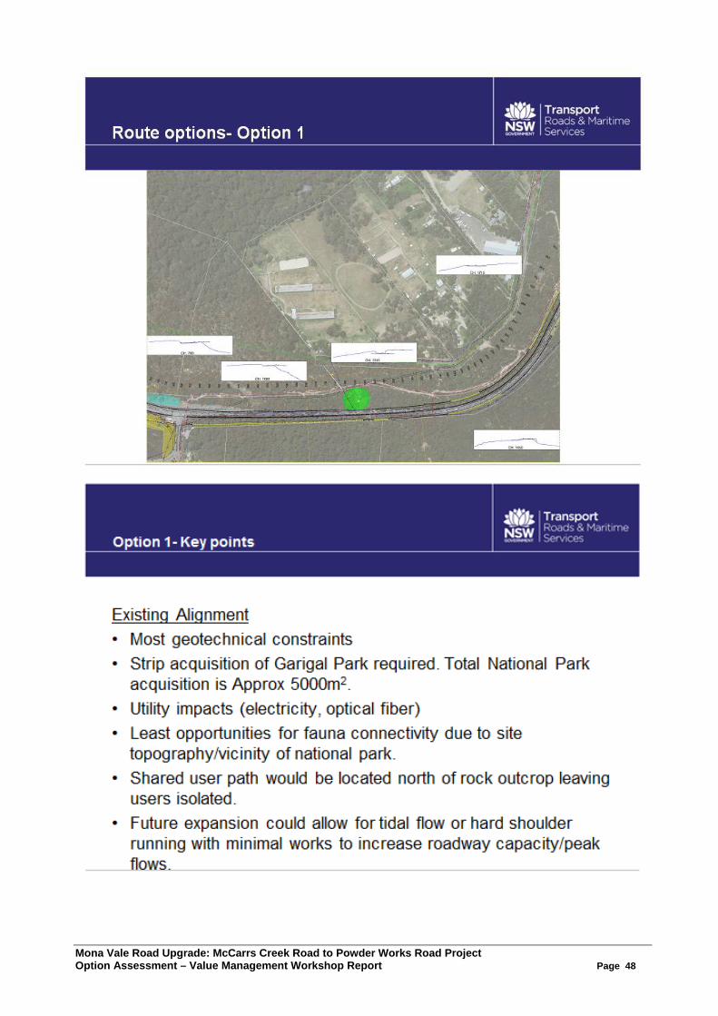
Mona Vale Road Upgrade: McCarrs Creek Road to Powder Works Road Project Option Assessment – Value Management Workshop Report Page 48
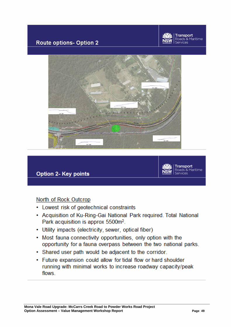
Mona Vale Road Upgrade: McCarrs Creek Road to Powder Works Road Project Option Assessment – Value Management Workshop Report Page 49

Mona Vale Road Upgrade: McCarrs Creek Road to Powder Works Road Project Option Assessment – Value Management Workshop Report Page 50