Embed Size (px)
Citation preview
Available online at www.sciencedirect.com
l Research 170 (2008) 111–120www.elsevier.com/locate/jvolgeores
Journal of Volcanology and Geotherma
Mountain of sustenance, mountain of destruction: The prehispanicexperience with Popocatépetl Volcano
P. Plunket ⁎, G. Uruñuela 1
Departamento de Antropología, Universidad de las Américas-Puebla, Sta. Catarina Mártir, 72820 Cholula, Puebla, México
Received 6 July 2006Available online 5 October 2007
Abstract
Twelve seasons of work have documented two temporally distinct sets of prehispanic houses and agricultural fields buried by pumiceous airfalldeposits at Tetimpa on the northeastern flank of Volcán Popocatépetl in the state of Puebla, Mexico. Archaeological survey and excavation, inaddition to stratigraphic, volcanologic, and geomorphic field methods and radiocarbon dating have been used to gather information on two majorvolcanic eruptions that devastated prehispanic settlements and rendered this region uninhabitable for generations, first about 2000 years BP andthen again between AD 700 and 900. Impacts of these eruptions were probably responsible for many of the population shifts evident in thearchaeological record during these centuries. Available geological data are interwoven with the historical and archaeological records to summarizeand explain the most significant findings of this research.© 2007 Elsevier B.V. All rights reserved.
Keywords: Popocatépetl; eruption; Tetimpa; Cholula; natural disaster; abandonment
1. Introduction
Initial archaeological discoveries of prehispanic houses andagricultural fields buried under volcanic ash on the northeasternflank of Popocatépetl Volcano date to the 1960s when localcommunities began to excavate the tephra to make cinder blockin small cottage industries (Tschohl and Nickel, 1972; Seele,1973). In the early 1990s, miners introduced large front-endloaders to extract the pumice, greatly accelerating the destructionof the buried ancient settlements. After the onset of Popocaté-petl's current eruption in 1994, evacuation routes were paved,providing yet easier access to the pumice quarries and makingthe documentation of the archaeological remains even moreurgent.
In November 1993, archaeologists from the Universidad de lasAméricas in Cholula, Puebla, began a long-term research projectdesigned to study the impact of Popocatépetl's volcanic activity
⁎ Corresponding author. Tel./fax: +52 222 229 2048.E-mail addresses: [email protected] (P. Plunket),
[email protected] (G. Uruñuela).1 Fax: +52 222 229 2048.
0377-0273/$ - see front matter © 2007 Elsevier B.V. All rights reserved.doi:10.1016/j.jvolgeores.2007.09.012
on the prehispanic settlements of the western Puebla-TlaxcalaValley in centralMexico. Twelve field seasons (1993–2005) havefocused on the Tetimpa region, a 20 km2 area located between thetowns of San Nicolás de los Ranchos and San BuenaventuraNealtican on the northeastern flank of the mountain in the state ofPuebla (Fig. 1). Archaeological survey and excavation – inaddition to stratigraphic, volcanologic, and geomorphic fieldmethods and radiocarbon dating – have been used to gatherinformation on two major volcanic eruptions that devastatedprehispanic settlements and rendered this region uninhabitable forgenerations. These eruptions were probably responsible for manyof the population shifts evident in the archaeological recordduring the first and eighth centuries AD (Sanders et al., 1979;Siebe et al., 2004; Uruñuela and Plunket, 2005).
Research has focused on the following aspects: (1) determi-nation of the extent and timing of human occupation in the area;(2) reconstruction of the social, political, and ritual patterning invillage organization; (3) identification of subsistence strategiesand exchange networks; (4) accurate dating of the volcaniceruptions visible in local stratigraphy; (5) establishment of thelateral impact of the volcanic events; and (6) understanding ofabandonment processes and the sociopolitical aftermath of major
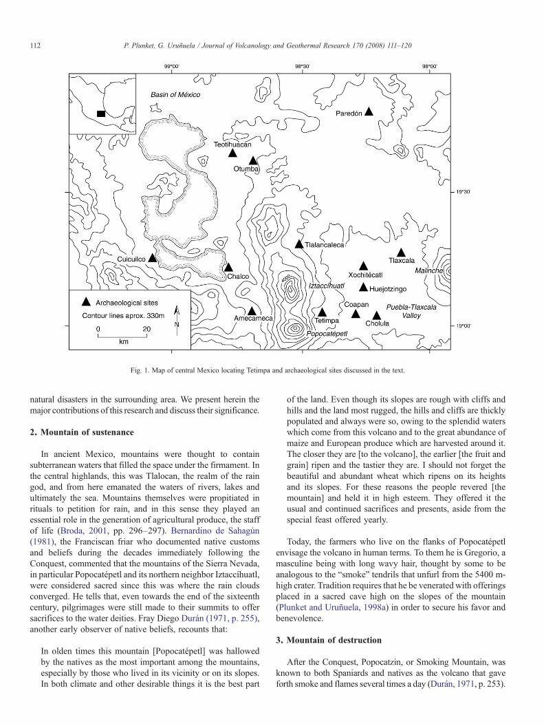
Fig. 1. Map of central Mexico locating Tetimpa and archaeological sites discussed in the text.
112 P. Plunket, G. Uruñuela / Journal of Volcanology and Geothermal Research 170 (2008) 111–120
natural disasters in the surrounding area. We present herein themajor contributions of this research and discuss their significance.
2. Mountain of sustenance
In ancient Mexico, mountains were thought to containsubterranean waters that filled the space under the firmament. Inthe central highlands, this was Tlalocan, the realm of the raingod, and from here emanated the waters of rivers, lakes andultimately the sea. Mountains themselves were propitiated inrituals to petition for rain, and in this sense they played anessential role in the generation of agricultural produce, the staffof life (Broda, 2001, pp. 296–297). Bernardino de Sahagún(1981), the Franciscan friar who documented native customsand beliefs during the decades immediately following theConquest, commented that the mountains of the Sierra Nevada,in particular Popocatépetl and its northern neighbor Iztaccíhuatl,were considered sacred since this was where the rain cloudsconverged. He tells that, even towards the end of the sixteenthcentury, pilgrimages were still made to their summits to offersacrifices to the water deities. Fray Diego Durán (1971, p. 255),another early observer of native beliefs, recounts that:
In olden times this mountain [Popocatépetl] was hallowedby the natives as the most important among the mountains,especially by those who lived in its vicinity or on its slopes.In both climate and other desirable things it is the best part
of the land. Even though its slopes are rough with cliffs andhills and the land most rugged, the hills and cliffs are thicklypopulated and always were so, owing to the splendid waterswhich come from this volcano and to the great abundance ofmaize and European produce which are harvested around it.The closer they are [to the volcano], the earlier [the fruit andgrain] ripen and the tastier they are. I should not forget thebeautiful and abundant wheat which ripens on its heightsand its slopes. For these reasons the people revered [themountain] and held it in high esteem. They offered it theusual and continued sacrifices and presents, aside from thespecial feast offered yearly.
Today, the farmers who live on the flanks of Popocatépetlenvisage the volcano in human terms. To them he is Gregorio, amasculine being with long wavy hair, thought by some to beanalogous to the “smoke” tendrils that unfurl from the 5400 m-high crater. Tradition requires that he be venerated with offeringsplaced in a sacred cave high on the slopes of the mountain(Plunket and Uruñuela, 1998a) in order to secure his favor andbenevolence.
3. Mountain of destruction
After the Conquest, Popocatzin, or Smoking Mountain, wasknown to both Spaniards and natives as the volcano that gaveforth smoke and flames several times a day (Durán, 1971, p. 253).
113P. Plunket, G. Uruñuela / Journal of Volcanology and Geothermal Research 170 (2008) 111–120
Since the fourteenth century, it has erupted over 30 times(Sigurdsson, 2000, p. 1379), but none of those events had majordestructive consequences. Ancient Aztec legend, however, creditsnatural forces like wind, floods, and volcanic eruptions with thedestruction of previous worlds in an ongoing cycle of creationand destruction, and affirms that the third creation, or sun, wasannihilated by a massive eruption, a rain of fire, which caused therocks to boil and turn red (Bierhorst, 1992; Sullivan and Knab,1994, p. 66).
Two major eruptions that occurred during prehispanic timesmay have provided the basis for Aztec legends (Seele, 1973;Panfil, 1996; Siebe et al., 1996; Plunket and Uruñuela, 1998b).The earliest of these was a VEI-6 plinian event that took placeduring the first century AD; this explosive eruption produceda tephra column between 20 and 30 km high and depositedN3.2 km3 of yellow andesitic pumice over an area extending atleast 25 km east of the crater (Panfil, 1996, p. 16; Siebe, 2000,p. 61). It buried at least one large village with lapilli, causing theabandonment of the settlement (Plunket and Uruñuela, 2003;Uruñuela and Plunket, 2003). Following the plinian phase, thick(30–100 m) olivine andesitic lava flows – now known as thePedregal de Nealtican – covered about 50 km2 of the easternpiedmont of the volcano and in places dammed and diverteddrainages, altering the surface hydrology of the western PueblaValley (Panfil, 1996, pp., 16–20). Tetimpa, which in the nativeNahuatl language means “place filled up with rock” (Karttunen,1983, p. 234), is the local name for the area impacted by theplinian phase of this eruption.
At least 400 years passed before the Tetimpa region wasreoccupied. Organic accumulations and a sandy matrix define aweak A soil horizon in the upper 15–40 cm of the pumice(Panfil, 1996, p. 21), and this appears to have been sufficient to
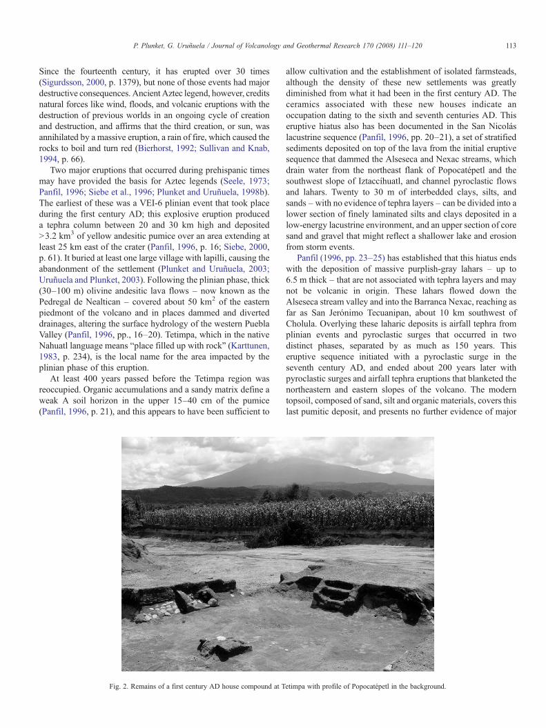
Fig. 2. Remains of a first century AD house compound at T
allow cultivation and the establishment of isolated farmsteads,although the density of these new settlements was greatlydiminished from what it had been in the first century AD. Theceramics associated with these new houses indicate anoccupation dating to the sixth and seventh centuries AD. Thiseruptive hiatus also has been documented in the San Nicoláslacustrine sequence (Panfil, 1996, pp. 20–21), a set of stratifiedsediments deposited on top of the lava from the initial eruptivesequence that dammed the Alseseca and Nexac streams, whichdrain water from the northeast flank of Popocatépetl and thesouthwest slope of Iztaccíhuatl, and channel pyroclastic flowsand lahars. Twenty to 30 m of interbedded clays, silts, andsands –with no evidence of tephra layers – can be divided into alower section of finely laminated silts and clays deposited in alow-energy lacustrine environment, and an upper section of coresand and gravel that might reflect a shallower lake and erosionfrom storm events.
Panfil (1996, pp. 23–25) has established that this hiatus endswith the deposition of massive purplish-gray lahars – up to6.5 m thick – that are not associated with tephra layers and maynot be volcanic in origin. These lahars flowed down theAlseseca stream valley and into the Barranca Nexac, reaching asfar as San Jerónimo Tecuanipan, about 10 km southwest ofCholula. Overlying these laharic deposits is airfall tephra fromplinian events and pyroclastic surges that occurred in twodistinct phases, separated by as much as 150 years. Thiseruptive sequence initiated with a pyroclastic surge in theseventh century AD, and ended about 200 years later withpyroclastic surges and airfall tephra eruptions that blanketed thenortheastern and eastern slopes of the volcano. The moderntopsoil, composed of sand, silt and organic materials, covers thislast pumitic deposit, and presents no further evidence of major
etimpa with profile of Popocatépetl in the background.
114 P. Plunket, G. Uruñuela / Journal of Volcanology and Geothermal Research 170 (2008) 111–120
volcanic events on the northeastern flank of the volcano (Siebeet al., 1996; Panfil et al., 1999).
4. Radiocarbon dating
The primary contexts afforded by Tetimpa's domesticstructures, activity areas, and agricultural fields provide reliabledating for both of the eruptive sequences considered here sincethey were in use when the disasters occurred (Figs. 2 and 3).They include burned roofing materials, charcoal from hearths,food left in storage bins, and charred remains of cultivatedplants that have permitted us to reliably constrain the naturalevents by radiocarbon dating.
The most reliable date for the first eruption is an AMS(Accelerator Mass Spectrometer) determination on a carbonizedcorn cob found sealed inside a jar, which yielded a reading of2010±40 BP (2 Sigma range of cal 100 BC–AD 70 [Beta-146572]). This, 13 additional radiocarbon dates, and the culturalartifacts recovered from the houses buried by the tephra, indicatethat the initial eruption probably took place during the first halfof the first century AD.
Although the second eruption was equally destructive as thefirst, it is lesswell dated. The small settlements on the northeastern
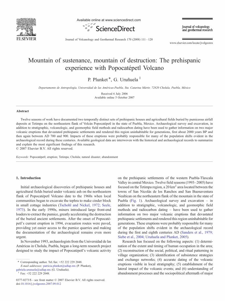
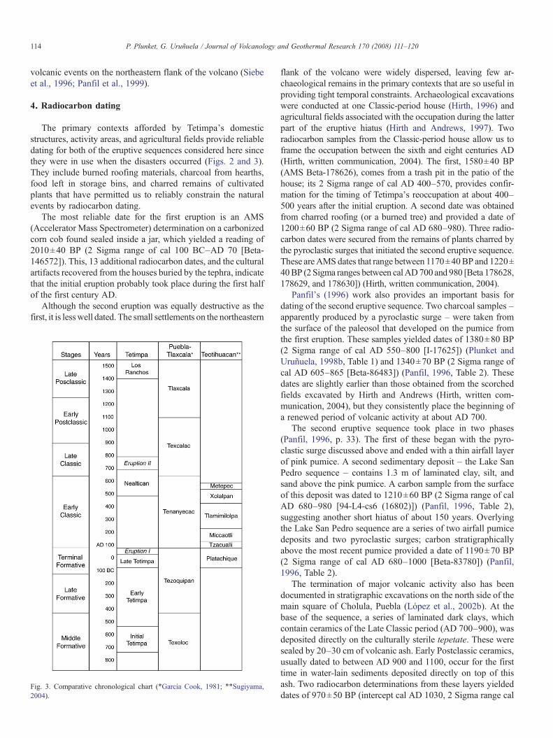
Fig. 3. Comparative chronological chart (⁎García Cook, 1981; ⁎⁎Sugiyama,2004).
flank of the volcano were widely dispersed, leaving few ar-chaeological remains in the primary contexts that are so useful inproviding tight temporal constraints. Archaeological excavationswere conducted at one Classic-period house (Hirth, 1996) andagricultural fields associated with the occupation during the latterpart of the eruptive hiatus (Hirth and Andrews, 1997). Tworadiocarbon samples from the Classic-period house allow us toframe the occupation between the sixth and eight centuries AD(Hirth, written communication, 2004). The first, 1580±40 BP(AMS Beta-178626), comes from a trash pit in the patio of thehouse; its 2 Sigma range of cal AD 400–570, provides confir-mation for the timing of Tetimpa's reoccupation at about 400–500 years after the initial eruption. A second date was obtainedfrom charred roofing (or a burned tree) and provided a date of1200±60 BP (2 Sigma range of cal AD 680–980). Three radio-carbon dates were secured from the remains of plants charred bythe pyroclastic surges that initiated the second eruptive sequence.These are AMS dates that range between 1170±40BP and 1220±40BP (2 Sigma ranges between calAD700 and 980 [Beta 178628,178629, and 178630]) (Hirth, written communication, 2004).
Panfil's (1996) work also provides an important basis fordating of the second eruptive sequence. Two charcoal samples –apparently produced by a pyroclastic surge – were taken fromthe surface of the paleosol that developed on the pumice fromthe first eruption. These samples yielded dates of 1380±80 BP(2 Sigma range of cal AD 550–800 [I-17625]) (Plunket andUruñuela, 1998b, Table 1) and 1340±70 BP (2 Sigma range ofcal AD 605–865 [Beta-86483]) (Panfil, 1996, Table 2). Thesedates are slightly earlier than those obtained from the scorchedfields excavated by Hirth and Andrews (Hirth, written com-munication, 2004), but they consistently place the beginning ofa renewed period of volcanic activity at about AD 700.
The second eruptive sequence took place in two phases(Panfil, 1996, p. 33). The first of these began with the pyro-clastic surge discussed above and ended with a thin airfall layerof pink pumice. A second sedimentary deposit – the Lake SanPedro sequence – contains 1.3 m of laminated clay, silt, andsand above the pink pumice. A carbon sample from the surfaceof this deposit was dated to 1210±60 BP (2 Sigma range of calAD 680–980 [94-L4-cs6 (16802)]) (Panfil, 1996, Table 2),suggesting another short hiatus of about 150 years. Overlyingthe Lake San Pedro sequence are a series of two airfall pumicedeposits and two pyroclastic surges; carbon stratigraphicallyabove the most recent pumice provided a date of 1190±70 BP(2 Sigma range of cal AD 680–1000 [Beta-83780]) (Panfil,1996, Table 2).
The termination of major volcanic activity also has beendocumented in stratigraphic excavations on the north side of themain square of Cholula, Puebla (López et al., 2002b). At thebase of the sequence, a series of laminated dark clays, whichcontain ceramics of the Late Classic period (AD 700–900), wasdeposited directly on the culturally sterile tepetate. These weresealed by 20–30 cm of volcanic ash. Early Postclassic ceramics,usually dated to between AD 900 and 1100, occur for the firsttime in water-lain sediments deposited directly on top of thisash. Two radiocarbon determinations from these layers yieldeddates of 970±50 BP (intercept cal AD 1030, 2 Sigma range cal
115P. Plunket, G. Uruñuela / Journal of Volcanology and Geothermal Research 170 (2008) 111–120
AD 990–1185 [Beta-188340]) and 1040±130 BP (intercept calAD 1005, 2 Sigma range cal AD 690–1260 [Beta-188341]),confirming Panfil's finding that Popocatépetl's second eruptivesequence had ended prior to AD 1000 (Plunket and Uruñuela,2005a).
5. The first occupation
Tetimpa was initially settled between 800 and 700 BC as partof a gradual agricultural expansion into the forested piedmont ofthe Sierra Nevada. By the beginning of the first century AD, ithad grown into a large dispersed village with over 600 wattle-and-daub houses – perhaps 3000 to 4000 people – and a numberof non-residential structures that spread over 4 km2. The houseswere built according to a standardized module consisting of alarge central room used for family ritual flanked by two smallerlateral structures for sleeping and cooking (Plunket andUruñuela, 1998a). Together they frame a courtyard with anancestral shrine, wattle-and-daub storage bins, and remains ofhousehold subsistence activities (Uruñuela and Plunket, 1998,2003).
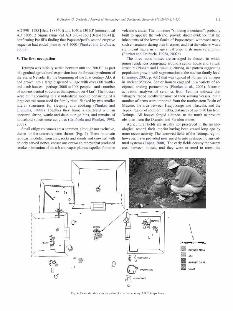
Small effigy volcanoes are a common, although not exclusive,theme for the domestic patio shrines (Fig. 4). These mountainreplicas, modeled from clay, rocks and sherds and crowned withcrudely carved stones, encase one or two chimneys that producedsmoke in imitation of the ash and vapor plumes expelled from the
Fig. 4. Domestic shrine in the patio of a
volcano's crater. The miniature “smoking mountains”, probablybuilt to appease the volcano, provide direct evidence that theinhabitants of the lower flanks of Popocatépetl witnessed manysuch emanations during their lifetimes, and that the volcano was asignificant figure in village ritual prior to its massive eruption(Plunket and Uruñuela, 1998a, 2002a).
The three-room houses are arranged in clusters in whichjunior residences congregate around a senior house and a ritualstructure (Plunket and Uruñuela, 2005b), in a pattern suggestingpopulation growth with segmentation at the nuclear family level(Flannery, 2002, p. 431) that was typical of Formative villagesin ancient Mexico. Senior houses engaged in a variety of re-ciprocal trading partnerships (Plunket et al., 2005). Neutronactivation analyses of ceramics from Tetimpa indicate thatvillagers traded locally for most of their serving vessels, but anumber of items were imported from the northeastern Basin ofMexico, the area between Huejotzingo and Tlaxcala, and theTepexi region of southern Puebla, distances of up to 80 km fromTetimpa. All houses forged alliances to the north to procureobsidian from the Otumba and Paredón mines.
Agricultural fields are usually not preserved in the archae-ological record, their imprint having been erased long ago bymore recent activity. The furrowed fields of the Tetimpa region,however, have provided new insights into prehispanic agricul-tural systems (López, 2000). The early fields occupy the vacantarea between houses, and they were oriented to arrest the
t a first century AD Tetimpa house.
116 P. Plunket, G. Uruñuela / Journal of Volcanology and Geothermal Research 170 (2008) 111–120
erosion of the sandy piedmont soil, and perhaps increased waterabsorption. Furrows are spaced regularly at intervals of 1–1.3 mapart and macrobotanical remains indicate that they probablyrepresent milpa agriculture (Aguirre, 2000). More compactfurrow systems with only 0.45–0.85 m between furrows arevestiges of orchards and gardens (López, 2000).
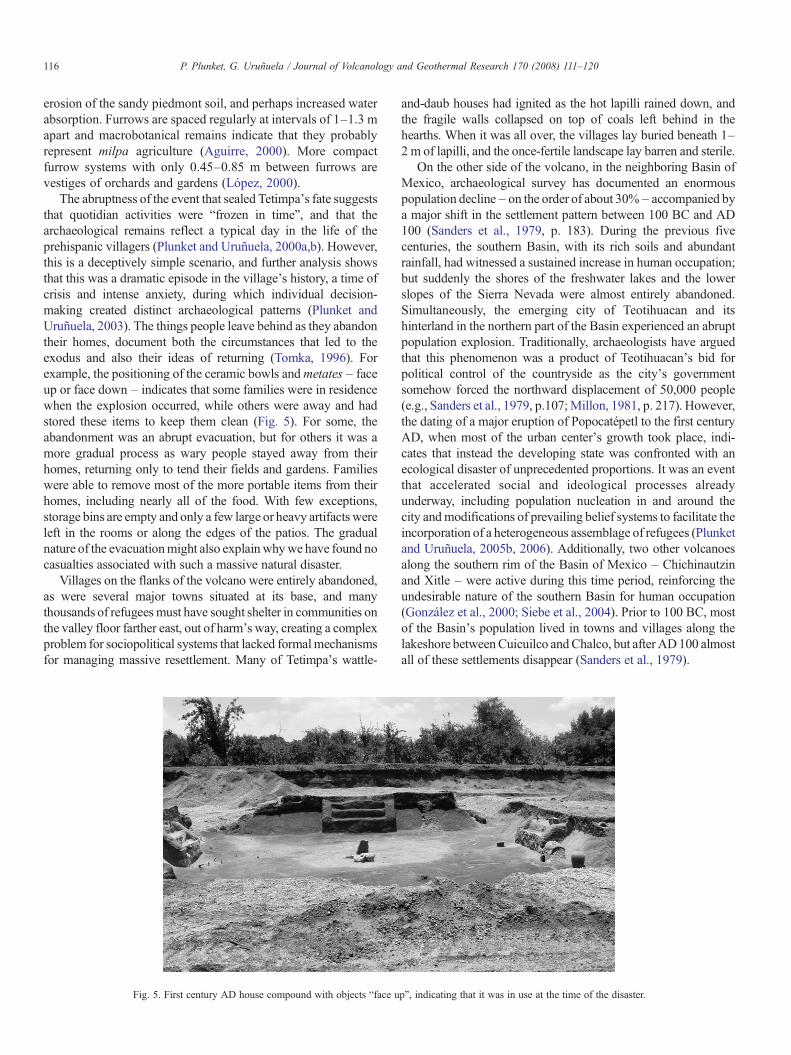
The abruptness of the event that sealed Tetimpa's fate suggeststhat quotidian activities were “frozen in time”, and that thearchaeological remains reflect a typical day in the life of theprehispanic villagers (Plunket and Uruñuela, 2000a,b). However,this is a deceptively simple scenario, and further analysis showsthat this was a dramatic episode in the village's history, a time ofcrisis and intense anxiety, during which individual decision-making created distinct archaeological patterns (Plunket andUruñuela, 2003). The things people leave behind as they abandontheir homes, document both the circumstances that led to theexodus and also their ideas of returning (Tomka, 1996). Forexample, the positioning of the ceramic bowls andmetates – faceup or face down – indicates that some families were in residencewhen the explosion occurred, while others were away and hadstored these items to keep them clean (Fig. 5). For some, theabandonment was an abrupt evacuation, but for others it was amore gradual process as wary people stayed away from theirhomes, returning only to tend their fields and gardens. Familieswere able to remove most of the more portable items from theirhomes, including nearly all of the food. With few exceptions,storage bins are empty and only a few large or heavy artifacts wereleft in the rooms or along the edges of the patios. The gradualnature of the evacuationmight also explainwhywe have found nocasualties associated with such a massive natural disaster.
Villages on the flanks of the volcano were entirely abandoned,as were several major towns situated at its base, and manythousands of refugees must have sought shelter in communities onthe valley floor farther east, out of harm's way, creating a complexproblem for sociopolitical systems that lacked formalmechanismsfor managing massive resettlement. Many of Tetimpa's wattle-
Fig. 5. First century AD house compound with objects “face u
and-daub houses had ignited as the hot lapilli rained down, andthe fragile walls collapsed on top of coals left behind in thehearths. When it was all over, the villages lay buried beneath 1–2 m of lapilli, and the once-fertile landscape lay barren and sterile.
On the other side of the volcano, in the neighboring Basin ofMexico, archaeological survey has documented an enormouspopulation decline– on the order of about 30%– accompanied bya major shift in the settlement pattern between 100 BC and AD100 (Sanders et al., 1979, p. 183). During the previous fivecenturies, the southern Basin, with its rich soils and abundantrainfall, had witnessed a sustained increase in human occupation;but suddenly the shores of the freshwater lakes and the lowerslopes of the Sierra Nevada were almost entirely abandoned.Simultaneously, the emerging city of Teotihuacan and itshinterland in the northern part of the Basin experienced an abruptpopulation explosion. Traditionally, archaeologists have arguedthat this phenomenon was a product of Teotihuacan's bid forpolitical control of the countryside as the city's governmentsomehow forced the northward displacement of 50,000 people(e.g., Sanders et al., 1979, p.107;Millon, 1981, p. 217). However,the dating of a major eruption of Popocatépetl to the first centuryAD, when most of the urban center's growth took place, indi-cates that instead the developing state was confronted with anecological disaster of unprecedented proportions. It was an eventthat accelerated social and ideological processes alreadyunderway, including population nucleation in and around thecity andmodifications of prevailing belief systems to facilitate theincorporation of a heterogeneous assemblage of refugees (Plunketand Uruñuela, 2005b, 2006). Additionally, two other volcanoesalong the southern rim of the Basin of Mexico – Chichinautzinand Xitle – were active during this time period, reinforcing theundesirable nature of the southern Basin for human occupation(González et al., 2000; Siebe et al., 2004). Prior to 100 BC, mostof the Basin's population lived in towns and villages along thelakeshore betweenCuicuilco andChalco, but after AD100 almostall of these settlements disappear (Sanders et al., 1979).
p”, indicating that it was in use at the time of the disaster.
117P. Plunket, G. Uruñuela / Journal of Volcanology and Geothermal Research 170 (2008) 111–120
6. The second occupation
About AD 500, human populations resettled the Tetimparegion, farming the thin soil that was slowly developing on thepumiceous ash. It is much more difficult to document theClassic occupation, because it is situated in between tephradeposits and is usually entirely destroyed when these areextracted by the front-end loaders. The one excavated house(Hirth, 1996) covered well over 130 m2 (it had been partiallydestroyed by mining) and consisted of five rooms and threepatios; its spatial layout is quite distinct from the residences ofthe earlier occupation, signaling important changes in socialorganization brought about by the development of more urbanlifestyles during the eruptive hiatus.
The isolated farmsteads established during this time of calmare associated with areas of greater soil accumulation. TheClassic period agricultural furrows are limited in extent, duemainly to the meager and uneven soil development, but theyprovide singular evidence of the strategies employed to salvageand replant fields after the renewal of volcanic activity in theeighth century AD. Hirth and Andrews (1997) found that, afterthe furrows were buried under the 10–15 cm layer of ash andpink pumice, the farmers excavated them so that they could bereplanted, thus reworking the pumice into the paleosol. Detailedstratigraphic excavations document how this process wasrepeated at least one more time before farmers were forced toabandon the area when a 15–30 cm layer of tephra blanketed thenortheastern slope of Popocatépetl.
Siebe et al. (1996) have suggested that the second eruptivesequence resulted in massive lahars that swept into the westernPuebla Valley and destroyed the city of Cholula. Their recon-struction is based on examination of the deposits – which theyidentify as lahars of volcanic origin – that overlie the Classic
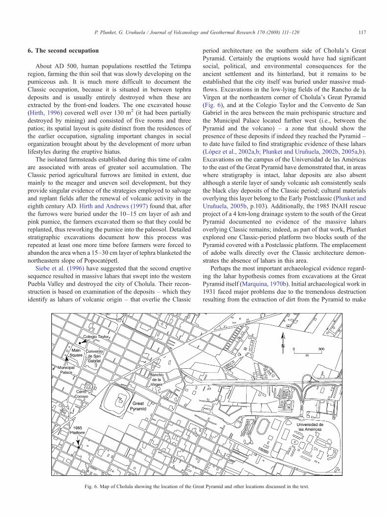
Fig. 6. Map of Cholula showing the location of the Grea
period architecture on the southern side of Cholula's GreatPyramid. Certainly the eruptions would have had significantsocial, political, and environmental consequences for theancient settlement and its hinterland, but it remains to beestablished that the city itself was buried under massive mud-flows. Excavations in the low-lying fields of the Rancho de laVirgen at the northeastern corner of Cholula's Great Pyramid(Fig. 6), and at the Colegio Taylor and the Convento de SanGabriel in the area between the main prehispanic structure andthe Municipal Palace located further west (i.e., between thePyramid and the volcano) – a zone that should show thepresence of these deposits if indeed they reached the Pyramid –to date have failed to find stratigraphic evidence of these lahars(López et al., 2002a,b; Plunket and Uruñuela, 2002b, 2005a,b).Excavations on the campus of the Universidad de las Américasto the east of the Great Pyramid have demonstrated that, in areaswhere stratigraphy is intact, lahar deposits are also absentalthough a sterile layer of sandy volcanic ash consistently sealsthe black clay deposits of the Classic period; cultural materialsoverlying this layer belong to the Early Postclassic (Plunket andUruñuela, 2005b, p.103). Additionally, the 1985 INAH rescueproject of a 4 km-long drainage system to the south of the GreatPyramid documented no evidence of the massive laharsoverlying Classic remains; indeed, as part of that work, Plunketexplored one Classic-period platform two blocks south of thePyramid covered with a Postclassic platform. The emplacementof adobe walls directly over the Classic architecture demon-strates the absence of lahars in this area.
Perhaps the most important archaeological evidence regard-ing the lahar hypothesis comes from excavations at the GreatPyramid itself (Marquina, 1970b). Initial archaeological work in1931 faced major problems due to the tremendous destructionresulting from the extraction of dirt from the Pyramid to make
t Pyramid and other locations discussed in the text.
118 P. Plunket, G. Uruñuela / Journal of Volcanology and Geothermal Research 170 (2008) 111–120
adobes, the continuous plowing of the surface, and the roadsand ramps used to read the church on top (Marquina, 1970a,p. 33). All of these activities led to extensive erosion, which leftdeep deposits covering the flanks of the building.
On the west side of the monument, a 12 by 24 m excavationreached a depth of 5.6m, terminating at a stucco floor laid directlyon sterile subsoil. The stratigraphy of the deposits over the floor(Acosta, 1970, Fig. 20) shows 0.4 m of eroded Late Classicmaterials covering the last construction phase on this side of thePyramid; these, in turn, are sealed by 1.6 m of Early Postclassicremains. No structures or burials were found in these 2 m – a factthat might indicate that these are indeed lahars – however, theceramics in the Early Postclassic stratum (Acosta, 1970, p. 128)suggest a date between AD 950 and 1150 (Sanders et al., 1979,p. 463), well after the date proposed by Siebe and his colleagues.The archaeologists did note volcanic strata at the Pyramid, onewithin the Early Postclassic and another in the Late Postclassic(Müller, 1970), but both of these were airfall deposits.
Finally, it is important to consider that, during the latter half ofthe Classic, the Great Pyramid fronted on a large plaza boundedby a low platform on the south and another substantial mound tothe west (Cerro Cocoyo [Fig. 6], now severely mutilated). Thesestructures would not only have protected the Great Pyramid fromthe lahars, but they also would have contributed erosion materialsto the deposits excavated in the plaza. We conclude that theevidence for the destruction of Cholula by massive lahars fromPopocatépetl during the Late Classic is problematic and needs tobe reevaluated, by both geologists and archaeologists.
The transition between the Classic and Postclassic (AD 700–900) in the Puebla-Tlaxcala region represents an extremelycomplex problem (García Cook and Merino, 1991; Plunket andUruñuela, 2005b; Uruñuela and Plunket, 2005). Archaeologicalexcavations in Cholula (Dumond and Müller, 1972), in additionto work at nearby Cerro Zapotecas (Mountjoy, 1987), Cacaxtla-Xochitécatl (Serra, 1998), and the various surveys of the Puebla-Tlaxcala Valley, suggest another period of important changesduring the seventh and eighth centuries AD, including a cessationof monumental construction in Cholula, the establishment of anew politico-religious ideology linked to the Olmeca-Xicalancaof Cacaxtla (Ringle et al., 1998), the political collapse ofTeotihuacan, and the transformation of regional settlementpatterns. While some of this turbulence may have been causedby the second eruptive sequence of Popocatépetl (Siebe et al.,1996), much of it derived from the evolution of urban life and theestablishment of a class society during the Classic period (AD100–700) that created new social and political tensions. Thesecond eruptive sequence took place in a very different world thanthe first, a world of cities with a much greater organizationalcapacity; interestingly, one of these great cities – Teotihuacan –survived only as a relic of past glory, while another – Cholula –went on to become the most important religious center of allancient Mexico (Rojas, 1985).
7. Discussion
Volcanic disasters have long been invoked by archaeologistsand geologists alike as prime movers throughout history. They
have been blamed for the destruction of cities, famine, massmigrations, demographic collapse, and even the demise ofcivilizations (Hoffman, 1999; Scarth, 1999; Harris, 2000; Siebe,2000; Sigurdsson, 2000; Dull et al., 2001). Disasters, however,most often are perceived in terms of their immediate impact andnot so much as key pieces in the initiation of social, political,and economic transformations (however, see Sheets, 1979; Dullet al., 2001). Archaeological research at Tetimpa, Cholula, andother areas of the western Puebla-Tlaxcala Valley can be used tointerweave the archaeological and historical records with thegeological evidence, to better understand both the proximateand ultimate causes of culture change through time in this partof highland Mexico.
Anthropological studies of disaster have established that theseevents tend to accelerate changes that are already underway(Nolan, 1979; Driessen and McDonald, 2000). If they are of asufficiently catastrophic scale, they can motivate social action,provide contexts for innovative agendas, promote new powerrelations, and allow the emergence of new leadership (Oliver-Smith, 1996, p. 310; Hoffman, 1999, p. 311). Both the TerminalFormative (100 BC–AD 100) and Late Classic (AD 700–900)were times of rapid social transformation in central Mexico; inthis context, a major volcanic eruption would have served as acatalyst to accelerate those changes even more and highlight theinability of local authorities to deal not only with the forces ofnature, but also with unforeseen social and political consequencesderived from decision-making during the recovery process. Citieswould have arisen during the Classic period without the massiveeruption of the first century AD, but the pace of that emer-gence and the nature of the cities that evolved on either side ofPopocatépetl were highly contingent upon the volcanic event.
The Terminal Formative population of the Puebla-TlaxcalaValley has been estimated at over 100,000 (Dumond, 1972, p.119),and many of these people lived at one of several large, complexchiefdoms that developed in the fertile well-watered shadow of thevolcano. Some of them were quite close to the Sierra Nevada –e.g., Coapan, Xochitécatl, and Tlalancaleca – and they appear tohave been abandoned when Popocatépetl erupted, leading to amajor restructuring of prehispanic society during the first centuryAD. Undoubtedly many social, political, and economic factorswere in play, but a VEI-6 eruption probably prompted majorpopulation movements and political reorganization that had alasting impact on the culture history of this region.
During the Classic, much of the population became concen-trated at Cholula and a few other sites, as refugees relocated aftertheir lands were blanketed with volcanic deposits that preventedreclamation (Plunket and Uruñuela, 2000a,b). The total popula-tion of the Puebla Valley appears to shrink (Dumond, 1972,p. 115), perhaps by as much as 30% (García Cook, 1981, p. 263),just as it did in the Basin of Mexico at this same time. Of thealmost 200,000 people who perished from the effects of volcaniceruptions worldwide between AD 1600 and 1899, the majority ofthose deaths were not due to ashfalls, lahars, or pyroclastic flows,but rather resulted from starvation and diseases (Fisher et al.,1997, Table 15.3). These data demonstrate that while eruptionsare terrifying events, their ecological and social consequencesare more significant in terms of human life. Forest fires, the
119P. Plunket, G. Uruñuela / Journal of Volcanology and Geothermal Research 170 (2008) 111–120
destruction of piedmont hunting and gathering areas, drought andan increased risk of frost resulting from the explosive events,would have contributed to economic chaos and the creation of asocially charged environment in which many individuals may nothave survived.
The two major cities of the Classic period in highlandMexico,Cholula and Teotihuacan, initiated major monumental religiousconstruction towards the beginning of the second century AD(Millon et al., 1965; Marquina, 1970a; Kabata et al., 2001;Sugiyama, 2004; Plunket and Uruñuela, 2005a). How much ofthis construction was designed to appease unruly supernaturals?Scholars have observed that fear of divine vengeance motivatessocial action and that religious responses to catastrophe can behighly adaptive (e.g., Nolan, 1979, p. 331; Chester et al., 1985;Fisher et al., 1997, pp. 179–198). The huge population influxesexperienced by both emerging cities must have accelerated socialprocesses already underway before the disaster, but the enormousand sudden increase in labor resources might have been intel-ligently channeled into huge communal building projects de-signed to placate an angry deity.
Acknowledgments
We would like to thank the editors Hugo Delgado, Servandode la Cruz, and Robert Tilling for inviting us to participate in thisSpecial Issue. The generous support of the MesoamericanResearch Foundation, the Sistema Regional Ignacio Zaragoza,the Consejo Nacional de Ciencia y Tecnología, the Foundationfor the Advancement of Mesoamerican Studies, Inc., and theDecanatura de Investigación y Posgrado of the Universidad delas Américas-Puebla have made possible twelve field seasons atTetimpa. The Consejo de Arqueología of the Instituto Nacionalde Antropología e Historia granted the official permit for thisproject and has provided assistance and advice throughoutour research that are much appreciated. Comments by PaysonSheets, Robert Tilling, and an anonymous reviewer greatlyimproved the manuscript.
References
Acosta, J.R., 1970. Sección I. In: Marquina, I. (Ed.), Proyecto Cholula. SerieInvestigaciones, vol. 19. INAH, Mexico City, pp. 119–128.
Aguirre, Z.O., 2000. Estudios químicos y paleoetnobotánicos en unidades domésticasarqueológicas del sitio de Tetimpa, Puebla. UnpublishedM.A. thesis, Departmentof Anthropology, Universidad de las Américas-Puebla, Cholula.
Bierhorst, J. (translator), 1992. History and mythology of the Aztecs: The CodexChimalpopoca. University of Oklahoma Press, Norman.
Broda, J., 2001. Ritos mexicas en los cerros de la cuenca: los sacrificios deniños. In: Broda, J., Iwaniszewski, S., Montero, A. (Eds.), La montaña en elpaisaje ritual. ENAH, Mexico City, pp. 295–317.
Chester, D.K., Duncan, A.M., Guest, J.E., Kilburn, C.R.J., 1985. Mount Etna:The Anatomy of a Volcano. Stanford University Press, Stanford.
Driessen, J., McDonald, C.F., 2000. The eruption of the Santorini volcano and itseffects on Minoan Crete. In: McGuire, W.G., Griffiths, D.R., Hancock, P.L.,Stewart, I.S. (Eds.), The Archaeology of Geological Catastrophes.Geological Society Special Publications, vol. 171. The Geological Society,London, pp. 81–93.
Dull, R.A., Southon, J.R., Sheets, P., 2001. Volcanism, ecology, and culture: areassessment of the Volcán Ilopango TBJ eruption in the southernMaya realm.Latin American Antiquity 12, 25–44.
Dumond, D.E., 1972. Demographic aspects of the Classic period in Puebla-Tlaxcala. Southwestern Journal of Anthropology 28 (2), 101–130.
Dumond, D.E., Müller, F., 1972. Classic to postclassic in highland centralMexico. Science 175, 1208–1215.
Durán, D., 1971. In: Horcasitas, F., Heyden, D. (Eds.), Book of the Gods andRites and the Ancient Calendar. University of Oklahoma Press, Norman.
Fisher, R.V., Heiken, G., Hulen, J.B., 1997. Volcanos: Crucibles of Change.Princeton University Press, Princeton.
Flannery, K.V., 2002. The origins of the village revisited: from nuclear toextended households. American Antiquity 67, 417–433.
García Cook, A., 1981. The historical importance of Tlaxcala in the culturaldevelopment of the Central Highlands. In: Sabloff, J. (Ed.), Archaeology,Supplement I, Bricker, V. R. (Gen. Ed.), Handbook of Middle AmericanIndians. University of Texas Press, Austin, pp. 244–276.
García Cook, A., Merino, B.L., 1991. El Epiclásico en la región Puebla-Tlaxcala.In: García Cook, A., Merino, B.L. (Eds.), Tlaxcala: Textos de su Historia:2. Los Orígenes: Arqueología. Gobierno del Estado de Tlaxcala. CONA-CULTA, Mexico City, pp. 387–394.
González, S., Pastrana, A., Siebe, C., Duller, G., 2000. Timing of the prehistoriceruption of Xitle volcano and the abandonment of Cuicuilco pyramid, southernValley of Mexico. In: McGuire, W.G., Griffiths, D.R., Hancock, P.L., Stewart,I.S. (Eds.), The Archaeology of Geological Catastrophes. Geological SocietySpecial Publications, vol. 171. The Geological Society, London, pp. 205–224.
Harris, S.L., 2000. Archaeology and volcanism. In: Sigurdsson, H. (Ed.),Encyclopedia of Volcanoes. Academic Press, New York, pp. 1301–1314.
Hirth, K.G., 1996. La reocupación durante el Clásico. In: Uruñuela, G., Plunket,P., Informe Técnico: Temporada 1995 del Proyecto Tetimpa. Unpublishedreport submitted to the Consejo Nacional de Arqueología, INAH. ArchivoTécnico del INAH, Mexico City, pp. 80–96.
Hirth, K.G., Andrews, B., 1997. La reocupación durante el Clásico. In:Uruñuela, G., Plunket, P., Informe Técnico: Temporada 1996 del ProyectoTetimpa. Unpublished report submitted to the Consejo Nacional deArqueología, INAH. Archivo Técnico del INAH, Mexico City, pp. 78–88.
Hoffman, S., 1999. After Atlas shrugs: cultural change or persistence after adisaster. In: Oliver-Smith, A., Hoffman, S. (Eds.), The Angry Earth: Disasterin Anthropological Perspective. Routlege, London, pp. 302–325.
Kabata, S., Sugiyama, S., Aveni, A., Murakami, T., 2001. Architecturalsequence of the early monuments at the Moon Pyramid, Teotihuacan. Paperpresented to the LXVI Annual Reunion of the Society for AmericanArcahaeology, New Orleans.
Karttunen, F., 1983. An Analytical Dictionary of Nahuatl. University of TexasPress, Austin.
López, A., 2000. Dos mil años de tradición agrícola: Tecnología y organizacióndurante el Formativo Terminal en Tetimpa, Puebla. Unpublished Licencia-tura thesis, Department of Anthropology, Universidad de las Américas-Puebla, Cholula.
López, A., Talavera, S., Uruñuela, G., Plunket, P., 2002a. Sondeo aqueológicoColegio Coley B. Taylor. Unpublished report submitted to the ConsejoNacional de Arqueología, INAH. Archivo Técnico del INAH, Mexico City.
López, A., Talavera, S., Uruñuela, G., Plunket, P., 2002b. Sondeo arqueológicoRancho de la Virgen 2002 Unpublished report submitted to the ConsejoNacional de Arqueología, INAH. Archivo Técnico del INAH, MexicoCity.
Marquina, I., 1970a. Pirámide de Cholula. In: Marquina, I. (Ed.), ProyectoCholula. Serie Investigaciones, vol. 19. INAH, Mexico City, pp. 31–45.
Marquina, I. (Ed.), 1970b. Proyecto Cholula. Serie Investigaciones, vol. 19.INAH, Mexico City.
Millon, R., 1981. Teotihuacan: City, state, and civilization. In: Sabloff, J. (Ed.),Archaeology, Supplement I, Bricker, V. R. (Gen. Ed.), Handbook of MiddleAmerican Indians. University of Texas Press, Austin, pp. 198–243.
Millon, R., Drewitt, B., Bennyhoff, J.A., 1965. The Pyramid of the Sun atTeotihuacán: 1959 investigations. Transactions of the American Philo-sophical Society, vol. 55. American Philosophical Society, Philadelphia.Pt. 6.
Mountjoy, J., 1987. The collapse of the Classic at Cholula as seen from CerroZapotecas. Notas Mesoamericanas 10, 119–151.
Müller, F., 1970. La cerámica de Cholula. In: Marquina, I. (Ed.), ProyectoCholula. Serie Investigaciones, vol. 19. INAH, Mexico City, pp. 129–142.
120 P. Plunket, G. Uruñuela / Journal of Volcanology and Geothermal Research 170 (2008) 111–120
Nolan, M.L., 1979. Impact of Paricutín on five communities. In: Sheets, P.D.(Ed.), Volcanic Activity and Human Ecology. Academic Press, New York,pp. 293–338.
Oliver-Smith, A., 1996. Anthropological research on hazards and disaster.Annual Review of Anthropology 25, 303–328.
Panfil, M.S., 1996. The Late Holocene volcanic stratigraphy of the TetimpaArea, northeast flank of Popocatépetl Volcano, Central Mexico. Unpub-lished M.S. thesis, Department of Geosciences, Pennsylvania StateUniversity, College Park.
Panfil, M.S., Gardner, T.W., Hirth, K.G., 1999. Late Holocene stratigraphy ofthe Tetimpa archaeological sites, northeast flank of Popocatépetl Volcano,Central Mexico. Geological Society of America Bulletin 111 (2), 204–218.
Plunket, P., Uruñuela, G., 1998a. Appeasing the volcano gods. Archaeology54 (4), 36–42.
Plunket, P., Uruñuela, G., 1998b. Preclassic household patterns preserved undervolcanic ash at Tetimpa, Puebla. Latin American Antiquity 9, 287–309.
Plunket, P., Uruñuela, G., 2000a. The archaeology of a Plinian eruption of thePopocatépetl volcano. In: McGuire, W.G., Griffiths, D.R., Hancock, P.L.,Stewart, I.S. (Eds.), The Archaeology of Geological Catastrophes.Geological Society Special Publications, vol. 171. The Geological Society,London, pp. 195–204.
Plunket, P., Uruñuela, G., 2000b. The quick and the dead: decision-makingduring the abandonment of Tetimpa, Puebla. Mayab 13, 78–87.
Plunket, P., Uruñuela, G., 2002a. Altars, ancestors and the volcanic landscapeat Tetimpa, Puebla. In: Plunket, P. (Ed.), Domestic Ritual in AncientMesoamerica. Costen Institute of Archaeology Monography, vol. 46.University of California Press, Los Angleles, pp. 31–42.
Plunket, P., Uruñuela, G., 2002b. Antecedentes prehispánicos. Cholula, unVínculo de Sabiduría y Fraternidad. Universidad de las Américas-Puebla,Cholula, pp. 19–27.
Plunket, P., Uruñuela, G., 2003. From episodic to permanent abandonment:responses to volcanic hazards at Tetimpa, Puebla, Mexico. In: Inomata, T.,Webb, R.W. (Eds.), The Archaeology of Settlement Abandonment in MiddleAmerica. University of Utah Press, Salt Lake City, pp. 13–27.
Plunket, P., Uruñuela, G., 2005a. Dating Cholula. http://www.famsi.org/reports/02042/index.html.
Plunket, P., Uruñuela, G., 2005b. Recent research in Puebla prehistory. Journalof Archaeological Research 13 (2), 89–128.
Plunket, P., Uruñuela, G., 2006. Social and cultural consequences of a lateHolocene eruption in central Mexico. Quaternary International 151, 19–28.
Plunket, P., Uruñuela, G., Glascock, M., Neff, H., 2005. A rural perspective onMesoamerican integration during the Late and Terminal Formative. In:Powis, T. (Ed.), New Perspectives on Formative Mesoamerican Cultures.British Archaeological Reports, International Series, vol. 1337. Archaeo-press, Oxford, pp. 183–193.
Ringle,W.M.,Gallareta, T., Bey, G.J., 1998. The return ofQuetzalcoatl: evidence forthe spread of aworld religion during theEpiclassic period.AncientMesoamerica9, 183–232.
Rojas, G. de, 1985 [1581]. Relación de Cholula. In: Acuña, R. (Ed.), Relacionesgeográficas del siglo XVI: Tlaxcala, tomo II. Serie Antropológica, vol. 59.Instituto de Investigaciones Antropológicas, UNAM,Mexico City, pp. 123–145.
Sahagún, B. de, 1981. Florentine Codex: general history of the things of NewSpain, Book 2: the ceremonies. Anderson, A. J. O., Dibble, C. (Trans.).School of American Research and University of Utah, Santa Fe.
Sanders, W.T., Parsons, J., Santley, R., 1979. The Basin of Mexico: EcologicalProcesses in the Evolution of a Civilization. Academic Press, New York.
Scarth, A., 1999. Vulcan's Fury: Man against the Volcano. Yale UniversityPress, New Haven.
Seele, E., 1973. Restos de milpas y poblaciones prehispánicas cerca de SanBuenaventura Nealtican, Puebla. Comunicaciones 7, 77–86.
Serra, M.C., 1998. Xochitécatl. Gobierno del Estado de Tlaxcala, Tlaxcala.Sheets, P.D. (Ed.), 1979. Volcanic Activity and Human Ecology. Academic
Press, New York.Siebe, C., 2000. Age and archaeological implications of Xitle volcano,
southwestern Basin of Mexico City. Journal of Volcanology and GeothermalResearch 104, 45–64.
Siebe, C., Abrams, M., Macías, J.L., Obenholzner, J., 1996. Repeated volcanicdisasters in prehispanic time at Popocatépetl, Central Mexico: past key to thefuture? Geology 24 (5), 399–402.
Siebe, C., Rodríguez-Lara, V., Schaaf, P., Abrams, M., 2004. Radiocarbon agesof Holocene Pelado, Guespalapa, and Chichinautzin scoria cones, south ofMexico City: implications for archaeology and future hazards. Bulletin ofVolcanology 66, 203–225.
Sigurdsson, H., 2000. Introduction. In: Sigurdsson, H. (Ed.), Encyclopedia ofVolcanoes. Academic Press, San Diego, pp. 1–13.
Sugiyama, S., 2004. Governance and polity at Classic Teotihuacan. In: Hendon,J.A., Joyce, R.A. (Eds.), Mesoamerican Archaeology. Blackwell Publishing,Oxford, pp. 97–123.
Sullivan, T., Knab, T.J., 1994. A Scattering of Jades. Simon and Schuster,New York.
Tomka, S.A., 1996. Site abandonment behavior among transhumant agro-pastoralists: the effects of delayed curation on assemblage composition. In:Cameron, C.M., Tomka, S.A. (Eds.), Abandonment of Settlements andRegions: Ethnoarchaeological and Archaeological Approaches. CambridgeUniversity Press, Cambridge, pp. 11–24.
Tschohl, P., Nickel, H., 1972. Catálogo arqueológico y etnohistórico de Puebla-Tlaxcala, tomo I (A–C). FundaciónAlemana para la InvestigaciónCientífica,Köln/Freiburg.
Uruñuela, G., Plunket, P., 1998. Areas de actividad en unidades domésticas delFormativo terminal en Tetimpa, Puebla. Arqueología 20, 3–19.
Uruñuela, G., Plunket, P., 2003. Testimonios de diversos tipos de abandono enTetimpa, Puebla. Trace 43, 84–96.
Uruñuela, G., Plunket, P., 2005. La transición del Clásico al Posclásico: reflexionessobre el Valle de Puebla-Tlaxcala. In: Manzanilla, L. (Ed.), ReacomodosDemográficos del Clásico al Posclásico en el Centro de México. Instituto deInvestigaciones Antropológicas, UNAM, Mexico City, pp. 303–324.