Embed Size (px)
Citation preview
M.TECH - GEOINFORMATICS AND EARTH OBSERVATION
AMRITA CENTRE FOR WIRELESS NETWORKS AND APPLICATIONS
Program Description
Evolution of healthy Smart City and Smart Community based research has increased the demand
for spatial assessment and earth system observations. These needs are further enhanced due to
climate change impacts. Domain knowledge about the monitoring phenomenon plays a key role
in designing systems that minimize the impact of natural hazards and reducing disaster risk. To
achieve this we developed a multidisciplinary curriculum that introduces a wide spectrum of
geospatial data analysis for multi-hazard risk assessment and disaster risk reduction. This program
aims to provide the students with an opportunity to acquire detailed systematic knowledge and
critical understanding of spatial environment related processes. The program also introduces state
of the art technologies for data collection and analysis, as well as the ability to independently
develop innovative solutions to complex problems in the areas of natural and man-made
environment.The students will learn to become a valuable part in the national and global efforts in
improved understanding of climate change mitigation and adaptation, geohazards evaluation,
disaster risk reduction, disaster preparedness, Smart City and environmental planning and
sustainable development, etc.
*Programme Outcomes (PO)
PO1: An ability to independently carry out research/investigation and develop to solve practical problems
PO2: An Ability to write and present a substantial technical report / document
PO3: Students should be able to demonstrate a degree of mastery over the area as per the specialization of
the program. The mastery should be at a level higher than requirements in appropriate bachelor program
PO4 Understanding of how the basic theories can be applied to solve practical problems.
PO5 Ability to bridge the gap from research to community needs.
**Programme Specific Outcomes (PSO)
PSO1: Course aims to develop a critical understanding of spatial planning based on academic discourses,
the international development agenda and candidates’ own experiences
PSO2: Mastering GIS and remote sensing based software packages and other technologies to analyse and
solve earth science related resource utilisation and environmental issues.
PSO3: Understanding the earth system processes, problems and solutions.
PSO4 Mathematical and statistical description of earth observations.
PSO5: In a digital workflow environment, one will learn to combine remote sensing data with laboratory
and field measurements, and to extract information from these data and gain insight to analyze, predict and
monitor for sustainable applications.

CURRICULUM
First Semester
Course
Code
Type Course L T P Cr
21MA616
FC
Foundations of Mathematics 2 1 0 3
21GE601 SC Introduction to Earth System 3 0 1 4
21GE602 SC Fundamentals of GIS and geostatistics 3 0 1 4
21GE603 SC Principles of remote sensing 2 0 1 3
21GE604 SC Geodetic surveying and monitoring methods 2 0 1 3
21GE605 FC Python Programming For Earth Science 0 0 1 1
21HU601 HU Amrita Values Program* P/F
21HU602 HU Career Competency I* P/F
21GE681 P
Live-in-Labs-I - Participatory Design and
Modelling
0 0 0 0
credits 18
*Non-credit course
Second Semester
Course
Code
Type Course L T P C
r
21GE611
SC Advanced Remote Sensing 3 0 1 4
21GE612 SC Advanced GIS & geospatial modelling 2 0 1 3
21GE613 FC Machine Learning 2 0 1 3
21GE614 FC Geotechnical and IoT monitoring methods 2 0 1 3
21RM620 SC Research Methodology 2 0 0 2
21GE682 P Live-in-Labs II - Co-design and Analysis P/F
21HU603 HU Career Competency II 0 0 2 1
Credits 16
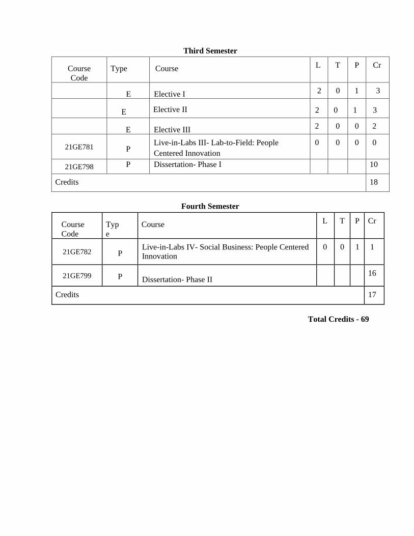
Third Semester
Course
Code
Type Course L T P Cr
E Elective I 2 0 1 3
E Elective II 2 0 1 3
E Elective III 2 0 0 2
21GE781
P Live-in-Labs III- Lab-to-Field: People
Centered Innovation
0 0 0 0
21GE798 P Dissertation- Phase I 10
Credits 18
Fourth Semester
Course
Code
Typ
e
Course L T P Cr
21GE782
P Live-in-Labs IV- Social Business: People Centered Innovation
0 0 1 1
21GE799 P
Dissertation- Phase II
16
Credits 17
Total Credits - 69
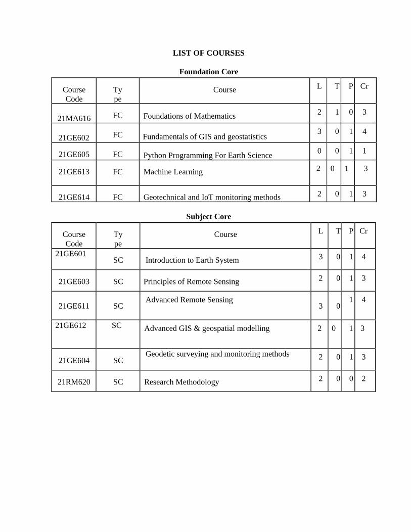
LIST OF COURSES
Foundation Core
Course
Code
Ty
pe
Course L T P Cr
21MA616 FC Foundations of Mathematics 2 1 0 3
21GE602 FC Fundamentals of GIS and geostatistics 3 0 1 4
21GE605 FC Python Programming For Earth Science 0 0 1 1
21GE613 FC Machine Learning 2 0 1 3
21GE614 FC Geotechnical and IoT monitoring methods 2 0 1 3
Subject Core
Course
Code
Ty
pe
Course L T P Cr
21GE601 SC Introduction to Earth System 3 0 1 4
21GE603 SC Principles of Remote Sensing 2 0 1 3
21GE611
SC Advanced Remote Sensing
3
0 1 4
21GE612 SC Advanced GIS & geospatial modelling 2 0 1 3
21GE604 SC Geodetic surveying and monitoring methods 2 0 1 3
21RM620 SC Research Methodology 2 0 0 2
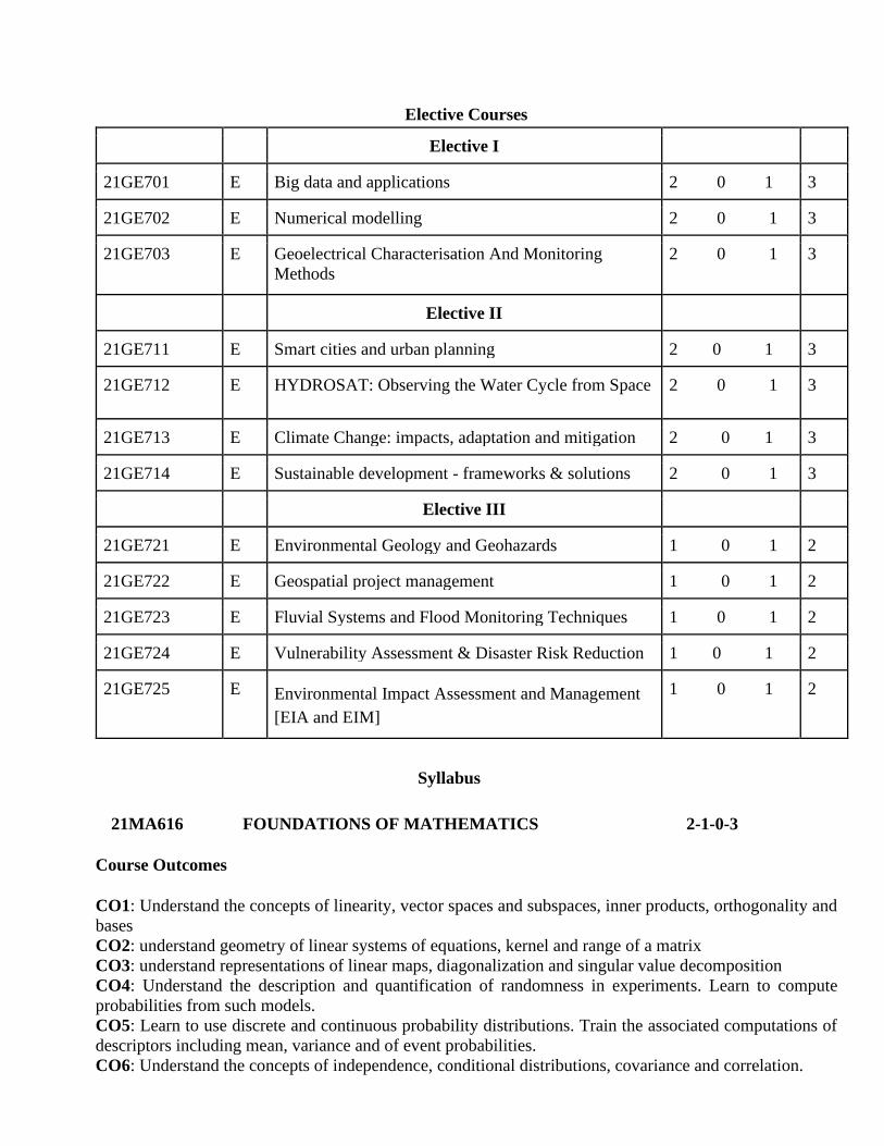
Elective Courses
Elective I
21GE701 E Big data and applications 2 0 1 3
21GE702 E Numerical modelling 2 0 1 3
21GE703 E Geoelectrical Characterisation And Monitoring
Methods
2 0 1 3
Elective II
21GE711 E Smart cities and urban planning 2 0 1 3
21GE712 E HYDROSAT: Observing the Water Cycle from Space 2 0 1 3
21GE713 E Climate Change: impacts, adaptation and mitigation 2 0 1 3
21GE714 E Sustainable development - frameworks & solutions 2 0 1 3
Elective III
21GE721 E Environmental Geology and Geohazards 1 0 1 2
21GE722 E Geospatial project management 1 0 1 2
21GE723 E Fluvial Systems and Flood Monitoring Techniques 1 0 1 2
21GE724 E Vulnerability Assessment & Disaster Risk Reduction 1 0 1 2
21GE725 E Environmental Impact Assessment and Management
[EIA and EIM]
1 0 1 2
Syllabus
21MA616 FOUNDATIONS OF MATHEMATICS 2-1-0-3
Course Outcomes
CO1: Understand the concepts of linearity, vector spaces and subspaces, inner products, orthogonality and
bases
CO2: understand geometry of linear systems of equations, kernel and range of a matrix
CO3: understand representations of linear maps, diagonalization and singular value decomposition
CO4: Understand the description and quantification of randomness in experiments. Learn to compute
probabilities from such models.
CO5: Learn to use discrete and continuous probability distributions. Train the associated computations of
descriptors including mean, variance and of event probabilities.
CO6: Understand the concepts of independence, conditional distributions, covariance and correlation.
Part I: Linear Algebra
Determinants- Row Reduction and Cofactor Expansions, Row picture, Column picture, Vector Spaces-
Euclidean space, General (real) Vector Spaces, Subspaces, Linear Independence, Dimension, Row,
Column and Null spaces.
Inner products: Norms, Orthogonal Bases and Gram-Schmidt Orthogonalization; Matrix Multiplication
Problems, Matrix Analysis, Gauss Elimination Technique, Diagonalization of a Matrix, Singular value
decomposition, Dimensionality Reduction, Principal Component Analysis.
Linear Transformations: Kernel and Range, Inverse Transformations, Matrices of Linear Transformations,
Change of Basis, Similarity; Orthogonalization and Least Squares, Eigenvalues and Eigenvectors,
Iterative methods for linear systems
Skills Acquired: Mathematical representation of physical systems in array & equations
TEXT BOOKS/REFERENCES:
1. Howard Anton, Chris Rorres, “Elementary Linear Algebra - Applications Version”, 11th, 2014
2. Rice, John A., “Mathematical Statistics and Data Analysis, 3rd Cengage Brook/Cole, 2007
Further References
5. Golub and Loan, "Matrix Computations", 3rd, John Hopkins University Press, 1996.
6. Carl. D. Meyer, "Matrix Analysis and Applied Linear Algebra", SIAM, 2001.
7. Gilbert Strang, "Introduction to Linear Algebra", 4th, Wellesley Cambridge Press, 2009.
21GE601 INTRODUCTION TO EARTH SYSTEM 3-0-1-4
Course Outcomes:
CO1 : Understand the concept of a coupled Land-Atmosphere-Ocean as a whole system.
CO2 : Explain basic Geology and identify Geomorphological and Geological phenomena
CO3 : Understanding of landscape evolution and environmental planning
CO4 : Describe the composition of atmosphere, Atmospheric parameters, dynamics and thermodynamics
CO5 : Summarize the fundamentals of Oceanography
CO6 : Outline the various aspects of climate change, biosphere and ecosystem components
Basic Geology and Geomorphology: Nature and scope of Geology; fundamental concepts -
stratigraphy and structures; recent trends in Geomorphology. Approaches to geomorphology-
static, dynamic, environmental and applied; Landforms: Endogenetic and Exogenetic. climatic and
tectonic factors and rejuvenation of landforms. Geodynamics: Introduction to Geodynamics and
Diastrophic movements – Epeirogenic and orogenic mountain building, Structural geology: Folds,
Faults, Joints and Unconformities. Earthquakes and Seismic zonation. Plate Tectonics, Continental
Drift, Concept of Isostasy. Types of weathering, soil formation/ profiles and mass wasting. Agents
of erosion and deposition. Fluvial systems and concepts of gradation, Sea level changes and coastal

evolution. Applied Geomorphology landscape development and environmental planning.
Atmosphere and Ocean: Ocean: Ocean currents; coastal oceanography; Sea Surface temperature
Atmosphere: atmospheric composition, structure; Pressure, temperature, humidity; vertical
structure of the atmosphere; Global wind systems. Land-Atmosphere interaction; Ocean-
atmosphere interaction; coastal erosion and deposition; Atmospheric Radiation: electromagnetic
radiations; Radiation laws; Earth’s heat budget; scattering; albedo; Hydrostatic equation;
hypsometric equation and sea level pressure; Convection, lapse rate, concept of air parcel;
atmospheric stability; saturation; lifting condensation level; clouds; Introduction to atmospheric
dynamics; equations of motion; atmospheric boundary layer. Tropical weather systems: Indian
monsoon system; El Nino; Tropical cyclones-genesis, structure and climatology: monsoon
depressions; other systems.
Concept of an ecosystem : understanding ecosystem, ecosystem degradation, resource utilization.
structure and functions of an ecosystem; producers, consumers and decomposers; energy and
matter flow in the ecosystem: water cycle, carbon cycle, oxygen cycle, nitrogen cycle, energy
cycle; food chains, food web and ecological pyramids; forest ecosystems; grassland ecosystems;
desert ecosystems; aquatic ecosystems
Climate change: Climate change history geological evidence; Greenhouse effect: Global CO2;
Stratospheric ozone; evidence for climate change; extreme weather events; climate change
mitigation; climate policy; disaster risk reduction; towards a climate resilient community.
TEXT BOOKS/REFERENCES:
1. Chandrashekhar, A. "Basics of Atmospheric Sciences." Basics of Atmospheric Science
280 (2010).
2. Huggett, R. (2016). Fundamentals of geomorphology. Routledge.
3. Masselink, G., & Hughes, M. G. (2014). An introduction to coastal processes and
geomorphology. Routledge.
4. Summerfield, M. A. (2014). Global geomorphology.
5. Allen, P. A., 1997, Earth surface processes: Oxford, U.K., Blackwell Science, 404 p. Benn,
D. I., and Evans, D. J. A., 1998, Glaciers and glaciation: New York, John Wiley and Sons, 734 p
6. Malone, T. (Ed.). (2016). Compendium of meteorology. Springer.
7. Wallace, J. M., & Hobbs, P. V. (2006). Atmospheric science: an introductory survey (Vol.
92). Elsevier.
8. Bharucha (2005), Textbook of environmental studies, Universities Press
9. Understanding the Earth 2017 7th Edition [eds. IG Gass et al.] ELBS edition
21GE602 FUNDAMENTALS OF GIS AND GEOSTATISTICS 3-0-1-4
Course Outcomes
CO1 : Understanding of spatial data, its types and how to handle it.
CO2: Map generation and its understanding in a GIS software (including open source software)
CO3 : Fundamentals of spatial statistics and introduction to R software
CO4 : Time series analysis in geospatial datasets
Cartography & GIS: Intro to Geographic Information Systems (GIS) and their applications; Vector
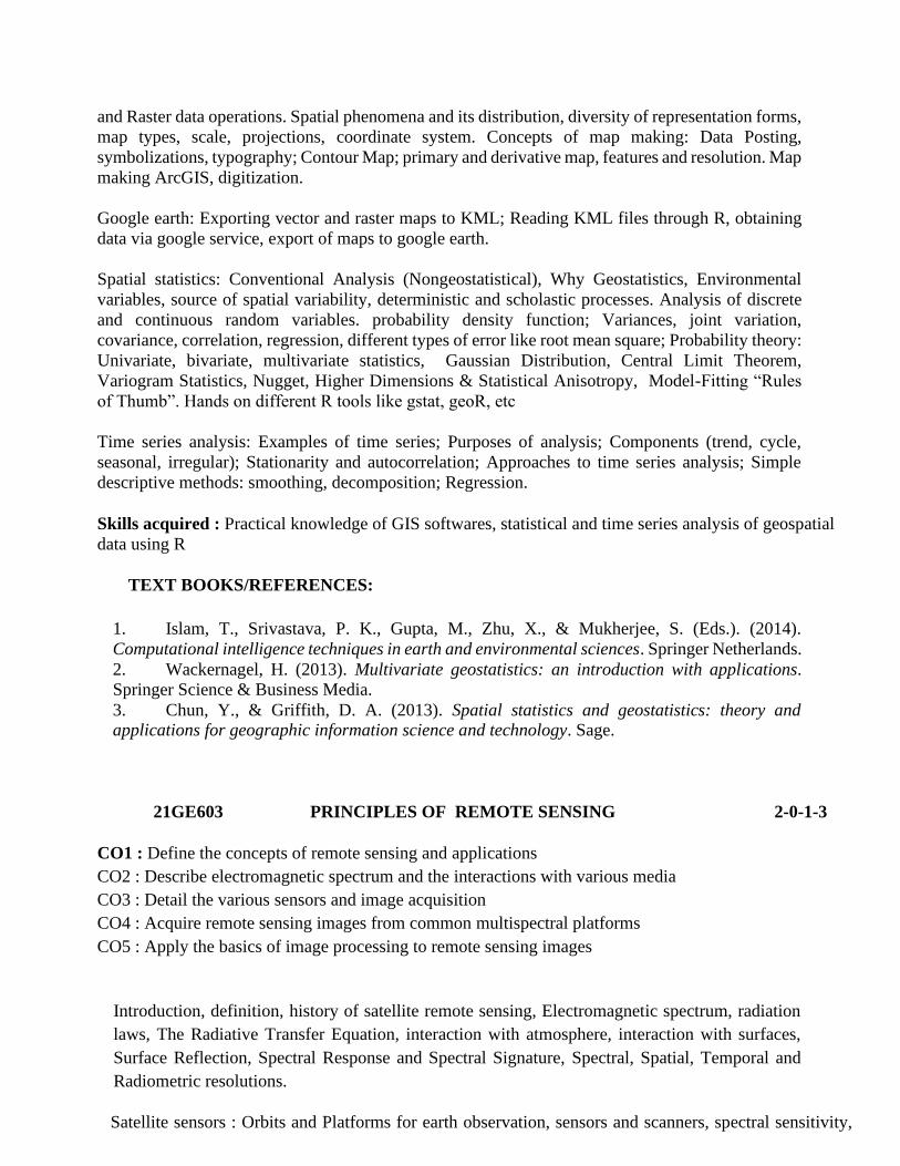
and Raster data operations. Spatial phenomena and its distribution, diversity of representation forms,
map types, scale, projections, coordinate system. Concepts of map making: Data Posting,
symbolizations, typography; Contour Map; primary and derivative map, features and resolution. Map
making ArcGIS, digitization.
Google earth: Exporting vector and raster maps to KML; Reading KML files through R, obtaining
data via google service, export of maps to google earth.
Spatial statistics: Conventional Analysis (Nongeostatistical), Why Geostatistics, Environmental
variables, source of spatial variability, deterministic and scholastic processes. Analysis of discrete
and continuous random variables. probability density function; Variances, joint variation,
covariance, correlation, regression, different types of error like root mean square; Probability theory:
Univariate, bivariate, multivariate statistics, Gaussian Distribution, Central Limit Theorem,
Variogram Statistics, Nugget, Higher Dimensions & Statistical Anisotropy, Model-Fitting “Rules
of Thumb”. Hands on different R tools like gstat, geoR, etc
Time series analysis: Examples of time series; Purposes of analysis; Components (trend, cycle,
seasonal, irregular); Stationarity and autocorrelation; Approaches to time series analysis; Simple
descriptive methods: smoothing, decomposition; Regression.
Skills acquired : Practical knowledge of GIS softwares, statistical and time series analysis of geospatial
data using R
TEXT BOOKS/REFERENCES:
1. Islam, T., Srivastava, P. K., Gupta, M., Zhu, X., & Mukherjee, S. (Eds.). (2014).
Computational intelligence techniques in earth and environmental sciences. Springer Netherlands.
2. Wackernagel, H. (2013). Multivariate geostatistics: an introduction with applications.
Springer Science & Business Media.
3. Chun, Y., & Griffith, D. A. (2013). Spatial statistics and geostatistics: theory and applications for geographic information science and technology. Sage.
21GE603 PRINCIPLES OF REMOTE SENSING 2-0-1-3
CO1 : Define the concepts of remote sensing and applications
CO2 : Describe electromagnetic spectrum and the interactions with various media
CO3 : Detail the various sensors and image acquisition
CO4 : Acquire remote sensing images from common multispectral platforms
CO5 : Apply the basics of image processing to remote sensing images
Introduction, definition, history of satellite remote sensing, Electromagnetic spectrum, radiation
laws, The Radiative Transfer Equation, interaction with atmosphere, interaction with surfaces,
Surface Reflection, Spectral Response and Spectral Signature, Spectral, Spatial, Temporal and
Radiometric resolutions.
Satellite sensors : Orbits and Platforms for earth observation, sensors and scanners, spectral sensitivity,
band combinations-optical imagery, stereo photogrammetry. Digital imagery : spectral sensitivity, digital
data formats, band combination - multispectral imagery, radiometric corrections. Elementary image
processing : histogram operations, filter operations, image fusion, geometric operations, visual image
interpretation.
Active and passive microwave remote sensing : basics of RADAR and LIDAR, radiometry,
spectrometers, image restorations and atmospheric corrections, Thermal imagery : basic theory,
blackbodies and emissivity, processing of thermal data.
Commonly used multi-spectral remote sensing satellite systems : LANDSAT, SPOT, ENVISAT,
RADARSAT, IRS, IKONOS, SENTINEL Family, RISAT, RESOURCESAT etc
Skills acquired : Acquire and perform basic processing of remote sensing images, understanding
of various satellite sensors and their applications
TEXT BOOKS/REFERENCES:
1. Barrett, E. C. (2013). Introduction to environmental remote sensing. Routledge.
2. Chuvieco, Emilio. (2016) Fundamentals of satellite remote sensing: An
environmental approach. CRC press.
3. Lillesand, T., Kiefer, R. W., & Chipman, J. (2015). Remote sensing and image
interpretation. John Wiley & Sons.
4. Campbell, J. B., & Wynne, R. H. (2011). Introduction to remote sensing. Guilford Press.
21GE604 GEODETIC SURVEYING AND MONITORING METHODS 2-0-1-3
Course Outcomes (CO)
CO1: Introduction and foundation of Geodetic survey
CO2: To learn technological enhancements in Geodetic monitoring
CO3: Introduction and application of modern Geodetic survey equipment: total station, DGPS,
EDM, Drones etc.
CO4 Application of satellite Geodetic survey : gravimetry and altimetry
Familiarization with high precision surveying instrument systems. Become capable of applying geodetic
theory in high precision monitoring networks.
Introduction to Geodesy: Basics of Geodesy, its Classification and scope of Geodesy for the Benefit of
Society.Georeferencing and Projection: Understanding coordinate system, Datum, Map Projection,
Georeferencing, and techniques of spatial data superposition.
Measurements Methods : Distance , angle measurements, errors and uncertainties and impact on designing
the survey plan, use of Compass, EDM, Ultrasonic Methods, VLBI, Global Positioning System (GPS-
DGPS) Monitoring and Improvements
Basic Surveying: Surveying principles, equipment, errors sources, and setting ground control points (GCP),
Topographical surveying using total station, GNSS and Space Exploration, Integrated Geodetic
Measurements.
Geometrical and Gravimetric observations: Satellite gravimetry from Gravity Recovery and Climate
Experiment (GRACE) and GRACE follow-on (GRACE-FO). Satellite altimetry: Concept of data
acquisition and correction, applications and limitations, hands on different missions like Jason series,
envisat, SARAL-altika, etc.
Exploratory data analysis: ground based radiometer data acquisition, sampling design, Developing skills
in data collection, processing, analysis and interpretation via advanced and complex calculations and
computer programming. DEM generation from contour data.
Drone: Data acquisition from drone camera, data correction and interpretation. Stereo Photogrammetry,
Concept of Orientation and Aerial Triangulation, Digital Terrain Modeling\Digital Elevation Model \Digital
Surface Model 3D Feature Extraction, 3D city modeling.
Case studies of smart city applications, disaster management etc
Skills acquired : Theoretical and practical knowledge of acquiring and processing data from surveying
equipments, GNSS, geometrical, gravimetric, radiometric and drone based observations
TEXT BOOKS/REFERENCES:
Geodesy
1. Ghilani, Charles D. Elementary Surveying : An Introduction to Geomatics . 15th ed. New York:
Pearson, 2018.
2. Deng, X. (2015). Geodesy–Introduction to Geodetic Datum and Geodetic Systems.
3. Smith, J. R. (1997). Introduction to geodesy: the history and concepts of modern geodesy (Vol. 1).
John Wiley & Sons.
4. Vanicek, P., & Krakiwsky, E. J. (2015). Geodesy: the concepts. Elsevier.
5. Wang, Jian-Guo (2009): Geodetic Surveys, Lecture Notes, Department of Earth and Space Science
and Engineering, York University, revised 2011.
6. Anderson, M.J., and E.M. Mikhail, (1998). Surveying: Theory and Practice. McGraw-Hill, (7th
Edition).
7. Vaníček P., and E. Krakiwsky (1986). Geodesy: The Concepts. North Holland, Amsterdam (2nd
Edition).
SUGGESTED REFERENCES
1. El-Rabbany, A. (2002). Introduction to GPS, the Global Positioning System. Artech House, Boston.
2. Kavanagh, B.F., (2003). Surveying Principles and Applications. Prentice Hall, New Jersey (6th
Edition).
3. Leick, A, (1995). GPS Satellite Surveying. John Wiley, New York (2nd Edition).
4. Ghilani, C.D. and Wolf, P.R. (2006), Adjustment Computations: - Spatial Data Analysis, John Wiley
& Sons (4th edition), 2006.
5. Mikhail, E.D., and G. Gracie, (1981), Analysis & Adjustment of Survey Measurements, Van
Nostrand Reinhold.
6. Wolf, P.R., and C.D. Ghilani, (2002). Elementary Surveying. An Introduction to Geomatics. Prentice
Hall, New Jersey (10th Edition).

21GE605 PYTHON PROGRAMMING FOR EARTH SCIENCE 0-0-1-1
Course Outcomes
CO1 : Understand the fundamentals of Python programming language
CO2 : Learn the concepts of object oriented programming in Python
CO3 : Execute Python scripts for simple data analysis
CO4 : Utilise data frames for data analysis
CO5 : Create simple visualisations and graphs for data analysis
Introduction to Python, variables, data types, objects and object oriented programming, classes, inheritance,
lists and indices, loops, conditional statements, functions, script files, loading and using modules
Numpy arrays , Data analysis using pandas, plotting using Matplotlib, programming with spatial data
Skills acquired : Basics of python programming
TEXT BOOKS/REFERENCES:
1. Downey, A. (2015). Think Python. " O'Reilly Media, Inc.".
2. McKinney, W. (2012). Python for data analysis: Data wrangling with Pandas, NumPy, and
IPython. O'Reilly Media, Inc.
3. https://www.earthdatascience.org/courses/intro-to-earth-data-science/
4. Lutz, M. (2013). Learning python: Powerful object-oriented programming. " O'Reilly Media.
21GE611 ADVANCED REMOTE SENSING 3-0-1-4
COURSE OUTCOMES:
On completion of this course, the student shall be able to
1. Understand concepts of Radar systems and its application
2. Gain knowledge in the principles of Lidar data and interpretation
3. Understand the various application domains of hyperspectral remote sensing
4. Gain exposure various image processing techniques
Image processing : Image registration – definition principle and procedure - Fundamental of image
recertification, interpolation- intensity interpolation- Radiometric & geometric correction of remotely
sensed data. Basic statistical concept in DIP and use of probability methods in DIP- Image enhancement
techniques - an overview-Contrast enhancement - linear and nonlinear, histogram equalisation and density
slicing Spatial filtering and edge enhancement, Multi image manipulation – addition, subtraction and band
rationing -Enhancement by using colours – advantages, types of colour enhancements
RADAR Techniques: SAR Interferometry (InSAR, DInSAR) and Polarimetry: [ fundamental concept,
methodology, processing, application], SAR Systems and Image Acquisition Modes, SAR data processing
and backscatter image generation, Advance techniques of SAR Remote Sensing, Application of SAR
imagery in the field of defence and security; Fundamentals of RADAR, SAR Interferometry, and SAR
imagery; Introduction to SAR sensors and platforms, SAR geometrical and radiometric effects,
enhancements of a SAR image, basic SAR imagery ordering, interpretation of SAR imagery, SAR
signatures, change detection using amplitude and interferometry coherence map, SAR interferometry
ordering, coherence maps, DEM generation, interferogram and displacement maps SAR interferometry
applications in the field of security and defence; Applications of RADAR -soil response-vegetation
response- water and ice response- urban area response
LiDAR: Measurements using LiDAR and its applications: temporal and spatial coverage, Impact of Errors,
Information extraction from LiDAR data, Principles of LiDAR, LiDAR sensors and platforms, LiDAR
data view, processing, and analysis, LiDAR applications: topographic mapping, vegetation
characterization, and 3-D modeling of urban infrastructure, Basic skills of LiDAR needed to leverage the
commercial LiDAR sources, Software packages (ArcGIS LAS Dataset; FUSION/LDV; PointVue LE;
LAStools) for LiDAR data displaying, processing, and analyzing. LIDAR data applications
Hyper-spectral Remote Sensing: Hyper-spectral Imaging: Hyper spectral concepts, data collection
systems, calibration techniques, data processing techniques; preprocessing, N-dimensional scatter-plots,
Special angle mapping, Spectral mixture analysis, Spectral Matching, Mixture tuned matched filtering,
Classification techniques, airborne and space-borne hyperspectral sensors, applications. High resolution
hyperspectral satellite systems: Sensors, orbit characteristics, description of satellite systems, data
processing aspects, applications.
Skills acquired : Theoretical and practical knowledge of acquiring and processing RADAR, LIDAR and
hyperspectral data.
REFERENCES:
1. Floyd.M.Handerson and Anthony, J.Lewis “Principles and applications of Imaging RADAR”,
Manual of Remote sensing, 3rd edition, vol.2, ASPRS, Jhumurley and sons, Inc, 1998.
2. Ian Faulconbridge, Radar Fundamentals, Argos Press, 2002.
3. Philippe Lacomme,Jean clande Marchais,Jean-Philippe Hardarge and Eric Normant, Air and
spaceborne radar systems - An introduction, Elsevier publications 2001.
4. Roger J Sullivan, Knovel, Radar foundations for Imaging and Advanced Concepts, SciTech
Pub, 2004.
5. Marcus Borengasser and William C., Hungate and Russel Watkins, “Hyper spectral Remote
sensing: principles and application” CRC, 2008
6. Pinliang Dong and QiChen., Lidar remote sensing and applications ISBN 9781138747241
Published December 12, 2017 by CRC Press220 Pages 40 Color & 143 B/W Illustrations
21GE612 ADVANCED GIS AND GEOSPATIAL MODELLING 2-0-1-3
Course Outcomes
CO1 : Exploring different geospatial data types and statistical methods
CO2: GIS techniques in GIS software and model builder (ArcGIS/Q-GIS)
CO3: Point pattern analysis and spatial interpolation
CO4: Geospatial multi-criteria decision making and site suitability analysis
CO5: Network analysis
Geospatial Analysis: foundations for analysis of continuous and discrete phenomena. GIS data
Models and visualization. Geodatabase and attribute table handling. Spatial Statistical Models and
GIS Model Builder. Analysis and modeling with map algebra.
Point Pattern Analysis. Neighborhood operations and buffers. Spatial interpolation and
approximation (gridding): Thessian polygon, TIN, Kriging, variogram calculation and
interpretation.
Raster distance calculation: cost surfaces, Euclidean and least cost path; Multi-criteria decision
making (MCDM). Application of MCDM in different sectors. Network model and spatial
optimization model. Site suitability modeling.
Contribution of geospatial tech in different industrial and govt projects. Legal and policy
aspects.Guest lectures: sharing of real time applications from invited talks
Note : software flexibility (ARCGIS/QGIS)
Skills acquired : Experience on working with geospatial data for societal benefit using GIS software
TEXT BOOKS/REFERENCES:
1. Reddy, GP Obi. "Spatial Data Management, Analysis, and Modeling in GIS: Principles and
Applications." Geospatial Technologies in Land Resources Mapping, Monitoring and
Management. Springer, Cham, 2018. 127-142.
2. Abdelbaki, Chérifa, et al. "Contribution of GIS and Hydraulic Modeling to the Management
of Water Distribution Network." Geospatial Challenges in the 21st Century. Springer, Cham,
2019. 125-150.
3. Kumar, Pavan, et al., eds. Applications and Challenges of Geospatial Technology: Potential
and Future Trends. Springer, 2018.
21GE614 GEOTECHNICAL AND IOT MONITORING METHODS 2-0-1-3
Course Outcomes (CO)
CO1: To provide an introduction to geotechnical engineering and soil mechanics
and an understanding of the scope of these subjects
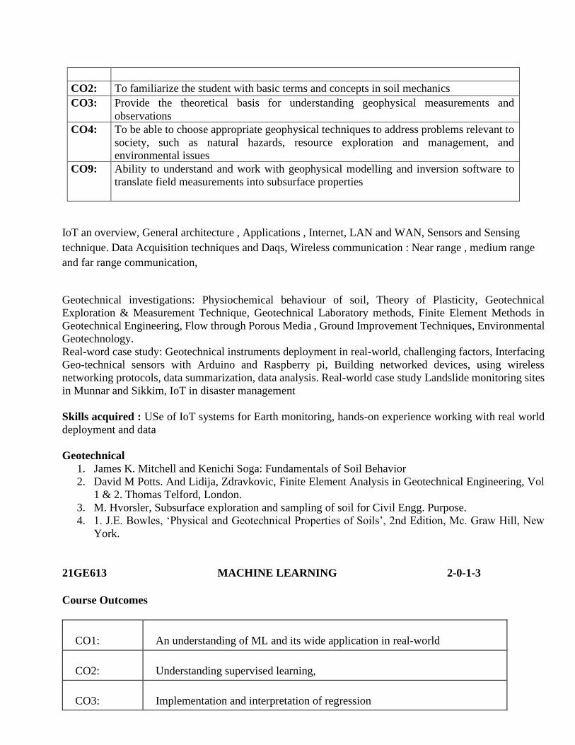
CO2: To familiarize the student with basic terms and concepts in soil mechanics
CO3: Provide the theoretical basis for understanding geophysical measurements and
observations
CO4: To be able to choose appropriate geophysical techniques to address problems relevant to
society, such as natural hazards, resource exploration and management, and
environmental issues
CO9: Ability to understand and work with geophysical modelling and inversion software to
translate field measurements into subsurface properties
IoT an overview, General architecture , Applications , Internet, LAN and WAN, Sensors and Sensing
technique. Data Acquisition techniques and Daqs, Wireless communication : Near range , medium range
and far range communication,
Geotechnical investigations: Physiochemical behaviour of soil, Theory of Plasticity, Geotechnical
Exploration & Measurement Technique, Geotechnical Laboratory methods, Finite Element Methods in
Geotechnical Engineering, Flow through Porous Media , Ground Improvement Techniques, Environmental
Geotechnology.
Real-word case study: Geotechnical instruments deployment in real-world, challenging factors, Interfacing
Geo-technical sensors with Arduino and Raspberry pi, Building networked devices, using wireless
networking protocols, data summarization, data analysis. Real-world case study Landslide monitoring sites
in Munnar and Sikkim, IoT in disaster management
Skills acquired : USe of IoT systems for Earth monitoring, hands-on experience working with real world
deployment and data
Geotechnical
1. James K. Mitchell and Kenichi Soga: Fundamentals of Soil Behavior
2. David M Potts. And Lidija, Zdravkovic, Finite Element Analysis in Geotechnical Engineering, Vol
1 & 2. Thomas Telford, London.
3. M. Hvorsler, Subsurface exploration and sampling of soil for Civil Engg. Purpose.
4. 1. J.E. Bowles, ‘Physical and Geotechnical Properties of Soils’, 2nd Edition, Mc. Graw Hill, New
York.
21GE613 MACHINE LEARNING 2-0-1-3
Course Outcomes
CO1: An understanding of ML and its wide application in real-world
CO2: Understanding supervised learning,
CO3: Implementation and interpretation of regression
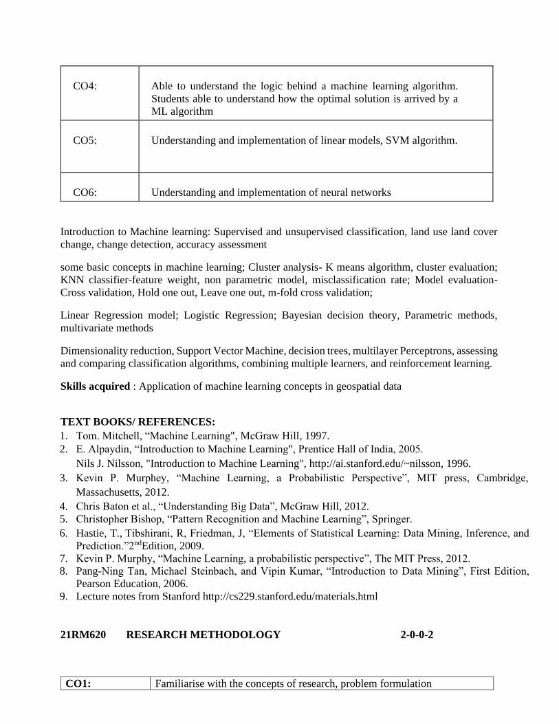
CO4: Able to understand the logic behind a machine learning algorithm.
Students able to understand how the optimal solution is arrived by a
ML algorithm
CO5: Understanding and implementation of linear models, SVM algorithm.
CO6: Understanding and implementation of neural networks
Introduction to Machine learning: Supervised and unsupervised classification, land use land cover
change, change detection, accuracy assessment
some basic concepts in machine learning; Cluster analysis- K means algorithm, cluster evaluation;
KNN classifier-feature weight, non parametric model, misclassification rate; Model evaluation-
Cross validation, Hold one out, Leave one out, m-fold cross validation;
Linear Regression model; Logistic Regression; Bayesian decision theory, Parametric methods,
multivariate methods
Dimensionality reduction, Support Vector Machine, decision trees, multilayer Perceptrons, assessing
and comparing classification algorithms, combining multiple learners, and reinforcement learning.
Skills acquired : Application of machine learning concepts in geospatial data
TEXT BOOKS/ REFERENCES: 1. Tom. Mitchell, “Machine Learning", McGraw Hill, 1997. 2. E. Alpaydin, “Introduction to Machine Learning", Prentice Hall of India, 2005.
Nils J. Nilsson, "Introduction to Machine Learning", http://ai.stanford.edu/~nilsson, 1996. 3. Kevin P. Murphey, “Machine Learning, a Probabilistic Perspective”, MIT press, Cambridge,
Massachusetts, 2012.
4. Chris Baton et al., “Understanding Big Data”, McGraw Hill, 2012.
5. Christopher Bishop, “Pattern Recognition and Machine Learning”, Springer.
6. Hastie, T., Tibshirani, R, Friedman, J, “Elements of Statistical Learning: Data Mining, Inference, and
Prediction.”2ndEdition, 2009.
7. Kevin P. Murphy, “Machine Learning, a probabilistic perspective”, The MIT Press, 2012.
8. Pang-Ning Tan, Michael Steinbach, and Vipin Kumar, “Introduction to Data Mining”, First Edition,
Pearson Education, 2006.
9. Lecture notes from Stanford http://cs229.stanford.edu/materials.html
21RM620 RESEARCH METHODOLOGY 2-0-0-2
CO1: Familiarise with the concepts of research, problem formulation
CO2: Learn how to conduct a critical review of research literature on a chosen
topic
CO3: Understand the concepts behind data analysis
CO4: Familiarise with the ethical aspects of research
CO5: Application of the tools in a practical problem
Unit I:
Meaning of Research, Types of Research, Research Process, Problem definition, Objectives of
Research,Research Questions, Research design, Approaches to Research, Quantitative vs.
Qualitative Approach,Understanding Theory, Building and Validating Theoretical Models,
Exploratory vs. ConfirmatoryResearch, Experimental vs Theoretical Research, Importance of
reasoning in research.
Unit II:
Problem Formulation, Understanding Modeling & Simulation, Conducting Literature
Review,Referencing, Information Sources, Information Retrieval, Role of libraries in Information
Retrieval,Tools for identifying literatures, Indexing and abstracting services, Citation indexes
Unit III:
Experimental Research: Cause effect relationship, Development of Hypothesis, Measurement
SystemsAnalysis, Error Propagation, Validity of experiments, Statistical Design of Experiments,
FieldExperiments, Data/Variable Types & Classification, Data collection, Numerical and
Graphical DataAnalysis: Sampling, Observation, Surveys, Inferential Statistics, and Interpretation
of Results
Unit IV:
Preparation of Dissertation and Research Papers, Tables and illustrations, Guidelines for writing
the abstract,introduction, methodology, results and discussion, conclusion sections of a
manuscript. References,Citation and listing system of documents
Unit V:Intellectual property rights (IPR) - patents-copyrights-Trademarks-Industrial design
geographical indication. Ethics of Research- Scientific Misconduct- Forms of Scientific
Misconduct.Plagiarism, Unscientific practices in thesis work, Ethics in science
TEXT BOOKS/ REFERENCES:
1. Bordens, K. S. and Abbott, B. B., “Research Design and Methods – A Process
Approach”, 8thEdition, McGraw-Hill, 2011
2. C. R. Kothari, “Research Methodology – Methods and Techniques”, 2nd Edition, New
Age International Publishers
3. Davis, M., Davis K., and Dunagan M., “Scientific Papers and Presentations”, 3rd
Edition, Elsevier Inc.
4. Michael P. Marder,“ Research Methods for Science”, Cambridge University Press, 2011
5. T. Ramappa, “Intellectual Property Rights Under WTO”, S. Chand, 2008
6. Robert P. Merges, Peter S. Menell, Mark A. Lemley, “Intellectual Property in
New Technological Age”. Aspen Law & Business; 6th Edition July 2012
Syllabus for Elective Courses
21GE702 NUMERICAL MODELLING 2-0-1-3
Course Outcomes
CO1 : Explain the importance of numerical modelling for studying Earth system
CO2 : Construct computer programs for solving nonlinear equations
CO3 : Solve first order Ordinary differential equation
CO4 : Understand the concepts of numerical integration and differentiation
CO5 : Know how the numerical schemes and grids influence the model
CO6 : Apply numerical methods to simulate heat conduction, advection and diffusion in simple systems
Introduction, modelling of dynamical systems, significant digits and errors, Numerical Methods:
Solution of NonLinear Equation, Bisection Method, Newton’s Method, Numerical Integration,
Trapezoidal Method, Simpson’s 1/3 & 3/8 rule , Curve Fitting, Construction of forward, backward
difference table, Interpolation, Solution of ordinary differential equations, stability, convergence,
accuracy, Runge-Kutta methods, Solution of partial differential equations, discretisation, finite
difference methods, Solution of Laplace and Poisson equations, Solution of heat conduction
equations and Solution of wave equations, introduction to finite element methods, Galerkin
method, shape functions and discretisation.
Modelling the components of Earth System, Expert lectures
Skills acquired : Working with numerical models for Earth system components
TEXT BOOKS/REFERENCES:
1. Samarskii, A. A., & Mikhailov, A. P. (2014).Principles of mathematical modelling:
Ideas, methods, examples. CRC Press.
2. Slingerland, Rudy, and Lee Kump. Mathematical Modeling of Earth's Dynamical
Systems: A Primer. Princeton University Press, 2011
3. ANDREW. ROOD GETTELMAN (RICHARD B.). DEMYSTIFYING
CLIMATE MODELS: A User's Guide to Earth System Models. SPRINGER,
2018.
4. Durran, Dale R. Numerical methods for wave equations in geophysical fluid
dynamics. Vol 32. Springer Science & Business Media, 2013.Hamming, Richard.
Numerical methods for scientists and engineers. Courier Corporation, 2012.
5. Chapra, Steven C., and Raymond P. Canale. Numerical methods for engineers.
Boston: McGraw-Hill Higher Education, 2010.
21GE703: Geoelectrical Characterisation And Monitoring Methods (BGS offered course)
Course Description
Electrical Resistivity Tomography (ERT) method: geophysical method applied to the
characterisation and monitoring of the near-surface. ERT surveys can be applied to the
geological, hydrological and engineering investigation of the subsurface in 2D or 3D. It allows the characterisation of e.g. landslides, karst landscapes, wetlands, earth dams, landfills, mine
tailings, archeological sites, etc. Applied as a monitoring tool, it provides critical information related to changes in moisture content or changes in temperature in the ground.
Learning Objectives:
1. Training in ERT field campaign planning
2. Learning techniques of ERT data acquisition and processing
3. Insights of ERT data interpretation through data from real world deployments
4. ERT surveys, lab experiment and time-lapse experiences
5. Establish a solid scientific foundation for the students in the field of Electrical Resistivity.
6. Develop a coherent understanding of ERT applications to several of the world's problems (such as Landslides,
ground water quality etc.) from a scientific perspective.
Skills acquired : experience in ERT measurement, data interpretation and applications
21GE701 BIG DATA AND APPLICATIONS 2-0-1-3
Introduction: Large databases and their evolution, Introduction to Data Science - Why Big Data?
- Problems solved by Data Science - Data Science Process - Exploratory Data Analytics. Data
Preparation: data munging - scraping - sampling - cleaning. Exploring and Analysis of Data -
descriptive and inferential statistics, sampling, experimental design, parametric and non-
parametric tests of difference, ordinary least squares regression, and general linear models; Data
storage and management in order to be able to access data - especially big data - quickly and
reliably during subsequent analysis - storage, search and retrieval systems for large scale structured
and unstructured information systems.
Data Analytics - Theory and Methods - Supervised learning, Linear/Logistic Regression, Decision
trees, Naïve Bayes, Unsupervised learning - K-means clustering - Association rules - Unstructured
Data Analytics - Technologies and tools - Text mining - Web mining. Data Communication with
Information Visualization - Effective Information Visualization - Visual Encoding - Perception of
Visual Cues - Data Scales - Visualizing Time Series Data - Visualizing through stories and
interpretable summaries.
Skills acquired : Ability to apply the concepts of big data analytics in practical applications
Learning Outcomes:
1. Introduction to Big data analysis
2. Statistical models
3. data storage and management
4. machine learning basics
5. time series data visualization
TEXT BOOKS/REFERENCES:
1. Wes McKinney, "Python for Data Analysis: Data Wrangling with Pandas, NumPy, and
IPython", First Edition, O'Reily Media, 2012.
2. Cathy O'Neil and Rachel Schutt, “Doing Data Science Straight Talk from the Frontline",
First Edition, O'Reily Media, 2013.
3. Chris Eaton, et al, “Understanding Big Data”, McGraw-Hill, 2012.
4. Henrique C. M. Andrade, BugraGedik and Deepak S. Turaga, "Fundamentals of Stream
Processing: Application Design, Systems and Analytics", Cambridge University Press, 2014.
21GE711 SMART CITIES AND URBAN PLANNING 2-0-1-3
Urbanization: Urban population; built up area measurements; introduction to Urban Geology and
Terrain evaluation. GIS based urban planning and design, challenges of urban planning. Growth
of smart cities and waste disposal management. Recycling and resource conservation. Urban heat
index. Agroforestry, Changing Cities by Designing New and Extending Them - Designing
Suburbs and Regions. Classifications of Towns and Cities in India. Assessment of urban
transformations. Urban growth modeling concepts: Introduction to conventional and new
generation models like cellular automata, markov random, agent based models and flow
dynamics.Time-Enabled Geospatial Analysis: Python Scripting: write specialized tools, set up
iterative models, and customize geoprocessing tools to fit a particular urban project objective.
Class Project: case studies
Skills acquired : Knowledge in using GIS techniques in city planning and development
Learning Outcomes:
1. concepts of urbanization and urban growth
2. GIS based Urban studies
3. Introduction to urban growth modeling
4. Models like cellular automata, markov random, agent based model
5. Python scripting examples for urban applications
TEXT BOOKS/REFERENCES:
1. Scholten, H. J., & Stillwell, J. (Eds.). (2013). Geographical information systems for
urban and regional planning (Vol. 17). Springer Science & Business Media.
2. Black, J. (2018). Urban transport planning: Theory and practice. Routledge.
3. deRoo, G. (2017). Integrating city planning and environmental improvement:
Practicable strategies for sustainable urban development.Routledge.
4. Foot, D. (2017).Operational urban models: an introduction. Routledge.
5. Peer reviewed journal papers
21GE712 HYDROSAT: Observing the Water Cycle from Space 2 0 1 3
Course Outcomes:
CO1 : Hydrological states from satellite observations: surface water, soil moisture and groundwater
CO2 :Hydrological cycle from satellite observations: precipitation, evapotranspiration and runoff.
CO3: Hands on GRACE gravity field data for hydrological mass variation studies
CO4: Hands on satellite remote sensing datasets for surface water level estimation
CO5: Automate the analysis of hydrological observation by integrating different datasets.
The course will educate on how to work with the state of the art satellite data which provides
important information on the status and spatio-temporal changes of water resources worldwide.
Different satellite data can be used to monitor the water cycle or hydrologic states of a region,
like optical remote sensing, microwave, gravimetry, altimetry. Hands-on in these satellite data
acquisition and data-analysis. Specifically, explore water balance equation with Gravity
Recovery and Climate Experiment (GRACE) gravity field data for hydrological mass variation
along with the combination of other sensors like the upcoming Surface Water Ocean
Topography (SWOT) mission. Integrated use of different satellite altimetry datasets like Jason
1 or 2, Envisat, Saral-Altika, etc for surface water level estimation. Different soil moisture
datasets like Soil Moisture and Ocean Salinity (SMOS), Soil Moisture Active Passive (SMAP)
etc, precipitation data like Tropical Rainfall Measuring (TRMM), Global Precipitation
Measurement (GPM), along with Clouds and the Earth’s Radiant Energy System (CERES) and
Moderate Resolution Imaging Spectroradiometer (MODIS) etc will be explored. Different
algorithms for quantifying the hydrological cycle components.
TEXT BOOKS/REFERENCES
1. Multiscale Hydrologic Remote Sensing, Perspectives and Applications Edited By Ni-Bin Chang,
Yang Hong, ISBN 9781138072572, Published November 22, 2017 by CRC Press
2. Hydrologic Remote Sensing: Capacity Building for Sustainability and Resilience, Yang Hong, Yu
Zhang, Sadiq Lbraham Khan 2016.
3. Remote Sensing of the Terrestrial Water Cycle, Venkataraman Lakshmi 2012, AGU
21GE713 CLIMATE CHANGE: IMPACTS, ADAPTATION AND MITIGATION. 2-0-1-3
Climate change mitigation: Relationships between greenhouse gas emissions and climate change;
the sources and sinks for GH gases at the global level; Policy instruments for emission reductions,
including carbon taxes, emissions trading schemes and offset projects. Mitigation and sustainable
development: how they fit together and the importance of co-benefits; International organizations
and governance structures, agreements and reduction targets.
Measuring climate change: global and local phenomena; Life Cycle Assessment (LCA) based
Industrial ecology techniques; Global Warming Potential (GWP) and other metrics;
Climate resilience: What is Community-Driven Climate Resilience Planning? Shifts in
Governance to Support Lasting Solutions; Characteristics of Community-Driven Climate
Resilience Planning; Defining the Field of Community-Driven Resilience Planning; Critical;
GUIDING PRINCIPLES Whole Systems Thinking; Planning Processes as Learning Processes;
Emerging opportunities.
Project on Climate change mitigation strategy/ Climate resilience strategy
Learning Outcomes:
1. Human impact of climate change
2. History of Climate change research
3. Measuring climate change
4. Impacts of adaptation, mitigation of climate change on community.
TEXT BOOKS/REFERENCES:
IPCC, 2014: Climate Change 2014: Synthesis Report. Contribution of Working Groups I, II and
III to the Fifth Assessment Report of the Intergovernmental Panel on Climate Change [Core
Writing Team, R.K. Pachauri and L.A. Meyer (eds.)]. IPCC, Geneva, Switzerland, 151 pp
IPCC, 2014: Climate-resilient pathways: adaptation, mitigation, and sustainable development.
chapter In: Climate Change (2014)
21GE714 SUSTAINABLE DEVELOPMENT-FRAMEWORKS AND SOLUTIONS 2-0-
1-3
Introduction to Sustainable Development: Glimpse into History and Current practices - Broad introduction
to SD - its importance, need, impact and implications; definition coined; evolution of SD perspectives
(MDGs AND SDGs) over the years; recent debates; 1987 Brundtland Commission and outcome; later UN
summits (Rio summit, etc.) and outcome. Ecosystem & Sustainability: Fundamentals of ecology - types of
ecosystems & interrelationships, factors influencing sustainability of ecosystems, ecosystem restoration -
developmental needs. Introduction to sustainability & its factors, requirements for sustainability: food
security and agriculture, renewable resources - water and energy, non-renewable resources, factors and
trade-offs, sustainability conflicts, a conceptual framework for linking sustainability and sustainable
development.
Dimensions to Sustainable Development - society, environment, culture and economy; current challenges
- natural, political, socio-economic imbalance; sustainable development initiatives and policies of various
countries : global, regional, national, local; needs of present and future generation - political, economic,
environmental.
Gauging Sustainable Development - Sustainability and development indicators and SDGs, UN’s outlook
of sustainable development and efforts, UN SDGs - structure, governance and partnerships; communities /
society: ensuring resilience and primary needs in society; biosphere: development within planetary
boundaries; strengthening institutions for sustainability; shaping a sustainable economy.
Frameworks of Sustainability - Analytical frameworks in sustainability studies, sustainability metrics:
criteria and indicators; the significance of quantitative and qualitative assessments of sustainability;
current metrics and limitations; metrics for mapping and measuring sustainable development; application
of the metrics in real scenarios
Critical Perspectives on Sustainable Development: Resource management and implications on sustainable
development, implications for valuation, risk assessment; integrated decision-making processes:
requirements of information, information flow, data analytics, learning from historical data, multicriteria
decisions, multi level decisions, participatory decisions ; translating impact chains to information flows -
impact of governance and policies
Case Studies & Projects on Rural Sustainable Development (Indian village perspectives) - Village
resources (broad perspectives); current challenges and thematic areas; village social hierarchy; village
economy; needs of present and future generation; conflicts - sustainability and rural culture & tradition;
road to achieving sustainable development goals - bridging conflicts and way forward
Text Books/Reference Materials
1. Franco, I.B. and Tracey, J. (2019), "Community capacity-building for sustainable development:
Effectively striving towards achieving local community sustainability targets", International
Journal of Sustainability in Higher Education, Vol. 20 No. 4, pp. 691-725
2. Our Common Journey: A Transition Toward Sustainability. National Academy Press, Washington
D.C. Soubbotina, T. P. 2004.
3. Elliott, Jennifer. 2012. An Introduction to Sustainable Development. 4th Ed. Routledge, London
4. Rogers, Peter P., Kazi F. Jalal, and John A. Boyd. "An introduction to sustainable development."
(2012).
5. Sachs, J. D. 2015. The Age of Sustainable Development. Columbia University Press, New York
21GE721 ENVIRONMENTAL GEOLOGY AND GEOHAZARDS 1-0-1-2
Fundamental Principles of Environmental Geology.Geofactor considerations for safe and
sustainable development. Soil forming processes, soil types, soil degradation and changing land
use pattern. Soil erosion and soil conservation Concepts of natural ecosystems on the Earth and
their mutual inter-relations and interactions (atmosphere, hydrosphere, lithosphere and biosphere).
Environmental changes due to influence of human-dominated environment overnature-dominated
system. Concept of Biodiversity and Geodiversity. Mobility of elements.Impact assessment of
water availability, quality and contamination of surface water and groundwater.Introduction to
medical geology.Atmosphere and air pollution.Soil contamination due to urbanization,
industrialization and mining.Basic tenets of environmental laws.Distribution, magnitude and
intensity of earthquakes. Geo-tectonic and seismic hazard assessment. Preparation of seismic
hazard maps.Impact of seismic hazards on long and short term environmental conditions.
Mechanism of landslides, causes of major floods, cyclones and storms. Deforestation and land
degradation. Dryland environments: Droughts and Desertification
Class projects: Study of seismic and flood prone areas in India, Evaluation of environmental
impact of air pollution, contaminated groundwater, landslides, deforestation, cultivation and
building construction in specified areas and affected societies.
Learning Outcomes:
1. Fundamental Principles of Environmental Geology
2. Weathering and Soil forming processes
3. Concepts of natural ecosystems on the Earth and their mutual inter-relations and
interactions
4. Air pollution and ground pollution.
5. Geohazards concepts and project work
TEXT BOOKS/REFERENCES:
Keller E A; Environmental Geology
K S Valdiya; Environmental Geology: Ecology, Resource and Hazard Management
Alan E Kehew: Geology for Engineers and Environmental Scientists
21GE723 FLUVIAL SYSTEMS AND FLOOD MONITORING TECHNIQUES 1-0-1-2
Hydraulics, Meteorology and Hydrology, Fluvial systems and river basin analysis
Introduction to Floods, Spatio-temporal distribution of floods, flood mitigation strategies,
Structural and non-structural approaches in flood mitigation, Approaches to the reduction of flood
impacts, Engineering solutions to flood control.
2D and 3D river flood modeling, Dam break modelling, flood risk maps. Flood Prediction Models
Real-Time Flood Monitoring Using Wireless Sensor Networks, Flood monitoring and warning:
case studies, Requirements for a Flood Monitoring System, monitoring Sensors, Design of the
Real-Time Flood Monitoring System
Learning outcome:
1. understanding the fluvial systems, hydromorphology
2. floods and flood dynamics, risk reduction strategiesFlood modeling premier
3. Monitoring system design for flood monitoring
TEXT BOOKS/REFERENCES:
1. Adams, T. E., & Pagano, T. C. (Eds.). (2016). Flood Forecasting: A Global Perspective.
Academic Press.
2. Costa, J. E., & O'Connor, J. E. (1995). Geomorphically effective floods. Natural and
anthropogenic influences in fluvial geomorphology, 89, 45-56.
3. peer reviewed literature.
21GE724 VULNERABILITY ASSESSMENT & DISASTER RISK REDUCTION
1-0-1-2
This course will enhance the learning experience by providing a scientific approach to disaster
risk reduction efforts and vulnerability assessment framework.
First quarter: understanding the vulnerability, definition, common approaches to vulnerability
assessment, methods and tools, Challenges
Second quarter: Students will be learning through some case studies, India and international.
Third quarter: Basic understanding of disasters, disaster risks, and disaster risk reduction.
Literature based module
Fourth quarter: Students will be doing a project based vulnerability assessment case study.
learning Outcomes:
1. Basics of Vulnerability assessment
2. concept of Disaster Risk reduction
3. Mapping vulnerability
4. Case studies to understand the strategic disaster risk reduction
TEXT BOOKS/REFERENCES:
GIZ, 2014: A Framework for Climate Change Vulnerability Assessments, Published by Deutsche
GesellschaftfürInternationaleZusammenarbeit (GIZ) GmbH, India Project on Climate Change
Adaptation in Rural Areas of India (CCA RAI
UNDP, 2010: Mapping climate change
vulnerability,http://www.adaptationcommunity.net/?wpfb_dl=58

21GE725 ENVIRONMENTAL IMPACT ASSESSMENT AND MANAGEMENT
1-0-1-2
The course has been designed to do mini projects with Industries and learn directly from Industry
experts the application of Remote Sensing and GIS in Environmental Impact Assessment (EIA)
studies including Environmental Clearance, Ambient Air Quality Monitoring, Analysis, Air
Pollution Modelling, Dispersion of Stack and Fugitive Emissions, Water Quality, Noise and
Vibration, Soil Quality, Fertility Status and Microbiological Quality in soil and Soil Erosion, Solid
& Hazardous Wastes – Characterization, Classification, TCLP, Socio-Economic Aspects, Risk
Assessment and Hazard Management,
Learning Outcomes:
1. Experience in environmental impact assessment
TEXT BOOKS/REFERENCES:
Peer reviewed journal papers
21GE681 LIVE-IN-LABS I: PARTICIPATORY DESIGN AND MODELLING
0-0-0-0
AMRITA University has established live-in-labs at 100+ locations, mostly in rural areas spread
across the length and breadth of India. Live-in-Labs© is an opportunity for students to live in a
village environment so they can study problems first-hand in water, health, education, etc. and
work together to devise solutions. Live-In-Labs will provide an experiential learning opportunity
where each student can come and spend for 2 weeks to a semester in one of the live in labs based
on the area. They will become part of the interdisciplinary team of students and faculty drawn from
across the disciplines from all participating universities. The live-in- labs have varied focus areas
such as energy, water, healthcare, education, waste management, ICT for billion, skill building
etc.
During this process the students will share village life and observe and understand problems encompassing health and hygiene, energy, water, waste, environment, etc., touching the villagers’ lives, and define projects that seek to address these problems, devise solutions, implement, test and eventually demonstrate innovative solutions. One definitive achievement is that they will receive a deeper understanding of challenges faced by emerging developing countries. This gives the wonderful opportunity since emerging countries have the largest opportunity for new ideas, innovative solutions etc.

Identify the problem, Proposal Writing -Proposal Format, Budget Estimation, Proposal Drafts,
Proposal re-evaluation, Final Proposal Draft. Advanced Human Centered Design
21GE781 LIVE-IN-LABS III: LAB-TO-FIELD: PEOPLE CENTERED INNOVATION
0-0-0-0
Sustainable Approach to Product Designing, Project Management, Planning, Implementing
Evaluation of Implementation, Plan with Domain Experts, Design Optimization
21GE782 LIVE-IN-LABS IV: SOCIAL BUSINESS: PEOPLE CENTERED
INNOVATION 0-0-1-1
Prototype Development & Evaluation- Model Building, Training on Relevant Simulation
Software, Software Simulation of Prototype Iteration (Incorporating HCD)’ Real Time Prototype
Development, Prototype Presentation. Prototype Review. Evaluating Implementation
Challenges-Space, Budget, Feasibility, External Factors.
Field Implementation, Generating Community Awareness, Research Paper Writing-Structure,
Writing Skills, Data Compilation, Deliverables