Embed Size (px)
Citation preview

Open Journal of Geology, 2012, 2, 14-24 http://dx.doi.org/10.4236/ojg.2012.21002 Published Online January 2012 (http://www.SciRP.org/journal/ojg)
Multi-Scale Organization of the Doumbouo-Fokoué Bauxites Ore Deposits (West Cameroon): Implication to
the Landscape Lowering
Mathieu Nouazi Momo1, Paul Tematio1*, Martin Yemefack2 1Department of Earth sciences, University of Dschang, Dschang, Cameroon
2Institut de Recherche Agronomique pour le Développement (IRAD), Yaoundé, Cameroun Email: *[email protected]
Received September 14, 2011; revised October 28, 2011; accepted December 3, 2011
ABSTRACT
Landscape distribution, macroscopic, microscopic, mineral and geochemical characterizations were conducted on the Doumbouo-Fokoué bauxite ore deposit in order to estimate bauxites potential and its implication to general lowering of the relief. Fourteen bauxitic plateaus covering a surface area of 5.7 km2 were identified. Bauxitic pedons show deep weathered profiles (10.0 - 12.0 m) with thick bauxitic mantle (4.0 - 8.0 m). Saprolite and pisolith bauxitic facies own high aluminium (47.5% - 49.5% Al2O3), relatively low iron (20.0% - 22.0% Fe2O3) and low silica contents (1.8% - 7.6% SiO2). Gibbsite is the dominant mineral (49% - 68% of minerals detected by X-ray); meanwhile hematite, goethite and kaolinite occur in small amounts. Bauxitization corresponds to intense allitization with abundant accumulation of gibbsite and development of lateritic iron bearing ortho-bauxites. Bauxite ores yielded bauxite reserves of 9.2 million tons. They occur as old and residual bauxitic mantles representing remnants of the Miocene residual lateritic deposits in West Cameroon referring to the African surface of Valeton [1]. Its mean altitude (1532 - 1590 m als) below the African surface reveals general lowering of the relief. Keywords: Bauxitic Plateaus; Saprolite Facies; Pisolith Facies; Relief Lowering; West Cameroon
1. Introduction
Bauxites are residual (lateritic bauxites) or sedimentary (karsts bauxites) rocks with more than 40% of Al2O3 and less than 8% of SiO2 [2] known as the main provider of aluminium. World bauxite resources are estimated around 75 billion tons [3], mainly in Africa (33%), Oce- ania (24%), South America and the Caribbean (22%), and Asia (15%). In West and Central Africa, lateritic bauxites are widespread and were developed especially in Guinea, Mali, Burkina-Faso, Ivory-Cost, Ghana, Nige- ria and Cameroon where more than 60 ores deposits are now inventoried [4].
In Cameroon, works on laterites in general, and lat- eritic bauxites in particular, started at the b eginning of the 20th century [5-11]. The majority of these studies were focussed on the characterization and the evaluation of the well known bauxites ores deposits in Minim- Martap and Ngaoundal-Ngaoundouro in the Adamaoua region and Fongo-Tongo and Bagam in the West region. They noted that Cameroon has the 6th world bauxite re- serves with approximately 1.5 billion tons. This amount
seems to be underestimated since there still be many non explored bauxitic indices in Cameroon as indicated by the SABAP exploration licence [7] and the recent geo- logical map of Cameroon [12]. The Doumbouo-Fokoué area contains one of these non explored bauxitic indices of Cameroon. The main objective of this study is to characterize the bauxitic facies of Doumbouo-Fokoué at different scales in order (i) to estimate the bauxites po- tential in this area and (ii) to correlate bauxites landscape distribution and evolution in this region with the general lowering of the relief in the West Cameroon Highlands. Results may contribute to increase the Cameroon bauxite reserves, examine in detail bauxitization process in the West Cameroon Highlands and correlate these bauxite ore deposits to the well known bauxites ore deposits in Cameroon and Africa.
2. Materials and Methods
2.1. The Site Setting
The Doumbouo-Fokoué region is located between longi- tudes 10˚05' and 10˚08' East and latitudes 5˚21' and 5°27’ North (Figure 1). Morphologically, it belongs to *Corresponding author.
Copyright © 2012 SciRes. OJG

M. N. MOMO ET AL. 15
Figure 1. Geological map and localization of Doumbouo- Fokoué region. the Bamiléké plateau (small insert in Figure 1) which corresponds to the south-western part of the West Cam-eroon Highlands with mean altitude 1400 - 1600 m asl. Very elongated interfluves with convex slopes are the dominant features in this region.
The Doumbouo-Fokoué region is deeply dissected by a dense hydrographic network which belongs to the Mé-noua watershed. It is under sub-equatorial climate of high altitude characterized by a long rainy season from March to October and short dry season from November to February. The mean annual rainfall is 1755 mm and the mean annual temperature is 20˚C.
From the geological point of view, the Doumbouo- Fokoué region belongs to the Cameroon volcanic line (CVL) [13] that crosses the western part of the Cameroon territory. It includes Cenozoic volcanic complexes over-lying on the Neo-proterozoic panafrican granito- gneissic units (Figure 1) [14]. In this region, the bauxite ores de-posits are developed exclusively from the Miocene aphy-ric or porphyric basalts [15]. They are composed pre-dominantly of laths of plagioclase (An46-72), coarse to fine grains of forsterite (Fo66-87), augite and diopside. Fe-Ti oxides occur as accessory minerals and Cr-Fe spinels as inclusions in forsterite. The groundmass con-sists of microlites of plagioclase and very fine interstitial grains of augite and diopside. The mean chemical com-position of these basalts is as follow: 15.9% of Al2O3, 13.5% of Fe2O3 and 44.6% of SiO2 [15] (cf. Table 3).
2.2. Analysis Methods
The study of the Doumbouo-Fokoué bauxite indices were
refers to the bauxite reserves m
il morphological de
microscopic, mineral and ch
oscopic analysis, non disturbed baux-iti
s were determined using X-ray diffraction (X
ts determination was performed using X
2.3. Calculation Methods
ents in bauxitic facies was
conducted at four different scales: landscape, pedons, thin section and sample.
The landscape study apping. It was based on preliminary works which con-
sisted at drawing and overlapping geological and mor-phological maps of the Doumbouo-Fokoué region using GIS (geographic information systems), with the resul-tants detailed geomorphologic map of the study area. Cartography of the bauxitic mantles was based on data collected during field works. Data correspond to bauxitic samples and their sampling sites coordinates which were afterwards projected onto the geomorphologic map using GIS to demarcate the bauxitic plateaus.
Pedons study is based on the field soscription method [16]. It was performed on road cuts,
quarries and pits. After what, bauxitic samples were col-lected for laboratory analyses.
Laboratory analyses concernemical analysis. Concerning micrc samples were hardened using epoxy resin, sharpened
and polished to obtain thin sections for microscope de-scription.
MineralRD) and thermo-gravimetric analysis (TGA). X-ray
diffraction was performed on 0.2 mm bauxitic powder using BRUKER diffract-meter according to the follow-ing conditions: copper anode (Cu-Kα), wavelength, λ: 1.5418 Å, scanning speed: 0.002°/s, scan range: 5° - 70°, drive axis 2θ. Thermo-gravimetric analysis consists in the evaluation of the weight loss of bauxitic powder dur-ing an increasing temperature (up to 900˚C). Minerals were identified and their relative abundance calculated using percentage of weight loss in a defined interval of temperature [17].
Chemical elemen-ray fluorescence on bauxitic powder crushed and
sieved into 0.2 mm. 300 mg of bauxitic powder were fused with 900 mg of lithium meta-borate (LiBO2) dur-ing 1h at 980˚C, and dissolved into 1.55 M of nitric acid. Chemical elements are quantified using ICP-AE spec-trometry for major elements and FI-ICP-M spectrometry for trace elements.
Enrichment-depletion of elemassessed using enrichment factors (EF). EF which is the ratio between the content of an element in any given bauxitic facies and that of the parent rock has been cal-culated using the relation: EF(X) = (Xi/Ri)/(Xs/Rs) [18]. In this relation Xi and Ri are the concentrations of the element of interest and immobile element (Ti) and Xs and Rs are the concentrations of the same elements in the
Copyright © 2012 SciRes. OJG

M. N. MOMO ET AL.
Copyright © 2012 SciRes. OJG
16
serves were also calculated using the fol-lo
3. Results
pe Distribution of Bauxitic Mantles
Fou been identified in Doum-
ince spreads out north of th
parent rock. Bauxite rewing formula: M = S × H × Da, where S is the total
bauxitic plateaus surface, H the mean thickness of baux-itic mantles and Da the bulk densities of the bauxitic facies.
3.1. Landscain Doumbouo-Fokoué
rteen bauxitic plateaus havebouo-Fokoué (Figure 2). All are made up of thick baux-itic mantles stretching out for kilometers at the summit and upper slopes of interfluves. They have been subdi-vided into two main bauxitic provinces: the Doumbouo and Fokoué bauxitic provinces.
The Doumbouo bauxitic prove locality and covers about three quarters of the area. In
this area, the bauxitic mantles cover a surface area of 5.1 km2, which represents about 89% of the bauxitic surface. It is thus the most abundant bauxite ores deposits in
Doumbouo-Fokoué. It consists of ten bauxitic plateaus called bowal that are organized into large interfluves with summit capped with bauxitic mantles and sur-rounded by steep slopes. They are thus characteristic of regions with contrasted climate. They are: Tsingla, Sa’a, Ngwa, Letagli, Doumbouo, Letet1, Letet2, Tougong, Honto and Meka plateaus. The Tsingla plateau shows a forked bauxitic mantle belt of about 2.5 km long (Figure 2). The Sa’a plateau consists of a branching bauxitic mantle with about 3.5 km long. The Ngwa plateau corre-sponds to a small bauxitic mantle strip (less than 1km long) near the Sa’a plateau. The Doumbouo plateau shows a bauxitic mantle belt with more than 4 km long in the NE area. The Letet1, Letet2 and Letagli plateaus oc-cur in the centre of the area and consist of pockets of bauxitic mantles not exceeding 1km wide. The Honto, Tougong and Meka plateaus correspond to the bauxitic mantle belts stretching out on 3 km, 1.5 km and 2 km respectively.
The Fokoué province is located in the southern part of the region and covers only a surface area of 0.6 km2 (Fig- ure 2). It is thus the least abundant bauxite ores deposits
Figure 2. Landscape distribution of bauxitic mantles in Doumbou-Fokoué.

M. N. MOMO ET AL. 17
this region. It is made bouo-Fokoué
m-
in up of four bauxitic plateaus also 3.2. Bauxitic Pedons in Doumorganized into bowal. They are: Mintso1, Mintso2, Mintso3 and Toufem plateaus. The Mintso1 and Mintso2 plateaus consist of pockets of bauxitic mantles not ex-ceeding 1km wide. The Mintso3 plateau is a V-shape bauxitic mantle with 1.5 km long. The Toufem plateau shows a bauxitic mantle belt with 1.5 km long.
Eight (8) bauxitic pedons were selected in Doubouo-Fokoué for morphological description (Figure 3). They are PZ1 and PZ2 pedons from the Tsingla bauxitic plateau; PS1, PS2 and PS3 pedons from the Sa’a bauxitic plateau; PD1 and PD2 pedons from the Doumbouo
Figure 3. Bauxitic pedons in doumbouo-fokoué.
Copyright © 2012 SciRes. OJG

M. N. MOMO ET AL. 18
auxitic plateau; and PF pedon from
ic pedons are located on
3.3. Bauxitic Facies in Doumbouo-Fokoué
m-
were characterized on macro-sc
s are summarized below.
d (10R4/6 to
porphyric s-matrix with both cl
s. But, the st
gibbsite and hematite (T
b the Mintso3 bauxitic view. The main resultplateau. Macroscopic organization and morphological characteristics of these bauxitic pedons are presented in Figure 3 and Table 1 respectively.
In Doumbouo-Fokoué, all bauxit slightly sloped crests (1% - 2%), between 1532 and
1590 m asl. They correspond to deep weathered soil pro-files (10.0 to 12.0 m thick and more) with very thick bauxitic B horizon (4.0 to 8.0 m) lying over a saprolite C horizon (Figure 3). The uppermost and very thick baux-itic B horizon corresponds to the bauxitic mantle and is subdivided into B11, B12, B13 and B14 sub-horizons. The B11 sub-horizon varies from 70 to 240 cm thick and is made up of bauxitic nodules and fragments embedded into a loose fine earth. The loose fine earth is dark red (2.5YR3/6), clayey sand, fragile, fine granular and friable. The bauxitic nodules and fragments represent 40% to 45% in volume of the sub-horizon. They are made up of red (10R4/6), very hard and more or less differentiated bauxitic matrix. The B12 sub-horizon has 200 to 650 cm thick. It is a continuous bauxitic duricrusts consisting of non differentiated, very hard and red (10R4/6) bauxitic matrix interrupted with yellow red (5YR4/8) and fairly hard streaks. Its lower boundary is distinct and irregular when lying on B13 sub-horizon, diffuse and regular on the contrary when lying on the saprolite C horizon. The B13 sub-horizon is poorly represented (only in PZ1 and PS2 bauxitic pedons) (Figure 3 and Table 1), thin (less than 200 cm) and made up of discontinuous bauxitic frag-ments embedded into fine earth. The fine earth is clayey, pale red (2.5YR4/8), fragile, coarse granular and firm. The bauxitic fragments do not exceed 30% in volume. They show yellow red (7.5YR6/6), fairly hard and non differentiated bauxitic matrix. The B14 sub-horizon is also poorly represented (only in PF pedon) (Figure 3 and Table 1). It always lies over the B12 sub-horizon when exists and corresponds to a 400cm thick and continuous bauxitic duricrusts made up of very hard, dark red (2.5YR3/6) and interstitial bauxitic matrix surrounding numerous yellow red (7.5YR6/8) bauxitic nodules.
Two main bauxitic facies were identified in Doubouo-Fokoué: the saprolite and the pisolith bauxitic fa-cies. The saprolite bauxitic facies is the most abundant bauxitic facies in Doumbouo-Fokoué. It is observed in all bauxitic pedons where it corresponds to the bauxitic duricrusts in B11, B12 and B13 sub-horizons (Figure 3 and Table 1). The pisolith bauxitic facies is the least abun-dant and corresponds to the continuous bauxitic duri- crusts in B14 sub-horizon.
The two bauxitic faciesopic, microscopic, mineral and geochemical point of
Macroscopically, the saprolite bauxitic facies exhibits continuous, very hard and dark red to yellow re
7.5YR6/8) bauxitic matrix scattered by numerous mi-crometric cavities and white grey punctuations (Figure 4(a)). The pisolith bauxitic facies is made up of intersti-tial bauxitic matrix surrounding more or less differenti-ated bauxitic nodules (Figure 4(b)). The interstitial bauxitic matrix is non differentiated, continuous, very hard, dark reddish brown to yellow red (2.5YR3/6; 7.5YR6/6), and contains micrometric white grey spots like in the saprolite bauxitic facies. The bauxitic nodules represent more than 35% in volume of the pisolith baux-itic facies. They display non differentiated, very hard and pale red to dark reddish brown (5YR6/8; 2.5YR3/6) in-ternal bauxitic matrix rimmed by dark red (2.5YR3/2) and differentiated cortex.
Optic microscopy reveals that the saprolite bauxitic facies is a reddish brown
ay- and crystal-rich plasmas (Figure 4(c)). The clay-rich plasma has insepic and plasmic fabric and corresponds to a brown red ferruginous matrix dissected by a network of micro-cracks. Locally, this plasma is superimposed on the crystal-rich plasma. The crystal-rich plasma has a crystallic b-fabric with whitish grey well developed crystals of gibbsite infilling micro-cracks (Figure 4(c)) or present as individual domains under the clay-rich plasma. This s-matrix is very porous, with packing and planar voids. The pedic features refer to the micro-particles with undulic to isotic b-fabric and the well developed banded cutans with alternate layers of ferrans and gibbsitans. In the pisolith bauxitic facies, two bauxitic domains were identified: the interstitial bauxitic matrix and the bauxitic nodules (Figure 4(d)). The interstitial bauxitic matrix represents less than 5% in volume. It shows the same microscopic organization like in the saprolite bauxitic facies, with porphyric and very porous s-matrix. The bauxitic nodules are very abundant (around 45% in vol-ume) and have spherical to sub-spherical shape, with mean diameter varying from 1 mm to 1.5 cm.
Their internal matrix also shows the same microscopic organization like in the saprolite bauxitic facie
riking features of these bauxitic nodules remain the presence of continuous, well differentiated, dark red and thin (0.08 to 0.125 mm) bauxitic cortex (Figure 4(d)). They are thus bauxitic pisoliths.
From a mineral point of view, the saprolite bauxitic facies contains predominantly
able 2). Gibbsite is the most abundant mineral, and represents 68.1% of minerals detected by X-ray. In XRD diagram (Figure 5), its major peak at 4.84 Å (not shown) suggests a well crystallized mineral. Hematite is also significant and represents 31.9% of minerals detected by X-ray.
Copyright © 2012 SciRes. OJG

M. N. MOMO ET AL. 19
Table 1. Morphological cha ristics orac f bauxitic pedons.
Pedon Horizon Depth
Phases wer
bRock fragments
(Siz )
te
(cm) Color Hardness
Textural Structure Consistence
Loclass oundary e and volumetric %
fe 2 i.5YR3/6 fragile cs f ne granular friable B11 0
vdisti lar
B12 240 - 480 10R /8
firm distinct and irregular
B13 480 - 680 fr d
differentiateddeffuse and regular
PZ1
C1 >680
fine r friable 100
vabrupt and regular
B12 100 - 740 10R /8 deffuse and regular PZ2
fine r friable
200 v
abrupt and regular
B12 200 - 400 10R /8 distinct and regular
5 to 20 cm - 5%
PS1
2. 3/6 fine ular
- 70 v
abrupt and regular
B12 70 - 420 10R /8 distinct and irregular
firm B13 420 - 620
fr ddifferentiated
deffuse and regular
C1 620 - 850 distinct and irregular < 25 cmm - 5%
PS2
2.5YR3/6 fragile fine g ular friable
150 v
abrupt and regular
B12 150 - 400 10R /8 distinct and regular
10 - 15 cm 3%
PS3
fe 2.5YR3/6 fragile cs fine
gr Very Friable
B11 0 - 150 v
differentiated
abrupt and regular
B12 150 - 800 10R /8 distinct and regular
PD1
fine r Fr
120 v
abrupt and regular
B12 120 - 620 10R /8 distinct and regular PD2
2.5YR3/6,7.5YR6/8 v deffuse and regular
- 240 dc 10R4/6 ery hard -
non differentiated
- nct and regu
dc 4/6.5YR4 very hard - non
differentiated-
fe 2.5YR4/8 fragile c corese
granular non
dc 7.5YR6/6 irly har - -
ws 10YR7/2 fragile c massive -
2.5YR3/6
fragile granulafe cs
B11 0 -dc 10R4/6 ery hard -
non differentiated
-
dc 4/6.5YR4 very hard - non
differentiated-
C1 >740 ws 10YR7/2 fragile c massive
-
2.5YR3/6
fragilefe cs granula B11 0 -
dc 10R4/6 ery hard - non
differentiated-
dc 4/6.5YR4 very hard - non
differentiated-
C1 400 - 1150 ws 10YR7/2 fragile c massive -
- distinct and irregular , 2% R >1150
- -
-
- -
fe 5YR fragile cs gran friable
B11 0 dc 10R4/6 ery hard -
non differentiated
-
dc 4/6.5YR4 very hard - non
differentiated-
fe 2.5YR4/8 fragile c corese
granular non
dc 7.5YR6/6 irly har - -
ws 10YR7/2 fragile c massive - ,2% R >850 - -
-
- -
-
fe cs ran
B11 0 -dc 10R4/6 ery hard -
non differentiated
-
dc 4/6.5YR4 very hard - non
differentiated-
C1 400 - 1230 ws 10YR7/2 fragile c massive -
- abrupt and irregular , 2% -R >1230 - - - - -
anularnon
dc 10R4/6 ery hard - -
dc 4/6.5YR4 very hard - non
differentiated-
C1 >800 ws 10YR7/2 fragile c massive
-
2.5YR3/6
fragilefe cs granula iable B11 0 -
dc 10R4/6 ery hard - non
differentiated-
dc 4/6.5YR4 very hard - non
differentiated-
C1 >620 ws 10YR7/2 fragile c massive -
e y hard
pisolithic PF B14 0 - 400 dc r - - Phases: fe, fine earth; dc, duricrust; ws, weathered saprolite. Textural class: c, clay; cs, clay sand.
Copyright © 2012 SciRes. OJG
M. N. MOMO ET AL. 20
2 cm 2 cm
(a) (b)
0.5mm
Fe
Fe
0.5mm
PiPi
Gi
(c) (d)
Figure 4. Macroscopic an oscopic organization o bauxitic fac us matrix;
d micr fies. Fe: clay rich plasma with ferrugino
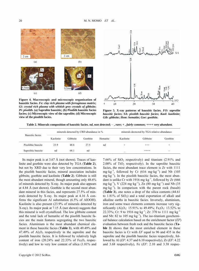
Gi: crystal rich plasma with whitish grey crystals of gibbsite; Pi: pisolith. (a) Saprolite bauxitic; (b) Pisolith bauxitic facies facies; (c) Microscopic view of the saprolite; (d) Microscopic view of the pisolith facies.
Figure 5. X-ray patterns of bauxitic facies. FO: saprolite bauxitic facies; SA: pisolith bauxitic facies; Kaol: kaolinite
de
; Gib: gibbsite; Hem: hematite; Goe: goethite.
tected; – , rare; + , fairly common; ++++ very abundant.
Table 2. Minerals composition of bauxitic facies. nd, non
minerals detected by CRD abundance in % minerals dectected by TGA relative abundance B
Kaolinite Gibbsite atite Kaolinite auxitic facies
Goethite Hem Gibbsite Goethite
Pisolithic bauxite 23.9 48.6 27.5 nd + +++ +
Saprolitic bauxite nd 68.1 nd _ ++++ –
I at 3.67 Å (not shown). Traces of kao-
nite and goethite were also detected by TGA (Table 2), u
7 % of SiO espectively) and titanium (2. and 2.00% of TiO2 respectively). In the saprolite bauxitic
ts major peak islib t not by XRD due to their very low concentrations. In the pisolith bauxitic facies, mineral association includes gibbsite, goethite and kaolinite (Table 2). Gibbsite is still the most abundant mineral, though amounting only 48.6% of minerals detected by X-ray. Its major peak also appears at 4.84 Å (not shown). Goethite is the second most abun-dant mineral in this facies, and represents 27.5% of min-erals detected by X-ray. Its major peak at 4.16 Å con- firms the significant Al substitution (6.5% of AlOOH). Kaolinite is also present (23.9% of minerals detected by X-ray). Its major peak at 7.15 Å (not shown) suggests that this mineral is well crystallized. The low gibbsite content and the total lack of hematite of the pisolith bauxite fa- cies are the main features segregating the two bauxitic facies. Aluminium is the most abundant chemical ele- ment in these bauxitic facies (Table 3), with 49.49% and 47.49% of Al2O3 respectively in the saprolite and the pisolith bauxitic facies. It is followed by relatively high content of iron (20.24% and 22.33% of Fe2O3 respec- tively) and low to very low content of silica (1.81% and
facies, the most abundant trace element is Zr with 1111 mg·kg–1, followed by Cr (616 mg·kg–1) and Nb (105 mg·kg–1). In the pisolith bauxitic facies, the most abun- dant is unlike Cr with 1916 mg·kg–1, followed by Zr (666 mg·kg–1), V (224 mg·kg–1), Zn (80 mg·kg–1) and Nb (35 mg·kg–1). In comparison with the parent rock (basalt) (Table 3), one notes a drop of the silica contents (44.61 to 1.81% of SiO2) and a total exportation of alkali and alkaline earths in bauxitic facies. Inversely, aluminium, iron and some trace elements contents increase very sig- nificantly (Al2O3: 15.91% to 49.49%; Fe2O3: 13.52% to 22.33%; Cr: 9 to 1916 mg·kg–1; Zr: 370 to 1111 mg·kg–1 and Nb: 82 to 105 mg·kg–1). The iso-titanium geochemi- cal balance calculation based on the enrichment factor (EF) evaluation between fresh rock and the bauxitic facies (Ta- ble 3) shows that the most enriched element in these bauxitic facies is Cr with EF equal to 96 and 435 in the saprolite and the pisolith bauxitic facies respectively, fol- lowed by Al (EF: 4.37 and 6.10 respectively), Zr (EF: 4.22 and 3.68 respectively), Fe (EF: 2.10 and 3.38 respec-
.66 2 r 91%
Copyright © 2012 SciRes. OJG

M. N. MOMO ET AL. 21
tively) and Nb (EF: 1.80 and 0.87 respectively) (Table 3).
4. Discussions
4.1. The Doumbouo-Fokoué Bauxite
Two bauxitic facies were identified in Doumbouo-Fok- oué: the saprolite and the pisolith bauxitic facies. Each bauxitic facies has high aluminium contents (49.49 and
spectively) and low to very low silica idences a real addition, the
rrespond to intense
f the Doumbouo-Fokoué Bauxitic Mantles to the Relief Lowering
d on vert f the
c surface was subject to a generalized degradation pr
bau
ements (%) Trace elements (mg·kg–1)
47.49% of Al2O3 recontents (1.81% to 7.66% of SiO2). This evbauxite ore in Doumbouo-Fokoué [2]. Inbauxitic mantles in this region cover a surface area of approximately 5.7 km2; with a mean thickness of 6.30 m and bulk densities of 2.28 g·cm–3 and 2.09 g·cm–3 re-spectively in each facies. In some respects, these bauxitic mantles constitute approximately 9.2 millions tons of baux-ite reserves, and thus can be classified as an important bauxite ore deposit. Since it is located close (less than 20 km) to the Fongo-Tongo bauxite ore deposit it may con-stitute a real additional income. The bauxitic facies in Doumbouo-Fokoué shows macroscopically white grey micrometric punctuations which represent completely weathered plagioclases. Optic microscopy reveals that plagioclases and forsterites are replaced with respect to their volume and shape (pseudomorphosis) by gibbsite and iron bearing minerals respectively. These parent rock remaining features indicate that the Doumbouo-Fokoué bauxite preserved saprolitic nature and then corresponds to ortho-bauxites [19]. The [Fe – Clay – (Al + Ti)] min-erals diagram (not shown) and relatively high Fe contents (20.24% and 22.33% of Fe2O3 respectively) note that they belong to iron rich bauxite [1]. Thus, the bauxite ore deposits in Doumbouo-Fokoué can be classified as the iron bearing lateritic ortho-bauxites.
In Doumbouo-Fokoué bauxitic facies, very abundant silica leaching (EF: 0.06 and 0.35), total exportation of alkali and alkaline earths (EF close to 0.00) and impor-tant aluminium enrichment (EF: 4.37 and 6.10) as well as abundant accumulation of gibbsite suggest that bauxiti-zation in this environment may co
hydrolysis leading to allitization [20]. Allitization, which refers to lateritization process, may be related to abun-
Table 3. Major and trace elements contents of
Bauxitic facies Major el
dant rainfall (1755 mm of mean annual rainfall), dense and dendritic hydrographic network and steep slopes which favoured a highly leaching milieu [21]. Thus, lat-eritization in Doumbouo-Fokoué favoured bauxitization through aluminium mobilization [22] with individualiza-tion of the iron bearing lateritic ortho-bauxites which develop thick bauxitic mantles. In these bauxitic mantles, the saprolite bauxitic facies is located at the bottom, be-low the pisolith bauxitic facies. This vertical organization of the bauxitic facies suggests that the pisolith bauxitic facies likely derive from the saprolite bauxitic facies during geochemical and mineral individualization of bauxitic pisoliths with formation of bauxitic cortex [23], transformation of hematite into goethite and part of gibbsite into kaolinite [24].
4.2. Implication o
In the West and Central Africa, many works focuseical organization and landscape distribution o
bauxitic mantles and their implication to the landscape evolution [1,4,8,9,23,25-27]. They note that these baux-itic mantles are regularly located at the summit of inter-fluves where they form an old and residual surface dominated by a saprolite bauxitic facies and named Af-rican surface by Valeton [1]. These initial bauxitic man-tles were probably formed during early to low Miocene under contrasted climate [28] in an oxidizing-leaching milieu which favoured crystallization of hematite instead of goethite [29]. Thus, the initial relief in DoumbouoFok-oué likely correspond to this old and continuous bauxitic mantle surface slightly slopped southwards which con-sisted of hematite-rich saprolite bauxitic facies (Figure 6(a)).
Since the upper Miocene, the old and continuous bauxiti
ocess [25] resulting into the separation of individual
xitic facies and their enrichment factor (EF).
Zn Nb SiO2 Al2O3 Fe2O3 TiO2 Cao MgO K2O Na2O LOI Cr Zr V
Pisolithic facies SA 7.66 47.49 22.33 2.00 0.01 0.06 0.01 0.00 18.30 1916 666 224 80 35
Saprolitic facies FO2 1.81 49.49 20.24 2.91 0.00 24.6 616
Parent ro (basalt) Ba
En F)
1.
0.00 0.00 0.00 1111 0 0 105
ck 44.61 15.91 13.52 4.09 8.57 5.88 1.79 3.37 0.36 9 370 0 0 82
SA 0.35 6.10 3.38 0.00 0.02 0.01 0.00 435 3.68 - - 0.87
FO2 0.06 4.37 2.10 0.00 0.00 0.00 0.00 96 4.22 - - 1.80richment factor (E
Ba 1.00 1.00 1.00 1.00 1.00 1.00 1.00 00 1.00 - - 1.00
Copyright © 2012 SciRes. OJG

M. N. MOMO ET AL. 22
(a)
(b)
(c)
Figure 6. Landscape lowering of the Doumbouo-Fokoué bauxitic mantles. bauxitic plateaus. This deg n process was favoured by humid equatorial climate [30] and tectonic instability
tly refers to the late Miocene tectonic
t ed we the f , e n Doum uxitic
a rg ner ized r n nd h d ns whic ults to i at n o l y
prolite bauxitic facies. They form thick bauxitic mantles at the summit of interfluves which
fourteen bauxitic plateaus (bowé).
er Pangaea,” In: M.
J. J. Lateritic Bauxites, “De-ogy,” Elsevier, Amsterdam,
radatio
[31] of the region which belongs to the Cameroon vol-anic line. It firsc
activities along the Cameroon volcanic line [15] that contributed to the dislocation of this African surface and its abandonment to intense erosion processes [32]. It also refers to the transformation at topsoil of the saprolite bauxitic facies into the pisolith bauxitic facies during individualisation of pisoliths [33], originating a thick bauxitic mantle with pisolithic facies overlying the saprolite bauxitic facies (Figure 6(a)). It also refers to regressive erosion favoured by the dense hydrographic network which strongly incised the African surface into large and elongated bauxitic plateaus surrounded by deep and profound valleys (Figure 6(b)). It also concerns de-ferruginization at topsoil of the bauxitic mantles where iron bearing secondary minerals are preferably dissolved in a highly leaching milieu [21] as indicated by the drop of Fe2O3 contents (not shown) in fine earth [34,35]. This originated at topsoil a gravelled light soil horizon con-sisting of bauxitic pisoliths and fragments embedded into clayey fine earth [23,36]. The gravelled light soil horizon develops downward at the expense of the bauxitic man-tles. At the same time at topsoil, it is subject to surface erosion [32]. Both processes act together and cause sig-nificant reduction of the bauxitic mantles thickness [34,35,37]. Lastly, the bauxitic mantle degradation in Doumbouo-Fokoué refers to mechanical erosion that causes around the plateaus dismantling of the bauxitic mantles into bauxitic blocks which move down-slopes, inducing bauxitic mantles to reduce in size [8]. All these degradation processes acted together at different scales
undulated bauxitic plateaus completely overlapped to the Bamiléké plateau and then, contributed to general level-ling of the relief in this region (Figure 6(c)). These demonstrations allow relating this bauxitic mantle to the other bauxitic mantles of the African surface (Adamaoua and Bangam in Cameroon, Guinea, Burkina Faso, Ivory Coast and Nigeria) and then to explain the general low-ering of this African surface as noted in the Central and West Africa [1,25].
5. Conclusions
In Doumbouo-Fokoué, important bauxite ore deposits were developed from basaltic rocks during early to lower Miocene under contrasted climates. They correspond to the iron bearing lateritic ortho-bauxite ore deposits with 9.2 millions tons of bauxite reserves. These lateritic bauxites are differentiated into pisolith bauxitic facies locally overlying sa
and con ribut to lo r relie in this area. So sincthe upper Miocene, im
bouo-F deg
okouéadatio
, the u
baer ntles unde o ge al umi
conditio h res in indiv dualiz io f s ightl
have individualizedThe evolution of the landscape attributed to the bauxitic mantles development in Doumbouo-Fokoué differenti-ates three major stapes: Development of the old and residual bauxitic surface
(African surface) during the early to lower Miocene by intense bauxitization process under contrasted climates;
Intense degradation of the African surface favoured by regressive erosion, deferruginization and mechani-cal dismantling of the bauxitic mantle under humid sub-equatorial climate;
General lowering of the relief under the control of the above degradation processes and the joining up of this relief with the Bamiléké plateau.
Thus, bauxitic mantles in Doumbouo-Fokoué, through their landscape distribution, their vertical organization and bauxitic facies evolution, have contributed signifi-cantly to the general levelling of the Bamiléké plateau in the West Cameroon Highlands.
REFERENCES [1] I. Valeton, “Saprolite-Bauxite Facies of Ferralitic Duri-
crusts on Palaeosurfaces of FormThiry and R. Simon-Coincon, Eds., Palaeoweathering, Palaeosurfaces and Related Continental Deposits, Inter-national Association of Sedimentology, Vol. 27, 1999, pp. 153- 188.
[2] G. Bardossy, G. Aleva and G. velopments in Economic Geol
Copyright © 2012 SciRes. OJG

M. N. MOMO ET AL. 23
1990, pp. 27, 6
l’Inde et l’Australie,” Thèse Université Louis
mawa,” Ph.D. Thesis, Erlangen Uni-
iew of German Colonies, 1910
Paris VI,
West Cameroon,” Earth Science Thesis,
ally Related Bauxites Depo-
rres de l’Ouest Cameroun,” Thèse
es Map of the
ton and
w,” Nature, Vol.
ical
ritiques
1989,
himie des Cuirasses Bauxitiques de
, “Les bauxites du Mali. Géochimie et
ol. 107, No. *, 1993, pp. 277-280.
the Mechanism
. Melfi and I. Valeton, “Climats et Paléo-
24.
[3] E. Lee Bray, “US Geological Survey, Mineral Commod-ity Summaries,” United States Government Printing Of-fice, Washington, 2009.
[4] B. Kobilseck, “Géochimie et Pétrographie des Bauxites Latéritiques d’Amazonie Brésilienne, Comparaison Avec l’Afrique,
Char
Pasteur, Strasbourg, 1990.
[5] W. Edlinger, “Contribution to Geology and Petrography of the German Adaversity, Erlangen, 1908, p. 125.
[6] S. Passarge, “The Superficial Structure and Geology of Cameroon,” Annual Rev ,
a
pp. 448-465.
[7] G. Weeksteen, “Preliminary Report on the Fongo Tongo Bauxite ore Deposits,” Report of the Mine and Geology of the Cameroon State, 1957.
[8] S. M. Eno Belinga, “L’Altération des Roches Basaltiques et le Processus de Bauxitisation dans l’Adamaoua (Cameroun),” Thèse Doctorat Etat, Université Paris, 1972, p. 571.
[9] B. Hieronymus, “Study of the Weathering of Eruptive Rocks in the de CôUniversity of Paris VI, Paris, 1985, p. 85.
[10] J. B. Nyobe, “A Geological and Geochemical Study of the Fongo-Tongo and Aresits,” Ph.D. Thesis, Western Highlands, Camroon, 1987.
[11] M. Sojien, “Etude Pétrographique, Minéralogique et Géochimique des Formations Bauxitiques de Bangam dans les Hautes TeMSc., Université Dschang, Dschang, 2007, p. 77.
[12] P. Ntep, “Minerals Resources of the West Region Sub- Divisions,” The Thematic Ores ResourcCameroon, Yaoundé, 2009.
[13] B. Deruelle, C. Moreau, R. Kambou, J. Lissom, E. Njonfang, R. T. Ghogomu and A. Nono, “The Cameroon
l’Af
Line: A Review,” In: A. B. Kampuzu and R. T. Lubal, Eds., Magmatism in Extensional Structural Settings, Springer-Verlag, Berlin, 1991, pp. 274-327.
[14] M. Kwekam, J. P. Liégeois, E. Njonfang, P. Affa
Miné
G. Hartmann, “Nature, Origin and Significance of the Fomopéa Pan-African High-K Calc-alkaline Plutonic Complex in the Central African Fold Belt (Cameroon),” Journal of African Earth Sciences, Vol. 57, 2010, pp. 79-95.
[15] D. G. Nkouathio, D. A. Kagou, J. M. Bardintzeff, P. Wandji, H. Bellon and A. Pouclet, “Evolution of Volcan-ism in Graben and Horst Structures Along the Cenozoic Cameroon Line (Africa): Implications for Tectonic Evo-lution and Mantle Source Composition,” Mineralogy and Petrology, Vol. 94, 2008, pp. 287-303.
[16] R. Maignien, “Manuel Pour la Description des Sols sur le Terrain,” Document ORSTOM, Paris, 1980, p. 112.
[17] D. Njopwouo, “Minéralogie et Physicochimie des Argiles de Bomkoul et de Balengou (Cameroun). Utilisation dans la Polymérisation du Styrène et Dans le Renforcement du Caoutchouc Naturel,” Thèse Doctorat Etat, Université Yaoundé, Yaoundé, 1984, p. 300.
[18] K. A. Rahn and R. J. Mc Cafrey, “Compositional Differ-ences between Arctic Aerosol and Sno280, 1979, pp. 479-480.
[19] B. Boulange, A. Carvalho and A. J. Melfi, “Geochemacteristics of African and Brazilian Bauxites Depos-
its: SiO2-Al2O3-Fe2O3 System and Ti, Cr, V and Fe2O3 Relations,” Geochemistry Earth Surface and Mineral Formation Symposium, 2-8 July 1990, Aix-en-Provence, pp. 30-32.
[20] G. Certini, M. J. Wilson, S. J. Hillier, A. R. Fraser and E. Delbos, “Mineral Weathering in Trachydacitic-Derived Soils and Saprolites Involving Formation of Embryonic Halloysite and Gibbsite t Mt Amiata, Central Italy,” Geoderma, Vol. 133, No. 3-4, 2006, pp. 173-190.
[21] E. Aristizabal, B. Roser and S. Yokota, “Tropical Chemi- cal Weathering of Hillslope Deposits and Bedrock Source in the ABURRA Valley, Northern Colombian Andes,” Engineering Geology, Vol. 81, 2005, pp. 389-406.
[22] M. K. D. Mutakyahwa, J. R. Ikingura and A. H. Mruma, “Geology and Geochemistry of Bauxite Deposits in Lushoto District, Usambara Mountains, Tanzania,” Jour- nal of African Earth Sciences, Vol. 6, 2003, pp. 357-369.
[23] B. Boulange, “Les Formations Bauxitiques Latéte d’Ivoire, ” Travaux et Document ORSTOM, Vol.
175, 1984, p. 341.
[24] J. Thorez, “Argilloscopy of Weathering and Sedimenta-tion,” Bulletin Société Géologique, Vol. 98, No. 2,pp. 245-267.
[25] J. C. Leprun, “Géochimie de Surface et Formes de Relief. IV. la Dégradation des Cuirasses Ferrugineuses. Etude et Importance du Phénomène Pédologique en Afrique del’Ouest,” Science Géologique Bulletin, Vol. 30, No. 4, 1977, pp. 265-273.
[26] Mazaltarim, “Géocrique Occidentale et Centrale,” Thèse Université
Louis Pasteur, Strasbourg, 1989, p. 263.
[27] A. Bourdeauralogie,” Thèse Université Louis Pasteur, Strasbourg,
1991, p. 329.
[28] A. Beauvais and Y. Tardy, “Degradation and Dismantling of Iron Crust under Climatic Changes in Central Africa,” Chemical Geology, V
[29] Y. Tardy and D. Nahon, “Geochemistry of Laterites Stability of Al-Goethite, Al-Hematite and Fe-Kaolinite in Bauxites and Ferricretes: An Approach toof Concretion Formation,” American Journal Sciences, Vol. 285, No. 10, 1985, pp. 865-903.
[30] Y. Tardy, A. Jclimats Tropicaux Péri Atlantiques. Rôle des Facteurs Climatiques et Thermodynamiques (Température et Activité de l’Eau) sur la Répartition et la Composition Minéra- logique des Bauxites et des Cuirasses Ferrugineuses au Brésil et en Afrique,” Compte Rendu Académie Science, Vol. 306, No. 2, 1988, pp. 289-295.
[31] I. Valeton and A. J. Melfi, “Distribution Pattern of Baux-ites in Cataguases Area (SE-Brazil) in Relation to Lower Tertiary Paleogeography and Younger Tectonics,” Sci- ence Géologie Bulletin, Vol. 41, No. 1, 1988, pp. 85-98.
Copyright © 2012 SciRes. OJG

M. N. MOMO ET AL.
Copyright © 2012 SciRes. OJG
24
of Soil Science,” M
,” Compte Rendu Géoscience, Vol. 334, No. 8,
o Belinga and B. Volkoff, “Séquence
ie Science, Vol. 314, No. 2, 1992,
[32] Y. Boulvert, “Aplanissement en Centrafrique. Relation avec le Cuirassement, la Tectonique, le Bioclimat. Pro- Blèmes Posés. Progrès des Connaissances,” Bulletin Asso- ciation Géographes Français, Vol. 4, 1985, pp. 301-309.
[33] G. J. Churchman, “The Alteration and Formation of Soil Minerals by Weathering. Handbook .
200
E. Sumner, Ed., Handbook of Soil Science, CRC Press, Boca Raton, 2000, pp. 3-76.
[34] P. Tematio and K. R. Olson, “Characterization of Two Phases of Encrustment in a Sequence of Ferrallitic Soils Din the South Cameroon and Its Effects on Landscape Evolution,” Soil Sciences, Vol. 162, No. 10, 1997, pp. 758-766.
[35] E. Temgoua, D. Bitom, P. Bilong, Y. Lucas and H. R. pp. 1
Pfeifer, “Démantèlement des Paysages Cuirassés Anciens en
Zones Forestières Tropicales d’Afrique Centrale: Formation des Accumulations Ferrugineuses Actuelles en Bas de Ver- sants
2, pp. 537-543.
[36] D. Bitom, B. Volkoff and M. Abossolo-Angue, “Evolu-tion and Alteration in Situ of Massive Iron Duricrusts in Central Africa,” Journal of African Earth Sciences, Vol. 37, 2003, pp. 89-101.
[37] P. Bilong, S. M. En’évolution des Paysages Cuirassés et des Sols Ferra-
llitiques en Zones Forestières Tropicales d’Afrique Centrale. Place des Sols à Horizons d’Argile Tachetée,” Compte Rendu Académ
09-115.