Embed Size (px)
Citation preview
Narrative Hunger -- GIS Mapping, Google Street View and
the Colonial Prospectus
Ross Gibson
Flat as the table
it's placed on.
Nothing moves beneath it
and it seeks no outlet.
Above -- my human breath
creates no stirring air
and leaves its total surface
undisturbed.
'Map' by Wislawa Szymborska1
There are millions of maps like the one Wislawa Szymborska describes. But in this essay
I’ll be looking at another kind: geographical information systems, which do get stirred
when people engage with them. Arrayed on screens, the surfaces of these interactive
maps are designed to get unsettled. There’s electricity and constant data-accrual
agitating them, letting them change with context and consultation. They are still
accounts of space, these new kinds of maps, but they do not stay still. They alter from
moment to moment, tracking time, showing -- albeit mainly at the somewhat occluded
level of metadata -- a record of everyone who visits them, who gets folded into them.
When users are continuously implicated as stimuli that activate updates within a map,
then it is no longer the old Cartesian thing we thought we knew, no longer an abstract
1 Wislawa Szymborska (translated from the Polish by Clare Cavanagh), ‘Map’ in The New Yorker, 14 April
and rigidly coordinated arraignment purporting to offer disinterested orientation by
addressing every surveyor equally and objectively. Once you have become a participant
and have etched some of your experience into a cartographic system, thereby changing it
with your actions, then the system is dynamic, reactive and not separate from you. It is
not simply an object to your subject. It is not the flat thing Szymborska scrutinises.
Moreover an interactive map stores a narrative that involves you as a character. Indeed
with each new recorded visitation from you, the narrative grows around your character.
And while you might want to regard this character as the protagonist in the mapped
setting, you know in fact that computationally you are no more special than the legion of
other data-packages -- animal, vegetable, mineral and commercial -- that make up the
network that you are negotiating.
See how dubious, how shifty and ruffled the new mapping system really is? This notion
of an active mapping network plainly disturbs the two orthodoxies that have customarily
contended to boss the definition of cartography: namely, the map as a perspectival
setting for narrative and the map as an invariant abstraction that coordinates fixed
information. More about these old contenders, presently.
As Laura Kurgan has acknowledged recently in Close Up at a Distance, her handsomely
designed Zone Books publication, ‘we do not stand at a distance from [the] technologies’
that support geographical information systems. Rather we ‘are addressed by and
embedded within them.’2 In her role as Director of the Spatial Information Design lab at
Columbia University, therefore, Kurgan pursues research projects that:
explicitly reject the ideology, the stance, and the security of ‘critical distance’ and
reflect a basic operational commitment to a practice that explores spatial data and
its processing from within. Only through a certain intimacy with these
technologies -- an encounter with their opacities, their assumptions, their intended
aims -- can we begin to assess their full ethical and political stakes.3
2014, pp. 46 – 7. 2 Laura Kurgan, p.14. 3 Kurgan, p. 14.
They are maps too, of course, the GIS-based systems interrogated by Kurgan; but not as
the West has preferred to know cartography for at least six hundred years. The received
wisdom is that maps locate the world for us, that they are stable and dependable out in
front of us. You can read them as if they offer a natural language because, from the
earliest explorations in which you used maps to find your way and assert your agency in
the wide world, you have absorbed and appreciated the efficacy of all their ‘conventions,
ranging from their legend, scale and codes of graphic representation to what counts as
the information that they represent’ as they give you ‘a system of notation or coordinates
that places things in relation to one another.’4
When these traditional maps serve so well, they do not seem to deserve interrogation,
doubt or disturbance. They take you places; so endorse them, treat them as natural, and
carry on. Which is another way of saying that the classic Cartesian map lets the viewer
hover potently outside its chart; no participant breath shifts the well composed data
which is trusted to stay constant and clarifying.
We know this implicitly and most people trust those solid-state coordinates comfortably.
But with Kurgan’s help, let’s not dodge what we’ve come to understand since our
phones got smart and started talking amongst themselves while we carried them around:
This drive to locate, to coordinate, however revelatory and even emancipatory it
can be, also has its price. It seems as though in the end, maps – the successful
ones, the ones that show us where we are and get us from here to there -- risk
offering only two alternatives. They let us see too much, and hence blind us to
what we cannot see, imposing a quiet tyranny of orientation that erases the
possibility of disoriented discovery, or they lose sight of all the other things that we
ought to see. They omit, according to their conventions, those invisible lines of
people, places, and networks that create the most common spaces that we live in
today.5
So what happens if you take one of Kurgan’s more quixotic provocations seriously, once
you’ve paused and glommed to how GIS systems really do work in the palm of your
4 Kurgan, p. 16.
hand, now that all people with phone accounts (rather than only national-security
agencies) have access to the GIS datascape even as they contribute to its massification?
Kurgan puts it like this:
The word ‘data’ … means nothing more or less than representations, delegates or
emissaries of reality … not presentations of things themselves but
representations, figures, mediations -- subject, then, to all the conventions and
aesthetics and rhetorics that we have come to expect of our images and narratives.
All data, then, are not empirical, not irreducible facts about the world, but exist as
not quite or almost, alongside the world; they are para-empirical.6
What might happen is that you could step off from your ‘comfortable sense of
orientation, of there being a fixed point, a center from which we can determine with
certainty where we are, who we are, or where we are going.’7 And by doing so you
might comprehend yourself not as a sovereign point blessed with an executive overview
of a conclusively quantified and invariant field, but rather as a flowing, ever-contingent
and shifting agglomeration within a relational network. You could begin to know a
world in which change is definitive rather than disallowed and regulated into charted
stasis. The coordinates that Cartesian systems install against doubt and contingency
would float more freely. Relativity would abide instead. For good as well for dread.
The objective, as Kurgan offers it, is to ‘put the project of orientation – visibility,
location, use, action and exploration – into question … [but] without dispensing with
maps.’ Thus one might get a more telling access to everyday reality as it actually roils
nowadays -- the world as it is rather than as we might wish it to be -- which old-style
Cartesian maps can occlude or ignore. To finish this thought and to agitate the solid
world, Kurgan borrows a tagline from Rosalyn Deutsche, declaring that contemporary
reality is actually ‘constituted in a complex of representations’ which realign and re-
charge constantly, depending on the valences operational at any particular time and
place in the network.8
5 Kurgan, pp. 16 – 17. 6 Kurgan, p. 35. 7 Kurgan, p. 17.
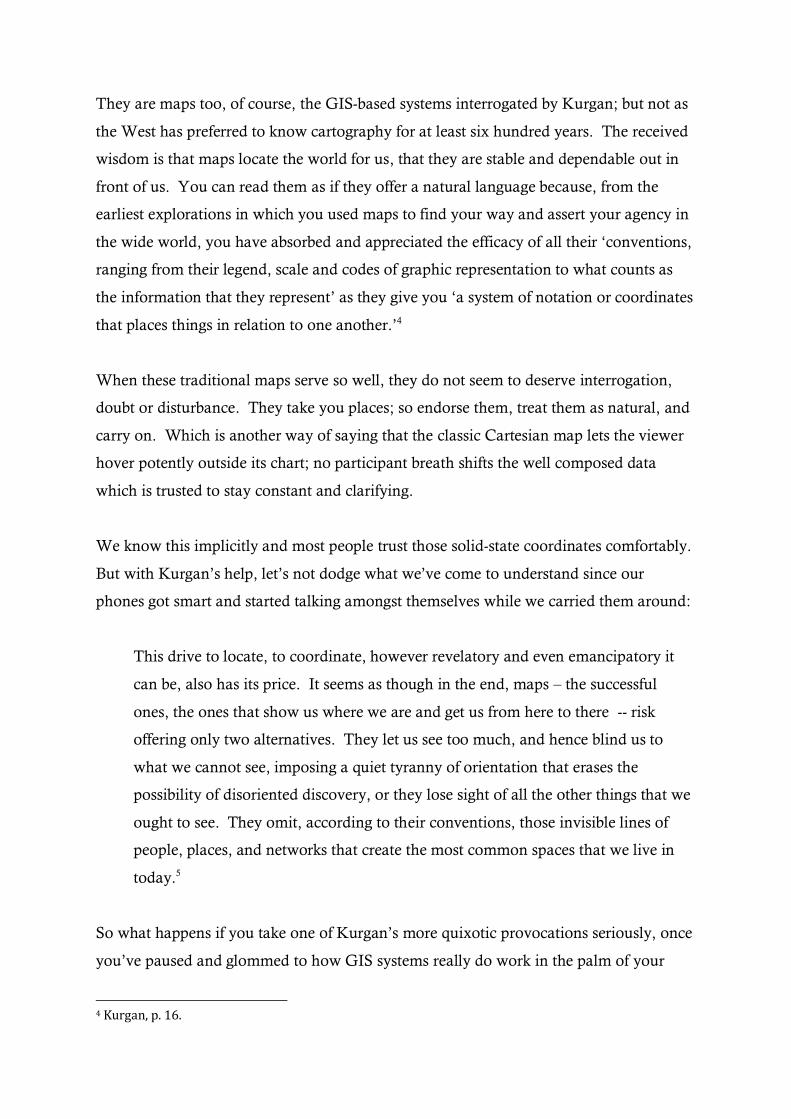
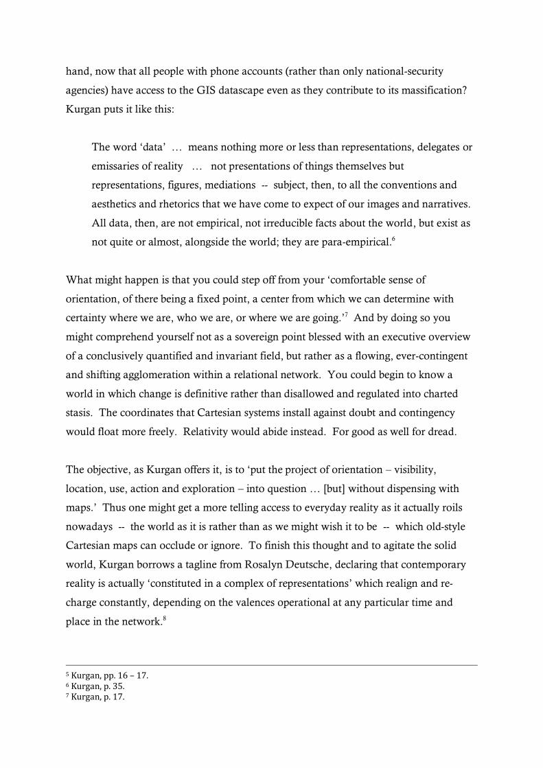
Kurgan works a canny gambit to get us used to interrogating ‘the project of orientation’.
She displays two NASA images of Planet Earth: File AS8-14-2383 which is popularly
known as ‘Earthrise’; and AD17-148-22727 which is celebrated as ‘The Blue Marble’.
These public-domain pictures, with their striking backgrounds of deep-space black, are
usually celebrated as gorgeous colour studies. They have been printed out and posted up
to bring cheer to countless dorms and bedrooms. The tasty foreground of musks and
greys in the first photo offsets the chilly southern blues counter-posed with beckoning
northern reds in the second. But for the cartographically inclined, the important
difference is that one image is a landscape which acts as a narrative setting and the other
is an abstract figure which usually gets regarded as a map of Africa.
8 Kurgan, p. 17.
Addressing a protagonist standing sovereign at the apex of its scene, ‘Earthrise’ offers a
perspectival track into a journey -- how did you get here on this lunar plain and where
are you about to go? ‘The Blue Marble’, however, displays the ‘total surface’ (to invoke
Szymborska again) of the planet’s primordial continent and it hovers you nowhere,
without a particular standpoint. The first image involves you in a narrative, suggesting
possible trajectories for yourself foreground to yonder; the second extracts you
schematically, offering an empirical, Cartesian assay of space outside of you. In this
difference between the two images -- the poetics of a first-person narration versus the
empirics of an encompassing survey -- we have a distinction that helps us understand
the animus of contemporary mapping. From ‘The Blue Marble’ to ‘Earthrise’, you shift
from over there to in here, becoming implicated in a landscape that hosts a story for you.
Nowadays GIS takes this interpolation into endless, ever-altering real-time as every point
in the updating network cross-references against every other point; and it refuses to line
up perspectivally or lie still cartesianally . Which brings us back to Kurgan’s interest in
the collapse of critical distance, seeing that a landscape, a Cartesian map and a
metadata-rich information-network are all spatial somehow but by no means
commensurate. It is this move from the planar abstraction of Cartesian mapping to the
landscape-view of journey-tracing and beyond into continuously updating feedback systems
that is presently redefining how maps are made and used.
Pinging satellites have been crucial in this move, allowing a more axonometric kind of
view that transitions the surveyor from the affectless hover-point above a map to
something closer to a ‘real-world’ witness-proximity, even though the viewing-device is
actually in outer space. To this end, Kurgan features (and pays for) a striking image in
her book. She describes it as follows, and it is well worth seeking out online, to feel the
vertigo and the narrative poignancy that springs from the plummeting vantage-point. It
presents:
a one-meter resolution satellite image of Manhattan … collected at 11.43 a.m.
EDT on September 12, 2001, by Space Imaging’s Ikonos satellite. The image
shows an area of white dust and smoke at the location where the 1,350-foot towers
of the World trade Center once stood. Ikonos travels 423 miles above the Earth’s
surface at a speed of 17,500 miles per hour.9
The column of vapour gyring up toward you is a bridge between the abstract world of
mapping and the closely-felt testimonial world of time-coded and landscape-set
storytelling. You can almost smell it. This poignant index of an actual event -- which
occurred in real time in a space you can visit -- shifts the image back and forth between
map and scenario, between information and all the emotion-laden complexity that
stories carry even as they also freight and delineate great loads of data.
With all this melding of scene-setting and mapping, the paradigm-shifter has been
Google Street View, which links ‘on-the-ground’ landscape-renditions to traditional
coordinate-charting via GIS surveys and networked user tracking. At will you can shift
yourself inside and outside the scene, then back inside again, and so on, blending
distance and involvement within a mode of knowing that is both intensive and extensive.
Try monitoring yourself as you work with Google Maps. Most likely you’ll start by
typing a location-search. These words will give you a schematic map that you can
change into a zoom-able satellite view before you go back to the map in order to activate
Street View. At this moment you get folded into a grounded vista, ‘travelling’ and
narrating along perspective-lines that you select within the 360-degree half-dome of
vision that is availed by your cursor-clicking within the website. And all the while, you
know that you can float out to abstraction again at any moment, to hover at a critical
distance outside the ‘total surface’ that is always offered by the Google Map schema, as
distinct from the Google Earth setting or the Google Street View trajectory. Inside,
outside, inside, and so on.
For me, the most striking aspect of journeys taken along Street View’s infinite itineraries
is the ‘narrative hunger’ they stimulate. I fashion this term from David Shields’ popular
study of non-fiction writing, Reality Hunger, in which he accounts for the amplifying
interest in witness-reportage.10 With a narrative hunger, I suggest, viewers encounter a
setting that compels them to scan for cues about what to feel and what to tell in response
9 Kurgan, p. 128.
to the scene. The hunger intensifies if the scene befuddles or if it fails to divulge, if the
viewers find no reliable cues, nothing semantic or affective to prompt a satisfying story.
Coming up empty, lost in blankness, the viewers know narrative hunger. And they may
respond with utterance.
Go travelling with Street View. You’ll see what I mean. The blankness emanates from
the aesthetic qualities in each image but also from the automated rhythm of image-
capture as the Google Car trundles along. The 360-degree Google Camera makes no
subjectively nuanced selection with each framed and snapped image; it just operates
indiscriminately all around itself on clock-time. It just blinks and plods on. Vernacular
parlance has dubbed it ‘zombie-cam’. This nickname evokes well the amorality of the
images. But I’d like to add ‘stumble-cam’ to the lexicon. For it’s as if the mobile camera
is concussed and unfocused as it travels, thoughtless and uncaring, on auto-pilot, nothing
invested. As it moves implacably into the landscape, the Google Camera gobbles up a
vast territory of future prospects. It stitches no obvious stories into its journeys, but it
lays out a plethora of settings in anticipation of future values that could be poured into
them.
In this regard, the journeys of the Google Camera are prospectuses awaiting ‘investors’,
be they monetary speculators, be they narrative. Of course, there are thousands of
projects online that have been roused by the narrative hunger. A profusion of artists, for
example, have poured significance into the blank scenes, offering narrative texts,
providing soundtracks and musical cues, or selecting poignant images that lift the
viewing experience out of the automatic daze that zombie-cam engenders.11 But overall
the daze prevails. Image-sequences in Street View almost always arise with a rhythm
that feels somnolent rather than pointed, pre-destined or sovereign. In other words,
there’s currently not much triumphalist colonialism or energetic modernism on display
in Street View. (Which is not to say the system will always be so wide open, so blank
and multi-valent.) In the myriad post-colonial scenes of sociological and ecological
devastation that the Google Car has captured all around Australia, one cannot help but
feel that the sovereign viewer has been rendered catatonic somehow. There’s been a
10
David Shields Reality Hunger: A Manifesto, New York: Knopf, 2010.
shift of gears. Centuries of manifest destiny and perspectival privilege have led to
lostness, to paralysis, to a befuddlement about where you can drive next for satisfaction
or profit. Perhaps this is melancholic: the cessation of movement. Or perhaps it is
optimistic: the call for a surge in new kinds of spatio-temporal encompassment.
It’s the process of moving through the landscape -- specifically of moving for the
purposes of surverying and mapping -- that demands and rewards our attention
here. John Barrell, in his ‘landmark’ books The Dark Side of the Landscape and The
Idea of Landscape, offers astute guidance for this topic, with his canny analyses of
rural politics and poetics in early-industrial England.12 He examines the assault that
fell upon the commons during the Eighteenth Century when land-tenure was
forcibly altered across most of Britain so that extensive tracts that had long been
held, farmed and husbanded communally, in a ‘traditional’ way, were transformed
to become intensive, enclosed estates that were owned personally, sequestered and
exploited, in a ‘modern’ way. Barrell shows how the twinned phenomena of the
Industrial Revolution and the Agricultural Revolution coincided in Britain not so
much because farming was revamped by the invention and sudden availability of
new machinery, as has been long surmised. Rather a change in mentality probably
occurred first throughout the most powerful section of the populace, Barrell
contends, causing a cultural change that encouraged landgrabbing and the adoption
of an entrepreneurial attitude to estates. Which led to the countryside being treated
as an object full of raw materials and natural resources. Among the class of men
who realised they could exert their influence, the rural world was redefined as an
agricultural object that could be processed with the efficiency afforded by the
mechanical advantage and energy-transfer that were the drivers of the Industrial
Revolution. The change in the culture governing farm-tenure brought a reason for
the Industrial Revolution to lock on to rural economies as well as to urban
factories.13
11 Three instances: Mishka Henner’s ‘No Man’s Land’ [http://www.mishkahenner.com/No-Man-s-Land]; Jon Rafman’s ‘9 Eyes’ which ponders the aesthetics and the seeming amorality of the 9-lensed surround-camera [http://9-eyes.com/]; my own ‘Wayfaring Strangers’ [rossgibson.com.au]. 12 John Barrell, The Dark Side of the Landscape: the rural poor in English painting 1730 - 1840, Cambridge: Cambridge University Press, 1980; and John Barrell, The Idea of Landscape and the Sense of Place 1730 - 1840; an approach to the poetry of John Clare, Cambridge: Cambridge University Press, 1972.
As they acquired portfolios of estates, the new landed speculators became owners
rather than tenders. No longer was it obvious that a person should come from and
belong to one particular place. And someone who owns many places can quickly
become accustomed to the idea that it is good to move through these places and to
move from place to place as a celebration of personal sovereignty. These parvenu
property-owners were part of a new ‘rural professional class … whose interest in
the land was not primarily aesthetic’, who were ‘accustomed, by their culture, to the
notion of mobility and could easily imagine other landscapes’.14 They had found a
modern, industrially efficient way to be in the spaces that they had requisitioned,
encompassed and reaped with a mobility that afforded them a kind of proprietorial
ubiquity.
It is a simple next step to regard all land as matter waiting to be landscaped. In this
process every representation of the countryside quickly appears like a profiteer’s
prospectus, like an offer to convert raw or natural resources to product and
property. For good and for bad, Google Street View is the latest phase in this long
march across the planet’s territories. In Australia, with Google’s extensive
photographic coverage of the continent’s vastness, Street View mapping allows a
mode of virtual travelling that feels like free and benign browsing, as if the
intensively enclosed territories of the gridded world have been opened up and held
in common again. (That little Google Car has been to an extraordinary proportion of
Australia; not just to the cities and suburbs, but along tens of thousands of dirt
tracks and corduroy roads that very few citizens have ever traversed.) But dating
from 1788, when the first colonising garrison was established at Sydney Cove, there
has been a long and troublesome history of this style of movement, this ‘prospectus
mode’ of hungry mobility.
In post-1788 Australia many of the explorers and settlers who forged into the
landscape published travel accounts. Or more precisely, they produced traversal
accounts. Celebrating acquisitive movement in the way Barrell has explained, these
accounts compiled inventories that assayed a vast stockyard. The accounts were
13 Barrell, The Idea of Landscape, pp. 60 - 1 14 Barrell, The Idea of Landscape, pp. 62 - 3.
guide-books for prospective entrepreneurs looking to launch their ambitions across
new fields of profit. Of course, the newness terrains could be credited so long as the
traversers did not tarry to witness the methodical land husbandry performed by
Indigenous custodians, so long as the traversers declined to note that the entire
country was already braced with infrastructure and design that had been made and
maintained during centuries of native diligence. In this sense, all the traversal tales,
even today’s, are colonial prospectuses, tabulations of assets and entrepreneurial
opportunities. Self-assertion and continuous acquisition, rather than communal and
ecological custodianship, are paramount in these traversal ventures.
Here’s a bravura example from the middle of the 19th Century, a whooping paean to
territorial mobility. It was published by Major Thomas Mitchell, first Surveyor-General
of New South Wales and keeper of the colony’s cadastral records. Mitchell reminisces
about an invigorating day exploring a wild tract out past a hamlet’s edges:
The calls of the natives, first heard at a distance in the woods, having become more
loud, and at length incessant, I answered them in a similar tone; and having halted
the carts, I galloped over a bit of clear rising-ground, towards the place from
whence they came.15
Such momentum carries him imperially as well as imperiously:
We now advanced with feelings of intense interest into the country before us, and
impressed with the responsibility of commencing the first chapter of its history.
All was still new and nameless there, but by this beginning we were to open a way
for the many other beginnings of civilised man and thus extend his dominion over
the last holds of barbarism.16
Motoring forward one hundred and fifty years, I think it’s not too fanciful to regard the
Kennedy-Miller Company’s Mad Max films as part of this cultural tradition. Actually, the
films are critiques rather than continuations of the mania for mobility. With their
15 Thomas Livingstone Mitchell, Three Expeditions into the Interior of Eastern Australia, 2 Volumes, London: T. & W. Boone, 1838, Vol. 1, p. 210.
dystopian vision of what the urge to roam and rule can produce, they play out a
scatologically thrilling endgame for voracious momentum. Offering a raucous
completion to the hollering that Mitchell initiated, the films have struck a chord with
massed audiences for more than thirty years, from the period of their production when
the oil crisis and ecological collapse first smacked into popular consciousness
worldwide. They drive the imperial tale of acquisitive traversal to a mad kind of
apogee. They are hypercharged with an explicit narrative mission: ride the white line
fever to a flaming climax. This is unequivocal. The viewer needs not supply any extra
meanings or thematics.
By contrast, what’s striking about the road movies that Google Street View supplies is
that the narrative repletion driving the Mad Max films has evaporated from the
landscapes. Even while it takes account of tracts of land that can be tagged as data to be
leased out as a type of real estate -- much as Thomas Mitchell did when he published
his journals -- the Google Car seems stuck in first gear, so unlike the turbo-boosted
muscle cars in the Mad Max films. Indeed, so unlike Mitchell’s galloping steed!
Something has changed in the vantage we have now on space and place and time.
It’s this. Even as Google continues the project of acquisitive traversal that capitalism
and colonialism have impelled for centuries, it is doing something else too, perhaps
inadvertently. The Street View/GIS nexus has brought the narrative hunger. Which is
an unexpected affordance, I suggest, of the new technology. With the Google Car, the
story that is meant to be ascribed to the journey is no longer obvious, no longer
presumed and credited, as it was when an avid sense of manifest destiny sustained the
colonial venturers. With the zombie-affect of the stumbling, nine-eyed camera, no
singular trajectory gets comfortably proposed. Instead of the colonialist narrative drive,
instead of the modernist energy, we encounter diffused or ‘ambient’ perspectives and
divergent throughlines.17 The settings in Street View feel unfocussed and ‘agnostic’ of
destination; if you were to stitch traverser’s tales into the scenes they would be plotted
along several trajectories, out of several memories or toward many dissociated
intrigues. The concussed and extensified journeys availed by Street View feel different
16 Mitchell, Three Expeditions, Vol. 1, p. 36. 17 Acknowledgements to Nikos Papastergiadis, in conversation, for this idea of ‘ambient perspective’.
from the rifling paths, so focused and intensified, that have already been scored by
Mitchell and Kennedy-Miller. There’s a feeling of blankness in the Googlescape, a
manifest lack of narrative prescription. Encountering Street View, the traveller feels a
strong yen to get involved with systems of stories. Ironically, the traveller yearns for
something ‘indigenous’: a kind of orienting and all-encompassing story-network or
mythology. The yearning that you sense in Google’s blankland is a hankering for
‘country’, a hunger for the system of place-tagged fabulations, dances, songs, painting,
rituals and embodied memories that are kept and cosseted by the inhabitants (as
distinct from the temporary travellers) in a storied domain. Country criss-crosses a
terrain in all directions, netting the meanings and emotions, the obligations and
warnings that need to be acknowledged and retained as you find yourself and make
your way through the place where you’ve landed, where you live. It’s easy to invoke –
this notion of country -- but arduous to install and sustain, millennial in duration. So
it’s a naïve and alarmingly rudimentary emotion, this parvenu hankering for country
that one feels in the Street View blanklands. But there it is, calling for a new start.
With Street View, the undead landscapes that the stumble-cam captures all have a
vacuum in them. But they are strangely rousing nevertheless, no matter how meager,
how depleted. I’m reminded of Jay Leyda’s brilliant insight that Emily Dickinson’s
utterances are so compelling because they have at their core an absence or silence
where you would expect to hear divulgence, and in response to this ‘omitted center’ the
reader floods feelings and notions into the exquisitely composed void.18 Dickinson
created this effect deliberately. With Google, I think, the structuring absence is
accidental. But it’s there nevertheless.
In summary, then, here is my thesis, offered with thanks to Kurgan and Barrell for
lighting up Thomas Mitchell’s journals and the Mad Max movies with a fresh
orientation:
There is an activating void in Google Street View which is an effect both of
aesthetic qualities of the Google Camera’s 360-degree pictorial field and of the
18 Jay Leyda, The Years and Hours of Emily Dickinson, North Haven (CT): Archon Press, 1970 (first published 1960, Vol. 1, p.xxi.
mechanical triggering of the camera’s automatic sequencing. The absence of
meanings and feelings plus the lack of a singular perspectival impetus in the
imagery stimulates in the viewer an urge both to offer stories that account for the
appearance of the scenes and to inhabit those scenes with human history.
Effectively, the wraparound landscapes of Street View spur viewers to append
tales to the journeys via Google’s pinning systems and via there own blogs and
aggregation communities. Thus viewers can begin to participate in the narrative
enrichment of the Googlescape’s vacuous settings. More than being receivers of
stored-up information, the viewers have the chance – singly and communally – to
be contributors to the meanings and structures of feelings that give value to these
landscapes which have been mapped as Google have compile a kind of prospectus
for future profitable uses of the traversed territories. Thus in their networked
communality, these contributors have a chance to integrate a shared system of
narratives which invest the traversed spaces with significance so that the most
basic rudiments of a new kind of country-telling might start to take shape. Over
time, as people offer their tales to fill the absences all over the Googlescapes, these
contributors could become participants in country-keeping as they interact to
make and maintain an ever-adjusting weave of plenteous and demotic narratives
that hold information and emotion suffusing the entire, interconnected
environment that hosts all the participant storytellers. Immersed, and involved.
Not critically distanced, these participants could make what James Agee once
envisaged as a ‘living map’ created by the prodigious testimonial work he craved
to facilitate in this account of Alabama n Let Us Now Praise Famous Men:
let me hope the whole of that landscape we shall essay to travel in is visible
and may be known as there all at once; let this be borne in mind, in order
that, when we descend among its windings and blockades, into examination
of slender particulars, this its wholeness and simultaneous living map may
not be neglected, however lost the breadth of the country may be in the
winding walk of each sentence.19
To finish, resolving not to be stymied by the fact that this new, online mode of country-
keeping is almost risibly inchoate at present, let’s work a little harder with this idea of
the participant in the living map. Let’s see what can be done. With Google Street View,
even as you serve the company by making data with your every action, you also become
more than a participant; to a significant extent you are an operator of the viewing field,
as you select the perspective and the trajectory of the Google Camera’s journey. You
attain a modicum of agency and responsibility. Operators are not readers or receivers.
They can respond actively to the narrative hunger that presently aches in the Street
View landscapes. Life in the Data Republic of Google is no Utopia. Indeed it feels
increasingly like an oligarchy as well as a kind of political octopus, plainly, but there is
something substantively fresh -- for the moment at least -- about the scenes that the
company displays via its mapping systems.
In the Australian footprint of the Googleverse, we seem to be at a point of balance
between plenitude and vacuity, a special point where the extensively measured and
photographed environment is uncannily open for reimagining even as it is also being
thoroughly itemized by the stocktaking of Google. For a myth can sometimes cause
history to happen (as Ernst Cassirer so famously asserted20) and a map can lead people
back into country where no one has ventured in several generations, if ever at all. So
we have a chance to undercut, enrich and overlay the new acquisitive actions of Google
and all the other data-miners. We can do this with fresh accounting, fresh narrating and
fresh place-making in this our hyper-colonised sector of the dataverse. Curiously,
unintentionally, we have been given a machine -- this zombie-cam and its attendant
satellites and networks -- that might help us care for country in some new way, instead
of just continuing to grab land in the old colonial way.
19 James Agee, Let Us Now Praise Famous Men, first published 1941, reprinted London: Picador Classic, 1988, p.111. 20 See Ernst Cassirer, The Philosophy of Symbolic Forms, Volume Two: Mythical Thought, New Haven: Yale University Press, 1955, p. 5: “In the relation between myth and history myth proves to be the primary, myth the secondary and derived, factor. It is not by its history that the mythology of a nation is determined but, conversely, its history is determined by its mythology -- or rather the mythology of a people does not determine but is its fate, its destiny as decreed from the very beginning.”