Embed Size (px)
Citation preview
NASA Contractor Report 165967
NORSEX 79
MICROWAVE REt10TE SENSING
DATA Sur·1MARY REPORT
SEPTEMBER 29 - OCTOBER 12, 1979
NASA-CR-165967 19820025920
HAROLD F. HENNIGAR AND SALLY K. SCHAFFNER
THE BIONETICS CORPORATION HAMPTON, VIRGINIA 23666
CONTRACT NASl-16978 MAY 1982
NI\5/\ National Aeronautics and Space Administration
Langley Research Center Hampton, Virginia 23665
l~BRARY COpy JAN ~ 0 .
LANGLEY RESEARCH CENTER LIBRARY NASA
HM.1PTON, VIRGINIA
https://ntrs.nasa.gov/search.jsp?R=19820025920 2020-05-10T23:45:57+00:00Z
TABLE OF CONTENTS
SUMMARY
SECTION 1 •
INTRODUCTION
DATA ORGANIZATION .
SECTION 2 • . • . . •
SENSOR DESCRIPTIONS
STEPPED FREQUENCY MICROWAVE RADIOMETER
AIRBORNE MICROWAVESCATTEROMETER . . . . . . . PRECISION RADIATION THERMOMETER •
SECTION 3 . .
SENSOR GEOMETRY • .
SECTION 4 . .
NORSEX DATA SET SUMMARY • i· ,
SECTION 5 . •
NORSEX DATA EXAMPLE .
BIBLIOGRAPHY
GENERAL • • .
INSTRUMENTATION .
NORSEX
APPENDIX A: AERIAL PHOTOGRAPHY LOG AND ORDERING INFORMATION . • .
...
v
1
1
4
7
7
7
14
23
25
25
34
34
39
39
44
44
45
45
47
APPENDIX B: NORSEX DATA TAPE DOCUMENTATION . • • . 52
i

APPENDIX C:
DAY 272
DAY 274
DAY 277
DAY 281
DAY 283
DAY 285
TABLE OF CONTENTS
NORSEX TIME LINE PLOTS AND FLIGHT LINES • • • • •
. . . . . .
ii
60
61
81
.. III
• 133 . . . 161
• 190
Figure
1
2
3
4
5
6
7
8
9
10
11
12
13A
13B
LIST OF FIGURES
The NASA C-130 Aircraft • • . . •
Map of the NORSEX Experiment Area
Stepped Frequency Microwave Radiometer
Front Panel View of the Digital Controller for the Stepped Frequency Microwave Radiometer
Block Diagram of the Stepped Frequency Microwave Radiometer • • • •
Simplified Block Diagram of the Airborne Microwave Scatterometer • • • • • • •
Scatterometer Gimbal Assembly on C-130 Aircraft . . . . . . . . . . . . . . . . .
Scatterometer Transmitter/Receiver
Rack-Mounted Electronics for Scatterometer
Arrangement of Sensors on-board the NASA C-130 . . . . . . . . . . . .
SFMR Footprints
Time Line Plot .. . Example of Sensor Data
Example 70f Sensor Data
"
iii
3
8
9
11
15
16
16
17
26
30
36
40
41
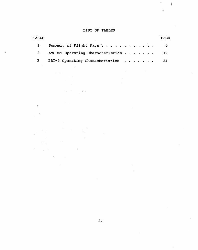
LIST OF TABLES
TABLE
1 Summary of Flight Days • • . • • • • • • •
2
3
AMSCAT Operating Characteristics • • • • •
PRT-5 Operating Characteristics ..••••
iv
PAGE
5
19
24
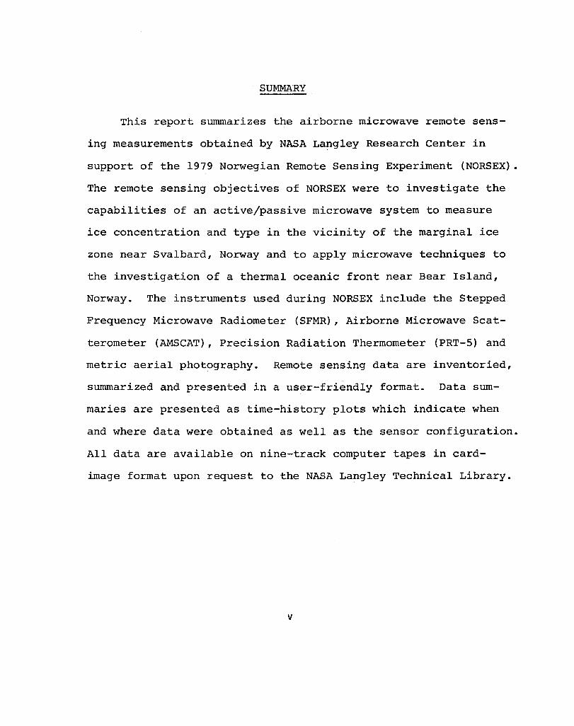
SUMMARY
This report summarizes the airborne microwave remote sens
ing measurements obtained by NASA Langley Research Center in
support of the 1979 Norwegian Remote Sensing Experiment (NORSEX).
The remote sensing objectives of NORSEX were to investigate the
capabilities of an active/passive microwave system to measure
ice concentration and type in the vicinity of the marginal ice
zone near Svalbard, Norway and to apply microwave techniques to
the investigation of a thermal oceanic front near Bear Island,
Norway. The instruments used during NORSEX include the Stepped
Frequency Microwave Radiometer (SFMR), Airborne Microwave Scat
terometer (AMSCAT), Precision Radiation Thermometer (PRT-5) and
metric aerial photography. Remote sensing data are inventoried,
summarized and presented in a user-friendly format. Data sum
maries are presented as time-history plots which indicate when
and where data were obtained as well as the sensor configuration.
All data are available on nine-track computer tapes in card
image format upon request to the NASA Langley Technical Library.
v
SECTION 1
INTRODUCTION
This report summarizes the airborne remote sensing data
sets obtained by NASA Langley Research Center in support of the
1979 Norwegian Remote Sensing Experiment (NORSEX). The remote
sensing objectives of NORSEX are listed below in order of
priority:
(1) Evaluate the capability of an active/passive micro
wave system to measure ice concentration and type near
the Marginal Ice Zone (MIZ) north of Svalbard, Norway.
(2) Investigate the microwave signature of a quasi-perma
nent thermal oceanic front (Polar Front) in the vicin
ity of Bear Island, Norway.
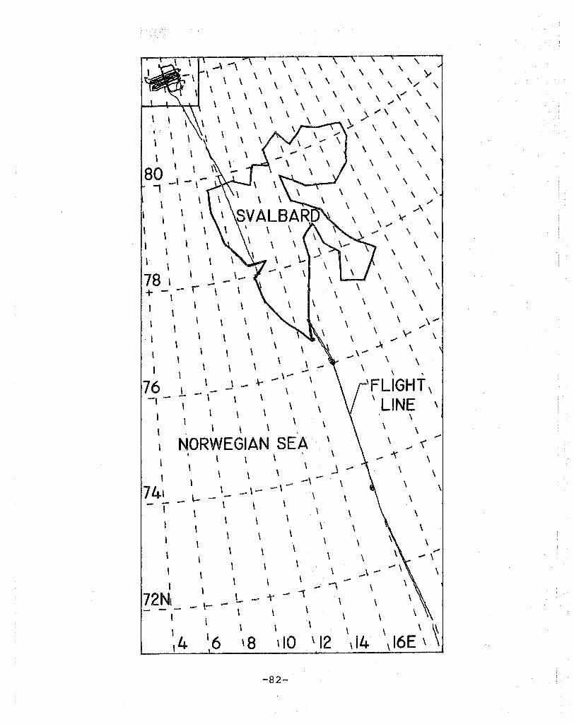
Six flights were conducted over the region during September
and October 1979 using the NASA C-130 aircraft shown in Figure 1.
The flights were staged from Tromso, Norway with refueling stops
at Longyearbyen p located in Svalbard, Norway. The first two
flights were made in conjunction with ship-borne microwave mea
surements performed aboard the Norwegian icebreaker Polar Circle,
which was located in the marginal ice zone. Ancillary oceano
graphic measurements were also obtained by the Polar Circle in
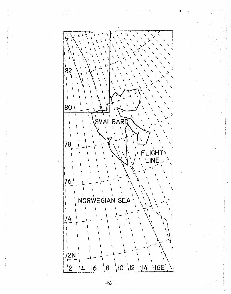
the marginal ice zone and in the polar front area. Figure 2 is
a map of the region including Tromso, Svalbard, the marginal ice
zone and the polar fronto A summary of flight days is presented

Fi gure 1. The NASA C-130 Aircraft (NASA 929)
2···
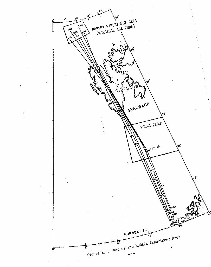
• ,( ~a? of tne "O~f~ f~?ef\ment ~fea
in Table 1. NASA Langley sensors on board the C-130 aircraft
included a 14.6 GHz Airborne Microwave Scatterometer (AMSCAT),
and a 4.5 to 7.2 GHz Stepped Frequency Microwave Radiometer
(SFMR). A thermal infrared radiometer (PRT-5) and two Zeiss
6-inch focal length metric cameras were also used. Descriptions
of these instruments are provided in the next Section.
DATA ORGANIZATION
The primary objective of this report is to present the re
mote sensing data collected on the mission in a user-friendly
format. Data are organized by flight day and are referenced to
Greenwich Meridian Time (GMT). Data summaries are presented in
Section 3 as time-line plots and indicate when and where the
data were obtained, as well as the sensor configuration. All
data have been inspected and time-corrected, where appropriate,
and are available on nine-track computer tapes in card image
format upon request to the NASA Langley Technical Library (See
Appendix B). Upon inspection of the time-line plots a user can
access a specific data segment by searching the tapes for the
appropriate start and stop time. Selection of data for detailed
analysis will depend upon the requirements of the user. The
data have been organized so that selection is easiest if the
user has a particular sensor configuration in mind, or is inter
ested in a particular geographic location. No attempt at de
tailed analyses has been presented in this report, and users are
-4-
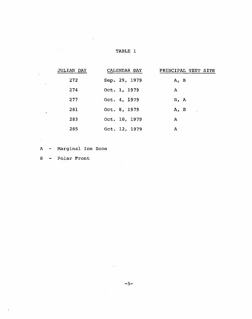
TABLE 1
JULIAN DAY CALENDAR DAY PRINCIPAL TEST SITE
272 Sep. 29, 1979 A, B
274 Oct. 1, 1979 A
277 Oct. 4, 1979 B, A
281 Oct. 8, 1979 A, B
283 Oct. 10, 1979 A
285 Oct. 12, 1979 A
A Marginal Ice Zone
B Polar Front
-5-
urged to apply their own methods of analysis to the data. It is
hoped that by making these data available, many alternative
methods of analysis will be developed and applied.
In general, aerial photography serves as ground truth over
the marginal ice zone (See Appendix A). Limited oceanographic
data, in report form, are also available for the marginal ice
zone, the polar front, and certain other areas. A bibliography
lists pUblications of general interest as well as those dealing
specifically with NASA Langley instrumentation and the NORSEX
experiment.
-6-

SECTION 2
SENSOR DESCRIPTIONS
STEPPED FREQUENCY MICROWAVE RADIOMETER
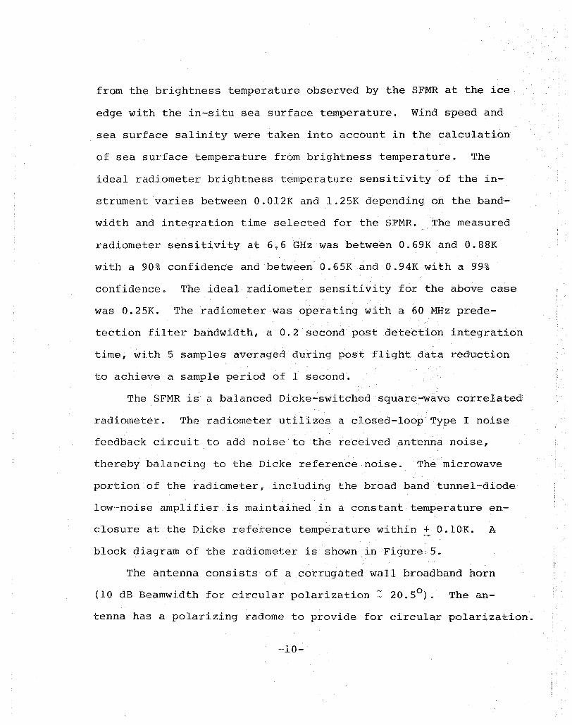
The Stepped Frequency Microwave Radiometer (SFMR) is a
precision, nadir looking, circular polarized radiometer designed,
developed and fabricated by Langley Research Center. SFMR is
believed to be the first variable frequency microwave radiometer
controlled by a digital microprocessor which provides both radio
Ineter control functions and real-time data processing. The
radiometer antenna, microwave portion and signal processor are
shown in Figure 3$ The front panel of the digital controller
is shown in Figure 4e
The SFMR is capable of operating at frequencies between
4.5 GHz and 7.2 GHz at bandwidths of 10, 50, 250 or 1000 mega
hertz with integration times from 0.2 to 20 seconds. The fre
quency can be varied in incremental steps from approximately 0.2
to 5 times the bandwidth per integration time. During NORSEX,
however, SFMR operated only at 6 .. 6 GHz so that results could be
compared with data recorded by the 6.6 GH~ channel of the Scan
ning Multi-frequency Microwave Radiometer (SMMR) on board the
Nimbus-7 satellite (Reference 6, 8) .. Analysis has shown that
the SFMR exhibits an absolute precision of better than 2.00 K.
Removal of absolute instrument bias was accomplished through
comparison of the physical sea surface temperature calculated
-7-
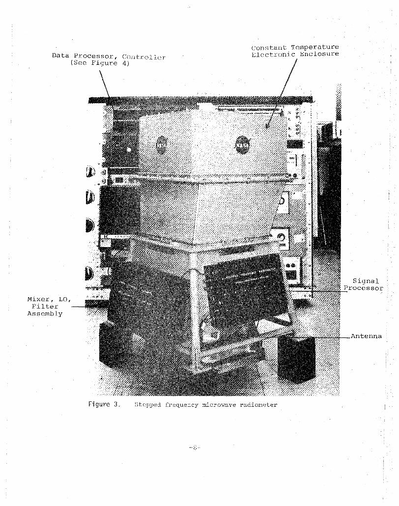
Data Processor, Controller (See Figure 4)
Mixer, LO, Filter
Assembly
Constant Temperature Electronic Enclosure
Figure 3. frequency microvJave radiometer
Signal Processor
Antenna

! \.0
Fi gtwe 4. Front panel view of the digital controller for the stepped frequency microwave radiometer
from the brightness temperature observed by the SFMR at the ice
edge with the in-situ sea surface temperature.. Wind speed and
sea surface salinity were taken into account in the calculation
of sea surface temperature from brightness temperature. The
ideal radiometer brightness temperature sensitivity of the in
strument varies between 0.012K and 1.25K depending on the band
width and integration time selected for the SFMR. The measured
radiometer sensi ti vi ty at 6.6 GEIz was between O. 69K and ,0.8 8K
with a 90% confidence and between 0.65K and 0.94K with a 99%
confidence. The ideal radiometer sensitivity for the above case
was 0.25K. The radiometer was operating with a 60 MHz prede
tection filter bandwidth, a 0.2 second post detection integration
time, with 5 samples averaged during post flight data reduction
to achieve a sample period of 1 second.
The SFMR is a balanced Dicke-switched square-wave correlated
radiometer. The radiometer utilizes a closed-loop Type I noise
feedback circuit to add noise to the received antenna noise,
thereby balancing to the Dicke reference noise. The microwave
portion of the radiometer, including the broad band tunnel-diode
low-noise amplifier is maintained in a constant temperature en
closure at the Dicke reference temperature within ± O.lOK. A
block diagram of the radiometer is shown in Figure 5.
The antenna consists of a corrugated wall broadband horn
(10 dB Beamwidth for circular polarization:: 20.50 ) .. The an-
tenna has a polarizing radome to provide for circular polarization.
-10-
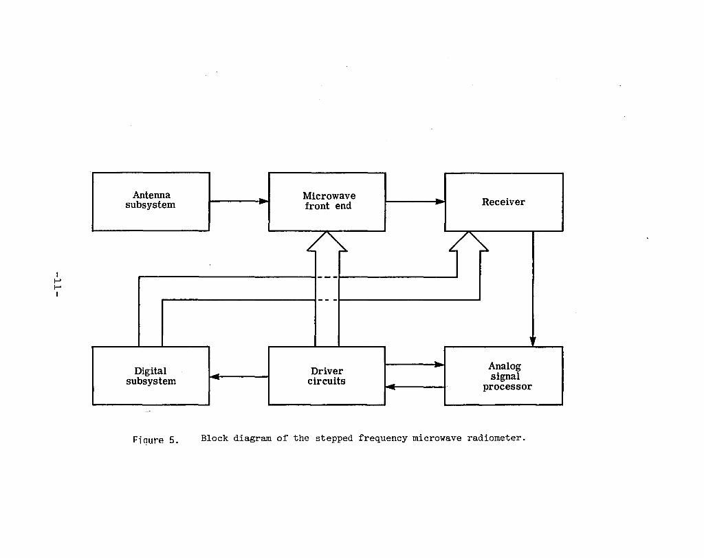
I I-' I-' I
Antenna subsystem
Digital subsystem
Fiollre 5.
Microwave -- Receiver - front end
/ /~ ---
-- -
"
Analog Driver -signal ~ circuits .- processor
I
Block diagram of the stepped frequency microwave radiometer.
An 11 layer fiberglass/honeycomb sandwich radome is used over
the polarizing radome in pressurized aircraft. The feed of the
antenna is located within the constant temperature enclosure.
The noise injection circuit consists of a solid-state noise
diode, isolator, PIN diode switch and 20 dB directional coupler.
The Dicke switch is a broadband latching circulator.
The receiver portion of the radiometer consists of a homo
dyne mixer, YIG tuned local oscillator and 1 to 1000 megahertz
IF amplifier. The frequency of the radiometer is controlled by
an eight bit digital word from the digital subsystem that is
converted to a 0 to 10 volt dc voltage. This signal controls
the voltage tuned microwave oscillator. The frequency can be
changed every 200 milliseconds in steps of 16 MHz or greater
over the frequency range from 4.018 GHz to 8.098 GHz. However,
the antenna limits the useable frequency range to 4.500 GHz to
7.200 GHz. The bandwidth of the radiometer is selected by the
digital subsystem using one of four paths through the filter
bank.
The 1 to 1000 MHz constant power level noise signal is
transformer coupled into a hot-carrier diode square-law detec
tor in the analog signal processor. The detected noise signal
is amplified, synchronously detected with the Dicke switching
frequency and the resultant error signal is fed to a true in
tegrator. The output of the integrator is filtered to remove
the effect of the Dicke switching frequency and used to control
the pulse train output of a voltage-to-frequency (V/F) converter.
-12-
The V/F converter provides a variable duty cycle 70 TIlicro
second pulse train. The pulse repetition frequency varies from
o to 10,000 pulses per second linearly with the dc output vol
tage of the integrator. This pulse train is applied to the
noise injection PIN diode switch and controls the number of in
jected constant amplitude, constant width noise pulses. The
digital subsystem measures the duty cycle of the pulse train to
determine the noise added to the antenna noise.
The digital subsystem provides both control functions to
the radiometer, data processing of the output signal from the
radiometer and physical temperature measurements of several lo
cations in the radiometer. It also provides front panel control
functions and real-time displays for the operator. The radio
meter data are formatted along with time, temperatures and other
operational data, and are recorded on a digital tape recorder.
An estimate of the brightness temperature is computed by the
microprocessor and displayed to the operator (Reference 18).
The integration time of the radiometer is determined by the
count period of the injection time counters which compute the
duty cycle of the radiometer output. The integration time of
the closed-loop radiometer noise feedback is several times faster
than the minimum integration time allowed by the digital sub
system.
-13-
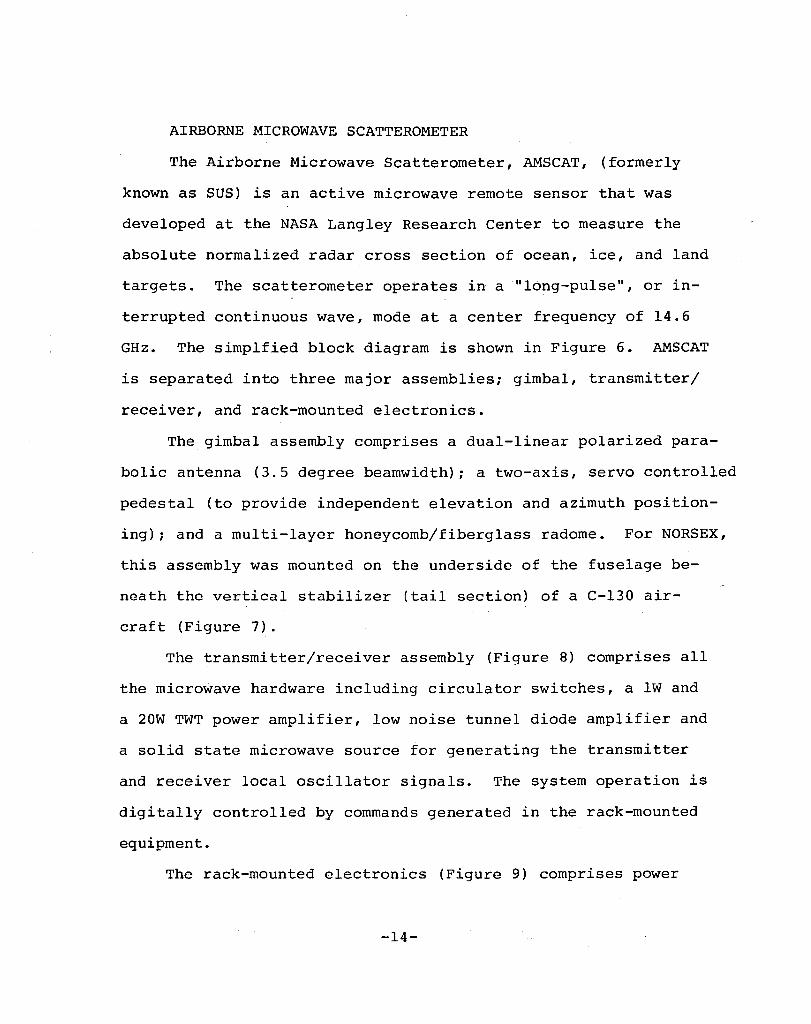
AIRBORNE MICROWAVE SCATTEROMETER
The Airborne Microwave Scatterometer, AMSCAT, (formerly
known as SUS) is an active microwave remote sensor that was
developed at the NASA Langley Research Center to measure the
absolute normalized radar cross section of ocean, ice, and land
targets. Thescatterometer operates in a "long-pulse", or in
terrupted continuous wave, mode at a center frequency of 14.6
GHz. The simplfied block diagram is shown in Figure 6. AMSCAT
is separated into three major assemblies; gimbal, transmitter/
receiver, and rack-mounted electronics.
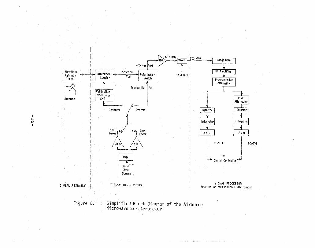
The gimbal assembly comprises a dual-linear polarized para
bolic antenna (3.5 degree beamwidth)i a two-axis, servo controlled
pedestal (to provide independent elevation and azimuth position
ing) i and a multi-layer honeycomb/fiberglass radome. For NORSEX,
this assembly was mounted on the underside of the fuselage be
neath the vertical stabilizer (tail section) of a C-130 air-
craft (Figure 7).
The transmitter/receiver assembly (Figure 8) comprises all
the microwave hardware including circulator switches, a lW and
a 20W TWT power amplifier, low noise tunnel diode amplifier and
a solid state microwave source for generating the transmitter
and receiver local oscillator signals. The system operation is
digitally controlled by commands generated in the rack-mounted
equipment.
The rack-mounted electronics (Figure 9) comprises power
-14-
I f-J Ul
GIMBAL ASSEMBLY
Figure 6.
Antenna Port
Transm itter I Port
Solid State Source
Operate
1 zoo MHz
I I
14.4 GHz I
SCAT-l SCAT-Z
to
Digital Controller
SIGNAL PROCESSOR TRftNSMITTER-RECEIVER (Port ion of rack-mou nted electron ics)
Simplified Block Diagram of the Airborne Microwave Scatterometer
AMSCArr Antenna
(less feed and Radorne)
Figure 7. Scatterometer Gimbal Assembly on C-130 Aircraft
Figure 8. Scatterometer Transmitter/Receiver Assembly
-16-
Signal Processor
Digital Controller
Gimbal Controller
Power Supplies
Oscilloscope
Digital Tape Recorder
Interface f--..-- Panel
Figure 9. Rack-Mounted Electronics for Scatterometer
-17-
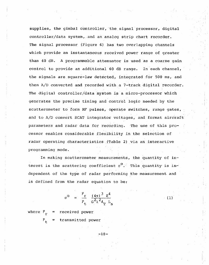
supplies, the gimbal controller, the signal processor, digital
controller/data system, and an analog strip chart recorder.
The signal processor (Figure 6) has two overlapping channels
which provide an instantaneous received power range of greater
than 40 dB. A programmable attenuator is used as a coarse gain
control to provide an additional 60 dB range. In each channel,
the signals are square-law detected, integrated for 500 ms, and
then A/D converted and recorded with a 7-track digital recorder.
The digital controller/data system is a micro-processor which
generates the precise timing and control logic needed by the
scatterometer to form RF pulses, operate switches, range gates,
and to A/D convert SCAT integrator voltages, and format aircraft
parameters and radar data for recording. The use of this pro-
cessor enables considerable flexibility in the selection of
radar operating characteristics (Table 2) via an interactive
programming mode.
In making scatterometer measurements, the quantity of in
terest is the scattering coefficient 00
• This quantity is in-
dependent of the type of radar performing the measurement and
is defined from the radar equation to be:
where P r =
=
= p
r
received power
transm~tted power
-18-
(1)
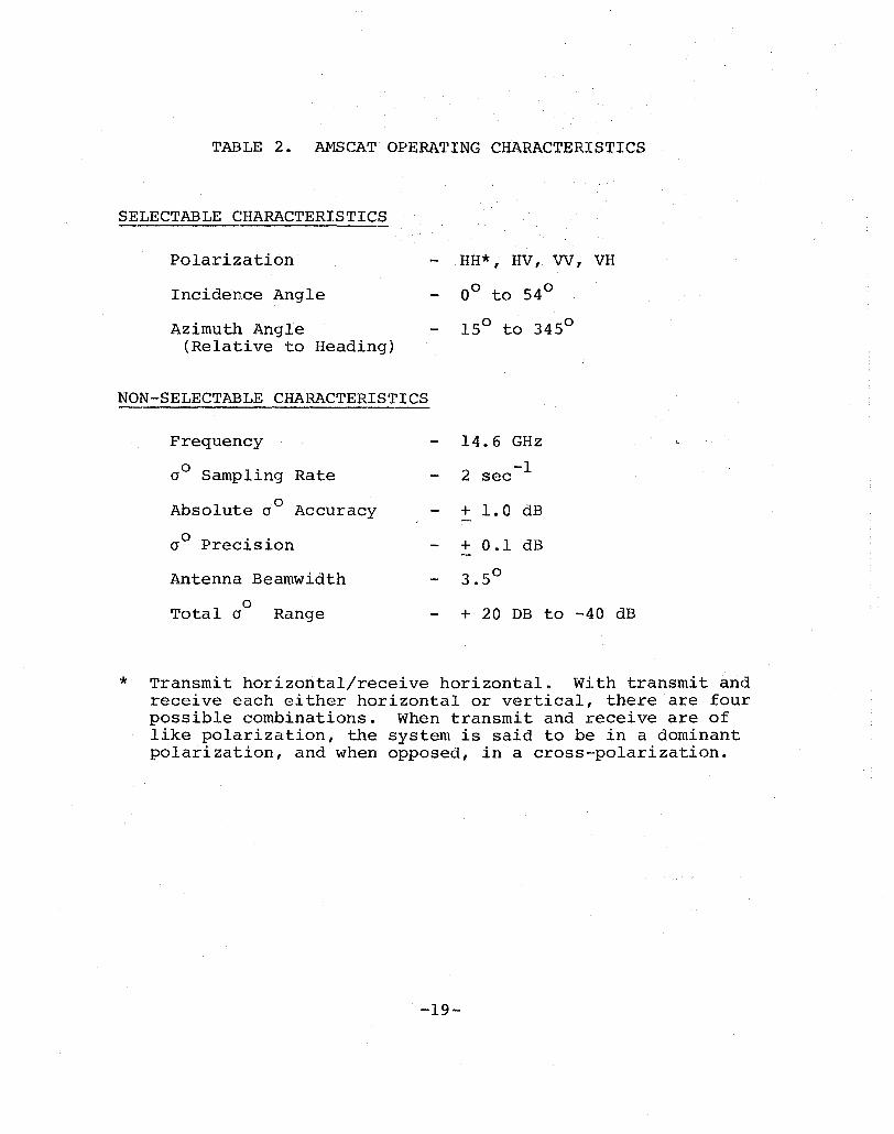
TABLE 2. AMSCAT OPERATING CHARACTERISTICS
SELECTABLE CHARACTERISTICS
Polarization
Incidence Angle
Azimuth Angle (Relative to Heading)
HH*, HV, VV, VH
00 to 54 0
150 to 3450
NON-SELECTABLE CHARACTERISTICS
*
Frequency
aO Sampling Rate
Absolute aO Accuracy
o P .. a reC1Slon
Antenna Beamwidth
o Total a Range
14.6 GHz
-1 2 sec
+ 1.0 dB
+ 0.1 dB
3.50
+ 20 DB to -40 dB
Transmit horizontal/receive horizontal. With transmit and receive each either horizontal or vertical, there are four possible combinations. When transmit and receive are of like polarization, the system is said to be in a dominant polarization, and when opposed, in a cross-polarization.
-19-
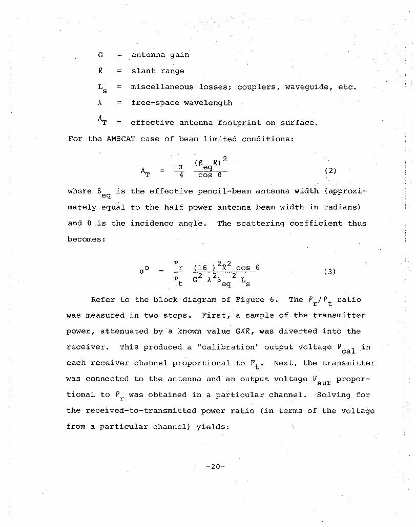
G = antenna gain
R = slant range
LS = miscellaneous losses; couplers, waveguide, etc.
A = free-space wavelength
AT = effective antenna footprint on surface.
For the AMSCAT case of beam limited conditions:
= (2)
where e is the effective pencil-beam antenna width (approxieq
mately equal to the half power antenna beam width in radians)
and a is the incidence angle. The scattering coefficient thus
becomes:
= (3)
Refer to the block diagram of Figure 6. The Pr/Pt ratio
was measured in two steps. First, a sample of the transmitter
power, attenuated by a known value GXR, was diverted into the
receiver. This produced a "calibration" output voltage V I in ca
each receiver channel proportional to Pt - Next, the transmitter
was connected to the antenna and an output voltage Vsur propor
tional to P was obtained in a particular channel. Solving for r
the received-to-transmitted power ratio (in terms of the voltage
from a particular channel) yields:
-20-
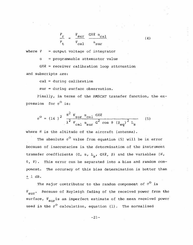
P V GXR a cal r sur (4) = --------Pt V cal a sur
where V = output voltage of integrator
a = programmable attenuator value
GXR = receiver calibration loop attenuation
and subscripts are:
cal = during calibration
sur = during surface observation.
Finally, in terms of the AMSCAT transfer function, the ex
pression for 00 is:
H2 V a GXR sur cal (5)
where H is the altitude of the aircraft (antenna).
The absolute 00 value from equation (5) will be in error
because of inaccuracies in the determination of the instrument
transfer coefficients (G, a, L , GXR, S) and the variables (H, s
s, V). This error can be separated into a bias and random com-
ponent. The accuracy of this bias determination is better than
+ 1 dB.
The major contributor to the random component of 00 is
V sur Because of Rayleigh fading of the received power from the
surface, V is an imperfect estimate of the mean received power sur
used in the 0° calculation, equation (1) e The normalized
-21-
standard deviation of the cross section is approximately:
(6)
where N = number of independent samples,
N = (7)
where T = integration time
and Sd = Doppler bandwidth of received power,
= 2Vf (sin e - sin e ) -C- max min (8)
Here V = aircraft speed
f = radar frequency
C = speed of light
F th NO S .. A 0/ 0 1 th 0 5 dB or e R EX mlSS10n uO 0 was ess an + .
After the conclusion of the field phase of NASA's partici-
pation in the NORSEX program, an intermittent contact was found
in the polarization change-over switch of the scatterometer.
The effect of this condition is that much of the scatterometer
data intended as HH (see Table 2) polarization was discovered
later to be actually either HV or some mixture of HH and HV.
This results in an uncertainty of several dB in absolute level
of the HH, HV and VH data. The VV data are not affected.
-22-
PRECISION RADIATION THERMOMETER
The Precision Radiation Th~rmometer, referred to as the
PRT-5, is a nadir-looking infrared radiometer used to remotely
measure physical temperature of targets. The output of the PRT-5
is available on the nine-track digital tapes as surface tempera
ture in degrees Celsius. Table 3 summarizes the operating char
acteristics of the instrument used during the NORSEX mission.
The user should consult reference 21 for a complete description
of the instrument.
-23-

TABLE 3. PRT-S OPERATING CHARACTERISTICS
Performance Data
Temperature Measurement Range (oC)
Accuracy
Sensitivity (@ 2SoC)
Filter Band
Field of view
-24-
-3S
8
to + 7So C
D.SoC
D.loC
- 14 microns
2°
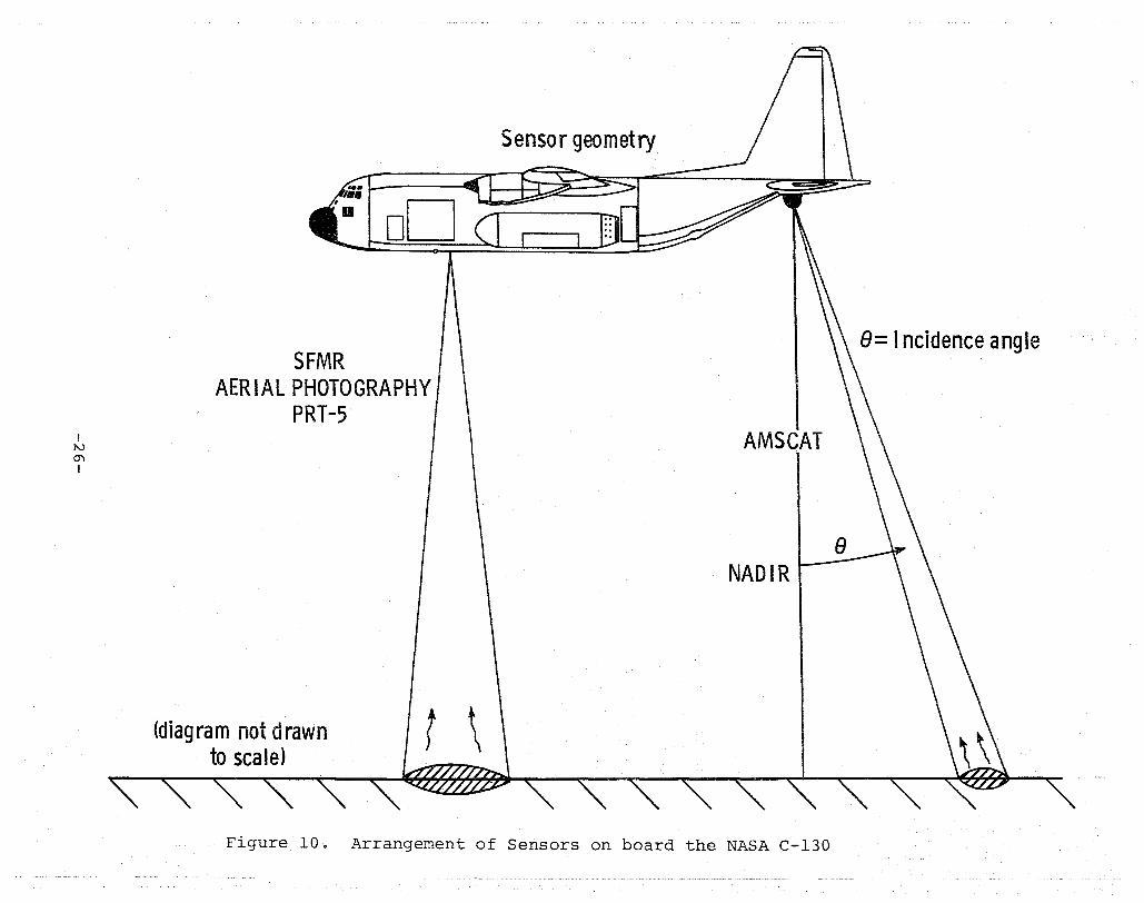
SECTION 3
SENSOR GEOMETRY
In order to make use of the data obtained during NORSEX 79,
an understanding of sensor geomet:ry and its effects on temporal
and spatial alignment of the data is required. Figure 10 illus
trates the arrangement of sensors on board the NASA C-130 air
craft during the NORSEX mission. The Stepped Frequency Micro
wave Radiometer (SFMR), PRT-5 and aerial cameras are nadir look
ing instruments, hence, the footprints of these instruments were
directly beneath the aircraft. The Airborne Microwave Scattero
meter (AMSCAT) I however, operated at a variety of incidence
angles from 0 0 to 54 0 and was aimed behind the aircraft. For
an incidence of 00 the AMSCAT was nadir-looking, however, as the
incidence angle increases the AMSCAT footprint is translated
backward along the flight line. Therefore, the SFMR, PRT-5 and
aerial cameras will image an area before the AMSCAT. As stated
previously, all sensors have been referenced to Greenwich Meri
dian Time (GMT). This requires that a temporal correction be
applied by the user to the AMSCAT data in order to align the
data from all sensors. This correction is as follows:
AMSCAT time (GMT) .- NADIR time (GMT) + ~t
where ~t is a function of aircraft altitude, speed and the inci
dence angle of the AMSCAT. The temporal offset (~t) can be
-25-
I I\J 0"1 I
SFMR AERIAL PHOTOGRAPHY
PRT-5
(diag ra m not drawn to scale)
Sensor geometry
AMSCAT
Figure 10. Arrangement of Sensors on board the NASA C-130
8= I ncidence angle
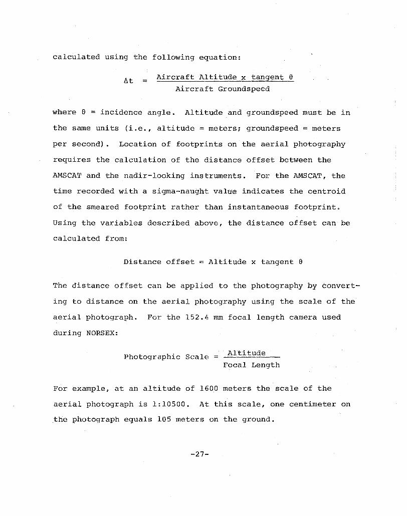
calculated using the following equation:
ht = Aircraft Altitude x tangent e Aircraft Groundspeed
where e = incidence angle. Altitude and groundspeed must be in
the same units (i.e., altitude = meters; groundspeed = meters
per second). Location of footprints on the aE~rial photography
requires the calculation of the distance offset between the
AMSCAT and the nadir-looking instruments. For the AMSCAT, the
time recorded with a sigma-naught value indicates the centroid
of the smeared footprint rather than instantaneous footprint.
Using the variables described above, the distance offset can be
calculated from:
Distance offset = Altitude x tangent e
The distance offset can be applied to the photography by convert
ing to distance on the aerial photography using the scale of the
aerial photograph. For the 152.4 mm focal length camera used
during NORSEX:
Photographic Scale = ATtitude
Focal Length
For example, at an altitude of 1600 meters the scale of the
aerial photograph is 1:10500. At this scale, one centimeter on
the photograph equals 105 meters on the ground.
-27-
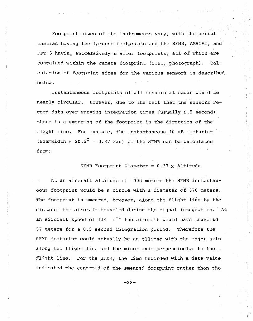
Footprint sizes of the instruments vary, with the aerial
cameras having the largest footprints and the SFMR, AMSCAT, and
PRT-5 having successively smaller footprints, all of which are
contained within the camera footprint (i.e., photograph). Cal-
culation of footprint sizes for the various sensors is described
below.
Instantaneous footprints of all sensors at nadir would be
nearly circular. However, due to the fact that the sensors re-
cord data over varying integration times (usually 0.5 second)
there is a smearing of the footprint in the direction of the
flight line. For example, the instantaneous 10 dB footprint
(Beamwidth = 20.50 = 0.37 rad) of the SFMR can be calculated
from:
SFMR Footprint Diameter = 0.37 x Altitude
At an aircraft altitude of 1000 meters the SFMR instantan-
eous footprint would be a circle with a diameter of 370 meters.
The footprint is smeared, however, along the flight line by the
distance the aircraft traveled during the signal integration. At
an aircraft speed of 114 ms- l the aircraft would have traveled
57 meters for a 0.5 second integration period. Therefore the
SFMR footprint would actually be an ellipse with the major axis
along the flight line and the minor axis perpendicular to the
flight line. For the SFMR, the time recorded with a data value
indicated the centroid of the smeared footprint rather than. the
-28-
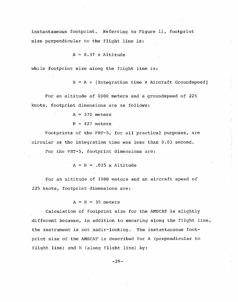
instantaneous footprint. Referring to Figure 11, footprint
size perpendicular to the flight line is:
A == 0.37 x Altitude
while footprint size along the flight line is:
B == A + [Integration time x Aircraft Groundspeed]
For an altitude of 1000 meters and a groundspeed of 225
knots, footpri.nt dimensions are as follows:
A == 370 meters
B == 427 meters
Footprints of the PRT-5, for all practical purposes, are
circular as the integration time was less than 0.03 second.
For the PRT-5, footprint dimensions are:
A == B == .035 x Altitude
For an altitude of 1000 meters and an aircraft speed of
225 knots, footprint dimensions are:
A == B == 35 meters
Calculation of footprint size for the AMSCAT is slightly
different because, in addition to smearing along the flight line,
the instrument is not nadir-looking. The instantaneous foot
print size of the AMSCAT is described for A (perpendicular to
flight line) and B (along flight line) by:
-29--
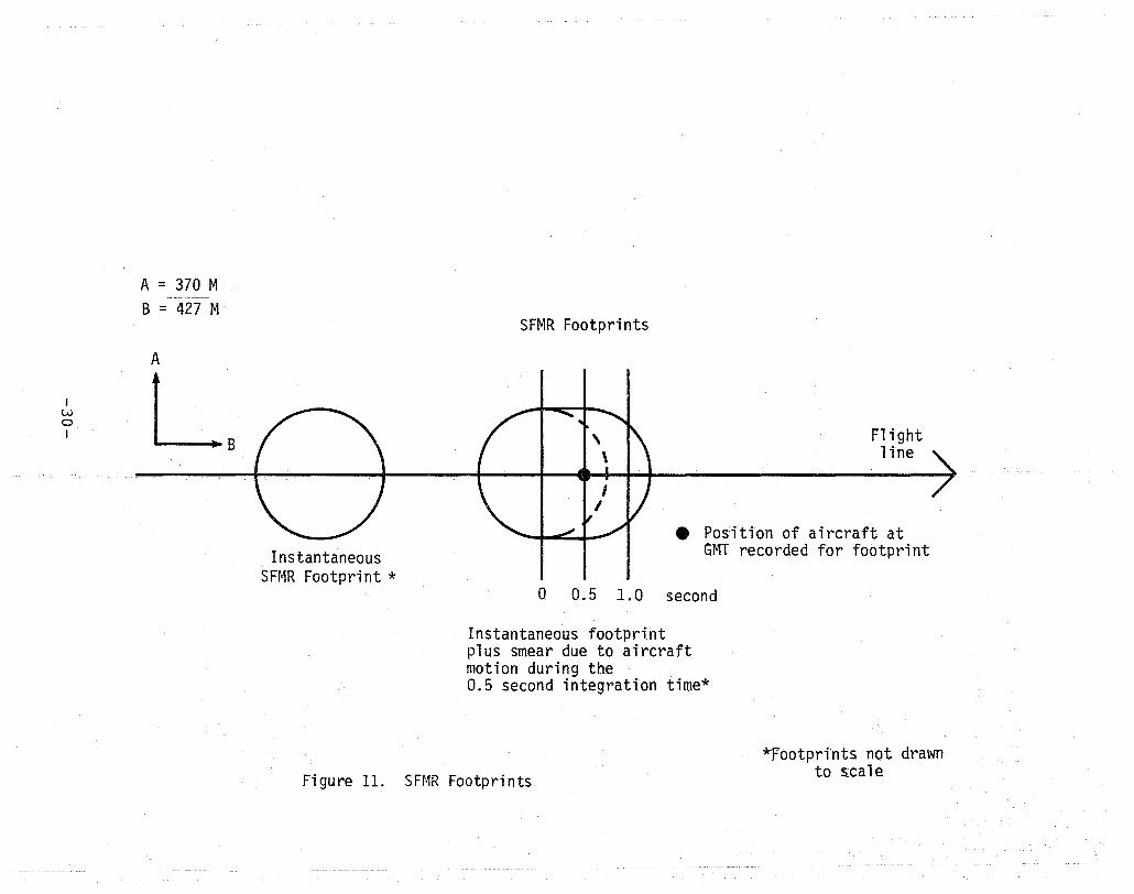
I w o I
A = 370 M
B = 427 M
A
LB Instantaneous
SFMR Footprint *
SFrvlR Footprints
Flight 1 ine
• Position of aircraft at GMT recorded for footprint
o Q.5 1.0 second
Instantaneous footprint plus smear due to aircraft motion during the 0.5 second integration time*
Figure 11. SFMR Footprints *Footprints not drawn
to s~cale
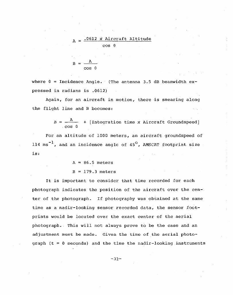
A = .0612 X Aircraft Altitude
cos 8
B = A
cos 8
where 8 = Incidence Angle. (The antenna 3.5 dB beamwidth ex-
pressed in radians is .0612)
Again, for an aircraft in motion, there is smearing along
the flight line and B becomes:
B = A + [Integration time ~ Aircraft Groundspeed] cos 8
For an altitude of 1000 meters, an aircraft groundspeed of
114 ms-l , and an incidence angle of 45 0, AMSCAT footprint size
is:
A = 86.5 meters
B = 179.3 meters
It is important to consider that time recorded for each
photograph indicates the position of the aircraft over the cen-
ter of the photograph. If photography was obtained at the same
time as a nadir-looking sensor recorded data, the sensor foot-
prints would be located over the exact center of the aerial
photograph. This will not always prove to be the case and an
adjustment must be made. Given the time of the aerial photo-
graph (t = 0 seconds) and the time the nadir-looking instruments
-3~-

recorded data (t = +1 seconds), the sensor footprints will be
located "ahead" of the center of the aerial photograph, relative
to the direction of travel. -1 At a speed of 114 ms ,the center
of the nadir-looking sensor footprints would be approximately
114 meters "ahead" of the center of the photograph. At a photo-
graphic scale of 1:10500 the footprint would be approximately
1.1 cm "ahead" of the center of the photograph for a 1 second
time difference. Likewise, for photograph time = 0 and sensor
time = -1 second, the sensor footprint would be located 114
meters "behind" the center of the photograph, again relative to
the direction of travel.
After the centers of the nadir-looking sensors have been
located on the aerial photograph, the AMSCAT footprints may be
located using the distance and time offsets as calculated above.
After footprint sizes have been calculated for the various
sensors at the appropriate altitudes, groundspeeds, incidence
angles and integration times, templates of the footprints may be
drawn at the scale of the photography for that section and trans
ferred to clear acetate sheets. The acetate sheets can then be
overlaid on the aerial photography a~d used to locate footprints.
In summary, the process of locating microwave footprints
on aerial photograph is as follows:
1) Calculate time and distance offsets for AMSCAT relative
to SFMR and PRT-5 (AMSCAT time = Nadir time + ~t) .
2) Calculate footprint sizes for SFMR, PRT-5 and AMSCAT.
-32-
3) Draw template of sensor footprints at scale of
appropriate photography.
4) Locate center of photograph.
5) Determine if nadir-looking sensor footprints (SFMR;
PRT-S) are located "behind" or "ahead" of center of
photograph.
6) Calculate distance offset between center of aerial
photograph and sensor footprint.
7) Center footprint templates for SFMR and PRT-S along
the flight line.
8) Use distance offset calculated for AMSCAT to locate
AMSCAT footprint behind SFMR and PRT-S footprints.
9) Identify ice types within each footprint and corre
late with remote sensing data.
-33--

SECTION 4
NORSEX' DATA SET' SUMMAHY
This Section summarizes all of the remote sensing data ob
tained by NASA Langley Research Center during the 1979 Norwegian
Remote Sensing Experiment (NORSEX). These data are available on
digital computer tapes (See Appendix B) •
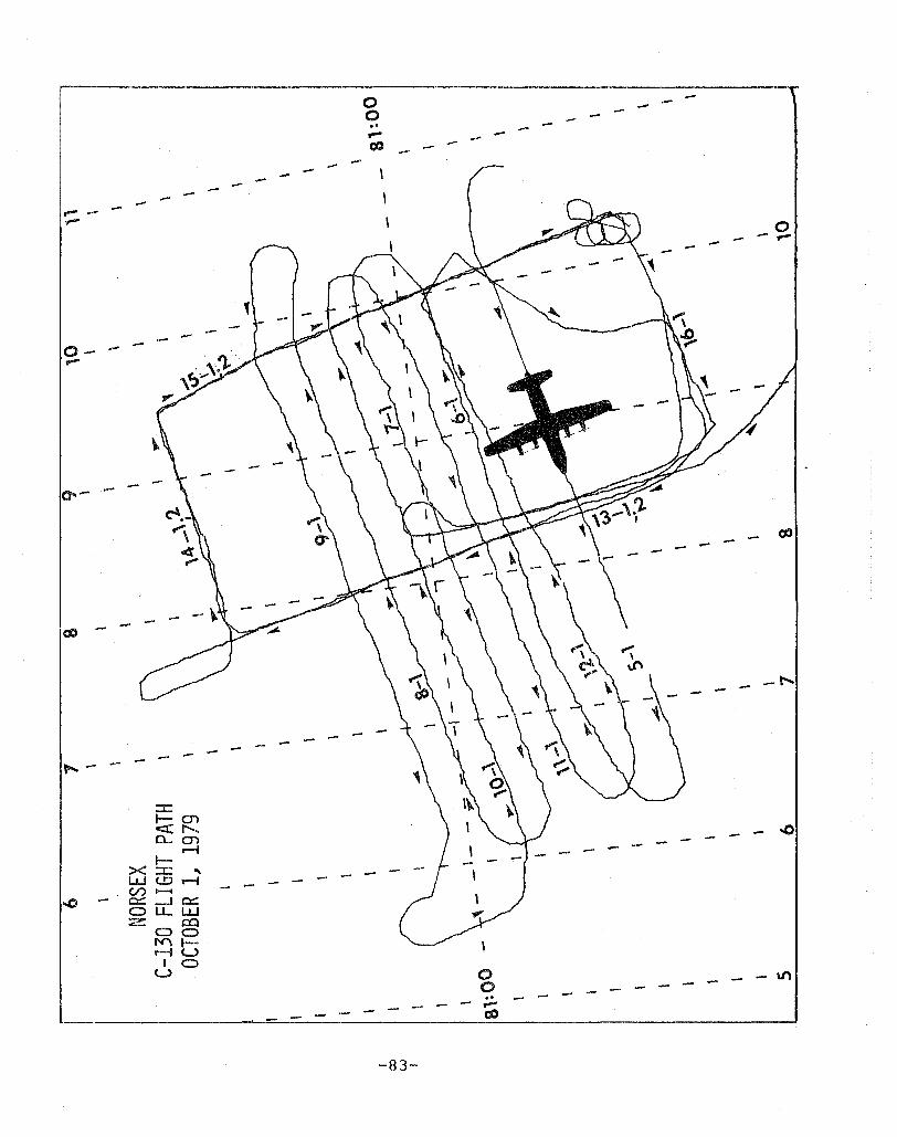
Data were obtained for six days during the period of Sep
tember 29 - October 19, 1979, and are referenced by Julian Day.
Flight line plots are presented for each day (Appendix C). The
first plot indicates the geographic location of all flight lines
for the entire day, which includes the area of the Polar Front
and the Marginal Ice Zone. The second plot is an enlarged plot
of flight lines only in the vicinity of the Marginal Ice Zone.
Because the primary objective of NORSEX 79 was the acquisition of
data over sea ice, flight lines corresponding to the annotated
flight lines and runs are located only near the Marginal Ice Zone.
Data for the Polar Front and other areas were obtained and are
also included in the time line plots for each day.
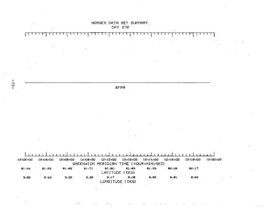
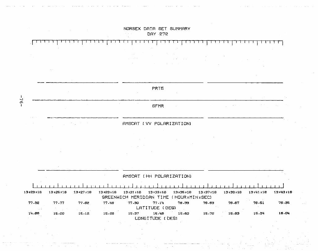
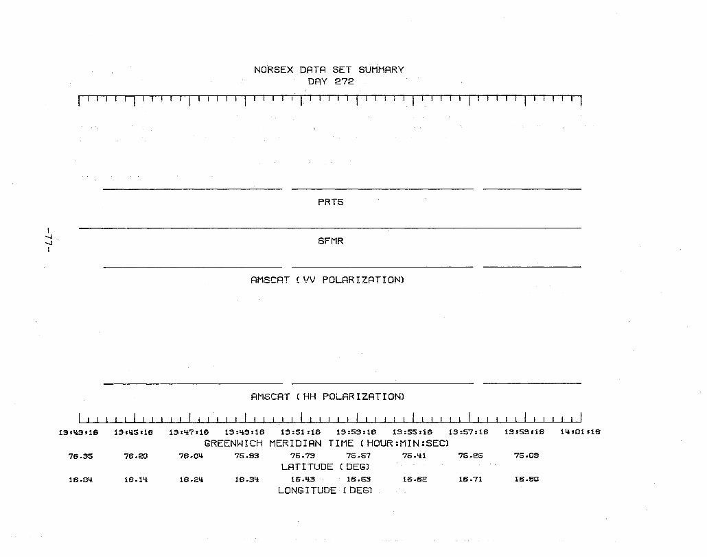
The time-line plots for each day were made showing when
sensors were recording data~ The time-line plots are referenced
to Greenwich Meridian Time (GMT), which is also the local time.
The corresponding Latitude and Longitude are also shown. The
plots will enable a user to select data for detailed analysis
based ,upon the need for a particular sensor configuration and/or
-34-
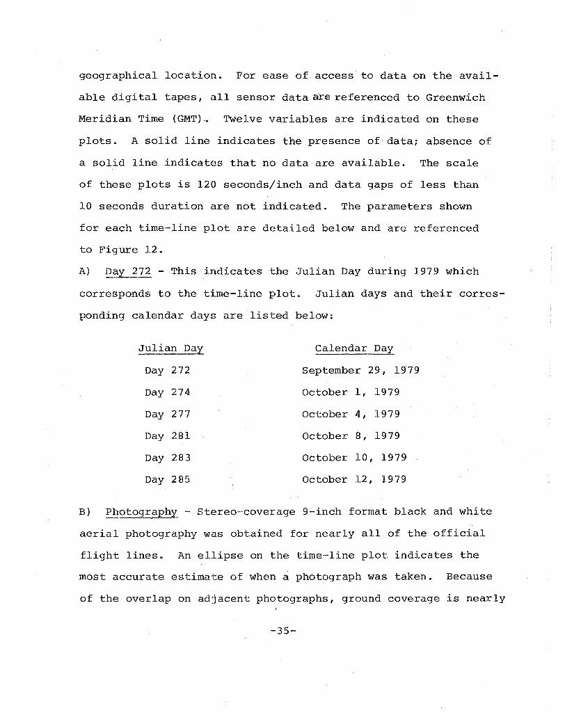
geographical location. For ease of access to data on the avail
able digital tapes, all sensor data are referenced to Greenwich
Meridian Time (GMT) -0 Twelve variables are indicated on these
plots. A solid line indicates the presence of data; absence of
a solid line indicates that no data are available. The scale
of these plots is 120 seconds/inch and data gaps of less than
10 seconds duration are not indicated. The parameters shown
for each time-line plot are deta.iled below and are referenced
to Figure 12.
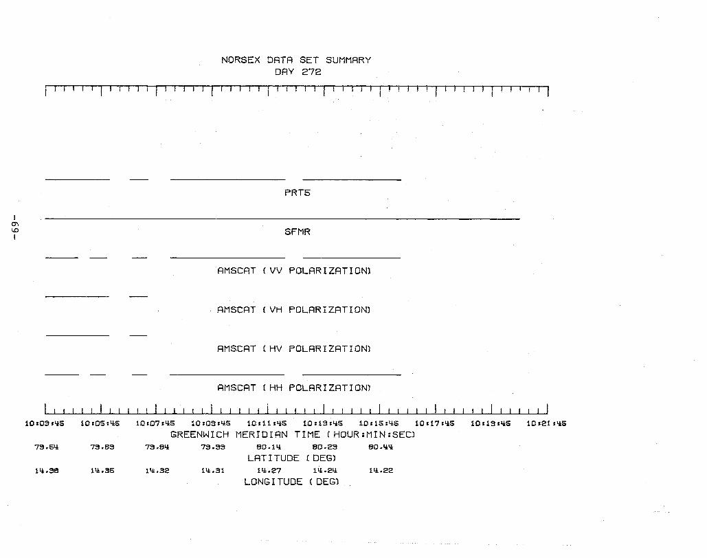
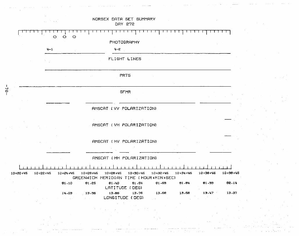
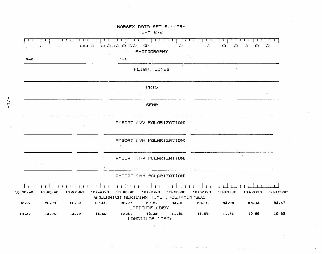
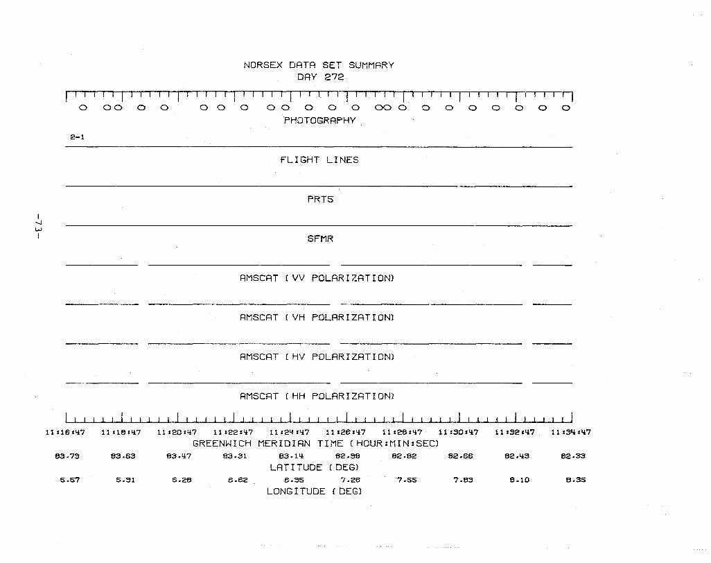
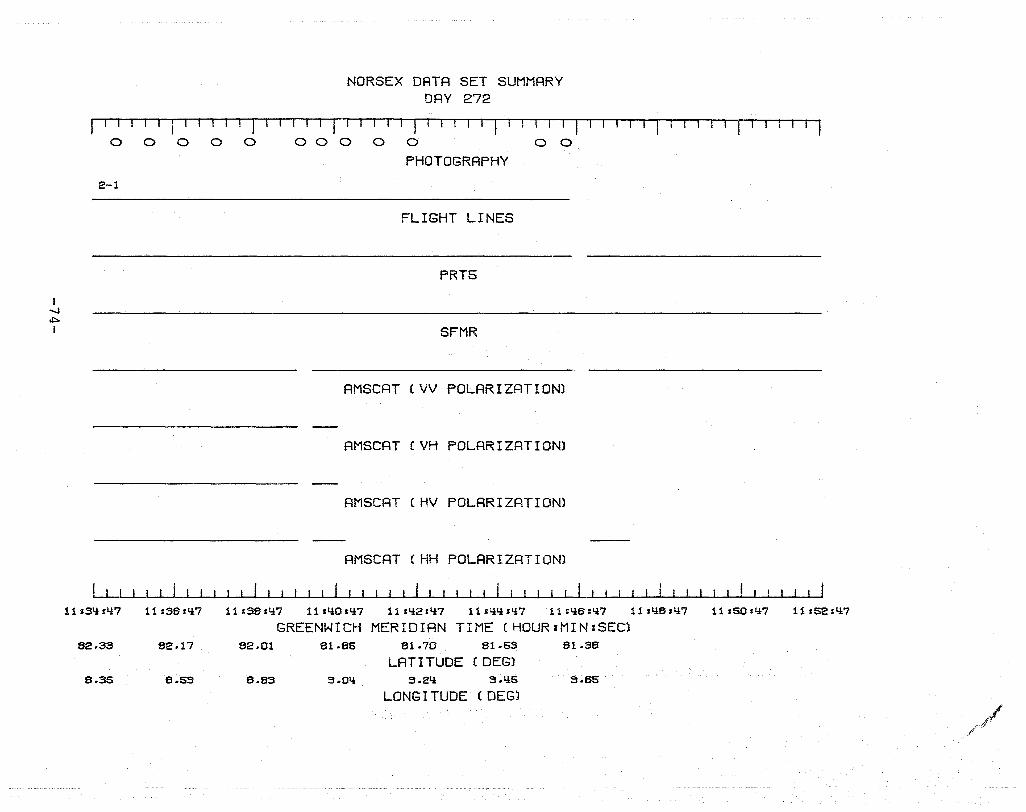
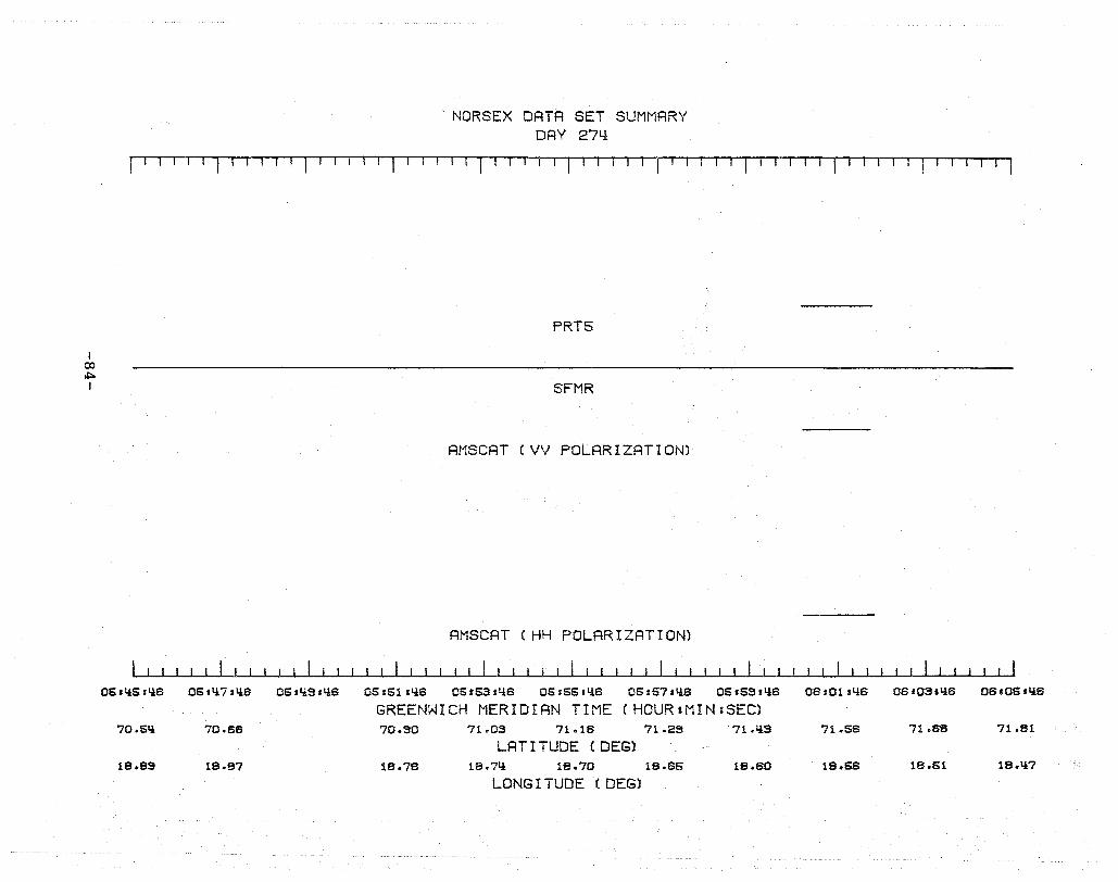
A) Day 272 - This indicates the Julian Day during 1979 which
corresponds to the time-line plot. Julianda.ys and their corres
ponding calendar days are listed below:
Julian Day Calendar Day
Day 272 September 29, 1979
Day 274 October 1, 1979
Day 277 October 4, 1979
Day 281 October 8, 1979
Day 283 October 10, 1979
Day 285 October 12, 1979
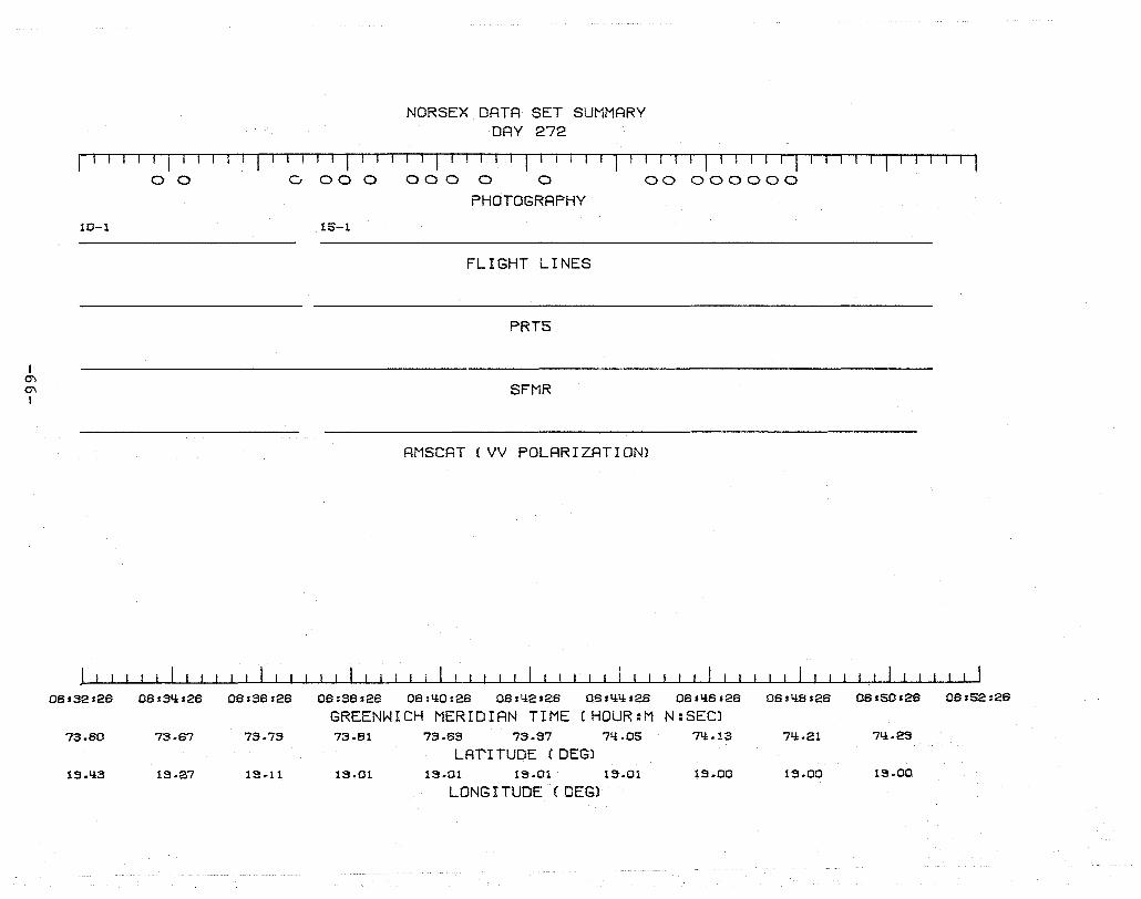
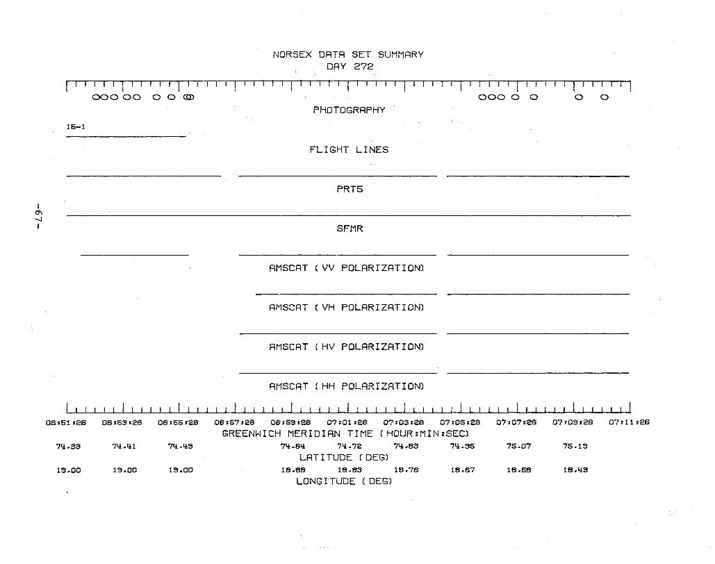
B) Photogra;ehy - Stereo-coverage 9-inch format black and white
aerial photography was obtained for nearly all of the official
flight lines. An ellipse on the time-line plot indicates the
most accurate estimate of when a photograph was taken. Because
of the overlap on adjacent photographs, ground coverage is nearly
-35-

I w 0"1 I
A NORSEX DATA SET SUMMARY
DAY 272
f' I liT I r I r f I I 11 I I I ,- fl I· r 1
B. o 00 o
2-1 c.
D
E
F
G
H
I
J l1s18'li7 11r18sli7
K 83.75 83.83
L 5.57 5.S1
o
11s20sli7
o 0 o 00 0 0 0
PHOTOGRAPHY
FLIGHT LINEl?
PRT5
SFMR
00 0
AMSCAT (VV POLARIZATION)
AMSCAT (VH POLARIZATION)
AMSCAT (HV POLARIZATION)
AMSCAT (HH POLARIZATION)
o
11s22sl!7 11 s21i sll7 11s2B'li7 11 ,28.li7
o o
Data7
11sS0.li7
GREENWICH MERIDIAN TIME (HOUR:MIN:SEC) 83.ll7 83.31 S3.Ill 62.36 82.82 62.66
LAT I TUDE (DEG) 6.2B 6.62 6.S5 7.26 7.55 7.83
LONG I TUDE (DEG) Figure 12. Time Line Plot
o o o o
(NO data
I 11 sS2sli7 11sSlisll7
62.liS 62.33
B.I0 B.35
continuous, however, during the middle of some flight lines,
extensive cloud cover beneath the aircraft prevented the acqui
sition of usable photography. Since only a limited amount of
film was carried on board the aircraft, the camera operator
manually turned off the camera over extensive cloud cover and
turned it on again when openings appeared. Consequently, there
are gaps in the photographic record of some flight lines. A
complete inventory of all available aerial photography is pre
sented in Appendix A.
C) Flight Lines - A solid line indicates whether or not the
data were obtained during an official flight line. The number
i.e., 2-1) refers to the flight line and run number. Geographic
locations of the official flight lines for each day are plotted
at the beginning of data for each day. Furthermore, aerial
photography is inventoried (Appendix A) for ea.ch day according
to its flight line and run, as well as by GMT. Data obtained
other than during an official flight line may not be usable.
These data are presented here for the sake of completeness and
for their considerable value as an historical data base.
D) PRT-5 - This indicates when the Infrared Radiometer was
taking data. This sensor remotely senses the physical tempera
ture of the earth's surface.
E) SFMR - A solid line indicates whether the Stepped Frequency
Microwave Radiometer acquired Brightness Temperatures (TB).
During this study the SFMR operated only at a frequency of 6.6
GHz.
-37·-
F - 1) AMSCAT( x X Polari'zatibn) -A solid line shows whether ( .
the Airborne Microwave Scatterometer was on, and at what polari-
zations it was operating. For example, VH Polarization indicates
that AMSCAT transmitted at vertical (V) polarization and received
at horizontal (H) polarization. Likewise HH Polarization indi-
cates horizontal transmit and horizontal receive.
J) Greenwich Meridian' Tiine(H:M:S) - All data are referenc;ed
to GMT. Available computer tapes can be easily accessed by
searching for the start and stop times of desired data segments.
K - L) Latitude/Longitude - Approximate latitude and longitude
plotted in hundredths of a degree every 2 minutes along the
flight line. Flight lines for each day are also plotted.
-38-
SECTION 5
NORSEX DATA EXAMPLE
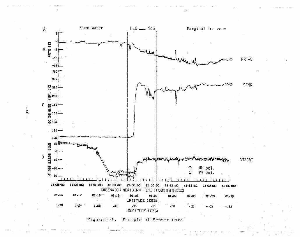
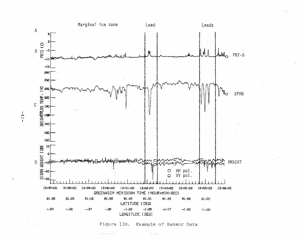
Figures 13 A and B are examples of sensor data recorded on
digital data tapes. All data can be referenced by Greenwich
Meridian Time (GMT) as well as by Latitude and Longitude. Data
shown in this example were selected from the time-line plots of
NORSEX Day 281, Line 1 - Run I and were accessed on the tapes
by searching for a given start and stop time. Only four vari
ables are plotted here, however, there are many more variables
recorded on the digital ta.ees (See Appendix B). Choice of vari
ables to examine will depend upon the particular requirements of
the user.
This example was selected because it includes remote sens
ing data obtained for a variety of representative ice and water
features. The data were obtained along a transect as the air
craft passed over the open ocean and headed into the Marginal
Ice Zone. Aerial photography is available for this example and
was used as surface truth to identify ice features which could
be correlated to the remote sensing data. Because the data for
the sensors have been temporally aligned, statistical techniques
could be employed to extract microwave signatures for ice types
at various concentrations. As mentioned previously, ancillary
oceanographic field data are available to supplement the remote
sensing data (See Bibliography). The following section describes
-39-
A 5
Open water . H20 ~ ice Marginal ice zone
G 0
B U') -5 I-0::: a...
-10 o PRT-5 -15
260
2110
52 220 o SFr~R
...., . ~200 lLJ I-
C (f)180 I (f)
lLJ ~ Z 0 !i: 160 I (.!) .....
~ 1110
120
100
ro 10 c
0 I-
D :I: (.!)
5-10 z ~-20 (.!) ..... (f) -30
~ o HH pol. o VV pol.
Af,1SCAT
13.28s00 13s29soo 13.30.00 13.31.00 13,32100 13.33&00 13.311.00 13!35:00 13136aOO 13s37&00 GREENWICH MERIDIAN TIME (HOUR:MIN:SEC)
81.03 81.12 81.16 61.13 81.22 61.2Il 81.27 81.30 EH.33 61.36 LAT I TUDE (DEG)
1.36 1.2Il 1.OS .31 .71 .51 .30 .12 -.03 -.29 LONG I TUDE (DEG)
Figure l3A. Example of Sensor Data
I ~ I-' I
A 51 0 ot-
B IJ') -5 l-ll::: Q..
-10
. ~200 I.I.J I-
C (1)180 (I)
D
'~1'-:t: ; (J) :
~lIWFI 120
tOOL--
Marginal ice zone" Lead Leads
o PRT-5
~~I· ~o SH1R
D~Q\. AMSCAT 0\\
~
lS.S?saa 13338,00 1Sgsgs00 lasQO,OO lS~~llao 13s;2_oo lasqa.oo 13sq~sOO 13'~S300 13j~8s00
GREENWICH MERIDIAN TIME (HOUR:MIN~SEC} Sl.SS Sl.SS Sl.Q2 S1.ltS S1.lie 81.51 61.5Ii 61.56 81.55
LATITUDE (DEG) -.~ -$1t8 -.67 -.ss -1.06 -1.28 -i.tt7 -1.00 -l.SO
LONG I TUDE (DEG)
Figure 13B Q Example of Sensor Data
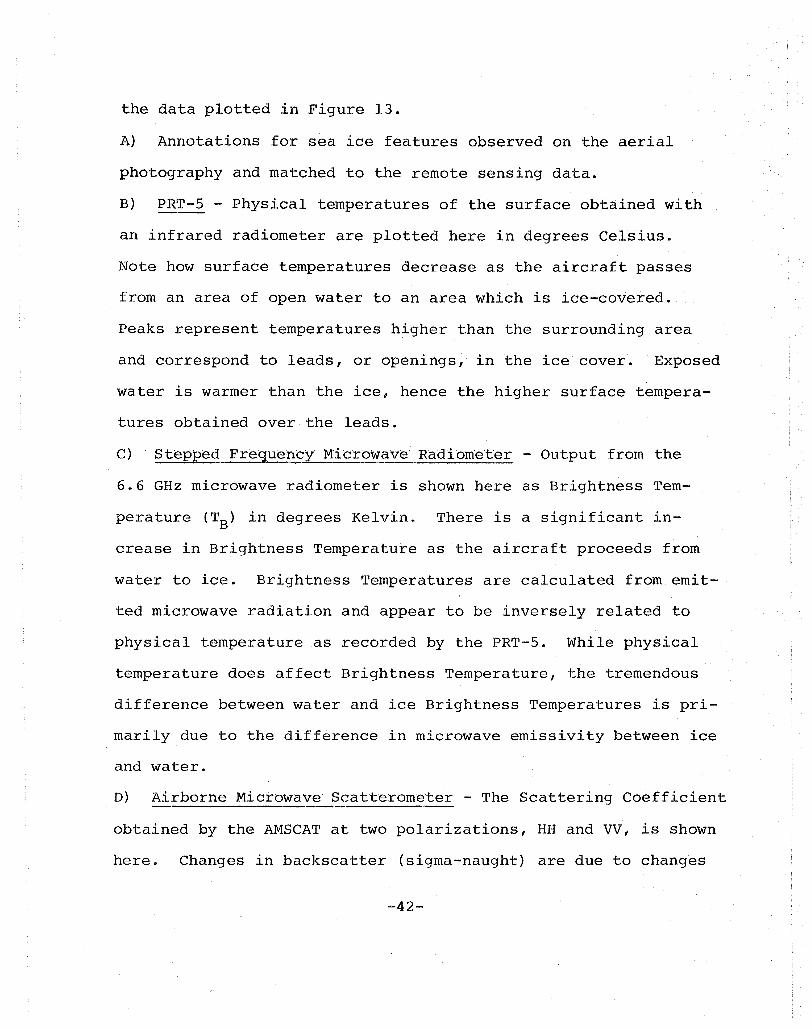
the data plotted in Figure 13.
A) Annotations for sea ice features observed on the aerial
photography and matched to the remote sensing data.
B) PRT-5 - Physical temperatures of the surface obtained with
an infrared radiometer are plotted here in degrees Celsius.
Note how surface temperatures decrease as the aircraft passes
from an area of open water to an area which is ice-covered.
Peaks represent temperatures higher than the surrounding area
and correspond to leads, or openings, in the ice cover. Exposed
water is warmer than the ice, hence the higher surface tempera
tures obtained over the leads.
C) Stepp~d Fregueh..EY.11icrb'Wave Radibllleter - Output from the
6.6 GHz microwave radiometer is shown here as Brightness Tem
perature (TB) in degrees Kelvin. There is a significant in
crease in Brightness Temperature as the aircraft proceeds from
water to ice. Brightness Temperatures are calculated from emit
ted microwave radiation and appear to be inversely related to
physical temperature as recorded by the PRT-5. While physical
temperature does affect Brightness Temperature, the tremendous
difference between water and ice Brightness Temperatures is pri
marily due to the difference in microwave emissivity between ice
and water.
D) Airborne Microwave Scatterometer - The Scattering Coefficient
obtained by the AMSCAT at two polarizations, HH and VV, is shown
here. Changes in backscatter (sigma-naught) are due to changes
-42-
in surface roughness. Generally, low returns indicate a smooth
surface while higher returns indicate a surface with some re
lief. In this example the scatterometer return increased as
the aircraft traveled from an area of relatively smooth water
to relatively rough ice at the Marginal Ice Zone.
This method of visual feature extraction and correlation
with remote sensing data could be performed for other data seg
ments as well. The data and brief qualitative analysis presen
ted here serve only to illustrate one potential use of the data.
No doubt, other, more quantitative methods of analysis are
appropriate using the digital data available on the computer
tapes.
-43-
BIBLIOGRAPHY
GENERAL
1) Campbell, W. J. et al., Beaufort Sea Ice Zones Delineated by Microwave Imagery. ~ Geophys. Res. 81 (6), 1103-1110, 1976.
2) Campbell, W. J., Ramseier, R. 0., Zwally, H. J. and Gloersen, P., Arctic Sea-Ice Variations from Time-Lapse Passive Microwave Imagery. Boundary-Layer Meteorology (18) 99-106, 1980.
3) Campbell, W. J., Weeks, W. F., Ramseier, R. o. and Gloersen, P., Geophysical Studies of Floating Ice by Remote Sensing. ~ Glaciology 15 (73), 305-328, 1975.
4) Campbell, W., Gloersen, P., Zwally, H. J., Ramseier, R. o. and Elachi, C., Simultaneous Passive and Active Microwave Observations of Near-Shore Beaufort Sea Ice. J. Petroleum Technology, 1105-1112, 1980.
5) Gloersen, P., Nordberg, P., Schmugge, T. J., Wilheit, T. T. and Campbell, W. J., Microwave Signature of First-Year and Multiyear Ice. NASA TM-X-66006, 22, 1972.
6) Gloersen, P. and Baroth, F. T., A Scanning Multichannel Microwave Radiometer for Nimbus-G and Seasat-A. IEEE Jrnl. Ocean Engineering, GE-2(2), 172-178, 1977.
7) Jackson, B. L., Jones, W. L. and Stanley, W. D., Measure of Arctic Sea Ice Characteristics Using Microwave Scatterometry. Proceedings of the 1979 IEEE Southeast Conference, pp 278-280.
8) Onstott, R. G., Moore, R. K. and Weeks, W. F., SurfaceBased Scatterometer Results of Arctic Sea Ice. IEEE Trans. Geoscience Electronics. GE-17, (3), 78-85, 1979.
9) Parashar, S. K., Horalich, R. M., Moore, R. K. and Biggs, A. W., Radar Scatterometer Discrimination of Sea Ice Types. IEEE Trans. Geoscience Electronics GE-15 (2) I
83-87, 1977.
10) Rouse, J. W., Arctic Ice Type Identification by Radar. Proc. of the IEEE 57, (4) 1 605-511, 1969.
11) Swift, C. T. et al., Microwave Radar and Radiometric Remote Sensing Measurements of Lake Ice, Geophys. Res., Lett. , .1.' ( 4), 2 4 3 - 2 4 6, 19 80 .
-44-

12) Wadhams, P., The Ice Cover in the Greenland and Norwegian Seas, ~ Geophys. Res., ~l9, (3), 345-393, 1981.
13) Walsh, J". E. and Johnson, C. M., Interannual Atmospheric Variability and Associated Fluctuations in Arctic Sea Ice Extent, ~ Geophys. ~es., ~, (11), 6915-6928, 1979.
14) Weeks, W. Fe, Sea Ice: The Potential of Remote Sensing. Oceanus (33), 39-48, 1981.
15) Wilheit, T., Blinn, J., Campbell, W., Edgerton, A. and Nordbert, W., Aircraft Measurements of Microwave Emission from Arctic Sea Ice. NASA-TM-X-65742, 25, 1971.
16) Zubov, N. We, Arctic Ice (In Russian) Izdatel' stuo Glaversmorputi, Moscow. (English Translation, u.S. Naval Oceanographic Office, Washington, D.C.), 1943.
17) Zwally, H. J. and Gloersen, P., Passive Microwave Images of the Polar Regions and Research Applications. Polar Record 18 (116), 431-450, 1977.
INSTRUMENTATION
18) Harrington, R. Fe, The Development of a Stepped Frequency Microwave Radiometer and Its Application to Remote Sensing of the Earth. NASA-TM-81847, 1980.
19) Earth Resources Data Format Control Book. NASA TR-543, 1975.
20) Instruction Manual for Precision Radiation Thermometer Model PRT-5. Barnes Engineering Company, Stanford, Connect~icut 0
21) Delnore, V. E. et al., AMSCAT Data Archive (NASA TMX in preparation) .
NORSEX
22) Buckley" J .. R. Cammelsrod, T., JohannessE~n, J. A., Johannessen, o. M. and Reed, L .. P., upwelling: Oceanic Structure at the Edge of the Arctic Ice Pack in Winter, Science. 203, 165-167, 1979.
-45--
23) Campbell, W. J. et al., The Norwegian Remote Sensing Experiment (NORSEX) in a Marginal Ice Zone. ESA SP-167, pp. 113-118, 1981.
24) Johannessen, J. A., et al., A CTD-Data Report from the NORSEX Marginal Ice Zone Program North of Svalbard in September-October 1979. Geophysical Institute, University of Bergen, Norway. NORSEX Report 1, 1980.
25) Johannessen, o. M. and Foster, L. A., A Note on the Topographically Controlled Oceanic Polar Front in the Barents Sea, ~ Geophys. Res., ~~, (9), 4567-4571, 1978.
26) Matzler, C., et al., Radiation and Surface Observations of Water and Ice Carried Out from the R/V Polarsirkel in the Marginal Sea Ice Zone West of Spitsbergen, SeptemberOctober 1979. Geophys. Inst., University of Bergen, Norway. NORSEX Report 2, 1980.
27) Morrison, J. and Anderson, R., Progress Report of the Analysis of Data Gathered with the Arctic Profiling System During NORSEX 79. Lidar Science Center, University of Washington, Seattle, 1980.
28) Savden, S. et al., Current Measurements from a Buoy Drifting with the Ice Pack. Geophys. Inst., University of Bergen, Norway. NORSEX Report 4, 1980.
References 24 - 28 are available from:
Dr. Ola Johannessen Geophysical Institute, AVD-D University of Bergen Allegt 70, N 5014 Bergen, Norway
-46-
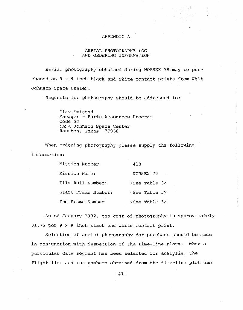
APPENDIX A
AERIAL PHOTOGRAPHY LOG AND ORDERING INFORMATION
Aerial photography obtained during NORSEX 79 may be pur~~
chased as 9 x 9 inch black and white contact prints from NASA
Johnson Space Center.
Requests for photography should be addressed to:
Olav Smistad Mana.ger - Earth Resources Program Code SJ NASA Johnson Space Center Houston, Texas 77058
When ordering photography please supply the following
information:
Mission Number 410
Mission Name: NORSEX 79
Film Roll Number: <See Table 3>
Start: Frame Number: <See Table 3>
End Frame Number <See Table 3>
As of January 1982, the cost of photography is approximately
$1.75 per 9 x 9 inch black and white contact print.
Selection of aerial photography for purchase should be made
in conjunction with inspection of the time-line plots. When a
particular data segment has been selected for analysis, the
flight line and run numbers obtained from the time-line plot can
-47-
be referenced to the photography log (Table 4) to identify the
first and last frame in that particular run and the film roll
number.
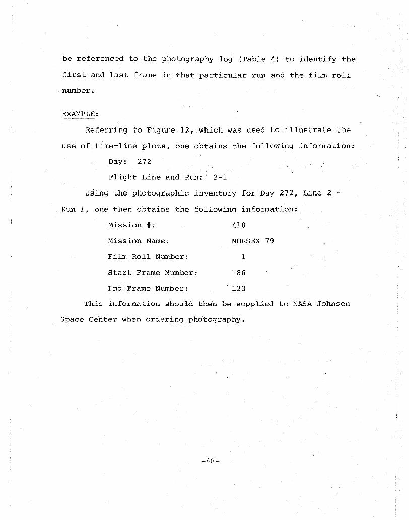
EXAMPLE:
Referring to Figure 12, which was used to illustrate the
use of time-line plots, one obtains the following information:
Day: 272
Flight Line and Run: 2-1
Using the photographic inventory for Day 272, Line 2 -
Run 1, one then obtains the following information:
Mission #: 410
Mission Name:
Film Roll Number:
Start Frame Number:
End Frame Number:
NORSEX 79
1
. 86
123
This information should then be supplied to NASA Johnson
Space Center when ordering photography.
-48-
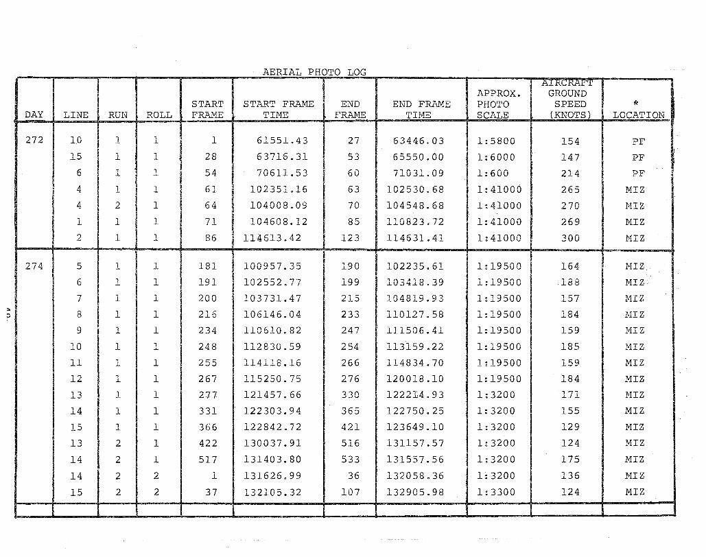
AERIAL PHOTO LOG Ai I-< 'I-( 1-"'1'
APPROX. GROUND START STA.,.~T FRAME END END FRAME PHOTO SPEED *
DAY LINE RUN ROLL FRAME TIHE FRAME TIHE SCALE (KNOTSL LOCATION
272 I,D 1 1 1 61551.43 27 63446.03 1:5800 154 PF
15 1 I 1
1 28 I 63716.31 I 53 65550.00 1:6000 147 PF
6 1 1 54 70611.53 60 71031.09 1:600 214 PF
4 1 1 I 61 102351.16 63 102530~68 1:41000 265 HIZ
4 2 1 64 104008.09 70 104548,,68 1:41000 270 HIZ !
1 1 1 71 104608.12 85 110823.72 1:41000 269 MIZ
2 1 1 86 114613.42 123 114631.41 1:41000 300 MIZ
274 5 1 1 181 100957.35 190 102235.61 1:19500 164 MIZ
6 1 1 1 a 1 102552.77
I 199 103418.39 1:19500 188 MIZ -'--"-'-
7 1 1 200 103731.47 215 104819.93 1:19500 157 HIZ :.. :> 8 1 1 216 106146.04 233 110127.58 1:19500 184 MIZ
9 1 1 234 110610.82 247 111506.41 1:19500 159 HIZ
10 1 1 248 112830.59 254 113159.22 1:19500 185 MIZ
11 1 1 255 114118.16 266 114834.70 1!lQ500 159 MIZ • I ~;~~5~~ I 12 1 1 267 115250.75 276 120018.10 184 MIZ
13 1 1 2J7 121457.66 330 122214.93 1:3200 171 MIZ
14 1 1 331 122303.94 365 122750.25 1:3200 155 MIZ
15 1 1 366 122842.72 421 123649.10 1:3200 129 MIZ ..L
13 2 1 422 130037.91 516 131157.57 1:3200 124 IvlIZ
14 2 1 517 131403.80 533 131557.56 1:3200 175 MIZ
14 2 2 1 131626 .. 99 36 132058.36 1:3200 136 MIZ
15 2 2 37 132105.32 107 132905.98 1:3300 124 MIZ

AIRCRAFT APPROX. GROUND
START START FRAME END END FRM1E PHOTO SPEED * DAY LINE RUN ROLL FRAIvlE TINE FRAME TIME SCALE (KNOTS) LOCATION"
277 3 1 2 122 93914.85 168 94433.96 1:3100 210 NIZ 20 1 2 179 120200.47 210 121623.96 1:4000 243 PF 21 1 2 211 122359.31 237 125129.65 1:4000 240 PF
281 4 1 2 251 55614:12 255 60033.08 1:4200 223 PF 1 4 2 256 61831:20 280 62234.03 1:4200 206 PF 2 1 2 281 63816.15 316 65920.47 1:4600 203 PF 3 1 2 317 71447.41 348 73934.93 1:4400 201 PF - - 2 349 83903.82 364 84444.24 1:4400 185 PF 5 1 2 365 84621.72 400 85755.46 1:4300 202 PF - - 2 401 92256.81 415 92822.44 1:4500 224 PF 1 1 2 458 133155.32 519 134155.06 1:3200 155 MIZ 1 1 3 1 134204.78 20 134606.77 1:3200 155 MIZ 2 1 3 21 134905.97 83 140413.38 1:3300 139 MIZ 3 1 3 84 142033.87 156 143241.29 1:3400 140 MIZ 4 1 3 157 143526.87 224 144620.05 1:3400 140 MIZ 5 1 3 227 150435.59 299 151810.97 1:3400 149 MIZ 5 2 3 300 152056.31 364 153535.64 1:3500 137 MIZ
283 1 1 3 379 114214.22 446 121711.68 1:3200 146 MIZ 2 1 3 447 122724.10 360 125450.84 1:6800 153 MIZ 2 1 4 4 125753.00 45 131048.18 1:6800 148 MIZ 3 1 4 46 132343.48 193 145354.68 1:3200 163 MIZ
AIRCRAFT APPROX: GROUND
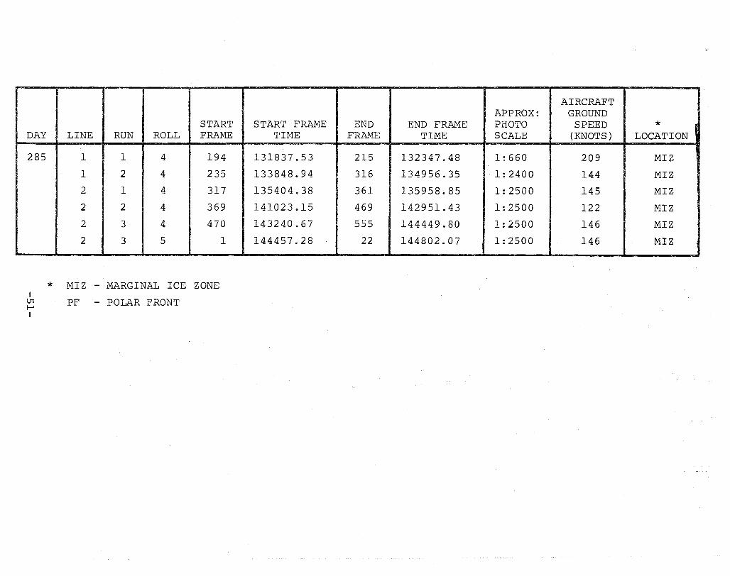
START START FRAME END END FRAME PHOTO SPEED * DAY LINE RUN ROLL FRAI!m TIME FRA..1V1E TIME SCALE (KNOTS) LOCATION
285 1 1 4 194 131837.53 215 132347.48 1:660 209 MIZ
1 2 4 235 133848.94 316 134956.35 1:2400 144 MIZ
2 1 4 317 135404.38 361 135958.85 1:2500 145 MIZ
2 2 4 369 141023.15 469 142951.43 1:2500 122 MIZ
2 3 4 470 143240.67 555 144449.80 1:2500 146 MIZ
2 3 5 1 144457.28 22 144802.07 1:2500 146 MIZ 1
* r.1IZ - MARGINAL ICE ZONE I ~ PF - POLAR FRONT I
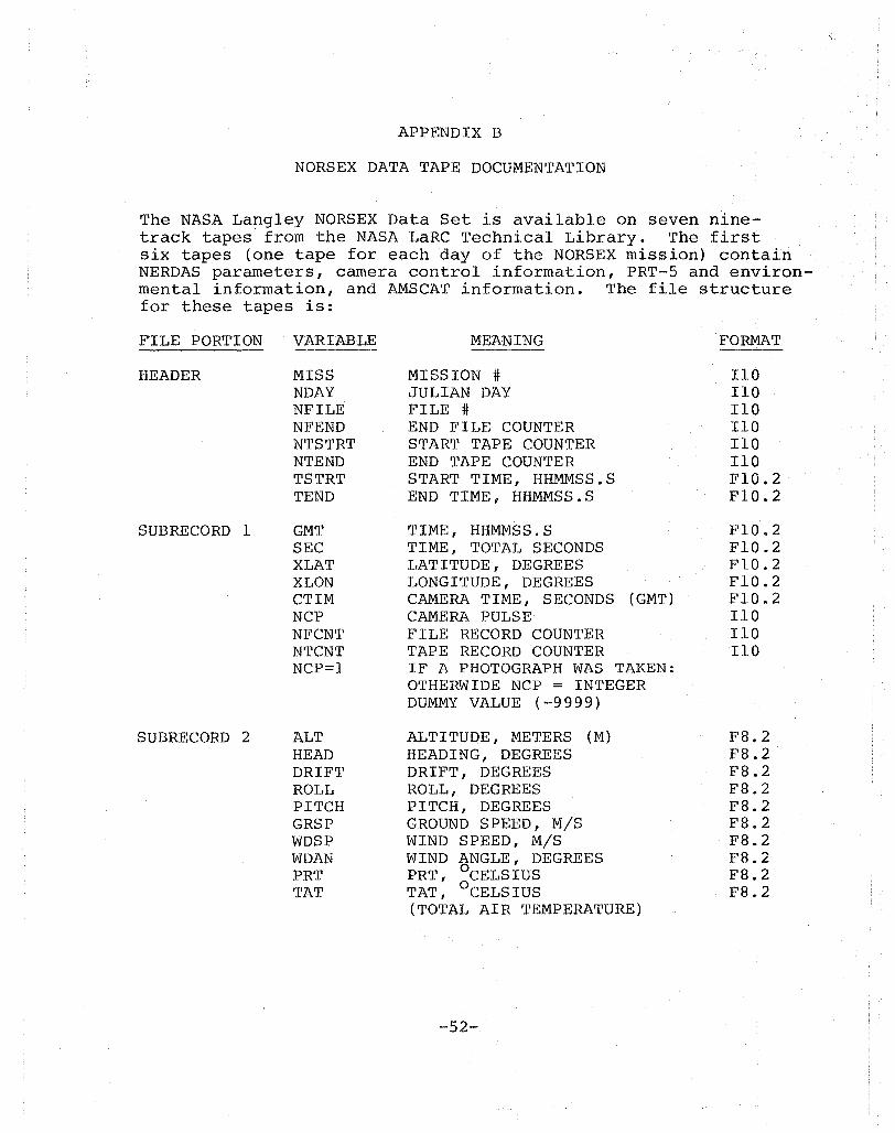
APPENDIX B
NORSEX DATA TAPE DOCUMENTATION
The NASA Langley NORSEX Data Set is available on seven ninetrack tapes from the NASA LaRC Technical Library. The first six tapes (one tape for each day of the NORSEX mission) contain NERDAS parameters, camera control information, PRT-5 and environmental information, and AMSCAT information. The file structure for these tapes is:
FILE PORTION . VARIABLE
HEADER MISS NDAY NFILE NFEND NTSTRT NTEND TSTRT TEND
SUBRECORD 1 GMT SEC XLAT XLON CTIM NCP NFCNT NTCNT NCP=l
SUBRECORD 2 ALT HEAD DRIFT ROLL PITCH GRSP WDSP WDAN PRT TAT
MEANING
MISSION # JULIAN DAY FILE # END FILE COUNTER START TAPE COUNTER END TAPE COUNTER START TIME, HHMMSS.S END TIME, HHMMSS.S
TIME, HHMMSS.S TIME, TOTAL SECONDS LATITUDE, DEGREES LONGITUDE, DEGREES CAMERA TIME, SECONDS (GMT) CAMERA PULSE FILE RECORD COUNTER TAPE RECORD COUNTER IF A PHOTOGRAPH WAS TAKEN: OTHERWIDE NCP = INTEGER DUMMY VALUE (-9999)
ALTITUDE, METERS (M) HEADING, DEGREES DRIF'l', DEGREES ROLL, DEGREES PITCH, DEGREES GROUND SPEED, MIS WIND SPEED, MIS WIND ANGLE, DEGREES PRT, °CELSIUS TAT, °CELSIUS (TOTAL AIR TEMPERATURE)
-52-
FORMAT
110 110 110 110 110 110 F10.2 F10.2
FlO.2 F10.2 FIO.2 F10.2 F10.2 110 110 110
FB.2 FB.2 FB.2 FB.2 FB.2 FB.2 FB.2 FB.2 FB.2 FB.2
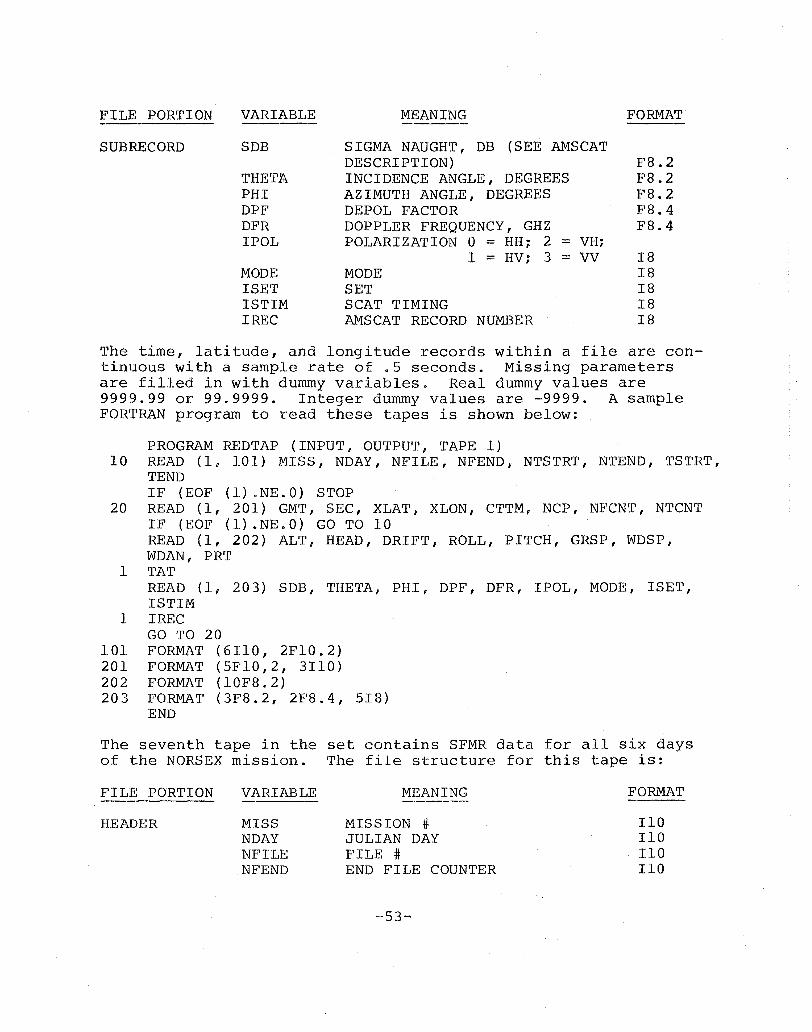
FILE PORTION VARIABLE MEANING FORMAT
SUBRECORD SOB SIGMA NAUGHT, DB (SEE AMSCAT DESCRIPTION) FS.2
THETA INCIDENCE ANGLE, DEGREES FS.2 PHI AZIMUTH ANGLE, DEGREES FS.2 DPF DE POL FACTOR FS.4 DFR DOPPLER FREQUENCY, GHZ FS.4 IPOL POLARIZATION 0 = HH;. 2 = VHi
1 = HV; 3 = VV IS MODE MODE IS ISET SET IS ISTIM SCAT TIMING IS IREC AMSCAT RECORD NUMBER IS
The time, latitude, and longitude records within a file are continuous with a sample rate of .S seconds. Missing parameters are filled in with dummy variables. Real dummy values are 9999.99 or 99.9999. Integer dummy values are -9999. A sample FORTRAN program to read these tapes is shown below:
PROGRAM REDTAP (INPUT, OUTPUT, TAPE 1) 10 READ (1, 101) MISS, NDAY, NFILE, NFEND, N'rSTRT, NTEND, TSTRT,
TEND IF (EOF (1) .NE.O) STOP
20 READ (1, 201) GMT, SEC, XLAT, XLON, CTTM, NCP, NFCNT, NTCNT IF (EOF (1) .NE.O) GO TO 10 READ (1, 202) ALT, HEAD, DRIFT, ROLL, PITCH, GRSP, WDSP, WDAN, PRT
1 TAT READ (1, 203) SDB, THETA, PHI, DPF, DFR, IPOL, MODE, ISET, ISTIM
1 IREC GO TO 20
101 FORMAT (6IIO, 2FIO.2) 201 FORMAT (SFIO,2, 3110) 202 FORMAT (10FS.2) 203 FORMA'll (3FS.2, 2FS.4, SIS)
END
The seventh tape in the set contains SFMR data for all six days of the NORSEX mission. The file structure for this tape is:
FILE PORTION
HEADER
VARIABLE
MISS NDAY NFILE NFEND
MEANING
MISSION #; JULIAN DAY FILE # END FILE COUNTER
-S3-
FORMAT
110 110 110 110
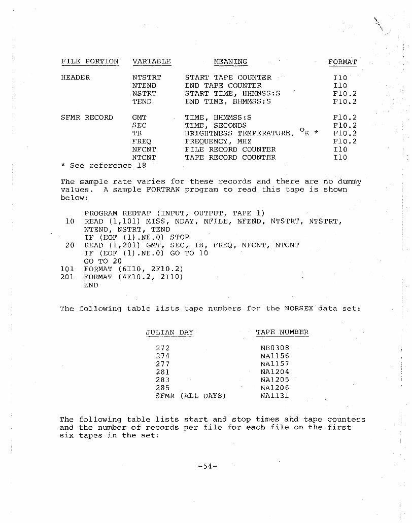
FILE PORTION VARIABLE MEANING FORMAT ---HEADER NTSTRT START TAPE COUNTER 110
NTEND END TAPE COUNTER 110 NSTRT START TIME, HHMMSS:S FIO.2 TEND END TIME, HHMMSS:S FIO.2
SFMR RECORD GMT TIME, HHMMSS:S FIO.2 SEC TIME, SECONDS FIO.2 TB BRIGHTNESS TEMPERATURE, OK * FIO.2 FREQ FREQUENCY, MHZ FIO.2 NFCNT FILE RECORD COUNTER 110 NTCNT TAPE RECORD COUNTER 110
* See reference 18
The sample rate varies for these records and there are no dummy values. A sample FORTRAN program to read this tape is shown below:
PROGRAM REDTAP (INPUT, OUTPUT, TAPE 1) 10 READ (1,101) MISS, NDAY, NFILE, NFEND, NTSTRT, NTSTRT,
NTEND, NSTRT, TEND IF (EOF (1) .NE.O) STOP
20 READ (1,201) GMT, SEC, IB, FREQ, NFCNT, NTCNT IF (EOF (1) .NE.O) GO TO 10 GO TO 20
101 FORMAT (6110, 2FIO.2) 201 FORMAT (4FIO.2, 2II0)
END
The following table lists tape numbers for the NORSEX data set:
JULIAN DAY 'l'APE NUMBER
272 NB0308 274 NAl156 277 NAl157 281 NA1204 283 NA1205 285 NAl206 SFMR (ALL DAYS) NAl131
The following table lists start and stop times and tape counters and the number of records per file for each file on the first six tapes in the set:
-54-

DAY 272 ':l'APE NUMBER NB0308
START s'rop END FILE START TAPE END TAPE FILE TIME . TIME . COUNrrER .. COUNTER COUNTER -- -----
1 55226.5 60233.0 1214 1 1214 2 60306.5 61345,.5 1279 1215 1493 3 615.32.0 65655.0 4967 2494 7460 4 65734.0 71224 .. 5 1782 7461 7242 5 71512.5 73131.0 1958 9243 11200 6 73210.0 74218.0 1217 11201 12417 7 100345.0 101701.5 1594 12918 14011 8 102257.0 110852 .. 0 5511 14012 19522 9 111241.5 114822.0 4282 19523 23804
10 120200.0 121935.0 2111 23805 25915 11 132316.0 140530.0 5069 25916 30984 12 140716.0 14573405 6038 30985 37022
nAY 274 TAPE NUMBER: NA1156
S':rART STOP END FILE STAR~r TAPE END TAPE FILE TIME TIME COUNTER COUNTER COUNTER
1 54546.5 54850.0 368 1 368 2 55031.0 62336.5 3972 369 4340 3 63147.5 71825.0 5596 4341 9936 4 71931.5 72823.0 1064 9937 11000 5 72918.5 74226.0 1576 11001 12576 6 90837.5 93642.0 3370 12~/l 15946 7 93730.5 93955.0 290 15947 16236 8 94049.0 94606.0 635 16237 16871 9 94705.5 95840.5 1391 16872 18262
10 100801.5 110130.5 6491 18263 24681 11 110200 .. 5 111846.0 2012 24862 26693 12 111921.5 120111.0 5020 26694 31713 13 120213.5 124054.5 4643 31713 36356 14 124132.0 125748.5 1954 36357 38310 15 125828.5 133500.5 4385 38311 42695 16 133812$5 141140.0 4016 42696 46711 17 141415.0 142829.0 1710 46712 48421 18 145945 .. 0 151348.0 1637 48422 50108 19 151526.0 160642.5 6154 50109 56262
-55-
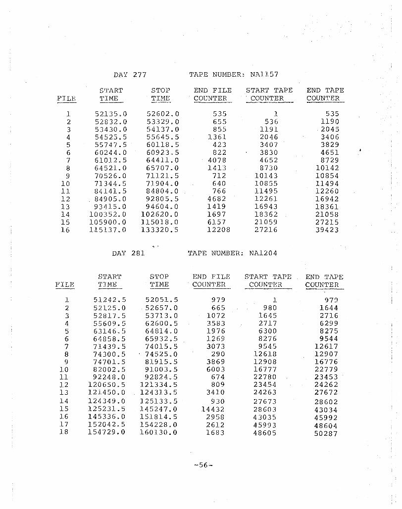
DAY 277 TAPE NUMBER: NAl157
START STOP END FILE START TAPE END TAPE FILE TIME . TIME . COUNTER .. COUNTER . COUNTER
1 52135.0 52602.0 535 1 535 2 52832.0 53329.0 655 536 1190 3 53430.0 54137.0 855 1191 2045 4 54525.5 55645.5 1361 2046 3406 5 55747.5 60118.5 423 3407 3829 6 60244.0 60923.5 822 3830 4651 7 61012.5 64411.0 4078 4652 8729 8 64521.0 65707.0 1413 8730 10142 9 70526.0 71121.5 712 10143 10854
10 71344.5 71904 .. 0 640 10855 11494 11 84141.5 84804.0 766 11495 12260 12 84905.0 92805.5 4682 12261 16942 13 93415.0 94604.0 1419 16943 18361 14 100352.0 102620.0 1697 18362 21058 15 105900.0 115018.0 6157 21059 27215 16 115137.0 133320.5 12208 27216 39423
DAY 281 TAPE NUMBER: NA1204
START STOP END FILE START TAPE END TAPE FILE TIME . TIME ' COUNTER COUNTER COUNTER ---
I 51242.5 52051.5 979 1 97fJ 2 52125.0 52657.0 665 980 1644 3 52817.5 53713.0 1072 1645 2716 4 55609.5 62600.5 3583 2717 6299 5 63146.5 64814.0 1976 6300 8275 6 64858.5 65932,,5 1269 8276 9544 7 71439.5 74015.5 3073 9545 12617 8 74300.5 74525.0 290 12618 12907 9 74701&5 81915.5 3869 12908 16776
10 82002.5 91003.5 6003 16777 22779 11 92248.0 92824.5 674 22780 23453 12 120650.5 121334.5 809 23454 24262 13 121450.0 124313.5 3410 24263 27672 14 124349.0 125133.5 930 27673 28602 15 125231.5 145247.0 14432 28603 43034 16 145336.0 151814.5 2958 43035 45992 17 152042.5 154228.0 2612 45993 48604 18 154729.0 160130.0 1683 48605 50287
--56-
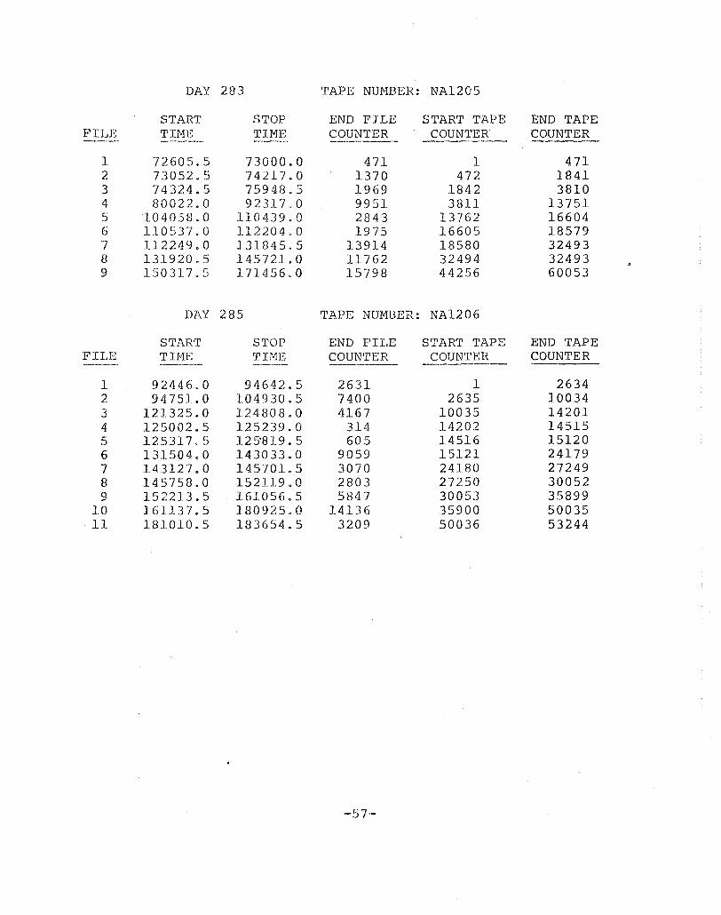
DAY 283 'rAPE NUMBER: NA120S
START STOP END FILE START TAPE END TAPE FILE TIME TIME COUNTER .. COUN'I'ER . COUNTER --- ----
I 72605.5 73000.0 471 1 471 2 73052.~) 74217.0 1370 472 1841 3 74324.5 75948.5 1969 1842 3810 4 80022.0 92317.0 9951 3811 13751 r:' .) 104058.0 110439.0 2843 13762 16604 6 110537.0 112204.0 1975 16605 18579 7 112249.0 131845.5 13914 18580 32493 8 131920.5 145721.0 11762 32494 32493 9 150317.5 171456.0 15798 44256 60053
DAY 285 TAPE NUMBER: NA1206
S'rART STOP END FILE START TAPE END TAPE FILE TIME TIME COUNTER COUNTER COUNTER --- -----
1 92446.0 94642.5 2631 1 2634 2 94751 .. 0 104930.5 7400 2635 10034 3 121325.0 124808.0 4167 10035 14201 4 125002 .. 5 125239.0 314 14202 14515 5 125317.5 125'819.5 605 14516 15120 6 131504.0 143033.0 9059 15121 24179 7 143127.0 145701.5 3070 24180 27249 8 145758.0 152119.0 2803 27250 30052 9 152213.5 161056.5 5847 30053 35899
10 161137.5 180925.0 14136 35900 50035 11 181010.5 183654.5 3209 50036 53244
--57--
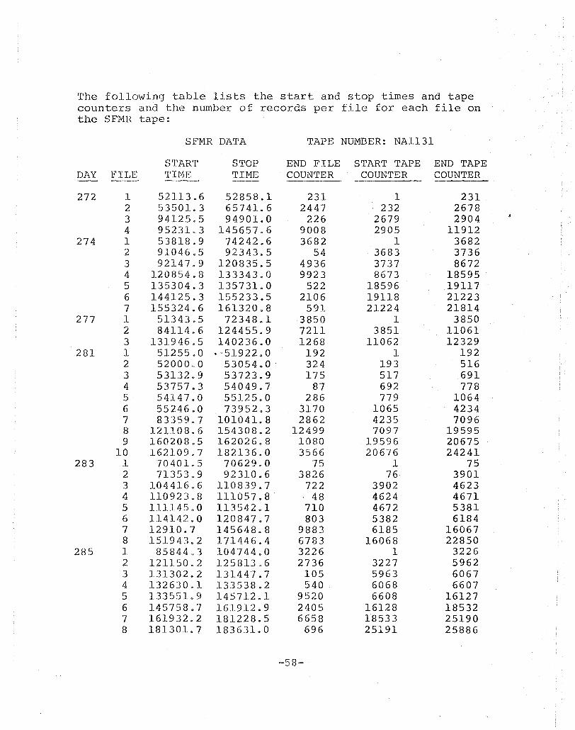
The following table lists the start and stop times and tape counters and the number of records per file for each file on the SFMR tape:
SFMR DATA TAPE NUMBER: NA1131
START STOP END FILE START TAPE END TAPE DAY FILE TIME TIME . COUNTER COUNTER COUNTER -272 1 52113.6 52858.1 231 1 231
2 53501.3 65741.6 2447 232 2678 3 94125.5 94901.0 226 2679 2904 4 95231.3 145657.6 9008 2905 11912
274 1 53818.9 74242.6 3682 1 3682 2 91046.5 92343.5 54 3683 3736 3 92147.9 120835.5 4936 3737 8672 4 120854.8 133343.0 9923 8673 18595 5 135304.3 135731.0 522 18596 19117 6 144125.3 155233.5 2106 19118 21223 7 155324.6 161320.8 591 21224 21814
277 1 51343.5 72348.1 3850 1 3850 2 84114.6 124455.9 7211 3851 11061 3 131946.5 140236.0 1268 11062 12329
281 1 5125580 • -51922.0 192 1 192 2 52000.0 53054.0 324 193 516 3 53132.9 53723.9 175 517 691 4 53757.3 54049.7 87 692 778 5 54147.0 55125.0 286 779 1064 6 55246.0 73952.3 3170 1065 4234 7 83359.7 101041.8 2862 4235 7096 8 121108.6 154308.2 12499 7097 19595 9 160208.5 162026.8 1080 19596 20675
10 162109.7 182136.0 3566 20676 24241 283 1 70401 .. 5 70629.0 75 1 75
2 71353.9 92310.6 3826 76 3901 3 104416.6 110839.7 722 3902 4623 4 110923.8 111057.8 . 48 4624 4671 5 111145.0 113542.1 710 4672 5381 6 114142.0 120847.7 803 5382 6184 7 12910.7 145648 .. 8 9883 6185 16067 8 151943.2 171446.4 6783 16068 22850
285 1 85844.3 104744.0 3226 1 3226 2 121150.2 125813.6 2736 3227 5962 3 131302.2 131447.7 105 5963 6067 4 132630.1 133538.2 540 6068 6607 5 133551 9 145712.1 9520 6608 16127 6 145758.7 161912.9 2405 16128 18532 7 161932.2 181228.5 6658 18533 25190 8 181301.7 183631.0 696 25191 25886
-58-
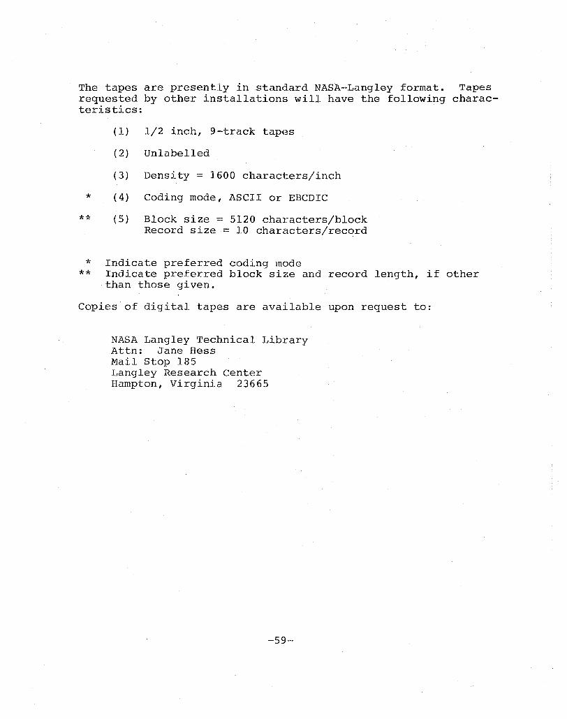
The tapes are presently in standard NASA-Lan91ey format. Tapes requested by other installations will have the following charac-teristics: .
*
**
* **
(1) 1/2 inch, 9-track tapes
(2) Unlabelled
(3) Density = 1600 characters/inch
(4) Coding mode, ASCII or EBCDIC
(5) Block size = 5120 characters/block Record size = 10 characters/record
Indicate preferred coding mode Indicate preferred block size and record length, if other than those given.
Copies of digital tapes are available upon request to:
NASA Langley Technical Library Attn: Jane Hess Mail St.op 185 Langley Research Center Hampton, Virginia 23665
-59--

APPENDIX C
NORSEX TIME-LINE PLOTS AND FLIGHT LINES
-60-

DAY 272
-61-
\
I \
\ \ \
\
\ \ , \
\
\ \ ./ \ \ \ \ 'v '\
\ \\\ \\). \ '\
\ \ \ \ \ ,> '\ '\ '\ \ \< \ \ '\ \ \." \ \ \\\,\, \ \"
.... \ \ \ ",\ \ ..... \ \ '\ \ '\
\ \ \ \ \ \ \' \ \ \ \
\ \ ).. \' \\ \ \ A
\\\\ \' ,"'\ \
\ \ \ \;' /, \ \ \ ..... \ .... \ \ \
.k~' \' \ \ .><- -, \
\ \ \ \ \ \ , 80 \ ,
\ \
\ \
, \
\
78 , -t' -
\
\ \
\
\
\
- \.- \-
\ \ \
\ \ \
\ \ :>-\ v
\.... , \, ,
\ ' \ \ \
\ \ , \ \
FLIGHT' \ LINE ..... ).
\ \ \ \
\ ...... \ \ \ .... \
,... ( , \
76 \ \ \ \ \ - .....
_\ _ L -1 .- \" \ \
74 I-
, \ \
\ , \ \ \ \
\ NORWEGIAN SEA \ , \ \
, \
T - L-
\
-,
\ , \ , \
\
\
\
\
\
\ .-
\
\
.- \ -\
\
\
\
\ \
\
\
\
\
.1 ,1..--
\ \ \
\\ \ \ \ \
\ \
, \
\
\ .,.. .,.. \
\
\
\ \ \ \ \
\ ~ , ;\ -\-
..... , ..... \
\ , 72N t -\-1-:- - ,-
- \ \ \ \,' 12 \
'4 \6 '8 \ 10 \12 '14 '16E'
-62-
\
\
4
I 84
, I
I
I
\
\
8
\
\
&13'\
1 \ , \
I I
82 T - r
I ,
\
\
\
\
81 -'- -'- -,
\ , SO - -t - -\-
I \
2 4 6
\
\
,b '}.O. '}.~." COA \ \ \ \ \ ,,-" \
\ \ ./ \ \
./\ \
NORSEX \ C-130 FLIGHT PATH \
SEPTEMBER 29") 1979 \ \
\
8
\
\
\
\ \ \ \ CO~·
\ \ \ \--- ..... .",.. \
\ \./\'" \
"\ - \ \ \
\
L -
\ ,\ \
\
\
\
\
\
\
\
\
\
-\r-- - \
\
\
\
\
\
\
\
-~ - \ \
\
\ \ \
\
\ \ \
\
\
\
\
\
\
\
\
\_S' \
\
\ \
\ \ \- SO
j - -\-:j\ \ \ \
\ \bOf~ ~"o \ 12 ,4
-63-
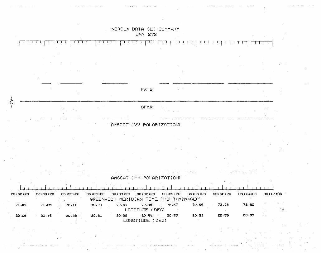
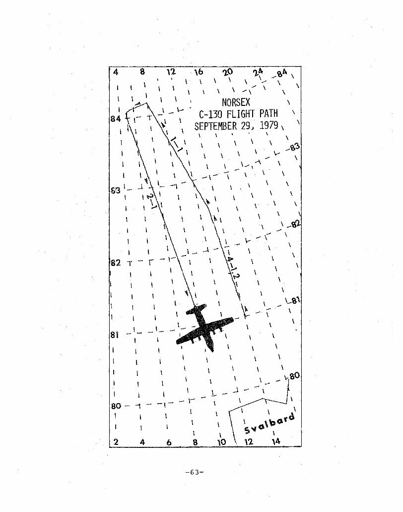
NORSEX DATA SET SUMMARY DAY 272
f11-r ·· [ Ij.! r-T··' r l' I , I I I I [ I I I I r I I I i·1 ( IT-r
I 0"1 ~
I
05:52:26
71.61.1
20.08
05:5,*126 05:86:26
71.38 72.11
2D.1S 2D.23
PRTS
SFMR
AMSCAT (VV POLARIZATION1
AMSCAT (HH POLARIZATION)
05,58:26 06:00:26 06:02:26 06:0l!:26 06:06:26
GREENWICH MERIDIAN TIME ( HOUR :MfN :SEC) 72.2'* 72.37 72.11.6 72.57 72.65
LATITUDE ( DEG) 20.3L 20.36 2D .11.,* 20.50 20.53
LONG ITUDE (DEG)
06:08:26 06 s 10 :26 06112:26
72.73 72.80
20.56 20.63

NORSEX DATA SET SUMMARY DAY 272
f T -11- I '1-1 ! I r '-I I I I I I I I I I i 'I I I I I fl I I I-I rl' I Ir '-IT-' fr--r 1 I r I I 'I I I I I ~
I 0"'1 U1 I
OB,.12.128
72..88
20.88
OB,.11i,2B
0000 0000000000000 0 0 000 0 0
PHOTOGRAPHY
10-1
FLIGHT LINES
PRT5
SFMR
AMSCAT (VV POLARIZATION)
06f 1B 128 OB.18128 OBs2O =28' 06 :22:28 06s2Q,.28 0622B:28 OB:2S:2B 06130s28 06.32128
GREENWICH MERIOfAN TIME (HOUR:MIN:SEC) 73.01i 73.11 73.18 73.25 73.32 73.38 73.t,ta 73.53
LATI TUDE (DEG) 20.a7 20.52 20.35 20.21 20.06' 1S.S0 13 ... 711 1S.58
LONG I TUDE (DEG)
I 0'\ 0'\ I
10-1
06:32:26
73.60
13.QS
NORSEX DATA SET SUMMARY DAY 272
I I I ~'l I I I I '-I I I I I I I I I I I~r-T-IT I I I I I I I I I I I o 0 C 00 0 000 0 0 00 000000
PHOTOGRAPHY
15-1
FLIGHT LINES
PRT5
SFMR
AMSCAT (VV POLARIZATION)
06:3q:26 06:36:26 06:38:26 06:qO:2B 06sQ2:26 06:QQs2B 06sQ6:26 06:QS:26
GREENWICH MERIDIAN TIME (HOUR:M N:SEC) 73.67 73.73 73.81 73.83 73.37 7Q.05 7Q.13 7Q.21
LAl'I TUDE (DEGl 13.87 13.11 13.01 13.01 13.01 13.01 13.00 13.00
LONG I TUDE (DEG)
06:50:26 06,52:26
7Q.23
13.00
I
'" ...J I
NORSEX DRTR SET SUMMARY DAY 272
~ I I I I I I I I I I TIT! Ii' I I I I ,. I I I I I I I 1···I-i'TT'--1 I I I I I I I Til I I I I
000 00 0 0 <II> 000 0 0 0 0
PHOTOGRAPHY
15-1
FLIGHT LINES
PRT5
SFMR
AMSCAT (VV POLARrZATION)
RMSCRT (VH POLARIZATION)
AMSCRT (HV POLARIZATION)
AMSCAT CHH POLARIZATION)
08.51128 08:53r28 08:55,-26 08.57,26 06.59.26 07.01.26 07'03:26 07:05:26 07:07.26 07:09.28 07111 s26
GREENWICH MERIDIAN TIME (HOUR~MIN:SEC) 7'*.33 7'*.'*1 7,*,,*9 7,* .61! 7,*.72 7'* .. 83 7'*.35 75.07 75.13
LAT I TUDE (DEG) 19.00 19.00 19.00 18 ... 88 18.83 18.78 18.67 18.58 18.,*S
LONG I TUDE (DEG)

I
'" ex> I
NORSEX DATA SET SUMMARY DAY 272
rTIII---rr-T T II 'il I 1 I I 1 I I I I r-I I I I ,-TT-I-'-- I
PRT5
AMSCAT (VV POLARIZATION)
AMSCAT (VH POLARIZATION)
AMSCAT (HV POLARIZATION)
AMSCA- (HH POLARIZATIO~)
07s11s26 07 r 13 .26 07.15.26 07 s 17 '26 07119.26 07121.26 07s23126 07.25.26
GREENWICH MERIDIAN TIME (HOUR:MIN:SEC) 75.31 75.53 75.51:l 75.75 7S.66 76.00 76.13
LAT I TUDE (DEG) 16.39 18.21 18.11 16.01 17.'30 17.80 17.68
LONG I TUDE (DEG)
07'27'26 07.29.26 07.31.26
76.27 76.l:ll
17.57 17.1:l3
I ~ \.0 I
NORSEX DATA SET SUMMARY DAY 272
I fr I rl I T-l1 'Tll ~r'Tr-1 l---rTj T-rl
PRT5
SFMR
AMSCAT (VV POLARIZATION)
AMSCAT (VH POLARIZATION)
AMSCAT (HV POLARIZATION)
AMSCAT (HH POLARIZATION)
10s03sY,5 10s05sY,5 10s07sY,5 10s09fY,5 10.11 fY,5 10: 13 ,Y,5 10 s 15 :Y,S
GREENWICH MERIDIAN TIME (HOUR:MIN:SEC) 79.51:1: 79.65 79.81:1: 75.55 80.11:1: 80.25 80.1i1:l:
LAT I TUDE (DEG) 11i.36 11:1:.35 lli.32 11i.31 11i.27 IIi.2Y, 11:1:.22
LONG I TUDE (DEG)
10 J 17,1:1:5 10: 191Y,5 1012111:1:5
I ....,J o I
10120:Y:5
Y:-1
10.22.Y:5
NORSEX DATA SET SUMMARY DAY 272
I I I I I I '1 Til I '1-.--r IIIJ' II rTJ ITI
000
PHOTOGRAPHY
Y:-2
FLIGHT LINES
PRT5
SFMR
AMSCAT (VV POLARIZATION)
AMSCAT (VH POLARIZATION)
AMSCAT (HV POLARIZATION)
AMSCAT (HH POLARIZATION)
10s2y:.Y:5 10:26'Y:5 10,281Y:5 10.30:Y:5 10:32:'!5
GREENWICH MERIDIAN TIME (HOUR:MIN:SEC) 81.10 81.25 81.Y:0 81.5'! 81.63
LAT I TUDE (DEG) lY:.03 13.36 13.B6 13.76 13.66
LONG I TUDE (DEG)
10:3'!sY:5 10:36sY:5 IDsSSsY:5
81.8Y: 81.33 B2.1Y:
13.56 13.Y:7 13.37
I -..J I--'
I
q-2
10s38.liS
82.1Q
13.37
NORSEX DATA SET SUMMARY DAY 272
! ! I I I I 'IT II-T-'ll I I I 1-1-11 1 I fl I i I I 'TI-1 Tj I I. I I I I TI I I r I o 00 0 0 000 0 00 CD) 0 0 0 0 0 0 0
PHOTOGRAPHY
1-1
FLIGHT LINES
PRTS
SFMR
AMSCAT (VV POLARIZATION)
AMSCAT (VH POLARIZATION)
AMSCAT (HV POLARIZATION)
AMSCRT (HH POLARIZRTION)
10.liOsliS 10sq2sqS 10.qq.liS 10sliS.liS 10sli6.QS 10sS0sliS 10s52sliS 10sSQ.QS 10.56.QS 10.58st.!S
GREENWICH MERIDIAN TIME (HOUR:MIN:SEC) 82.23 82.Q3 82.56 62.72 82.67 63.01 83.15 83.23 83.Q3 83.57
LAT I TUDE (DEG) 13.25 13.12 13.00 12.SQ 12.29 11.31 11.5Q 11.11 10.66 10.22
LONG I TUDE (DEG)

I -.J tv I
NORSEX DATA SET SUMMARY DAY 272
r r I II T 11 I I I I-I I I I I 'I I I I I 1- I I r IT'T" I I I I I
o 0 0
PHOTOGRAPHY
1-1 2-1
FLIGHT LINES
PRT5
SFMR
AM SCAT (VV POLARIZATION)
AMSCAT (VH POLARIZATION)
AMSCAT (HV POLARIZATION)
AMSCAT (HH POLARIZATION)
10158.1.:1:6 11 sOOsl.:l:6 11 s02 ,I.:I:S 11:0Q ,I.:I:S 11 s06sl.:l:S 11 s08sl.:l:6 11 s10sl.:l:6 11s12sl.:l:6 11:11.:1:,1.:1:6
GREENWICH MERIDIAN TIME (HOUR:MIN:SECl 63.57 63.70 63.61.:1: 63.36 8ll.11 81.:1:.23 61.:1:.11 83.56
LAT I TUDE (DEG) 10.22 2.76 2.2S 8.80 8.2Y: 7.51 Y:.72 5.13
LONG I TUDE (DEG)
11.1611.:1:6
63.75
5.57
i -....l W I
NORSEX DRTR SET SUMMRRY DAY 272
r T, f'TTT-I ·l· r-TT I I I 11 I I f I 1 I I I I T '1 r-T-T r . I I I I I I I I I I I I I I I I o 00 0 0 0 0 0 0 0 0 0 0 00 0 0 0 0 0 0 0 0
PHOTOGRAPHY
2-1
FLIGHT LINES
PRT5
SFMR
AMSCAT (VV POLRRIZATION)
RMSCAT (VH POLARIZATION)
AMSCAT (HV POLARIZATION)
AMSCAT (HH POLARIZATION)
11:18,Li7 l1s18sLi7 11s20sLi7 11=22,Li7 11s2LisLi7 11s2BfLi7 11 s28 sLi7 11s30r'i7 11s32sLi7 11'31!~1!7
GREENWICH MERIDIAN TIME (HOUR:MIN:SECl 83.73 83.83 83.Li7 83.31 53.II! 82.38 82.82 82.66 82.1!3 82.33
LAT I TUDE (DEG) 5.57 5.31 6.28 6.62 6.35 7.26 7.55 7.83 8.10 8.35
LONG I TUDE (DEG)
I ....,J ~
I
NORSEX DATA SET SUMMARY DAY 272
jT-TII-TT' -, II r I I I I .! I} I· I I I !J- T I I I I I I I I I I 0000000000 00
PHOTOGRAPHY
2-1
FLIGHT LINES
PRT5
SFMR
RMSCAT (VV POLARIZATION)
RMSCAT (VH POLARIZATION)
RMSCAT (HV POLARIZATION)
AMSCAT (HH POLARIZATION)
11sSQ,q7 11:S6:q7 11s38sQ7 11sQOsQ7 11:q2rQ7 11:Qq:q7 11SQ6:q7 11sQSsQ7 11150sQ7 11s52:Q7
GREENWICH MERIDIAN TIME (HOUR:MIN:SEC) 82.33 82.17 82.01 81.85 81.70 81.53 81.38
LATITUDE (DEG) 8.S5 8.53 8.8S 3 .. 0Q 9.2Q 9.QS 9.65
LONG r TUDE (DEG) /
/:f
I -...J U1 I
NORSEX DATA SET SUMMARY DRY 272
r rr[TI1IT I I '-1 I I I r-l I I I I I I I I I I I I I I I I fl lr, I illTT-TTT1T-TTil
SFMR
12,02rOO 12:0li'OO 12106:00 12.08,00 12:10.00 12s12.00 12.1l:ls00 12116.00 12.18.00 12:20'00
GREENWICH MERIDIAN TIME (HOUR:MIN:SECl 81 .. l:lli 81.53 81.62 81.71 81.80 81 .. 63 81.33 82.08 82.17
LAT I TUDE (DEG) 3.60 3.li3 9.39 3.26 9.17 9.06 8.95 8.81 8 .. 62
LONG I TUDE (DEG)
I -...J 0"1 I
r II-,-r -'T 1- 1-' -, ITI I TTl
13.23116 13s25s16 13'27:16 13.23s16
NORSEX DATA SET SUMMARY DAY 272
PRT5
SFMR
RMSCAT (VV POLARIZATION)
AMSCAT (HH POLARIZATION)
13.31:16 13133.16 13s35:16 13=37.16
GREENWICH MERIDIAN TIME (HOUR=MIN=SEC) 77.32 77.77 77.62 77.li6 77.30 77.1li 76.33 76.S3
LATITUDE (DEG) 11i.SS 15.00 15.12 15.26 15.37 15.liS 15.60 15.72
LONG I TUDE (DEG)
! I
13.33.16 1311.11116 lSsli3.16
76.67 76.51 76.35
15.S3 15.51.1 16.0li
I -...J -...J I
13 stiS s 18
78.35
16.01:l
lS sl:l5 s18
76.20
16.11.1
NORSEX DATA SET SUMMARY DAY 272
'1'- f,---I'l 1--' II r- r 1 - 1 T1 r, I TI I-r 1 T -, IHI '1'- rll--'l
PRT5
SFMR
RMSCRT (VV POLARIZATION)
AMSCAT (HH POLARIZATION)
1Ss1:l7:18 13 :I:lSsI8 13:51f18 13 :53 f 18 13:55f18 13:57:18 1315S:18 11:ls01118
GREENWICH MERIDIAN TIME (HOUR:MIN:SEC) 76.01:l 75.8S 75.73 75.57 75.l:ll 75.25 75.09
LAT I TUDE (DEG) 18.21.1 16.31.1 16.1:l3 16.53 16.62 16.71 16.80
LONG I TUDE (DEG)
I .....:J (X)
I
NORSEX DATA SET SUMMARY DAY 272
I I I I I I I I I· r-,'T rT~-1 T----.11-1 I I III I T~ IT, r-TT
PRT5
SFMR
AMSCAT (VV POLARIZATION)
AMSCAT (HH POLARIZATION)
1I:l sOl :16 11i s03: 16 11i :05 s16 l1i:07:16 I tU09s16 lY:sll:16 iii s13 :16
GREENWICH MERIDIAN TIME (HOUR:MIN:SEC) 7li.Sli 7Y:.78 71i .. 62 71i.1i7 7Y:.31 7Y:.16 7li.OO
LAT I TUDE (DEGl l6.BB 18.97 17.05 17.13 17.21 17.29 17.36
LONG I TUDE ( DEG)
1lisi5s16 lli:17t16 11.!t19s16
73.8q 73.88
17.Y:3 17.50

-.....l \.0 I
NORSEX DATA SET SUMMARY DAY 272
rTn~TTTrT-r-T'T IJ -r r ',--I -r r rTllr-ll'T~IT-i I-II '-;-1 I I 1'1
PRT6
SFMR
AMSCAT (VV POLARIZATION)
111:13116 111:21:16 l iH23s16 III :25: 16 III 127 :16 111 =23 :16 111:31:16 111 :33 It 16 llis35:16 111137:16 1l:lISSs16
GREENWICH MERIDIAN TIME (HOUR:MIN:SEC) 73.53 73.37 73.21 73.06 72.30 72.711 72.55 72.113 72.27 72.12
LAT I TUDE (DEG) 17.58 17.65 17.73 17.73 17.85 17.52 17.58 lS.01l 18.11 18.16
LONG I TUDE (DEG)

I 00 o I
NORSEX DATA SET SUMMARY DAY 272
I 1 I I I fl I I I I I 1 I 1 r-l It I I I I 11 I I I I 1-1 ,- I 1-1 Ii 1111 rl 1- T II '1- r
PRT5
SFMR
RMSCAT (VV POLARIZATION)
l 1U39,16 11i ,IU .16 l'U1.13 ,16 lli .1.15 s 16 llisli7s16 llil1i9:16 11.1161.16 11i,53s16 11.1s55.16
GREENWICH MERIDIRN TIME (HOUR:MIN:SEC) 71.96 71.82 71.66 71.50 71.32 71.15 70.98 70.81 70.63
LRT I TUDE (DEG) 18.23 18.26 18.31i 18.39 18.56 18.51 IB.59 IB .. 62 U'.66
LONG I TUDE (DEGl
lll.57s16 lll.59s16
70.1.16
18.7ll

DAY 274
~81-
\
\ \ \ \ Y
\ \ \ \ \ .... \ \ \./ \
\ \ \ \ \
./ \ \ \ \ ./\ \ , , \ ).. ./ \ \ \ \
\ \ \ \ \ \
\ \ \ \
\ \ \
\ \ \
\ \ \ \
\ \ ./
\ \ \ ...... \
\ \./ ~ \
\ \ , \
\ \ 1 \
\ \ , .
\ \ \
\
78 \ \ \ \ \ - \ \
-+ - - r \ \ \ \
\ \ \ \ \ ,
\ \ \ \ \ .....
\ \ ./
Y . I \ \ ..... \
\ ~ \
\ , ...... ...... \ \ \ \ \
\
\ ...... \- \ ,
76 \ .J - ¥ \ ~FLIGHT \ 1 - - \ \ -, - \ \ \ \ LINE \ \ \ \ \
\ \ \ \ \
NORWEGIAN SEA \ \ ......
\ ..... "\ \ \
\ ..... ~ \ \ \ \
J ..... \ \ I -\-, -\- \ \
741 \ _\- \ \.- - - \ \
I \ \ \ \ \ \ ,
\ \ \ \ \ \
t \ \ \ \ \ \ , \ \ \
..... \ \ ..... \
\ \ \ \ , _\ -t \ \ - ~ \ \
72NI L t' - '1 \ - \- - \
\ \ \
I \ \ \ \ \ ~ ,4 '6 \8 dO \ 12 d4 \ 16E \
-82-
0- - -......
-- - -- -
- - -
o o ..
- - -
::x:::: ~R 0- en I-r-I
>< ::t: LJ.j,<..Dr--i (/) -.. ""---''''' - - - - - - - --o U- I., Z 1-1-.1
0t:Cl IV'\0 r-II-
.(....)
w O
_ML--==--'::-::"-:-- - - - - - -
-83-
o o -----_ ... ---
o ----- ......
_---- 00
I CO ,j:::.
I
NORSEX DATA SET SUMMARY DAY 27L:l
rT!~TI TT I I '~l 1 11
PRTS
SFMR
AMSCAT (VV POLARIZATION)
AMSCAT CHH POLARIZATION)
06.lt6.lt6 06.lt7.ltS 06.liS.I.1S 06.51 sitS OS.SS.lt6 06,66'1.16 06167slt6 06.6S.ltS
GREENWICH MERIDIAN TIME (HOUR:MIN:SEC) 70.51.1 70.66 70.S0 71.03 71.16 71.23 71.liS
LRT I TUDE (DEG) 18.89 18.87 18.78 18.71t 18.70 18.66 18.60
LONG I TUDE (DEG)
06.01.lt6 OSIOSsliS 06.06.l,l6
71.56 71.68 71.81
18.66 18.61 18.li7
I 00 U1 I
~
NORSEX DATA SET SUMMRRY DAY 274:
I I I II I II I I' fl I II III -11 rl'TT TIl T1'--11 T--'111 TTi--r 11T- 1
PRT5
SFMR
AMSCAT (VV POLARIZATION)
AMSCAT (HH POLRRIZATION)
OS.S1.1i? OSISS.Ii? OSsSS.Ii? OSsS7.t!7 OS'3S.1i7 OS.lil'li7 OS.1i311i7 OSlliSlli7 OSrIi7'!..!:7 GREENWICH MERIDIAN TIME (HOUR:MIN:SEC)
7S.50 73.56 7S.SIi 7S.li7 7S.li2 7S.62 7S.SS 7S.78 7S.S1 LAT I TUDE (DEG)
17.S9 17.7L! 17.90 17.99 1?99 17.99 17.99 17.98 17.98 LONG I TUDE (DEG)
OS'Ii~Hli7 OS.Sllli?
7L!.OIi 71i .18
17.99 17.99
I co U"I I
08.05.li7
71.82
18.1.l8
08'07.1.l7 06.09.1.l7
71.SI.l 72.07
18.1.l2 18.37
NORSEX DATA SET SUMMARY DAY 274:
If-'l--l~r--ll TT lr-Tl-lilli-TT I !---.--tl Tr-T-TT'l
PRT5
SFMR
AMSCAT (VV POLARIZATION)
AMSCAT (HH POLARIZATION)
0811111.l7 08.13.li7 06.15.1.l7 06117 'li7 0611S'li7 06'21.li7 06.2$.1.l7 06.25.1.l7
GREENWICH MERIDIAN TIME (HOUR:MIN:SEC) 72.20 72.33 72.1.l6 72.59 72.72 72.85
LAT I TUDE (DEG) 18.33 18.27 18.21 18.16 18.12 18.06
LONG I TUDE (DEG)
NORSEX DATA SET SUMMARY DAY 271.J:
I 1 r I I -llT I 1 I f T-l II 1'1 TI TTl-TIT
I co 0'\ I
07.11 .llS
7S.53
17.33
07 113 IllS
75.S6
17.33
PRT5
SFMR
AMSCAT (VV POLARIZATION)
AMSCAT (HH POLARIZATION)
07.15 'llS 0711 7.ll8 0711S.tI8 07'21.ll8 07.23.I,lS
GREENWICH MERIDIAN TIME (HOUR:MIN:SEC) 75.S0 75.S3 76.07 76.03 76.05
LATITUDE (DEG) 18.00 17.S3 17.3S 17.SI,l 17.73
LONG I TUDE (DEG)
07'2Ss1,lS 07'27.I,lS
76.01,l
17.33

I 00 ~ I
08.S1.IiS
71.1.1S
17.9S
NORSEX DATA SET SUMMARY DAY 274:
11I-'T'ITTll"-Tl'1'-lT-T'TTJ-111 1'--111 Tl 1,-, r~l 1-1 J IHl I I I I 1 I T1
PRT5
SFMR
AMSCAT (VV POLARIZATION)
08.S3.IiS 08rSS.IiS 08,S7.IiS 08.SS.IiS 07.01.IiS 07.03.IiS 07.0S'IiS 07'07.I.1S 07'09.1.18 07111.I.1S
GREENWICH MERIDIAN TIME (HOUR:MIN:SEC) 71i.31 71i.1.11.1 7l!.5S 71i.72 7'l.S5 71i.SS 75.12 75.28 75.39 75.53
LAT I TUDE (DEG) 17.SS 17.98 17.99 17.99 17.99 17.99 17.99 17.S9 18.00 17.99
LONG I TUDE (DEG)

I 00 00 I
NORSEX DATA SET SUMMARY DAY 27Ll
rlTl-1rT' I .. r l'l' 1·1 -rTI r Till"
PRT5
SFMR
AMSCAT (VV POLARIZATION)
AMSCAT (HH POLARIZATION)
07126.~S 07.28.~S 07.30'~S 075S2fQS 07s3~sqS 07 rSSsqg 07.38.QS 07.qO.~g 07'~2sQS
GREENWICH MERIDIAN TIME (HOUR:MIN:SEC) 7S.38 76.16 7S.23 76.~2 76.55 76.67 76.81
LAT I TUDE (DEG) 17.86 17.S6 17.83 17.70 17.56 17.~2 17.28
LONG I TUDE (DEG)
I 00 \.0 I
NORSEX DATA SET SUMMARY DAY 274:
'IITI-1TTi'-Tl"'1I1',T-Til 1-1 '·1 11 ·1 -1· IT···r1
PRT5
SFMR
AMSCRT (VV POLARIZATION)
RMSCRT CVH POLARIZATION)
AMSCRT (HH POLARIZATION)
I--Io .......... ...&.-.I ......... ~.&..-L .......... ......-~--L.. .......... ___ -'--............................. o....-.L.......-.......... --I.I -J , . ./-1 ...J.-I......J,.--'--...L.-I--'--'--.L......L--'-~I......J,.--'-...&.-.IL.-.I..-'--..L..-I.--'-...J.-'--'
OS.08.37 OS.10.37 OS.12.37 OS. 1 III 37 OSs16137 OS1l8.37 OS.20.37 OS.22.37 OS.21.!'37 OS'26.37
GREENWICH MERIDIAN TIME (HOUR:MIN:SEC) 78.18 78.2S 78.lil 78.53 78.65 78.76 78.88 7S.00 7S.13 73.27
LAT I TUDE (DEG) 11i.01 13.82 13.70 13.S2 13.55 13.IiS 13.37 13.28 13.17 13.07
LONG I TUDE (DEG)
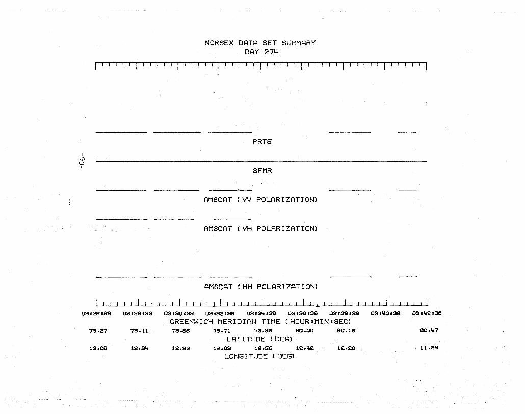
I \D o I
NORSEX DATA SET SUMMARY DAY 2711
I I II I I I I I I I I I I I I I I I I I I I I I I 1 ·"'-rT-T--rTI,-ill'-T-l-rTTTIf
PRT5
SFMR
AM SCAT CVV POLARIZATION)
AMSCAT (VH POLARIZATION)
AMSCAT CHH POLARIZATION)
03.28.38 03'28'38 03.30.38 03.32.38 03s3Q.38 03.38.38 03.38.38 03.QO'S8 03.Q2.38
GREENWICH MERIDIAN TIME (HOUR:MIN:SEC) 73.27 73. 111 73.58 73.71 73.85 80.00 80.18 80.1i7
LAT I TUDE (DEG) lS.06 12.31i 12.82 12.83 12.58 12.1i2 12.28 11.96
LONG I TUDE (DEG)
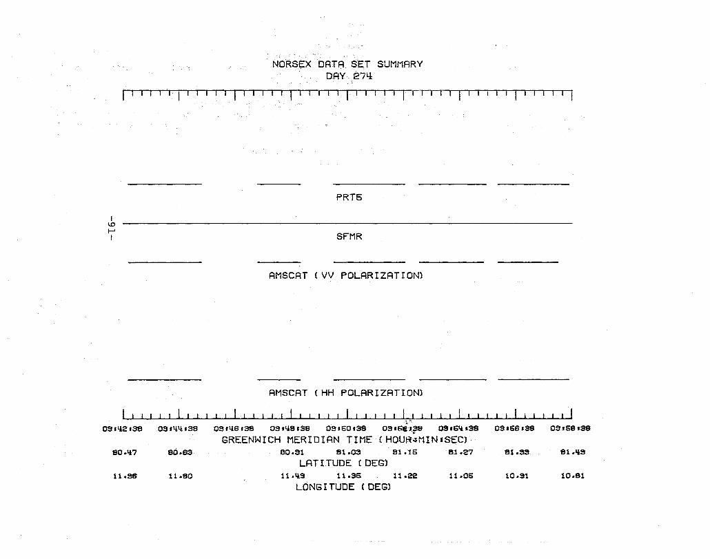
NORSEX DATASET SUMMARY DAY.274:
IT' II 11 11 11 Tl fill 11 1 I r I 111 , II 11 II r-I '1 r I I I 'I I I 1-111
I 1.0 f-' I
PRT5
SFMR
AMSCAT (VV POLARIZATION)
AMSCAT (HH POLARIZATION)
II '1 ~~;
OS.1l2.3'8 OS.LiIl.S8 OS.1l6.3'8 03.1l8.S8 OS.60.SS 03'SC'.~ OS'6Il,SS 03.68.38 OS.S8.SS
GREENWICH MERIDIAN TIME(HOUR~MIN:SEC) 80.Il7 80.as 80.S1 81.03 81.t5 81.27 81.3S Sl.ll!!.
LAT I TUDE (DEG) 11.S8 11.80 11.1l3 11.36 11.22 11.06 10.91 10.81
LONGI TUDE (OEG)
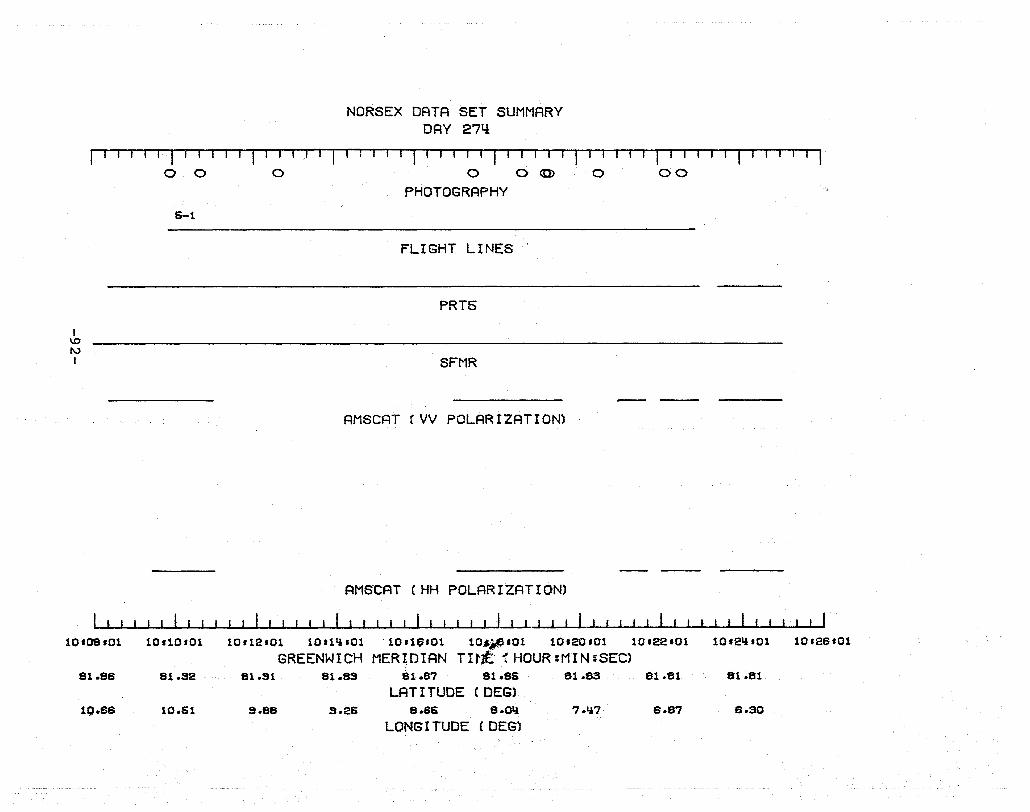
I \0 f\.)
I
10'08'01
81.88
10·68
NORSEX DATA SET SUMMARY DAY 27li
I I I I I I I.-r I I 1 II I III I I I I I I I I I I I I I rill Til
o 0 0 0 0 <0> 0 00
PHOTOGRAPHY 6-1
FLIGHT LINES
PRT5
SFMR
AMSCAT (VV POLARIZATION)
AMSCAT CHH POLARIZATION)
10'10'01 10.12'01 10'1~.0110'1~.01 10~~'01 10.20.01 10.22.01 10'2~'01 10.28.01
GREENWICH MERIDIAN TItJt t HOUR :MIN :SEC) 81.S2 81.S1 81.8S iU.S7 81.85 81.83 81.81 81.81
LATITUDE (DEG) 10.S1 9.88 9.26 8.8S e.o~ 7.lt7 S.87 S.30
LONG I TUDE (DEG)
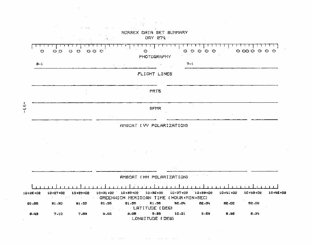
I i..O W
NORSEX DATA SET SUMMARY DRY 271.±
illfll-r-rr-rf'1' II Ii ! T i I I I 1~-riT''-rTTI~I·rluml-r·1 r--TI-r-rrTTl-r III Tl o 0000 000 0 00000 0000000
PHOTOGRAPHY
8-1 7-1
FLIGHT LINES
PRT5
SFMR
AMSCAT (VV POLARIZATION)
AMSCAT CHH POLARIZATION)
10.25.02 10'27'02 10'23'02 10s31s02 10.33.02 10135.02 10'137&02 10:3S'02 10.lilt02 101ti3.02 10.QSt02
GREENWICH MERIDIAN TIME (HDUR'MIN:SEC) 8h8S 61.S0 81 .. SS 81.-35 81.SS Sl.SS 62.01{ 82.Q'i 82.02 82.00
LATITUDE (OEG) 6.\l3 7.10 ?as S.66 3.28 s.as 10.21 9 .. 69 6 .. 96 S.Sfi
LONG I TUDE (DEG}
NORSEX DATA SET SUMMARY DRY 27!.l
rl-r~l , . I ! ! I I ITl j-T' I,-II I I I I I I I I I I I I I ! I I I I I
I 1.0 ~ I
7-1
101116'01
81.sa
7.76
o 0 0 0 0 0 0 0 0 0 0 0 0 0 0 0 0 0 0 00
PHOTOGRAPHY
8-1
FLIGHT LINES
PRT6
SFMR
AMSCAT (VV POLARIZATION)
AMSCAT (HH POLARIZATION)
101'*7.01 10lQSlOl 10151101 10163'01 lO'S6110! 10167101 10.53101 11.01101
GREENWt.CH MERIDIAN TIME (HOUR:MIN:SEC) 81.S8 81.S"l 81.~ 82.01 S2 .. 0fi 82.07 82.0S 52.11
LAT I TUDE (DEG) 7.1l.i 6.SS 6.10 6.76 7.l.iS 8.21 a.96 9.70
LONG I TUDE (DEG)
11.0S101
NORSEX DATA SET SUMMARY DAY 27~
rU
- 1 lil I-li iT I I TIl 1--1--1 l,--T r -rTl-T---rI-riJ1--rrr-r-l-IT I I
! \,0
01 I
11 .02.00 11'OlliOO
82.1S
to.IlS
00 000000000000
PHOTOGRAPHY
3-1
FLIGHT LINES
PRT5
SFMR
AMSCAT (VV POLARIZATION)
AMSCAT (HH POLARIZATION)
I 1
11.06.00 11.08100 11110cOO 11112.00 11 ct!.J:.OO 11116.00
GREENWICH MERIDIAN TIME (HOUR:MIN:SEC) 82.15 82.1S 82.12 82.10 82.08 82.05
LAT I TUDE (DEG) 9.87 3~26 B.all 8,,01 ?t.u 8.77
LONG I TUDE (DEG)
HUBsOO
82.03
S .. lll
NORSEX DATA SET SUMMARY DAY 274:
f'I ! I T,-l-lTl I-I ., T 11'-11 I ! I ! I I I I I ' I I I I I I
I IJ:)
0"\ I
11 U8'01
se.03
8 .. 13
11'20'01
82.OS
S.S9
11 122 -01
10-1.
0000000
PHOTOGRAPHY
FLIGHT LINES
PRT5
SFMR
AMSCAT (VV POLARIZATION)
AMSCAT (HH POLARI ZAT ION)
1112t.tsOl 11126,01 1.1 .2fHOl 11.30'01 11'$2101
GREENWICH MERIDIAN TIME (HOURJMIN:SEC) 82.03 81.36 61.S7 82.00 82.02 82.05
LRTT TUDE (DEG) 5.61 6.88 S.liS 7.$0 8.00 8.70
LONG I TUDE (DEG)
l1s3li '01 11.36,01
82.06 82.08
s.lie 10.1l!

NORSEX DATA SET SUMMARY DAY 27q
r--1-fll'IIT-r!IT-1-f r -1 1 I 1 I r 11 r II rrl ! r Ii 1,-, 1 !!T-r,-rT-rj
I \.0 -..,J
11-1
o 00000000000
PHOTOGRAPHY
FLIGHT LINES
PRT6
SFMR
AMSCAT (VV POLARIZATION)
AMseRT (HH POLARIZATION)
~-L~~~~~~~~~~~~~~-L~~.. I I ! I ~ 11 ,38101 11 !3fHOl 11.\iOfOl 11 -1.121101 1.1 .titHO). l1fl.!6'Ol 11 illS sOl 11.60s01 11 !52101
GREENWICH MERIDIAN TIME (HOUR:MIN=SEC) 62.08 82.02 81.33 51 • .38 81.36 81.33 81 • .91 Sl.S7
LAT I TUDE (DEG) lO.ltt 3.91 9.31 8 .. 83 8.08 7.I!3 8.82 B.3l:l
LONG r TUDE (DES)
! 1...0 00 I
12-1
11 .51.02
Sl.Sf:l
8.68
NORSEX DATA SET SUMMARY DRY 27l!
! I !! r-rrr I I ! ! I I I I I ! ('TTT-rl'T I· I I I I ! I o oooooocoo
PHOTOGRAPHY
FLIGHT LINES
PRTS
SFMR
AMSCAT (VV POLARIZATION)
~
AMSCAT (HH POLARIZATION) ... I I !! ; I I I I I
11153'02 11 S$f02 11'457'02 11.53s02 12-01'02 12,03'02 12s06'02 12'07'02 12'40!?H02 12111102
GREENWICH MERIDIAN TIME (HQUR:MIN:SEC) 81 .. '87 81.S0 81.S3 81.S6 S1.39 81.Sti 81 .. 88 81.82 tu. .. 75 a1 ~ '7il
LAT I TUDE (DEG) 7.28 7 .. sa 8.8S 9.32 10.01 10 .. 20 S.Sl 9.,56 9 .. 63 9.00
LONG I TUDE (DEG)
NORSEX DATA SET SUMMARY DRY 274:
r-1T I -Jll -, -1 111 -, 111 1 '1 J J I 1 1 lIlT T r T 1 1 IT 'TTTII
I a:..~~---.,..-., \.0
1.0 I
12.11.02
81.7q
9.00
13-1
12113.02
81.77
8.6q
am:xiiiijiiiii'iii iiiii' ii' iiii igi 'iiii ii'i' iii Ii iii: "'700 .................... ,...,.-_ ........
PHOTOGRAPHY
11!-1
FLIGHT LINES
PRT5
SFMR
RMSCAT (VV POLARIZ~TION)
AMSCAT (HH POLARIZATION)
I ( I I I I I I I I t I I ! I I I I I I
12f1St02 12.17.02 1.2113'02 12t21'02 12'23'02 12'26102 12.27102
GREENWICH MERIDIAN TIME (HOUR:MIN:SEC) 81.8S 81.95 82.011 82.13 82.22 82.23 82.25
LRT I TUDE (DEG) 8.38 8.2q 8.08 7.93 7.89 8.q8 9.08
LONG I TUDE (DEG)
I ....... o o I
NORSEX DATA SET SUMMARY DAY 274:
I I I I I I , I I I I I I I I ·r" , ... , T-l,- 'l,--rT"-l-1I11 amxo (tiHi'i' iii'i"'" 88'8'88"8 .8io x 000000000000000000000000)
PHOTOGRAPHY
111-1 15-1
FLIGHT LINES
PRT5
SFMR
AMSCAT (VV POLARIZATION)
AMSCAT (HH POLARIZATION)
12'27'03 12.23.03 12.31.03 12.33103 12136.03 12'37'03 12'33'03
GREENWICH MERIDIAN TIME (HOUR:MIN:SEC) 82.25 82.23 82.17 82.10 82.03 Sl.36 Sl.S3
LAT I TUDE (DEG) 3.0S 3.56 3.73 3.S3 3.311 10.06 10.17
LONG I TUDE (DEG)
... ~-
12,111'03 12.113103
Sl.76
10.18
i--' o i--'
NORSEX DATA SET SUMMARY DAY 274:
1 i 1 1 r-r 11 1 11rrljl i !
18-1
FLIGHT LINES
PRT5
SFMR
AMSCAT (VV POLARIZATION)
AMSCRT (HH POLARIZATION)
I ! i "
12.~$03 12t~5s03 12.~7G03 12.~3s03 12$Sl'oa 12sSSg03 12'66503 12§67s03 12'63'03
GREENWICH MERIDIAN TIME (HOURgMIN:SEC) 81 .. 76 81.78 81.80 81.81 81.81 81~76 81.75 81 ~73
LAT I TUDE (DEG) 10,,17 10.23 10.28 10~29 10.23 9.33 S.liC 8 .. 87
LONG I TUDE (DEG)
NORSEX DATA SET SUMMARY DAY 274:
r' I I I ! I I I liTI Jlll 11 I T 1 I r-,·! I I I I ~ I I I I I I I I I I I I , , I I I I I I I I I
I ~ C)
13-2
(! ,j j", j i.« j j i' i ,j 'j 'i' i" 5, j i' « i , i' i" j i j" , iii j j" i , i' ii' , i §, ii" Ii' § i j", , i' i' 'i) «"«" j jil" j J ( <8' §"'" j,'" ' i i) «'" Ii"""" j c...~I...,JUlljiJ;J! II II 11.1'11'11"" 1"111111" lligl' (~'1T££TI.~~~ C(i
NORSEX DATA SET SUMMARY DAY 274:
11 fl I '1 I I i I I I II I 1 r-l 1 If I I 1 II r 1 TIl r I Til '-I 'I -, I I , I I I --I It 1 II 1
I ~ o W I
lq-2
lSU8.014:
B2 .. 21l
8.80
13s2Q,Oii
82 .. 28
9.39
PHOTOGRAPHY
15-2
FLIGHT LINES
PRT5
SFMR
AMSCAT (HH POLARIZATION)
13$22.011 lS.~sO'i lSt_~ 13.~sOli lS'30'(Jtl 13.32.014: lS.3'l.~ lS~_.O'l
GREENWICH MERIDIAN TlMEtHOURtMIN:SEC) 82.21 82~tli R.IY1 82.00 tU.S3 81 .. fJ7 .1 .. 80
LAT I TUDE (DEli) 9.63 3.79 S .. es 10.00 10.10 10 .. el 10 .. 31
LONGITUDE (OEGl
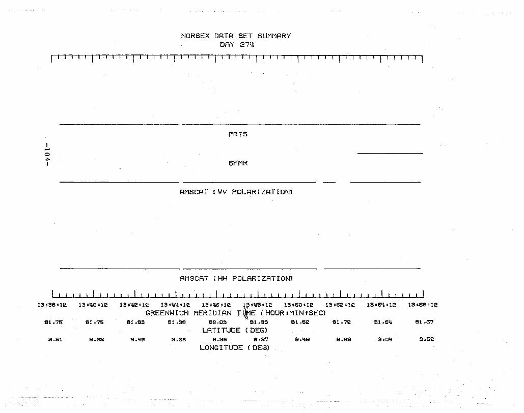
NORSEX DATA SET SUMMARY DAY 27l:l
r'T-''-'T-' ,-r-, I I I T1 I I 11 I I I '1 11 , IrTT-'
I I--' o oI:::a I
13.38J12
81.75
9.51
13 ,l:lO s 12
81 .. 75
8.33
PRT5
SFMR
AMSCRT (VV POLARIZATION)
AMSCRT (HH POLARIZATION)
13sl:l2s12 13 ,l:ll:ls12 13,l,lS.12 ~Sl:l8'12 13.50.12 13.52s12
GREENWICH MERIDIAN T - E (HOUR:MIN:SEC) 81.83 81.SS 82.03 81.S3 81.82 81.72
LATITUDE (DEG) 8.l:lS 8.35 8.36 8.37 8 .. l:la 8.63
LONG I TUDE (DEG)
13'5l:l,12 13.66.12
81.Sl:l 81.57
S.Ol:l S.52
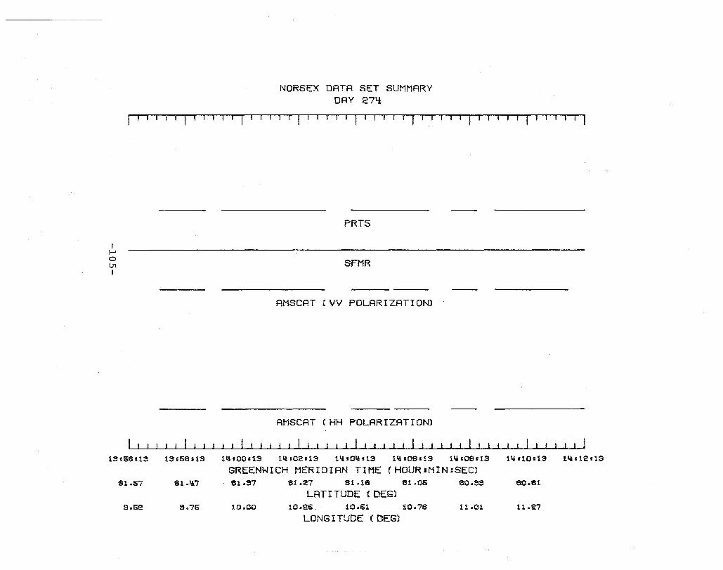
NORSEX DATA SET SUMMARY DAY 27q
jIlTT'I' I T Til I I I· 1 r I I I I· r I 1 I I -, I f1 TIIT'----r' TI II TTTl
I I-' o U1 I
1S.66.13
81.57
S.52
13e5S513
Sl.ll?
3.75
PRT5
SFMR
AMSCAT (VV POLARIZATION)
AMSCAT !HH POLARIZATION)
11!'OOH3 11:l .02t13 ll.i'OI!H3 lli '06s 13 1'4.OSU3 1'4110t13 1~H12s13
GREENWICH MERIDIAN TIME (HOURIMIN:SEC) 81.S7 81.27 SI.US 81.06 80.33 80.81
LATITUDE (DEG) 10.00 10.25 10.61 10.76 11.01 11 .. 27
LONG I TUDE (DEG)

I I-' o 0'\ I
NORSEX DATA· SET SUMMARY DAY 274:
'-'1-' . I I I I I I I I , I I I I I I I I I I I I I I I I I I I I I I I I I I I I I I I 1
PRT5
AMSCAT (VV POLARIZATION)
AMSCAT (HH POLARIZATION)
1~'12i13 1~ll~'13 1~slS'13 1~'18.13 1~.20'13 lQ.22t13 1~t2Qs13 lQ'2Ss13 lQs29s13
GREENWICH MERIDIAN T.r1E (HOUR :MIN ,SEC) eo.qs 80.30 eo~f_ 80.02 79.87 79.72 7S.55
LAT I TUDE' ( DEG) 12.OS 12.30 12.5~ 12.80 13.07 lS .. 3tl 13.81
LONG I TUDE (DEG)

NORSEX DATA SET SUMMARY DI=lY 274:
I I II I 11 I I r I I I IT I 1 II I fnr 1fT I 1 1-, I I, , fT I I TI iT' r-TTI l-TIT1I I , '1
I I-' o -...J i
11lf5$s1l6
76.31
17~OS
16101 rliS 15.0Ss1:l6
7S.71:l 76.57
17.27 17 .. 113
PRT5
SFMR
ANSCAT (VV POLARIZATION)
AMSCAT (HH POLARIZATION)
! i
16s06'116 16'07s~ 16'0$1115 15111 ,t,15 15 HS .115 lS115.I:lS 15f17.1:l6 lS.1S-tiS
GREENWICH MERtDIAN TIME (HOUR:MIN:SEC) 76 .. 110 76.22 76.05 75.as 75.70 75.52 75.311 76.16
LATITUDE (DEG) 17 .. 60 17,,77 17 .. 95 17.SS 17 .. 93 19.00 17 .. 35 17.95
LONG I TUDE (DEG)
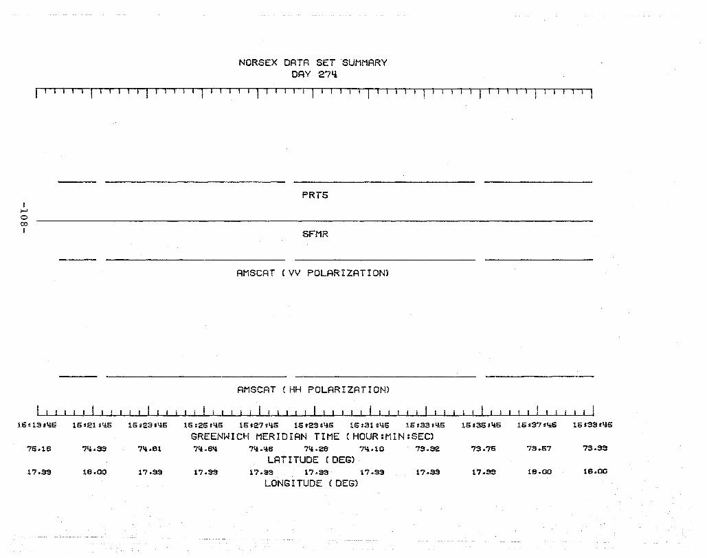
NORSEX DATA SET SUMMARY DAY 274:
I I' 1 r1 I T -. I 11-1 1 T-1 I I ml I I I 1 I 1 ' , I I I I I I I T I
I f-J o co I
1S s13 .IiS
75.16
17.99
lSs21sliS 16s23.liS
711.33 71i.81
lS.00 17.S9
PRTS
SFMR
AMSCAT (VV POLARIZATION)
AMSCAT (HH POLARIZATION)
16r26'1!6 16f27tl!6 1S'2Ssli6 16s31ili6 16s3311i6
GREENWICH MERIDIAN TIME (HOUR:MIN:SEC) 7q.6Ii 71!.1I6 7q.28 ?'l.10 73.S2
LATITUDE (DEG) 17.99 17.99 17.99 17.SS 17.S9
LONGITUDE (DEG)
16f36.1!6 16.37 filS lS,S9.liS
7S.75 73.57 73.33
17.99 18.00 lS.00

NORSEX DATA SET SUMMARY DAY 27l!
I I I I I I 1 I I I I I I I I I I I I I I I I , I I 1 I I I I 1 I I I I 1 I I -, II 1 1 --I I T '·-1
I I-' o \0 I
16s3S.qS
73.3$
18.00
16sQlll{S
73.21
17.39
PRTS
SFMR
AMSCAT (VV POLARIZATION)
AMSCAT (HH POLARIZATION)
16sQ3.QS 16sQS.QS 15.Q7t1iS 16.QS'IiS 151S1.IiS 15.S3.'lS 16t65.l{S
GREENWICH MERIDIAN TIME CHOUR:MIN=SECl 73.03 72.85 72.67 72.1i3 72.31 72.13 71.3l{
LATITUDE (DEG) 18.00 18.06 18.11 18.17 18.23 18.23 18.36
LONG I TUDE (DEG)
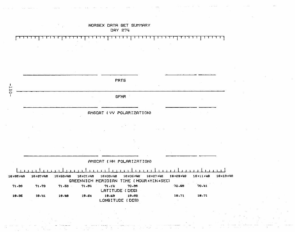
NORSEX DATA SET SUMMARY DRY 27Y:
f"11111 r 1 I IT' -11-11 r-11 1-11 1 I 1 I J J I I J 1 1 J 1 1 11 TIl r 11 1 I I I T 11 I 1
I I-' I-' o I
16.66.,*S
71.33
18 .. S6
16'67.1l6
71.73
lS.ll1
PRT5
SFMR
AMSCAT (VV POLARIZRTION)
AMSCAT CHH POLARIZATION)
16.SS.I.lS lS.011llS lS.03sllS lS.06sll6 lS'07''iS lS.0S-liS lSIlI'liS l81lS.liS
GREENWICH MERIDIAN TIME (HOUR1MINaSEC) 71.53 7I.Sli 71.11i 70.S6 70.58 70.lil
LATITUDE (DEG) 18.\\8 18.6I.l 18.6S 18.62 19.71 18.71
LONG I TUDE (DEG)

DAY 277
-111-
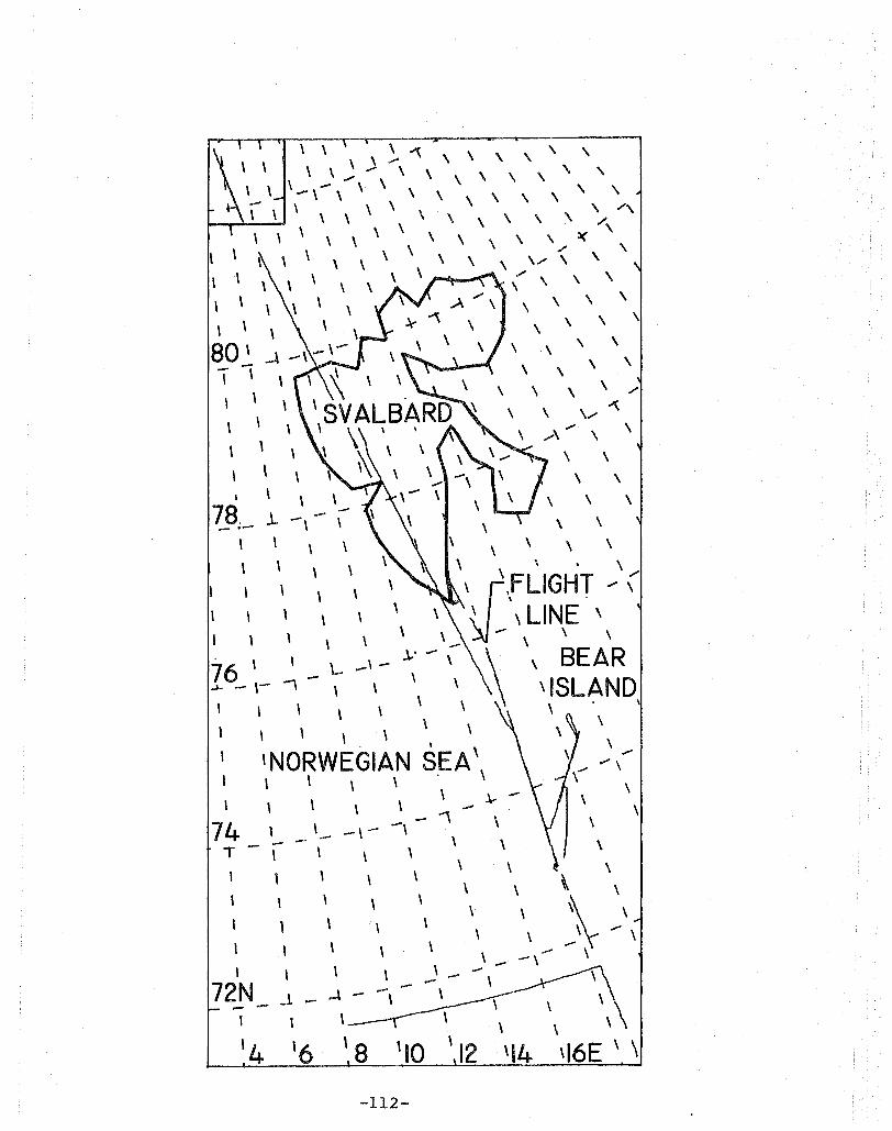
\ \ \ \ ~""\ \ \ \ " ,
\ \ \ \ \.; ..... , \ , , \ \ , ' , '-' -\ -\' ,\' \ \ \ ' ,
.--....-.-'-.11\ \ \ " \,', \ \ \ ~ /, \ \ \ \ \ \ \ \ , \ \ \ l( ,
l \ \ \ ,,\, '/, \ \ \ \,/ \ \ \ ,\ (\ \ \ \ ,
\ , , \ , \ \ \
\ \ \ \ \ \ \
80' \" "\ ,
\
\
, 78,
, , , \ \
.l.. - .-
, \ -,
\ \
\ \
\ \ , \
\ \ \
\ \ \
\ \ ,/
\ \/ ~ .... "" \ \
\ \
\ \
\ \
\ \ , , \ , ,
,
\ \., \i\FLIGHT ' ( , \ LINE \
..... \ \ , \ \ BEAR 76 \ ~-'-_\-
~ -\- I \ \\ 'ISLAND, , \ , ,\ \
1 , \ , \ \ \ , , 74
T
, 'NORWEGIAN SEA \ , \ \ , , \ , , -, ,
\ ,
'- -\, \
\ , \
\
, \
\
, -\
\
, ,
\ \ , \ ,
, - \ - -\ , 72N
--- -
, \ , J _ .4 - -,
t
'4 '6 '8 , 10 , 12 \14
-112-
-
\
\
\ , \
\ \ , \ \
-'\ ..... , ,
\ \ \ \ ' 'I6E ' \

.., 6. ~ - - -,0 \ - ..... \
83, - \ NO~EX , \ \ C -130 FLI ffiT PATH 1 \
1 OCTOBER 4~ 1979 , \ \ \
\ \ , \ \ \
\ \
\ \ \
\ \
\ , \
\ \ , \
\ , \ \
\ \ , \
\ \ \ \ \ \ ,c.il ,
\ \ " ,.., \ ,
\ ,
\ \ \ \
\ \ \
, \
l \ \
'- _ 82-\ , - \- - -\
82 - - -\--_ .. , \ , , I \
1
\
\ \ .
I> 1 q
-113-

NORSEX DRTR SET SUMMRRY DAY 277
I I I I I I I I I I I I rlTl-I~r"~lT'TTT lIT
I f-i f-i ~ I
06.21.36
70. IU
18.82
06.23.35 06126.35
70.51 70.62
18.83 18.81
SFMR
06127836 06.23.36 06831.36 06133136 06.36836
GREENWICH MERIDIAN TIME (HOUR:MIN:SEC) 70.85 70.33 71.12 71.21.i
LAT I TUDE (DEGl 18.66 18.53 18.1.i3 18.1.i6
LONG I TUDE (DEG)
06837135 05.33.36 061 1U .36
71.37 71.50 71.63
18.1.i3 18.1.i0 10.11.i
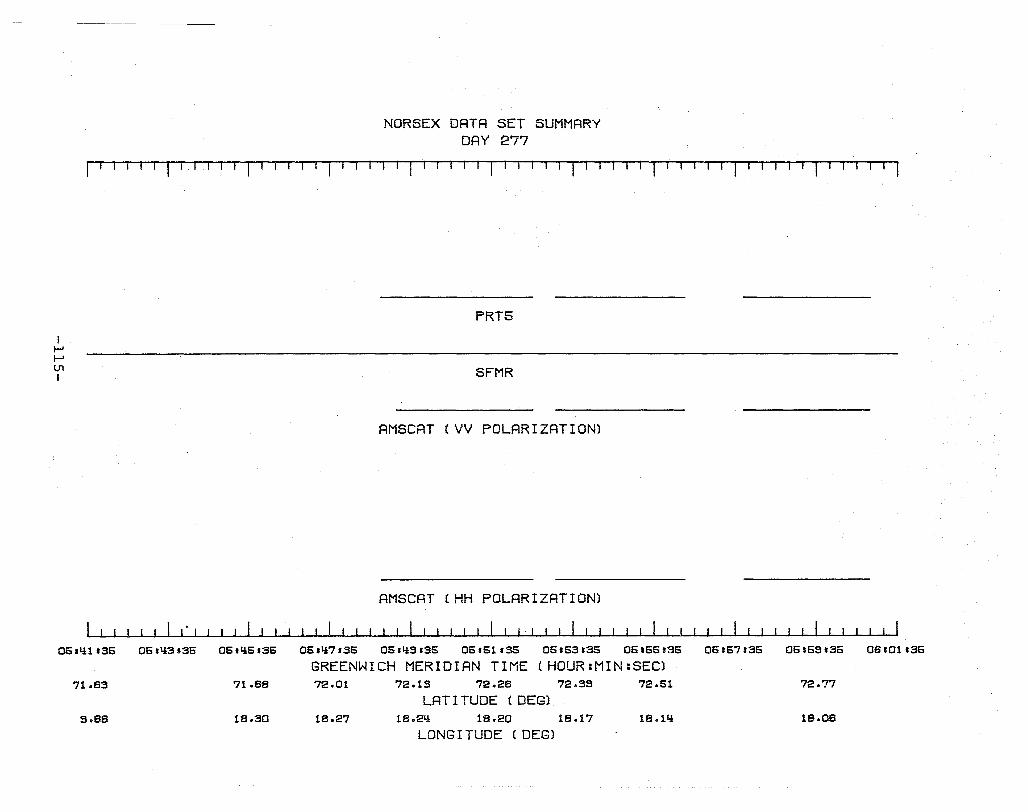
I I-' I-' U1 I
06. lil .36
71083
9.88
NORSEX DATA SET SUMMRRY DAY 277
I Tl -'--T ,-1 -1 I -. I Uj I I I I I I I I I I III T-1 T1 TUI T 1 TIlT II 1-' III
PRT5
SFMR
AMSCAT (VV POLARIZATION)
AMSCAT (HH POLARIZATION)
I I ~ I I
06.1t3s35 06.1t5.36 05.1t7.35 05.1t9135 06.51.35 05.53.35 06166.36 06.67.36 05.69,36 08.01136
GREENWICH MERIDIAN TIME (HOUR:MIN:SEC) 71.88 72.01 72.13 72.28 72.39 72.51 72.77
LAT I TUDE (DEG) 18.30 18.27 18.21t 18.20 lS.17 18.llt lS.08
LONG I TUDE (DEG)
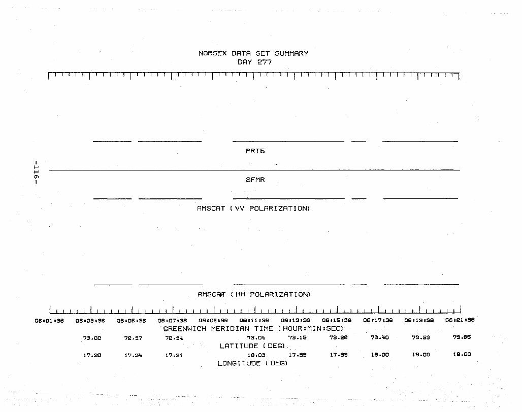
NORSEX DATA SET SUMMARY DAY 277
fT11 llTl-l 1 .-r T 1 I r11T T
I I-' I-' 0'1 I
06_01.36 06.03.36
73.00
17.98
06105836
72.97
17.91i
PRT5
SFMR
AMSCAT (VV POLARIZATION)
AMSCAK (HH POLARIZATION)
I I
06.07136 06s03.36 06111.36 06113.36 06115136
GREENWICH MERIDIAN TIME (HOUR:MIN:SEC) 72.9~ 73.01i 73.15 73.28
LAT I TUDE (DEG) 17.91 18.03 17.99 17.99
LONG I TUDE (DEG)
06117 &36 06819,S6 06821136
73.1i0 73.53 79.85
18.00 lS.00 18.00
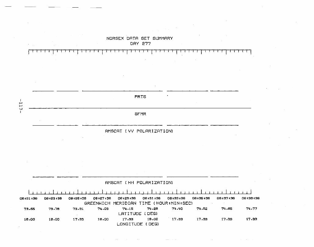
NORSEX DATA SET SUMMARY DAY 277
I-I 11-1 T r-I -{ rl -I r'i fl-l r Ti T-I-, -T ' IT rl I -r '--IT r II T· '-1 T r-' 1 r-T I fr"Tll
I I-' I-' -..J I
06s21.36
73.65
18.00
06123.36
73.78
18.00
PRT6
SFMR
AMSCAT (VV POLARIZATION)
AMSCAT (HH POLARIZATION)
06125.36 06127836 06123.36 06.31136 06133136
GREENWICH MERIDIAN TIME (HOUR:MIN:SEC) 73.31 71.J:.OS 71.J:.15 7I.J: .28 71.J:.I.J:O
LAT I TUDE (DEGl 17.33 18 .. 00 17.39 18.00 17.99
LONG I TUDE (DEG)
06.36.36 06137.36 06133136
7I.J:.52 7I.J:.65 71.J:.77
17.39 17.93 17.99
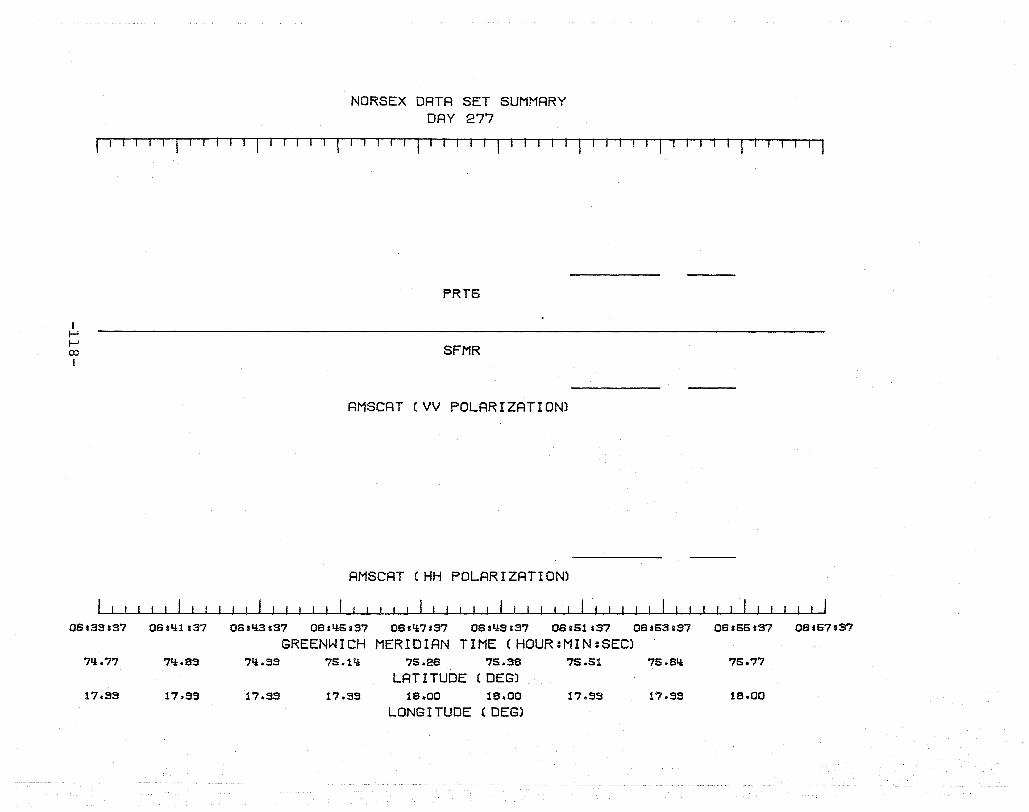
NORSEX DATA SET SUMMARY DAY 277
riTTiT rTT I I 1 I I I I II I I 1 I ITT I
I I-' I-' 00 I
OS.33.37
7li.77
17.33
OSslili37
71:1:.83
17.33
PRT6
SFMR
AMSCAT (VV POLARIZATION)
AMSCAT CHH POLARIZATION)
OS11i3.37 OSI1i6837 OSsli7.37 OSsl:l:3137 OSI61s37 OSs63137
GREENWICH MERIDIAN TIME (HOUR:MIN:SEC) 7'l.3S 76.1'l 76.2S 76.38 76.51 75.S'l
LAT I TUDE (DEGl 17.33 17.33 18.00 18.00 17.33 17.33
LONG I TUDE (DEG)
OS.65137 OS167.37
75.77
18.00
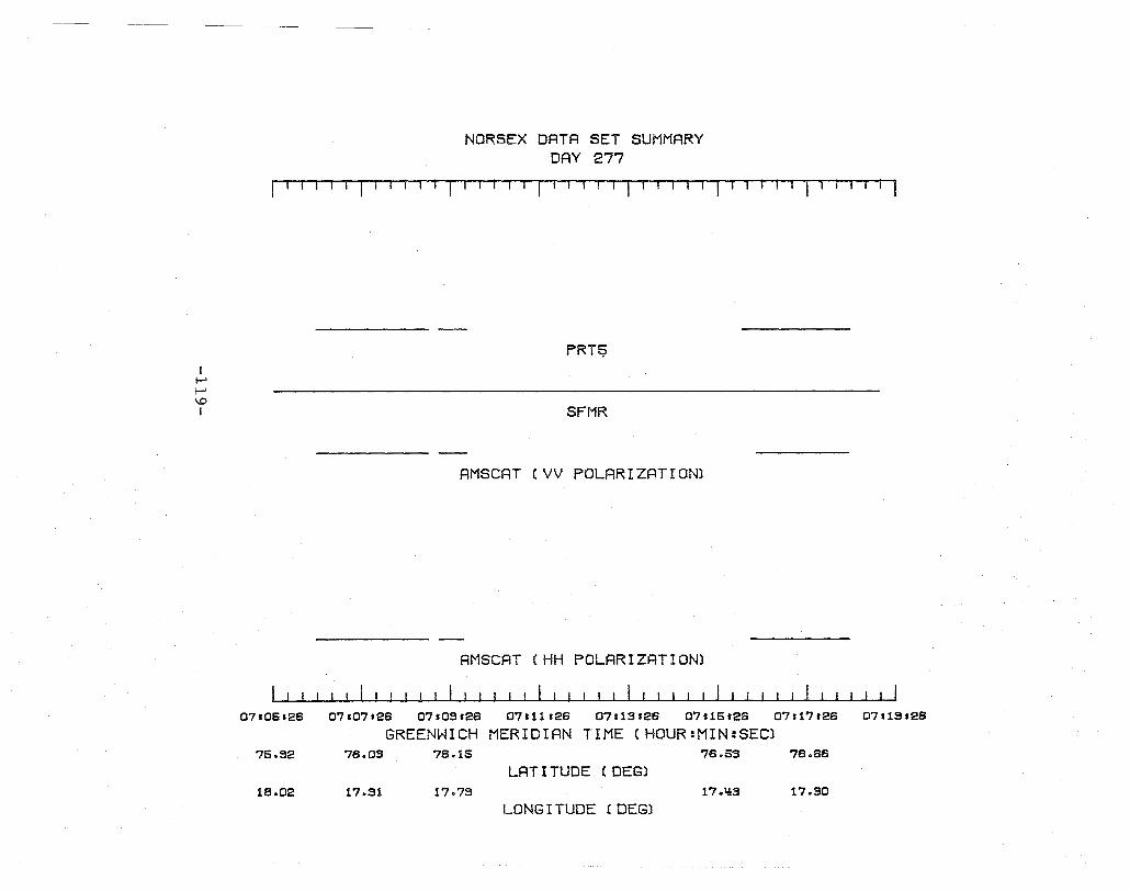
I I-' I-' \.0 I
07106128
75.32
18.02
NORSEX DRTR SET SUMMRRY DAY 277
1,'-111 -1 TT-T-r I 1 rTl I 1-'1-11111 ~l' 1 1 1-'1 T 1-'-1 -I I
PRT9
SFMR
AMSCAT (VV POLARIZATION)
AMSCAT (HH POLARIZATION)
07107.28 07109128 07111 .28 07113.28 07115.28 07s17.28 07119128
GREENWICH MERIDIAN TIME (HOUR:MIN:SEC) 78.03 78.15 78.53 78.88
LATITUDE (DEG) 17.31 17.79 17 .. ~3 17.30
LONG I TUDE (DEG)
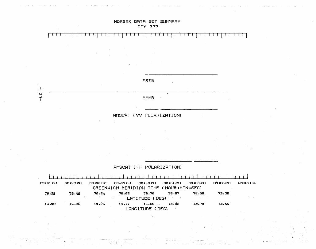
NORSEX DRTA SET SUMMRRY DAY 277
r I Til I 11 II I I 1. 1 .- I II rT 111T-r I I
I I-' N o I
OBllil.1i1
78.32
11i.1i8
OBsli3slii
78.1i2
lli.3S
PRT5
SFMR
RMSCAT (VV POLARIZATION)
AMSCAT (HH POLARIZATION)
OB.IiS.lit OBsli7ili1 OB.IiS.1i1 OB.S111i1 OBIS3tlii
GREENWICH MERIDIAN TIME (HOUR:MIN:SEC) 78.51i 7B.85 78.78 7B.87 78.S8
LAT I TUDE (DEG) 1tt .. 2S lli.l1 lli.OS 13.S2 13.78
LONG I TUDE (DEG)
DB SSSllit OB.S7.lit
7S.08
13.85
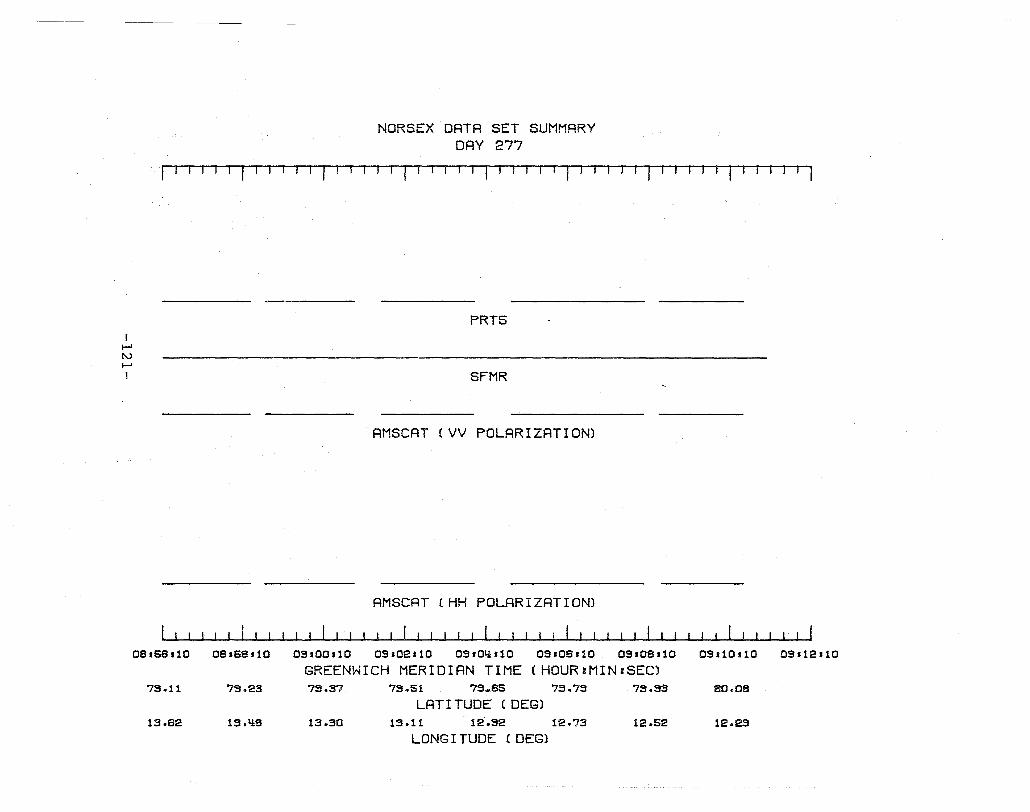
I f-' rv f-' I
NORSEX DATA SET SUMMARY DAY 277
fT I-TIl r ' , I -r 1 I' I, 1 '-1 I , J I -, /' J '-1 J I T I TIl r I T-' -'Tf-"
PRT5
SFMR
AMSCAT (VV POLARIZATION)
AMSCAT (HH POLARIZATION)
08.58.10 08168'10 OS,OOs10 OS.02110 OS.0IUI0 OS .08 .10 OS.08.10 OS,10.10
GREENWICH MERIDIAN TIME (HOUR:MIN=SEC) 7S.11 73.23 7S.37 7S.51 75,.85 7S.7S 7S.33 80.08
LAT I TUDE (DEGl 13.82 13.'18 13.30 13.11 12.S2 12.73 12.52 12.2S
LONG I TUDE (DEGl
OS.12110
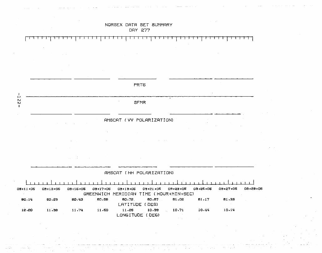
NORSEX DRTR SET SUMMRRY DRY 277
I" I -,11 I I I II r , I' I T I
I ~ N N I
OSHlI06
80.1li
12.20
09.13.06
aO.23
11.38
PRT5
SFMR
AMSCAT (VV POLRRIZATION)
AMSCAT (HH POLRRIZATION)
OS .16 106 OS .17 106 OS113.06 03.21.05 09.23.06 OS125.06
GREENWICH MERIDIRN TIME (HOUR:MIN:SEC) 80.li3 aO.58 80.72 aO.87 81.02 81.17
LRT I TUDE (DEGl 11.71i 11.60 11.26 10.99 10.71 10.lil!
LONG I TUDE (DEGl
OS.27.06 OS'29'06
81.33
10.lli
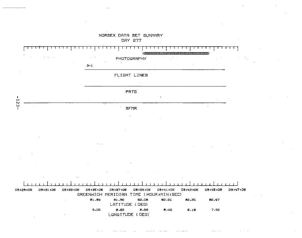
NORSEX DATA SET SUMMARY DAY 277
"-rTT-11 I I I I I '-11 ml I 1 r-111
(C££IIIIIIIIIIIIIIIIIIIII£IIIIlll[I£llll£I~~
I !-' t\.)
w I
3-1
03'2S.06 0~,31.06 03133.06 05.35.06
GREENWICH 61.eLi
9.05
PHOTOGRAPHY
FLIGHT LINES
PRTS
SFMR
0~.37r06 0~.3Ss06 OSfY:l.06
MERIDIAN TIME (HOUR:MIN:SEC) 81.S6 82.08 82.21
LAT I TUDE (DEG) 8.86 8.66 S.Y:2
LONG I TUDE (DEG)
OSrY:3.06 OS.Y:5.06
82.3Y: 62.Y:7
8.18 7.92
0~HY:7106
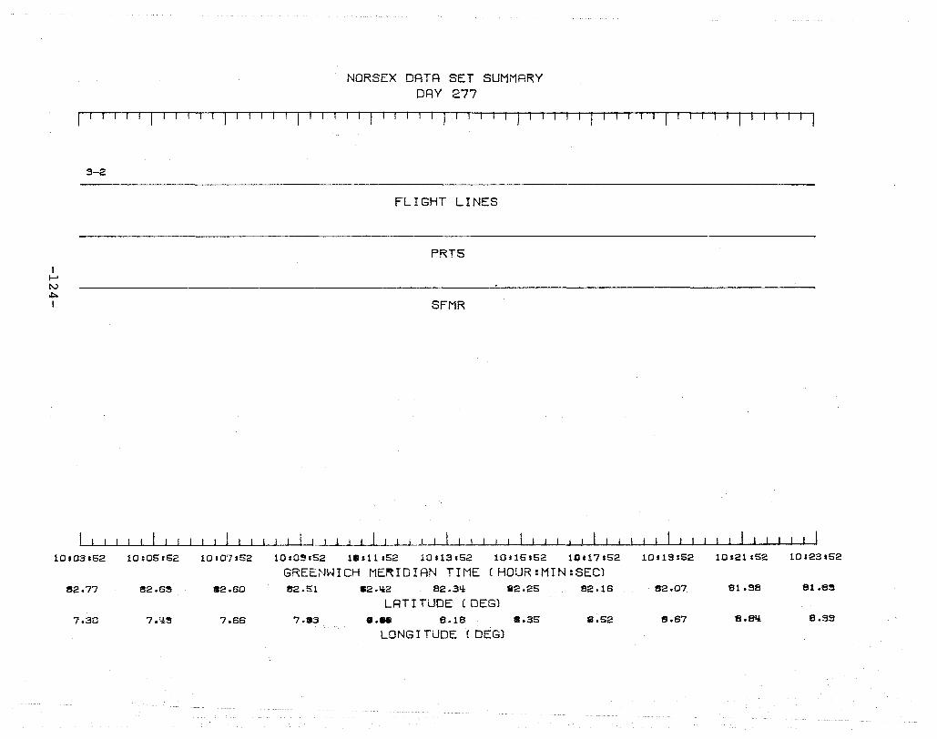
NORSEX DATR SET SUMMARY DAY 277
I'"TI--rTT rTlT'urfl . I I I T I --, I I ' I '-1 I r '
I I-' tv ~
I
3-2
10r03152
1!!2.77
7.30
10:05.52 10,07.52
1!!2.6~ 82.60
7.!f~ 7.66
FLIGHT LINES
PRT5
SFMR
1010~,52 1 •• 11152 10 t 13 .52 10 '15.52 10117.52
GREEN~ICH ME~IDIAN TIME (HOUR:MIN:SEC) 1!!2.51 a2.tt2 82.3Ll 82.25 82.16
LRT I TUDE (DEG) 7.83 8.- 8.18 8.35 8.52
LONG I TUDE (DEG)
10119 :52 10121.52 10:23s52
1!!2.07 81.S8 81.a~
8.67 a.slt 8.99
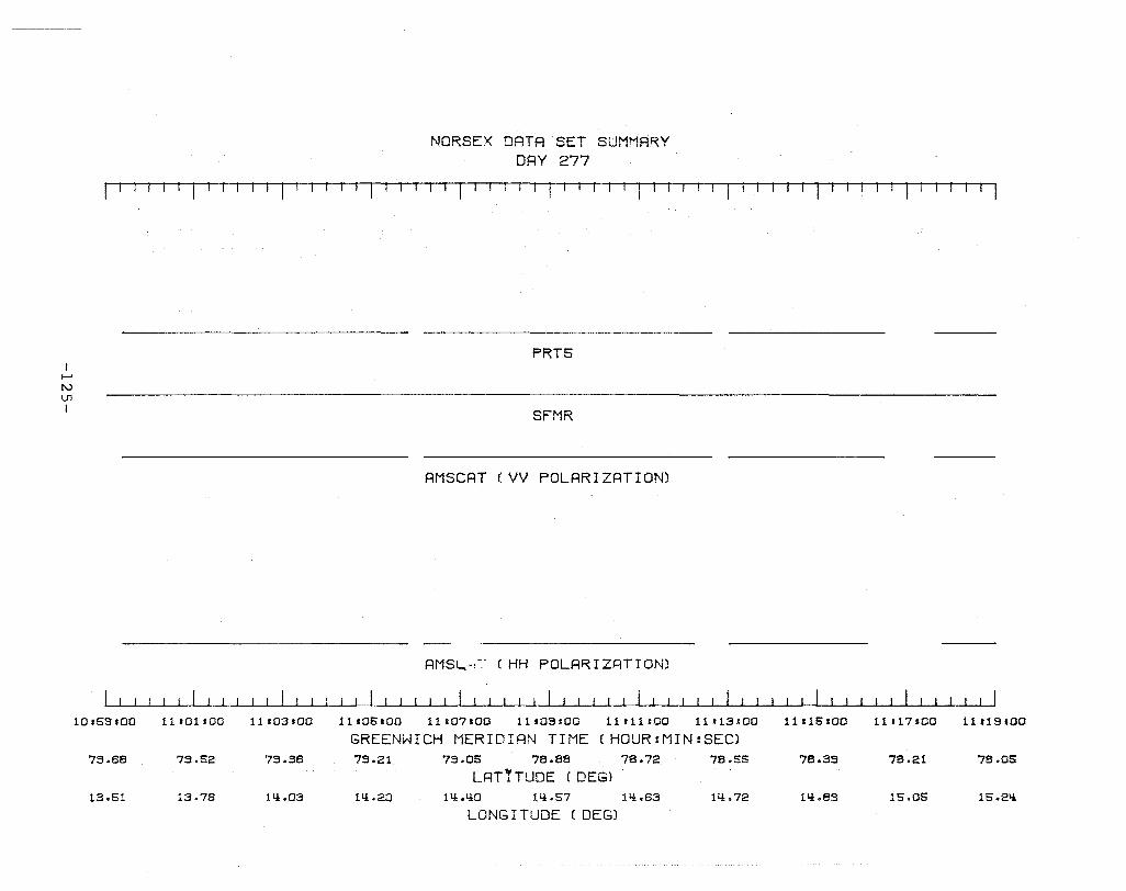
I I-' I\.)
U1 I
10.69.00
73.68
13.61
NORSE X DATA SET SUMMARY DAY 277
I-r'T iTT. I ~l T. I I I ! I 'T11I- Iii
PRTS
SFMR
AMSCAT (VV POLARIZATION)
AMSI....-:-:- (HH POLAR I ZAT rON)
11101.00 11 .03.00 11 .06.00 11107.00 11109.00 11.11s00 11113'00 11:16.00 11 J 17100
GREENWICH MERIDIAN TIME (HOUR:MIN:SEC) 79.62 73.38 73.21 73.05 78.88 78.72 78.56 78.33 78.21
LAT'TUDE ( DEGl 13.76 111.03 111.20 111.LlO 111.57 1Ll.63 111.72 1Ll.a3 15.06
LONG I TUDE (DEG)
11119.00
78.05
15.Ell
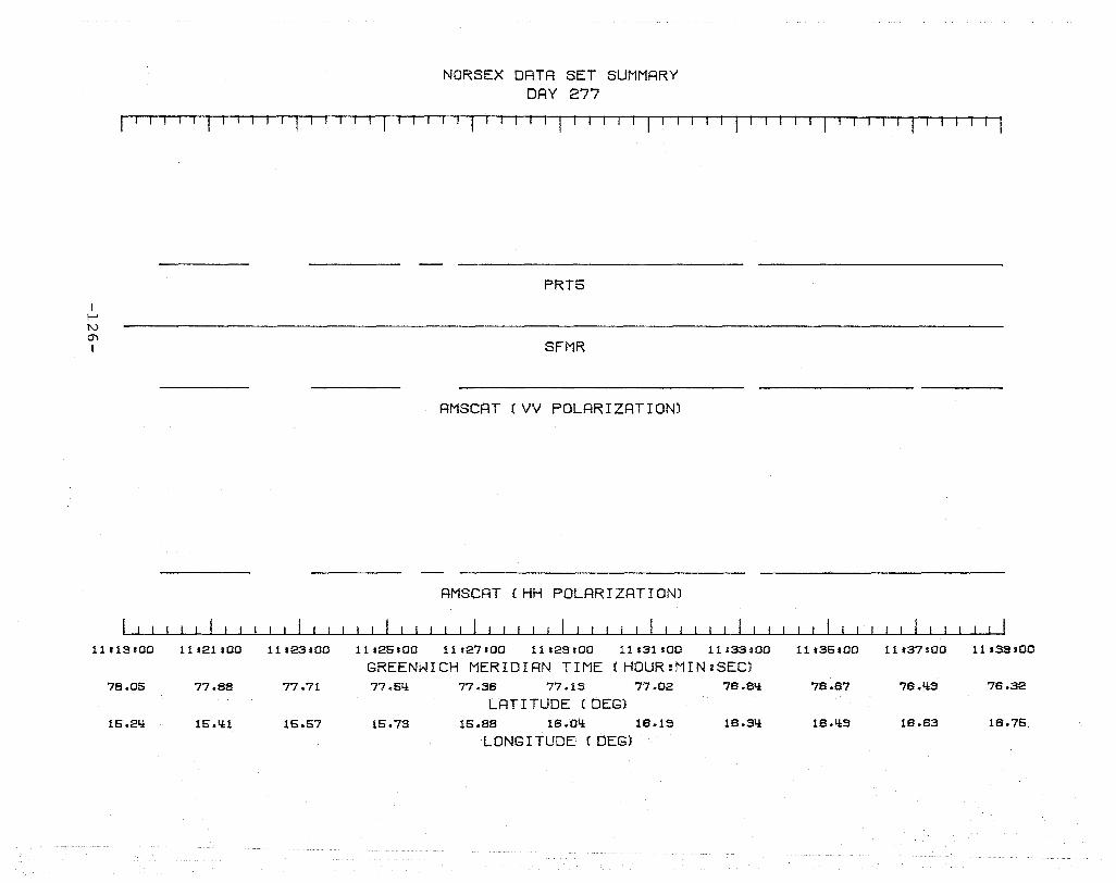
NORSEX DRTR SET SUMMRRY DRY 277
I I I II I I r I . I 1 I III I II I I I I I , I I , T I . '11
I f-' tv m I
1111~HOO
78.06
16.2!!
11'21,00 11123.00
77.88 77.71
16. IU 16.67
PRT5
SFMR
AMSCAT (VV POLARIZATION)
AMSCAT (HH POLARIZATION)
11.26.00 11 127'00 11.23.00 11.31 rOO 11 :33.00
GREENWICH MERIDIAN TIME (HOUR:MIN:SEC) 77.6!! 77.38 77.19 77.02 78.8!!
LAT I TUDE (DEGl 16.73 16.88 18.0!! 18.19 18.3!!
LONG I TUDE (DEG)
11 .36 sao 11 .37.00 UI3S .00
78.87 78.!!9 78.32
18.!!S 18.83 18.76
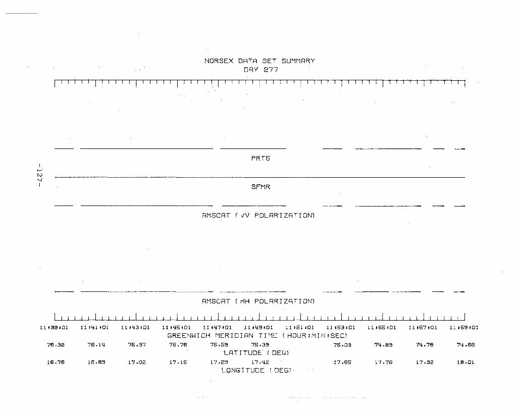
NORSE X DATA SET SUMMRRY DAY 277
fl1 TT 1 [ I ~TI-r-rlll'fT' I Tiul
I-' [\)
~
I
11133.01
76.32
16.76
11 sli1 sOl 1114:3:01
76.1L! 75.97
16.89 17.02
PRTS
SFMR
AMSCAT 'VV POLARIZATION)
RMSCAT (HH POLARIZATION)
11s4:5.01 1111i7c01 11 fli9 ,01 11:51:01 11:53:01
GREENWICH f'1ERIDIAN TIME ( HOUR:MIN:SEC) 75.78 75.69 75.39 75.03
LATITUDE ( OEG) 17015 17.29 17.4:2 17.65
LONGITUDE ( OEG)
11.55=01 11:67101 11.63.01
7li.89 7~.78 74:.66
17.76 17.32 18.01
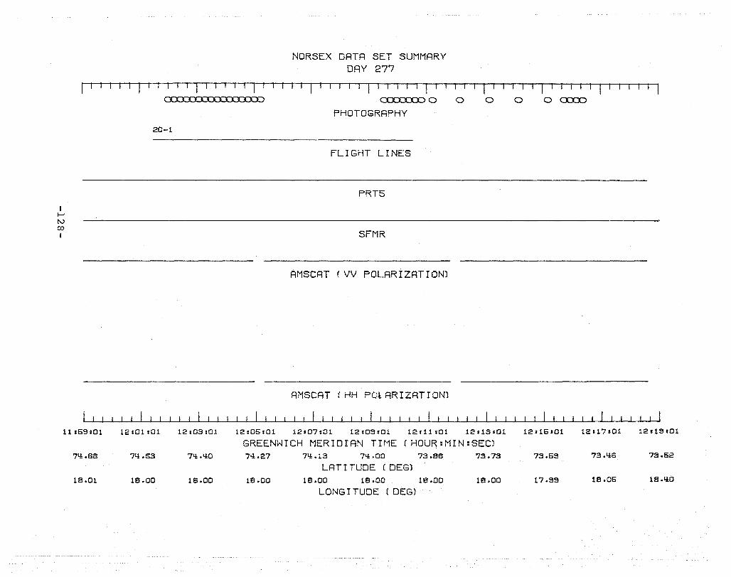
NORSEX DRTR SET SUMMRRY DAY 277
I r-11T' I' I I I I I I I I I I I ' I r-, ITT
I f-' (\.)
co I
11.69.01
7q,.66
18.01
20-1
12101s01 12103:01
7L!.63 7L!.QO
18.00 18.00
o:::J. XXJ:.D 0 o o PHOTOGRRPHY
FLIGHT LINES
PRT5
SFMR
AMSCRT (VV POLRRIZRTION)
AMSCAT CHH POlARIZATION)
12.06.01 12.07:01 12.09.01 12.11.01 12s13r01
GREENWICH MERIDIAN TIME (HOUR:MIN:SEC) 7L!.27 7Q .13 7L!.00 73.86 73.73
LAT I TUDE (DEG) 18.00 18.00 18.00 18.00 18.00
LONG I TUDE (DEG)
o o c:o::x:>
I I
12.16101 12.17101 12119101
73.69 73.q,6 73.62
17.99 18.06 18.q,0
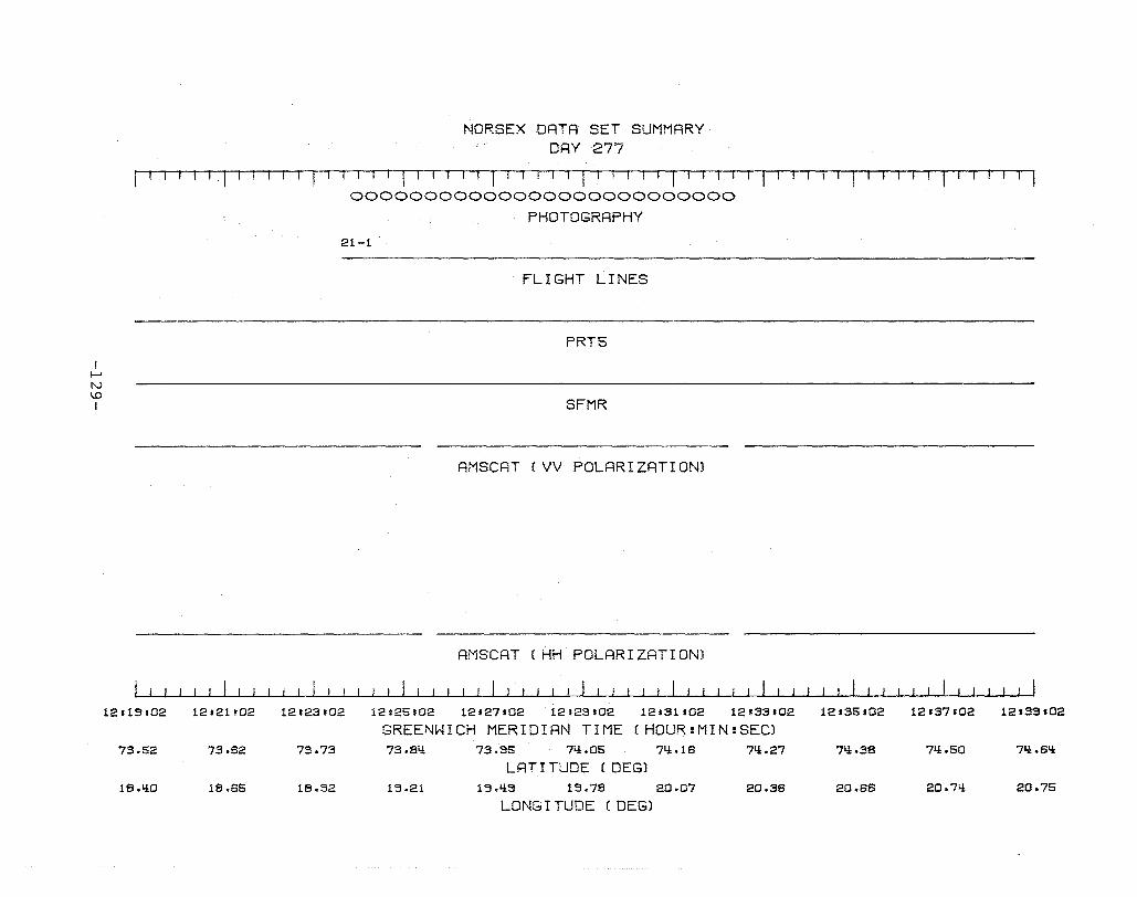
I f-> tv I.D I
12.19102
73.52
l8.liO
NORSEX DATA SET SUMMARY DAY 277
III~ fHl T '-I I I' I 1 1-11 I -1 r, 1 II II TI -T ·11· T,-T ,-1· TI I l-rTIITI T· IT r 1 1 I 00000000000000000000000000
PHOTOGRAPHY
21-1
FLIGHT LINES
PRT6
SFMR
AMSCAT (VV POLARIZATION)
AMSCAT (HH POLARIZATION)
12.21102 12'23.02 12125.02 12'27102 12s29.02 12s31.02 12s33.02 12.35.02 12.37.02 12.39.02
GREENWICH MERIDIAN TIME (HOUR:MIN:SEC) 73.62 73.73 73.8li 73.95 7li.05 7li .18 7li.27 7li.38 7li.50 71.!.8li
LRT I TUDE (DEG) 18.65 18.92 19.21 19.1i9 19.78 20.07 20.38 20.88 20.7l! 20.75
LONG I TUDE (DEG)

I I--' W o I
NORSEX DATR SET SUMMARY DRY 277
I I· 1 I 1 1 II I I I I I I I I I T I I I r T I ITTT I I I
o
21-1
12.33.02 1211.11.02
71.1.SL! 71.1.71
20.75 20.57
12.1.13102
PHOTOGRAPHY
1-1
FLIGHT LINES
PRT5
SFMR
RMSCAT (VV POLARIZRTION)
AM SCAT (HH POL~,IZATION)
I I I ! I I I I ! ! I I I I I I I i
1-2
12.1.15102 12.1.17.02 12.L!3.02 12.51.02
GREENWICH MERIDIAN TIME (HOUR:MIN:SEC) 71i.53 71i.li3 71i.33 71i.30 71i.27
LRT I TUDE (DEG) 20.58 20.66 20.65 20.li3 20.39
LONG I TUDE (DEG)
12.53.02 12.55.02 12.57.02
71i.37 71i.liS 71i.I.1S
20.65 20.83 20.89
f-' W f-' I
NORSEX DRTR SET SUMMRRY DRY 277
f 1 I 1 I I I 1 1 , I ! I I 1 1 I , I 1 1 I I r I I I 1 'i -11 rl1 I' 11 TI I rt· --r· T, T T ~-f I
21-2
FLIGHT LINES
PRTS
AMSCRT (VV POLARIZRTION)
AMSCAT (HH POLARIZATION)
12s57.03 12.59.03 13.01.03 13.03103 1:3.05103 13s07103 13s09.03 13111'03 13.13.03 13:15.03
GREENWICH MERIDIAN TIME (HOUR:MIN:SEC) 7Lt.Lt6 7Lt.37 7Lt.28 7Lt.20 7Lt.l1 71.t.02 73.3i.:l 73.85 73.77 73.70
I-RT I TUDE (DEG) 20.88 20.62 20.33 20 ¥'is 19.32 19.70 19.i.:l7 19.2Lt 19.01 18.93
LONG I TUDE (DEG)
I I-' W tv I
NORSEX DATA SET SUMMARY DAY 277
I I I I I I I ' , I , I I I I I I , I I I I I I TTl 11TII I 1
2-1
FLIGHT LINES
PRT5
SFMR
AMSCAT (VV POLARIZATION)
AMSCAT (HH POLARIZATION)
13.15.03 13 '17'03 13.13.03 13'21'03 13.23.03 13'25,03 13.27.03 13.23.03
GREENWICH MERIDIAN TIME (HOUR:MIN:SEC) 73.70 73.79 73.89 73.81 73.70 73.58 73.Q6 73.33
LAT I TUDE (DEG) 18.93 19.12 19.37 19.i:f0 19.27 19.13 18.39 18.81
LONG I TUDE (DEGl
13.31s03 13.33.03 13135s03
73.20 73.07
18.61 18.QO

DAY 281
-133-
I
'80 f - -
I , , I
?8~
GM t
1
741
72N
\ \ \ \ \
\ \ \ \ \ \ \ \
FLIGHT' \
LINES '\ \
\
I I
\
r + I
I
I
I
\ \ -\ \ \ , -_ r- --, , \
\ \ ,/
\,/ \ \ \ , \
\ \ '\ / \ \
\" \ \ \ \ \ \ \
\ \ \ \ \ \ \
\ \ \ \ \ \ \
\ \ \ "'" , "'" \"", \
\ "'" \ "" \
\
\
\ ,
\
\
\
\
\
\
1- \ -,- \ , \ \
\
\ , \ , \
I
\
\ I
\
\ \ ,
\
, \
\
\
, , \ \ \ "'"
\ "'"
\ \ "" ,"" \ \ \ "" \ "" \ \
\ ; ...... -\ \
\ -\- \ '
\
\
__ - \" \ \ \ 'BEAR -I - 1 - r - \- -\ \ \ \ \ \ IS~AN~
\ \ FLIGHT \ \ \ \ LINES\~ \ ,
, '\ \ \ \ \ \
NORW~GIAN SEA 1 \ _1_ -\ \'
I -\- \
I \ _'- -,- -\- \ \
_1- - - -\- \ \ I
I I
I
\
\ , \ , \
_1-
, ,
, , - -
, \
\
\
\
L -
\ \
\ \ \
\ \ \
\ \""" \_ ...... 'f \ \ \ \
\
\ \ --\ - -,-
\ \
\ \ \ 1114 \ 16E \ \
\ \
- 1- - - - .., \
I ,
'2 14 \6 '8 \
'10
-134-

I 2 1 0 1 2 3 4 5 6 L _82:00 I I I 1 - - r - -82:00 - - __ L I I 1- -I r - - - - - r- - ,
I
I NORSEX C-130 FLIGHT PATH \
I \ \ OCTOBER 8" 1979
\ 1 \ 1 \
\ \ \ \
I \
\ \
I I I
I
~~~v 1
l-' ~ I Y I w
f '/ ~ \ ___ ~ I \ U1 \ I
I ~ tl '0.. \ I I \ \
I I \ \ \ \ \ \ \ \
i i
\
1 \
\ I I~\j~ I I I I
-4 _ \ _ - -81:00
8 1 : OO.J - - - I _ I \ \ - -I - - - I- T \ I \ \ I
\ \
\ \ I I 4\ \ i 3 2 1 0 1 2 3 5 6 7

NORSEX DATA SET SUMMARY DRY 281
I 1 I 11 'T I r 1 Ir I IT I I ! I 1 I 1 I I r IT-III I I I
t-' W 0'\ I
05: 12 :!!2
70438
18.81i
05:1!!:!!2 05; 16 :!!2
70.50 70.63
18.83 18.82
PRT5
SFMR
RMSCRT (VV POLRRIZRTION)
AMSCRT (HH POLRRIZATION)
05: 18 :1i2 05:20:1i2 05:22:!!2 05:21i:1i2 05:26:!!2
GREENWICH MERIDIAN TIME ( HOUR :MIN :SECl 70.75 . 70.88 71.01 71.1'i 71.25
LAT I TUDE (DEGl 18.81 18.81 18.83 18.81 18.81
LONG I TUDE (DEG)
05:28:1i2 05:30:!!2 05:32:!!2
71.'i3 71.57 71.71
18.81 18.80 18.78
I ~ W -.J I
NORSEX DATA SET SUMMARY DRY 281
I ! ( ( I I I I I I I o 0 0 0 0 I TTlil I I
PHOTOGRAPHY
1-1i
FLIGHT LINES
PRT5
SFMR
05:5B:09 05:58:09 OB:00:09 OB:02:09 OB:OQ:09 OB:OB:09 OB:08:09 OB:10 :09 OB: 12 :09
GREENWICH MERIDIAN TIME (HOUR:MIN:SEC) 73.li8 73.50 73.51 73.51i 73.BB 73.78 73.90 7Q.03
LRT I TUDE (DEGl 18.67 18.63 18.57 18.59 18.62 18.68 18.67 18.57
LONG I TUDE (DEG)
I t-' W co I
NORSEX DATA SET SUMMARY DAY 281
I I I I I ! I I I 1 ., 11 1··1··' I I I I I 1 1 1 1 I I I I I 1 I 1 11 I I ' I I I I I I I , I I ,
() (OOOOOOOOOOOOOOOOOOOOOO)
PHOTOGRAPHY
I-I.!
FLIGHT LINES
PRT5
SFMR
06:12:09 06:1Q:09 06=16:09 06:16:09 08:20:09 06:22:09 06:2Q:09 06:26:09 06:26:09
GREENWICH MERIDIAN TIME (HOUR:MIN:SEC) 71.!.15 7Q.26 71.!.I.!O 71.!.52 7Q.61.! 71.!.77 71!.90
LAT I TUDE (DEG) 16.67 16.66 16.67 16.67 16.67 16.66 16.67
LONG I TUDE (DEG)
I f-' W \D I
NORSEX DATA SET SUMMARY DAY 281
I I I I I I I I I I I I I I I I I I I I I II I I I I 1 1 I· I 1 I 11 1 rT -11 .--T 1 1 I I ITl 000000000000000000
PHOTOGRAPHY
2-1
FLIGHT LINES
PRT5
SFMR
06:31:1i6 06:33:1i6 06:35:1i6 06:37:1:1:6 06:39:1:1:6 06:1:I:1:1i6 06:1:1:3:1:1:6 06:1:1:6:1:1:6 06:1:I:7:1i6
GREENWICH MERIDIAN TIME (HOUR:MIN:SEC) 75.01:1: 7'*.53 71:1:.82 71:1:.71 71:1:.65 71:1:.1:1:8 71:1:.37 71:1:.26 71:1:.1'i
LAT I TUDE (DEGl 19.66 19.66 19.66 19.66 19.66 19.66 19.66 19.67 19.66
LONG I TUDE (OEG)
I ....... ol:=> o I
NORSEX DATA SET SUMMARY DAY 281
fl,-r TT1,-1 1111 I f I I -, 1 ,-, 1 ,-1 ,,--, 11 III ITI'I--.---rT
00000000000000000
PHOTOGRAPHY
2-1 2-1
FLIGHT LINES
SFMR
08:li7:li7 08:liS:li7 08:51:li7 08:53:li7 OS:56:1i7 .08:57 :li7 08:5S:1i7
GREENWICH MERIDIAN TIME (HOUR:MIN:SEC) 71i .11i 71i.OS 73.S7 73.86 73.73 73.70
LAT I TUDE (DEG) 1~.88 1S.88 1S.66 1S.66 1S.66 1S.66
LONG I TUDE (DEG)
07:01:li7 07:03:1{7
NORSEX DATA SET SUMMARY DAY 281
1 Tl'-T -111 I I I I III III -1 11 1 TT I ITT T 1 00000000 00000000000
I f--! ~ f--! I
3-1
PHOTOGRAPHY
FLIGHT LINES
SFMR
~~~~~~~~~~~~~~~~~~~~~~J.J~~~~~~~~~~~~~ 07 :1q :S9 07:18:99 07: 18 3S9 07:20:99 07:22:S9 07teQ:99 07:28:99 07128199 07:90:99
GREENWICH MERIDIAN TIME (HOUR:MIN:SEC) 79.58 79.87 79.79 73.90 7q.02 7q.13 7q.25 7q.37 7q.q8
LAT I TUDE (nEG) 20.88 20.87 20.87 20.87 20.87 20.87 20.87 20.87 20.67
LONG I TUDE (DEG)

I t-' ~ I'V I
NORSEX DATA SET SUMMARY DRY 281
I I I 1· T T -r I I I r I I II I I I r-1 1· 11 . I I I I I I I .
000000000000 0
PHOTOGRAPHY
3-1
FLIGHT LINES
SFMR
3-2
07:30:~0 07:32:qO 07:3Q:qO 07:SS:QO 07:38sQO ~f~O:QO 07:q2:~0 07:~Q:qO 07:~8:qO
GREENWICH MERIDIAN TIME (~UR:MIN:SEC) 7~.~B 7Q.80 7Q.71 7Q.B3 7Q.5~ ; ~!': 75.07
LATt TUDE (DEG~ 20.87 20.87 20.67 20.67 20.66 20.51
LONG I TUDE (DEG)
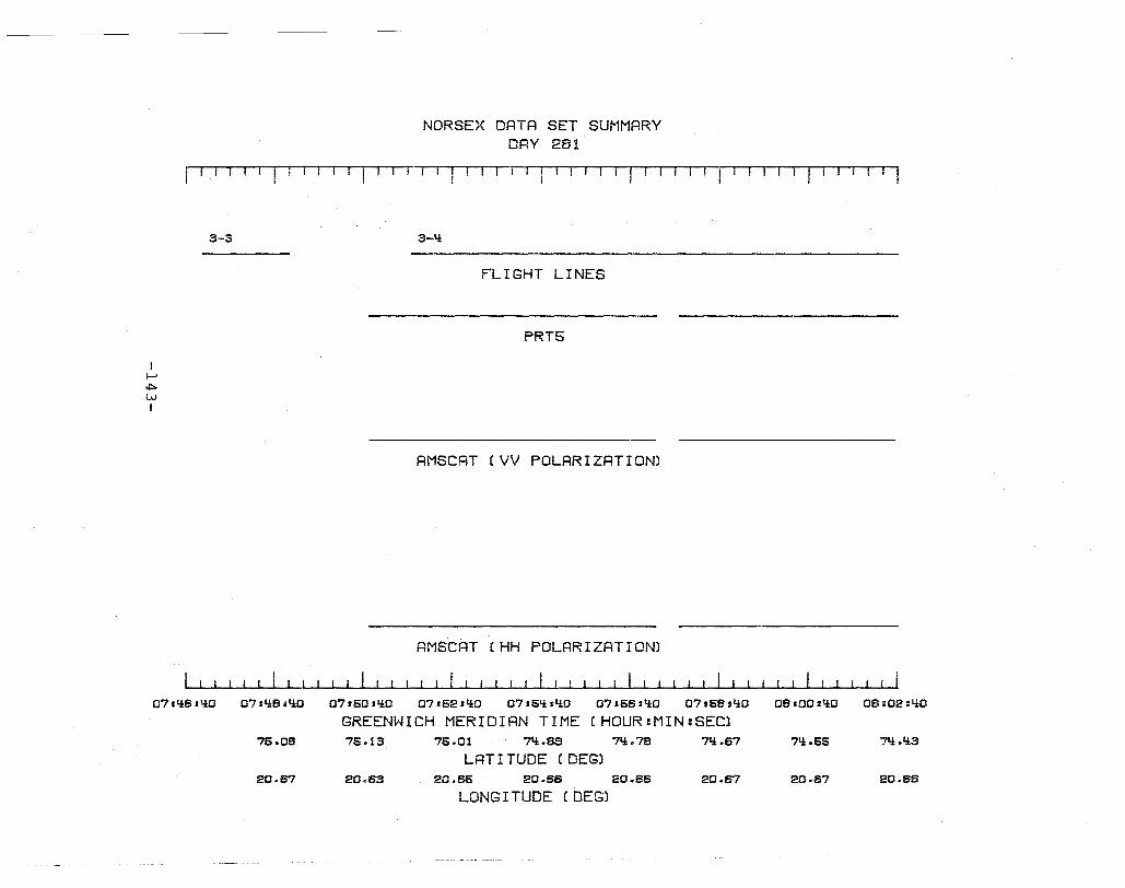
NORSEX DATA SET SUMMARY DRY 281
rill-II I I I r 11 ·,1 r '1 r - I T J -1 I-i T 11 I,-T·n T-I . T r-1 l-IT· rl -T- r T '1
I I-' ,j::.
W I
3-3
07:li8:liO 07:li8:liO
75.08
20.57
3-1i
FLIGHT LINES
PRT5
RMSCRT (VV POLARIZATION)
AMSCRT (HH POLARIZATION)
07:50:liO 07:52:liO 07:51i:liO 07 s58sliO 07:58:liO 08:00:Y:0 OSs02:liO
GREENWICH MERIDIAN TIME CHOUR:MIN:SEC) 75.13 75.01 71i.8S 71i.7S ?Ii.87 71i.55 7t.t.Q3
LAT I TUDE (DEG) 20.83 20.85 20.SB 20.88 20.67 20.67 20.66
LONG I TUDE (DEG)
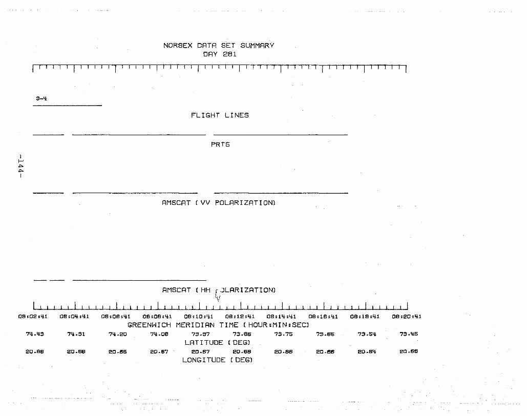
NORSEX DATA SET SUMMARY DAY 281
rJ I~T'TJJTI' 1 I I I I I I I 1 I I I I I I I I I
I ~ ~ ~ I
3-Ii
08:02:'11
71i.li3
20.66
08:0li:'i1
71i.31
20.66
08:08:'11
FLIGHT LINES
PRT5
AMSCAT (VV POLARIZATION)
AMSCRT (HH rJLARIZRTIONl iV
I ! ! I I I I I I I I , I ! I I ! I
08:08:'11 08: 10 :'11 08:12:li1 08: 1'1 :'11 08:18:'11
GREENWICH MERIDIAN TIME (HOUR:MIN:SEC) 71!.20 71i.08 73.57 73.86 73.75 73.65
LAT I TUDE (DEG) 20.65 20.67 20.67 20.66 20.66 20.66
LONG I TUDE (DEG)
08: 18 :'11 08:20:'11
73.51! 73.I!5
20.61! 20.68
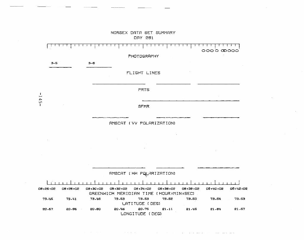
I l--' ,!::>.
U1 I
NORSEX DATA SET SUMMARY DRY 281
r llTI-r f 11 I I! I I ! I 11 I I I f I I I ! I I I 1 II I·' III I I I I I I I ! i 1 0000 (DOOO
PHOTOGRAPHY
3-6 3-6
FLIGHT LINES
PRT5
SFMR
AMSCAT (VV POLARIZATION)
RMSCRT (HH PqbRRIZATIONl ~
I I
08:2a:02 06:28202 06:30:02 06:32:02 06:~N:02 06:36:02 06:36:02 06:'i0:02 OS:'i2:02
GREENWICH MERIDIAN TIME CHOUR:MIN:SEC) 73.li:5 73.4:1 73.'ia 73.53 73.53 73.52 73.60 73.6'i 73.53
LAT I TUDE (DEG) 20.57 20.85 20.60 20.li:5 20.75 21.11 21.Y:5 21.SIi: 21.57
LONG I TUDE (DEG)
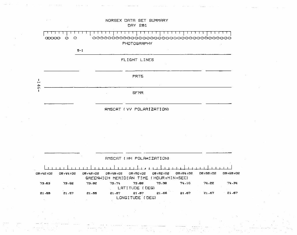
NORSEX DATA SET SUMMARY DAY 281
I I I I 1-'1' 11 ! 11 I I T I 'II , 1 T'lr-'--l ''I' 11-1 'Tillllll'I I I I ~ 0 0 000000000000000000000000000000000000
I I-' .::.. 0"1 I
5-1
PHOTOGRRPHY
FLIGHT LINES
PRT5
SFMR
RMSCAT (VV POLRRIZRTION)
RMSCRT (HH POLA~IZRTION)
~~~~~~~~~~~~~~~~~IJlL_J ~~~~~~~~~~~~~~~~ 08:li2:02 08:lili:02 08:li6:02 08:liS:02 08:50:02 08:52:02 08:5'*:02 08:56:02 08:58:02
GREENWICH MERIDIAN TIME (HOUR:MIN:SEC) 73.63 73.52 73.62 73.7,* 73.86 73.98 7,*.10 7,*.22 71i.31i
LAT I TUDE (DEG) 21.58 21.57 21.65 21.67 21.67 21.66 21.67 21.67 21.67
LONG I TUDE (DEG)
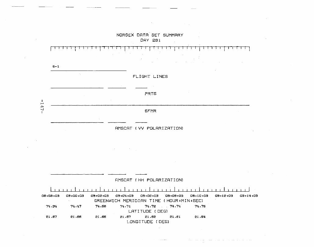
!-'
~ -...J I
5-1
NORSEX DATA SET SUMMARY DAY 281
! ---11 --r-ri 1-' -T 1, T I I Ti- fill
FLIGHT LINES
PRT5
SFMR
AMSCRT (VV POLRRIZRTIDN)
RMSCRT (HH POLARIZATION)
08:58:03 09:00:03 09:02:03 09:0q:03 09:06:03 09:08:03 09:10:03 09:12:03 09:1q:03
GREENWICH MERIDIAN TIME CHOUR:MIN:SEC) 7q.31± 7q.1±7 7q.58 7Q.71 7Q.72 7Q.7Q 71±.75
LAT I TUDE (DEG) 21.67 21.66 21.66 21.67 21.62 21.61 21.SQ
LONG I TUDE (DEG)
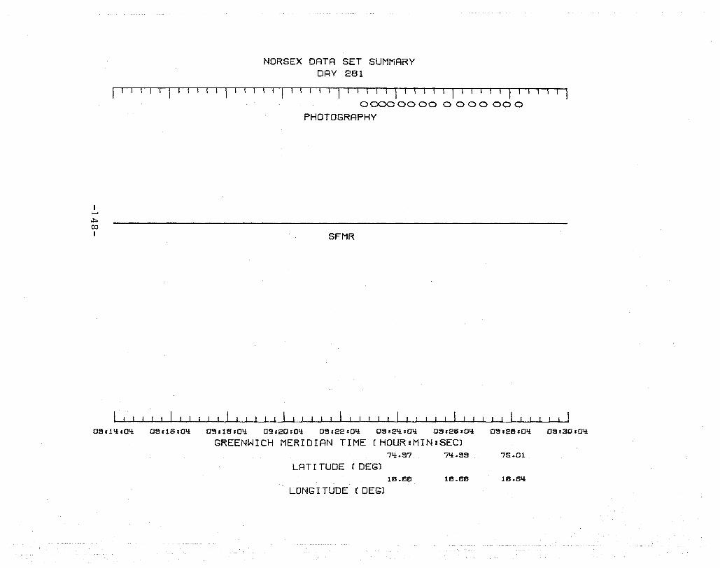
I ;.....>
~ 00 I
NORSEX DATA SET SUMMARY DAY 281
I 1 1 I I I .. I I I I I I I I I I I I I I I I I r-l-r-l I I I I I I I I ( I I I I I I I I I
00000000 0000000
PHOTOGRAPHY
SFMR
OS:1q:Oq OS:lS:0q 09:1B:Oq 09:20:0q OS:22:0Q 09:2Q:OQ OS:2S:0Q 09:28:0Q 09:30:0Q
GREENWICH MERIDIAN TIME (HOUR:MIN:SEC) 7Q.97 7Q.9S 76.01
LAT I TUDE (DEG) 18.58 18.58 18.SQ
LONG I TUDE (DEGl

NORSEX DATA SET SUMMARY DAY 281
I III II I' TiT TI' r Tli-jl-,--TTll-!
I ~ ~ \.0 I
12:08:50
78.61
11.!.20
12:08:50 12:10:50
76.62 76.73
13.85 13.\.!S
PRT5
SFMR
RMSCAT (VV POLARIZATION)
AMSCAT CHH POLARIZATION)
12:12:50 12:11.!:50 12:18:50 12: 18 :50 12:20:50
GREENWICH MERIDIAN TIME (HOUR:MIN:SEC) 76.81.! 76.SI.! 7S.06 7S.17 7S.30
LAT I TUDE (DEG) 13.12 12.71.! 12.35 U.SI.! 11.I.!S
LONG I TUDE (DEG)
12:22:50 12:21.!:50 12:26:50
7S.1.!3 7S.56 7S.69
11.01 10.53 10.02
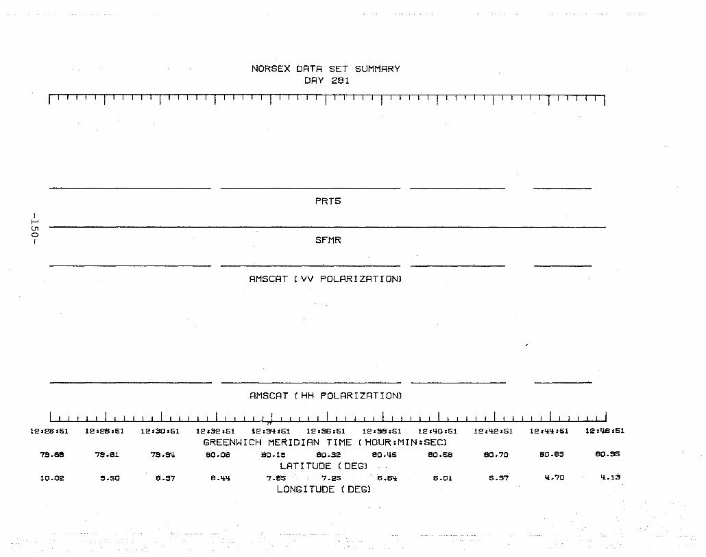
NORSEX DATA SET SUMMARY DAY 281
r I I I I I I J I I r I I TI I 1 I I I I J I I I I I I I
I I-' U1 o I
12:26:S1
7s.se
10.02
12:28:S1 12:30:S1
79.S1 79.9Q
~.SO 8.S7
PRT5
SFMR
AMSCAT (VV POLARIZATION)
AMSCAT (HH POLARIZATION)
, ! if
12:32:S1 12:3qsS1 12:36:S1 12:38:S1 12:QO:S1
GREENWICH MERIDIAN TIME (HOUR:MIN:SECl SO.06 80.15 80.32 80.liS SO.SS
LAT I TUDE (DEG) 8.lili 7.8S 7.2S 6.Sli 6.01
LONG I TUDE (DEG)
12:Q2:S1 12:QQ:S1 12:QS:S1
80.70 SO.S3 SO.56
5.37 li.70 li.1S

I I-' U1 I-' I
12sLl6:51
80.S5
Ii.13
12:Ll8:51
81.0lt
3.51
NORSEX DATA SET SUMMARY DAY 281
I ~'Tl I I I fl -11-1T I I I I 1 1 u'l-r-r-, I '1 1 -' I -rrr-I T r TI '-Tu
, I I I I I II 1
PRTS
SFMR
RMSCRT (VV POLRRIZATION)
AMSCAT (HH POLARIZATION)
12:50:51 12:52:51 12:5Ll:51 12:56:51 12:58:51 13:00:51 13:02:51 13:0Ll:51 13:06:51
GREENWICH MERIDIAN TIME (HOUR:MIN:SEC) 80.SS 81.0lt 81.12 81.20 81.26 81.33 8l.ltO 8l.lt8 81.ltS
LATI TUDE (DEG) 3.11 3.I:I:Ii 3.0li 2.61 2.22 1.78 1.33 1.08 1.52
LONG I TUDE (DEG)
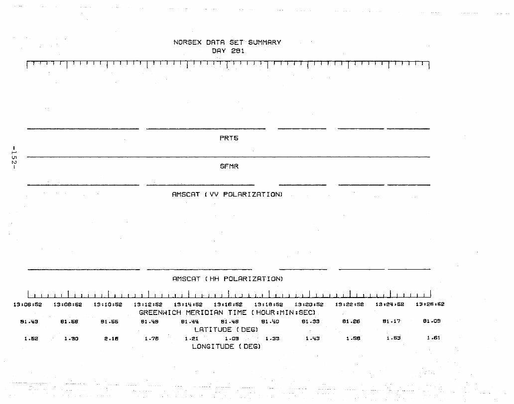
I i--' U1 tv I
13:06:52
81.'IS
1.52
NORSEX DATA SET SUMMARY DAY 281
'1' II, '1-1 1 , , T I I I , , I I II 11 , , I
PRT5
SFMR
AMSCAT (VV POLARIZATION)
AMSCAT (HH POLARIZATION)
13:08:52 13 :10 :52 13:12:52 13:1'1:52 13:16:52 13:1S :52 13:20:52
GREENWICH MERIDIAN TIME (HOUR:MIN:SEC) 81.56 Sl.55 Sl.'IS 81.'1'1 81.'16 81.'10 81.33
LAT I TUDE (DEGl 1.90 2.18 1.76 1-21 1.09 1-39 L'iS
LONG I TUDE (DEG)
13:22:52 1312'1:52 13:26:52
81.26 81.17 81.09
1.58 1.63 1.61
I I-' U1 w I
13:28:52
81.0S
1.81
1-1
13:28:52
81.12
1.25
NORSEX DATA SET SUMMARY DRY 281
!-rTT~!m-r TT I I I I I I I I II I I 1 I 1 1'1 T,m, -1 r-I I IT I Tl-l TTl T I I I I I I I (ooooooooooooooooooooooooooogoxooo§§§oooob§ooooooooooo0000000000000) ,ooooooooooooooooooooooooooooooooo~ (OOOOOOOOOOOOO')
PHOTOGRAPHY
FLIGHT LINES
PRT5
SFMR
AMSCAT (VV POLARIZATION)
AMSCAT (HH POLARIZATION)
13:30:52 13:32:52 13:3q:52 13:36:52 13:38:52 13:qO:52 13:q2:52 13:qli:52 13:li8:52
GREENWICH MERIDIAN TIME (HOUR:MIN:SEC) 81.18 Bl.2q 81.30 81.35 B1.li2 81.q7 81.63 81.69 Bl.S5
LAT I TUDE (DEG) .92 .53 .11i -.28 -.85 -1.0q -l.QI.! -1.8S -2.2B
LONG I TUDE (DEG)
NORSEX DATA SET SUMMARY DRY 281
[I-lIT I I I I I I I III I III I I I I III IT I I I I I , I I I I I I I I I I I
I f-' U1 ,j::,.
I
13:li6353
81.65
-2.28
606000000060600000600000000) (OOOOOO) (OOOOOOOO)~ (0000000000000) U.!l..R000,) COOOOOtn)~ ~ COOOOOOOO(1)OOO ~ { 00000000000001
PHOTOGRAPHY
2-1
FLIGHT LINES
PRT5
SFMR
AMSCAT (VV POLARIZRTION)
RMSCAT CHH POLRRIZRTION)
I !
13:li8:53 13:60:53 13:52:53 13:51i:53 13:56:53 13:58:53 11i:00:53 11i:02:53 lli:01i:53
GREENW!~~ MERIDIRN TIME (HOUR:MIN:SECl 81.65 81.66 81.55 81.51i 81.li8 81.li3 81.38 81.32 81.26
LRT I TUDE (DEGl -2.07 -1.65 -1.28 -.50 -.53 -.16 .21 .57 .52
LONG I TUDE (DEGl
11i:08:53
81.21
1.27
I f-' U1 U1 I
2-1
11i:OS:53
81.21
1.27
NORSEX DRTR SET SUMMRRY DRY 281
IT! T-I r1 [-1 In I r--T r lIlT rTITT'rT 1-. r--r II 11-1-T r,l-r-1ITi I-TI-Il I I II
<mmmo 0 (OOOO(iOO§ooooOo 00000000000001 Ii)
PHOTOGRRPHY
3-1 3-1
FLIGHT LINES
PRT5
SFMR
RMSCRT (VV POLRRIZRTIONl
RMSCRT (HH POLRRIZRTIONl
.\
lli:OS:53 lli:l0:53 lli:12:53 lli:lli:53 lli :lS:53 11i:18:53 lli:20:53 lli:22:53 11i:21i:53 11i:2S:53
GREENWICH MERIDIRN TIME CHOUR:MIN:SECl 81.15 81.09 81.08 81.11i 81.20 81.26 81.33 81.39 81.li5 81.50
LRT I TUDE (DEG) 1.63 1.96 2.38 2.26 1.89 1.53 1.15 .77 .38 -.02
LONG I TUDE (DEG)
I l-' U1 0\ I
NORSEX DRTR SET SUMMRRY DRY 281
I r 1 TIT 1 'T 1 1 'IT -1 r-T--rTTTI I
Rm"Y1n cmBD (nij(ggS><BBB88>no) ( 0Q00{)(}(AA8B>O<R><IDonmmOOo()[)nnJ)nooo{){x1Qoooo ) ( oomgino{)u{}igBAAgggg)no(gm) 0 rommoooooooooJGD em coooommmmooooooO(:xmooooooOOtioOoooOOOOOOO) C oOOOOoooooooooonnooOOOOO) 0
PHOTOGRAPHY
3-1 Ii-I
FLIGHT LINES
PRT5
SFMR
RMSCAT (VV POLARIZATIONl
RMSCRT (HH POLRRIZRTIONl
llia28%SIi lli:2B:SIi lli:SO:51i lli:32:51.J: lli:Sl.J:sSI.J: 11.J::S6:SI.J: 11.J::SB:SIi 11.J::1.J:0:SIi 11.J::1i2:SI.J:: 11.J::I.J::I.J:::SI.J:: 1I.J:::I.J::6:SI.J::
GREENWICH MERIDIAN TIME (HOUR:MIN:SEC) Bl.S0 51.S6 Bl.62 51.66 61.7I.J:: 61.63 61.63 61.S6 61.S2 61.I.J::7 B1.lil
LRT I TUDE (DEG) -.01 -.I.J::O -.60 -1.20 -1.07 -.67 -.26 .10 .I.J:B .6S 1.2I.J::
LONG I TUDE (DEG)
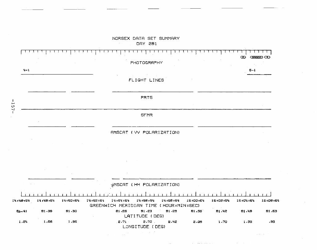
NORSEX DATA SET SUMMARY DRY 281
r-T111Tl T, T-'l" IT-j 11 IT! I T 1 1 .. \ 11 rT I 11 r'-I-Tl-~ll-T I I I I I I I I I I
I t-' U1 -..J I
'i-I
1'* : 1!B-': Sq
8.J.-'il
1.21i
11i:1i8:Sq 11i:SO:S1i
81.36 81.30
1.58 1.55
aD cmmmDCD
PHOTOGRAPHY
S-1
FLIGHT LINES
PRT5
SFMR
AMSCAT (VV POLRRIZRTION)
iMSCRT (HH POLRRIZATION)
(I
11i:S2:51i 11i:51i:51i 11i:S6:51i 11i:S8:51i 1S:00:51i 1S:02:51i 15:01i:S1i 1S:0SaSIi
GREENWICH MERIDIAN TIME (HOUR:MIN:SEC) 81.26 81.23 81.25 81.36 81.1i2 81.'i8 81.63
LAT I TUDE (DEG) 2.71 2.70 2.1i2 2.08 1.70 1.33 .53
LONG I TUDE (DEG)

I I--' U1 00 I
NORSEX DATA SET SUMMARY DAY 281
rr III r 1-11 1 r I 1 T .1-1 ''1-'-T T I I O( oomggmooooooooom){X8j<gg>oonn(jnn(){)ooo(}{lOO , <Kj()(B)ooOOOOOonoooo ) aD atmI) ammo ( m8gu)(ggiQ()ou )
PHOTOGRAPHY
5-1 5-2
FLIGHT LINES
PRT5
SFMR
AMSCAT (VV POLARIZATION)
AMSCAT (HH POLARIZATION)
15:08:55 15:08:55 15: 10 :55 15:12:55 15:11i:55 15:16:55 15:18:55 15:20:55 15:22:56 15:21i:55 15:26:55
GREENWICH MERIDIAN TIME (HOUR=MIN=SECl 81.53 81.60 81.66 81.72 81.78 81.81i 81.8S 81.83 81.78 81.72
LAT I TUDE (DEGl .S3 .51 .10 -.32 -.71i -1.18 -1.55 -1.15 -.76 -.36
t ~".lG I TUDE (DEG)

f--' Ul \0 I
NORSEX DATA SET SUMMARY DAY 281
1'1 1 I '-1 1 I T r--'r r 1 I-TT-l 1 III J I I 111 I III II III I I I r 11 I TT· III ( ,g)OOOO(xU)()OOO ) ( ()(ijBgroo()()ono() X1B'RPO OQ( n(}ooo{) ) 0
PHOTOGRAPHY
5-2
FLIGHT LINES
PRT5
SFMR
15:26:55 15:28:55 15:30:55 15:32:55 15:31i:55 15:36:55 15:38:55 15:1i0:55 15:1i2:55 15:1i!i:55 15:'i6:56
GREENWICH MERIDIAN TIME (HOUR:MIN:SEC) 81.72 81.67 81.61 81.66 81.60 81.1i1i 81.38 81.32
LAT I TUDE (DEG) -.36 .02 .38 .76 1.11.1 1.51 1.88 2.25
LONG I TUDE (DEG)

I I-' 0)
o I
16sli6:66 16:li8:66
B1.39
1.B5
NORSEX DRTR SET SUMMRRY DRY 281
f' 11 [1 r 1 I I I I J1 1
PRT5
SFMR
16:60:66 16:62:66 16:61i:66 16:66:66 16:68:66
GREENWICH MERIDIRN TIME (HOUR:MIN:SEC) B1.liS B1.liB B1 .li6 81 .li2 B1.liO
LRT I TUDE (DEG) 1.2B .52 -.05 .59 1.30
LONG I TUDE (DEG)
16:00:66 16:02:66
B1.37
2.01

DAY 283
-161-
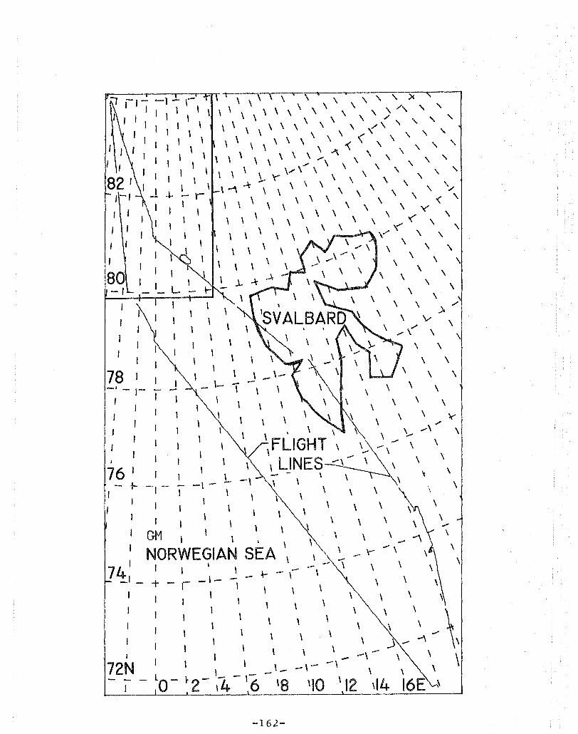
I I
I ,
I
80 -I
78 I -, -,-
I I
76 J I
of- -, - I
I
I
72N
'\\\\\ \' \ ",:>< \ \ \ \ \ \ \ ,,/, '\ '\
\ \ \ \ \ \ \ \ """,,,,,,, \ \ \ \ \ \ \ \ \ <' ",,-\ \ \ \ \ \ \ \ \"r < \ ' \ \.;\' ,,'\
\\\ \ \\\". \\ ,\ ,'\ \ ". \ \ \ '\
-I-
I
\ \ '\ \ ..... \ \ \', '\ '\ - \"" \ \ \ \ -'\ -\' , \ \ \ \ \ \ \ \ \ ,,/
\ \ \ \ \ \ \ \ \ \ \ \ 'Ie .... < '
\
\ \ \ \ .. \,' \ \ \ \ '(' \ \ \ \ ~ \ ,
\,', ,\ v,... \ \ \
\' \" \ \ \ \ \ \ \ \ \ \
.J. - \ \ --\- \ \
\ \ \ \
\ \ \ )../
\ \
,
\ , , \
\ -"\ \
\
L
\
\
\' \ \ ' \ \ \
\ FLIGHT, '--\ LINES -\ - ,
- \ \
\ \ \
\ \ , \ \
\ \ \
\ -\
\
\
, \
-162-
\
\
\
\ \ \
\ \
\
\
\
\
,
\
\
\
\
~
\
\
\
..... \
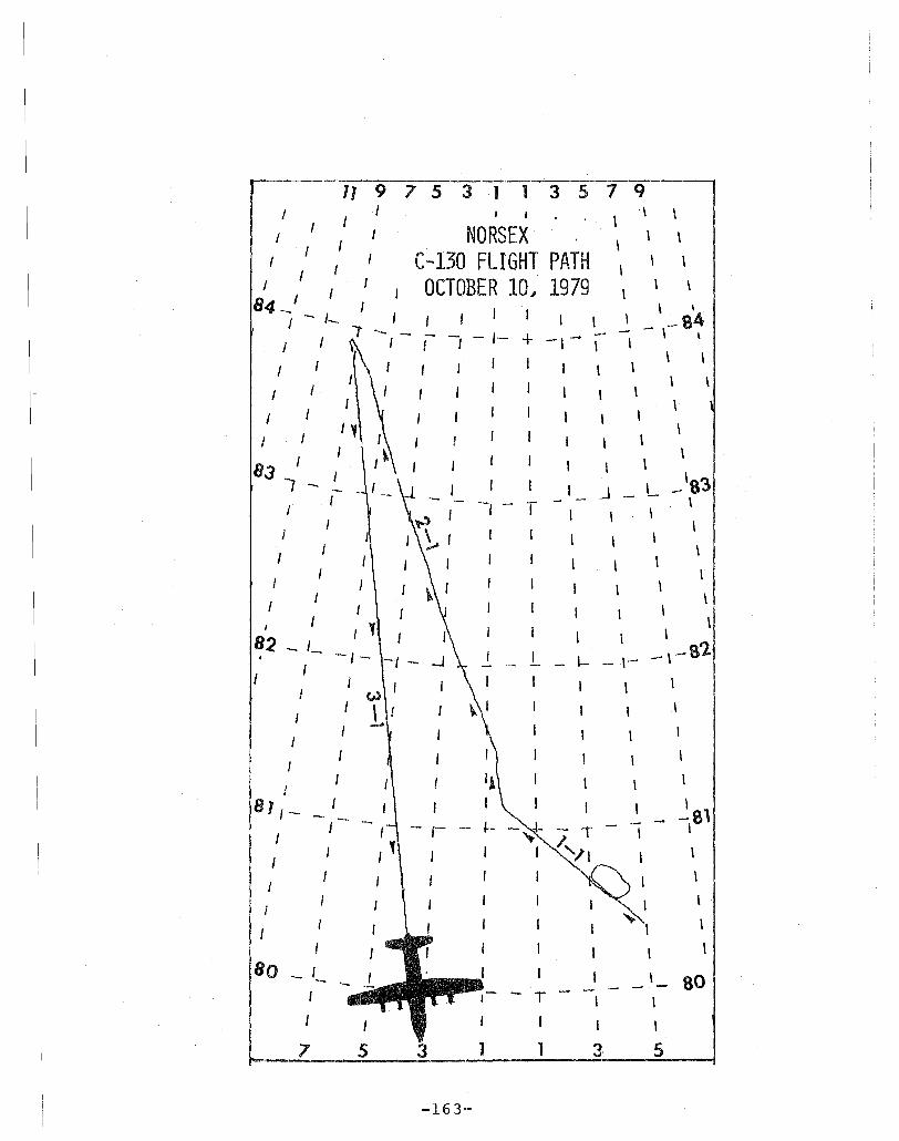
11 9 7 5 3 1 1 3 S 7 q . \
I I NORSEX \ \
I I I C-130 FLIGHT PATH \ \
I I J OCTOBER 10., 1979 \ \
I I j
84_ I , I \ \
I -. I- I I I \ \ _ \-8~ ...,. - - - -/- + .-. -I I I --, -,- I \
I I , \
I \ \
I I I I
I \ I I
, I ,
I I \ \
83 I I I
, I \
I -.. J. j I I -1 _ L. __ '83 I - "- -, - T - - \
I ,..,' I I J \
J j ~ j I \ \ J
I I I I \ I
I \ , J \ I I I \
I I I 1 I I
\ 82 _ I_ I \
_ \-- 8'2 I -(- I I - 1- - \---
I I \ w I \ I \
...... \ I \
\ J
81/_ / I \
I I- - --81 I -- r .- I \
I 1 /
I
I I
I
80 - ,- I I 80 - -I T I I
7 1 31 5
-163--

I r-' 0'\ ~
I
NORSEX DATA SET SUMMARY DAY 283
r-rrl"l r I I I I I I I I I I I I I I I I I I I I I I 1 r l-Tl r-r1-1-r 1 I--r 1 -r I r III I TTl
PRT5
SFMR
AMSCAT (VV POLARIZATION)
AM SCAT (VH POLARIZATION)
AMSCAT (HV POLARIZRTION)
RMSCRT (HH POLARIZATION)
07.26105 07.2Ss05 0'7.30s05 07s32105 07.3\.1s05 07.36.05 07,313s05 07sQO.05 0714:2105 07.\.1\.1.05
GREENWICH MERIDIAN TIME (HOUR:MIN:SEC) 71.21 71.36 71.66 71.81 71.35 72.10 72.2Q 72.38 72.52
LAT I TUDE (DEG) 13.51 lS.58 13.70 lS.77 13.83 lS.SO 1S.36 20.03 20.10
LONG I TUDE (DEG)
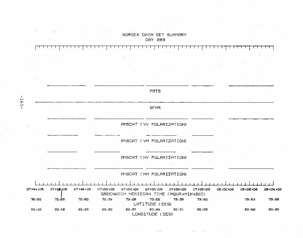
I I--' 0'1 U1 I
NORSEX DATA SET SUMMARY DAY 283
f ' I I , T I ' I , I I I I I r I '--1 I T I IT I IT I -, T f T - r
PRT5
SFMR
AMSCAT (VV POLARIZATION)
AMSCAT (VH POLARIZRTION)
AMSCRT CHV POLARIZATION)
RMSCRT CHH POLRRIZATION)
~~~~L~I~~~~~~~~~~~~~~~~~~~~~~~~~~~~~~~~~~~~~~ 07'lil!s08
?2.52
20.10
07s~el08
72e 6
20.18
07.li6:06
72.60
20.23
07.50s06 07.52.08 07s5~:08 07158'08 07.56.08
GREENWICH MERIDIAN TIME (HQUR:MIN:SEC) 72.9l! 73.06 73.22 73.38 73.50
LRT I TUDE (DEG) 20.30 20.37 20.lil! 20.51 20.59
LONG I TUDE (DEG)
06.00.08 08.02'08 oeIO~.08
73.63 '73.66
eO.liO 20.35

I I--' 0"1 0"1 I
08,01U06
73.65
20.35
NORSEX DATA SET SUMMARY DAY 293
1---'---'--'-' I-l 1- 1-1 1 I-I TIl r II 1 1 I 1 r I T,-
PRT5
SFMR
AMSCRT (VV POLARIZATION)
AMSCAT (HH POLARIZATION)
08s0S~ 08s08.06 08.10.06 08: 12 .06 08. 1 t,h 06 08.16.08 08.18108
GREENWICH MERIDIAN TIME (HOUR:MIN:SEC) 73.65 73.61 73.71 73.81:1: 73.33 ~.13 7~.27
LATITUDE (DEG) 20.1.!0 20.1:1:2 20.65 20.67 20.67 20.67 20.67
LONG I TUDE (DEG)
08.20.08 08,22.08 0812~.06
~.ti1 71:1:.65 71:1:.62
20.66 20.67 20.I:lB
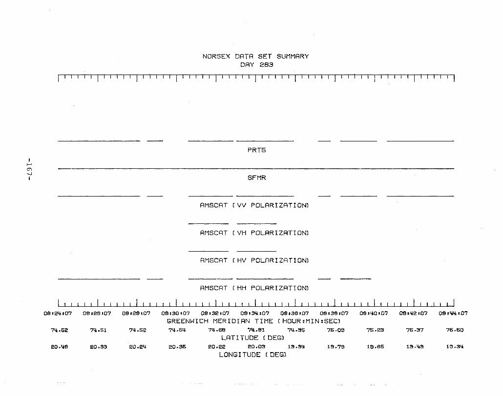
I I-' 0'\ '-.l I
NORSEX DATA SET SUMMARY DAY 263
,TTI---r I r lIJ-rTTlTTT-1 Il 'l
08.2it107 08.26s07 08.28.07
71:1:.52 7li.51 71:1:.52
eO.liS eO.33 eO.2it
08sS0s07
PRTS
SFMR
AMSCAT (VV POLARIZATION)
AMSCAT (VH POLARIZRTION)
AMSCAT f U\) l I IV POLAR I ZRT ION)
AMSCAT (HH POLARIZATION)
08sS2s07 OSsSI:I:s07 08sS6107 08.S8,07
GREENWICH MERIDIAN TIME CHOUR:MIN:SEC) 71:1:.5l! 7Q.6S '7li.81 71:1: .. S5 75.0S
LAT I TUDE (DEG) 20.35 20 .. 22 eo.os 1S.SQ 1S.7S
LONG I TUDE (DEG)
08.1:1:0107 08.1:1:2.07 0811:1:1:1:107
75.23 75.37 75.50
1S.65 IS.liS 1S.3l!
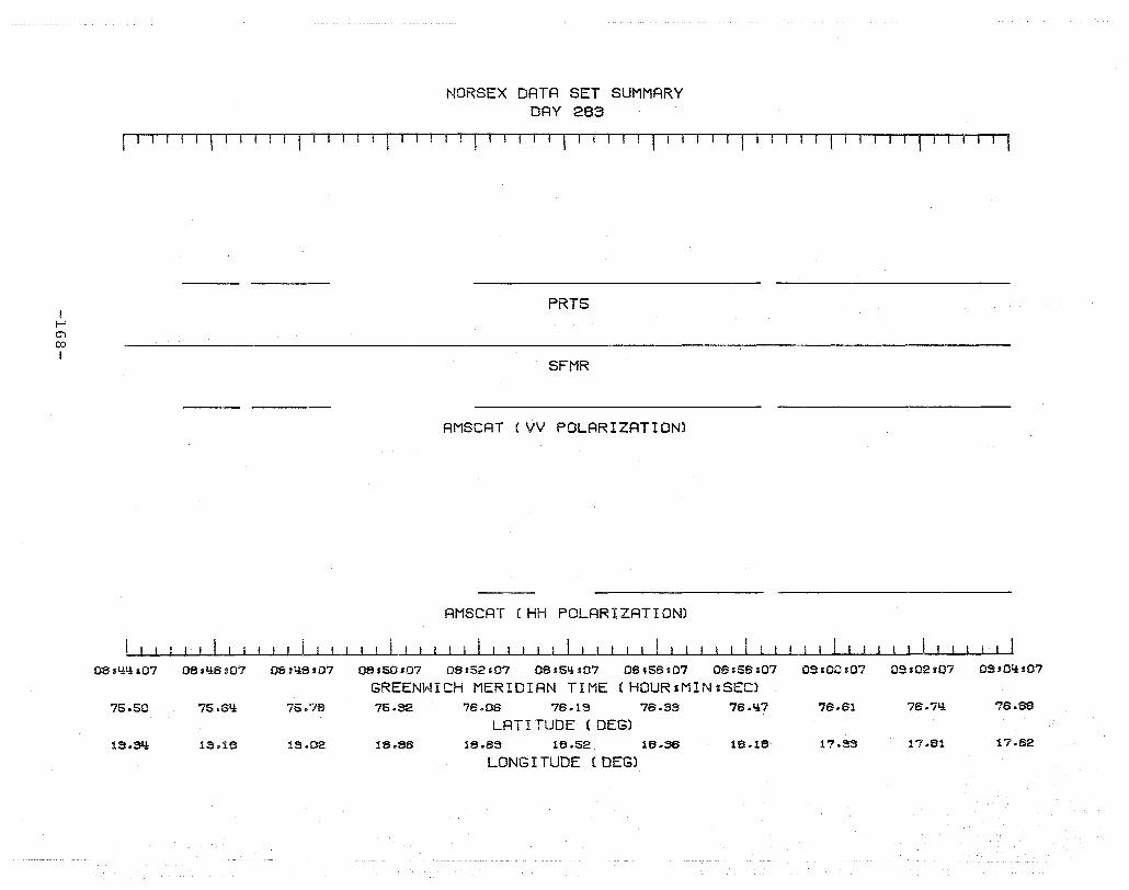
I I-' O"l 00 I
O8SY:Y:107
75.50
13.SQ
NORSEX DATA SET SUMMARY DAY 283
I TTl-Till· ITI \ I I Ii· I I I 1-rIT-T-1TI ,-I
PRT5
SFMR
AMSCAT rvv POLARIZATION)
AMSCAT (HH POLARIZATION)
I I
OBsY:6107 OS.liS,07 O8s50s07 08152.07 08154,s07 08s5Ss07 08158,07 03s00s07
GREENWICH MERIDIAN TIME (HOUR:MIN:SECl 75.6l:l 75.78 75.32 7S.0S 7S.19 76.33 76.Y:7 76.S1
LAT I TUDE (DEG) 13.18 13.02 18.8S 18.63 18.52 18.S6 18.18 17.33
LONG I TUDE (DEG)
09s02107 09 sOl:l 107
7S.7Y: 76.88
17.81 17.62
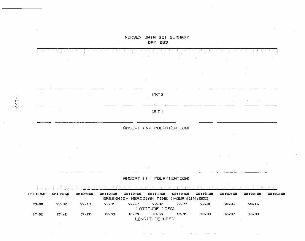
, I--' 0'\ \.0 I
NORSEX DATA SET SUMMARY DAY 283
~T-T 1 '-IT-, II TTr I I I I I I I 'I II IfTT I I ,-r-'T TTTT-rr 11-" I~I -TTl
PRT5
SFMR
AMSCAT (VV POLARIZATION)
AMSCRT (HH POLARIZATION)
I I I I! I I j --L-..I..-l---L..--L-..I..-l---L..--L-..L.-J.--L_....I..-J......j,.--'-....I..-J......j,.--'-....I..-.L........L--'-....I..-.L........L--'--'--~--L--'--L-..I.-I--....L-.JL........L--L-...I.-.JL.......L.-L-...I.-.JL.......L.-L-..J--I--'---1 QS,OIi'OO 09s061~ 09s08s0e 09110.08 09 s12.08 09.1 1H08 09116108 09.18:08 09.20,08 09122.08 OSs21i,OO
GREENWICH MERIDIAN TIME (HOUR:MIN:SEC) 76.es 77.02 77.16 77.31 77.~7 77.62 77.77 77.51 78 .OI:~ 78.15
LRT I TUDE (DEG) 17.62 17.~2 17.22 17.00 16.78 16.55 16.31 16.03 15.87 15.66
LONG I TUDE (DEG)
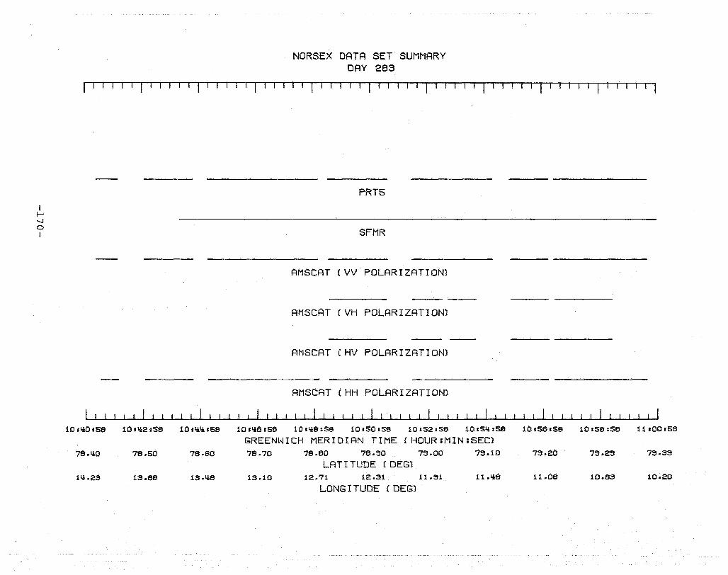
I I-' ....,j
o I
NORSEX DATA SET SUMMARY DAY 283
I I I I I I I I I I I I I I I I I I I I I I I I r I 1-, II III
PRT5
SFMR
AMSCAT (VV POLARIZATION)
AMSCAT (VH POLARIZATION)
AMSCAT (HV POLARIZATION)
AMSCAT (HH POLARIZATION)
10,'*0158 10.q2sS8 10.QQsS8 10sQSsS8 1O.Q8sS8 10sS0158 101S2:58 10sS11sSS
GREENWICH MERIDIAN TIME (HQUR:MIN:SEC) 78.~O 78.S0 78.60 78.70 78.80 78.90 73.00 73.10
LAT I TUDE (DEG) 111.23 13.86 13.116 13.10 12.71 12.31 11.~U 1l.Y:8
LONG I TUDE (DEG)
10s56.58 10sS8sS8 11.00.58
73.20 73.23 73.33
11.06 10.63 10.20

I f--J -....J f--J I
NORSEX DATA SET SUMMARY DAY 283
f' rlITl-TT-Tl TTf -1 Till I-IT r-! -1 T-I-' Til i-I
PRT5
SFMR
AMSCAT (VV POLARIZATION)
AMSCAT (VH POLARIZATION)
AMSCAT (HV POLARIZATION)
AMSCAT (HH POLARIZATION)
11 .00.58 11,02158 11.0I.H58 11 s06 s58 11 ,08.58 11 .10.58 11.12158
GREENWICH MERIDIAN TIME (HOUR:MIN:SECl 79.38 79.li9 79.71 79.82 79.92 80.03
LAT I TUDE (DEG) 10.19 9.71i 8.69 8.16 7.61 7.02
LONG I TUDE (DEG)
11 s HlS58 11.16.58 11.18.58
80.15 80.26 80.sa
6.liO 5.73 5.06

I I-' ~ N I
NORSEX DATA SET SUMMARY DAY 283
I I· I I I I I I I I I I I I I I I I I I I I I I I I I r I
PRT5
SFMR
AMSCAT (VV POLARIZATION)
AMSCAT (VH POLARIZATION)
AMSCRT (HV POLARIZATION)
AMSCAT (HH POLARIZATION)
11.18.59 11'20,59 11.22.59 11.2'i.53 11.26,59 11128.59 11.30.59 11'32'59 GREENWICH MERIDIAN TIME (HOUR:MIN:SEC)
80.38 80.li9 80·63 80.70 80.76 80.67 80.61 80.61
LAT I TUDE (DEG) 5.08 'i.3S 3.73 3.09 3.75 1i.29 1,l.\iS 1,l.1,l7
LONG I TUDE (DEG)
11 ,3'i .59 11,36.59 11.38.59
80·58 80.57 80.62
1,l.19 3.81 3.1,l3
t-' -...J W I
NORSEX DATA SET SUMMARY DAY 283
fTTr r T-rTl I I ·1 -T I I ,url I I 1- r-T I I T II f·j ITI IT1Tl IT I I I I I I I
o 00 oeo ( ooo[)()ij{){)(}[)(O) (OOOOOOOoOQaOOOOO{BB8)OO(>omSAA)o()Jt){)§{jOOMOOOQ) 0 0
PHOTOGRAPHY
1-1
FLIGHT LINES
PRT5
SFMR
AMSCAT (VV POLARIZATION)
AMSCRT (VH POLARIZATION)
AMSCAT (HH POLARIZATION)
11138IS9 11 sY:OrS9 U.Y:2IS3 11 tl.!LH59 l1sY:SsS9 11.Lt.elS9 11 'SO 159 11IS2.S9 11.SY: .S9 11.5S.S9
GREENWICH MERIDIAN TIME (HOUR:MIN:SECl eO.62 eo·se eO.7Y: eO.79 eO.8Y: 80.S8 eO.93 80.99 Sl.0Y: 81.08
LAT I TUDE (DEG) 3.l.!3 3.06 2.73 2.3S 2.03 1.68 1.31 .93 .56 .18
LONG I TUDE (DEG)
1115e.59
81.13
-.18
I f-' ~ ~
I
NORSEX DATA SET SUMMARY DAY 283
rITII'l-' r I I , I I I I I I I I I I I I 1 r-J--rl~'1IT-rl'T'TIIIT'---r11
PHOTOGRAPHY
1-1 2-1
FLIGHT LINES
PRT5
SFMR
AMSCAT (VV POLARIZATION)
AMSCAT (VH POLARIZATION)
AMSCAT CHH POLARIZATION)
11.5S,OO 12.01.00 12,03,00 12,05,00 12,07'00 12,09'00 12,11'00 12.13,00
GREENWICH MERIDIAN TIME (HOUR:MIN:SEC) 81.13 81.21 81.30 81.3S 81.liS 81.56 81.6'i 81.72
LAT I TUDE (DEG) -.18 -.37 -.'is -.56 -.57 -.SO -1.00 -1.23
LONG I TUDE (DEG)
00
12,15.00 12,17.00 12.19.00
81.7S 81.87 81.SIi
-I.IiS -1.68 -l.SIi

I f-' -..J U1 I
NORSE X DATA SET SUMMARY DAY 283
I I I I I I I I I I I I r I I I I r I I I If I I ' IT I I· r TI IT-'T'l I I I ,I I I I I I I I I I I I I I I I I I o 0 Q(dtsoo ••••• "0000000) <iF8SSAAMS_BHF __ 8JOMtj) <mBIID
PHOTOGRAPHY
2-1 2-1
FLIGHT LINES
PRT5
SFMR
AMSCAT (VV POLARIZATION)
AMSCAT (VH POLARIZATION)
AMSCAT (HH POLARIZATION)
12.19.00 12.21.00 12,23'00 12.25.00 12.27.00 12.29.00 12.31,00 12.33.00 12.35.00 12137.00 12.39.00
GREENWICH MERIDIAN TIME (HOURIMINISEC) 81.SIl 82.01 82.09 82.16 82.2li 82.31 82.39 82.1l7 82.55 82.62 82.70
LATI TUDE (DEG) -1.SIl -2.18 -2.~1l -2.66 -2.88 -3.13 -3.38 -3.56 -3."1S -1l.02 -~.28
LONG I TUDE (DEG)·
I ....... -..J 0'\ I
NORSE X DATA SET SUMMARY DAY 283
tt'-TT ·'T'·1.- T T1 r· T I I T If I I r '1 I I T r -'l--IT-r I I I I 1---rI-'-rlTl I I I I I I I I <lBmlBO <lBBD ammD~ (OQ6OD{)DOO) CD 0000(0000) aX)(D O( 000(15) GO (00000 ) (oOn!)!)
PHOTOGRAPHY
2-1
FLIGHT LINES
PRT5
SFMR
AMSCAT (VV POLARIZATION)
AMSCAT (VH POLARIZATION)
AMSCAT (HH POLARIZATION)
12.39.01 12.Y:l.01 12.Y:3s01 12.Y:5.Ql 12.':l7.01 12,Q3'01 12.51.01 12.53101 12.55.01 12.57&01 12.59.01
GREENWICH MERIDIAN TIME (HOUR:MIN:SECl 82.70 82.77 82.8Y: 82.31 82.38 83.05 83.12 83.18 83.25 83.32 83.38
LATITUDE (DEG) -Y:.28 -':l.SIl -Q.eo -5.08 -5.32 -S.SS -s.eo -6.03 -6.26 -6.Il3 -6.72
LONG I TUDE (DEG)
I I--' '-.l '-.l I
o 0
2-1
12.59.01
83.38
-6.72
NORSE X DATA SET SUMMARY DAY 283
II rl I IT I , II rl I r~rT-T~
00 0 ex:> 0
13 ,01.01 13'03,01
83.Y:5 83.52
-6.35 -7.17
O( • !)Ooo!B)oooooo 00 0 a BODO) CD
PHOTOGRAPHY
FLIGHT LINES
PRT5
SFMR·
AMSCAT (VV POLARIZATION)
AMSCAT (VH POLARIZATION)
AMSCAT (HH POLARIZATION)
13'05.01 13.07.01 13.09'01 13.11.01 13,13'01
GREENWICH MERIDIAN TIME (HOUR:MIN:SECl 83.58 83.65 83.71 83.77 83.83
LATr TUDE (DEG) -7.1.!1 -7.67 -7.89 -8.21 -8.56
LONG I TUDE (DEG)
13:15.01 13.17 sOl 13.19.01
83.89 83.33
-8.92 -9.S5
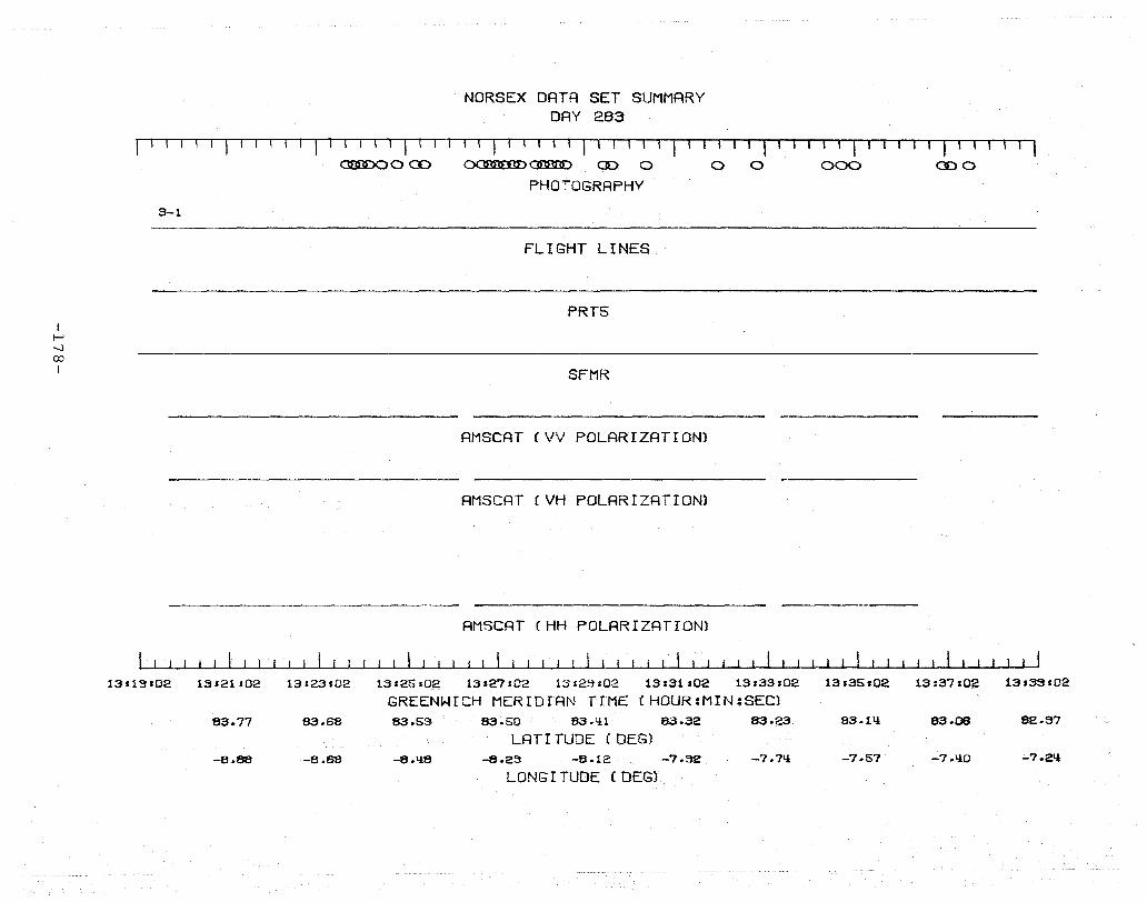
I f-' ...J 00 I
NORSEX DATA SET SUMMARY DAY 283
r·· I . T 1 ··1 1 1 1 . I ... I I· I I ! I ! I 1 I ·1 1 1 II I ·1 11 I' - I I I I I I I' I I I I I I I I I ' , <3m3DOO CD OOSoofo}<:Jl3I3DD CD 0 0 0 000 CD 0
PHOTOGRAPHY
3-1
FLIGHT LINES
PRT5
SFMR
AMSCAT (VV POLARIZATION)
AMSCAT eVH POLARIZATION)
AMSCAT (HH POLARIZATION)
1311~H02 13'21102 13.23.02 13'25:02 13.27.02 13:23.02 13.31.02 13s33.02 13,35s02 13:37102
GREENWICH MERIDIAN TIME (HOUR:MIN:SEC) 83.77 83.68 83.53 83.S0 83.1.}1 83.32 83.23 83.11.} 83.08
LATr TUDE (DEG) -8.88 -8.68 -8.118 -8.23 -8.12 -7.32 -7.711 -7.57 -7.110
LONG I TUDE (DEG)
13.33.02
82.37
-7.2'l

i-' ......J \0 I
NORSEX DATA SET SUMMARY DAY 283
r I r-l I 'I 11 I ! I I II I I IrlTl ''T-rT lI'TI--~'T---rtI
o o 0
3-1
13.33.02 13'!!! ,02 13.1.!3:02
82.97 82.88 82.73
-7.21.! -7.07 -S.32
13.1.!S.02
D 0 <JDmJDC) GmlD( Ii 0 ooooiooooo()ooo) 0 ( oooo<AA>OO<» cmm:> ammo PHOTOGRAPHY
FLIGHT LINES
PRT5
SFMR
AMSCAT (VV POLARIZATION)
AMSCAT (VH POLARIZATION)
AMSCAT (HH POLARIZATION)
13.'!7s02 13 a1.!3 s02 13.51'02 13.53.02 13.55.02 13.57.02 13.59.02
GREENWICH MERIDIAN TIME (HOUR:MIN:SEC) 82.70 82.S2 82.51.! 82.liS 82.38 82.30 82.22 82.15
LAT I TUDE (DEG) -6.77 -6.62 -6.50 -6.37 -6.26 -6.1ll -S.OO -S.8S
LONG I TUDE r DEG)

I I-' 00 o I
NORSEX DATA SET SUMMARY DAY 283
r -, r -T '-1 r I T 11 , I I I I I I I I I I I I I I I f 1-' TTl I I I I I I I-II 1-' I I
( uOOUQb®Q{)o®!) OcmBSD aD cmD ( 000000 ) <m:B'D cmmmD
PrlOTOGRRPHY
3-1 3-1
FLIGHT LINES
PRT5
SFMR
AMSCAT (VV POLARIZATION)
AMSCAT (VH POLARIZATION)
AMSCAT (HH POLARIZATION)
13.59:03 lll.01:03 11!r03r03 1l!'05r03 IQr07.03 II! rO~HO~ 11,1 r11103 lIH13s03 111 r 15:03
GREENWICH MERIDIAN TIME (HOUR:MIN:SECl 82.15 82.07 82.00 81.32 81.81! 81.76 81.69 81.61 81.51!
LRT I TUDE (DEG) -5.89 -S.79 -5.69 -5.S8 -S.'!7 -S.37 -5.28 -5.18 -5.09
LONG I TUDE (DEG)
111.17103 111119.03
81.116 81.33
-'!.99 -11.89
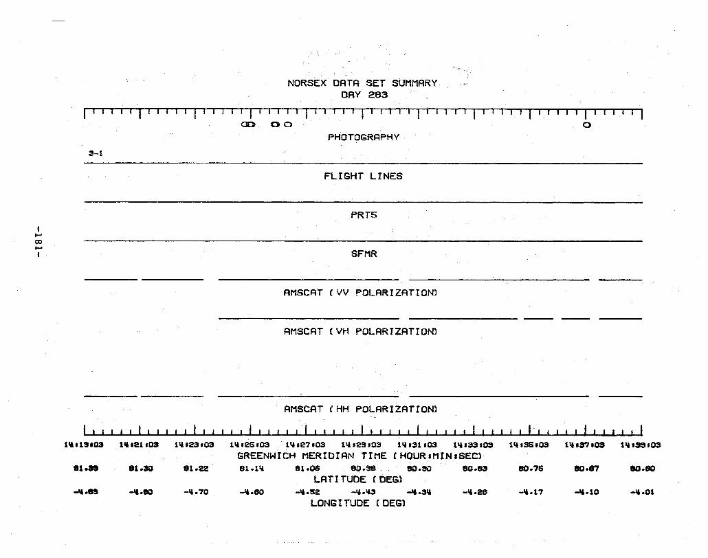
I ~
ex> ~
I
NORSE X DATA SET SUMMARY DAY 283
rIll T'II TTl Tl'- 1-1 --'1 Ir-T I r '1· rTf T-'1T-"'--'-T'T' Til I I I I
00 00 0
PHOTOGRAPHY 3-1
FLIGHT LINES
PRT5
SFMR
AMSCAT (VV POLRRIZATIONl
AMSCRT (VH POLARIZATION)
AMSCAT CHH POLARIZATION)
111.1S.03 111.21.03 1,&.23'03 1,&.2S.03 1,&.27'03 Ill.29.03 1".31.03 1".33.03 1,&.35.03 1".37'03 GREENWICH MERIDIAN TIME CHOURIMINISEC)
81.as 81.30 81.U 81.111 81.08 eo.se eo.so eo.as 80.75 80.87 LATITUDE (DEG)
-'I.n -II.eo -ll.70 -11.80 -II.S2 -ll.1A3 -'1.3'& -,&.28 -11.17 -'1.10 LONG I TUDE C DEG)
1,&.39.03
80.80
-11.01
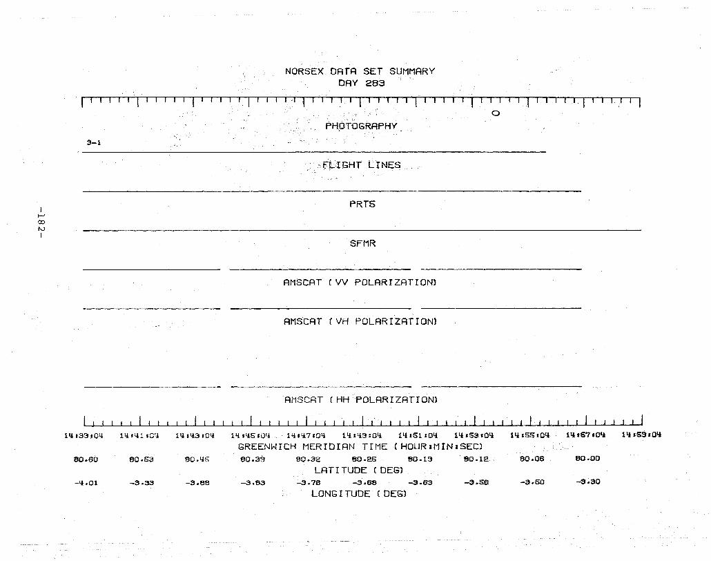
I i-' 00 I'V I
NORSEX DATA SET SUMMARY DAY 283
fTrr,-r-l I I I I 'I ! "11,-1 I I I 1'll'l'-:~1 r-T-'--TT'T II' o
PHOTOGRAPHY
3-1
ft.l GHT L r NE8..
PRTS
SFMR
AMSCAT (VV POLARIZATION)
AMSCAT (VH POLARIZATION)
AMSCAT (HHPOLARIZATION)
Ilj.33.0li 11!,'!!.sOI! tli,1!3.01! lli.IiSIOI! lli.1!7'01! 11!.1!9;01! 11i.St.OI! lli,53.0'! 1'!s55.01!
GREENWICH MERIDIAN TIME (HOUR:MIN:SEC) 80.60 80.53 80.1!5 80.33 80.32 80.25 80.13 80.12 80.06
LAT! TUDE (DEG) -1l.01 -3.33 -3.00 -3.83 -3.76 -3.68 -3.63 -3.56 -3.50
LONG I TUDE (DEG)
11i.57.01i 11!.5S'0'i
80.00
-3.30
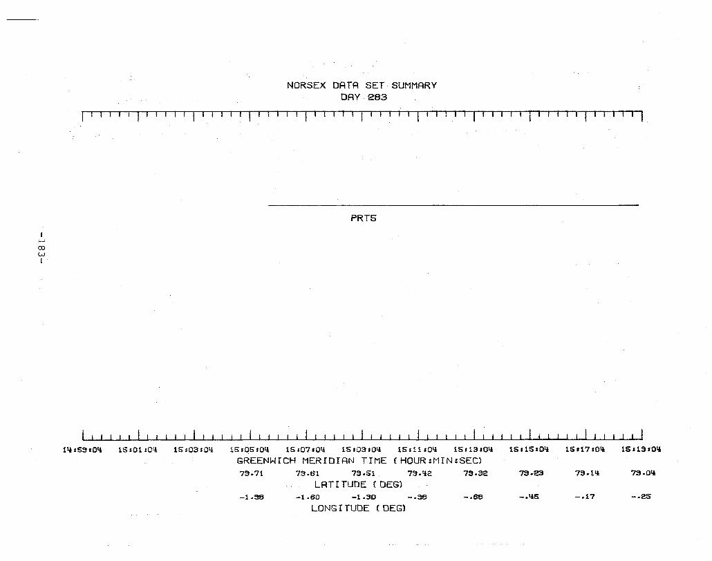
I I-' 00 w I
111.53.011
NORSEX DATA SET SUMMARY DAY 283
II-lIIT-TTTT'l I I I 1 I 1 1 II I I I I T1ITT' I I I Ill-rTTT i I I I Il-rrT'-' I I
PRT5
15,01 sOl! 15=03s011 15,05:011 15'07.011 15,03:011 15,11 'Oll 15,13 ,Oil 15,15.011 15'171011 15,19,011
GREENWICH MERIDIAN TIME (HDUR:MIN:SEC) 73.71 73.61 73.51 73.11i:! 73.32 73.23 73.11l 73.011
LATI TUDE (DEG) -l.~ -1.60 -1.30 -.38 -.68 -.'15 -.17 -.25
LONG r TUDE (DEG)

I f--J 00 ..!:::o I
NORSEX DATA SET SUMMARY DAY 283
1'1 I I I If' 11 I I' I I I I I' r I I I I' lll'l-rl
PRTS
SFMR
AMSCAT (VV POLARIZATION)
AMSCAT (VH POLARIZATION)
AMSCAT (HV POLARIZATION)
AMSCAT (HH POLARIZATION)
15 ,19.05 15,21,05 15,23'05 15.25'05 15:27:05 15,29'05 15,31:05 15:33:05
GREENWICH MERIOIAN TIME CHOUR:MIN:SEC) 79.0'l 76.95 76.65 76.75 76.65 76.5'l 78.'l2 78.31
LATr TUDE (DEG) -.25 .06 .118 .30 1.30 1.72 2.15 2.55
LONG I TUDE (DEG)
15:35:05 15.37:05 15:39s05
76.19 78.07 77.95
2.96 3.38 3.79
f-' CO U1 I
NORSEX DRTA SET SUMMARY DAY 283
r T I··! . r'T'I,·-r -fl· T ·' ··'rTT Ti · T,-r -l-r \II--r-rr-T'I
PRT5
SFMR
AMSCAT (VV POLARIZATION)
AMseAT (VH POLARIZATION)
AMSCAT (HV POLARIZATION)
ANSCAT (HH POLARIZATION)
15s39105 15.1,l1,05 15sl,l3s0S 15:I!S:05 15,117:05 15s119 ,05 15:51s05 15,53105
GREENWICH MERIOIRN TIME CHOUR:MIN:SEC) 77.95 77.83 77.70 77.58 77.115 77.33 77.19 77.06
LRTI TUDE (DEG) 3.73 11.20 11.53 11.98 5.36 5.71{ 6.12 6.50
LONG I TUDE (DEG)
15,55,05 15157.05 15159,05
76.92 76.78 76.63
8.68 7.27 7.&l
I i-' 00 0'1 I
NORSEX DATA SET SUMMARY DAY 283
rTITITl' TI r-1TT, TlTT,TI-r1i" I I .----r
PRT5
SFMR
AMSCAT (VV POLARIZATION)
AMSCAT (VH POLARIZATION)
AMSCAT (HV POLARIZATION)
AMSCAT (HH POLARIZATION)
15,53,06 16,01 s06 16'03:06 16:05.06 16.07'06 16s03s06 16'11 ,06 16:13,06
GREENWICH MERIDIAN TIME (HOUR:MIN:SEC) 76 .. 63 76.1i3 76.3'1 76.13 76.05 75.30 75.76 75.60
LATf TUDE (DEG) 7.65 8.02 8.33 8.75 3.03 3.111i 3.77 10.10
LONG I TUDE (DEG)
16:15,06 16117,06 16,13'06
76.1i6 75.30 76.16
10.'13 10.75 11.05
I--' CO -...J I
16.13,06
76·15
n.os
NORSEX DATA SET SUMMARY DAY 283
r''T'-rl r-TI I I I I f I If' I , r If I I , I f I I I '-T r I I 'T1' I I r ITI Tl
PRT5
SFMR
AMSCAT (VV POLARIZATION)
AMSCAT (VH POLARIZATION)
AMSCAT (HV POLARIZATION)
------ -----------
AMSCAT (HH POLARIZATION)
16.21.06 16123.06 16.25'06 16,27'06 16.29:06 16:31'06 16.33:06 16,35'06 16.37.06 161SS'06
GREENWICH MERIDIAN TIME (HOUR:MIN:SEC) 76.00 71.1.e5 71.1.70 71.1.SS 71.1·1.10 71.1.25 71.1.03 73.3ll 73.73 73.61.1
LR T r TUDE (DEG) 11.35 11.66 11.:)5 12.21.1 12.52 12.7!) 13.OS 13.32 13.58 1S.83
LONG I TUDE (DEG)

I l-' 00 00 I
NORSEX DATA SET SUMMARY DAY 283
I I 1 I I I I I 1 I I I I I I 1 f I I I I f I I Iff I I I I 1 1 "T-1 T 1T il
PRT5
SFMR
AMSCAT (VV POLARIZATION)
AMSCRT (VH POLRRIZRTION)
AMSCAT CHV POLRRIZATION}
AMSCRT (HH POLRRIZATION)
16.33107 16.ll1.07 16tll3.07 16.ll5.07 16.117s07 16.ll3s07 16:51'07 16.53.07
GREENWICH MERIDIRN TIME (HQUR:MIN:SEC) 73.S\l 73.'13 73.311 73.19 73.0'1 72.83 72.71.1 72.53
LATI TUDE (DEG) 13.83 I1i.07 111.31 111.55 1'1.78 15.01 15.23 1S.liS
LONG I TUDE (DEG)
16.55.07 16.57:07 16153.07
72.lll! 72.23 72.1l!
15.67 15.88 lS.OS

f--J co \D I
16:53.07
72 .. 1'i
16.10
NORSEX DATA SET SUMMARY DAY 283
11--rTTT-rT T-rT T1-r-TT-r-rll r T IT-l r -I I fr-l r II r- r -1 ,- 11-1-11
PRT5
SFMR
AMSCAT (VV POLARIZATION)
RMSCRT (VH POLARIZATION)
RMSCRT CHV POLRRIZRTION)
AMSCAT (HH POLARIZATION)
17'01s07 17'03s07 17s05107 17.07:07 17'09,07 17:11'07 17:13:07 17115.07
GREENWICH MERIDIAN TIME (HOUR:MIN:SEC) 71 .. 38 71 .. 83 71.67 71.51 71.35 71.19 71.0l!
LRT I TUDE (DEGl 16.30 16.50 16.71 16.S1 17.11 17.31 17.50
LONG I TUDE (DEG)

DAY 285
-190-
\ \ ./ \ \ \ .,... \ \ \
'" \ \ ./
\ \ \ \ \ \ \ \
\ \ \
\ \ \ \
\ \ \ \
\ \ \ \ \ \ \
\ \ \ \ \ ./
SVAL_BARD \ ./ \ ./ \
\ "'\ \
\ \ \ \
\ \ \ , ~ \ \ -
I \ \ \ , \
78 I \ \ \ ---\-- ~ \ \ \ -,- \ \
I \ \ \ \ \ \
\ \ \ \ \ \ \
\ \ \ \ \ \
\ \ \ \ \ \ ./
\ ./ \ , \
\./
NORWEGIAN SEA \ \ ./ ./
\ \ ..".. \
I ./ \ \
\ \ \ \ \ .Jr -
\ \
76 1 \ \ - \ , \ - \ .1- -\- \ \ BEAR \, -I - -1- - \ \ FLIGHT \ \ , LINE - \ ISLAND \ \ \ \
I \ \ \
I \ \
GM \ .."..
\ \ \ \ \ \
\ \ \ \ \ \ \ -
\ \ - -\ \ \ -
I - - \ \
74N L ~ .......,.. \ .. ." \ , - -\ - \ \ \ - - - - I~- \
I \ \ \ \ \ , \ l \ \ \
\ \ \
\ \ \ \ \ , \ \ \ \
'0 '2 ,4 '6 \8 \ 10 \ 12 d4 d6E I I - ~
-191-
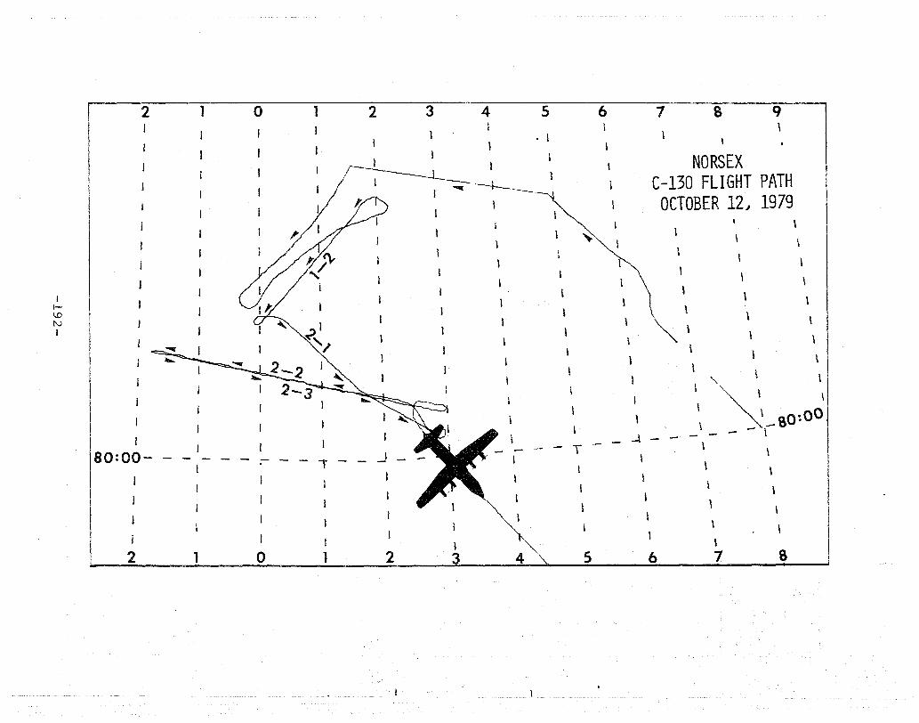
I f-i 1...0 !\.)
I
2
I
80:00-
1 0 1
,.
2 3 4 5 l
. \ 1
I
,~I j---+--.
I ~ ,------~
.J
, I
1 ,
, 1
i
\
~\
\
1
6
1
1
~
T
7 8
NORSEX C-130 FLIGHT PATH
OCTOBER 12" 1979 1
\
\-\ I \
1
\
~\
I
\
....t
\
\
\
1
\
\
\
\
\ \ \ \ \
\
,,\ \
" \ \ "", \ \ ~_80:00 \
\
\
\
- - \
\
\
I I I ) ~ \ 2 1 0 1 2 3 4 ~ 5 6 7 8
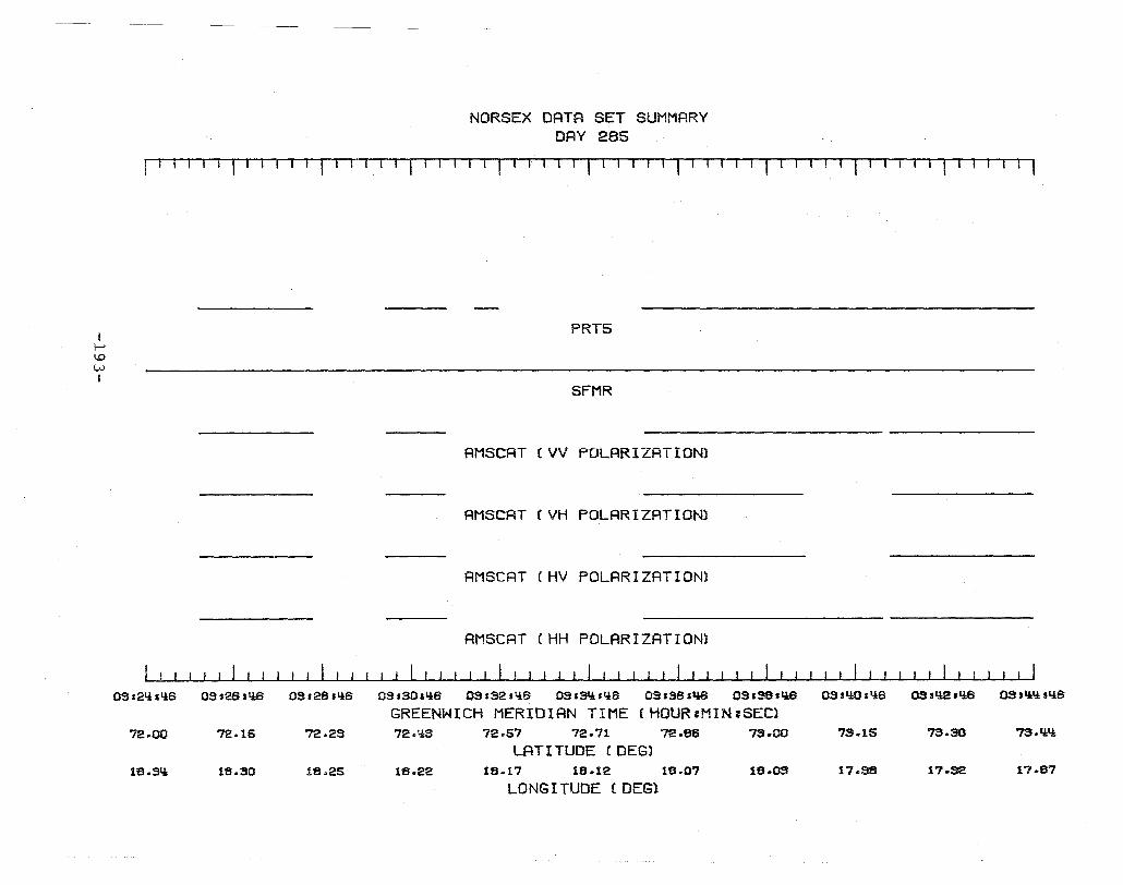
I r-' \.0 W I
OSs21i1I.!B
72.00
15.31i
OS s2S sliB
72.15
18.30
NORSEX DATA SET SUMMARY DAY 285
I T-TT,'l- r 1- I -I T f 1- 1 -I 1 r 1'-1 TT-l,-l T rll1 T ITI -r TIll
PRT5
SFMR
AMSCAT (VV POLARIZATION)
AMSCAT (VH POLARIZATION)
AMSCAT (HV POLARIZATION)
AMSCAT (HH POLARIZATION)
03 s2Bsl.!B OSrSOaliB OS.S2sI.!B OS.3I4:sI.!B 03.SS,qa OS ISS 'liB 03.Y:a,I.!B
GREENWICH MERIDIAN TIME (HOUR:MIN:SEC) 72.23 72.'4:3 72.57 72.71 72.86 7S.OO "13 .. 15
LAT I TUDE (DEG) 15.25 15.22 15.17 18.12 15.0"1 15.03 17.35
LONGITUDE (DEG)
assl4:2.liB QS.q,y:,qB
"73.30 7S.Y:q,
17.32 17.57
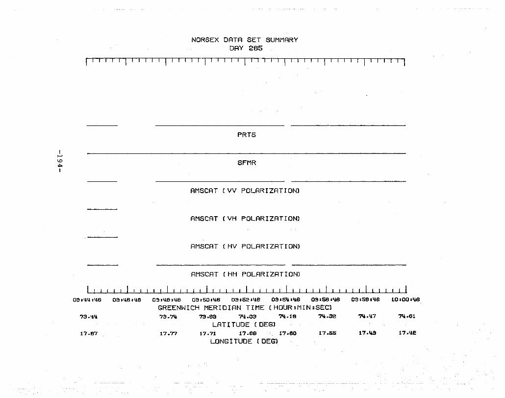
I ~ 1.0 ~
I
NORSEX DATA SET SUMMARY DAY 285
I' -r I . r I -1 I I I I I I I I I I I I 1 I I I I I I -1 I-I
PRT5
SFMR
AMSCAT (VV POLARIZATION)
AMSCAT (VH POLARIZATION)
AMSCAT (HV POLARIZATION)
AMSCAT (HH POLARIZATION)
03.1!1!.I!S 03'I!S'I!S 03 sl!8sl!6 03.SOJ1!6 03.52,qS 03:5'!sQS 03.5S.'iS
GREENWICH MERIDIAN TIME (HOUR:MIN:SEC) 73.1!'! 73.7'* 73.as 7'*.03 7ll.18 7'l.32
LAT I TUDE (DEGl 17.87 17.77 17.71 17.68 17.80 17.55
LONG I TUDE (DEG)
Q3.58.'iS 10s00.'iS
?':l.1!7 7'l.81
17.l1S 17.'12
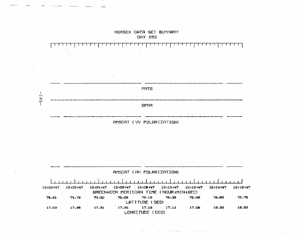
I I--' ~ \...'1 I
NORSEX DATA SET SUMMARY DAY 285
r1fT1 ! 1-1 -1 11 I 1-1 I -111 1'1 III l,rll '{ I I II '1 I I 11 '1 11 -r III
PRT5
SFMR
AMSCAT (VV POLARIZATION)
AMSCAT (HH POLARIZATION)
10sOOs'!7 10s02s'!7 10sOlls'!7 10t06t'!7 10.oes'!7 10s10.'!7 10.12.1i7 10al'!'1i7 10,161ll7
GREENWICH MERIDIAN TIME (HDUR:MIN:SEC) ?Il.61 7ll.76 71i.SO 75.01i 75.15 75.33 75.1ie 76.62 75.76
LATITUDE (DEG) 17.ll3 17.38 17.31 17.25 17.15 17.13 17.06 16.SS 16.53
LONG I TUDE (DEG)
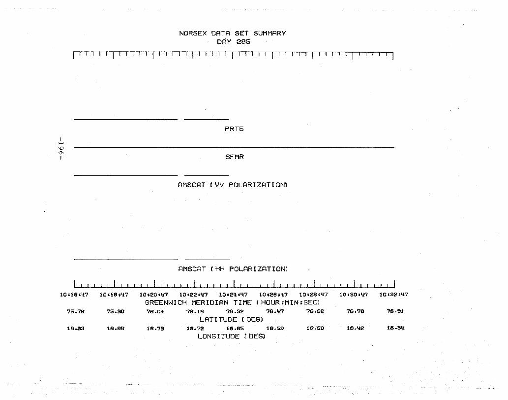
NORSEX DATA SET SUMMARY DAY 285
111TII 1 I J 11 rTll1 I I 1 J 11TIl 1 I 11
I ~
\.0
"" I
10s1fh1i7
75.78
16.33
10.18,'*7
75.SO
16.86
PRT5
SFMR
AMSCAT (VV POLARIZATION)
AMSCAT (HH POLARIZATION)
10,20.,*7 10122.'17 lO.21:l.Ci7 10.28sli7 10.28.li7
GREENWICH MERIDIAN TIME (HOUR:MIN:SEC) 76.0'* 76.18 76.32 76.'17 76.62
LAT I TUDE (DEG) 16.7S 18.72 16.65 16.S8 16.50
LONG I TUDE (DEG)
10s30.li7 10s32I1i7
76.78 76.S1
16.li2 16.SIi
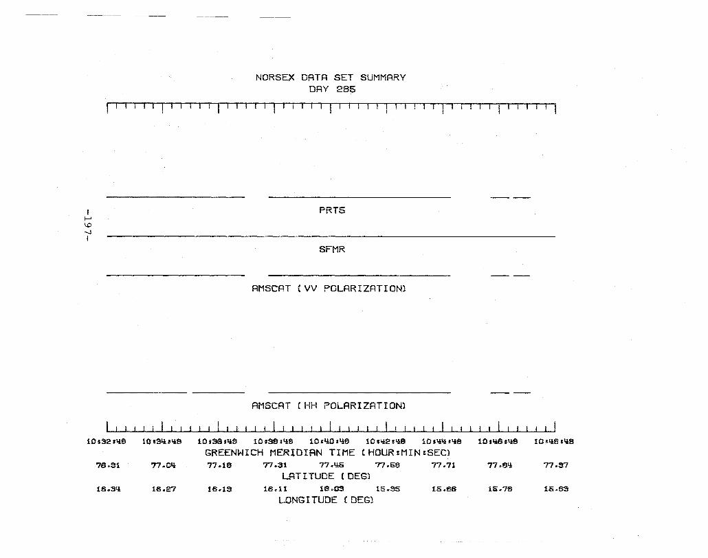
NORSEX DATA SET SUMMARY DAY 285
I I I I I I I I I 11 'l fI T-'--Tl-1 1-1'-'1 11
I I--' \.0 ~ I
10sS2.liS
76.91
16 .. 31:1:
10s$l.Uli8
77.0Y:
16.27
PRT5
SFMR
AMSCAT (VV POLARIZATION)
AMSCAT (HH POLARIZATION)
10.38sliS 10.$,Y:a 10.Y:O.Y:S 10s1.!2sY:8 10sY:Y:sY:a
GREENWICH MERIDIAN TIME (HQUR:MIN:SEC) 77.18 77.31 77.Y:S 77.58 77.71
LAT I TUDE (DEG) 16.1S 16.11 16.03 15 .. 35 lS.as
LONG I TUDE (DEG)
10 sl:lBsy:a 10s11a,Y:a
77.eY: 77.S7
15.78 15.63
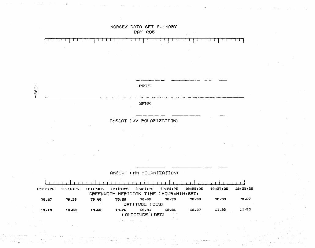
I-' \.D ro I
12.13:25
78.27
1'1.18
12:15.25
?'8.36
13.88
NORSEX DATA SET SUMMARV DAY 285
n 1'1111-1111-1 f r I 1 I I I I r --1 I If if
PRT5
SFMR
AHSCAT (VV POLARIZATION)
AMSCAT (HH POLARIZATION)
12 s 17 s25 12119.25 12.21.25 12,23125 12 125 s25 12127125
GREENWICH MERIDIAN TIME (HOUR:MIN=SECl 78.1l6 78.&6 78.66 78.76 78.86 78.$
LFiT I TUDE (DEG) 13.56 13.25 12.9':1: 12.61 12.27 11.SS
LONG I TUDE (DEG)
12s29.25
7S.07
11 .. 63

NORSEX DATA SET SUMMARY DAY 2~
rl-rrl T1,1-1 TU1l '-I T I I , I I 1-1 '-11 II r J r I J r-Tr-l TI-1 1 I -r I-r -,
I-'
1..0 1..0 I
12.29'25
79.07
11 .. 68
12.91.25
79.17
11 .. 23
PRTS
SFMR
AMSCAT (VV POLARIZATION)
AMSCAT eVH POLARIZATION)
AMSCAT (HV POLARIZATION)
AMSCAT (HH POLARIZATION)
12.99.25 12.35.25 12.37.25 t2.;3S.2S 12s1U s25 12sY:3,2S
GREENWICH MERIDIAN TIME (HOUR:MIN:SEC) 79.27 79.38 79 .. Y:9 79.61 79.72 79.83
LAT I TUDE (DEGl 10.8S 10 .. 'lB 10.03 9.58 S.13 8.87
LONG I TUDE (DEG)
12.'!S.2S
"]s.S5
8 .. 17
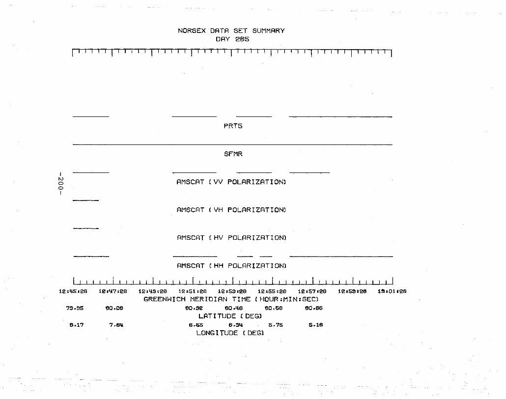
I l\.)
o o I
NORSEX DATA SET SUMMARY DAY 285
fll-r, " I , I I 'I I· I I I I --1 '-1 '-I i ,I -T--r ---r'l
PRT5
SFMR
AMSCAT (VV POLARIZATION)
AMSCAT (VH POLARIZATION)
AMSCAT (HV POLARIZATION)
AMSCAT (HH POLARIZATION)
12,Q5:26 12sQ7s26 12sqsa26 12s51s26 12&53,26 12155:26 12s57.26 12.59128 1$:01'26
GREENWICH MERIDIAN TIME (HOUR:NIN:SEC) 73.35 80.08 80.32 80.Q6 80-56 80.86
LAT I TUDE (DEG) 8.17 7.8'1 6.S5 6.SQ 5.75 5.16
LONG I TUDE (DEG)
NORSEX DATA SET SUMMARY DAY 285
I I Til I I I I I ! I fl I -II '1 I! I I f1l I rUI I l ' IT I -'1 iTI I II
I N o I--' I
1S.15tOLi:
80.86
1.76
lSs17s0Li:
80.76
1.38
coxn::xtIm> 0 ({!mil Ii DO > 00
PHOTOGRAPHY
PRT5
SFMR
AMSCAT (VV POLARIZATION)
AMSCAT (HH POLARIZATION)
lS119s0Li: lSs21=0Y: 13s23 sOli: 13s25.01! 13s27 sOli: 13s29:0Li:
GREENWICH MERIDIAN TIME (HOUR:MIN=SEC) 80.57 80.58 80.51 80.Y:3 80·SO 80.55
LAT I TUDE (DEG) .SS .Li:3 -.01 -.~ .17 .. 5S
LONG I TUDE (DEG)
13sS1s0Y: lS.3$sOL! 13.3S.01!
80.60 8O.5!! 80.66
.36 1.35 1.82
NORSEX DATA SET SUMMARY DAY 285
I I I I I I I 'I I I r 11 I I I I 1 I I I 11 I -IT '-1 I-I I 11 T I I I I I I I I I I , I I I j (
I IV o IV I
lSs35101i
80.66
1.82
13s37'01!
80.70
2.21
(o~0U(888Fi§§KR8Fjijfjf8ii'gi¥'ii"i8ii##i'i8¥iiiiiiiii""i#i8ii'8i'igi iiigii) {li#i8881' ( 00000000000000000000000.1 IIi *,.8 ilI .. 1 IT') CnrrcrJnn.,
PHOTOGRAPHY
1-2 2-1
FLIGHT LINES
PRT5
SFMR
AMSCAT (VV POLARIZATION)
AMSCAT !HH POLARIZATION)
13s33s01! 19,1i1s01,l 1911!3s01i 13sl,lSsOl! lS.l!7s01l 13:I!SaOIi 13:51'OI,l 13:53'011 13'55 sOli
GREENWICH MERIDIAN TIME (HOURIMIN.SEC) 80.72 80·S6 8O.S0 80-61,l 80.118 80 .. 112 80.110 80.110 80.S!!
LAT I TUDE (DEGl 1.8'i 1.SO 1.17 .82 .50 .18 -.10 .35 .72
LONGITUDE (DEG)

NORSEX DATA SET SUMMARY DAY 285
~1--rl~-r-r-'1Ilfll-I-'lI--11 -11-1- 1 II -, 1-1 II Cut:iJt.LtltfiLtfiIfii:j i j ii E j IIA i:lCIJLU:l:j]. 0
I tv o w I
2-1
13:55.06
80.S!!
.72
13a57s05 13:53305
80.28 80.22
1.08 1.14:5
o PHOTOGRAPHY
2-2
FLIGHT LINES
PRT5
SFMR
---- ----AMSCAT (VV POLARIZATION)
AMSCAT (VH POLARIZATION)
AMSCAT (HV POLARIZATION)
--- ---AMSCAT CHH POLARIZATION)
iqsOl,OS 11.!s03sOS lqs05s05 114:I07s05 lqs03.05 114:311105
GREENWICH MERIDIAN TIME (HOUR:MIN:SEC) 80.17 eO.13 ao.os 80.06 eO.l0 80.16
LATITUDE C DES) 1 .. ~ 2.2ti 2.65 2.31 2.82 2.14:2
LONG I TUDE (DEG)
( lII1DlUlI:t:i:O-'
I IH13:Q5 illsI51QS
80.18 80.1S
2.02 1.82
I l\)
o .j::>.
I
NORSEX DATA SET SUMMARY DAY 285
r--.-TII II rill '1 I , I J I I I I I I I I I I r I I I I I I r IT 1T ITTT-'
C UIX:II1I1UlJ.XJLIIJUlL](.JlXAlO ~ r-txXXXD") r CXXD"'1 <XLIX •••• # I X )~ C cxxrrn-., ((DI~C("ljj'k'iiIUlO1IXfiD)
PHOTOGRAPHY
2-2 2-2
FLIGHT LINES
PRT5
SFMR
AMSCAT (VV POLARIZATION)
AMSCAT (VH POLARIZATION)
ANSCAT (HH POLARIZATION)
111,15s05 111s17&05 111113105 111.21105 lY:s23s05 1".25.05 1Y:.27.05 {IH2S.05
GREENWICH MERIDIAN TIME (HOUR:MIN:SEC) eO·lS eO.20 eO.22 eO.21i 80.25 80.28 80.28 80.29
LAT I TUDE (DEG) 1.82 1.18 .78 .SII -.08 -.50 -.91 -1.39
LONGITUDE (DEG)
C(·········XXLkIIAAJ)
2-3
111,31.05 111:39:05 111.95.05
80.S0 80.28
-1.52 -1.05
NORSEX DATA SET SUMMARY DAY 285
1-11 11 11' II I 1 1 I 1 1 1 1 1 1 -. 11 11 TIl II 1 1 1 1 1 1 -Til r-l Tl 1 1-'
~ lfij t dill' Ii Ii i Ii a Wi .RiUL, c.aDID (CD:ID[ ---:::: :iii,c,aiiii"iiii')(iiiiHi"i""SS'SSi •• <tE[),'i'S'i'i'.
I rv o U1 I
2-3
1"1.35'08
80.28
-1.01l
1"1.97:08 1"1aSSs08
80.27 80.25
-.57 -.10
PHOTOGRAPHY
FLIGHT LINES
PRT5
SFMR
AMSCAT (VV POLARIZATION)
AMSCAT CHH POLARIZATION)
1"1sI{1.08 1'l.1{3.08 11{s1{5s08 11{:1{7sQS 11{.I{S.06 1\l.51.0S
GREENWICH MERIDIAN TIME (HDUR:MIN:SEC) 80·23 80.22 80·20 80.18 80.18 80.11{
LAT I TUDE (DEG) .'37 .B3 1 .. 2S 1 .. 75 2.2l! 2.68
LONG I TUDE (DEG)
11l.53s0S 1'1.55'0S
80.15 8O.U~
2.S3 2.61
I N o 0"1 I
NORSEX DATA SET SUMMARY DAY 285
I I 1-1 I I I-I I I I I 1 I I I I 1 1 I I IT-'l-I --lllll
PRT5
SFMR
AMSCAT (VV POLARIZATION)
AMSCAT (HH POLARIZATION)
111,55:08 11is57.08 111153.06 15,01.06 15:03'06 15.05'08 15'07'06 1510S.06
GREENWICH MERIDIAN TIME (HQUR:MINISECl eO.16 7S.57 73.87 75.77 73.67 7S .. 67 7S.'l6
LATITUDE (DEG) 2.61 3.08 S.55 'l.Ol f!.'lS '1.57 5.1lS
LONGI TUDE (DEG)
15,11.06 15.1S.06 15.15108
7S.all 7S.23 75·11
S.55 8.1i6 8.32
NORSEX DATA SET SUMMARY DAY 285
",-T1'-,rTI' T111i-r'111 Tl I 1--1 I II I 1 I I I II I IT 11'1111 1-
I tv o ......,]
I
15.15.07
79.11
B.SS
15.17.07 15.19.07
76.SS 78.8S
7 .. 110 7.87
PRT5
SFMR
AMSCAT (VV POLARIZATION)
AMSCAT (HH POLARIZATION)
15121107 15123.07 15.25,07 15.27'07 1512S.07 15.91.07 15.33.07
GREENWICH MERIDIAN TIME (HOURtMINISEC) '78.7t! 78.62 78.'18 ?B.SS 78.21 78.07 77 .. S3
LAT I TUDE (DEG) 8.33 8.78 9.25 S .. 72 10.18 10.B2 11.08
LONG I TUDE (DEG)
15.35.07
77.79
11.'lS
NORSEX DATA SET SUMMARY DAY 285
r I I I I I I I I I I I I I I I I I I I I I I I ., ' I I I I I I I II '-.1111
I l\.)
o 00 I
15:35107
77.75
B.liS
15a37.07 15aSS'07
77.65 77.61
11.S1 12.S1
PRT5
SFMR
AMSCAT (VV POLAR I ZAT ION)
ANSCRT (HH POLARIZATION)
! I I
I5aliia07 15.IlSaO? 15'1:15'07 15.1:17.07 15:1:IS.07 15.51,07 15.53.07
GREENWICH MERIDIAN TIME (HQUR:MIN:SEC) 77.37 77.23 77.OS 76.S6 76.80 76.63 76.1i6
LATITUDE (DEG) 12.71 13.10 tS.lle 13.85 11:1.12 lli.21 IIi.liO
LONGITUDE (DEG)
15.55107
76.2S
11l.58
NORSEX DATA SET SUMMARY DAY 285
r r I I I I I I I I I I I I I I I I I i I I I I I I II I I r 11-' -,
! N o 1..0 I
15155 sOB
78.28
11l.56
15157s08 15.!iS108
78.12 7S.S5
11l.70 11l.56
PRT5
SFMR
AMSCAT (VV POLARIZATION)
AMSCRT (HH POLARIZATION)
16101.08 18103108 16106108 18107.08 18.0Ss08
GREENWICH MERIDIAN TIME (HOUR:MIN:SEC) 75.73 75.83 75.'iB 75.31 75.17
LAT I TUDE (DEG) 15.00 lS.OS 15.16 15.21l 15.33
LONG I TUDE (DEG)
16111 tOS 18tlS.OS 18t15.09
?'Il.S2 7'!.52
15.68 15.77
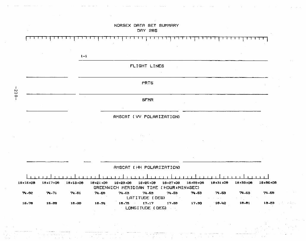
I I\.)
I-' o I
NORSEX DATA SET SUMMARY DAY 285
I I I I I I I I I , I '1 ' , II I , I I II I r-I 1 T
1-1
FLIGHT LINES
PRT5
SFMR
AMSCAT (VV POLARIZATION)
AMSCAT (HH POLARIZATION)
18,15,08 18.17s08 18.1S,08 18821.08 18.23'08 18.25:09 18127.08 16,es.08
GREENWICH MERIDIAN TIME (HOUR:MIN,SEC) 7Il.82 'N.71 71i.61 71i.58 71i.53 71i.53 71i.53 'N.53
LAT I TUDE (DEG) 15.76 15.8S 16 .. 00 16.Sll 16.75 17.17 17.58 17.SS
LONG I TUDE (DEG)
18831108 18.33.08 18.35.08
71i.53 711.63 71i.58
U~.l!O 18.81 1S.23

I tv I-' I-' !
NORSEX DATA SET SUMMARY DAY 285
r T r- I -, r I I I I II r I T ,-, -, II 1 1'1 r I , I 'I J '-I T '1' r II 11-r 1 III r I I J - I -, r1if -",
1-1 2-1 5-1
FLIGHT LINES
PRT5
SFMR
AM SCAT (VV POLARIZATION)
AMseAT (HH POLARIZATION)
18,35,OS 181'S7,OS 18ISS'OS 18s lU .OS 18sq'S.OS 18,qssOS 16.Q7:0S 181~sOS 16.51.09 16.SSs09 16.SS.09
GREENWICH MERIDIAN TIME (HQUR:MIN'SEC) 711.sa 71!.S8 7,!.Qa ?1!.37 71:l.27 7'i.28 71!.28 7'i.S2 7Il.32 7I!.30 71l.30
LAT I TUDE (DEG) 1S.23 1S.65 15.69 15·67 1$.73 19.72 13.69 1S.83 13.51 13.08 18.SQ
LONG I TUDE (DES)
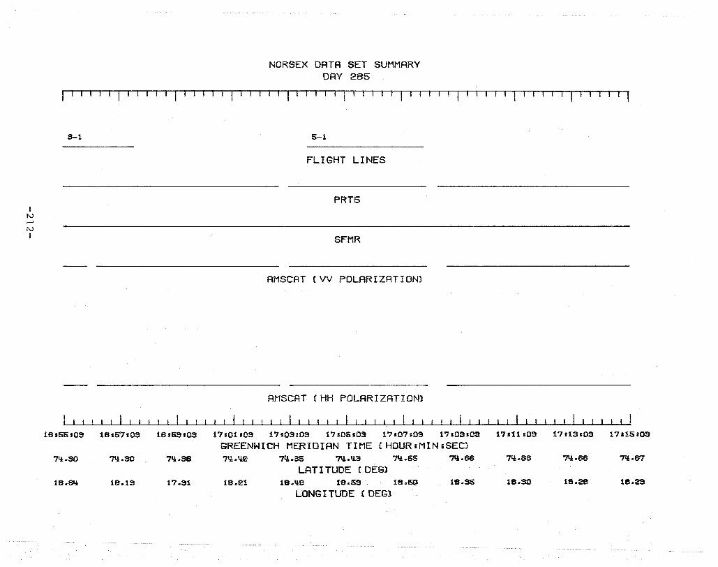
I tv t-' tv I
NORSEX DATA SET SUMMARY DAY 285
r I 1 T1 [-1. 1 I I r f1 I I I I I I I I I I I I' J I I rrT-r-1l
3-1 5-1
FLIGHT LINES
PRT5
SFMR
AMSCAT (VV POLARIZATION)
AMSCAT (HH POLARIZATION)
16 155 lOS 18157103 16.SSI03 17101 lOS 17s03.09 17:0SIOS 17s07:0S 17100.03 GREENWICH MERIDIAN TIME (HDUR:MIN;SEC)
71!.SO 7Q.30 71i.38 71i.1!2 7".35 7I!.1!3 7I! .. 55 ?'l.sa LATITUDE (DEG)
U~.SIi IB.1S 17.S1 IB.21 lS.IiB lB.SS IB.SO US.S5
LONGITUDE (DEG)
17.11 s09 17113109 17a15.QS
7Q.SS ?Ii.sa 71! .. fn
18.30 1B.28 IB.2S

I tv t-' W I
NORSEX DATA SET SUMMARY DAY 285
I I I I I I I I I I I ! I I I I I I I I I I I I I I I f l T l 'lr -, -1-1-rr r TTl -1,1
6-1 7-1
FLIGHT LINES
PRT5
SFMR
AMSCAT (VV POLARIZATION)
AMSCAT (HH POLARIZATION)
17115.10 1711"1110 17119.10 17s21110 17123.10 17.251110 1712"1110 17s29110
GREENWICH MERIDIAN TIME (HDUR:MIN:SEC) 7':1:.67 71i.58 ?Ii.58 71:1:.56 71.!.56 71.!.56 ?Ii.56 7l.ie55
LATITUDE (DEG) 18.29 18.33 18.78 19.21 19.59 20.01 20.'!1.! 20.76
LONG I TUDE (DEG)
17131.10 171$3810 17.$6.10
71.!.1.!1.! 7I.!.sq 7Il.23
20.&! 2O.1jO eo.Sf!

I I\.)
t-' ~ I
NORSEX DATA SET SUMMARY DAY 285
r , .. , 1'1 I' r I 1ill-I'·'TTTTTI
7-1 8-1
FLIGHT LINES
PRTS
SFMR
AMSCAT (VV POLARIZATION)
AMSCAT (HH POLARIZATION)
17.35110 17'3"1'10 17.SS.10 17_'U .10 1711QSdO 17.QSsl0 17.'17_10 171QSsl0 GREENWICH MERIDIAN TIME (HOUR:MIN:SEC)
?'!l.2S "N.12 ?'!l .. O1 73.96 7Q.07 71l.17 7Il.2S 7'1.1l2 LAT I TUDE (DEG)
2O.3IA 2O.S1 eo.so 2D.'W 20.25 20.OS IS.S5 IS.88 LONG I TUDE (DEG)
17161110 17.53.10 17.66r10
"N.IIS '7'l.60 "N.IIS
1S.88 1S.88 1S.Btl
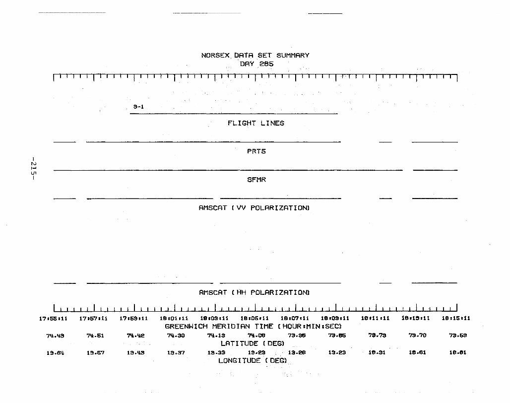
I N I-' U1 I
NORSEX DATA SET SUMMARY DAY 285
I I I I I I I I I I I I I I I I I I 1 I I I I I I I I I I I I' I I , 11 I 1 I I I I r-r· 1 I I I'-rll- I
S-1
FLIGHT LINES
PRT5
SFMR
AMSCAT (VV POLARIZATION)
AMSCAT (HH POLARIZATION)
17.55111 17.5"1.11 1'1.SS.11 19.01.11 18.03.11 19105.11 lSIO?'.11 18.OS111 18.11.11 18'1~hl1
GREENWICH MERIDIAN TIME (HOURIMIN:SEC) 7':l.l!S 7l!.61 7ll.l!2 7'l.SO 7ll.1S 7'i.08 73.86 73.86 73.'1S 73.70
LATITUDE (DEG) 1S.S'! 1S.57 IS.l!3 1S.37 13.33 1S.23 13.26 1S.23 18.S1 18.61
LONG I TUDE (DES)
lSIISlt1
73.63
18.61
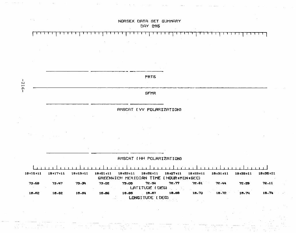
I N i-'
0'\ I
NORSEX DATA SET SUMMARY DAY 285
lIT IT T-r TIl 'l-r,-T-rT 1 ff -1 . ,- II 1 '-1 "--T
PRT5
SFMR
AMSCAT (VV POLARIZATION)
AMSCAT (HH POLARIZATION)
ifH1S;U 18U7.11 18.19.11 18.21111 Uh23 111 18125.11 1812'1.11 18129111
GREENWICH MERIDIAN TIME (HOURIMINISEC) 73.58 73.117 7S.3Il 73.22 ?S.es 72.S'! 72.71 72.61
LAT I TUDE (DEG) US.52 18.82 18.6Il 18.86 18.68 18.en 18.68 18.70
LONGITUDE ( DEG)
181S1111 18193.11 18.SSII1
72.'l1l 72.28 72.11
18.72 18.7Il 18.7Il

I 2. Government Accession No. 1. Report No.
NASA CR-165967 4. Title and Subtitle NORSEX 79 Microwave Remote Sensing Data SUITIDary Report September 29 - October 12, 1979
7. Author(s)
3. Recipient's Catalog No.
5. Report Date May 1982
6. Performing Organization Code
8. Performing Organization Report No.
Harold F. Hennigar Sally K. Schaffner
t-------------------------------~ 10. Work Unit No. 9. Performing Organization Name and Address
The Bionetics Corporation 18 Research Drive Hampton, Virginia 23666
12. Sponsoring Agency Name and Address
National Aeronautics & Space Administration Washington, D. C. 20546
15. Supplementary Notes
11. Contract or Grant No.
NASl-l6978
Contractor Report 14. Sponsoring Agency Code
Langley Technical Monitor: William L. Grantham
16. Abstract
A summary is given of the airborne microwave remote sensing measurements obtained by NASA Langley Research Center in support of the 1979 Norwegian Remote Sensing Experiment (NORSEX). The remote sensing objectives of NORSEX were to investigate the capabilities of an active/ passive microwave system to measure ice concentration and type in the vicinity of the marginal ice zone near Svalbard, Norway and to apply microwave techniques to the investigation of a thermal oceanic front near Bear Island, Norway. The instruments used during NORSEX include the Stepped Frequency Microwave Radiometer (SFMR) I Airborne Microwave Scatterometer (AMSCAT), Precision Radiation Thermometer (PRT-5) and metric aerial photography. Remote sensing data are inventoried, summarized and presented in a user-friendly format. Data summaries are presented as time-history plots which indicate when and where data were obtained as well as the sensor configuration. All data are available on nine-track computer tapes in card-image format upon request to the NASA Langley Technical Library.
17. Key Words (Suggested by Author(s))
Remote Sensing Microwaves
19. Security Classif. (of this report)
Unclassified
18. Distribution Statement
Unclassified - Unlimited
20. Security Classif. (of this page)
Unclassified
Subject Category 43
21. No. of Pages 22. Price
222 A10
N-305 For sale by the National Technical Information Service, Springfield, Virginia 22161

End of Document