Embed Size (px)
Citation preview
*S8337611*©
NationalQualicationsSPECIMEN ONLY H
Total marks — 100
SECTION 1 — PHYSICAL ENVIRONMENTS — 50 marks
Attempt ALL questions.
SECTION 2 — HUMAN ENVIRONMENTS — 50 marks
Attempt ALL questions.
You will receive credit for appropriately labelled sketch maps and diagrams.
Write your answers clearly in the answer booklet provided. In the answer booklet you must clearly identify the question number you are attempting.
Use blue or black ink.
Before leaving the examination room you must give your answer booklet to the Invigilator; if you do not, you may lose all the marks for this paper.
S833/76/11 GeographyPhysical and Human
EnvironmentsDate — Not applicable
Duration — 1 hour 50 minutes
page 02
MARKSSection 1— PHYSICAL ENVIRONMENTS — 50 marks
Attempt ALL questions.
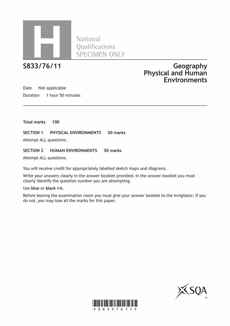
Question 1
Diagram Q1: A meander on the River Clyde
Look at Diagram Q1.
Meanders are features commonly found in the middle and lower course of rivers.
Explain the formation of a meander.
You may wish to use an annotated diagram or diagrams. 8
page 03
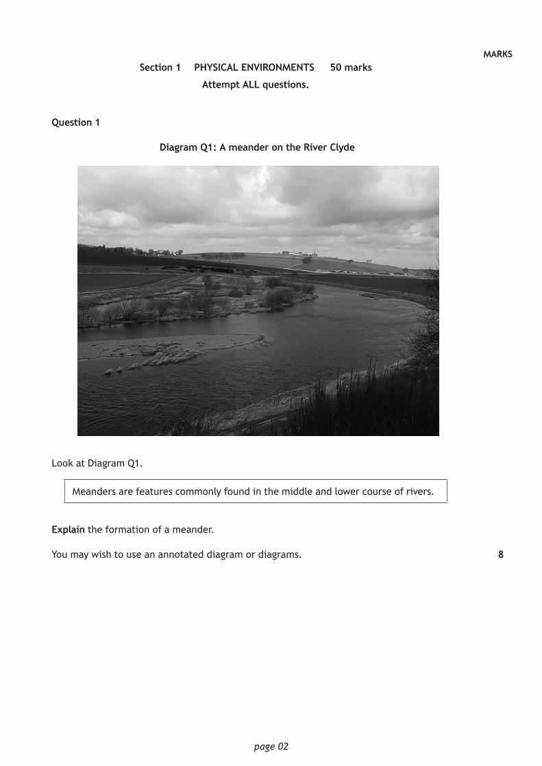
MARKSQuestion 2
Diagram Q2: Flood hydrograph for the River Valency at Boscastle, 16 August 2004
06:0
007
:00
08:0
009
:00
10:0
011
:00
12:0
013
:00
14:0
015
:00
16:0
017
:00
18:0
019
:00
20:0
021
:00
22:0
0
120
100
80
60
40
20
0
1614121086420
Time
Rainfall
Discharge
Rain
fall
(mm
)
Dis
char
ge (
cum
ecs)
Study Diagram Q2.
For the River Valency at Boscastle on 16 August 2004:
(a) describe the changes in discharge level and
(b) suggest reasons why these changes may have occurred. 10
page 04
MARKSQuestion 3
Draw a fully annotated soil profile of a podzol soil to show its main characteristics (including horizons, colour, texture and drainage), and associated vegetation.
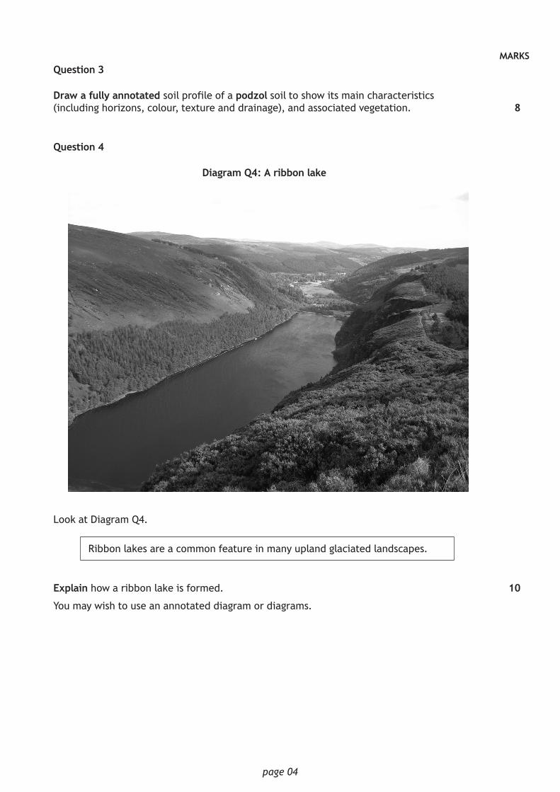
Question 4
Diagram Q4: A ribbon lake
Look at Diagram Q4.
Ribbon lakes are a common feature in many upland glaciated landscapes.
Explain how a ribbon lake is formed.
You may wish to use an annotated diagram or diagrams.
8
10
page 05
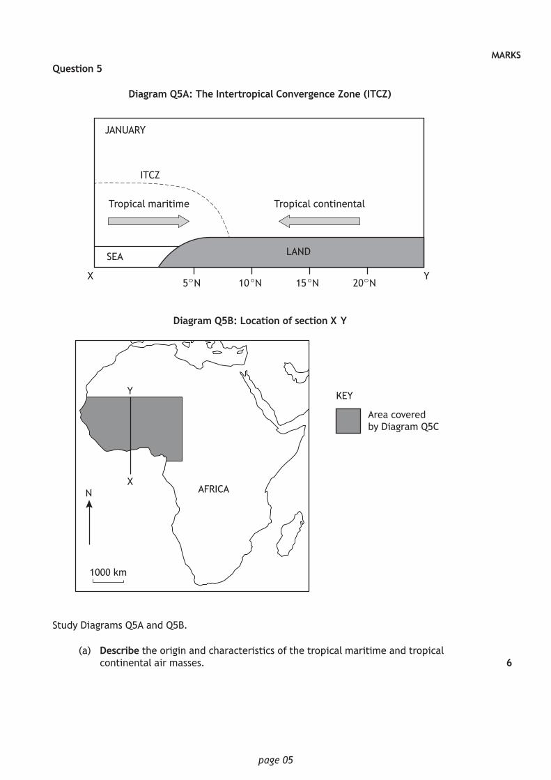
MARKSQuestion 5
Diagram Q5A: The Intertropical Convergence Zone (ITCZ)
JANUARY
ITCZ
Tropical maritime Tropical continental
SEA LAND
X Y5 N 10 N 15 N 20 N
Diagram Q5B: Location of section X–Y
1000 km
N
Y
XAFRICA
Area covered by Diagram Q5C
KEY
Study Diagrams Q5A and Q5B.
(a) Describe the origin and characteristics of the tropical maritime and tropical continental air masses. 6
page 06
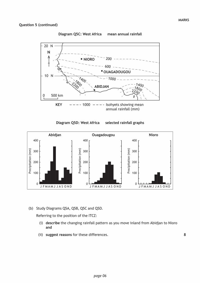
MARKSQuestion 5 (continued)
Diagram Q5C: West Africa — mean annual rainfall
•
•
•
20° N
10° N
N
500 km
KEY 1000 Isohyets showing meanannual rainfall (mm)
NIORO
OUAGADOUGOU
ABIDJAN140018002200
140018002200
200
600
1000
0
Diagram Q5D: West Africa — selected rainfall graphs
0
100
200
300
400
Ouagadougou
0
100
200
300
400
Nioro
J F M A M J J A S O N DJ F M A M J J A S O N D0
100
200
300
400
Abidjan
Prec
ipit
atio
n (m
m)
J F M A M J J A S O N D
Prec
ipit
atio
n (m
m)
Prec
ipit
atio
n (m
m)
(b) Study Diagrams Q5A, Q5B, Q5C and Q5D.
Referring to the position of the ITCZ:
(i) describe the changing rainfall pattern as you move inland from Abidjan to Nioro and
(ii) suggest reasons for these differences. 8
page 07
MARKSSection 2 — HUMAN ENVIRONMENTS — 50 marks
Attempt ALL questions.
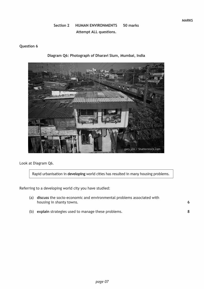
Question 6
Diagram Q6: Photograph of Dharavi Slum, Mumbai, India
Look at Diagram Q6.
Rapid urbanisation in developing world cities has resulted in many housing problems.
Referring to a developing world city you have studied:
(a) discuss the socio-economic and environmental problems associated with housing in shanty towns.
(b) explain strategies used to manage these problems.
6
8
page 08
MARKSQuestion 7
Many glaciated and coastal areas have competing land users which can create conflict.
Referring to a glaciated upland or coastal area you have studied:
(a) explain the strategies used to manage these conflicts and
(b) comment on the effectiveness of these strategies.
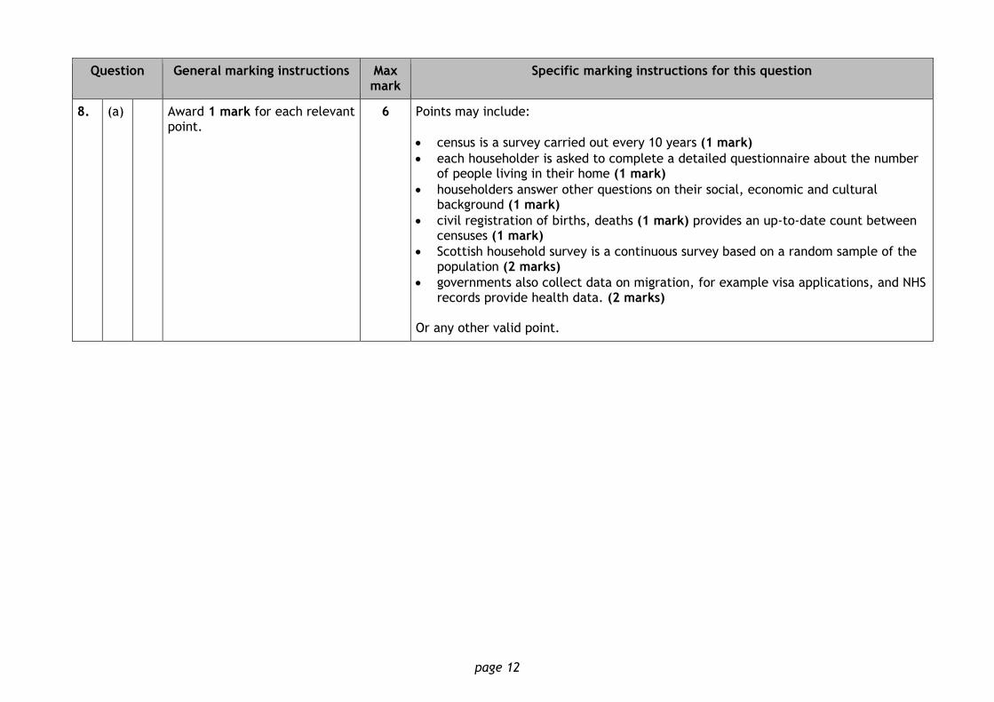
Question 8
In November 2013, the chairperson of Nigeria’s National Population Commission resigned after questioning the accuracy of the data gathered about the country’s population.
(a) Discuss how countries gather accurate population data.
(b) Referring to countries you have studied, explain why it is difficult to gather accurate population data in developing world countries.
10
6
12
page 09
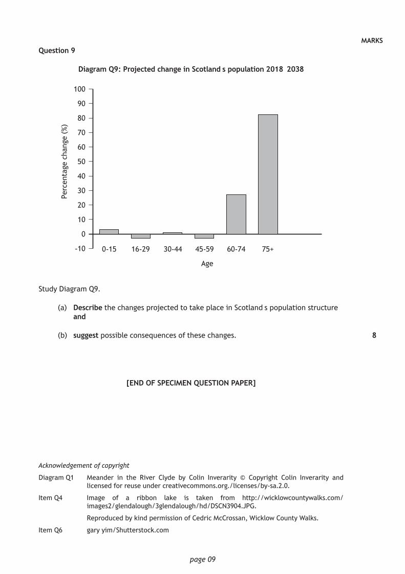
MARKSQuestion 9
Diagram Q9: Projected change in Scotland’s population 2018–2038
100
90
80
70
60
50
40
30
20
10
0
-10 0-15 16-29 30-44 45-59 60-74 75+
Perc
enta
ge c
hang
e (%
)
Age
Study Diagram Q9.
(a) Describe the changes projected to take place in Scotland’s population structure and
(b) suggest possible consequences of these changes.
[END OF SPECIMEN QUESTION PAPER]
8
Acknowledgement of copyright
Diagram Q1 Meander in the River Clyde by Colin Inverarity © Copyright Colin Inverarity and licensed for reuse under creativecommons.org./licenses/by-sa.2.0.
Item Q4 Image of a ribbon lake is taken from http://wicklowcountywalks.com/ images2/glendalough/3glendalough/hd/DSCN3904.JPG.
Reproduced by kind permission of Cedric McCrossan, Wicklow County Walks.
Item Q6 gary yim/Shutterstock.com
S833/76/11 GeographyPhysical and Human
Environments
Marking Instructions
The information in this publication may be reproduced to support SQA qualifications only on a non-commercial basis. If it is reproduced, SQA should be clearly acknowledged as the source. If it is to be used for any other purpose, written permission must be obtained from [email protected].
Where the publication includes materials from sources other than SQA (ie secondary copyright), this material should only be reproduced for the purposes of examination or assessment. If it needs to be reproduced for any other purpose it is the user’s responsibility to obtain the necessary copyright clearance.
These marking instructions have been provided to show how SQA would mark this specimen question paper.
©
NationalQualicationsSPECIMEN ONLY H
page 02
General marking principles for Higher Geography
Always apply these general principles. Use them in conjunction with the detailed marking
instructions, which identify the key features required in candidates’ responses.
(a) Always use positive marking. This means candidates accumulate marks for the
demonstration of relevant skills, knowledge and understanding; marks are not deducted for errors or omissions.
(b) If a candidate response does not seem to be covered by either the principles or detailed marking instructions, and you are uncertain how to assess it, you must seek guidance from your team leader.
(c) Where the candidate does not comply with the rubric of the paper and answers two parts in one section, mark both responses and record the better mark.
(d) Marking must be consistent. Never make a hasty judgement on a response based on length, quality of handwriting or a confused start.
(e) Use the full range of marks available for each question.
(f) The detailed marking instructions are not an exhaustive list. Award marks for other relevant points.
(g) Award marks only where points relate to the question asked. Where candidates give points of knowledge without specifying the context, award marks unless it is clear that they do not refer to the context of the question.
(h) Award marks for knowledge/understanding where points are:
relevant to the issue in the question
developed (by providing additional detail, exemplification, reasons or evidence)
used to respond to the demands of the question (for example evaluate, analyse). Marking principles for each question type There is a range of question types in this question paper. For each question type, the following provides an overview of marking principles, and an example.
Describe questions Candidates gain marks for making relevant, factual points. These should be key points. The points do not need to be in any particular order. Candidates may provide a number of straightforward points or a smaller number of developed points, or a combination of these. Candidates must provide more than an outline or list to gain marks. They could refer to, for example, a landscape feature, a landscape formation process, a situation or facts demonstrating geographical knowledge. Explain questions Candidates gain marks for explaining or suggesting reasons for the cause or impact of something, or for referring to causal connections and relationships. Candidates must do more than describe to gain marks here.
Where the question asks about a landscape feature, candidates should refer to the processes leading to landscape formation.
For a source-based question, candidates should make use of these and refer to them within their answer for full marks.
page 03
Where candidates provide a purely descriptive answer, or one where development is limited, award no more than half the available marks for the question. Other questions look for candidates to demonstrate higher-order skills and will use command words such as analyse, evaluate, to what extent, and discuss. Analyse questions Candidates gain marks for identifying parts, the relationship between them, and their relationships with the whole; and for drawing out and relating implications. Award an analysis mark where candidates use their knowledge and understanding or a source to identify relevant components (for example of an idea, theory, argument) and clearly show at least one of the following:
links between different components
links between component(s) and the whole
links between component(s) and related concepts
similarities and contradictions
consistency and inconsistency
different views or interpretations
possible consequences or implications
the relative importance of components
understanding of underlying order or structure. Where candidates are asked to analyse they should identify parts of a topic or issue and refer to the interrelationships between, or impacts of, various factors. For example, where a question asks for an analysis of the soil-forming properties which lead to the formation of a gley soil, candidates should refer to how the various soil formatting properties contributed to its formation. Evaluate questions Candidates gain marks for making a judgement of the success, failure, or impact of something based on criteria. They should give a brief description of the strategy or project being evaluated, before offering an evidenced conclusion. Account for questions Candidates gain marks for giving reasons which are often (but not exclusively) from a resource, for example: for a change in trade figures; a need for water management; or differences in development between contrasting developing countries. Discuss questions Candidates gain marks for exploring ideas about a project, or the impact of a change. They should consider different views on an issue or argument. This might not be a balanced argument, but they should give a range of impacts or ideas within their answer. To what extent questions Candidates gain marks for considering the impact of a management strategy or strategies they have explored. They should give a brief description of the strategy or project being evaluated, before offering an evidenced conclusion. They do not need to offer an overall opinion based on a variety of strategies, but should assess each separately.
page 04
Marking instructions for each question Section 1 — Physical environments
Question General marking instructions Max mark
Specific marking instructions for this question
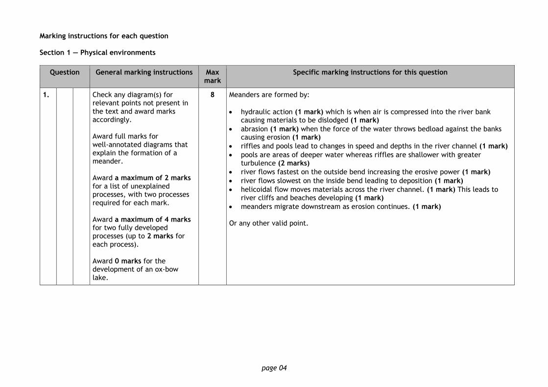
1. Check any diagram(s) for relevant points not present in the text and award marks accordingly. Award full marks for well-annotated diagrams that explain the formation of a meander. Award a maximum of 2 marks for a list of unexplained processes, with two processes required for each mark. Award a maximum of 4 marks for two fully developed processes (up to 2 marks for each process). Award 0 marks for the development of an ox-bow lake.
8 Meanders are formed by:
hydraulic action (1 mark) which is when air is compressed into the river bank causing materials to be dislodged (1 mark)
abrasion (1 mark) when the force of the water throws bedload against the banks causing erosion (1 mark)
riffles and pools lead to changes in speed and depths in the river channel (1 mark)
pools are areas of deeper water whereas riffles are shallower with greater turbulence (2 marks)
river flows fastest on the outside bend increasing the erosive power (1 mark)
river flows slowest on the inside bend leading to deposition (1 mark)
helicoidal flow moves materials across the river channel. (1 mark) This leads to river cliffs and beaches developing (1 mark)
meanders migrate downstream as erosion continues. (1 mark) Or any other valid point.
page 05
Question General marking instructions Max mark
Specific marking instructions for this question
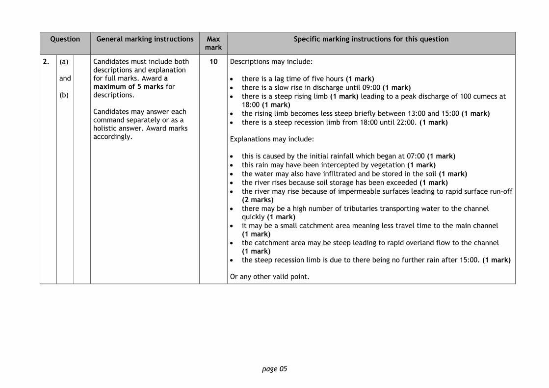
2. (a) and (b)
Candidates must include both descriptions and explanation for full marks. Award a maximum of 5 marks for descriptions. Candidates may answer each command separately or as a holistic answer. Award marks accordingly.
10 Descriptions may include:
there is a lag time of five hours (1 mark)
there is a slow rise in discharge until 09:00 (1 mark)
there is a steep rising limb (1 mark) leading to a peak discharge of 100 cumecs at 18:00 (1 mark)
the rising limb becomes less steep briefly between 13:00 and 15:00 (1 mark)
there is a steep recession limb from 18:00 until 22:00. (1 mark) Explanations may include:
this is caused by the initial rainfall which began at 07:00 (1 mark)
this rain may have been intercepted by vegetation (1 mark)
the water may also have infiltrated and be stored in the soil (1 mark)
the river rises because soil storage has been exceeded (1 mark)
the river may rise because of impermeable surfaces leading to rapid surface run-off (2 marks)
there may be a high number of tributaries transporting water to the channel quickly (1 mark)
it may be a small catchment area meaning less travel time to the main channel (1 mark)
the catchment area may be steep leading to rapid overland flow to the channel (1 mark)
the steep recession limb is due to there being no further rain after 15:00. (1 mark) Or any other valid point.
page 06
Question General marking instructions Max mark
Specific marking instructions for this question
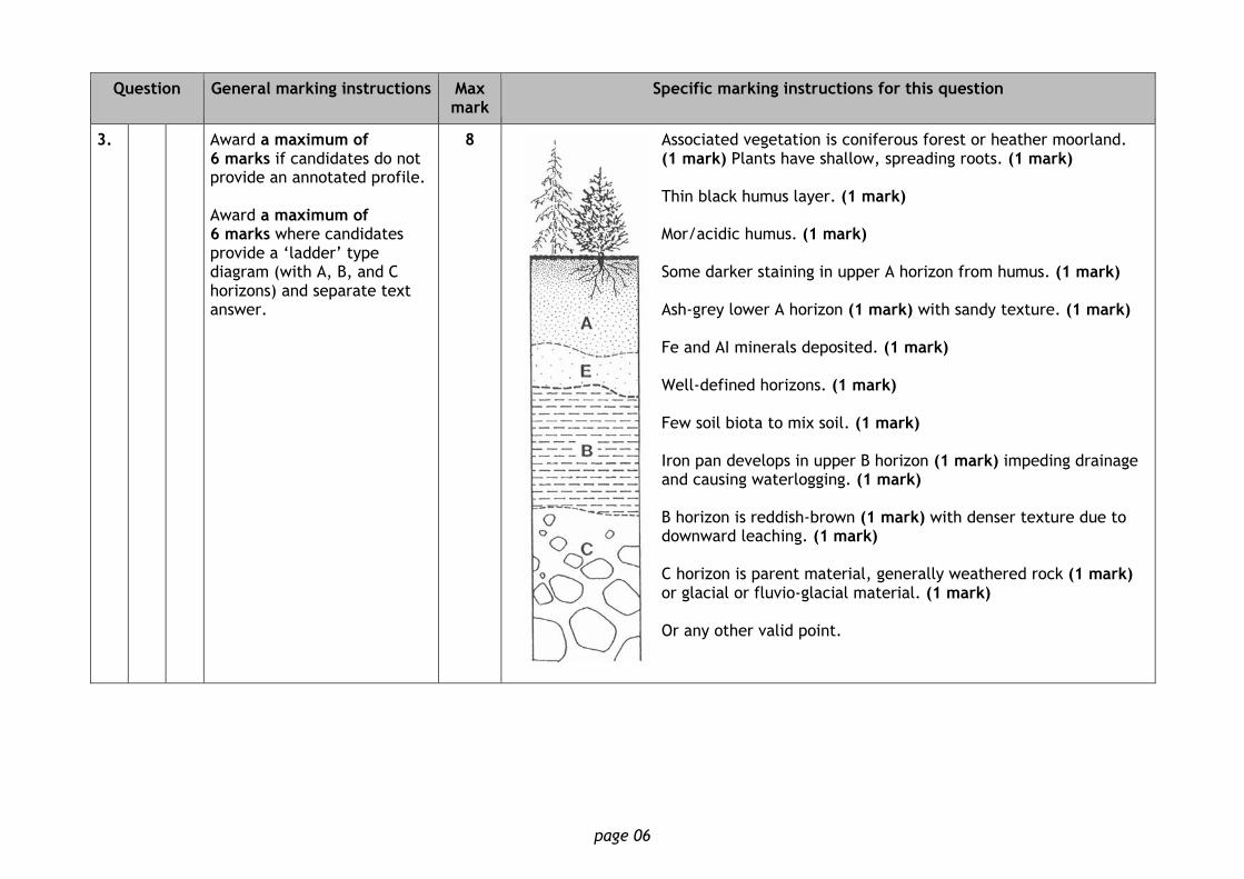
3. Award a maximum of 6 marks if candidates do not provide an annotated profile. Award a maximum of 6 marks where candidates provide a ‘ladder’ type diagram (with A, B, and C horizons) and separate text answer.
8 Associated vegetation is coniferous forest or heather moorland. (1 mark) Plants have shallow, spreading roots. (1 mark) Thin black humus layer. (1 mark) Mor/acidic humus. (1 mark) Some darker staining in upper A horizon from humus. (1 mark) Ash-grey lower A horizon (1 mark) with sandy texture. (1 mark) Fe and AI minerals deposited. (1 mark) Well-defined horizons. (1 mark) Few soil biota to mix soil. (1 mark) Iron pan develops in upper B horizon (1 mark) impeding drainage and causing waterlogging. (1 mark) B horizon is reddish-brown (1 mark) with denser texture due to downward leaching. (1 mark) C horizon is parent material, generally weathered rock (1 mark) or glacial or fluvio-glacial material. (1 mark) Or any other valid point.
page 07
Question General marking instructions Max mark
Specific marking instructions for this question
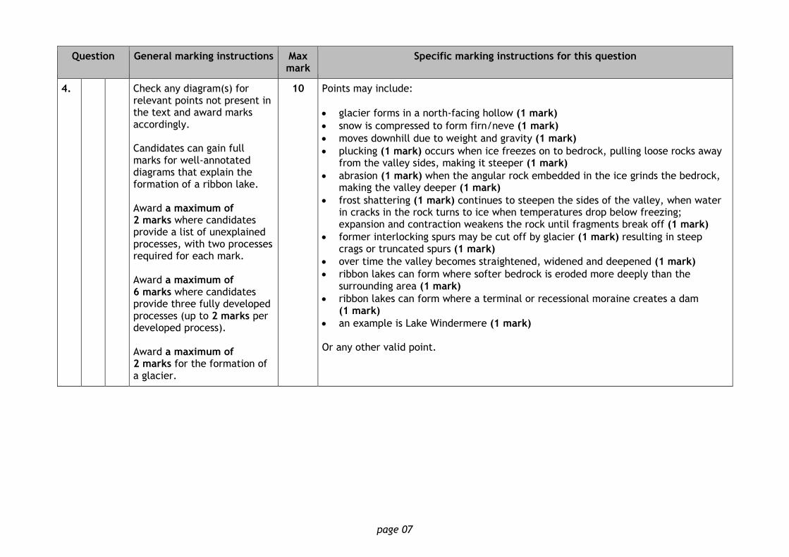
4. Check any diagram(s) for relevant points not present in the text and award marks accordingly. Candidates can gain full marks for well-annotated diagrams that explain the formation of a ribbon lake. Award a maximum of 2 marks where candidates provide a list of unexplained processes, with two processes required for each mark. Award a maximum of 6 marks where candidates provide three fully developed processes (up to 2 marks per developed process). Award a maximum of 2 marks for the formation of a glacier.
10 Points may include:
glacier forms in a north-facing hollow (1 mark)
snow is compressed to form firn/neve (1 mark)
moves downhill due to weight and gravity (1 mark)
plucking (1 mark) occurs when ice freezes on to bedrock, pulling loose rocks away from the valley sides, making it steeper (1 mark)
abrasion (1 mark) when the angular rock embedded in the ice grinds the bedrock, making the valley deeper (1 mark)
frost shattering (1 mark) continues to steepen the sides of the valley, when water in cracks in the rock turns to ice when temperatures drop below freezing; expansion and contraction weakens the rock until fragments break off (1 mark)
former interlocking spurs may be cut off by glacier (1 mark) resulting in steep crags or truncated spurs (1 mark)
over time the valley becomes straightened, widened and deepened (1 mark)
ribbon lakes can form where softer bedrock is eroded more deeply than the surrounding area (1 mark)
ribbon lakes can form where a terminal or recessional moraine creates a dam (1 mark)
an example is Lake Windermere (1 mark) Or any other valid point.
page 08
Question General marking instructions Max mark
Specific marking instructions for this question
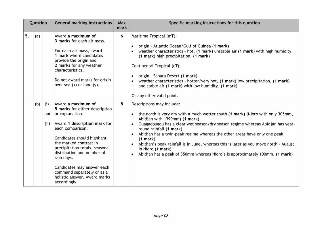
5. (a) Award a maximum of 3 marks for each air mass. For each air mass, award 1 mark where candidates provide the origin and 2 marks for any weather characteristics. Do not award marks for origin over sea (x) or land (y).
6 Maritime Tropical (mT):
origin - Atlantic Ocean/Gulf of Guinea (1 mark)
weather characteristics – hot, (1 mark) unstable air (1 mark) with high humidity, (1 mark) high precipitation. (1 mark)
Continental Tropical (cT):
origin - Sahara Desert (1 mark)
weather characteristics - hotter/very hot, (1 mark) low precipitation, (1 mark) and stable air (1 mark) with low humidity. (1 mark)
Or any other valid point.
(b) (i) and (ii)
Award a maximum of 5 marks for either description or explanation. Award 1 description mark for each comparison. Candidates should highlight the marked contrast in precipitation totals, seasonal distribution and number of rain days. Candidates may answer each command separately or as a holistic answer. Award marks accordingly.
8 Descriptions may include:
the north is very dry with a much wetter south (1 mark) (Nioro with only 305mm, Abidjan with 1390mm) (1 mark)
Ouagadougou has a clear wet season/dry season regime whereas Abidjan has year-round rainfall (1 mark)
Abidjan has a twin-peak regime whereas the other areas have only one peak (1 mark)
Abidjan’s peak rainfall is in June, whereas this is later as you move north - August in Nioro (1 mark)
Abidjan has a peak of 350mm whereas Nioro’s is approximately 100mm. (1 mark)
page 09
Question General marking instructions Max mark
Specific marking instructions for this question
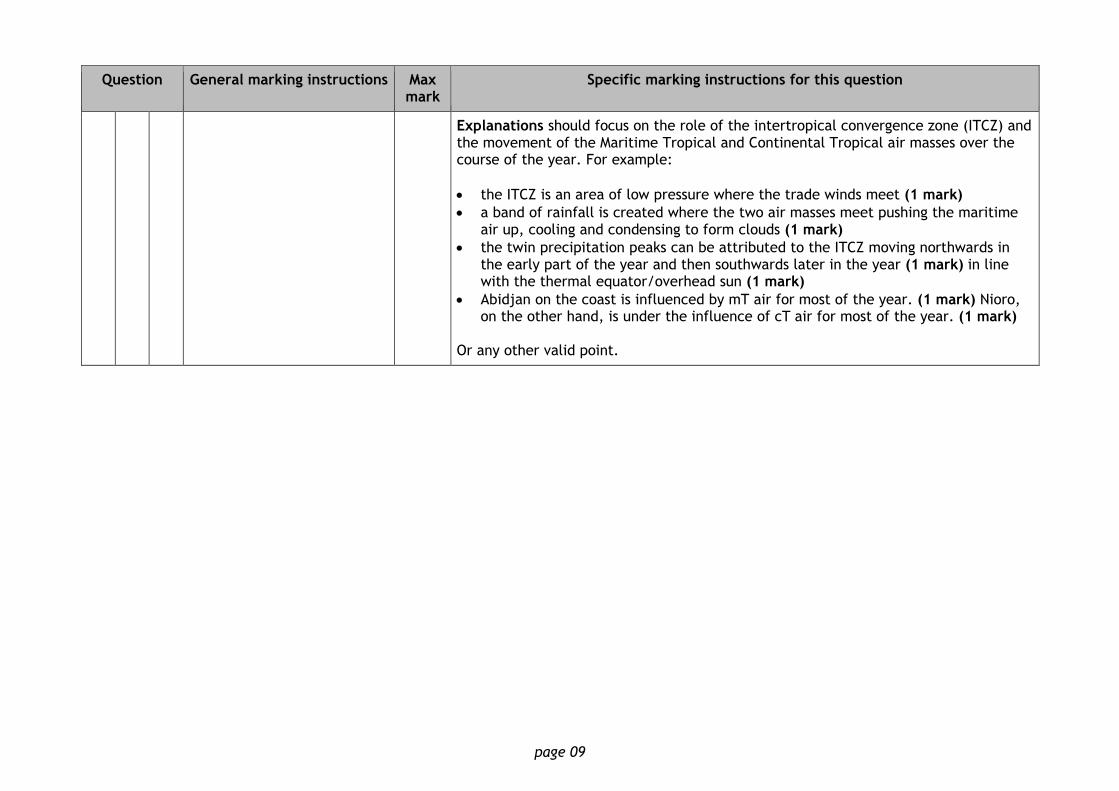
Explanations should focus on the role of the intertropical convergence zone (ITCZ) and the movement of the Maritime Tropical and Continental Tropical air masses over the course of the year. For example:
the ITCZ is an area of low pressure where the trade winds meet (1 mark)
a band of rainfall is created where the two air masses meet pushing the maritime air up, cooling and condensing to form clouds (1 mark)
the twin precipitation peaks can be attributed to the ITCZ moving northwards in the early part of the year and then southwards later in the year (1 mark) in line with the thermal equator/overhead sun (1 mark)
Abidjan on the coast is influenced by mT air for most of the year. (1 mark) Nioro, on the other hand, is under the influence of cT air for most of the year. (1 mark)
Or any other valid point.
page 10
Section 2 — Human environments
Question General marking instructions Max mark
Specific marking instructions for this question
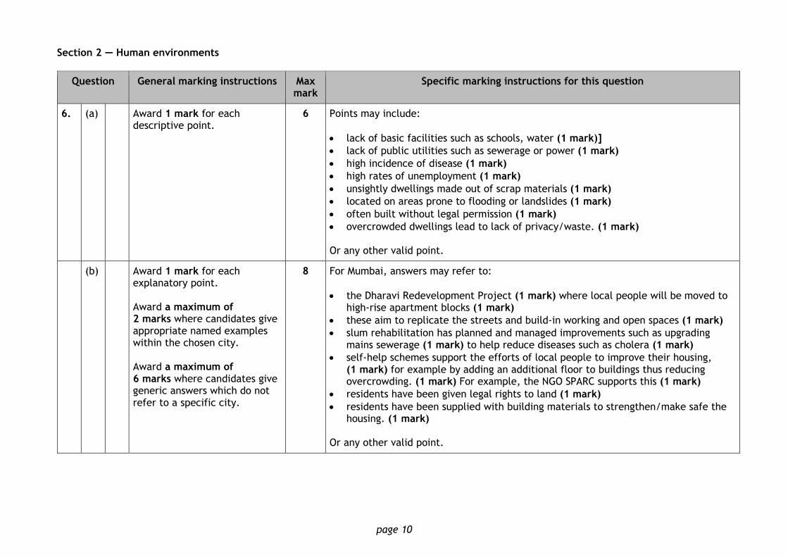
6. (a) Award 1 mark for each descriptive point.
6 Points may include:
lack of basic facilities such as schools, water (1 mark)]
lack of public utilities such as sewerage or power (1 mark)
high incidence of disease (1 mark)
high rates of unemployment (1 mark)
unsightly dwellings made out of scrap materials (1 mark)
located on areas prone to flooding or landslides (1 mark)
often built without legal permission (1 mark)
overcrowded dwellings lead to lack of privacy/waste. (1 mark) Or any other valid point.
(b) Award 1 mark for each explanatory point. Award a maximum of 2 marks where candidates give appropriate named examples within the chosen city. Award a maximum of 6 marks where candidates give generic answers which do not refer to a specific city.
8 For Mumbai, answers may refer to:
the Dharavi Redevelopment Project (1 mark) where local people will be moved to high-rise apartment blocks (1 mark)
these aim to replicate the streets and build-in working and open spaces (1 mark)
slum rehabilitation has planned and managed improvements such as upgrading mains sewerage (1 mark) to help reduce diseases such as cholera (1 mark)
self-help schemes support the efforts of local people to improve their housing, (1 mark) for example by adding an additional floor to buildings thus reducing overcrowding. (1 mark) For example, the NGO SPARC supports this (1 mark)
residents have been given legal rights to land (1 mark)
residents have been supplied with building materials to strengthen/make safe the housing. (1 mark)
Or any other valid point.
page 11
Question General marking instructions Max mark
Specific marking instructions for this question
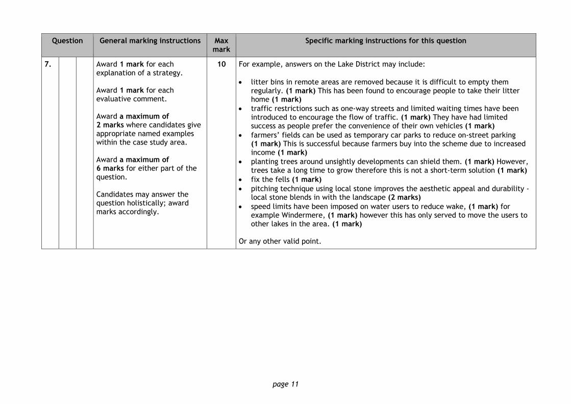
7. Award 1 mark for each explanation of a strategy. Award 1 mark for each evaluative comment. Award a maximum of 2 marks where candidates give appropriate named examples within the case study area. Award a maximum of 6 marks for either part of the question. Candidates may answer the question holistically; award marks accordingly.
10 For example, answers on the Lake District may include:
litter bins in remote areas are removed because it is difficult to empty them regularly. (1 mark) This has been found to encourage people to take their litter home (1 mark)
traffic restrictions such as one-way streets and limited waiting times have been introduced to encourage the flow of traffic. (1 mark) They have had limited success as people prefer the convenience of their own vehicles (1 mark)
farmers’ fields can be used as temporary car parks to reduce on-street parking (1 mark) This is successful because farmers buy into the scheme due to increased income (1 mark)
planting trees around unsightly developments can shield them. (1 mark) However, trees take a long time to grow therefore this is not a short-term solution (1 mark)
fix the fells (1 mark)
pitching technique using local stone improves the aesthetic appeal and durability - local stone blends in with the landscape (2 marks)
speed limits have been imposed on water users to reduce wake, (1 mark) for example Windermere, (1 mark) however this has only served to move the users to other lakes in the area. (1 mark)
Or any other valid point.
page 12
Question General marking instructions Max mark
Specific marking instructions for this question
8. (a) Award 1 mark for each relevant point.
6 Points may include:
census is a survey carried out every 10 years (1 mark)
each householder is asked to complete a detailed questionnaire about the number of people living in their home (1 mark)
householders answer other questions on their social, economic and cultural background (1 mark)
civil registration of births, deaths (1 mark) provides an up-to-date count between censuses (1 mark)
Scottish household survey is a continuous survey based on a random sample of the population (2 marks)
governments also collect data on migration, for example visa applications, and NHS records provide health data. (2 marks)
Or any other valid point.
page 13
Question General marking instructions Max mark
Specific marking instructions for this question
(b) Award 1 mark for each relevant point. Award a maximum of 2 marks where candidates give appropriate named examples to develop a point.
12 Points may include:
countries with many official languages have to translate their census forms (1 mark)
countries have to employ enumerators who can speak multiple languages. (1 mark) Nigeria has six major languages and hundreds of unofficial languages (1 mark)
low literacy levels - people are unable to complete the forms (1 mark)
size of the population - the sheer size of some populations makes it very difficult to conduct a census (1 mark)
inaccessibility makes some areas very difficult to reach within the time frame. (1 mark) For example, Indonesia has many islands spread over a large area (1 mark)
conflict can make it too dangerous for enumerators to enter (1 mark)
data can quickly become out-of-date due to the high death rate (1 mark)
cost - in developing countries, there may be higher priorities for spending, such as health care (1 mark)
many people in developing countries may be living in shanty towns so have no official address (1 mark)
ethnic tensions and internal political rivalries may lead to inaccuracies (1 mark) for example, northern Nigeria was reported to have inflated its population figures to secure increased political representation (1 mark)
illegal immigrants wish to avoid detection, (1 mark) for example Burmese migrants in Thailand (1 mark)
Nomadic people may be missed or counted twice as they cross international borders. (1 mark)
Or any other valid point.
page 14
Question General marking instructions Max mark
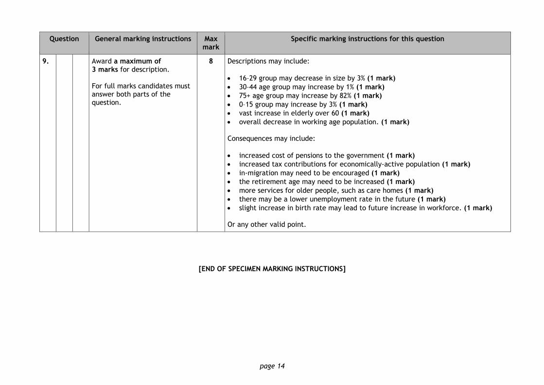
Specific marking instructions for this question
9. Award a maximum of 3 marks for description. For full marks candidates must answer both parts of the question.
8 Descriptions may include:
16–29 group may decrease in size by 3% (1 mark)
30–44 age group may increase by 1% (1 mark)
75+ age group may increase by 82% (1 mark)
0–15 group may increase by 3% (1 mark)
vast increase in elderly over 60 (1 mark)
overall decrease in working age population. (1 mark) Consequences may include:
increased cost of pensions to the government (1 mark)
increased tax contributions for economically-active population (1 mark)
in-migration may need to be encouraged (1 mark)
the retirement age may need to be increased (1 mark)
more services for older people, such as care homes (1 mark)
there may be a lower unemployment rate in the future (1 mark)
slight increase in birth rate may lead to future increase in workforce. (1 mark) Or any other valid point.
[END OF SPECIMEN MARKING INSTRUCTIONS]