Embed Size (px)
Citation preview
P12.194 FRONT: The FRONT RANGE OBSERVATIONAL NETWORK TESTBED
J.C. Hubbert1∗, P. Kennedy2, V. Chandrasekar2, S. Rutledge2, W.C. Lee1, V.N. Bringi2, J. Wilson1, D. Brunkow2, M. Dixon1,
T. Weckwerth1, J. George2, E. Loew1, J. Van Andel1, A. Phinney1, B. Bowie2, B. Rilling1, and S. Ellis1
1National Center for Atmospheric Research, Boulder, CO2Colorado State University, Fort Collins CO
1. INTRODUCTION
Since 2008 the personnel of the Colorado State Univer-sity CSU-CHILL National Radar Facility and the Na-tional Center for Atmospheric Research S-Pol Radar Fa-cility have been developing, with guidance from the Na-tional Science Foundation, a plan to more closely alignthe two radar’s architectures so that operation, develop-ment, maintenance and management of the two facilitieswould become more efficient. Initially, the radar groupsfocused on adopting common software and hardwarestructures including antenna control, radar process con-trol, signal processing, calibration, and data display ca-pabilities. These common structures allow the two radarsto be more streamlined in their operation, which easilyenables shared development. Another highlight of thisjoint activity paradigm is the Front Range OperationalNetwork Testbed (FRONT). The common streamlined in-frastructure enables close networking of these systemsforming the anchor points of an experimental infrastruc-ture. FRONT, formed by S-Pol, CSU-CHILL and CSU-Pawnee S-band radars, along with nearby NEXRADradars, brings a new observational capability to the com-munity.
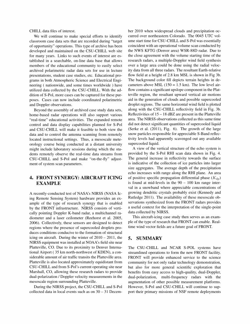
An important aspect of the envisioned FRONT mis-sion is moving S-Pol to a new site in Weld County, calledthe Firestone Site (near the intersection of Weld CountyRoads 18 and 19), in order to create a dual-Doppler, dual-polarization radar configuration. It is planned that radardata from the NEXRADs KFTG (Denver Airport) andKCYS (Cheyenne) will be integrated with CSU-CHILL,S-Pol and Pawnee (located near Nunn, CO) data thereby
∗NCAR/EOL, Boulder, Colorado 80307, email: [email protected]
forging a unique research infrastructure for the scientificcommunity. See Fig. 1 for the location of the radars inFRONT. An important aspect of the plan is that S-Polwill adopt an operational strategy successfully used atCSU-CHILL: S-Pol will be maintained in an operationalconfiguration when not remotely deployed on NSF fieldexperiments.
Similar to CSU-CHILL, S-Pol will be available to thescientific community while at its FRONT home base inpart for small data collection efforts roughly defined as20 hour projects. More significant collection efforts willstill need to go through the OFAP (Observing FacilitiesAssessment Panel) process. A FRONT request form canbe found at at http://www.eol.ucar.edu/front; however,FRONT as a network will not be available until Fall of2012.
The 42-kilometer baseline of Firestone field site andCSU-CHILL has excellent dual- Doppler geometry. Itis our vision that FRONT will afford the scientific com-munity a state-of-the-art dual-polarization, dual-Dopplernetwork that will provide a rich set of radar observa-tions for the wide spectrum of weather this region ex-periences. FRONT will also enhance educational activ-ities by expanding the data archive currently availablewith CSU-CHILL and by enabling hands on operationalexperience. To promote this, both CSU-CHILL and S-Pol will become remotely operable. An approved, re-mote user will be able to connect to a FRONT server, ac-cess the radar control GUI, set up scans and collect data.Shared engineering development between CSU-CHILLand NCAR/EOL (Earth Observing Laboratory) S-Pol re-search radars will provide the scientific community withthe following opportunities:
1. target-of-opportunity data collection on weather sit-uations that may be difficult to capture during ashort field campaign,
2. use of a long-term mesoscale and climate testbedfor testing new instruments and data quality evalua-tions, studying sensor integration technologies, val-idating numerical models, and testing advanced net-working concepts such as Virtual Operations Center( VOC ),
3. a low-cost experimental infrastructure for local fieldcampaigns and,
4. an expanded and diverse hands-on educa-tional/training and outreach experiences.
Correspondingly, FRONT has adopted the followingguiding vision and mission statements:Vision:FRONT: A testbed for innovative weather and climatetechnology development; leading, promoting and en-abling geoscience research and education.Mission:FRONT provides the atmospheric science communitywith a cost-efficient observational infrastructure for thecollection of comprehensive mesoscale data sets that in-clude the unique dual-polarization and multi-wavelengthremote sensing capabilities of the NCAR S-Pol and CSU-CHILL radars.FRONT is under the sponsorship of the National Sci-ence Foundation, the National Center for AtmosphericResearch and Colorado State University.
1.1. FRONT Measurement Capabilities
FRONT is anchored by two advanced, dual-polarimetricradars, the CSU-CHILL and S-Pol; however, FRONToffers much more measurement capability than just themain S-band frequencies of these radars. Both CSU-CHILL and S-Pol are adding second frequencies: forCSU-CHILL, X-band and for S-Pol, Ka-band. This com-bination of two high quality S-band polarimetric radarswith two additional frequencies for expanded microphys-ical profiling will establish a unique measurement capa-bility. The X-band component on CSU-CHILL will fea-ture an aligned common-axis, very narrow main antennabeam (0.33 degree ) enabling high resolution measure-ments that are precisely collocated with the S-band mea-surements. This will be accomplished by employing anew dual-frequency horn on CSU-CHILL. In contrast,the dual-frequency capability of S-Pol is achieved by theaddition of a Ka-band antenna mounted to the edge ofthe S-Pol’s center-fed, parabolic reflector antenna. Thedual-frequency capability of S-Pol enables the retrievalof humidity and cloud liquid water content (Ellis andVivekanandan 2010, 2011).
FRONT will be augmented by a VHF 3-D lightningnetwork. The Lightning Mapping Array (LMA) is athree-dimensional total lightning location system thatuses time of arrival of the lightning caused, electromag-netic pulses at a network of receiver stations (Rison et al.1999). Paul Krehbiel and colleagues will be installing theLMA network as part of the proposed NSF DC3 (DeepConvective Clouds and Chemistry) project. At the con-clusion of DC3 the LMA network will become part of
FRONT. Figure 2 shows the planned locations of the in-dividual LMA receivers.
In the future, FRONT will continue to be augmentedby real-time satellite data feeds, lidars, radiometers, sur-face stations, GPS receivers, rain gauges, profilers andother observational platforms as collaborative opportuni-ties and funding become available. Such a comprehensivenetwork would result in a unique observational test-bedfrom a worldwide perspective.
2. FRONT ENABLED SCIENCE
The Front Range of Colorado has hosted many fieldprojects in the past spanning studies of warm seasonand cool season weather events. A partial list of theseprojects includes: JAWS (Joint Airport Weather Stud-ies), CLAWS (Classify, Locate and Avoid Wind Shear),CINDE (The Convection Initiation and Downburst Ex-periment), POWS (Polarimetric Observations of WinterStorms), WISP (Winter Icing and Storms Project; twofield seasons), STERAO-A (Stratosphere-TroposphereExperiments: Radiation, Aerosols and Ozone), The FrontRange Pilot Project (for NASA Global Precipitation Mea-surement ground validation), and REFRACTT (Refrac-tivity Experiment for H2O Research and CollaborativeOperational Technology Transfer). Each of these projectsutilized Doppler wind measurements, as well as polari-metric measurements as this technology became avail-able. However, these projects did not have access to ad-vanced multiparameter measurements (dual-polarizationand multi-frequency) in the context of high quality 3-D wind fields such as will be provided by FRONT. Webelieve this infrastructure, enhanced by other measure-ments as described in the previous section, will motivatea series of experiments afforded by this advanced tech-nology. Below we provide a list of potential scientificprojects that would be possible with the FRONT. Theseprojects are envisioned to be of interest to the broaderscience community.
Numerical model data assimilation The routine avail-ability of high-resolution observations would pro-vide an excellent test-bed for high-resolution nu-merical forecast models that assimilate observa-tions, such as that used by the NCAR Short TermExplicit Prediction (STEP) program. Improvementresulting from new forecast model developmentscan be evaluated systematically, which cannot bedone by one-time field observations. It is also en-visioned that the combination of S-Pol and CSU-CHILL into a radar network will help focus re-sources and institutional expertise so that dual-polarimetric data are finally integrated into numeri-cal models.
Automated Data Quality and Advanced Signal Pro-cessing The collection of data by a well-calibratedradar, while crucial, is only the initial step in provid-ing the scientific community with meaningful mete-orological data – data artifacts must either be elimi-nated or identified and censored via signal process-ing to achieve high data quality. Effective and re-liable use of radar data for quantitative precipita-tion estimation (QPE), Nowcasting, data assimila-tion into weather models, hydrometeor classifica-tion and severe weather identification, depends di-rectly on high quality radar data. There are manyfactors that affect radar data quality some of whichinclude: radar calibration, NP (normal propaga-tion) and AP (anomalous propagation) ground clut-ter, low SNR (signal-to-noise-ratio), multiple tripechoes, radar malfunction, 3-body scattering, atten-uation, beam blockage, partial beam filling, biolog-ical scatterers, RF (radio frequency) interference,and data measurement uncertainty (i.e., error statis-tics).
Various signal-processing techniques have beendeveloped to effectively mitigate these data-contaminating effects, or at least to identify the con-taminated data so that it can be classified as non-meteorological echo; however, these techniques andalgorithms are still evolving and represent currentareas of intense research. Furthermore, with the ad-vances in fast digital radar technology, computersand gigabit Ethernet speeds, it is now possible toover sample radar return signals down to 20 m inrange, or better, and transmit these I and Q samplesto fast computers. The flexible, easy-to-programPC environment is then used to execute signal pro-cessing algorithms for data quality and radar prod-uct generation. This new radar processing technol-ogy, which exists on both CSU-CHILL and S-Pol,also makes possible real-time spectral processingespecially for dual-polarization measurements, a re-search area that has only begun to be explored.
The integrated facility would provide an excellentopportunity for developing and testing real-time au-tomated radar quality control techniques. The lackof such techniques limits the accuracy and utilityof real-time retrievals such as rain rate, cloud wa-ter content, humidity and wind. Furthermore, ef-fective real-time data quality control is essential forthe assimilation of these observations and retrievalsinto numerical models and nowcasting algorithms.The various radars at different wavelengths collect-ing large amounts of data would be an excellentlaboratory for developing and verifying calibrationmethods, attenuation and scattering effect correc-
tion techniques, range and velocity ambiguity mit-igation techniques, ground clutter detection and re-moval algorithms and precipitation identification al-gorithms. The expected outcomes of improved real-time data quality are improved QPE and QPF.
Orographic impacts The location of the radars affordsan excellent opportunity to study orographic pre-cipitation and mountain waves. The relationshipbetween orography and its impacts on precipita-tion are an ongoing research topic and have im-portant hydrologic implications. The orography af-fects both summer and winter precipitation, as wellas generating frequent mountain waves and turbu-lence. FRONT would be well suited to sample nu-merous events throughout the year. Measurementsof winds and polarimetric variables would provideinsight into precipitation formation processes incomplex terrain.
Summer convective storms Flash floods resulting fromterrain-induced heavy precipitation during warmseasons are extreme hazards in the U.S. The FrontRange experiences numerous summertime convec-tive storms. FRONT could support research in-terests requiring nearly continuous observations ofconvection initiation, evolution, and precipitationproduction within the radar domain, resources per-mitting. The real-time refractivity retrieval wouldprovide valuable low-level moisture information,which shows promise for convection initiation andevolution studies. Hail formation processes couldalso be studied with the combined polarimetric datafrom S-Pol and CSU-CHILL
Winter storms Front Range winter storms are complexwith both critical synoptic and mesoscale dynamicand microphysical processes occurring simultane-ously. Each must be better understood to improveforecasts and scientific research on precipitationproduction. Historically, Doppler radar-based stud-ies of heavy winter storms in the Front Range arefew and far between and most have been with sin-gle conventional radar data. Research on block-ing effects on winter storms and barrier jet evolu-tion would benefit greatly from multi-Doppler po-larimetric radar data. High-resolution wind andhydrometeor fields would help to assess the largenorth-south variations in precipitation along the ur-ban corridor. The value of radar refractivity in win-ter storms could be evaluated. The polarizationfields would also yield insight into the role of thedendritic zone and how its location and evolutionand depth contribute to precipitation production inthese storms. In combination with data on the rim-ing structure of the storms, the precipitation process
from start to finish could be analyzed. Such in-formation would yield immediate forecast benefits.Studies of winter storms are expected to benefit sig-nificantly from the short wavelength observations ofS-Pol (Ka band) and CSU-CHILL (X-band).
Radar retrieval development and testing The FrontRange laboratory would provide an excellentopportunity to develop and test radar retrievalalgorithms. This may include dual-Doppler pro-cessing to obtain the three-dimensional wind fieldsin real-time, particle identification algorithms tostudy microphysics, radar refractivity to obtainsurface moisture maps, dual-wavelength retrievaldevelopments for water vapor and cloud liquidwater retrievals and single-Doppler kinematic andthermodynamic retrievals, such as currently usedby the Variational Doppler Radar Analysis System.
Dual-polarimetric radar studies The close proximityof two research polarimetric radars provides aunique opportunity to study overlapping observa-tions of polarimetric variables. Possible appli-cations are automated data quality control, thedevelopment of advanced signal processing tech-niques and improved use of polarimetric variablesfor the identification and understanding of precip-itation microphysical variables. With the immi-nent polarimetric upgrade of the nations WSR-88Dradars, we expect the CSU-CHILL and S-Pol radarsto be in demand as development and demonstra-tion platforms for polarimetric-based algorithms.Indeed, once the KFTG and KCYS WSR-88Dsare upgraded, CSU-CHILL and S-Pol data can beused to validate the their measurements. In gen-eral, we anticipate a number of demands placedon CSU-CHILL and S-Pol once the nations WSR-88D radars are upgraded. While the WSR-88D net-work will make dual-polarized data available nationwide, the scanning strategies used by the NWS arefixed and are not at the discretion of NSF scientificresearch community. In addition, the NEXRADswill use the simultaneous horizontal and vertical(SHV) transmit technique which does not providethe full set of polarimetric variables and further-more, the data quality of the NEXRAD radars willnot be on par with S-Pol and CSU-CHILL due tocross-polar coupling that occurs in SHV mode oper-ation (Wang and Chandrasekar 2006; Hubbert et al.2010a,b). Thus, we envision the continued needfor high quality, S-band, dual-polarization measure-ments that CSU-CHILL and S-Pol can provide.
Triple Doppler operations Given the radar baselines ofCSU-CHILL, S-Pol and KFTG (near Denver Inter-national Airport) in FRONT, triple-Doppler mea-
surements are possible. Other triple-Doppler con-figurations could also be created. For example,a mobile C-band radar could be located east orwest of the baseline formed by CSU-CHILL and S-Pol. Inter-comparisons of dual-Doppler and triple-Doppler solutions could therefore be done.
3. EDUCATION, TRAINING and OUT-REACH
As noted earlier in this document, a primary result ofthe collaborative efforts between the NCAR and CSUradar groups will be the development of a local oper-ational structure that supports the efficient collection ofdata while the S-Pol and CSU-CHILL radars are locatedat their institutional home bases. Historically, the costsof conducting field projects that do not involve relocatingthese large S-Band radar systems have been modest (RE-FRACTT, STERAO-A, etc.). Also, the local availabilityof additional observing instrumentation (CSU-Pawnee,KFTG and KCYS WSR-88D radars; NCAR portablesounding systems, etc.) will permit the collection of evenmore comprehensive observations. The overall cost effi-ciency of home-based radar operations will particularlybenefit the small-scale ( $50K budget) educationally cen-tered research projects that the NSF has recently targetedfor deployment pool funding support.
Beyond the support of traditional, OFAP-allocatedfield projects, local operations can readily be conductedto collect target of opportunity polarimetric radar datasets. For example, experience has shown that havingthe radars operational during the mid-May through earlyAugust period will yield many possibilities for convec-tive storm observations in the Colorado Front Range areaproviding more opportunities to unravel the challengesof convective initiation. These “target of opportunity”activities will provide two primary benefits: (1) exercis-ing of the radar systems for testing and improvement oftheir technical capabilities. (i.e. real-time product gen-eration software, remotely-controlled / unattended radaroperational modes) (2) the resultant data sets should yieldmany “classroom case” examples that will be made avail-able to the educational community via the Internet.
To generally improve access to the S-Pol and CSU-CHILL data archives, it is envisioned that one of the even-tual results of the collaboration efforts will be the storageof the radar files in a common format at NCARs massdata storage facility. The archived data files from bothradars will be organized to allow interactive perusal usingVCHILL software. EOL’s current on-line data archive in-terface will be modified to provide educational interests(as well as scientific investigators) with standardized pro-cedures for selecting and downloading S-Pol and CSU-
CHILL data files of interest.We will continue to make special efforts to identify
classroom case data sets that are recorded during “targetof opportunity” operations. This type of archive has beendeveloped and maintained on the CSU-CHILL web sitefor many years. Links to such events of interest are es-tablished in a searchable, on-line data base that allowsmembers of the educational community to easily selectarchived polarimetric radar data sets for use in lecturepresentations, student case studies, etc. Educational pro-grams in both Atmospheric Science and Electrical Engi-neering ( nationwide, and some times worldwide ) haveutilized data collected by the CSU-CHILL. With the ad-dition of S-Pol, more cases can be captured for these pur-poses. Cases can now include coordinated polarimetricand Doppler observations.
Beyond the assembly of archived case study data sets,home-based radar operations will also support various“real-time” educational activities. The expanded remotecontrol and data display capabilities planned for S-Poland CSU-CHILL will make it feasible to both view thedata and to control the antenna scanning from remotelylocated instructional settings. Thus, a mesoscale mete-orology course being conducted at a distant universitymight include laboratory sessions during which the stu-dents remotely observe the real-time data streams fromCSU-CHILL and S-Pol and make “on-the-fly” adjust-ment of system scan parameters.
4. FRONT SYNERGY: AIRCRAFT ICINGEXAMPLE
A recently-conducted test of NASA’s NIRSS (NASA Ic-ing Remote Sensing System) hardware provides an ex-ample of the type of research synergy that is enabledby the FRONT infrastructure. NIRSS consists of verti-cally pointing Doppler K-band radar, a multichannel ra-diometer and a laser ceilometer (Reehorst et al. 2005,2006). Collectively, these sensors are designed to detectregions where the presence of supercooled droplets pro-duces conditions conducive to the formation of structuralicing on aircraft. During the winter of 2010 – 2011, theNIRSS equipment was installed at NOAA’s field site nearPlatteville, CO. Due to its proximity to Denver Interna-tional Airport ( 35 km north-northwest of KDEN), a con-siderable amount of air traffic transits the Platteville area.Platteville is also located approximately equidistant fromCSU-CHILL and from S-Pol’s current operating site nearMarshall, CO, allowing these research radars to providedual-polarization / Doppler velocity measurements in themesoscale region surrounding Platteville.
During the NIRSS project, the CSU-CHILL and S-Polcollected data in local events such as on 30 – 31 Decem-
ber 2010 when widespread clouds and precipitation oc-curred over northeastern Colorado. The 0045 UTC vol-ume start time for CSU-CHILL and S-Pol was essentiallycoincident with an operational volume scan conducted bythe NWS KFTG (Denver area) WSR-88D radar. Due tothe close agreement with the volume starting time of theresearch radars, a multiple-Doppler wind field synthesisover a large area could be done using the radial veloc-ity data from all three radars. The resultant Earth-relativeflow field at a height of 2.8 km MSL is shown in Fig 3b.The background color fill depicts terrain heights in de-cameters above MSL (150 = 1.5 km). The low level air-flow contains a significant upslope component in the Plat-teville region, the resultant upward vertical air motionsaid in the generation of clouds and possible supercooleddroplet regions. The same horizontal wind field is plottedalong with the CSU-CHILL reflectivity field in Fig. 3b.Reflectivities of 15 – 18 dBZ are present in the Plattevillearea. The NIRSS observations collected as this same timedid not detect significant quantities of supercooled liquid(Serke et al. (2011), Fig. 6). The growth of the largesnow particles responsible for appreciable S-Band reflec-tivity levels had apparently scavenged out any availablesupercooled liquid.
A view of the vertical structure of the echo system isprovided by the S-Pol RHI scan data shown in Fig. 4.The general increase in reflectivity towards the surfaceis indicative of the collection of ice particles into largersize aggregates. The average depth of the precipitationecho increases with range along the RHI plane. An areaof positive specific propagation differential phase (Kdp)is found at mid-levels in the 90 – 100 km range inter-val in a snowband where appreciable concentrations ofgrowing dendritic crystals probably exist (Kennedy andRutledge 2011). The availability of these mesoscale ob-servations synthesized from the FRONT radars providesa useful context for the interpretation of the single-pointdata collected by NIRSS.
This aircraft-icing case study then serves as an exam-ple of the type of research that FRONT can enable. Real-time wind vector fields are a future goal of FRONT.
5. SUMMARY
The CSU-CHILL and NCAR S-POL systems havestreamlined operations to form the new FRONT facility.FRONT will provide enhanced service to the sciencecommunity for not only radar technology demonstration,but also for more general scientific exploration thatbenefits from easy access to high-quality, dual-Doppler,dual-polarization, multi-frequency radars with theaugmentation of other possible measurement platforms.However, S-Pol and CSU-CHILL will continue to sup-port their primary missions of NSF remote deployments
as required. Because of the streamlined subsystemdevelopments in the two radars, they can support eachother in development and deployment activities. Forexample developmental activities in CSU-CHILL canbe more readily implemented in S-Pol. Since S-Polwill be operational in between deployments as a part ofFRONT, S-Pol will always be in a state of operationalreadiness for NSF field deployments. FRONT willavailable to the research community by Fall 2012 andwill be requestable for 20-hour projects in a stream-lined process. A FRONT request form is available athttp://www.eol.ucar.edu/front.
AcknowledgmentBoth the CSU-CHILL and NCAR S-Pol radars are
supported by the National Science Foundation. Anyopinions, findings and conclusions or recommendationsexpressed in this publication are those of the authorsand do not necessarily reflect the views of the NationalScience Foundation.
ReferencesEllis, S. and J. Vivekanandan, 2010: Water vapor esti-
mates using simultaneous dual-wavelength radar ob-servations. Radio Sci., 45, 15pp.
— 2011: Liquid water content estimates using simultane-ous S- and Ka-band radar measurements. Radio Sci.,46, 15pp.
Hubbert, J., S. Ellis, M. Dixon, and G. Meymaris, 2010a:Modeling, error analysis and evaluation of dual po-larization variables obtained from simultaneous hori-zontal and vertical polarization transmit radar. Part I:Modeling and antenna errors. J. Atmos. Oceanic Tech-nol., 27, 1583–1598.
— 2010b: Modeling, error analysis and evaluation ofdual polarization variables obtained from simultane-ous horizontal and vertical polarization transmit radar.Part II: Experimental data. J. Atmos. Oceanic Technol.,27, 1599–1607.
Kennedy, P. C. and S. A. Rutledge, 2011: S-band dual-polarization radar observations of winter storms. J.Appl. Meteor., 50, 844–858.
Reehorst, A., D. Brinker, and T. Ratvasky, 2005: NASAIcing Remote Sensing System: comparisons fromAIRSII. Technical report, NASA, technical Memoran-dum 2005-213592.
Reehorst, A., M. Politovich, S. Zednick, G. Issac, andS. Cober, 2006: Progress in the development of prac-tical remote detection of icing conditions. Technicalreport, NASA, technical Memorandum 2006-214242.
Rison, W., R. J. Thomas, P. R. Krehbiel, T. Hamlin, andJ. Harlin, 1999: A gps-based three-dimensional light-ning mapping system: Initial observations in centralnew mexico. J. Geophy. Res. Let., 26, 3573–4576.
Serke, D., J. Hubbert, A. Reehorst, M. Politovich,P. Kennedy, M. Dixon, S. Ellis, C. Johnston, D. Albo,and S. Landolt: 2011, In-flight icing hazard verifi-cation with NASA’s icing remote sensing system fordevelopment of a NEXRAD icing hazard level algo-rithm. SAE 2011 International Conference on Aircraftand Engine Icing and Ground Deicing, SAE Interna-tional, Chicago, IL., p12.
Wang, Y. and V. Chandrasekar, 2006: Polarization isola-tion requirements for linear dual-polarization weatherradar in simultaneous transmission mode of operation.IEEE Trans. Geosc. and Remote Sen., 44, 2019–2028.
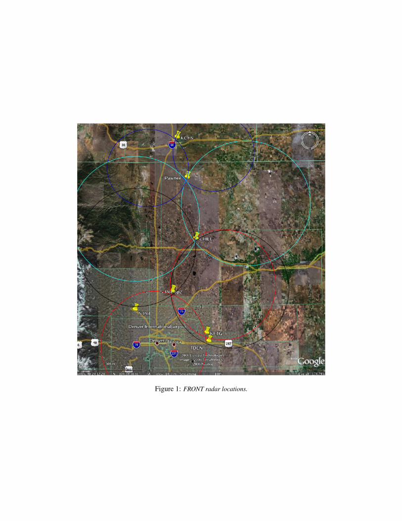
Figure 1: FRONT radar locations.
Figure 2: The locations, marked in green, of the receivers for the LMA to be deployed in the FRONT domain. Theyellow markers, from top to bottom, show the location of the Pawnee, CSU-CHILL and S-Pol radars. The CSU-CHILLmarker is located close to Greeley and is obscured by a LMA marker. Figure supplied by New Mexico Tech.
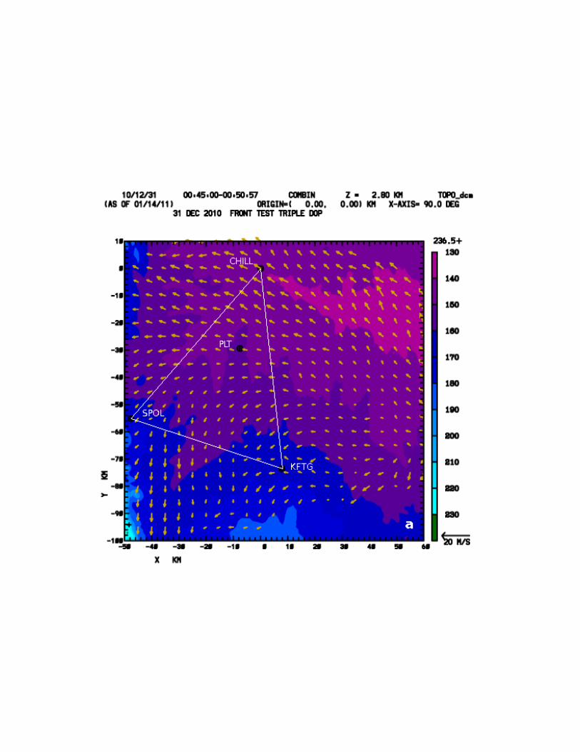
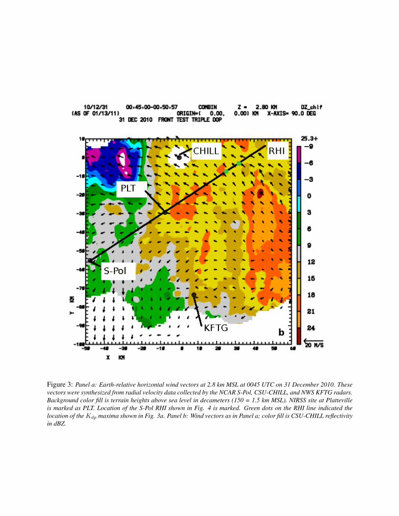
Figure 3: Panel a: Earth-relative horizontal wind vectors at 2.8 km MSL at 0045 UTC on 31 December 2010. Thesevectors were synthesized from radial velocity data collected by the NCAR S-Pol, CSU-CHILL, and NWS KFTG radars.Background color fill is terrain heights above sea level in decameters (150 = 1.5 km MSL). NIRSS site at Plattevilleis marked as PLT. Location of the S-Pol RHI shown in Fig. 4 is marked. Green dots on the RHI line indicated thelocation of the Kdp maxima shown in Fig. 3a. Panel b: Wind vectors as in Panel a; color fill is CSU-CHILL reflectivityin dBZ.
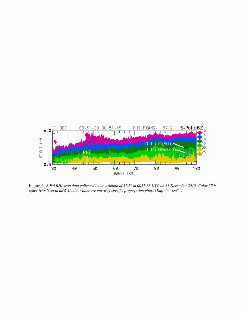
Figure 4: S-Pol RHI scan data collected on an azimuth of 57.2o at 0051:38 UTC on 31 December 2010. Color fill isreflectivity level in dBZ. Contour lines are one-way specific propagation phase (Kdp) in ◦ km−1.


![Designing for Technology-Enabled Social-Ecological Resilience · deal with many stresses such as continued disrupted/unstable educa-tional and living situation [6] and discrimination](https://img.pdfslide.net/doc/110x75/6053f9b8d93c61588d2cf0a8/designing-for-technology-enabled-social-ecological-resilience-deal-with-many-stresses.jpg)