Embed Size (px)
Citation preview
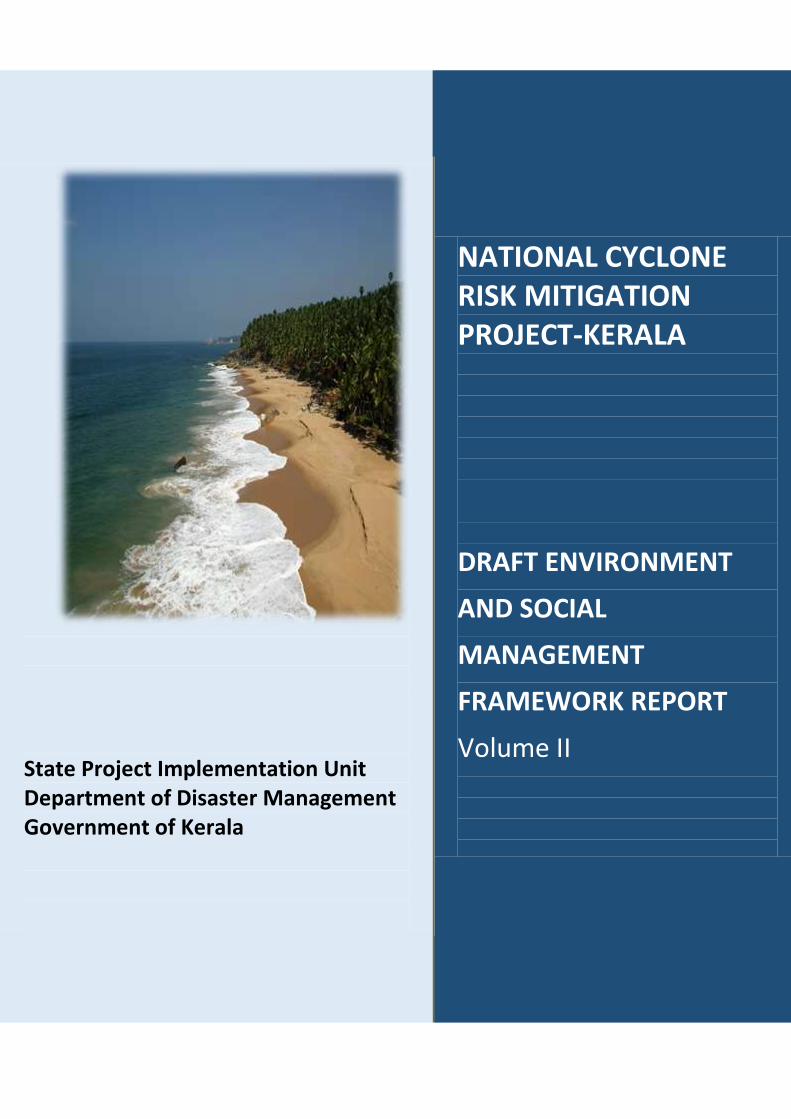
State Project Implementation Unit Department of Disaster Management Government of Kerala
NATIONAL CYCLONE RISK MITIGATION PROJECT-KERALA
DRAFT ENVIRONMENT
AND SOCIAL
MANAGEMENT
FRAMEWORK REPORT
Volume II

2
Acronyms
ASI Archaeological Survey Of India
CRZ Coastal Regulation Zone DPIU District Project Implementation Unit
EA Environmental Assessment EAC Expert Appraisal Committee EIA Environmental Impact Assessment
EMP Environmental Management Plan ESMF Environmental And Social Management
Framework GEMP Generic Environment Management Plan
GOI Government Of India GOK Government Of Kerala GPS Global Positioning System HTL High Tide Line LTL Low Tide Line
MOEF Ministry Of Environment & Forest MPCS Mutli Purpose Cyclone Shelter
NCRMP National Cyclone Risk Mitigation Project NDMA National Disaster Management
Authority NOC No Objection Certificate PCB Pollution Control Board
PMU Project Management Unit SIA Social Impact Assessment
SPIU State Project Implementation Unit TOR Terms of Reference

3
Index 1. Introduction 4 2. Kasargod 6
1. MPCS at Koipady Village 9 2. MPCS at Pullur Village 19 3. MPCS at Kudlu (Shiribagilu) Village 28
3. Kannur 37 1. MPCS at Kannur-2 Village 40 2. MPCS at Kathirur Village 49
4. Kozhikode 58 1. MPCS at Thikkodi Village 61
2. MPCS at Kasaba Village 70 5. Malappuram 78
1. MPCS at Vettom Village 81 2. MPCS at Perumpadappu Village 91
6. Thrissur 100 1. MPCS at Azhikode Village 103
2. MPCS at Kadappuram Village 112 7. Ernakulam 121
1. MPCS at Pallipuram Village 125 2. MPCS at Kumbalanghi Village 133
3. MPCS at Moothakunnam Village 143 4. MPCS at Njarakkal Village 152
5. MPCS at Puthenvelikara Village 157 8. Alappuzha 162
1. MPCS at Pallipad Village 165 2. MPCS at Kumarapuram Village 174
3. MPCS at Cheruthana Village 184 4. MPCS at Purakkad Village 194 5. MPCS at Mararikulam North Village 204
6. MPCS at Kainakari North Village 213 9. Kollam 225
1. MPCS at Karunagappally Village 228 2. MPCS at Thazhava Village 239
3. MPCS at Vadakkevila Village 248 10. Thiruvananthapuram 256
1. MPCS at Muttathara Village 259 11. ESMF Checklists 267 12. Format for entering update/revision 433

4
1. Introduction
The key steps involved in Environmental and Social Screening that are laid down in the
Environment and Social Management Framework (ESMF) Phase II for project States under
NCRMP Phase II is as follows:
Step 1: Ascertain presence of any environmentally sensitive areas as detailed in screening
criteria section Part-B and w.r.t. CRZ zones during site identification.
Step 2: Confirm applicability of regulations and whether any of the sub-projects are
prohibited as per the existing law / regulations in the proposed sites. Wherein the proposed
activity is restricted, Step 1 needs to be performed again.
Step 3: Conduct reconnaissance site visits for ground truthing to incorporate additional
information.
Step 4: Revisit the screening check list and ascertain outcomes of the Part B (2) and Part C
(2) of the screening checklist. Undertake the detailed screening process for all investments
in consultation with the line department.
Step 5: Determine the requirement of an EIA / SIA study & its scope and other applicable
rules /regulations and clearances.
Step 6: If EIA/SIA is required, then:
Step 6.1 Prepare ToR for EIA / SIA studies and appoint Environment and Social
Management Consultants.
Step 6.2: Conduct EIA / SIA as per the scope defined in the ToR along with preparation
of the detailed DPR documents.
Step 8: Check for applicable NOC / Clearances from MoEF/ State PCB’s etc as applicable
Step 9: Ensure integration of GEMP and / or Specific EMP measures (as applicable) with bid
documents and contract provisions.
Step 10: Project implementation and monitoring to ensure EMP / GEMP implementation.
ESMF Volume II document narrates the results of Environmental and Social screening of the sites
identified and screened across the nine coastal districts of the State. The reports of the selected sites
(as per G.O (Rt) no. 641/DMD/2016 dated 28.01.2016) have been partitioned into three sections –
ESMF Checklist, Brief Report, report of Panchayath/ Municipal Corporation meeting on construction of

5
MPCS at the site. Details of sites proposed from the District Administration of nine coastal districts but
not selected for the project are also detailed in this document.
ESMF Volume II is an ‘up-to-date’ or a ‘live document’ allowing revision, from time to time
when necessary. Certain aspects not foreseen at preconstruction phase of the project may not
be not included in this document and such aspects needs to be assessed and appropriate
modifications will be incorporated in to the document. For example, any variation in the building
design would be assessed and appropriate changes will be incorporated by updating the said
Framework. Revisions will also cover and update any changes/modifications introduced in the
legal/regulatory regime of the country/ state. Also, based on the experience of application and
implementation of this framework, the provisions and procedures would be updated, as
appropriate in consultation with the World Bank and the implementing agencies/departments.

6
2. District: Kasargod

7
Kasargod District
Well-known for coir and handloom industries, Kasaragod, is the northernmost district of
Kerala. To the north and east of the district is Karnataka State and to the south and west is
Kannur District and Arabian Sea respectively. The district lies between North latitudes 12˚ 2' and
12˚ 45’ and East longitudes 74˚ 52' and 75˚ 26’. The district has a total area of 1989 Sq.Km with
70 kilometer long coastline and falls in the North Kerala Coast. Kasaragod District consists
Cannanore Coast, Kasaragod Table Land and Peringom Mattannur Undulating Upland.
The sites selected for construction of Multipurpose Cyclone shelters in Kasargod District
are at Koipady Village, Kudlu (Shiribagilu) village and Pullur village of Kasargod District.
Profile of Kasargod
Headquarters Kanjhangad
Total Population 1,307,375
Male 628,613
Female 678,762
Population Growth 8.58%
Density/Km2 657
Number of Taluks 4
Number of Villages 75
Number of Panchayath Wards 39
Forest Area 115.09 Km2
Average Rainfall 3,500mm
Temperature Min: 22˚C
Max:37˚C
Number of major rivers 12
Major Soil Coastal plain soil

8
Vulnerability Assessment of the District
The banks of major rivers Chandragiri, Kariangode, Shiriya, Uppala their rivulets and
paddy fields are prone to flooding during monsoon. The table below details the vulnerability
area of the district to various hydro-meteorological hazards.
Taluks in
the
district
Flood Coastal Erosion Storm
surge/
Tsunami
inundation
Low High
Without
seawall
With sea wall
Area
km2
Are
a %
Lengt
h Km
Lengt
h %
Lengt
h Km
Lengt
h %
Lengt
h Km
Lengt
h %
Are
a
km2
Are
a %
Hosdurg 87.1 8.8 15.0 30.5 1.3 2.6 1.4 2.9 32.6 3.3
Kasargod
e
111.
7
11.2 13.3 34.5 - - 2.9 7.6 18.2 1.8
Total 198.
8
10.0 28.3 32.1 1.3 1.5 4.3 4.9 50.8 2.6

9
Source: National Centre for Earth Science Studies

10
1. MPCS AT KOIPADY VILLAGE
PART A: ESMF CHECKLIST
Part B: Ascertaining whether the site is a prohibited site PART B1: List of sites where sub-projects are prohibited
Is the sub-project located in whole or within any of the following environmentally sensitive area?
Remarks if any
Biosphere reserve No
National Park No
Wildlife/Bird sanctuary No
Game reserve No
Tiger reserve/elephant reserve No
Wetland No
Important bird areas No
Coastal area with corals No
Mangrove area No
Estuary with mangroves No
Part A: General Information about the sub-project
Sub Project id NCRMP/KER/KSD/ HOS/KOIPADY -1
Type of proposed sub-project activity MPCS
Location of the sub project activity
State Kerala
District Kasargod
Taluk Manjeshwar
Village Koipady
Panchayath/Municipal Corporation Kumbla Gramapanchayath
Survey Number Re-Survey number: 168/1pt
Latitude 12⁰ 35' 40.2”N
Longitude 74⁰ 56' 49.1"E
Mean Sea Level 49m
Size of the sub-project
Cyclone Shelter – approx. built up area
Land requirement for the sub project (in Ha or m2)
Total Requirement
a. Private Land Nil
b. Government Land 900 SQ.M
c. Forest Land Nil
Existing Land use Barren land
Approach roads
Road name Kumbla Police Station road
Existing road Length: 500m ROW: 8m
Proposed road No approach road proposed
Boundary wall requirement No
11
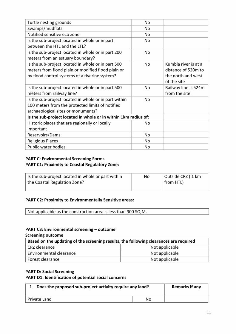
Turtle nesting grounds No
Swamps/mudflats No
Notified sensitive eco zone No
Is the sub-project located in whole or in part between the HTL and the LTL?
No
Is the sub-project located in whole or in part 200 meters from an estuary boundary?
No
Is the sub-project located in whole or in part 500 meters from flood plain or modified flood plain or by flood control systems of a riverine system?
No
Kumbla river is at a distance of 520m to the north and west of the site
Is the sub-project located in whole or in part 500 meters from railway line?
No Railway line is 524m from the site.
Is the sub-project located in whole or in part within 100 meters from the protected limits of notified archaeological sites or monuments?
No
Is the sub-project located in whole or in within 1km radius of:
Historic places that are regionally or locally important
No
Reservoirs/Dams No
Religious Places No
Public water bodies No
PART C: Environmental Screening Forms PART C1: Proximity to Coastal Regulatory Zone:
Is the sub-project located in whole or part within the Coastal Regulation Zone?
No Outside CRZ ( 1 km from HTL)
PART C2: Proximity to Environmentally Sensitive areas:
Not applicable as the construction area is less than 900 SQ.M.
PART C3: Environmental screening – outcome Screening outcome
Based on the updating of the screening results, the following clearances are required
CRZ clearance Not applicable
Environmental clearance Not applicable
Forest clearance Not applicable
PART D: Social Screening PART D1: Identification of potential social concerns
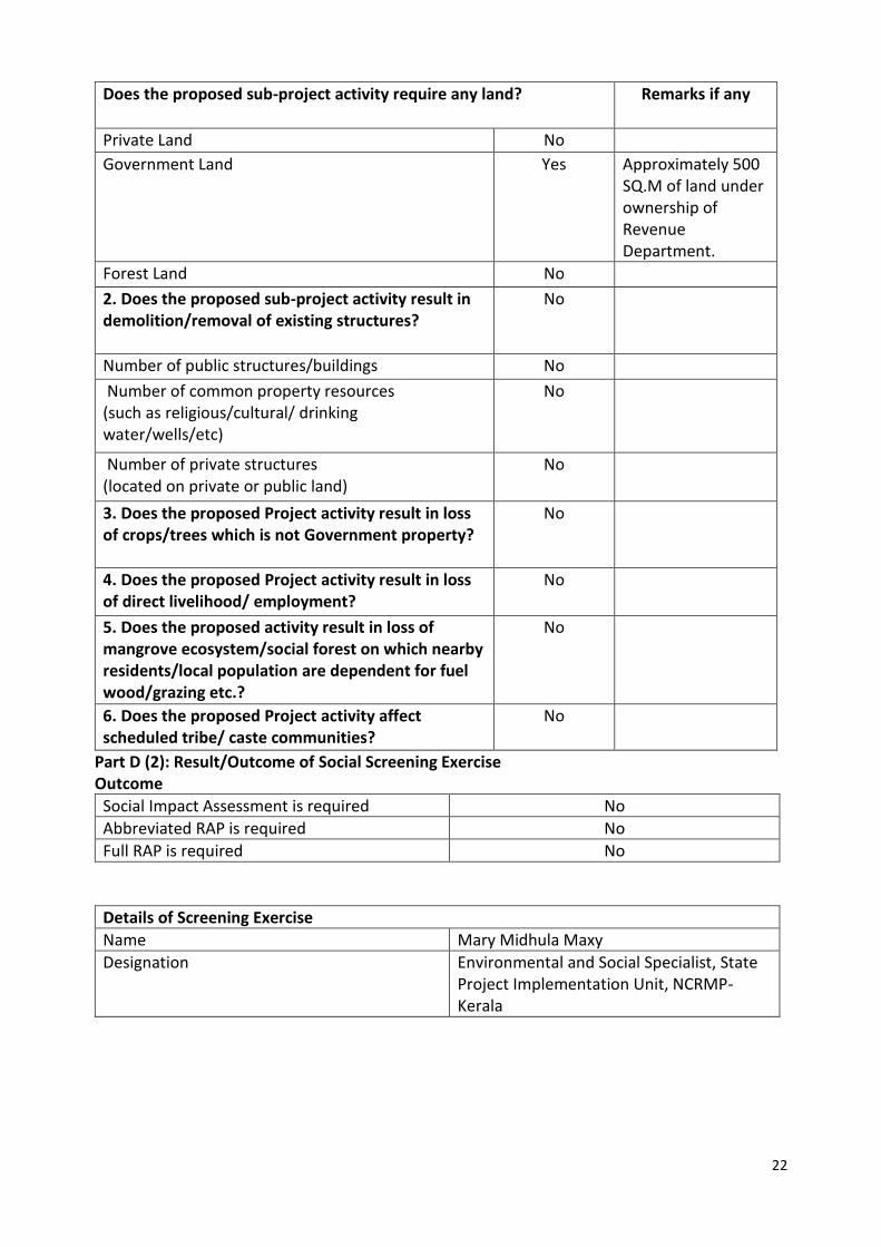
1. Does the proposed sub-project activity require any land? Remarks if any
Private Land No

12
Part D (2): Result/Outcome of Social Screening Exercise Outcome
Social Impact Assessment is required No
Abbreviated RAP is required No
Full RAP is required No
Government Land Yes 900 SQ.M of land in Ownership of Education department
Forest Land No
2. Does the proposed sub-project activity result in demolition/removal of existing structures?
No
Number of public structures/buildings No
Number of common property resources (such as religious/cultural/ drinking water/wells/etc)
No
Number of private structures (located on private or public land)
No
3. Does the proposed Project activity result in loss of crops/trees which is not Government property?
No
4. Does the proposed Project activity result in loss of direct livelihood/ employment?
No
5. Does the proposed activity result in loss of mangrove ecosystem/social forest on which nearby residents/local population are dependent for fuel wood/grazing etc.?
No
6. Does the proposed Project activity affect scheduled tribe/ caste communities?
No
Details of Screening Exercise
Name Mary Midhula Maxy
Designation Environmental and Social Specialist, State Project Implementation Unit, NCRMP-Kerala
13
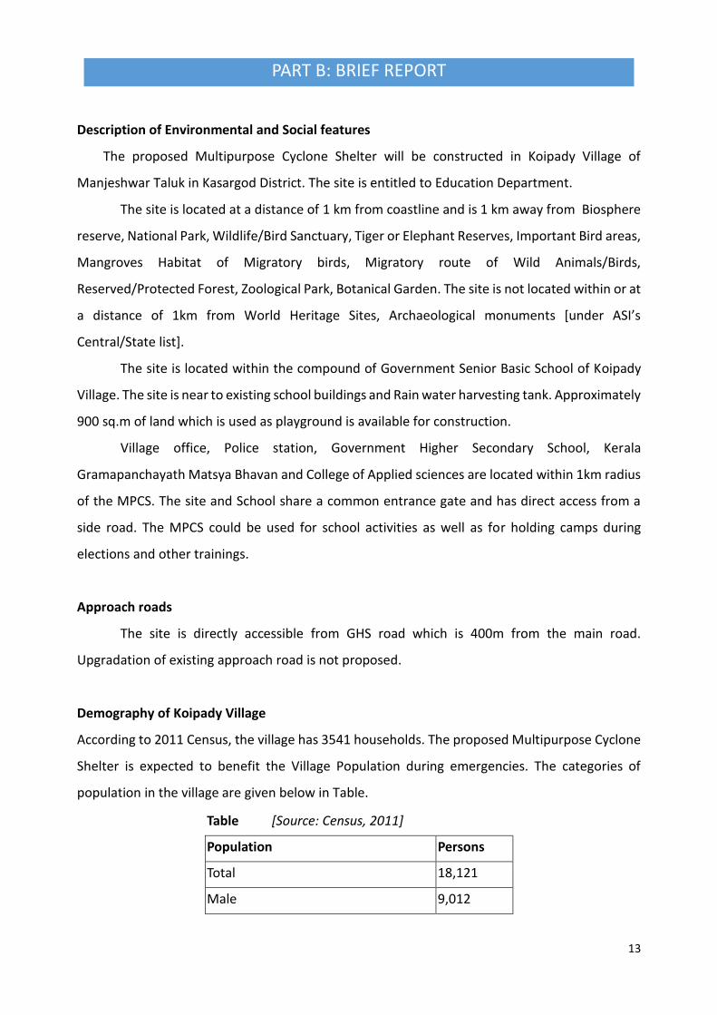
PART B: BRIEF REPORT
Description of Environmental and Social features
The proposed Multipurpose Cyclone Shelter will be constructed in Koipady Village of
Manjeshwar Taluk in Kasargod District. The site is entitled to Education Department.
The site is located at a distance of 1 km from coastline and is 1 km away from Biosphere
reserve, National Park, Wildlife/Bird Sanctuary, Tiger or Elephant Reserves, Important Bird areas,
Mangroves Habitat of Migratory birds, Migratory route of Wild Animals/Birds,
Reserved/Protected Forest, Zoological Park, Botanical Garden. The site is not located within or at
a distance of 1km from World Heritage Sites, Archaeological monuments [under ASI’s
Central/State list].
The site is located within the compound of Government Senior Basic School of Koipady
Village. The site is near to existing school buildings and Rain water harvesting tank. Approximately
900 sq.m of land which is used as playground is available for construction.
Village office, Police station, Government Higher Secondary School, Kerala
Gramapanchayath Matsya Bhavan and College of Applied sciences are located within 1km radius
of the MPCS. The site and School share a common entrance gate and has direct access from a
side road. The MPCS could be used for school activities as well as for holding camps during
elections and other trainings.
Approach roads
The site is directly accessible from GHS road which is 400m from the main road.
Upgradation of existing approach road is not proposed.
Demography of Koipady Village
According to 2011 Census, the village has 3541 households. The proposed Multipurpose Cyclone
Shelter is expected to benefit the Village Population during emergencies. The categories of
population in the village are given below in Table.
Table [Source: Census, 2011]
Population Persons
Total 18,121
Male 9,012

14
Female 9,109
In the age group 0-6 years 2,006
Scheduled Castes (SC) 882
Scheduled Tribes (ST) 217
Literates 14,504
Illiterate 3,617
Worker 7,098
Non Worker 11,023
Legal Clearances
Environmental Clearance
As per EIA notification, 2006 environmental clearance is mandatory for projects with built
up area more than 20,000 sq mt. Since, the built up area of Koipady MPCS is only 1800 sq.mt,
project does not necessitate any Environmental clearance.
CRZ Clearance
Koipady MPCS is 1 km from the High Tide Line and is not within the Coast Regulation Zone.
Hence, the project does not require clearance as per CRZ notification, 2011.
Forest Clearance
Since, diversion of forest area or felling of roadside plantation is not required during any
phase of construction of Koipady MPCS clearance as per Forest (Conservation) Act, 1980 is not
applicable.
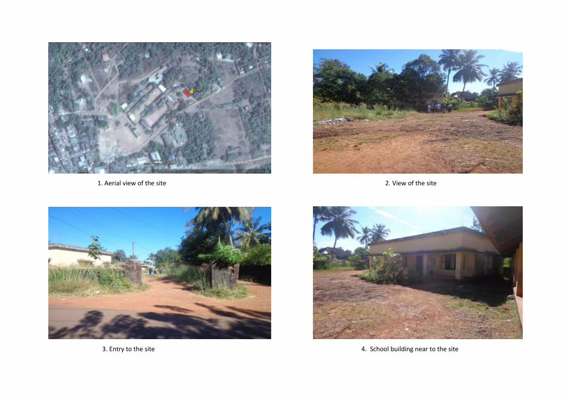
1. Aerial view of the site 2. View of the site
3. Entry to the site 4. School building near to the site

16
GIS map of MPCS at Koipady Village

PART C: PANCHAYATH RESOLUTION
District Kasargod
Village Koipady
Panchayath Kumbla Gramapanchayath
Place Kumbla
Date 20.04.2016

18

19
Summary of the Panchayath meeting decision:
1. The Kumbla Gramapanchayath discussed on decision taken in Government Order: G.O
(Rt) no. 641/2016/DMD dated 28.01.2016 to construct a Multi-Purpose Cyclone Shelter
in the compound of GSBS, Kumbla of Koipady Village as informed through Letter no.
G3/1082/10 dared 31.03.2016 from Tahsildar of Manjeshwar.
2. The Panchayath has directed the Local Self Government Department and Head Master of the
school to submit a report in this regard.

20
Part A: General Information about the sub-project
Sub Project id NCRMP/KER/KSD/ HOS/PULLUR -1
Type of proposed sub-project activity MPCS
Location of the sub project activity
State Kerala
District Kasargod
Taluk Hosdurg
Village Pullur
Panchayath/Municipal Corporation Pullur-Periya Gramapanchayath
Survey Number Survey number: 110/1A3A
Latitude 12⁰ 21' 28.2”N
Longitude 75⁰ 6' 1.4"E
Mean Sea Level 49m
Size of the sub-project
Cyclone Shelter – approx. built up area
Land requirement for the sub project (in Ha or m2)
Total Requirement
a. Private Land Nil
b. Government Land 1300 SQ.M
c. Forest Land Nil
Existing Land use Barren land
Approach roads
Road name Pullur-Pannikunnu road (Haripuram Mengoth Kodavalam Road)
Existing road ROW: 8m
Proposed road No approach road proposed.
Boundary wall requirement No
Part B: Ascertaining whether the site is a prohibited site PART B1: List of sites where sub-projects are prohibited
Is the sub-project located in whole or within any of the following environmentally sensitive area?
Remarks if any
Biosphere reserve No
National Park No
Wildlife/Bird sanctuary No
Game reserve No
Tiger reserve/elephant reserve No
Wetland No The site is 800m from the stream of Chithari river.
Important bird areas No
2. MPCS AT PULLUR VILLAGE
PART A: ESMF CHECKLIST

21
Coastal area with corals No
Mangrove area No
Estuary with mangroves No
Turtle nesting grounds No
Swamps/mudflats No
Notified sensitive eco zone No
Is the sub-project located in whole or in part between the HTL and the LTL?
No
Is the sub-project located in whole or in part 200 metres from an estuary boundary?
No
Is the sub-project located in whole or in part 500 meters from flood plain or modified flood plain or by flood control systems of a riverine system?
No
Is the sub-project located in whole or in part 500 meters from railway line?
No
Is the sub-project located in whole or in part within 100 meters from the protected limits of notified archaeological sites or monuments?
No
Is the sub-project located in whole or in within 1km radius of:
Historic places that are regionally or locally important
No
Reservoirs/Dams No
Religious Places No
Public water bodies No
PART C: Environmental Screening Forms PART C1: Proximity to Coastal Regulatory Zone:
Is the sub-project located in whole or part within the Coastal Regulation Zone?
No Outside CRZ ( 4.5 km from HTL)
PART C2: Proximity to Environmentally Sensitive areas:
Not applicable as the construction area is less than 1300 SQ.M.
PART C3: Environmental screening – outcome Screening outcome
Based on the updating of the screening results, the following clearances are required
CRZ clearance Not applicable
Environmental clearance Not applicable
Forest clearance Not applicable
PART D: Social Screening PART D1: Identification of potential social concerns
22
Part D (2): Result/Outcome of Social Screening Exercise Outcome
Social Impact Assessment is required No
Abbreviated RAP is required No
Full RAP is required No
Details of Screening Exercise
Name Mary Midhula Maxy
Designation Environmental and Social Specialist, State Project Implementation Unit, NCRMP-Kerala
Does the proposed sub-project activity require any land? Remarks if any
Private Land No
Government Land Yes Approximately 500 SQ.M of land under ownership of Revenue Department.
Forest Land No
2. Does the proposed sub-project activity result in demolition/removal of existing structures?
No
Number of public structures/buildings No
Number of common property resources (such as religious/cultural/ drinking water/wells/etc)
No
Number of private structures (located on private or public land)
No
3. Does the proposed Project activity result in loss of crops/trees which is not Government property?
No
4. Does the proposed Project activity result in loss of direct livelihood/ employment?
No
5. Does the proposed activity result in loss of mangrove ecosystem/social forest on which nearby residents/local population are dependent for fuel wood/grazing etc.?
No
6. Does the proposed Project activity affect scheduled tribe/ caste communities?
No
23
Description of Environmental and Social features
The proposed Multipurpose Cyclone Shelter will be constructed in Pullur Village of Hosdurg taluk in
Kasargod District. The site is entitled to Revenue Department.
The site is located at a distance of 4.5 km from coastline and is 1 km away from Biosphere reserve,
National Park, Wildlife/Bird Sanctuary, Tiger or Elephant Reserves, Important Bird areas, Mangroves
Habitat of Migratory birds, Migratory route of Wild Animals/Birds, Reserved/Protected Forest, Zoological
Park, Botanical Garden.
The site is not located within or at a distance of 1km from World Heritage Sites, Archaeological
monuments [under ASI’s Central/State list].
The site is a barren land with gentle slopes towards the southern portion. Village office of Pullur
is located to the immediate north of the site. Government Upper Primary School and Industrial Training
Institute is located to the west of the site.
Approach roads
The site is directly accessible from the nearby Pullur Pannikunnu (Mengoth Kodavalam road) main
road. Uupgradation of existing approach road is not proposed.
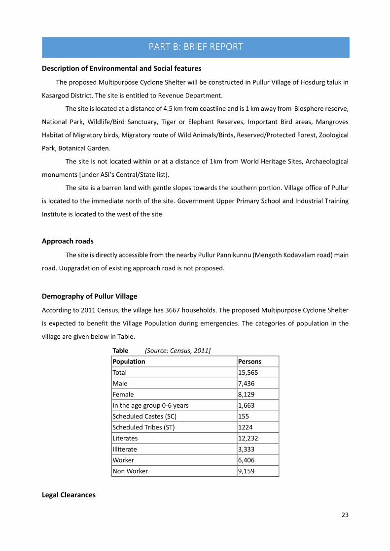
Demography of Pullur Village
According to 2011 Census, the village has 3667 households. The proposed Multipurpose Cyclone Shelter
is expected to benefit the Village Population during emergencies. The categories of population in the
village are given below in Table.
Table [Source: Census, 2011]
Population Persons
Total 15,565
Male 7,436
Female 8,129
In the age group 0-6 years 1,663
Scheduled Castes (SC) 155
Scheduled Tribes (ST) 1224
Literates 12,232
Illiterate 3,333
Worker 6,406
Non Worker 9,159
Legal Clearances
PART B: BRIEF REPORT

24
Environmental Clearance
As per EIA notification, 2006 environmental clearance is mandatory for projects with built up area
more than 20,000 sq mt. Since, the built up area of Pullur MPCS is only 580 sq.mt, project does not
necessitate any Environmental clearance.
CRZ Clearance
Pullur MPCS is 4.5 km from the High Tide Line and is not within the Coast Regulation Zone. Hence,
the project does not require clearance as per CRZ notification, 2011.
Forest Clearance
Since, diversion of forest area or felling of roadside plantation is not required during any phase of
construction of Pullur MPCS clearance as per Forest (Conservation) Act, 1980 is not applicable.

1. Aerial view of the site 2. View of the site (Village Office building can be seen)
3 and 4. Access road to the site

GIS map of MPCS at Pullur Village

27
District Kasargod
Village Pullur
Panchayath Pullur Periya Gramapanchayath
Place Pullur
Date 21.05..2016
PART C: PANCHAYATH RESOLUTION

28
Summary of the Panchayath meeting decision:
1. The Pullur Periya Gramapanchayath discussed on decision taken in Government Order: G.O
(Rt) no. 641/2016/DMD dated 28.01.2016 on 28.01.2016 for constructing a Multi-Purpose
Cyclone Shelter in Pullur Village.
2. The Panchayath agreed and accepted the decision of the Government to construct a MPCS
at Resurvey no: 110/1A3A of Pullur Village.
3. The Panchayath decided to inform the Authorities regarding the consent of the Panchayath
in constructing the Multi-Purpose Cyclone Shelter.
4. The Panchayath in decision no. 37/16 (3) dated 31/05/2016 has informed the District
Collector Kasargod regarding the decision taken by Pullur Periya Gramapanchayath.

29
3. MPCS AT KUDLU (SHIRIBAGILU) VILLAGE
PART A: ESMF CHECKLIST
Part A: General Information about the sub-project
Sub Project id NCRMP/KER/KSD/ KAS/KUDLU-1
Type of proposed sub-project activity MPCS
Location of the sub project activity
State Kerala
District Kasargod
Taluk Kasargod
Village Kudlu (Shiribagilu)
Panchayath/Municipal Corporation Madhur Gramapanchayath
Survey Number Block 37, Survey number: 232
Latitude 12⁰ 32' 25.9”N
Longitude 74⁰ 59' 38.3"E
Mean Sea Level 50 m
Size of the sub-project
Cyclone Shelter – approx. built up area 1500 SQ.M
Land requirement for the sub project (in Ha or m2)
Total Requirement
d. Private Land Nil
e. Government Land 700 SQ.M
f. Forest Land Nil
Existing Land use Barren land
Approach roads
Road name Chowki-Uliyathaduka road
Existing road ROW: 12 m
Proposed road No approach road proposed.
Boundary wall requirement No
Part B: Ascertaining whether the site is a prohibited site PART B1: List of sites where sub-projects are prohibited
Is the sub-project located in whole or within any of the following environmentally sensitive area?
Remarks if any
Biosphere reserve No
National Park No
Wildlife/Bird sanctuary No
Game reserve No
Tiger reserve/elephant reserve No
Wetland No
Important bird areas No
Coastal area with corals No
Mangrove area No
Estuary with mangroves No
Turtle nesting grounds No
Swamps/mudflats No

30
Notified sensitive eco zone No
Is the sub-project located in whole or in part between the HTL and the LTL?
No
Is the sub-project located in whole or in part 200 metres from an estuary boundary?
No
Is the sub-project located in whole or in part 500 meters from flood plain or modified flood plain or by flood control systems of a riverine system?
No
The site is 2 km from the stream of Madhuvahini river.
Is the sub-project located in whole or in part 500 meters from railway line?
No
Is the sub-project located in whole or in part within 100 meters from the protected limits of notified archaeological sites or monuments?
No
Is the sub-project located in whole or in within 1km radius of:
Historic places that are regionally or locally important
No
Reservoirs/Dams No
Religious Places No
Public water bodies No
PART C: Environmental Screening Forms PART C1: Proximity to Coastal Regulatory Zone:
Is the sub-project located in whole or part within the Coastal Regulation Zone?
No Outside CRZ ( 4 km from HTL)
PART C2: Proximity to Environmentally Sensitive areas:
Not applicable as the construction area is only 1500 SQ.M.
PART C3: Environmental screening – outcome Screening outcome
Based on the updating of the screening results, the following clearances are required
CRZ clearance Not applicable
Environmental clearance Not applicable
Forest clearance Not applicable
PART D: Social Screening PART D1: Identification of potential social concerns
Does the proposed sub-project activity require any land? Remarks if any
Private Land No
Government Land Yes Approximately 700 SQ.M of land under ownership of Revenue Department.

31
Part D (2): Result/Outcome of Social Screening Exercise Outcome
Social Impact Assessment is required No
Abbreviated RAP is required No
Full RAP is required No
Details of Screening Exercise
Name Mary Midhula Maxy
Designation Environmental and Social Specialist, State Project Implementation Unit, NCRMP-Kerala
Forest Land No
2. Does the proposed sub-project activity result in demolition/removal of existing structures?
No
Number of public structures/buildings No
Number of common property resources (such as religious/cultural/ drinking water/wells/etc)
No
Number of private structures (located on private or public land)
No
3. Does the proposed Project activity result in loss of crops/trees which is not Government property?
No
4. Does the proposed Project activity result in loss of direct livelihood/ employment?
No
5. Does the proposed activity result in loss of mangrove ecosystem/social forest on which nearby residents/local population are dependent for fuel wood/grazing etc.?
No
6. Does the proposed Project activity affect scheduled tribe/ caste communities?
No
PART B: BRIEF REPORT

32
Description of Environmental and Social features
The proposed Multipurpose Cyclone Shelter will be constructed in Kudlu (Shiribagilu) Village of
Kasargod taluk in Kasargod District. The site is entitled to Revenue Department.
The site is located at a distance of 4 km from coastline and is 1 km away from Biosphere reserve,
National Park, Wildlife/Bird Sanctuary, Tiger or Elephant Reserves, Important Bird areas, Mangroves
Habitat of Migratory birds, Migratory route of Wild Animals/Birds, Reserved/Protected Forest,
Zoological Park, Botanical Garden.
The site is not located within or at a distance of 1km from World Heritage Sites, Archaeological
monuments (under ASI’s Central/State list).
The site is a barren land near to the main road and a school and Mosque is located near to the
site. Electric poles and lines are located to the south of the site.
Approach roads
The site is directly accessible from the Chowki-Uliyathaduka main road. Upgradation of existing
approach road is not proposed.
Demography of Kudlu (Shiribagilu) Village
According to 2011 Census, the village has 1449 households. The proposed Multipurpose Cyclone Shelter
is expected to benefit the Village Population during emergencies. The categories of population in the
village are given below in Table.
Table [Source: Census, 2011]
Population Persons
Total 7,630
Male 3,757
Female 3,873
In the age group 0-6 years 944
Scheduled Castes (SC) 314
Scheduled Tribes (ST) 89
Literates 5,955
Illiterate 1,675
Worker 2,518
Non Worker 5,112
Legal Clearances
Environmental Clearance

33
As per EIA notification, 2006 environmental clearance is mandatory for projects with built up
area more than 20,000 sq mt. Since, the built up area of Kudlu (Shribagilu) MPCS is only 700 sq.mt,
project does not necessitate any Environmental clearance.
CRZ Clearance
Kudlu (Shiribagilu) MPCS is 4 km from the High Tide Line and is not within the Coast Regulation
Zone. Hence, the project does not require clearance as per CRZ notification, 2011.
Forest Clearance
Since, diversion of forest area or felling of roadside plantation is not required during any phase of
construction of Kudlu (Shribagilu) MPCS clearance as per Forest (Conservation) Act, 1980 is not
applicable.

1.Aerial view of the site 2. View of the site from access road
3.View of the site 4.Access road near to the site (Electric poles and lines can be seen)

Fig 2: GIS map of MPCS at Kudlu (Shiribagilu) Village

36
District Kasargod
Village Kudlu (Shiribagilu)
Panchayath Madhur Gramapanchayath
Place Madhur
Date 02.06.2016
PART C: PANCHAYATH RESOLUTION

37
Summary of the Panchayath meeting decision:
1. The Madhur Gramapanchayath discussed on decision taken in Government Order: G.O (Rt)
no. 641/2016/DMD dated 28.01.2016 on 02.06.2016 for constructing a Multi-Purpose
Cyclone Shelter in Kudlu (Shiribagilu) Village.
2. The Panchayath has no objection in constructing a MPCS at Resurvey no: 232 of Kudlu
(Shiribagilu) Village.
3. The Panchayath in its letter no 5517/2016 dated 02.06.2016 decided to inform the Authorities
regarding the consent of the Panchayath in constructing the Multi-Purpose Cyclone Shelter.
38
3. District: Kannur
39
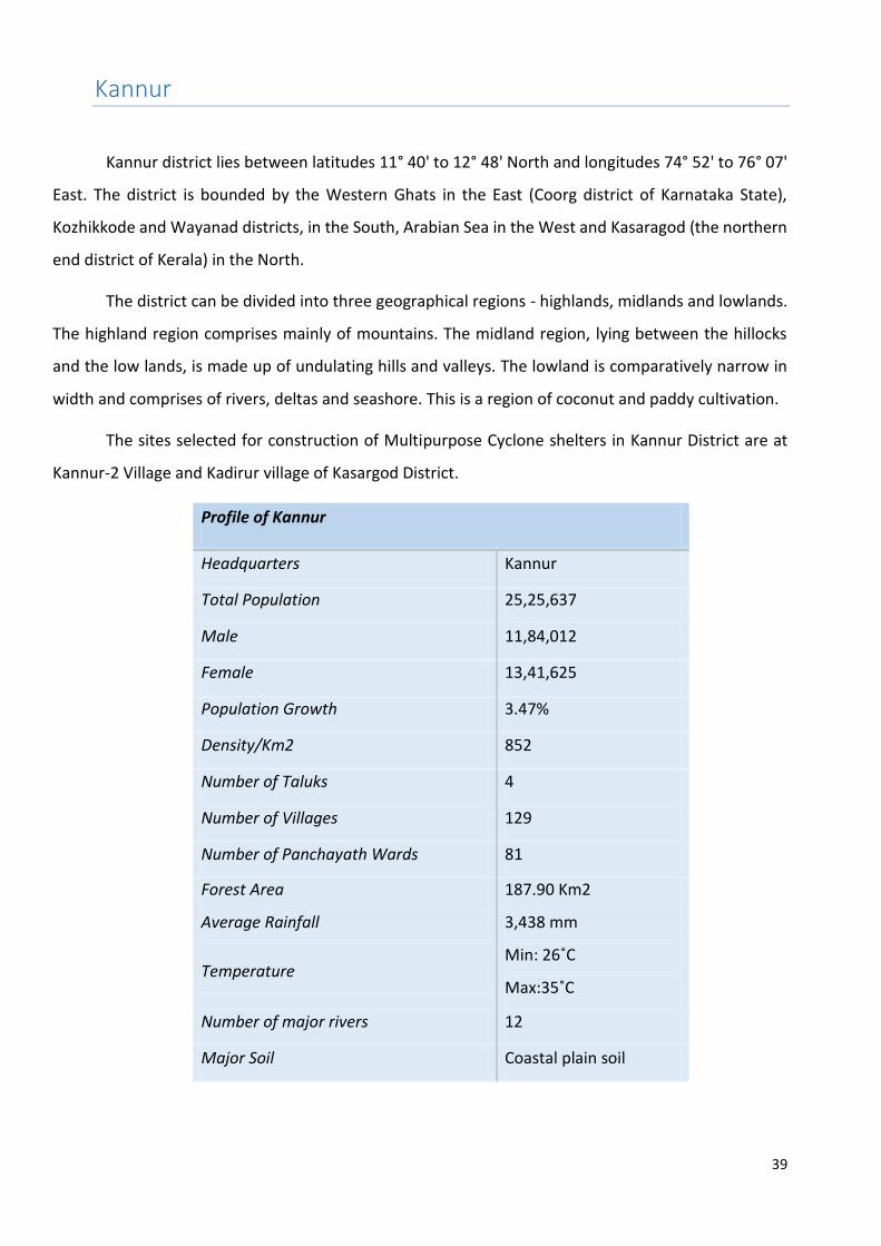
Kannur
Kannur district lies between latitudes 11° 40' to 12° 48' North and longitudes 74° 52' to 76° 07'
East. The district is bounded by the Western Ghats in the East (Coorg district of Karnataka State),
Kozhikkode and Wayanad districts, in the South, Arabian Sea in the West and Kasaragod (the northern
end district of Kerala) in the North.
The district can be divided into three geographical regions - highlands, midlands and lowlands.
The highland region comprises mainly of mountains. The midland region, lying between the hillocks
and the low lands, is made up of undulating hills and valleys. The lowland is comparatively narrow in
width and comprises of rivers, deltas and seashore. This is a region of coconut and paddy cultivation.
The sites selected for construction of Multipurpose Cyclone shelters in Kannur District are at
Kannur-2 Village and Kadirur village of Kasargod District.
Profile of Kannur
Headquarters Kannur
Total Population 25,25,637
Male 11,84,012
Female 13,41,625
Population Growth 3.47%
Density/Km2 852
Number of Taluks 4
Number of Villages 129
Number of Panchayath Wards 81
Forest Area 187.90 Km2
Average Rainfall 3,438 mm
Temperature Min: 26˚C
Max:35˚C
Number of major rivers 12
Major Soil Coastal plain soil

40
Vulnerability Assessment of the District
With a length of 110 Kms, the Valapattanam River, which originates from the Western
Ghats, is the longest river in the district. The main tributaries of the river are Valiapuzha and
Aralampuzha. The main other rivers in the district are passing through Kuppam, Mahe,
Anjarakkandy, Thalassery, Ramapuram and Perumba. The banks of these rivers are prone to
flooding during monsoon. Rough sea, high waves and coastal erosion are the major hurdles of
the community.
Taluks in the district
Flood
Coastal Erosion Storm surge/
Tsunami inundatio
n
Low High
With sea wall
Area km2
Area %
Length Km
Length %
Length Km Length % Area km2
Thaliparamba 116.4 8.8 2.6 29.3 - - 3.8
Kannur 116.2 26.7 13.3 31.5 3.8 8.9 22.5
Thalassery 106.2 8.8 1.4 10.1 5.6 39.2 4.8
Total 339.2 11.4 17.4 26.6 9.3 14.3 31.1
Source: National Centre for Earth Science Studie
41
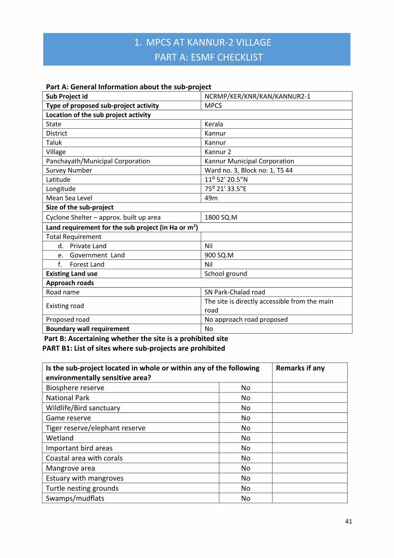
Part A: General Information about the sub-project Sub Project id NCRMP/KER/KNR/KAN/KANNUR2-1
Type of proposed sub-project activity MPCS
Location of the sub project activity
State Kerala
District Kannur
Taluk Kannur
Village Kannur 2
Panchayath/Municipal Corporation Kannur Municipal Corporation
Survey Number Ward no. 3, Block no: 1, TS 44
Latitude 11⁰ 52' 20.5”N
Longitude 75⁰ 21' 33.5"E
Mean Sea Level 49m
Size of the sub-project
Cyclone Shelter – approx. built up area 1800 SQ.M
Land requirement for the sub project (in Ha or m2)
Total Requirement
d. Private Land Nil
e. Government Land 900 SQ.M
f. Forest Land Nil
Existing Land use School ground
Approach roads
Road name SN Park-Chalad road
Existing road The site is directly accessible from the main road
Proposed road No approach road proposed
Boundary wall requirement No
Part B: Ascertaining whether the site is a prohibited site PART B1: List of sites where sub-projects are prohibited
Is the sub-project located in whole or within any of the following environmentally sensitive area?
Remarks if any
Biosphere reserve No
National Park No
Wildlife/Bird sanctuary No
Game reserve No
Tiger reserve/elephant reserve No
Wetland No
Important bird areas No
Coastal area with corals No
Mangrove area No
Estuary with mangroves No
Turtle nesting grounds No
Swamps/mudflats No
1. MPCS AT KANNUR-2 VILLAGE
PART A: ESMF CHECKLIST

42
Notified sensitive eco zone No
Is the sub-project located in whole or in part between the HTL and the LTL?
No
Is the sub-project located in whole or in part 200 meters from an estuary boundary?
No
Is the sub-project located in whole or in part 500 meters from flood plain or modified flood plain or by flood control systems of a riverine system?
No
Is the sub-project located in whole or in part 500 meters from railway line?
No Railway line is 670m from the site.
Is the sub-project located in whole or in part within 100 meters from the protected limits of notified archaeological sites or monuments?
No
Is the sub-project located in whole or in within 1km radius of:
Historic places that are regionally or locally important
No
Reservoirs/Dams No
Religious Places No
Public water bodies No
PART C: Environmental Screening Forms PART C1: Proximity to Coastal Regulatory Zone:
Is the sub-project located in whole or part within the Coastal Regulation Zone?
No Outside CRZ ( 0.70 km from HTL)
PART C2: Proximity to Environmentally Sensitive areas:
Not applicable as the construction area is less than 900 SQ.M.
PART C3: Environmental screening – outcome Screening outcome
Based on the updating of the screening results, the following clearances are required
CRZ clearance Not applicable
Environmental clearance Not applicable
Forest clearance Not applicable
PART D: Social Screening PART D1: Identification of potential social concerns
2. Does the proposed sub-project activity require any land? Remarks if any
Private Land No
Government Land Yes 900 SQ.M of land in Ownership of Education department

43
Part D (2): Result/Outcome of Social Screening Exercise Outcome
Social Impact Assessment is required No
Abbreviated RAP is required No
Full RAP is required No
Forest Land No
2. Does the proposed sub-project activity result in demolition/removal of existing structures?
No
Number of public structures/buildings No
Number of common property resources (such as religious/cultural/ drinking water/wells/etc)
No
Number of private structures (located on private or public land)
No
3. Does the proposed Project activity result in loss of crops/trees which is not Government property?
No
4. Does the proposed Project activity result in loss of direct livelihood/ employment?
No
5. Does the proposed activity result in loss of mangrove ecosystem/social forest on which nearby residents/local population are dependent for fuel wood/grazing etc.?
No
6. Does the proposed Project activity affect scheduled tribe/ caste communities?
No
Details of Screening Exercise
Name Mary Midhula Maxy
Designation Environmental and Social Specialist, State Project Implementation Unit, NCRMP-Kerala

44
PART B: BRIEF REPORT
Description of Environmental and Social features
The proposed Multipurpose Cyclone Shelter will be constructed in Kannur-2Village of Kannur Taluk
in Kannur District. The site is entitled to Education Department.
The site is located at a distance of 700 m from coastline and is 1 km away from Biosphere reserve,
National Park, Wildlife/Bird Sanctuary, Tiger or Elephant Reserves, Important Bird areas, Mangroves
Habitat of Migratory birds, Migratory route of Wild Animals/Birds, Reserved/Protected Forest, Zoological
Park, Botanical Garden. The site is not located within or at a distance of 1km from World Heritage Sites,
Archaeological monuments [under ASI’s Central/State list].
The site is located within the compound of town Higher Secondary School, Chalad. The site is part
of the playground and has playground equipment which will have to be relocated. A recently prepared jumping
pit was noted in the site. LBS centre for training is adjacent to the site. Construction of two classroom buildings
is in progress in the school premises. The school was used as relief camps earlier during heavy rains and
flooding.
Approach roads
The site is directly accessible from SN Road Chalad of 50m length and 8m ROW.
Demography of Kannu-2 Village
According to 2011 Census, the village has 11,418 households. The proposed Multipurpose Cyclone Shelter
is expected to benefit the Village Population during emergencies. The categories of population in the
village are given below in Table.
Table [Source: Census, 2011]
Population Persons
Total 56,823
Male 26,298
Female 30,525
In the age group 0-6 years 6,376
Scheduled Castes (SC) 2,674
Scheduled Tribes (ST) 159
Literates 48,536
Illiterate 8,287
Worker 15,324
Non Worker 41,499

45
Legal Clearances
Environmental Clearance
As per EIA notification, 2006 environmental clearance is mandatory for projects with built up area
more than 20,000 sq mt. Since, the built up area of Kannur 2 MPCS is only 1800 sq.mt, project does not
necessitate any Environmental clearance.
CRZ Clearance
Kannur 2 MPCS is 700 m from the High Tide Line and is not within the Coast Regulation Zone.
Hence, the project does not require clearance as per CRZ notification, 2011.
Forest Clearance
Since, diversion of forest area or felling of roadside plantation is not required during any phase of
construction of Kannur MPCS clearance as per Forest (Conservation) Act, 1980 is not applicable.

1. Aerial view of the site 2. View of the site
3. View of the site (Jumping pit can be seen) 4. School premises

47
GIS map of MPCS at Kannur 2 Village

PART C: PANCHAYATH RESOLUTION
District Kannur
Village Kannur
Panchayath Kannur Municipal Corporation
Place Kannur
Date 20.04.2016

49
Summary of the Panchayath meeting decision:
3. Kannur Municipal Corporation discussed on decision taken in Government Order: G.O (Rt) no.
641/2016/DMD dated 28.01.2016 to construct a Multi-Purpose Cyclone Shelter in Kannur 2
Village as informed through Letter no. M1/24797/14 dated 11.02.2016 from District
Administration, Kannur
4. Kannur Municipal Corporation in its resolution no E1/2815/16 (1) dated 26.02.2016 agrees
and accepts the decision of State Government to construct MPCS at Ward no. 3, Block no: 1,
TS 44, Town Higher Secondary School, Chalad. The Corporation does not see any adverse
environmental and social issues in construction of MPCS at the location.

50
Part A: General Information about the sub-project
Sub Project id NCRMP/KER/KNR/THA/KATHIRUR-1
Type of proposed sub-project activity MPCS
Location of the sub project activity
State Kerala
District Kannur
Taluk Thalassery
Village Kathirur
Panchayath/Municipal Corporation Kadirur Gramapanchayath
Survey Number Survey number: 89/3
Latitude 11⁰ 46' 24”N
Longitude 75⁰ 31' 24.1"E
Mean Sea Level 77 m
Size of the sub-project
Cyclone Shelter – approx. built up area 1000 SQ.M
Land requirement for the sub project (in Ha or m2)
Total Requirement
g. Private Land Nil
h. Government Land 600 SQ.M
i. Forest Land Nil
Existing Land use Barren land
Approach roads
Road name Thalassery Coorg road
Existing road 50m Length, 5m ROW
Proposed road No approach road proposed
Boundary wall requirement No
Part B: Ascertaining whether the site is a prohibited site PART B1: List of sites where sub-projects are prohibited
Is the sub-project located in whole or within any of the following environmentally sensitive area?
Remarks if any
Biosphere reserve No
National Park No
Wildlife/Bird sanctuary No
Game reserve No
Tiger reserve/elephant reserve No
Wetland No
Important bird areas No
Coastal area with corals No
Mangrove area No
Estuary with mangroves No
Turtle nesting grounds No
2. MPCS AT KATHIIRUR VILLAGE
PART A: ESMF CHECKLIST

51
Swamps/mudflats No
Notified sensitive eco zone No
Is the sub-project located in whole or in part between the HTL and the LTL?
No
Is the sub-project located in whole or in part 200 metres from an estuary boundary?
No
Is the sub-project located in whole or in part 500 meters from flood plain or modified flood plain or by flood control systems of a riverine system?
No
Is the sub-project located in whole or in part 500 meters from railway line?
No
Is the sub-project located in whole or in part within 100 meters from the protected limits of notified archaeological sites or monuments?
No
Is the sub-project located in whole or in within 1km radius of:
Historic places that are regionally or locally important
No
Reservoirs/Dams No
Religious Places No
Public water bodies No
PART C: Environmental Screening Forms PART C1: Proximity to Coastal Regulatory Zone:
Is the sub-project located in whole or part within the Coastal Regulation Zone?
No Outside CRZ ( 5 km from HTL)
PART C2: Proximity to Environmentally Sensitive areas:
Not applicable as the construction area is only 1000 SQ.M.
PART C3: Environmental screening – outcome Screening outcome
Based on the updating of the screening results, the following clearances are required
CRZ clearance Not applicable
Environmental clearance Not applicable
Forest clearance Not applicable
PART D: Social Screening PART D1: Identification of potential social concerns
Does the proposed sub-project activity require any land? Remarks if any
Private Land No
Government Land Yes Approximately 600 SQ.M of land under ownership of Revenue Department.
Forest Land No

52
Part D (2): Result/Outcome of Social Screening Exercise Outcome
Social Impact Assessment is required No
Abbreviated RAP is required No
Full RAP is required No
Details of Screening Exercise
Name Mary Midhula Maxy
Designation Environmental and Social Specialist, State Project Implementation Unit, NCRMP-Kerala
2. Does the proposed sub-project activity result in demolition/removal of existing structures?
No
Number of public structures/buildings No
Number of common property resources (such as religious/cultural/ drinking water/wells/etc)
No
Number of private structures (located on private or public land)
No
3. Does the proposed Project activity result in loss of crops/trees which is not Government property?
No
4. Does the proposed Project activity result in loss of direct livelihood/ employment?
No
5. Does the proposed activity result in loss of mangrove ecosystem/social forest on which nearby residents/local population are dependent for fuel wood/grazing etc.?
No
6. Does the proposed Project activity affect scheduled tribe/ caste communities?
No
PART B: BRIEF REPORT

53
Description of Environmental and Social features
The proposed Multipurpose Cyclone Shelter will be constructed in Kathirur Village of
Thalassery taluk in Kannur District. The site is entitled to Revenue Department.
The site is located at a distance of 5 km from coastline and is 1 km away from Biosphere
reserve, National Park, Wildlife/Bird Sanctuary, Tiger or Elephant Reserves, Important Bird areas,
Mangroves Habitat of Migratory birds, Migratory route of Wild Animals/Birds,
Reserved/Protected Forest, Zoological Park, Botanical Garden.
The site is not located within or at a distance of 1km from World Heritage Sites,
Archaeological monuments [under ASI’s Central/State list].
The site is a barren land and is used as playground at present. It was informed by the
Village Officer that the MPCS could be used as community halls as no such facility is available in
the village. A non-perennial stream is located to one corner of the site.
Approach roads
An approach road of 50m length and 5m ROW connects the site to Thalassery Koorg main
road.
Demography of Kathirur Village
According to 2011 Census, the village has 6817 households. The proposed Multipurpose Cyclone Shelter
is expected to benefit the Village Population during emergencies. The categories of population in the
village are given below in Table.
Table [Source: Census, 2011]
Population Persons
Total 31,087
Male 13,926
Female 17,161
In the age group 0-6 years 3,030
Scheduled Castes (SC) 366
Scheduled Tribes (ST) 75
Literates 27,403
Illiterate 3,684
Worker 9,381
Non Worker 21,706
Legal Clearances
Environmental Clearance
As per EIA notification, 2006 environmental clearance is mandatory for projects with built up area
more than 20,000 sq mt. Since, the built up area of Kathirur MPCS is only 1000 sq.mt, project does not
necessitate any Environmental clearance.

54
CRZ Clearance
Kathirur MPCS is 5 km from the High Tide Line and is not within the Coast Regulation Zone. Hence,
the project does not require clearance as per CRZ notification, 2011.
Forest Clearance
Since, diversion of forest area or felling of roadside plantation is not required during any phase
of construction of Kathirur MPCS clearance as per Forest (Conservation) Act, 1980 is not applicable.
2. Aerial view of the site 2. View of the site
3. Entry to the site 4. View of the site

GIS map of MPCS at Kathirur Village

57
District Kannur
Village Kathirur
Panchayath Kadirur Gramapanchayath
Place Kathirur
Date 25.02.2016
PART C: PANCHAYATH RESOLUTION

58
Summary of the Panchayath meeting decision:
5. Kadirur Gramapanchayath discussed on decision taken in Government Order: G.O (Rt) no.
641/2016/DMD dated 28.01.2016 on 28.01.2016 for constructing a Multi-Purpose Cyclone
Shelter in Kadirur Village.
6. The Panchayath in its resolution no. 21/16 dated 25/02/2016 agreed and accepted the
decision of the Government to construct a MPCS at Survey no: 89/3 of Kadirur Village.
7. The Panchayath in decision no. 37/16 (3) dated 31/05/2016 has informed the District
Collector Kasargod regarding the decision taken by Kadirur Gramapanchayath.
59
4. District: Kozhikode

60
Kozhikode District
The district of Kozhikode is 38.25% urban and is bordered by Kannur district to the North,
Wayanad to the East, and Malappuram to the South. To the West, lies the Arabian Sea. The
district is situated between latitudes 11° 08’N and 11° 50’N and longitudes 75°30’E and 76°8’E.
It has an elevation of 1 metre along the coast with the city's eastern edges rising to at
least 15 metres, with a sandy coastal belt and a lateritic midland. The district has a 80 km long
shoreline and small hills dot the terrain in the eastern and central regions.
The sites selected for construction of Multipurpose Cyclone shelters in Kozhikode District
are at Thikkodi Village and Kasaba village.
Profile of Kozhikode
Headquarters Kozhikode
Total Population 30,89,543
Male 14,73,028
Female 16,16,515
Population Growth 7.31%
Density/Km2 1318
Number of Taluks 4
Number of Villages 118
Number of Panchayath Wards 75
Forest Area 41386 Km2
Average Rainfall 3,200mm
Temperature Min: 22˚C
Max:39.4˚C
Number of major rivers 6
Major Soil Sandy soil and Laterite
soil

61
Vulnerability Assessment of the District
The banks of major rivers such as Mahe River, Murad (Kuttiady) river, Chaliyam River,
Kallai River are prone to flooding during monsoon. The table below details the vulnerability area
of the district to various hydro-meteorological hazards.
Taluks in
the
district
Flood Coastal Erosion Storm surge/
Tsunami inundation Low High
With sea wall
Area
km2
Area
%
Length
Km
Length
%
Length
Km
Length % Area
km2
Area %
Kozhikode 133.5 12.9 2.4 8.2 11.2 37.8 10.5 1.0
Quilandy 86.6 11.7 4.4 13.9 13.5 42.9 6.3 0.9
Vadakkara 67.8 11.8 1.7 10.4 10.7 67.0 2.1 0.4
Source: National Centre for Earth Science Studies
62
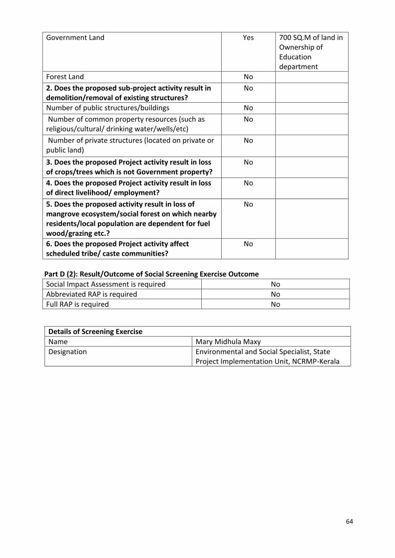
2. MPCS AT THIKKODI VILLAGE
PART A: ESMF CHECKLIST
Part A: General Information about the sub-project
Sub Project id NCRMP/KER/KZK/QUI/THIKKODI-2
Type of proposed sub-project activity MPCS
Location of the sub project activity
State Kerala
District kozhikode
Taluk Quilandy
Village Thikkodi
Panchayath/Municipal Corporation Thikkodi Gramapanchayath
Survey Number Survey number: 82/4C2
Latitude 11° 30’ 14.6”N
Longitude 75° 37’ 34.9”E
Mean Sea Level 13 m
Size of the sub-project
Cyclone Shelter – approx. built up area 12000 SQ.M
Land requirement for the sub project (in Ha or m2)
Total Requirement
g. Private Land Nil
h. Government Land 700 SQ.M
i. Forest Land Nil
Existing Land use Barren land, part of School ground
Approach roads
Road name The site is accessible from National highway
Existing road -
Proposed road No approach road proposed
Boundary wall requirement No
Part B: Ascertaining whether the site is a prohibited site PART B1: List of sites where sub-projects are prohibited
Is the sub-project located in whole or within any of the following environmentally sensitive area?
Remarks if any
Biosphere reserve No
National Park No
Wildlife/Bird sanctuary No
Game reserve No
Tiger reserve/elephant reserve No
Wetland No
Important bird areas No
Coastal area with corals No

63
Mangrove area No
Estuary with mangroves No
Turtle nesting grounds No
Swamps/mudflats No
Notified sensitive eco zone No
Is the sub-project located in whole or in part between the HTL and the LTL?
No
Is the sub-project located in whole or in part 200 meters from an estuary boundary?
No
Is the sub-project located in whole or in part 500 meters from flood plain or modified flood plain or by flood control systems of a riverine system?
No
Is the sub-project located in whole or in part 500 meters from railway line?
No Railway line is 300m from the site.
Is the sub-project located in whole or in part within 100 meters from the protected limits of notified archaeological sites or monuments?
No
Is the sub-project located in whole or in within 1km radius of:
Historic places that are regionally or locally important
No
Reservoirs/Dams No
Religious Places No
Public water bodies No
PART C: Environmental Screening Forms PART C1: Proximity to Coastal Regulatory Zone:
Is the sub-project located in whole or part within the Coastal Regulation Zone?
No Outside CRZ ( 1.5 km from HTL)
PART C2: Proximity to Environmentally Sensitive areas:
Not applicable as the construction area is less than 700 SQ.M.
PART C3: Environmental screening – outcome Screening outcome
Based on the updating of the screening results, the following clearances are required
CRZ clearance Not applicable
Environmental clearance Not applicable
Forest clearance Not applicable
PART D: Social Screening PART D1: Identification of potential social concerns
3. Does the proposed sub-project activity require any land? Remarks if any
Private Land No
64
Part D (2): Result/Outcome of Social Screening Exercise Outcome
Social Impact Assessment is required No
Abbreviated RAP is required No
Full RAP is required No
Government Land Yes 700 SQ.M of land in Ownership of Education department
Forest Land No
2. Does the proposed sub-project activity result in demolition/removal of existing structures?
No
Number of public structures/buildings No
Number of common property resources (such as religious/cultural/ drinking water/wells/etc)
No
Number of private structures (located on private or public land)
No
3. Does the proposed Project activity result in loss of crops/trees which is not Government property?
No
4. Does the proposed Project activity result in loss of direct livelihood/ employment?
No
5. Does the proposed activity result in loss of mangrove ecosystem/social forest on which nearby residents/local population are dependent for fuel wood/grazing etc.?
No
6. Does the proposed Project activity affect scheduled tribe/ caste communities?
No
Details of Screening Exercise
Name Mary Midhula Maxy
Designation Environmental and Social Specialist, State Project Implementation Unit, NCRMP-Kerala
65
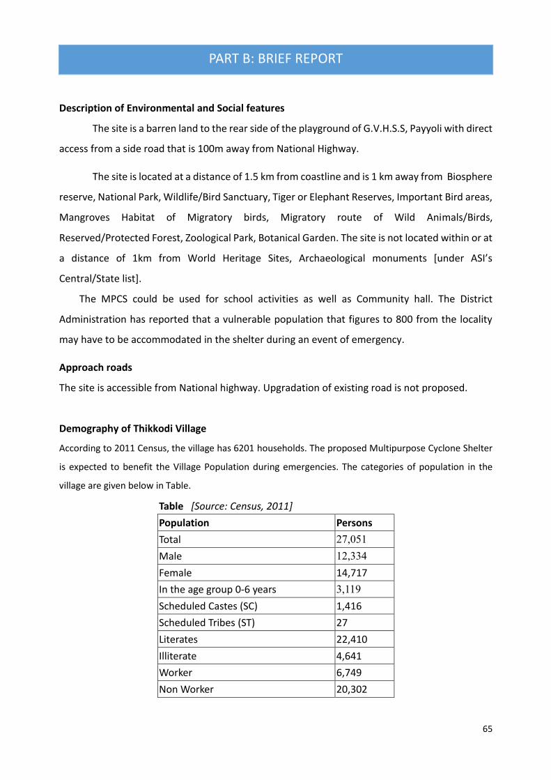
PART B: BRIEF REPORT
Description of Environmental and Social features
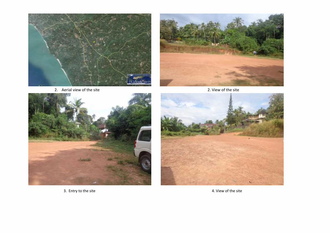
The site is a barren land to the rear side of the playground of G.V.H.S.S, Payyoli with direct
access from a side road that is 100m away from National Highway.
The site is located at a distance of 1.5 km from coastline and is 1 km away from Biosphere
reserve, National Park, Wildlife/Bird Sanctuary, Tiger or Elephant Reserves, Important Bird areas,
Mangroves Habitat of Migratory birds, Migratory route of Wild Animals/Birds,
Reserved/Protected Forest, Zoological Park, Botanical Garden. The site is not located within or at
a distance of 1km from World Heritage Sites, Archaeological monuments [under ASI’s
Central/State list].
The MPCS could be used for school activities as well as Community hall. The District
Administration has reported that a vulnerable population that figures to 800 from the locality
may have to be accommodated in the shelter during an event of emergency.
Approach roads
The site is accessible from National highway. Upgradation of existing road is not proposed.
Demography of Thikkodi Village
According to 2011 Census, the village has 6201 households. The proposed Multipurpose Cyclone Shelter
is expected to benefit the Village Population during emergencies. The categories of population in the
village are given below in Table.
Table [Source: Census, 2011]
Population Persons
Total 27,051
Male 12,334
Female 14,717
In the age group 0-6 years 3,119
Scheduled Castes (SC) 1,416
Scheduled Tribes (ST) 27
Literates 22,410
Illiterate 4,641
Worker 6,749
Non Worker 20,302
66
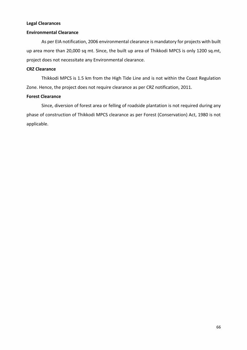
Legal Clearances
Environmental Clearance
As per EIA notification, 2006 environmental clearance is mandatory for projects with built
up area more than 20,000 sq mt. Since, the built up area of Thikkodi MPCS is only 1200 sq.mt,
project does not necessitate any Environmental clearance.
CRZ Clearance
Thikkodi MPCS is 1.5 km from the High Tide Line and is not within the Coast Regulation
Zone. Hence, the project does not require clearance as per CRZ notification, 2011.
Forest Clearance
Since, diversion of forest area or felling of roadside plantation is not required during any
phase of construction of Thikkodi MPCS clearance as per Forest (Conservation) Act, 1980 is not
applicable.

1. Aerial view of the site 2. View of the site
3. View from approach road 4. View of the site

68
GIS map of MPCS at Thikkodi Village

PART C: PANCHAYATH RESOLUTION
District Kozhikode
Village Thikkodi
Panchayath Thikkodi Gramapanchayath
Place Thikkodi
Date 20.04.2016

70
Summary of the Panchayath meeting decision:
5. Kozhikode District panchayath discussed on decision taken in Government Order: G.O
(Rt) no. 641/2016/DMD dated 28.01.2016 to construct a Multi-Purpose Cyclone
Shelter in the compound of G.V.H.S.S Payyoli, Survey no: 82/4C2 of Thikkodi Village.
6. The Panchayath sees no environmental or social impacts in constructing the MPCS at
the site.
7. The Panchayath in its resolution no: 9/16(2) (d) agreed and accepted the decision to
construct MPCS in the site.
71
Part A: General Information about the sub-project
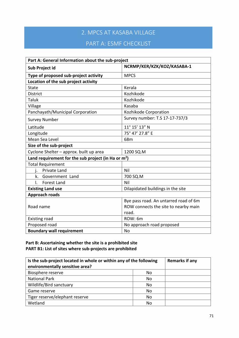
Sub Project id NCRMP/KER/KZK/KOZ/KASABA-1
Type of proposed sub-project activity MPCS
Location of the sub project activity
State Kerala
District Kozhikode
Taluk Kozhikode
Village Kasaba
Panchayath/Municipal Corporation Kozhikode Corporation
Survey Number Survey number: T.S 17-17-737/3
Latitude 11° 15’ 13” N
Longitude 75° 47’ 27.8” E
Mean Sea Level 68m
Size of the sub-project
Cyclone Shelter – approx. built up area 1200 SQ.M
Land requirement for the sub project (in Ha or m2)
Total Requirement
j. Private Land Nil
k. Government Land 700 SQ.M
l. Forest Land Nil
Existing Land use Dilapidated buildings in the site
Approach roads
Road name Bye pass road. An untarred road of 6m ROW connects the site to nearby main road.
Existing road ROW: 6m
Proposed road No approach road proposed
Boundary wall requirement No
Part B: Ascertaining whether the site is a prohibited site PART B1: List of sites where sub-projects are prohibited
Is the sub-project located in whole or within any of the following environmentally sensitive area?
Remarks if any
Biosphere reserve No
National Park No
Wildlife/Bird sanctuary No
Game reserve No
Tiger reserve/elephant reserve No
Wetland No
2. MPCS AT KASABA VILLAGE
PART A: ESMF CHECKLIST

72
Important bird areas No
Coastal area with corals No
Mangrove area No
Estuary with mangroves No
Turtle nesting grounds No
Swamps/mudflats No
Notified sensitive eco zone No
Is the sub-project located in whole or in part between the HTL and the LTL?
No
Is the sub-project located in whole or in part 200 metres from an estuary boundary?
No
Is the sub-project located in whole or in part 500 meters from flood plain or modified flood plain or by flood control systems of a riverine system?
No
Is the sub-project located in whole or in part 500 meters from railway line?
No The site is 1.3 km from railway
Is the sub-project located in whole or in part within 100 meters from the protected limits of notified archaeological sites or monuments?
No
Is the sub-project located in whole or in within 1km radius of:
Historic places that are regionally or locally important
No
Reservoirs/Dams No
Religious Places No
Public water bodies No
PART C: Environmental Screening Forms PART C1: Proximity to Coastal Regulatory Zone:
Is the sub-project located in whole or part within the Coastal Regulation Zone?
No Outside CRZ ( 2 km from HTL)
PART C2: Proximity to Environmentally Sensitive areas:
Not applicable as the construction area is only 1200 SQ.M.
PART C3: Environmental screening – outcome Screening outcome
Based on the updating of the screening results, the following clearances are required
CRZ clearance Not applicable
Environmental clearance Not applicable
Forest clearance Not applicable
PART D: Social Screening PART D1: Identification of potential social concerns
Does the proposed sub-project activity require any land? Remarks if any

73
Part D (2): Result/Outcome of Social Screening Exercise Outcome
Social Impact Assessment is required No
Abbreviated RAP is required No
Full RAP is required No
Details of Screening Exercise
Name Mary Midhula Maxy
Designation Environmental and Social Specialist, State Project Implementation Unit, NCRMP-Kerala
Private Land No
Government Land Yes Approximately 700 SQ.M of land under ownership of Revenue Department.
Forest Land No
2. Does the proposed sub-project activity result in demolition/removal of existing structures?
No
Number of public structures/buildings Yes 2 (Two) Two dilapidated Disaster Shelters exists in the site which has to be
demolished for site clearance.
Number of common property resources (such as religious/cultural/ drinking water/wells/etc)
No
Number of private structures (located on private or public land)
No
3. Does the proposed Project activity result in loss of crops/trees which is not Government property?
No
4. Does the proposed Project activity result in loss of direct livelihood/ employment?
No
5. Does the proposed activity result in loss of mangrove ecosystem/social forest on which nearby residents/local population are dependent for fuel wood/grazing etc.?
No
6. Does the proposed Project activity affect scheduled tribe/ caste communities?
No
PART B: BRIEF REPORT

74
Description of Environmental and Social features
The site is within the Taluk Office compound of Kozhikode. Two dilapidated disaster shelters
has to be demolished to facilitate new construction. A dilapidated survey school building exist in
close proximity to the dilapidated buildings. The dilapidated buildings are being used as store
houses for obsolete election materials which has to be disposed of by the Revenue authorities.
Branches of some trees has to be cut to facilitate construction.
The site is located at a distance of 2 km from coastline and is 1 km away from Biosphere
reserve, National Park, Wildlife/Bird Sanctuary, Tiger or Elephant Reserves, Important Bird areas,
Mangroves Habitat of Migratory birds, Migratory route of Wild Animals/Birds,
Reserved/Protected Forest, Zoological Park, Botanical Garden.
The site is not located within or at a distance of 1km from World Heritage Sites,
Archaeological monuments [under ASI’s Central/State list].
The MPCS could be used for various purposes of the District Administration as well as
training for Survey staff. The District Administration has reported that a vulnerable population
that figures to 2800 from the locality may have to be accommodated in the shelter during an
even of emergency.
Approach roads
An untarred road of 6m ROW connects the site to nearby main road. Upgradation of existing
approach road is not proposed.
Demography of Kasaba Village
According to 2011 Census, the village has 2468 households. The proposed Multipurpose Cyclone Shelter
is expected to benefit the Village Population during emergencies. The categories of population in the
village are given below in Table.
Table [Source: Census, 2011]
Population Persons
Total 10,717
Male 5,283
Female 5,434
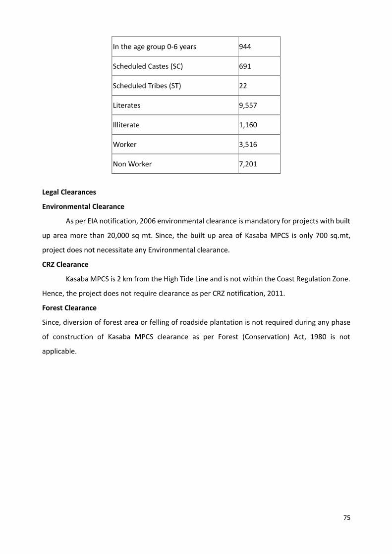
75
Legal Clearances
Environmental Clearance
As per EIA notification, 2006 environmental clearance is mandatory for projects with built
up area more than 20,000 sq mt. Since, the built up area of Kasaba MPCS is only 700 sq.mt,
project does not necessitate any Environmental clearance.
CRZ Clearance
Kasaba MPCS is 2 km from the High Tide Line and is not within the Coast Regulation Zone.
Hence, the project does not require clearance as per CRZ notification, 2011.
Forest Clearance
Since, diversion of forest area or felling of roadside plantation is not required during any phase
of construction of Kasaba MPCS clearance as per Forest (Conservation) Act, 1980 is not
applicable.
In the age group 0-6 years 944
Scheduled Castes (SC) 691
Scheduled Tribes (ST) 22
Literates 9,557
Illiterate 1,160
Worker 3,516
Non Worker 7,201
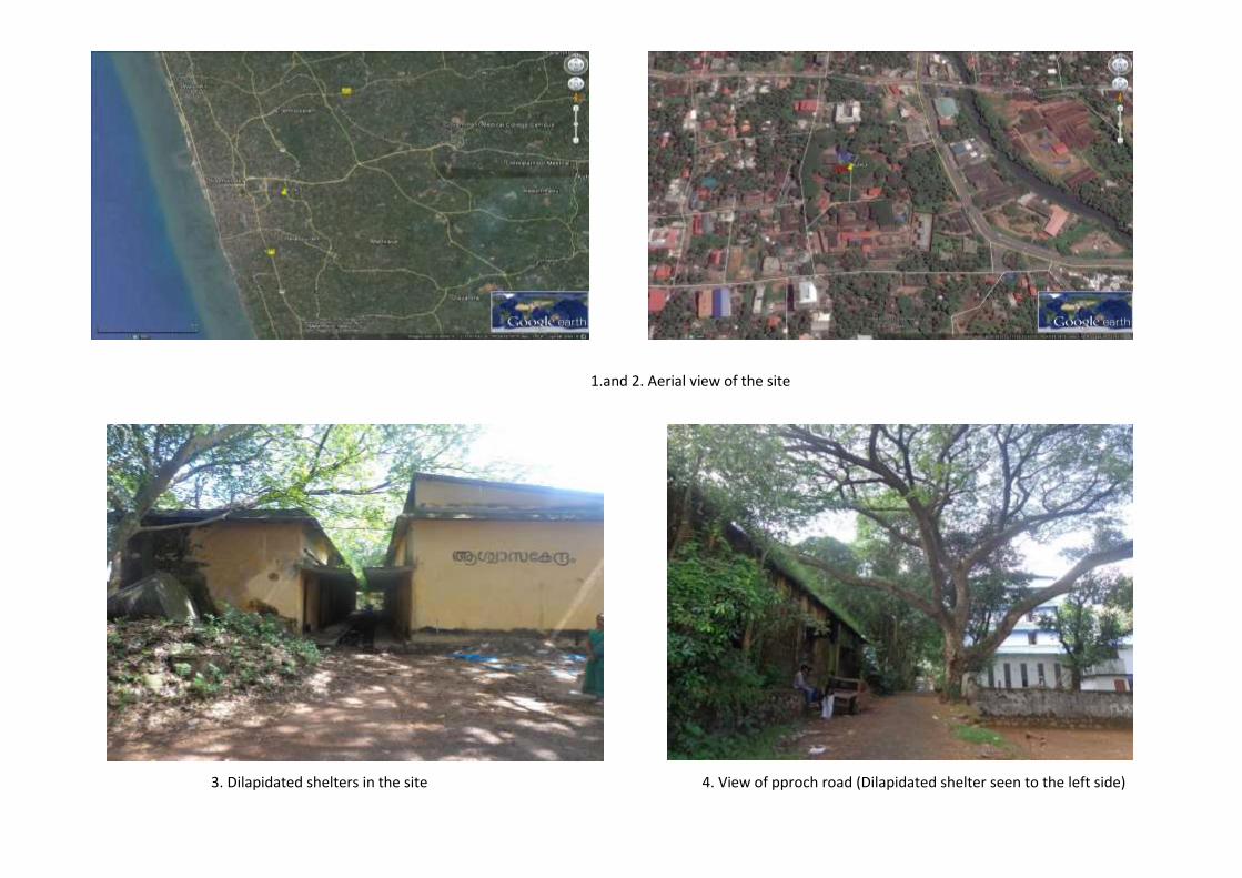
1.and 2. Aerial view of the site
3. Dilapidated shelters in the site 4. View of pproch road (Dilapidated shelter seen to the left side)

GIS map of MPCS at Kasaba Village

Summary of the Panchayath meeting decision:
District Kozhikode
Village Kasaba
Panchayath Kozhikode Corporation
Place Kasaba
Date
PART C: PANCHAYATH RESOLUTION

79
5.District: Malappuram
80
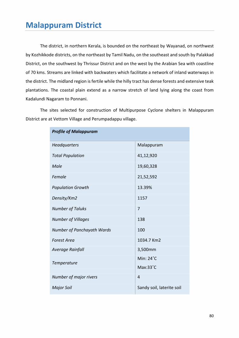
Malappuram District
The district, in northern Kerala, is bounded on the northeast by Wayanad, on northwest
by Kozhikkode districts, on the northeast by Tamil Nadu, on the southeast and south by Palakkad
District, on the southwest by Thrissur District and on the west by the Arabian Sea with coastline
of 70 kms. Streams are linked with backwaters which facilitate a network of inland waterways in
the district. The midland region is fertile while the hilly tract has dense forests and extensive teak
plantations. The coastal plain extend as a narrow stretch of land lying along the coast from
Kadalundi Nagaram to Ponnani.
The sites selected for construction of Multipurpose Cyclone shelters in Malappuram
District are at Vettom Village and Perumpadappu village.
Profile of Malappuram
Headquarters Malappuram
Total Population 41,12,920
Male 19,60,328
Female 21,52,592
Population Growth 13.39%
Density/Km2 1157
Number of Taluks 7
Number of Villages 138
Number of Panchayath Wards 100
Forest Area 1034.7 Km2
Average Rainfall 3,500mm
Temperature Min: 24˚C
Max:33˚C
Number of major rivers 4
Major Soil Sandy soil, laterite soil

81
Vulnerability Assessment of the District
The banks of major rivers Chaliyar, Kadalundi, Purapparamba, Tirur
and Bharathapuzha prone to flooding during monsoon. The table below details the vulnerability
area of the district to various hydro-meteorological hazards.
Taluks in the
district
Flood Coastal Erosion Storm surge/
Tsunami
inundation Low High
With sea wall
Area
km2
Area
%
Length
Km
Length
%
Length Km Length
%
Area km2 Area
%
Ponnani 80.1 40.2 5.2 43.5 4.3 36.1 7.5 3.8
Tirur 109.6 24.4 - - 1.0 4.0 10.3 2.3
Tirurangadi 78.7 24.1 1.2 9.7 10.0 80.9 2.9 0.9
Eranad 100.7 14.4 - - - - - -
Perinthalmanna 81.2 16.1 - - - - - -
Nilambur 151.3 11.0 - - - - - -
Source: National Centre for Earth Science Studies

82
3. MPCS AT VETTTOM VILLAGE
PART A: ESMF CHECKLIST
Part A: General Information about the sub-project
Sub Project id NCRMP/KER/MPM/TIR/VETTOM-1
Type of proposed sub-project activity MPCS
Location of the sub project activity
State Kerala
District Malappuram
Taluk Tirur
Village Vettom
Panchayath/Municipal Corporation Vettom Gramapanchayath
Survey Number Survey number: 23/6
Latitude 10⁰ 54' 1.6”N
Longitude 75⁰ 53' 32.4"E
Mean Sea Level 12 m
Size of the sub-project
Cyclone Shelter – approx. built up area 1200 SQ.M
Land requirement for the sub project (in Ha or m2)
Total Requirement
j. Private Land Nil
k. Government Land 600 SQ.M
l. Forest Land Nil
Existing Land use Barren land, School ground
Approach roads
Road name Tippu Sulthan Road
Existing road 12m ROW
Proposed road No approach road proposed
Boundary wall requirement No
Part B: Ascertaining whether the site is a prohibited site PART B1: List of sites where sub-projects are prohibited
Is the sub-project located in whole or within any of the following environmentally sensitive area?
Remarks if any
Biosphere reserve No
National Park No
Wildlife/Bird sanctuary No
Game reserve No
Tiger reserve/elephant reserve No
Wetland No
Important bird areas No
Coastal area with corals No
Mangrove area No
83
Estuary with mangroves No
Turtle nesting grounds No
Swamps/mudflats No
Notified sensitive eco zone No
Is the sub-project located in whole or in part between the HTL and the LTL?
No
Is the sub-project located in whole or in part 200 meters from an estuary boundary?
No
Is the sub-project located in whole or in part 500 meters from flood plain or modified flood plain or by flood control systems of a riverine system?
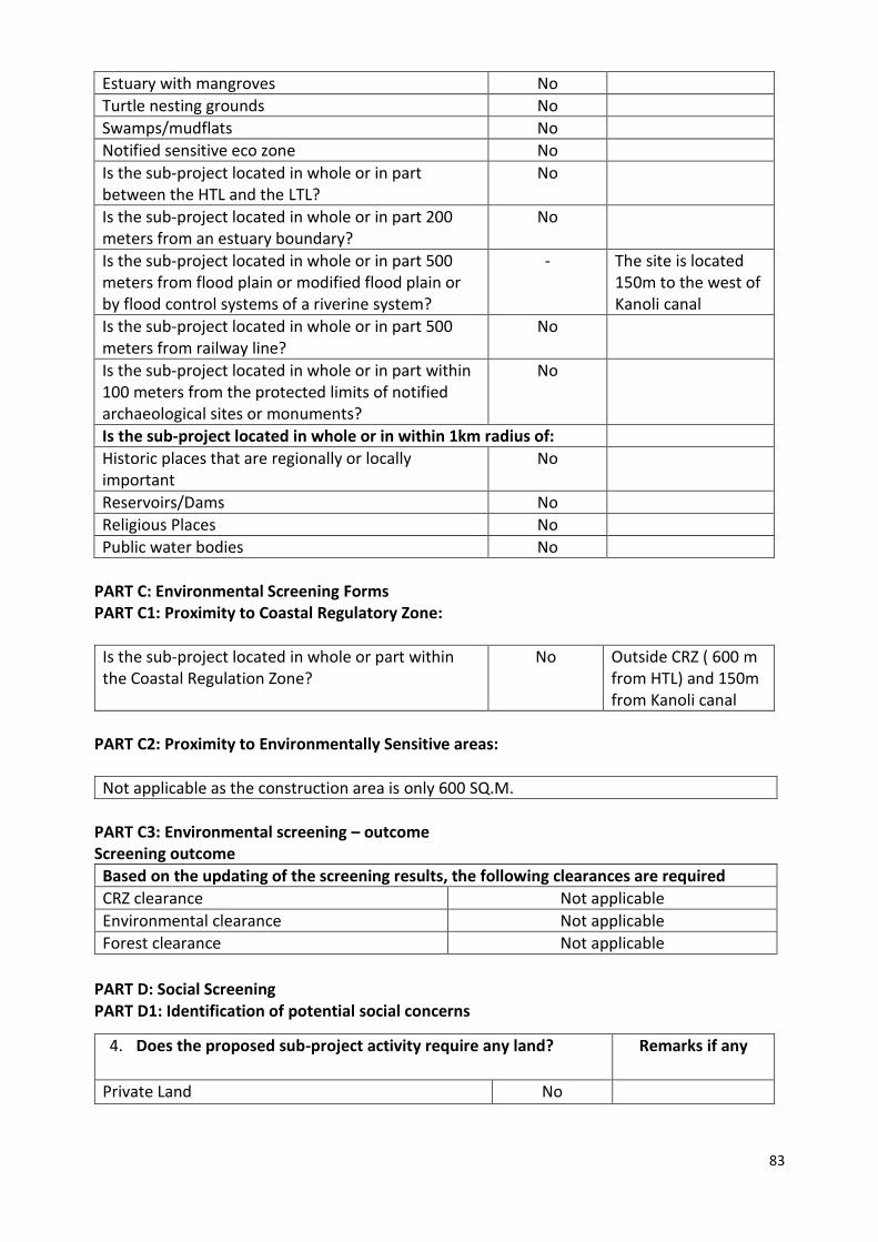
-
The site is located 150m to the west of Kanoli canal
Is the sub-project located in whole or in part 500 meters from railway line?
No
Is the sub-project located in whole or in part within 100 meters from the protected limits of notified archaeological sites or monuments?
No
Is the sub-project located in whole or in within 1km radius of:
Historic places that are regionally or locally important
No
Reservoirs/Dams No
Religious Places No
Public water bodies No
PART C: Environmental Screening Forms PART C1: Proximity to Coastal Regulatory Zone:
Is the sub-project located in whole or part within the Coastal Regulation Zone?
No Outside CRZ ( 600 m from HTL) and 150m from Kanoli canal
PART C2: Proximity to Environmentally Sensitive areas:
Not applicable as the construction area is only 600 SQ.M.
PART C3: Environmental screening – outcome Screening outcome
Based on the updating of the screening results, the following clearances are required
CRZ clearance Not applicable
Environmental clearance Not applicable
Forest clearance Not applicable
PART D: Social Screening PART D1: Identification of potential social concerns
4. Does the proposed sub-project activity require any land? Remarks if any
Private Land No

84
Part D (2): Result/Outcome of Social Screening Exercise Outcome
Social Impact Assessment is required No
Abbreviated RAP is required No
Full RAP is required No
Government Land Yes 600 SQ.M of land in Ownership of Education department
Forest Land No
2. Does the proposed sub-project activity result in demolition/removal of existing structures?
No
Number of public structures/buildings No
Number of common property resources (such as religious/cultural/ drinking water/wells/etc)
No
Number of private structures (located on private or public land)
No
3. Does the proposed Project activity result in loss of crops/trees which is not Government property?
No
4. Does the proposed Project activity result in loss of direct livelihood/ employment?
No
5. Does the proposed activity result in loss of mangrove ecosystem/social forest on which nearby residents/local population are dependent for fuel wood/grazing etc.?
No
6. Does the proposed Project activity affect scheduled tribe/ caste communities?
No
Details of Screening Exercise
Name Mary Midhula Maxy
Designation Environmental and Social Specialist, State Project Implementation Unit, NCRMP-Kerala

85
PART B: BRIEF REPORT
Description of Environmental and Social feature
The proposed site is within the premises of Government Mappila Upper Primary School,
Pavaranna which extends to 2.5acres of land. The school was earlier used as relief camps during
events of heavy rain and floods. The MPCS could be used for school activities during peace time.
The school has student strength of 978 students with possibility of upgradation to High school.
An Anganwadi functions near to the site. A tree is located in the site, construction has to be
planned in such as to avoid felling the tree. The site is in close proximity to vulnerable population.
The site is accessible from the nearby main road and has access to all basic amenities such as
water and power supply.
The site is located at a distance of 2 km from coastline and is 1 km away from Biosphere
reserve, National Park, Wildlife/Bird Sanctuary, Tiger or Elephant Reserves, Important Bird areas,
Mangroves Habitat of Migratory birds, Migratory route of Wild Animals/Birds,
Reserved/Protected Forest, Zoological Park, Botanical Garden. The site is not located within or at
a distance of 1km from World Heritage Sites, Archaeological monuments [under ASI’s
Central/State list]. The site is located 150m to the west of Kanoli canal.
Approach roads
The site is accessible from Tippu Sulthan road which is 12m in ROW. Upgradation of existing
approach road is not proposed.
Demography of Vettom Village
According to 2011 Census, the village has 6577 households. The proposed Multipurpose Cyclone
Shelter is expected to benefit the Village Population during emergencies. The categories of population in
the village are given below in Table.
Table [Source: Census, 2011]
Population Persons
Total 37,456
Male 17,401

86
Legal Clearances
Environmental Clearance
As per EIA notification, 2006 environmental clearance is mandatory for projects with built
up area more than 20,000 sq mt. Since, the built up area of Vettom MPCS is only 1200 sq.mt,
project does not necessitate any Environmental clearance.
CRZ Clearance
Vettom MPCS is 2 km from the High Tide Line and is not within the Coast Regulation Zone.
Hence, the project does not require clearance as per CRZ notification, 2011.
Forest Clearance
Since, diversion of forest area or felling of roadside plantation is not required during any
phase of construction of Vettom MPCS clearance as per Forest (Conservation) Act, 1980 is not
applicable.
Female 20,055
In the age group 0-6 years 5,081
Scheduled Castes (SC) 1,367
Scheduled Tribes (ST) 57
Literates 29,816
Illiterate 7,640
Worker 9,421
Non Worker 28,035

1. Aerial view of the site 2. View of the site
3. Tree located in the site 4. School premises and school ground

88
GIS map of MPCS at Vettom Village

PART C: PANCHAYATH RESOLUTION
District Malappuram
Village Vettom
Panchayath Vettom Gramapanchayath
Place Vettom
Date 20.04.2016
90

91
Summary of the Panchayath meeting decision:
8. Vettom Gramapanchayath discussed on decision taken in Government Order: G.O
(Rt) no. 641/2016/DMD dated 28.01.2016 to construct a Multi-Purpose Cyclone
Shelter in the compound of G.M.U.P.S, Paravanna of Vettom Village as informed
from District Administration
9. Vettom Gramapanchayath in its resolution no III (2) dated 27.02.106 considered the
decision taken in the Works Standing committee meeting held on 23.02.2016 and
has agreed and accepted the decisions of the state Government vide G.O (Rt) no.
641/2016/DMD dated 28.01.2016 to construct a Multi-Purpose Cyclone Shelter in
the compound of G.M.U.P.S, Paravanna of Vettom Village.
10. Vettom Gramapanchayath does not see any adverse environmental or social
consequences in constructing the MPCS at the site.

92
Part A: General Information about the sub-project
Sub Project id NCRMP/KER/MPM/PON/PERUMPADAPPU-1
Type of proposed sub-project activity MPCS
Location of the sub project activity
State Kerala
District Malappuram
Taluk Ponnani
Village Perumpadappu
Panchayath/Municipal Corporation Perumpadappu Gramapanchayath
Survey Number Survey number: 108/7
Latitude 10⁰ 42' 6.1”N
Longitude 75⁰ 57' 29.6"E
Mean Sea Level 10 m
Size of the sub-project
Cyclone Shelter – approx. built up area 1000 SQ.M
Land requirement for the sub project (in Ha or m2)
Total Requirement
m. Private Land Nil
n. Government Land 600 SQ.M
o. Forest Land Nil
Existing Land use Barren land
Approach roads
Road name National Highway
Existing road -
Proposed road No approach road proposed
Boundary wall requirement No
Part B: Ascertaining whether the site is a prohibited site PART B1: List of sites where sub-projects are prohibited
Is the sub-project located in whole or within any of the following environmentally sensitive area?
Remarks if any
Biosphere reserve No
National Park No
Wildlife/Bird sanctuary No
Game reserve No
Tiger reserve/elephant reserve No
Wetland No Paddy field are found within 1km radius of the site
Important bird areas No
Coastal area with corals No
Mangrove area No
Estuary with mangroves No
2. MPCS AT PERUMPADAPPU VILLAGE
PART A: ESMF CHECKLIST
Part A: General Information about the sub-project
Sub Project id NCRMP/KER/KSD/ HOS/PULLUR -1
Type of proposed sub-project activity MPCS
Location of the sub project activity
State Kerala
District Kasargod
Taluk Hosdurg
Village Pullur
Panchayath/Municipal Corporation Pullur-Periya Gramapanchayath
Survey Number Survey number: 110/1A3A
Latitude 12⁰ 21' 28.2”N
Longitude 75⁰ 6' 1.4"E
Mean Sea Level 49m
Size of the sub-project
Cyclone Shelter – approx. built up area
Land requirement for the sub project (in Ha or m2)
Total Requirement
a. Private Land Nil
b. Government Land 1300 SQ.M
c. Forest Land Nil
Existing Land use Barren land
Approach roads
Road name Pullur-Pannikunnu road (Haripuram Mengoth Kodavalam Road)
Existing road ROW: 8m
Proposed road No approach road proposed.
Boundary wall requirement No
2. MPCS AT PULLUR VILLAGE
PART A: ESMF CHECKLIST

93
Turtle nesting grounds No
Swamps/mudflats No
Notified sensitive eco zone No
Is the sub-project located in whole or in part between the HTL and the LTL?
No
Is the sub-project located in whole or in part 200 metres from an estuary boundary?
No
Is the sub-project located in whole or in part 500 meters from flood plain or modified flood plain or by flood control systems of a riverine system?
No
Is the sub-project located in whole or in part 500 meters from railway line?
No
Is the sub-project located in whole or in part within 100 meters from the protected limits of notified archaeological sites or monuments?
No
Is the sub-project located in whole or in within 1km radius of:
Historic places that are regionally or locally important
No
Reservoirs/Dams No
Religious Places No
Public water bodies No
PART C: Environmental Screening Forms PART C1: Proximity to Coastal Regulatory Zone:
Is the sub-project located in whole or part within the Coastal Regulation Zone?
No Outside CRZ ( 750 m from HTL)
PART C2: Proximity to Environmentally Sensitive areas:
Not applicable as the construction area is only 1000 SQ.M.
PART C3: Environmental screening – outcome Screening outcome
Based on the updating of the screening results, the following clearances are required
CRZ clearance Not applicable
Environmental clearance Not applicable
Forest clearance Not applicable
PART D: Social Screening PART D1: Identification of potential social concerns
Does the proposed sub-project activity require any land? Remarks if any
Private Land No
Government Land Yes Approximately 600 SQ.M of land under

94
Part D (2): Result/Outcome of Social Screening Exercise Outcome
Social Impact Assessment is required No
Abbreviated RAP is required No
Full RAP is required No
Details of Screening Exercise
Name Mary Midhula Maxy
Designation Environmental and Social Specialist, State Project Implementation Unit, NCRMP-Kerala
ownership of Education Department.
Forest Land No
2. Does the proposed sub-project activity result in demolition/removal of existing structures?
No
Number of public structures/buildings No
Number of common property resources (such as religious/cultural/ drinking water/wells/etc)
No
Number of private structures (located on private or public land)
No
3. Does the proposed Project activity result in loss of crops/trees which is not Government property?
No
4. Does the proposed Project activity result in loss of direct livelihood/ employment?
No
5. Does the proposed activity result in loss of mangrove ecosystem/social forest on which nearby residents/local population are dependent for fuel wood/grazing etc.?
No
6. Does the proposed Project activity affect scheduled tribe/ caste communities?
No

95
Description of Environmental and Social features
The site is within the premises of G.H.S.S, Palappetty of Perumpadappu village and is
positioned towards one corner of the school playground. Construction without encroaching the
playground has to be ensured. The school has student strength of 900. A toilet building is
positioned adjacent to the proposed site. The school was used as relief camp five years back. The
MPCS could be used for school related activities. A campus planning has to be done to ensure
that the MPCS is oriented in a manner that will not lead to loss of school playground.
The site is located at a distance of 750 m from coastline and is 1 km away from Biosphere
reserve, National Park, Wildlife/Bird Sanctuary, Tiger or Elephant Reserves, Important Bird areas,
Mangroves Habitat of Migratory birds, Migratory route of Wild Animals/Birds,
Reserved/Protected Forest, Zoological Park, Botanical Garden. Paddy fields are found within 1
km radius of the site.
The site is not located within or at a distance of 1km from World Heritage Sites,
Archaeological monuments [under ASI’s Central/State list].
Approach roads
The site is directly accessible from National Highway. Upgradation of existing approach
road is not proposed.
Demography of Perumpadappu Village
According to 2011 Census, the village has 5876 households. The proposed Multipurpose Cyclone
Shelter is expected to benefit the Village Population during emergencies. The categories of
population in the village are given below in Table.
Table [Source: Census, 2011]
Population Persons
Total 29,766
Male 13,553
Female 16,213
In the age group 0-6 years 3,937
Scheduled Castes (SC) 321
Scheduled Tribes (ST) 28
Literates 23,858
PART B: BRIEF REPORT
PART B: BRIEF REPORT

96
Illiterate 5,908
Worker 6,709
Non Worker 23,057
Legal Clearances
Environmental Clearance
As per EIA notification, 2006 environmental clearance is mandatory for projects with built
up area more than 20,000 sq mt. Since, the built up area of Perumpadappu MPCS is only 1000
sq.mt, project does not necessitate any Environmental clearance.
CRZ Clearance
Perumpadappu MPCS is 700 m from the High Tide Line and is not within the Coast
Regulation Zone. Hence, the project does not require clearance as per CRZ notification, 2011.
Forest Clearance
Since, diversion of forest area or felling of roadside plantation is not required during any
phase of construction of Perumpadappu MPCS clearance as per Forest (Conservation) Act, 1980
is not applicable.

3. Aerial view of the site 2. View of the site (School building can be seen)
3 and 4.View of the site

GIS map of MPCS at Perumpadappu Village

99
District Malappuram
Village Perumpadappu
Panchayath Perumpadappu Gramapanchayath
Place Perumpadappu
Date 26.02.2016
PART C: PANCHAYATH RESOLUTION
PART C: PANCHAYATH RESOLUTION
100
Summary of the Panchayath meeting decision:
1. Perumpadappu Gramapanchayath discussed on decision taken in Government Order: G.O
(Rt) no. 641/2016/DMD dated 28.01.2016 for constructing a Multi-Purpose Cyclone
Shelter in Perumpadappu Village informed through letter no: DM1-26374/2016 (2) dated
15.02.2016.
2. The Panchayath in its resolution no. 3(2) dated 26.02.2016 agreed and accepted the
decision of the Government to construct a MPCS at Survey no: 108/, GHSS Palapetty of
Perumpadappu Village.

101
6. District: Thrissur

102
Thrissur District
Thrissur is situated at 10.52°N and 76.21°E and is in the central part of Kerala.The district has a
total area of 3032 Sq.Km with 54 kilometer long coastline. It is bounded on the north
by Malappuram district, on the east and north by Palakkad district, on the east by Coimbatore district of Tamil
Nadu, on the south by Ernakulam district, and on the west by the Arabian Sea.
The sites selected for construction of Multipurpose Cyclone shelters in Thrissur District
are at Azhikode Village and Kadappuram village.
Profile of Thrissur
Headquarters Aiyyanthol
Total Population 3,121,200
Male 1,480,763
Female 1,640,437
Population Growth 4.58%
Density/Km2 657
Number of Taluks 6
Number of Villages 254
Number of Panchayath Wards 92
Forest Area 1036.09 Km2
Average Rainfall 3,500mm
Temperature Min: 25˚C
Max:32˚C
Number of major rivers 5
Major Soil Sandy loam, Laterite soil,
Clayey soil, Alluvial soil

103
Vulnerability Assessment of the District
The banks of major rivers Periyar, the Chalakudy, the Karuvannur, the Kurumali River (main
tributary of the Karuvannur River) and the Ponnani (Bharatha Puzha) and paddy fields are prone to
flooding during monsoon. The table below details the vulnerability area of the district to various
hydro-meteorological hazards.
Taluks in the
district
Flood Coastal Erosion Storm
surge/
Tsunami
inundation
Low High
Without
seawall
With sea wall
Area
km2
Area
%
Length
Km
Length
%
Length
Km
Length
%
Length
Km
Lengt
h %
Area
km2
Are
a %
Chavakkad 89.5 36.8 1.0 2.4 2.6 6.3 8.0 19.7 9.0 3.9
Kodungallur 48.1 33.1 - - - - 9.3 45.9 5.1 3.5
Mukundapuram 225.9 17.3 - - - - - - - -
Thrissur 181.4 27.4 - - - - - - - -
Thalappally 143.6 21.0 - - - - - - - -
Source: National Centre for Earth Science Studies

104
4. MPCS AT AZHIKODE VILLAGE
PART A: ESMF CHECKLIST
Part A: General Information about the sub-project
Sub Project id NCRMP/KER/TSR/KOD/AZHIKODE-1
Type of proposed sub-project activity MPCS
Location of the sub project activity
State Kerala
District Thrissur
Taluk Kodungallor
Village Azhikode
Panchayath/Municipal Corporation Eriyad Gramapanchayath
Survey Number Survey number: 298/2
Latitude 10° 12' 4.7"N
Longitude 76° 10' 6.1"E
Mean Sea Level 20 m
Size of the sub-project
Cyclone Shelter – approx. built up area 1800 SQ.M
Land requirement for the sub project (in Ha or m2)
Total Requirement
m. Private Land Nil
n. Government Land 900 SQ.M
o. Forest Land Nil
Existing Land use Unused land with Trees and shrubs
Approach roads
Road name Azhikode-Chamakkala road
Existing road Site is directly accessible from main road
Proposed road No approach road proposed
Boundary wall requirement No
Part B: Ascertaining whether the site is a prohibited site PART B1: List of sites where sub-projects are prohibited
Is the sub-project located in whole or within any of the following environmentally sensitive area?
Remarks if any
Biosphere reserve No
National Park No
Wildlife/Bird sanctuary No
Game reserve No
Tiger reserve/elephant reserve No
Wetland No
Important bird areas No
Coastal area with corals No
Mangrove area No
Estuary with mangroves No
Turtle nesting grounds No

105
Swamps/mudflats No
Notified sensitive eco zone No
Is the sub-project located in whole or in part between the HTL and the LTL?
No
Is the sub-project located in whole or in part 200 meters from an estuary boundary?
No
Is the sub-project located in whole or in part 500 meters from flood plain or modified flood plain or by flood control systems of a riverine system?
No
Is the sub-project located in whole or in part 500 meters from railway line?
No
Is the sub-project located in whole or in part within 100 meters from the protected limits of notified archaeological sites or monuments?
No
Is the sub-project located in whole or in within 1km radius of:
Historic places that are regionally or locally important
No
Reservoirs/Dams No
Religious Places No
Public water bodies No
PART C: Environmental Screening Forms PART C1: Proximity to Coastal Regulatory Zone:
Is the sub-project located in whole or part within the Coastal Regulation Zone?
No Outside CRZ ( 1.2 km from HTL)
PART C2: Proximity to Environmentally Sensitive areas:
Not applicable as the construction area is less than 900 SQ.M.
PART C3: Environmental screening – outcome Screening outcome
Based on the updating of the screening results, the following clearances are required
CRZ clearance Not applicable
Environmental clearance Not applicable
Forest clearance Not applicable
PART D: Social Screening PART D1: Identification of potential social concerns
5. Does the proposed sub-project activity require any land? Remarks if any
Private Land No
Government Land Yes 900 SQ.M of land in Ownership of Revenue department
Forest Land No

106
Part D (2): Result/Outcome of Social Screening Exercise Outcome
Social Impact Assessment is required No
Abbreviated RAP is required No
Full RAP is required No
2. Does the proposed sub-project activity result in demolition/removal of existing structures?
No
Number of public structures/buildings No
Number of common property resources (such as religious/cultural/ drinking water/wells/etc)
No
Number of private structures (located on private or public land)
No
3. Does the proposed Project activity result in loss of crops/trees which is not Government property?
No A few number of trees has to be cut down to facilitate
construction of MPCS.
4. Does the proposed Project activity result in loss of direct livelihood/ employment?
No
5. Does the proposed activity result in loss of mangrove ecosystem/social forest on which nearby residents/local population are dependent for fuel wood/grazing etc.?
No
6. Does the proposed Project activity affect scheduled tribe/ caste communities?
No
Details of Screening Exercise
Name Mary Midhula Maxy
Designation Environmental and Social Specialist, State Project Implementation Unit, NCRMP-Kerala

107
PART B: BRIEF REPORT
Description of Environmental and Social features
The proposed Multipurpose Cyclone Shelter will be constructed in Azhikode Village of Kodungalloor
Taluk in Thrissur District. The site is entitled to Revenue Department.
The site is located at a distance of 1.2 km from coastline and is 1 km away from Biosphere reserve,
National Park, Wildlife/Bird Sanctuary, Tiger or Elephant Reserves, Important Bird areas, Mangroves
Habitat of Migratory birds, Migratory route of Wild Animals/Birds, Reserved/Protected Forest, Zoological
Park, Botanical Garden. The site is not located within or at a distance of 1km from World Heritage Sites,
Archaeological monuments [under ASI’s Central/State list].
The site is located within the compound of Village Office of Azhikode. The MPCS could be used
for conducting trainings activities as well as for holding camps and other village office functions.
Approach roads
The site is directly accessible from Azhikode-Chamakkala road.
Demography of Azhikode Village
According to 2011 Census, the village has 4606 households. The proposed Multipurpose Cyclone Shelter
is expected to benefit the Village Population during emergencies. The categories of population in the
village are given below in Table.
Table [Source: Census, 2011]
Population Persons
Total 19,935
Male 9,535
Female 10,400
In the age group 0-6 years 2,326
Scheduled Castes (SC) 940
Scheduled Tribes (ST) 28
Literates 16,425
Illiterate 3,510
Worker 6,895
Non Worker 13,040
Legal Clearances
Environmental Clearance
108
As per EIA notification, 2006 environmental clearance is mandatory for projects with built up area
more than 20,000 sq mt. Since, the built up area of Azhikode MPCS is only 1800 sq.mt, project does not
necessitate any Environmental clearance.
CRZ Clearance
Azhikode MPCS is 1.2 km from the High Tide Line and is not within the Coast Regulation Zone.
Hence, the project does not require clearance as per CRZ notification, 2011.
Forest Clearance
Since, diversion of forest area or felling of roadside plantation is not required during any phase of
construction of Azhikode MPCS clearance as per Forest (Conservation) Act, 1980 is not applicable.

1. Aerial view of the site 2. View of the site
3. Village Office functioning near to the site 4. Entry to the site

110
GIS map of MPCS at Azhikode Village
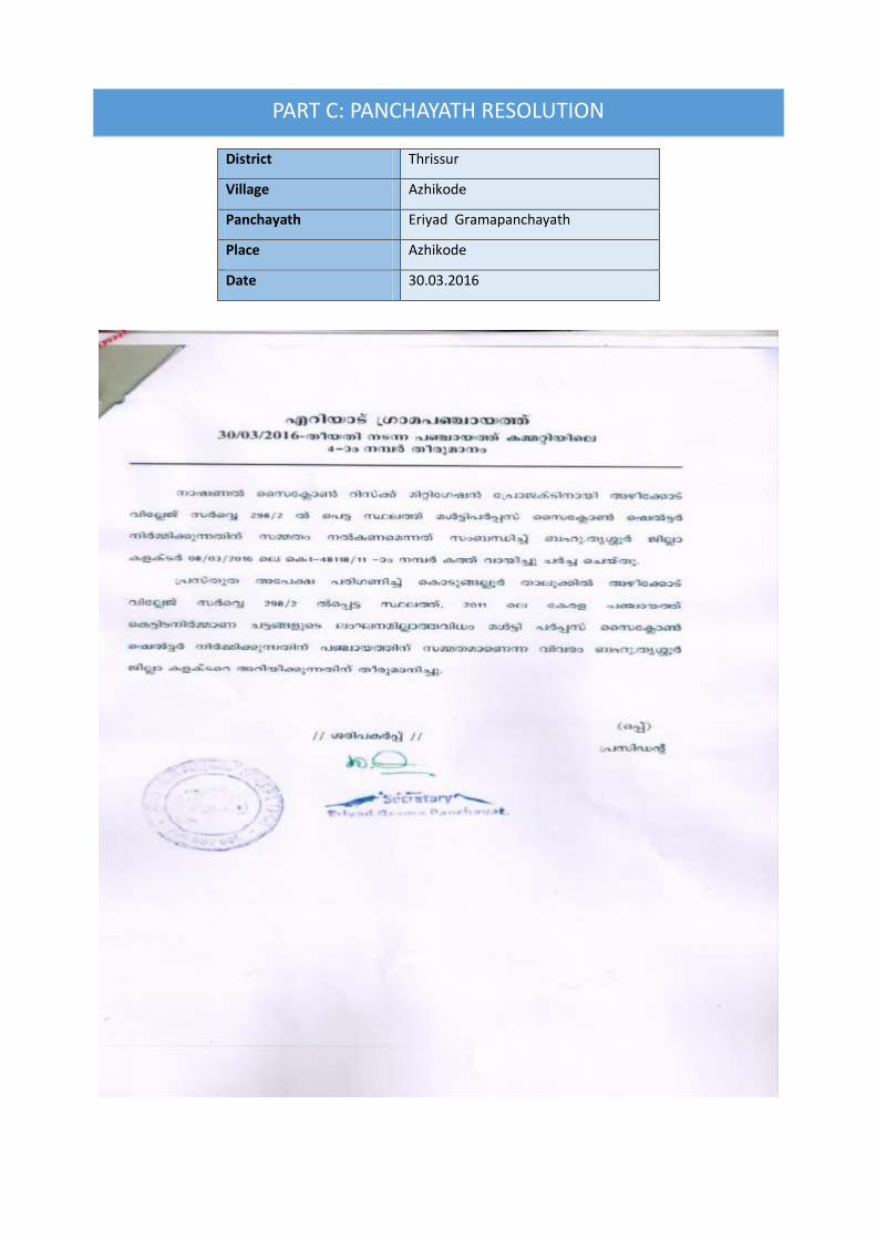
PART C: PANCHAYATH RESOLUTION
District Thrissur
Village Azhikode
Panchayath Eriyad Gramapanchayath
Place Azhikode
Date 30.03.2016

112
Summary of the Panchayath meeting decision:
11. Eriyad Gramapanchayath discussed on the letter from District Administration intimating on
decision taken in Government Order: G.O (Rt) no. 641/2016/DMD dated 28.01.2016 to
construct a Multi-Purpose Cyclone Shelter in the compound of Azhikode Village Office,
Azhikode Village.
12. The Panchayath has considered the matter and agreed to construct MPCS in Azhikode Village
of Kodungalloor Taluk and further states that the construction should abide to the Kerala
Panchayath Building Rules 2011.

113
Part A: General Information about the sub-project
Sub Project id NCRMP/KER/KSD/ CHVD/KADAPPURAM-1
Type of proposed sub-project activity MPCS
Location of the sub project activity
State Kerala
District Thrissur
Taluk Chavakkad
Village Kadappuram
Panchayath/Municipal Corporation Kadappuram Gramapanchayath
Survey Number Survey number: 101/4B
Latitude 10⁰ 32' 21.6”N
Longitude 76⁰ 1' 41.3"E
Mean Sea Level 20 m
Size of the sub-project
Cyclone Shelter – approx. built up area 900 S.M
Land requirement for the sub project (in Ha or m2)
Total Requirement
p. Private Land Nil
q. Government Land 500 SQ.M
r. Forest Land Nil
Existing Land use Dilapidated building
Approach roads
Road name Anjagadi road
Existing road Sit is directly accessible from the road
Proposed road No approach road proposed.
Boundary wall requirement No
Part B: Ascertaining whether the site is a prohibited site PART B1: List of sites where sub-projects are prohibited
Is the sub-project located in whole or within any of the following environmentally sensitive area?
Remarks if any
Biosphere reserve No
National Park No
Wildlife/Bird sanctuary No
Game reserve No
Tiger reserve/elephant reserve No
Wetland No
Important bird areas No
Coastal area with corals No
Mangrove area No
2. MPCS AT KADAPPURAM VILLAGE
PART A: ESMF CHECKLIST

114
Estuary with mangroves No
Turtle nesting grounds No
Swamps/mudflats No
Notified sensitive eco zone No
Is the sub-project located in whole or in part between the HTL and the LTL?
No The site is 500 m from coastline
Is the sub-project located in whole or in part 200 metres from an estuary boundary?
No
Is the sub-project located in whole or in part 500 meters from flood plain or modified flood plain or by flood control systems of a riverine system?
No
Is the sub-project located in whole or in part 500 meters from railway line?
No
Is the sub-project located in whole or in part within 100 meters from the protected limits of notified archaeological sites or monuments?
No
Is the sub-project located in whole or in within 1km radius of:
Historic places that are regionally or locally important
No
Reservoirs/Dams No
Religious Places No
Public water bodies No A water tank/pump room is located near
to the site
PART C: Environmental Screening Forms PART C1: Proximity to Coastal Regulatory Zone:
Is the sub-project located in whole or part within the Coastal Regulation Zone?
No Outside CRZ ( 500m from HTL)
PART C2: Proximity to Environmentally Sensitive areas:
Not applicable as the construction area is less than 900 SQ.M.
PART C3: Environmental screening – outcome Screening outcome
Based on the updating of the screening results, the following clearances are required
CRZ clearance Not applicable
Environmental clearance Not applicable
Forest clearance Not applicable
PART D: Social Screening PART D1: Identification of potential social concerns
1.Does the proposed sub-project activity require any land? Remarks if any

115
Private Land No
Government Land Yes Approximately 500 SQ.M of land under ownership of Revenue Department.
Forest Land No
2. Does the proposed sub-project activity result in demolition/removal of existing structures?
No
Number of public structures/buildings No
Number of common property resources (such as religious/cultural/ drinking water/wells/etc)
No
Number of private structures (located on private or public land)
No
3. Does the proposed Project activity result in loss of crops/trees which is not Government property?
No Numerous tree in the site has to be
cut down to facilitate
construction
4. Does the proposed Project activity result in loss of direct livelihood/ employment?
No
5. Does the proposed activity result in loss of mangrove ecosystem/social forest on which nearby residents/local population are dependent for fuel wood/grazing etc.?
No
6. Does the proposed Project activity affect scheduled tribe/ caste communities?
No
Part D (2): Result/Outcome of Social Screening Exercise Outcome
Social Impact Assessment is required No
Abbreviated RAP is required No
Full RAP is required No
Details of Screening Exercise
Name Mary Midhula Maxy
Designation Environmental and Social Specialist, State Project Implementation Unit, NCRMP-Kerala
116
Description of Environmental and Social features
The proposed Multipurpose Cyclone Shelter will be constructed in Kadappuram Village of
Chavakkad taluk in Thrissur District. The site is entitled to Revenue Department.
The site is located at a distance of 500 m from coastline and is 1 km away from Biosphere
reserve, National Park, Wildlife/Bird Sanctuary, Tiger or Elephant Reserves, Important Bird areas,
Mangroves Habitat of Migratory birds, Migratory route of Wild Animals/Birds,
Reserved/Protected Forest, Zoological Park, Botanical Garden.
The site is not located within or at a distance of 1km from World Heritage Sites,
Archaeological monuments [under ASI’s Central/State list].
The site is within the Kadappuram village office compound. Apart from Village office that
functions in the site, Panchayath water tank /pump room and an old building dilapidated
building is situated within the compound. The entrance to the site is very narrow and is of
approximate width of 2 meters for a distance of 3 meters. Provision for a new entry to the site is
currently not available. A water tank within the possession of Panchayath is adjacent to the
proposed site. A Panchayath office also functions near the water tank. Numerous trees will have
to be cut down to facilitate construction.
Approach roads
The site is directly accessible from Anjangadi road. Upgradation of exisitig road I not proposed.
Demography of Kadappuram Village
According to 2011 Census, the village has 4624 households. The proposed Multipurpose Cyclone Shelter
is expected to benefit the Village Population during emergencies. The categories of population in the
village are given below in Table.
Table [Source: Census, 2011]
Population Persons
Total 22,938
Male 10,522
Female 12,416
In the age group 0-6 years 2,975
Scheduled Castes (SC) 155
PART B: BRIEF REPORT

117
Scheduled Tribes (ST) 1224
Literates 12,232
Illiterate 3,333
Worker 6,406
Non Worker 9,159
Legal Clearances
Environmental Clearance
As per EIA notification, 2006 environmental clearance is mandatory for projects with built
up area more than 20,000 sq mt. Since, the built up area of Azhikode MPCS is only 900 sq.mt,
project does not necessitate any Environmental clearance.
CRZ Clearance
Azhikode MPCS is 500 m from the High Tide Line and is not within the Coast Regulation
Zone. Hence, the project does not require clearance as per CRZ notification, 2011.
Forest Clearance
Since, diversion of forest area or felling of roadside plantation is not required during any
phase of construction of Azhikode MPCS clearance as per Forest (Conservation) Act, 1980 is not
applicable.

4. Aerial view of the site 2. Dilapidated building in the site (Water tank/pump house can be seen)
3. View of the site 4. Entry to the site

GIS map of MPCS at Kadappuram Village

120
District Thrissur
Village Kadappuram
Panchayath Kadappuram Gramapanchayath
Place Kadappuram
Date 01.08.2016
PART C: PANCHAYATH RESOLUTION

121
Summary of the Panchayath meeting decision:
1. Kadappuram Gramapanchayath discussed on the letter from District Administration
intimating on decision taken in Government Order: G.O (Rt) no. 641/2016/DMD dated
16.07.2016 to construct a Multi-Purpose Cyclone Shelter in the compound of Kadappuram
Village Office, Kadappuram Village.
2. The Panchayath in its resolution no 4(20) dated 01.08.2016 had accepted and agreed on the
decision to construct MPCS in Kadappuram Village of Chavakkad Taluk.

122
7. District: Ernakulam

123
Ernakulam District
Ernakulam district covers an area of 3,068 km2 located on the Western Coastal Plains of India. It
is surrounded by Thrissur District to the north, Coimbatore District of Tamil Nadu to the north-east,
Idukki District to the east, Alappuzha and Kottayam districts to the south and Lakshadweep sea to
west. The district can be divided geographically into highland, midland and coastal area. The altitude
of the highland is about 300 m. It has an average elevation of 4 m and a coast line of 46 kms.
The sites selected for construction of Multipurpose Cyclone shelters in Ernakulam District are
at Pallipuram Village, Kumbalanghi village and Moothakunnam village of Ernakulam District. Sites at
Puthenvelikara village and Njarakkal village were considered for the project but due to public
disapproval alternate sites were considered.
Profile of Ernakulam
Headquarters Kakkanad
Total Population 32,82,388
Male 16,19,557
Female 16,62,831
Population Growth 5.6%
Density/Km2 1072
Number of Taluks 7
Number of Villages 117
Number of Panchayath Wards 88
Forest Area 823.8302 Km2
Average Rainfall 3,000mm
Temperature Min: 27˚C
Max:32˚C
Number of major rivers 2
Major Soil Laterite soil Sandy loam
alluvial soil
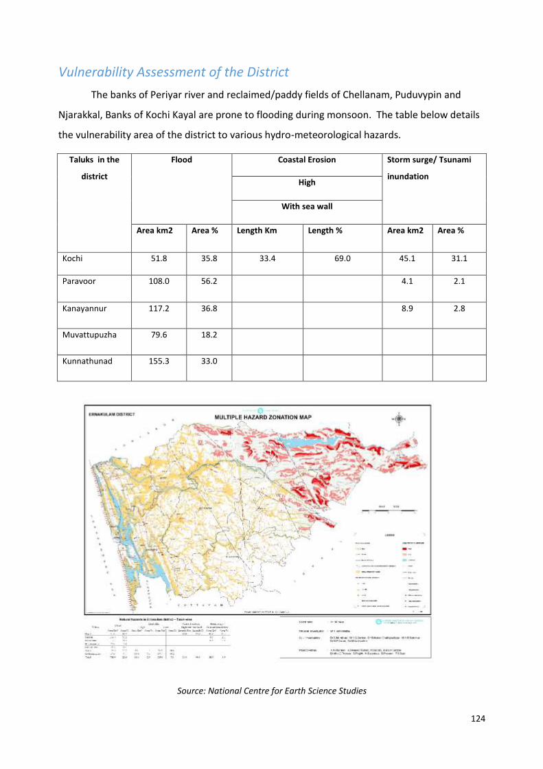
124
Vulnerability Assessment of the District
The banks of Periyar river and reclaimed/paddy fields of Chellanam, Puduvypin and
Njarakkal, Banks of Kochi Kayal are prone to flooding during monsoon. The table below details
the vulnerability area of the district to various hydro-meteorological hazards.
Taluks in the
district
Flood Coastal Erosion Storm surge/ Tsunami
inundation High
With sea wall
Area km2 Area % Length Km Length % Area km2 Area %
Kochi 51.8 35.8 33.4 69.0 45.1 31.1
Paravoor 108.0 56.2 4.1 2.1
Kanayannur 117.2 36.8 8.9 2.8
Muvattupuzha 79.6 18.2
Kunnathunad 155.3 33.0
Source: National Centre for Earth Science Studies

125
5. MPCS AT PALLIPURAM VILLAGE
PART A: ESMF CHECKLIST
Part A: General Information about the sub-project
Sub Project id NCRMP/KER/EKM/KOC/PALLIPURAM-1
Type of proposed sub-project activity MPCS
Location of the sub project activity
State Kerala
District Ernakulam
Taluk Kochi
Village Pallippuram
Panchayath/Municipal Corporation Pallipuram Panchayath
Survey Number Block:2, Survey number: 196/5
Latitude 10⁰ 09' 45.1' N
Longitude 76⁰ 11' 13.5"E
Size of the sub-project
Cyclone Shelter – approx. built up area 600 SQ.M
Land requirement for the sub project (in Ha or m2)
Total Requirement
p. Private Land Nil
q. Government Land 600 SQ.M of land under the ownership of Revenue
r. Forest Land Nil
Existing Land use Barren land used as playground.
Approach roads
Road name Pallipuram Village office road
Existing road Length: 200m ROW: 4.5m
Proposed road Unpaved road
Boundary wall requirement Yes
Part B: Ascertaining whether the site is a prohibited site
PART B1: List of sites where sub-projects are prohibited
Is the sub-project located in whole or within any of the following environmentally sensitive area?
Remarks if any
Biosphere reserve No
National Park No
Wildlife/Bird sanctuary No
Game reserve No
Tiger reserve/elephant reserve No
Wetland No
Important bird areas No
Coastal area with corals No
Mangrove area No
Estuary with mangroves No
Turtle nesting grounds No
126
Swamps/mudflats No
Notified sensitive eco zone No
Is the sub-project located in whole or in part between the HTL and the LTL?
No
Is the sub-project located in whole or in part 200 metres from an estuary boundary?
No
Is the sub-project located in whole or in part 500 meters from flood plain or modified flood plain or by flood control systems of a riverine system?
No
Is the sub-project located in whole or in part 500 meters from railway line?
No
Is the sub-project located in whole or in part within 100 meters from the protected limits of notified archaeological sites or monuments?
No
Is the sub-project located in whole or in within 1km radius of:
Historic places that are regionally or locally important
No
Reservoirs/Dams No
Religious Places No
Public water bodies Yes A pond exists near adjacent to the site
PART C: Environmental Screening Form PART C1: Proximity to Coastal Regulatory Zone:
Is the sub-project located in whole or part within the Coastal Regulation Zone?
No Site is 180m from Waterbody and 1 km from coastline
PART C2: Proximity to Environmentally Sensitive areas:
Not applicable as the construction area is less than 600 SQ.M.
PART C3: Environmental screening – outcome
Screening outcome
Based on the updating of the screening results, the following clearances are required
CRZ clearance Not applicable
Environmental clearance Not applicable
Forest clearance Not applicable
PART D: Social Screening
PART D1: Identification of potential social concerns Remarks if any
1. Does the proposed sub-project activity require any land?
Private Land No
Government Land Yes Approximately 600 SQ.M of land under ownership of Revenue Department.

127
Forest Land No
2. Does the proposed sub-project activity result in demolition/removal of existing structures?
No
Number of public structures/buildings No
Number of common property resources (such as religious/cultural/ drinking water/wells/etc)
Yes A pond exists near adjacent to the site. A temple is located
near to the site
Number of private structures (located on private or public land)
No
Part D (2): Result/Outcome of Social Screening Exercise
Outcome
Social Impact Assessment is required No
Abbreviated RAP is required No
Full RAP is required No
Details of Screening Exercise
Name Mary Midhula Maxy
Designation Environmental and Social Specialist, State Project Implementation Unit

128
PART B: BRIEF REPORT
Description of Environmental and Social features
The proposed site is located near to the Village office of Pallipuram and is currently used as play ground.
A pond exists within close proximity to the site. The MPCS could be used for various purposes of the District
Administration and Panchayath activities. The District Administration has reported that a vulnerable
population that figures to 2500 exists in the locality. Schools and Auditoriums are used as shelters in the village
during floods or heavy rains.
The site is located at a distance of 1 km from coastline and is 1 km away from Biosphere reserve,
National Park, Wildlife/Bird Sanctuary, Tiger or Elephant Reserves, Important Bird areas, Mangroves
Habitat of Migratory birds, Migratory route of Wild Animals/Birds, Reserved/Protected Forest, Zoological
Park, Botanical Garden. The site is not located within or at a distance of 1km from World Heritage Sites,
Archaeological monuments [under ASI’s Central/State list].
Approach roads
The site is connected to Village office road via untarred Panchayath roads. The upgradation of
approach road is considered in the project.
Demography of Pallipuram Village
According to 2011 Census, the village has 8056 households. The proposed Multipurpose Cyclone Shelter
is expected to benefit the Village Population during emergencies. The categories of population in the
village are given below in Table.
Table [Source: Census, 2011]
Population Persons
Total 32,321
Male 15,866
Female 16,455
In the age group 0-6 years 2,581
Scheduled Castes (SC) 3,331
Scheduled Tribes (ST) 87
Literates 28,802
129
Illiterate 3,519
Worker 12,073
Non Worker 20,248
Legal Clearances
Environmental Clearance
As per EIA notification, 2006 environmental clearance is mandatory for projects with built up area
more than 20,000 sq mt. Since, the built up area of Pallipuram MPCS is only 1800 sq.mt, project does not
necessitate any Environmental clearance.
CRZ Clearance
Pallipuram MPCS is 1 km from the High Tide Line and is not within the Coast Regulation Zone.
Hence, the project does not require clearance as per CRZ notification, 2011.
Forest Clearance
Since, diversion of forest area or felling of roadside plantation is not required during any phase of
construction of Pallipuram MPCS clearance as per Forest (Conservation) Act, 1980 is not applicable.

1. Aerial view of the site 2. View of the site
3.View of the site (Village office compound wall seen to left) 4. Pond near to the site
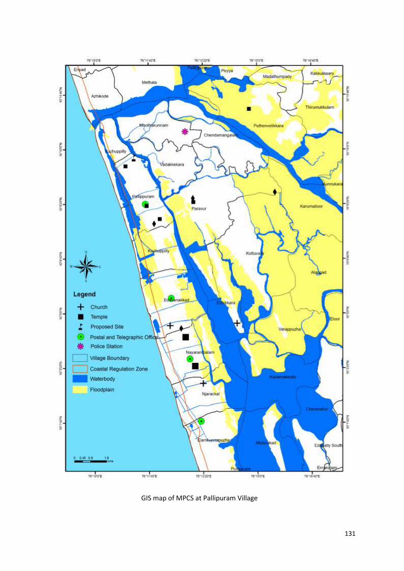
131
GIS map of MPCS at Pallipuram Village

PART C: PANCHAYATH RESOLUTION
District Ernakulam
Village Pallipuram
Panchayath Pallipuram Gramapanchayath
Place Kumbla
Date 14.03.2016

133
Summary of the Panchayath meeting decision:
1. The meeting presided over by President, Pallipuram Panchayath, started at 11.00 am.
The following officers were present.
President,Pallipuram Panchayath
Vice President,Pallipuram Panchayath
Secreatary,Pallipuram Panchayath
Village Officer,Pallipuram
Ward Members
Local Community Mobiliser, NCRMP-Phase II
2. The President, Pallipuram Panchayath welcomed all the officers to the meeting.
Mrs.Susmy Sunny,Local Community Mobiliser, NCRMP-Phase II, briefed about the
project. The following points were discussed in the meeting regarding the Cyclone shelter
construction under NCRMP-Phase-II.
Secretary presented the agenda of the meeting.
Junior Superintendent, Kochi Taluk briefed about the project and related matters.
Ward member discussed the issues regarding approach road to the proposed cyclone
shelter site in Pallipuram Panchayath.
Local community Mobiliser clarified about the issue. The construction of approach road
is also included in the NCRMP project.
3. Pallipuram Grama Panchayath in its resolution noV dated 14.03.2016 agreed and
accepted the decision to construct a multipurpose cyclone shelter at Revenue land near
village office of Pallipuram.
4. The Panchayath does not see any adverse environmental and social issues related to
construction of MPCS

3. MPCS AT MOOTHAKUNNAM VILLAGE
PART A: ESMF CHECKLIST
Part A: General Information about the sub-project
Sub Project id NCRMP/KER/EKM/PAR/MOOTHAKUNNAM-1
Type of proposed sub-project activity MPCS
Location of the sub project activity
State Kerala
District Ernakulam
Taluk Paravur
Village Moothakunnam
Panchayath/Municipal Corporation Vadakkekara Panchayath
Survey Number
Survey number
252/3A,B, 252/2-3,
252/1-2
Latitude 10⁰ 10’ 22.2”N
Longitude 76⁰ 12’ 43.4”E
Size of the sub-project
Cyclone Shelter – approx. built up area 900 SQ.M
Land requirement for the sub project (in Ha or m2)
Total Requirement
a. Private Land Nil
b. Government Land 5O0 SQ.M of land in the ownership of Education Department
c. Forest Land Nil
Existing Land use Trees and shrubs are present in the site
Approach roads
Road name Site is to the LHS of National Highway
Existing road -
Proposed road No approach roads proposed
Boundary wall requirement No
Part B: Ascertaining whether the site is a prohibited site PART B1: List of sites where sub-projects are prohibited
Is the sub-project located in whole or within any of the following environmentally sensitive area?
Remarks if any
Biosphere reserve No
National Park No
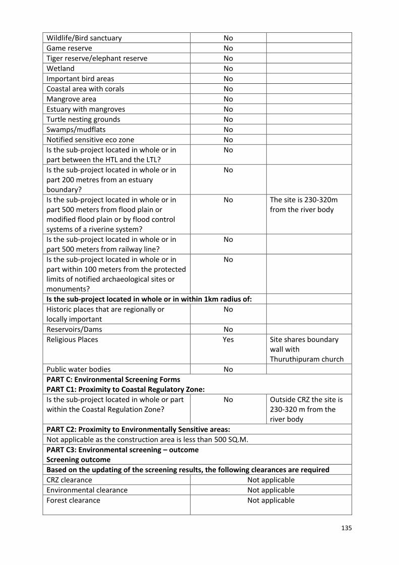
135
Wildlife/Bird sanctuary No
Game reserve No
Tiger reserve/elephant reserve No
Wetland No
Important bird areas No
Coastal area with corals No
Mangrove area No
Estuary with mangroves No
Turtle nesting grounds No
Swamps/mudflats No
Notified sensitive eco zone No
Is the sub-project located in whole or in part between the HTL and the LTL?
No
Is the sub-project located in whole or in part 200 metres from an estuary boundary?
No
Is the sub-project located in whole or in part 500 meters from flood plain or modified flood plain or by flood control systems of a riverine system?
No
The site is 230-320m from the river body
Is the sub-project located in whole or in part 500 meters from railway line?
No
Is the sub-project located in whole or in part within 100 meters from the protected limits of notified archaeological sites or monuments?
No
Is the sub-project located in whole or in within 1km radius of:
Historic places that are regionally or locally important
No
Reservoirs/Dams No
Religious Places Yes Site shares boundary wall with Thuruthipuram church
Public water bodies No
PART C: Environmental Screening Forms PART C1: Proximity to Coastal Regulatory Zone:
Is the sub-project located in whole or part within the Coastal Regulation Zone?
No Outside CRZ the site is 230-320 m from the river body
PART C2: Proximity to Environmentally Sensitive areas:
Not applicable as the construction area is less than 500 SQ.M.
PART C3: Environmental screening – outcome Screening outcome
Based on the updating of the screening results, the following clearances are required
CRZ clearance Not applicable
Environmental clearance Not applicable
Forest clearance Not applicable

136
PART D: Social Screening PART D1: Identification of potential social concerns
1. Does the proposed sub-project activity require any land? Remarks if any
Private Land No
Govt. Land Yes 400 SQ.M of land under the ownership of Education Department
Forest Land No
2. Does the proposed sub-project activity result in demolition/removal of existing structures?
Number of public structures/buildings Nil Building of Sarva Shiksha Abhiyan Centre functions in the school premises near to the site.
Number of common property resources (such as religious/cultural/ drinking water/wells/etc)
Number of private structures (located on private or public land)
Nil
3. Does the proposed Project activity result in loss of crops/trees which is not Government property?
No Several trees in Government land will have to be cut down
to facilitate construction
4. Does the proposed Project activity result in loss of direct livelihood/ employment?
No
5. Does the proposed activity result in loss of mangrove ecosystem/social forest on which near by residents/local population are dependent for fuel wood/grazing etc.?
No
6. Does the proposed Project activity affect scheduled tribe/ caste communities?
No
Part D (2): Result/Outcome of Social Screening Exercise Outcome
Social Impact Assessment is required No
Abbreviated RAP is required No
Full RAP is required No
Details of Screening Exercise
Name Mary Midhula Maxy
Designation Environmental and Social Specialist, State Project Implementation Unit, NCRMP-Kerala

137
Description of Environmental and Social features
The proposed site is located within the premises of S.N Government Lower Primary School,
Thuruthipuram of Moothakunnam village in Ernakulam district. The site shares boundary with
Thuruthipuram Church and another private school.
The site is located 1 km away from Biosphere reserve, National Park, Wildlife/Bird Sanctuary,
Tiger or Elephant Reserves, Important Bird areas, Mangroves Habitat of Migratory birds, Migratory route
of Wild Animals/Birds, Reserved/Protected Forest, Zoological Park, Botanical Garden and coastline. The
site is 230-320m from the river body.
The site is not located within or at a distance of 1km from World Heritage Sites, Archaeological
monuments (under ASI’s Central/State list).
Several Trees will have to be cut down to clear the land for construction. A well is located at the
farthest end of the site. The MPCS could be used for various purposes of the school and Panchayath activities.
The District Administration has reported that a vulnerable population that figures to 4000 exists in the
locality. Schools and community halls are used as shelters in the village during floods or heavy rains.
Approach roads
The site is directly accessible from National Highway.
Demography of Moothakunnam Village
According to 2011 Census, the village has 6,963 households. The proposed Multipurpose Cyclone Shelter
is expected to benefit the Village Population during emergencies. The categories of population in the
village are given below in Table.
Table [Source: Census, 2011]
Population Persons
Total 27,458
Male 13,279
Female 14,179
In the age group 0-6 years 2,145
Scheduled Castes (SC) 1,224
Scheduled Tribes (ST) 103
Literates 24,552
Illiterate 2,906
Worker 10,735
PART B: BRIEF REPORT

138
Non Worker 16.723
Legal Clearances
Environmental Clearance
As per EIA notification, 2006 environmental clearance is mandatory for projects with built up
area more than 20,000 sq mt. Since, the built up area of Moothakunnam MPCS is only 500 sq.mt, project
does not necessitate any Environmental clearance.
CRZ Clearance
Moothakunnam MPCS is is 230-320 m from the river body and is not within the Coast
Regulation Zone. Hence, the project does not require clearance as per CRZ notification, 2011.
Forest Clearance
Since, diversion of forest area or felling of roadside plantation is not required during any phase of
construction of Moothakunnam MPCS clearance as per Forest (Conservation) Act, 1980 is not applicable.
However, clearance from Village Office is required to cut down the trees in the site to facilitate
construction.

1.Aerial view of the site 2. View of the site from access road (Church can be seen)
3.View of the site 4.School premises
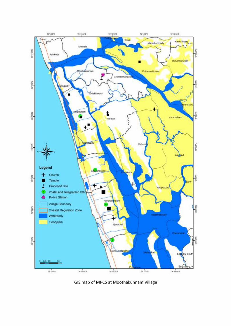
GIS map of MPCS at Moothakunnam Village

141
District Ernakulam
Village Moothakunnam
Panchayath Vadakkekara Gramapanchayath
Place Moothakunnam
Date 19.03.2016
PART C: PANCHAYATH RESOLUTION

142
Summary of the Panchayath meeting decision:
1.The meeting presided over by President, Vadakkekkara Panchayath and the following officers
were present.
Vice President, Vadakkekkara Panchayath
Secreatary, Vadakkekkara Panchayath
Deputy Tahsildar,HQ,Paravur Taluk
Village Officer, Moothakunnam
School Representatives(Two persons)
Ward Members
Local Community Mobiliser,NCRMP-Phase II
2.The President, Vadakkekkara Panchayath addressed the meeting. Local Community Mobiliser,
NCRMP-Phase II, briefed about the project. The following points were discussed in the meeting
regarding the Cyclone shelter construction under NCRMP-Phase-II.
Secretary presented the agenda of the meeting.
Deputy Tahsildar, HQ, Paravur Taluk briefed about the project and related matters.
School representatives submitted an objection to this construction. They are planning
to construct a new building for school. There is no enough space to construct a new
building for school after the construction of cyclone shelter.
Local community Mobiliser gave clarification about the issues. The proposed cyclone
shelter is a multipurpose building. It can also be used for other purposes like school
building, community centres etc.
Ward members discussed the issues regarding the cyclone shelter construction.
3.Vadakkekkara Grama Panchayath in its resolution no dated 19.03.2016 agreed and accepted
the decision of the State Government to construct a multipurpose cyclone shelter at
Moothakunnam near Sarva Shiksha Abhiyan,Thuruthippuram.
4. The Panchayath sees no adverse environmental and social issues due to construction of MPCS.

143
8. District: Alappuzha

144
Alappuzha District Alappuzha is one among the nine coastal districts of Kerala were the project is being
implemented. Alappuzha district is located at latitude between 9°05' -9.54°N and longitude
between 76°16'-76°46’ E and is bounded by Lakshadweep Sea on the west, Kottayam and
Pathanamthitta districts on the East and Ernakulam District in the North.The 82km long coast of
Alappuzha, which borders 30 coastal villages, is vulnerable to storm surges, cyclones, high tides
and coastal erosion. High tides and storm surges are common during monsoon period and the
district is moderately prone to cyclones.
Construction of Multi-Purpose Cyclone Shelters [MPCS] is proposed in Pallipad,
Kumarapuram, Cheruthana, Purakkad, Mararikulam North and Kainakari North villages of
Alappuzha.
Profile of Alappuzha
Headquarters Alappuzha
Total Population 21,21,943
Male 10,10,252
Female 11,11,691
Population Growth 0.61%
Density/Km2 1501
Number of Taluks 6
Number of Villages 93
Number of Panchayath Wards 1186
Forest Area 5.80 Ha
Average Rainfall 2,600 mm
Temperature Min: 23.9˚C
Max:30.7˚C
Number of major rivers 3
Major Soil Coastal plain soil

145
Vulnerability Assessment of the District
The banks of major rivers Manimala river, Pamba river, Achenkoil river, their rivulets,
banks of Vembanad lake, Kayamkulam lakeand paddy fields are prone to flooding during
monsoon. Alappuzha being a low lying region, with less than 8 m elevation, is at high risk of
inundation during such events.The table below details the vulnerability area of the district to
various hydro-meteorological hazards.
Table [Source: CESS]
Taluk Flood Storm surge/Tsunami
inundation
Coastal Erosion
Area Km2 Area % Area Km2 Area % Area Km2 Area %
Ambalappuzha 73.8 40.4 5.7 3.1 7.7 22.9
Cherthala 115.6 35.6 7.9 2.4 5.7 26.2
Karthikappally 123.1 55.2 30.5 13.2 20.3 85.7
Source: National Centre for Earth Science Studies

146
Part A: General Information about the sub-project
General information about the sub project
Sub Project id NCRMP/KER/ALP/ KAR/KUMARAPURAM-1
Type of proposed sub-project activity MPCS
Location of the sub project activity
State Kerala
District Alappuzha
Taluk Karthikappally
Village Kumarapuram
Panchayath/Municipal Corporation Karuvatta Panchayath
Survey Number Block no: 2, 529/13
Latitude 9⁰ 18’ 22.714”N
Longitude 76⁰ 25’ 56.349”E
Mean Sea Level 4.5 m
Size of the sub-project
Cyclone Shelter – approx. built up area 960 SQ.M
Land requirement for the sub project (in Ha or m2)
Total Requirement
a. Private Land Nil
b. Government Land 500 SQ.M
c. Forest Land Nil
Existing Land use Fallow land
Approach roads
Road name Panchayath road
Existing road -
Proposed road No Approach roads proposed
Boundary wall requirement Yes
Part B: Ascertaining whether the site is a prohibited site PART B1: List of sites where sub-projects are prohibited
Is the sub-project located in whole or in part of any of the following environmentally sensitive areas:
Remarks if any
Biosphere reserve No
National Park No
Wildlife/Bird sanctuary No
Game reserve No
Tiger reserve/elephant reserve No
Wetland No
Water logged paddy fields and inland wetlands are found
within 1km radius of the site.
Important bird areas No
Coastal area with corals No
Mangrove area No
2. MPCS AT KUMARAPURAM VILLAGE
PART A: ESMF CHECKLIST

147
Estuary with mangroves No
Turtle nesting grounds No
Swamps/mudflats No
Notified sensitive eco zone No
Is the sub-project located in whole or in part between the HTL and the LTL?
No
Is the sub-project located in whole or in part 200 metres from an estuary boundary?
No
Is the sub-project located in whole or in part 500 meters from flood plain or modified flood plain or by flood control systems of a riverine system?
No 1.6 km from stream of Pamba
river
Is the sub-project located in whole or in part 500 meters from railway line?
No
Is the sub-project located in whole or in part within 100 meters from the protected limits of notified archaeological sites or monuments?
No
Is the sub-project located in whole or in within 1km radius of:
Historic places that are regionally or locally important
No
Reservoirs/Dams No
Religious Places Yes Kaduvan Kulangara Temple at a distance of 30m north to the site.
Public water bodies No
PART C: Environmental Screening Form PART C1: Proximity to Coastal Regulatory Zone:
Is the sub-project located in whole or part within the Coastal Regulation Zone?
No
Outside CRZ [5km from
Coastline]
PART C2: Proximity to environmentally sensitive areas:
Not applicable as the construction area is only 500 SQ.M.
PART C3: Environmental screening – outcome Screening outcome
Based on the updating of the screening results, the following clearances are required
CRZ clearance No
Environmental clearance No
Forest clearance No
PART D: Social Screening PART D1: Identification of potential social concerns

148
1. Does the proposed sub-project activity require any land? Remarks if any
Private Land No
Govt. Revenue Land Yes 500 SQ.M of land in ownership of Education Department.
Forest Land No
2. Does the proposed sub-project activity result in demolition/removal of existing structures?
Number of public structures/buildings 3 (Three)
2 (Two) dilapidated Anti Disaster shelters constructed by European Economic Community in 1984 has to be demolished to facilitate entry to the proposed MPCS] A dilapidated lavatory needs to be demolished during site preparation.
Number of common property resources (such as religious/cultural/ drinking water/wells/etc)
Part of school gate and wash area needs to be demolished for facilitating entry of vehicles to the site
Number of private structures (located on private or public land)
Nil
3. Does the proposed Project activity result in loss of crops/trees which is not Government property?
No
4. Does the proposed Project activity result in loss of direct livelihood/ employment?
No
5. Does the proposed activity result in loss of mangrove ecosystem/social forest on which near by residents/local population are dependent for fuel wood/grazing etc.?
No
6. Does the proposed Project activity affect scheduled tribe/ caste communities?
No
Part D (2): Outcome of Social Screening Exercise Outcome
Social Impact Assessment is required No
Abbreviated RAP is required No
Full RAP is required No
Details of Screening Exercise
Name Mary Midhula Maxy
Designation Environmental and Social Specialist, State Project Implementation Unit

149
Description of Environmental and Social Features
The proposed Multipurpose Cyclone Shelter will be constructed in Kumarapuram Village
of Karthikapally taluk in Alappuzha District. The site is within the boundary of Government L.P
School, Kumarapuram. The land is entitled to Education Department and requires consensus
from Education Department prior to implementation of construction works.
The site is located at a distance of 5km from Arabian Sea. The proposed site has no
Biosphere reserve, National Park, Wildlife/Bird Sanctuary, Tiger or Elephant Reserves, Important
Bird areas, Mangroves Habitat of Migratory birds, Migratory route of Wild Animals/Birds,
Reserved/Protected Forest, Zoological Park and Botanical Garden within 1km extent.
The site is not located within or at a distance of 1km from World Heritage Sites,
Archaeological monuments [under ASI’s Central/State list]. A temple is situated at a distance of
30m to the north of the school compound. National Highway 47 is at a distance of 20m to the
west of the site.
The proposed site is presently fallow and is used for grazing. Trees will have to be felled
during site preparation phase. The school gate requires to be widened to facilitate entry of
vehicles from the National highway to the site. A portion of the wash area which is close to the
school gate has to be demolished for this purpose. Entry of vehicles to the site is not possible
without passing across two dilapidated buildings [Anti disaster shelters] at the back portion of
the school building. These buildings were constructed by European Economic Community in 1984
and are owned by the Revenue Department. Hence, demolition of these buildings and widening
of the school gate is requisite for providing direct entry to the MPCS from NH 47.
Approach roads
The proposed site is at a distance of 20m from NH 47. No approach roads have been
proposed for the MPCS.
PART B: BRIEF REPORT

150
Demography of Kumarapuram Village
According to 2011 Census, the village has 7020 households. The proposed Multipurpose
Cyclone Shelter is expected to benefit the Village Population during emergencies. The categories
of population in the village are given below in Table 1.7.
Table [Source: Census,2011]
Population Persons
Total 26,943
Male 12,397
Female 14,546
In the age group 0-6 years 2,381
Scheduled Castes (SC) 1,182
Scheduled Tribes (ST) 149
Literates 23,386
Illiterate 3,557
Total Worker 9,848
2.4 Legal Clearances
Environmental Clearance
As per EIA notification, 2006 environmental clearance is mandatory for projects with built
up area more than 20,000 sqmt. Since, the built up area of Kumarapuram MPCS is only700 sqmt,
project does not necessitate any environmental clearance.
CRZ Clearance
Kumarapuram MPCS is 5 Km from the High Tide Line and is outside Coast Regulation Zone.
Hence, the project does not oblige to regulations as per CRZ notification, 2011.
Forest Clearance
Since, diversion of forest area or felling of roadside plantation is not required during any
phase of construction of Kumarapuram MPCS, clearance as per Forest (Conservation) Act, 1980
is not applicable.

5. Aerial view of the site 2. Kumarapuram School compound
3 and 4. Anti-disaster shelters and entry to the site
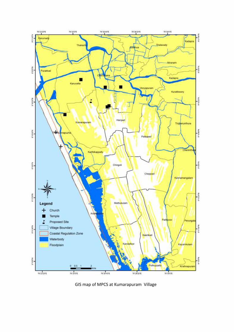
GIS map of MPCS at Kumarapuram Village

153
District Alappuzha
Village Kumarapuram
Panchayath Karuvatta
Place Kumarapuram
Date 18.11.2014
PART C: PANCHAYATH RESOLUTION

154
Summary of the Panchayath meeting decision:
8. Karuvatta Gramapanchayath discussed on decision taken in Government for constructing a
Multi-Purpose Cyclone Shelter in Block no: 2, 529/13, Government Lower Primary School of
Kumarapuram Village in its meeting held on 18.11.2014.
9. The Panchayath understands that construction of MPCS would benefit the population who
are affected by floods. At present, shelters are not available for sheltering the population.
10. A shelter that was built through funds from European Community Union is in a dilapidated
situation and is not suitable for shelter purposes.
11. Panchayath informed that this dilapidated building can be demolished and MPCS can be
built in the site. This MPCS could serve as shelter for vulnerable population in case of a
disaster and can be used as community centre in normal times.
12. The Panchayath agrees to construct MPCS in the village. Panchayath further states that
demolition and construction should not hinder the normal school activities.
13. The decision of Panchayath was informed to District Administration through resolution no.1
dated 18.11.2014 of Karuvatta Panchayath.

155
3. MPCS AT CHERUTHANA VILLAGE
PART A: ESMF CHECKLIST
Part A: General Information about the sub-project
General information about the sub project
Sub Project id NCRMP/KER/ALP/ KAR/CHERUTHANA-1
Type of proposed sub-project activity MPCS
Location of the sub project activity
State Kerala
District Alappuzha
Taluk Karthikappally
Village Cheruthana
Panchayath/Municipal Corporation Cheruthana Panchayath
Survey Number Block 5, esurvey no: 371/1
Latitude 9⁰ 18’19.358”
Longitude 76⁰ 26’ 47.606”
Mean Sea Level 5.5m above MSL
Size of the sub-project
Cyclone Shelter – approx. built up area 1000 SQ.M
Land requirement for the sub project (in Ha or m2)
Total Requirement
a. Private Land Nil
b. Government Land 500 SQ.M of land in the ownership of
c. Forest Land Nil
Existing Land use A dilapidated Anti Disaster Shelter constructed under European Economic Community project exists in the site.
Approach roads
Road name 100m tarred road connects the site to Harippad-Ayaparambukadavu road
Existing road Length: 100m ROW: 3m
Proposed road No Approach roads proposed
Boundary wall requirement No
Technical Monitoring Agency at District level
Part B: Ascertaining whether the site is a prohibited site PART B1: List of sites where sub-projects are prohibited
Is the sub-project located in whole or in part of any of the following environmentally sensitive areas:
Remarks if any
Biosphere reserve No
National Park No
Wildlife/Bird sanctuary No
Game reserve No

156
Tiger reserve/elephant reserve No
Wetland No
Inland wetlands and paddy fields are found within a 1km site from
the
Important bird areas No
Coastal area with corals No
Mangrove area No
Estuary with mangroves No
Turtle nesting grounds No
Swamps/mudflats No
Notified sensitive eco zone No
Is the sub-project located in whole or in part between the HTL and the LTL?
No
Is the sub-project located in whole or in part 200 metres from an estuary boundary?
No
Is the sub-project located in whole or in part 500 meters from flood plain or modified flood plain or by flood control systems of a riverine system?
No
1.3 km from Puttan Ar
Is the sub-project located in whole or in part 500 meters from railway line?
No
Is the sub-project located in whole or in part within 100 meters from the protected limits of notified archaeological sites or monuments?
No
Is the sub-project located in whole or in within 1km radius of:
Historic places that are regionally or locally important
No
Reservoirs/Dams No
Religious Places No
Public water bodies No
PART C: Environmental Screening Form PART C1: Proximity to Coastal Regulatory Zone:
Is the sub-project located in whole or part within the Coastal Regulation Zone?
No
Outside CRZ (6 km from Coastline)

157
PART C2: Proximity to environmentally sensitive areas:
Not applicable as the construction area is less than 500 SQ.M.
PART C3: Environmental screening – outcome Screening outcome
Based on the updating of the screening results, the following clearances are required
CRZ clearance No
EIA No
Forest clearance No
PART D: Social Screening PART D1: Identification of potential social concerns
1. Does the proposed sub-project activity require any land?
Yes Remarks if any
Private Land No
Government Land Yes 500 SQ.M of land in ownership of education
Department
Forest Land No
2. Does the proposed sub-project activity result in demolition/removal of existing structures?
Number of public structures/buildings
1 (One) [ Anti disaster shelter constructed under
European economic Community project]
Number of common property resources (such as religious/cultural/ drinking water/wells/etc)
No
Number of private structures (located on private or public land)
No
3. Does the proposed Project activity result in loss of crops/trees which is not Government property?
No
4. Does the proposed Project activity result in loss of direct livelihood/ employment?
No
5. Does the proposed activity result in loss of mangrove ecosystem/social forest on which
No
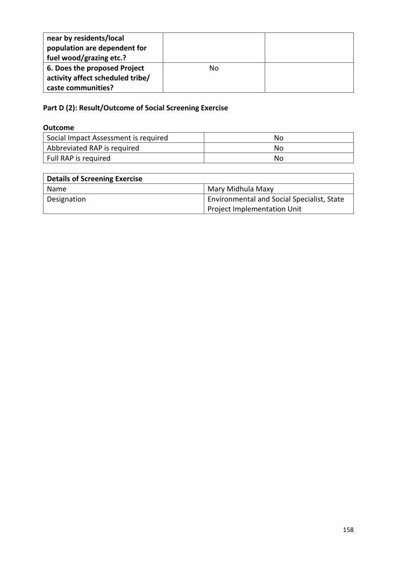
158
near by residents/local population are dependent for fuel wood/grazing etc.?
6. Does the proposed Project activity affect scheduled tribe/ caste communities?
No
Part D (2): Result/Outcome of Social Screening Exercise Outcome
Social Impact Assessment is required No
Abbreviated RAP is required No
Full RAP is required No
Details of Screening Exercise
Name Mary Midhula Maxy
Designation Environmental and Social Specialist, State Project Implementation Unit

159
Description of Environmental and Social features
The proposed Multipurpose Cyclone Shelter will be constructed in Cheruthana Village
of Karthikapally taluk in Alappuzha District. The site is adjacent to Cheruthana Village Office and
within the premises of school. The land is entitled to Education Department.
The site is located at a distance of 6 km from coastline and is 1 km away from Biosphere
reserve, National Park, Wildlife/Bird Sanctuary, Tiger or Elephant Reserves, Important Bird
areas, Mangroves Habitat of Migratory birds, Migratory route of Wild Animals/Birds,
Reserved/Protected Forest, Zoological Park, Botanical Garden.
The site is not located within or at a distance of 1km from World Heritage Sites,
Archaeological monuments [under ASI’s Central/State list]. School laboratory building exists
opposite to the existing anti disaster shelter in the site.
A dilapidated Anti Disaster shelter that exists in the site needs to be demolished and
trees needs to be cut down to prepare the site for construction. Road of width 2.5m to the
north of the site runs into the residential area.
Approach roads
The site is on the LHS of Harippad-Ayaparambu main road. No approach roads have been
proposed for the MPCS.
Demography of Cheruthana Village
According to 2011 Census, the village has 3274 households. The proposed Multipurpose
Cyclone Shelter is expected to benefit the Village Population during emergencies. The
categories of population in the village are given below in Table.
Table [Source: Census, 2011]
Population Persons
Total 12,882
Male 6,017
Female 6,865
In the age group 0-6 years 1,215
Scheduled Castes (SC) 2,227
Scheduled Tribes (ST) 56
Literates 11,157
PART B: BRIEF REPORT

160
Illiterate 1,725
Total Worker 4,962
Legal Clearances
Environmental Clearance
As per EIA notification, 2006 environmental clearance is mandatory for projects with
built up area more than 20,000 sqmt. Since, the built up area of Cheruthana MPCS is only700
sqmt, project does not necessitate any environmental clearance.
CRZ Clearance
Cheruthana MPCS and approach road is 6 km from the High Tide Line and is outside
Coast Regulation Zone. Hence, the project does not oblige to regulations as per CRZ notification,
2011.
Forest Clearance
Since, diversion of forest area or felling of road side plantation is not required during
any phase of construction of Cheruthana MPCS, clearance as per Forest (Conservation) Act,
1980 is not applicable.
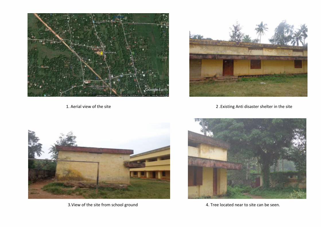
1. Aerial view of the site 2 .Existing Anti disaster shelter in the site
3.View of the site from school ground 4. Tree located near to site can be seen.

162
GIS map of MPCS at Cheruthana Village
163
District Alappuzha
Village Cheruthana
Panchayath Cheruthana Gramapanchayath
Place Cheruthana
Date 20/11/2014
PART C: PANCHAYATH RESOLUTION

164
Summary of the Panchayath meeting decision:
4. Cheruthana Gramapanchayath discussed on decision taken in Government for
constructing a Multi-Purpose Cyclone Shelter in Block no: 5, Resurvey no: 371/1,
Ayamparambu Government Higher Secondary School of Cheruthana Village in its
meeting held on 20.11.2014.
5. The Panchayath understands that construction of MPCS would benefit the population
who are affected by floods. At present, shelters are not available for sheltering the
population.
6. A shelter that was built through funds from European Community Union is in a
dilapidated situation and is not suitable for shelter purposes exists in the site.
7. Panchayath informed that this dilapidated building can be demolished and MPCS can
be built in the site. This MPCS could serve as shelter for vulnerable population in case
of a disaster and can be used as community centre in normal times.
8. The Panchayath agrees to construct MPCS in the village. Panchayath further states that
demolition and construction should not hinder the normal school activities.
9. The decision of Panchayath was informed to District Administration through resolution
no.1 (1) dated 20.11.2014 of Cheruthana Panchayath.

165
4. MPCS AT PURAKKAD VILLAGE
PART A: ESMF CHECKLIST
Part A: General Information about the sub-project General Information About The Sub Project
Sub Project id NCRMP/KER/ALP/ AMB/PURAKKAD-1
Type of proposed sub-project activity
MPCS
Location of the sub project activity
State Kerala
District Alappuzha
Taluk Ambalappuzha
Village Purakkad
Panchayath/Municipal Corporation
Purakkad Panchayath
Survey Number Block no: 21, Survey no: 50/5
Latitude 9⁰ 19’ 11.439”N
Longitude 76⁰ 23’ 5.141”E
Mean Sea Level 5.5 m
Size of the sub-project
Cyclone Shelter – approx. built up area
1800 SQ.M
Land requirement for the sub project (in Ha or m2)
Total Requirement
a. Private Land Nil
b. Government Land 900 SQ.M
c. Forest Land Nil
Existing Land use
Two dilapidated Anti disaster shelters constructed under European economic Community project exists in the proposed site which is within the campus of Naluchira U.P school.
Approach roads
Road name Panchayath road connects the site to NH 47
Existing road Length 100m ROW: 6m
Approach road No approach road proposed
Boundary wall requirement
No
Part B: Ascertaining whether the site is a prohibited site PART B1: List of sites where sub-projects are prohibited
Is the sub-project located in whole or in part of: Remarks if any
Biosphere reserve No
National Park No
Wildlife/Bird sanctuary No
Game reserve No

166
Tiger reserve/elephant reserve No
Wetland No
Important bird areas No
Coastal area with corals No
Mangrove area No
Estuary with mangroves No
Turtle nesting grounds No
Swamps/mudflats No
Notified sensitive eco zone No
Is the sub-project located in whole or in part between the HTL and the LTL?
No
Is the sub-project located in whole or in part 200 metres from an estuary boundary?
No
Is the sub-project located in whole or in part 500 meters from flood plain or modified flood plain or by flood control systems of a riverine system?
-
About 152 m east of Thottapally spillway that regulates water discharge from Pamba, Manimala and Achenkoil rivers
Is the sub-project located in whole or in part 500 meters from railway line?
No
Is the sub-project located in whole or in part within 100 meters from the protected limits of notified archaeological sites or monuments?
No
Is the sub-project located in whole or in within 1km radius of:
Historic places that are regionally or locally important
No
Reservoirs/Dams No
Religious Places No
Public water bodies No
PART C: Environmental Screening Form PART C1: Proximity to Coastal Regulatory Zone:
Is the sub-project located in whole or part within the Coastal Regulation Zone?
No
Outside CRZ (>600m landward of the HTL on seaside)
PART C2: Proximity to environmentally sensitive areas:
Not applicable as the construction area is only 900 SQ.M.

167
PART C3: Environmental screening – outcome Screening outcome
Based on the updating of the screening results, the following clearances are required
CRZ clearance No
EIA No
Forest clearance No
PART D: Social Screening PART D1: Identification of potential social concerns
1. Does the proposed sub-project activity require any land?
Yes Remarks if any
Private Land No
Govt. Revenue Land Yes 900 SQ.M of land in the ownership of Education department.
Forest Land No
2. Does the proposed sub-project activity result in demolition/removal of existing structures?
Yes
Number of public structures/buildings
2 (Two)
Two dilapidated Anti disaster shelters
constructed under European economic
Community project exists in the proposed site
Number of common property resources (such as religious/cultural/ drinking water/wells/etc)
No
Number of private structures (located on private or public land)
No
3. Does the proposed Project activity result in loss of crops/trees which is not Government property?
No
4. Does the proposed Project activity result in loss of direct livelihood/ employment?
No
5. Does the proposed activity result in loss of mangrove ecosystem/social forest on which nearby residents/local population are dependent for fuel wood/grazing etc.?
No
168
6. Does the proposed Project activity affect scheduled tribe/ caste communities?
No
Part D (2): Result/Outcome of Social Screening Exercise Outcome
Social Impact Assessment is required No
Abbreviated RAP is required No
Full RAP is required No
Details of Screening Exercise
Name Mary Midhula Maxy
Designation Environmental and Social Specialist, State Project Implementation Unit
PAR PART C: PANCHAYATH RESOLUTION
T C: PANCHAYATH RESOLUTION
PART C: PANCHAYATH RESOLUTION
. .
PART A: ESMF CH
RT A: ESMF CHECKLISTP
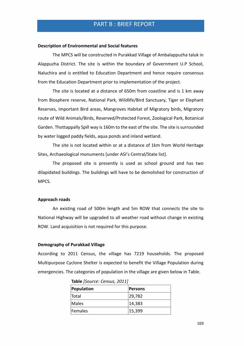
169
PART B : BRIEF REPORT
Description of Environmental and Social features
The MPCS will be constructed in Purakkad Village of Ambalappuzha taluk in
Alappuzha District. The site is within the boundary of Government U.P School,
Naluchira and is entitled to Education Department and hence require consensus
from the Education Department prior to implementation of the project.
The site is located at a distance of 650m from coastline and is 1 km away
from Biosphere reserve, National Park, Wildlife/Bird Sanctuary, Tiger or Elephant
Reserves, Important Bird areas, Mangroves Habitat of Migratory birds, Migratory
route of Wild Animals/Birds, Reserved/Protected Forest, Zoological Park, Botanical
Garden. Thottappally Spill way is 160m to the east of the site. The site is surrounded
by water logged paddy fields, aqua ponds and inland wetland.
The site is not located within or at a distance of 1km from World Heritage
Sites, Archaeological monuments [under ASI’s Central/State list].
The proposed site is presently is used as school ground and has two
dilapidated buildings. The buildings will have to be demolished for construction of
MPCS.
Approach roads
An existing road of 500m length and 5m ROW that connects the site to
National Highway will be upgraded to all weather road without change in existing
ROW. Land acquisition is not required for this purpose.
Demography of Purakkad Village
According to 2011 Census, the village has 7219 households. The proposed
Multipurpose Cyclone Shelter is expected to benefit the Village Population during
emergencies. The categories of population in the village are given below in Table.
Table [Source: Census, 2011]
Population Persons
Total 29,782
Males 14,383
Females 15,399

170
In the age group 0-6 years 2,957
Scheduled Castes (SC) 1,695
Scheduled Tribes (ST) 132
Literates 25,545
Illiterate 4,237
Total Worker 12,462
Legal Clearances
Environmental Clearance
As per EIA notification, 2006 environmental clearance is mandatory for
projects with built up area more than 20,000 sqmt. Since, the built up area of
PurakkadMPCS is only700 sqmt, project does not necessitate any environmental
clearance.
CRZ Clearance
PurakkadMPCS and approach road is 9 Km from the High Tide Line and is
outside Coast Regulation Zone. Hence, the project does not oblige to regulations as
per CRZ notification, 2011.
Forest Clearance
Since, diversion of forest area or felling of roadside plantation is not required
during any phase of construction of Purakkad MPCS and approach roads, clearance
as per Forest (Conservation) Act, 1980 is not applicable.

171
1.Aerial view of the site 2. Naluchira School premises
3. Approach road to the site 4. Dilapidated building in the site
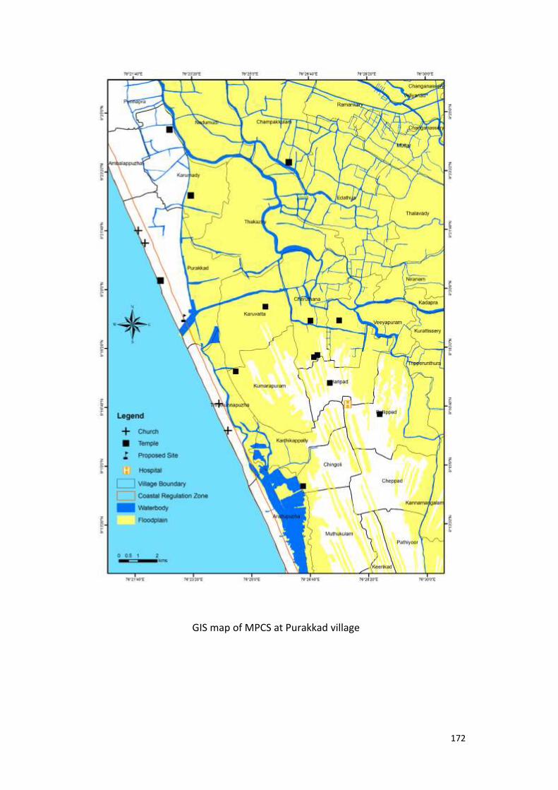
172
GIS map of MPCS at Purakkad village

173
PART C : PANCHAYATH RESOLUTION
District Alappuzha
Village Purakkad
Panchayath Purakkad Gramapanchayath
Place Purakkad
Date 06.11.2014

174
Summary of the Panchayath meeting decision:
1. The Purakkad Gramapanchayath discussed on decision taken by
Government to construct a Multi-Purpose Cyclone Shelter in Block 21,
Survey no: 50/5, Naluchira U.P School of Purakkad village.
2. The Panchayath understands that construction of MPCS would benefit the
population who are affected by floods. At present, shelters are not available for
sheltering the population.
3. A shelter that was built through funds from European Community Union is in a
dilapidated situation and is not suitable for shelter purposes exists in the site.
4. Panchayath informed that this dilapidated building can be demolished and MPCS
can be built in the site. This MPCS could serve as shelter for vulnerable population
in case of a disaster and can be used as community centre in normal times.
5. The Panchayath agrees to construct MPCS in the village. Panchayath further states
that demolition and construction should not hinder the normal school activities.
6. The Panchayath has no objection in constructing a MPCS at block no 21
survey no: 50/5 of Govt UP School, Naluchira at Purakkad village.
7. The Panchayath in decision no VI (6) dated 06/11/2014 decided to inform
the Authorities regarding the consent of the Panchayath in constructing the
Multi-Purpose Cyclone Shelter.

175
5. MPCS AT MARARIKULAM NORTH VILLAGE
PART A: ESMF CHEKLIST
Part A: General Information about the sub-project
General Information About The Sub Project
Sub Project id NCRMP/KER/ALP/ CHE/MARARIKULAM NORTH-1
Type of proposed sub-project activity MPCS
Location of the sub project activity
State Kerala
District Alappuzha
Taluk Chertahala
Village Mararikulam North
Panchayath/Municipal Corporation Marariikulam North Panchayath
Survey Number Block no: 20, Survey No: 322/6
Latitude 9⁰ 36’ 36.419”N
Longitude 76⁰ 18’ 13.091”E
Mean Sea Level 7.8 m
Size of the sub-project
Cyclone Shelter – approx. built up area 1261 SQ.M
Land requirement for the sub project (in Ha or m2)
Total Requirement
d. Private Land Nil
e. Government Land 630 SQ.M
f. Forest Land Nil
Existing Land use Fallow land with a seasonally waterlogged pit of 161 SQ.M area
Approach roads
Road name Janakshemam junction -Cheruvallisery road connects site to Mararikulam- Arthungal coastal road
Existing road Length: 100m ROW: 6m
Proposed road No approach roads proposed
Boundary wall requirement No
Part B: Ascertaining whether the site is a prohibited site PART B1: List of sites where sub-projects are prohibited
Is the sub-project located in whole or in part of any of the following environmentally sensitive areas:
Remarks if any
Biosphere reserve No
National Park No
Wildlife/Bird sanctuary No
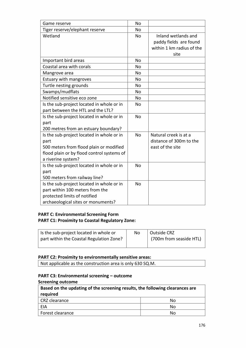
176
Game reserve No
Tiger reserve/elephant reserve No
Wetland No Inland wetlands and paddy fields are found
within 1 km radius of the site
Important bird areas No
Coastal area with corals No
Mangrove area No
Estuary with mangroves No
Turtle nesting grounds No
Swamps/mudflats No
Notified sensitive eco zone No
Is the sub-project located in whole or in part between the HTL and the LTL?
No
Is the sub-project located in whole or in part 200 metres from an estuary boundary?
No
Is the sub-project located in whole or in part 500 meters from flood plain or modified flood plain or by flood control systems of a riverine system?
No
Natural creek is at a distance of 300m to the east of the site
Is the sub-project located in whole or in part 500 meters from railway line?
No
Is the sub-project located in whole or in part within 100 meters from the protected limits of notified archaeological sites or monuments?
No
PART C: Environmental Screening Form PART C1: Proximity to Coastal Regulatory Zone:
Is the sub-project located in whole or part within the Coastal Regulation Zone?
No
Outside CRZ (700m from seaside HTL)
PART C2: Proximity to environmentally sensitive areas:
Not applicable as the construction area is only 630 SQ.M.
PART C3: Environmental screening – outcome Screening outcome
Based on the updating of the screening results, the following clearances are required
CRZ clearance No
EIA No
Forest clearance No

177
PART D: Social Screening PART D1: Identification of potential social concerns
1. Does the proposed sub-project activity require any land?
Remarks if any
Private Land (SQ.M) No
Govt. Revenue Land (SQ.M) Yes 630 SQ.M of land in ownership of Revenue Department
Forest Land (SQ.M) No
2. Does the proposed sub-project activity result in demolition/removal of existing structures?
No
Number of public structures/buildings
No
Number of common property resources (such as religious/cultural/ drinking water/wells/etc)
No
Number of private structures (located on private or public land)
No
3. Does the proposed Project activity result in loss of crops/trees which is not Government property?
Yes
4. Does the proposed Project activity result in loss of direct livelihood/ employment?
No
5. Does the proposed activity result in loss of mangrove ecosystem/social forest on which near by residents/local population are dependent for fuel wood/grazing etc.?
No
6. Does the proposed Project activity affect scheduled tribe/ caste communities?
No
Part D (2): Result/Outcome of Social Screening Exercise Outcome
Social Impact Assessment is required No
Abbreviated RAP is required No
Full RAP is required No
Details of Screening Exercise
Name Mary Midhula Maxy
Designation Environmental and Social Specialist, State Project Implementation Unit

178
PART B: BRIEF REPORT
Description of Environmental and Social features
The proposed Multipurpose Cyclone Shelter will be constructed in
Maraikulam North Village of Cherthala taluk in Alappuzha District. The proposed
land is entitled to Revenue Department.
The site is located at a distance of 700m from coastline and is 1 km away
from Biosphere reserve, National Park, Wildlife/Bird Sanctuary, Tiger or Elephant
Reserves, Important Bird areas, Mangroves Habitat of Migratory birds, Migratory
route of Wild Animals/Birds, Reserved/Protected Forest, Zoological Park, Botanical
Garden. Natural creek is at a distance of 300m to the east of the site. Inland
wetlands and paddy fields are within 1km radius of the site.
The site is not located within or at a distance of 1km from World Heritage
Sites, Archaeological monuments [under ASI’s Central/State list].
The proposed site is presently barren with a seasonally water logged pit
occupying 161sq.m area of the land. Trees need to be cut down during site
clearance.
Approach roads
The site is on the right hand side of Mararikulam-Arthungal coastal road. No
approach roads have been proposed for the MPCS.
Demography of Mararikulam North Village
According to 2011 Census, the village has 3540 households. The proposed
Multipurpose Cyclone Shelter is expected to benefit the Village Population during
emergencies. The categories of population in the village are given below in Table
Table [Source: Census, 2011]
Population Persons
Total 13,945
Male 6,860
Female 7,085
In the age group 0-6 years 1,319
Scheduled Castes (SC) 847
Scheduled Tribes (ST) 90
Literates 11,823
Illiterate 2,122
Total Worker 7,001

179
Legal Clearances
Environmental Clearance
As per EIA notification, 2006 environmental clearance is mandatory for
projects with built up area more than 20,000 sqmt. Since, the built up area of
Mararikulam NorthMPCS is only700 sqmt, project does not necessitate any
environmental clearance.
CRZ Clearance
Mararikulam North MPCS and approach road is 9 Km from the High Tide Line
and is outside Coast Regulation Zone. Hence, the project does not oblige to
regulations as per CRZ notification, 2011.
Forest Clearance
Since, diversion of forest area or felling of roadside plantation is not required
during any phase of construction of Mararikulam NorthMPCS, clearance as per
Forest (Conservation) Act, 1980 is not applicable.

180
1. Aerial map of site 2. View of site from Approach roads
3.View of the site

181
GIS map of Mararikulam North MPCS

182
PART C: PANCHAYATH RESOLUTION
District Alappuzha
Village Mararikulam North
Panchayath Mararikulam North Gramapanchayath
Place Mararikulam North
Date 24.11.2014

183
Summary of the Panchayath meeting decision:
1. Mararikulam North Gramapanchayath discussed on decision taken by
Government to construct a Multi-Purpose Cyclone Shelter in Block no: 20, Survey
No: 322/6 of Mararikulam North Village.
2. The Panchayath understands that construction of MPCS would benefit the population
who are affected by floods. At present, shelters are not available for sheltering the
population.
3. This MPCS could serve as shelter for vulnerable population in case of a disaster and can
be used as community centre in normal times.
4. The Panchayath has no objection in constructing a MPCS at Block no: 20, Survey
No: 322/6 of Mararikulam North Village
5. The Panchayath in decision no.6 dated 24/11/2014 decided to inform the
Authorities regarding the consent of the Panchayath in constructing the Multi-
Purpose Cyclone Shelter.

184
6. MPCS AT KAINAKARI NORTH VILLAGE
PART A: ESMF CHEKLIST
Part A: General Information about the sub-project
General Information About The Sub Project
Sub Project id NCRMP/KER/ALP/ KUT/KAINAKARI NORTH-1
Type of proposed sub-project activity MPCS
Location of the sub project activity
State Kerala
District Alappuzha
Taluk Kuttanad
Village Kainkari North
Panchayath/Municipal Corporation Kainkari North Panchayath
Survey Number Survey number: 65/5
Latitude 9⁰ 30' 6.63'N
Longitude 76⁰ 22' 9.26"E
Mean Sea Level 11 m
Size of the sub-project
Cyclone Shelter – approx. built up area 1200 SQ.M
Land requirement for the sub project (in Ha or m2)
Total Requirement
g. Private Land Nil
h. Government Land 900 SQ.M
i. Forest Land Nil
Existing Land use
Approach roads
Road name
Panchayath roads connect site to Changanassery- Alappuzha main road. National water way III and inland waterway connects the site to nearby towns
Existing road ROW: 2m
Proposed road No approach roads proposed
Boundary wall requirement No
Part B: Ascertaining whether the site is a prohibited site PART B1: List of sites where sub-projects are prohibited
Is the sub-project located in whole or in part of any of the following environmentally sensitive areas:
Remarks if any
Biosphere reserve No
National Park No
Wildlife/Bird sanctuary No
Game reserve No
Tiger reserve/elephant reserve No
Wetland Yes Kuttanad region is a notified Ramsar Site. Inland wetlands,

185
Paddy fields are within the 1km radius of the site
Important bird areas No
Coastal area with corals No
Mangrove area No
Estuary with mangroves No
Turtle nesting grounds No
Swamps/mudflats No
Notified sensitive eco zone - Ramsar site region
Is the sub-project located in whole or in part between the HTL and the LTL?
No
Is the sub-project located in whole or in part 200 metres from an estuary boundary?
No The site is approximately 50m away from the embankment of the Pamba river that is to the west of the site.
Is the sub-project located in whole or in part 500 meters from flood plain or modified flood plain or by flood control systems of a riverine system?
No
The proposed site falls in the floodplain region of Kuttanad Wetland system and gets water logged to a height of 75cm during rainy season. Inland wetlands and paddy fields are within 1km radius of the site.
Is the sub-project located in whole or in part 500 meters from railway line?
No
Is the sub-project located in whole or in part within 100 meters from the protected limits of notified archaeological sites or monuments?
No
PART C: Environmental Screening Form PART C1: Proximity to Coastal Regulatory Zone:
Is the sub-project located in whole or part within the Coastal Regulation Zone?
No
Outside CRZ (5km from HTL and 55m from water body)
PART C2: Proximity to environmentally sensitive areas:
Not applicable as the construction area is only 900 SQ.M.
PART C3: Environmental screening – outcome Screening outcome
Based on the updating of the screening results, the following clearances are required
CRZ clearance No
EIA No
Forest clearance No
PART D: Social Screening PART D1: Identification of potential social concerns
1. Does the proposed sub-project activity require any land? Remarks if any

186
Private Land (SQ.M) No
Govt. Revenue Land (SQ.M) Yes 900 SQ.M of land in the ownership of Education Department
Forest Land (SQ.M) No
2. Does the proposed sub-project activity result in demolition/removal of existing structures?
No
Number of public structures/buildings No
Number of common property resources (such as religious/cultural/ drinking water/wells/etc)
No
Number of private structures (located on private or public land)
No
3. Does the proposed Project activity result in loss of crops/trees which is not Government property?
Yes
4. Does the proposed Project activity result in loss of direct livelihood/ employment?
No
5. Does the proposed activity result in loss of mangrove ecosystem/social forest on which nearby residents/local population are dependent for fuel wood/grazing etc.?
No
6. Does the proposed Project activity affect scheduled tribe/ caste communities?
No
Part D (2): Result/Outcome of Social Screening Exercise Outcome
Social Impact Assessment is required No
Abbreviated RAP is required No
Full RAP is required No
Details of Screening Exercise
Name Mary Midhula Maxy
Designation Environmental and Social Specialist, State Project Implementation Unit

187
PART B: BRIEF REPORT
Description of the site
The site for MPCS is within the premises of Government school, Kuppappuram
and is entitled to Education Department. The site is located at a distance of 5km from
coastline and is located on the deltaic region of Lower Kuttanad surrounded by rivulets
of Pamba river and backwaters. The site is approximately 50m away from the
embankment of the Pamba river that is to the west of the site and the site is presently
barren. The proposed site falls in the floodplain region of Kuttanad Wetland system and
gets water logged to a height of 75cm during rainy season. Inland wetlands and paddy
fields are within 1km radius of the site.
The site is located in the Vembanad wetland system which is recognised as
Ramsar site and is declared as Critically Vulnerable Coastal Area in CRZ notification of
2011. The site is 1 km away from Biosphere reserve, National Park, Wildlife/Bird
Sanctuary, Tiger or Elephant Reserves, Important Bird areas, Mangroves Habitat of
Migratory birds, Migratory route of Wild Animals/Birds, Reserved/Protected Forest,
Zoological Park, Botanical Garden. The site is not located within or at a distance of 1km
from World Heritage Sites, Archaeological monuments [under ASI’s Central/State list].
Approach roads
Side roads from Changanassery and Alappuzha main road connect Kainakari
Panchayath to the nearby towns. The site is 200m away from the Nedumudi-
Kuppapuram road that is under construction. A bridge followed by a 2m wide untarred
Panchayath public road connects Kuppapuram and the site. The site is accessible from
major locations of Alappuzha via waterways. National Water way lll and inland
waterways connect the site to nearby towns. Two ferry ports are located near to the
site. No approach roads have been proposed for the MPCS.
Demography of Kainakari North Village
. Kainakari North village is one among the worst affected regions during floods
as most of the houses and roads remains flooded, detaching the village from nearby
towns and access to basic facilities. Kainakari Panchayath has a population of 26862 and

188
a population density of 733 people per sq.km. The population statistics of Kainakari
North village is given below in table 1. Apart from a few concrete housing structures,
most of the households are thatched huts or with tiled roof. The houses get flooded to
a level of 0.6 to 2m in certain areas during monsoon. Houses alongside the canals are
among the worst affected/damaged.
Table [Source: Census, 2011]
Population Persons
Total 8292
Male 4081
Female 4211
In the age group 0-6 years 893
Scheduled Castes (SC) 774
Scheduled Tribes (ST) 3
Literates 7238
Illiterate 1054
Worker 3554
Non Worker 4738
Legal Clearances
Environmental Clearance
As per EIA notification, 2006 environmental clearance is mandatory for projects
with built up area more than 20,000 sqmt. Since, the built up area of Kainakari North
MPCS is only 700 sqmt, project does not necessitate any environmental clearance.
CRZ Clearance
Kainakari North MPCS and approach road is 9 Km from the High Tide Line and is
outside Coast Regulation Zone. Hence, the project does not oblige to regulations as per
CRZ notification, 2011.
Forest Clearance
Since, diversion of forest area or felling of roadside plantation is not required
during any phase of construction of Kainakari North MPCS, clearance as per Forest
(Conservation) Act, 1980 is not applicable.

189
Kerala Conservation of Wetland and paddy act 2008
As per Kerala Conservation of Wetland and paddy act 2008, clearance is mandatory for
projects in wetland regions of the state. Since, the site is in notified wetland area, the
site attracts clearance from the authority.

190
1. Aerial map of the site 2. View of the site
3. Approach roads to the site (Ferry can be seen) 4. School premises

GIS map of Kainakari North MPCS

192
PART C: PANCHAYATH RESOLUTION
District Alappuzha
Village Kainakari North
Panchayath Kainkari Gramapanchayath
Place Kainkari
Date 04.03.2016

193

194
Summary of the Panchayath meeting decision:
The Panchayath meeting was attended by the following members:
1. C. Premji, Junior Superintendent, Collectorate, Alappuzha
2. Jayalal Village officer, Kainakary
3. Sebastien P J Taluk Survyer, Kuttanad
4. Biju S Deputy Tahsildar, Kuttanad
5. Amod. M .Das Village Officer, Kainakary North
6. Sunil P Pathmanabhan, Member, Kainakary Panchayath
7. Sajimol Sajiv Member, Kainakary Panchayath
8. Agnas Grigory Member, Kainakary Panchayath
9. Tintumol T M Member, Kainakary Panchayath
10. Joby Vargheese, Member, Kainakary Panchayath
11. K P Rajeev, Welfare Standing committee Chairman, Member, Kainakary Panchayath
12. R Vishakhan, PTA President,GHS Kuppapuram
13. Jijo Pallikkal, PTA Vise President,GHS Kuppapuram
14. Sushama Ajayan, Chairperson
15. Sheela K S, Headmistress, GHS Kuppapuram
16. Susheela Babu Member, Kainakary Panchayath
17. Ayshamma Jeevanandan, Member, Kainakary Panchayath
18. Subi Santhosh Health and Education committee Chairperson, Member, Kainakary
Panchayath
19. Girija Binod, Member, Kainakary Panchayath
20. Maya Devi, Member, Kainakary Panchayath
21. Sheela V.V, President , Kainakary Panchayath
22. Sabu D Secretary, Kainakary Grama Panchayath
23. Chinthumol C, Local Community Mobiliser, NCRMP Project, Alappuzha
1. Panchayath Level committee regarding construction of Cyclone shelters in the
compound of Govt High school Kuppapuram conducted on 04/03/2016 at 10.30 AM
presided by Smt Sheela V.V (Gramapanchayath President). The details of Project was
described by Sri Premji C (Superintendent, Disaster Management section, Collectorate
alappuzha) and Smt Chinthu (Local Community Mobiliser, NCRMP Project, Alappuzha).
2. During Monson season, houses and roads in Kainakari North Village remains flooded
for several weeks. Schools and community centres are used as relief camps to shelter
the vulnerable population. Students lose their academic days during these times.

195
3. The Panchayath were supported the construction of Multipurpose Cyclone shelter in site
as it will serve the purpose for sheltering large number of affected population during
flood times.
4. The MPCS would act as a common point for distribution of food and relief materials to
sheltered people and vulnerable population from nearby villages can also be
accommodated if required.
5. The committee recommended for including helipad facilities during the construction of
Multipurpose Cyclone shelter
6. It was agreed that at normal times the MPCS serve as community halls
7. The committee agreed that there are no adverse environmental and social consequences
in constructing the MPCS at site.
8. The committee meeting concluded at 11.30 a.m.
9. The decision of Kainkari Panchayath was published through resolution no: VI(1) dated
04/03/2016.

196
9. District: Kollam

197
Kollam District
Kollam district is situated on the South west coast of Kerala. The district is bound on the
north, north east and south by Alappuzha, Pathanamthitta and Thiruvananthapuram districts
respectively. To the east of Kollam is Thiruneliveli district of Tamil Nadu and to the west is
Arabian Sea. The Sasthamcotta lake, the only major fresh water lake in the state, is in Kollam
District. The district has a coastline of 37.3 km was one of the worst affected districts during
Tsunami in 2004.
The sites selected for construction of Multipurpose Cyclone shelters in Kasargod
District are at Karunagappally Village, Vadakkevila village and Thazhava village of Kasargod
District.
Profile of Kollam
Headquarters Kollam
Total Population 26,35,375
Male 12,46,968
Female 13,88,407
Population Growth 1.94%
Density/Km2 1061
Number of Taluks 6
Number of Villages 104
Number of Panchayath Wards 70
Forest Area 814.38 Km2
Average Rainfall 2,700 mm
Temperature Min: 22.4˚C
Max:36˚C
Number of major rivers 2
Major Soil Sandy loams, Laterite soil

198
Vulnerability Assessment of the District
Two rivers Kallada and Ithikkara flows through this District. The Sasthamcotta lake, the
only major fresh water lake in the state is in Kollam District. Banks of Kayamkulam Kayal and
Ashtamudi kayal area prone to flooding. The table below details the vulnerability area of the
district to various hydro-meteorological hazards.
Taluks in the
district
Flood Coastal Erosion Storm
surge/
Tsunami
inundation
Low High
Without
seawall
With sea wall
Area
km2
Area
%
Length
Km
Length
%
Length
Km
Length
%
Length
Km
Length
%
Area
km2
Area
%
Karunagappally 56.6 31.8 0.9 3.6 1.1 4.5 20.3 85.8 14.7 8.2
Kollam 72.3 18.7 - - - - 17.5 69 16.8 4.4
Kottarakara 75.3 13.6 - - - - - - - -
Kunnathur 38.5 27.6 - - - - - - - -
Pathanapuram 40.5 3.3 - - - - - - - -

199
Source: National Centre for Earth Science Studies
1. MPCS AT KARUNAGAPPALLY VILLAGE
PART A: ESMF CHECKLIST
Part A: General Information about the sub-project
Sub Project id NCRMP/KER/KLM/ KAR/
KARUNAGAPPALLY-1
Type of proposed sub-project activity MPCS
Location of the sub project activity
State Kerala
District Kollam
Taluk Karunagappally
Village Karunagappally
Panchayath/Municipal Corporation Karunagappally Municipality
Survey Number Block:10, Survey number: 582/11
Latitude 9⁰ 3' 47.85”N
Longitude 76⁰ 32' 20.85"E
Mean Sea Level 9.5 m above MSL
Size of the sub-project
Cyclone Shelter – approx. built up area 1314 SQ.M
Land requirement for the sub project (in Ha or m2)
Total Requirement
s. Private Land Nil
t. Government Land 500 SQ.M
u. Forest Land Nil
Existing Land use A dilapidated building exists in the site
Approach roads
Road name Model Polytechnic College Road
Existing road Length: 500m ROW: 5m
Proposed road No approach road proposed
Part B: Ascertaining whether the site is a prohibited site
Part B1: List of sites where sub-projects are prohibited
Is the sub-project located in whole or within any of the following
environmentally sensitive area? Remarks if any

200
Biosphere reserve No
National Park No
Wildlife/Bird sanctuary No
Game reserve No
Tiger reserve/elephant reserve No
Wetland No Paddy fields and inland
wetlands are found
within 1km radius of
the site.
Important bird areas No
Coastal area with corals No
Mangrove area No
Estuary with mangroves No
Turtle nesting grounds No
Swamps/mudflats No
Notified sensitive eco zone No
Is the sub-project located in whole or in part
between the HTL and the LTL?
No
Is the sub-project located in whole or in part 200
metres from an estuary boundary?
No
Is the sub-project located in whole or in part 500
meters from flood plain or modified flood plain or
by flood control systems of a riverine system?
No
The site is at a distance
of 1.4 km from the
Stream of Achenkoil
river.
Is the sub-project located in whole or in part 500
meters from railway line?
No The site is 507km from
the nearest railway
line.
Is the sub-project located in whole or in part within
100 meters from the protected limits of notified
archaeological sites or monuments?
No
Is the sub-project located in whole or in within 1km radius of:
Historic places that are regionally or locally
important
No
Reservoirs/Dams No
Religious Places No
Public water bodies No
PART C: Environmental Screening Form
PART C1: Proximity to Coastal Regulatory Zone:
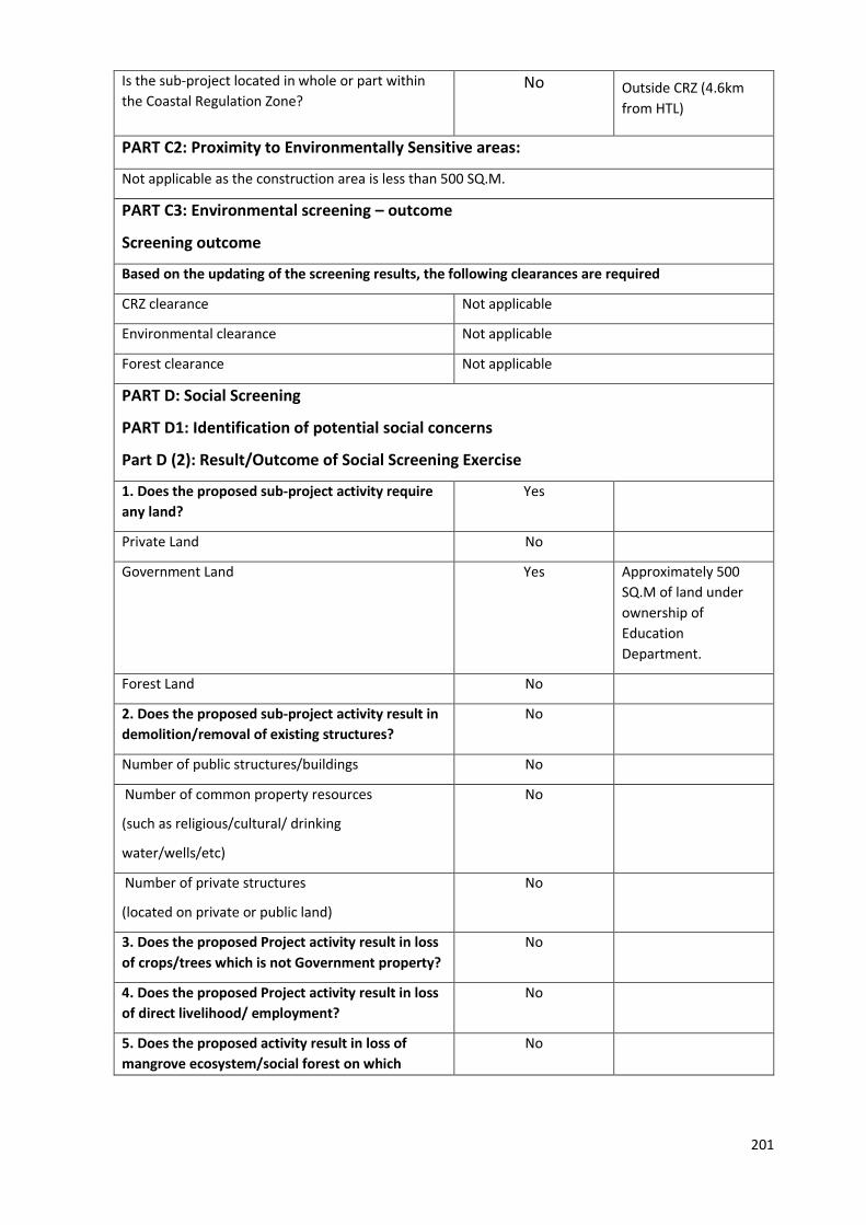
201
Is the sub-project located in whole or part within
the Coastal Regulation Zone? No
Outside CRZ (4.6km
from HTL)
PART C2: Proximity to Environmentally Sensitive areas:
Not applicable as the construction area is less than 500 SQ.M.
PART C3: Environmental screening – outcome
Screening outcome
Based on the updating of the screening results, the following clearances are required
CRZ clearance Not applicable
Environmental clearance Not applicable
Forest clearance Not applicable
PART D: Social Screening
PART D1: Identification of potential social concerns
Part D (2): Result/Outcome of Social Screening Exercise
1. Does the proposed sub-project activity require
any land?
Yes
Private Land No
Government Land Yes Approximately 500
SQ.M of land under
ownership of
Education
Department.
Forest Land No
2. Does the proposed sub-project activity result in
demolition/removal of existing structures?
No
Number of public structures/buildings No
Number of common property resources
(such as religious/cultural/ drinking
water/wells/etc)
No
Number of private structures
(located on private or public land)
No
3. Does the proposed Project activity result in loss
of crops/trees which is not Government property?
No
4. Does the proposed Project activity result in loss
of direct livelihood/ employment?
No
5. Does the proposed activity result in loss of
mangrove ecosystem/social forest on which
No

202
nearby residents/local population are dependent
for fuel wood/grazing etc.?
6. Does the proposed Project activity affect
scheduled tribe/ caste communities?
No
Outcome
Social Impact Assessment is required No
Abbreviated RAP is required No
Full RAP is required No
Details of Screening Exercise
Name Mary Midhula Maxy
Designation Environmental and Social Specialist, State
Project Implementation Unit

203
PART B: BRIEF REPORT
Description of Environmental and Social features
The site was earlier used as office of the Kallada Irrigation Project. A total area of 25
cents is available for constructing MPCS, remaining land is proposed for court complex. A
dilapidated office building exists in the proposed site which has to be demolished to facilitate
construction. The site is at a distance of 470m from National Highway and is also accessible
from Model Polytechnic College road. The site is near to Mini Civil Station of Karunagappally
and has access to all basic amenities.
The site is located at a distance of 4.6km from coastline and is 1 km away from
Biosphere reserve, National Park, Wildlife/Bird Sanctuary, Tiger or Elephant Reserves,
Important Bird areas, Mangroves Habitat of Migratory birds, Migratory route of Wild
Animals/Birds, Reserved/Protected Forest, Zoological Park, Botanical Garden. Wetlands are
found within 10km radius of the site.
The site is not located within or at a distance of 1km from World Heritage Sites,
Archaeological monuments [under ASI’s Central/State list]..
Trees will have to be cut down to clear the land for construction. Trees such as teak,
Coconut and others are growing in the site. Banana plantation was noticed on the portion of
land adjacent to nearby road. These will have to be cut down during site preparation phase.
Approach roads
Model Poly-Technic School road connects the site to National Highway. Upgradation
of existing approach road is not proposed.
Demography of Karunagappally Village
According to 2011 Census, the village has 6310 households. The proposed
Multipurpose Cyclone Shelter is expected to benefit the Village Population during
emergencies. The categories of population in the village are given below in Table.
Table [Source: Census, 2011]
Population Persons
Total 25,336

204
Male 12,219
Female 13,117
In the age group 0-6 years 2,500
Scheduled Castes (SC) 2,235
Scheduled Tribes (ST) 82
Literates 21,754
Illiterate 3,582
Worker 7,968
Non Worker 17,368
Legal Clearances
Environmental Clearance
As per EIA notification, 2006 environmental clearance is mandatory for projects with built up
area more than 20,000 sq mt. Since, the built up area of Karunagappally MPCS is only 1314 sq.mt,
project does not necessitate any Environmental clearance.
CRZ Clearance
Karunagappally MPCS is 1 km from the High Tide Line and is not within the Coast Regulation
Zone. Hence, the project does not require clearance as per CRZ notification, 2011.
Forest Clearance
Since, diversion of forest area or felling of roadside plantation is not required during any phase
of construction of Karaunagapplly MPCS clearance as per Forest (Conservation) Act, 1980 is not
applicable.
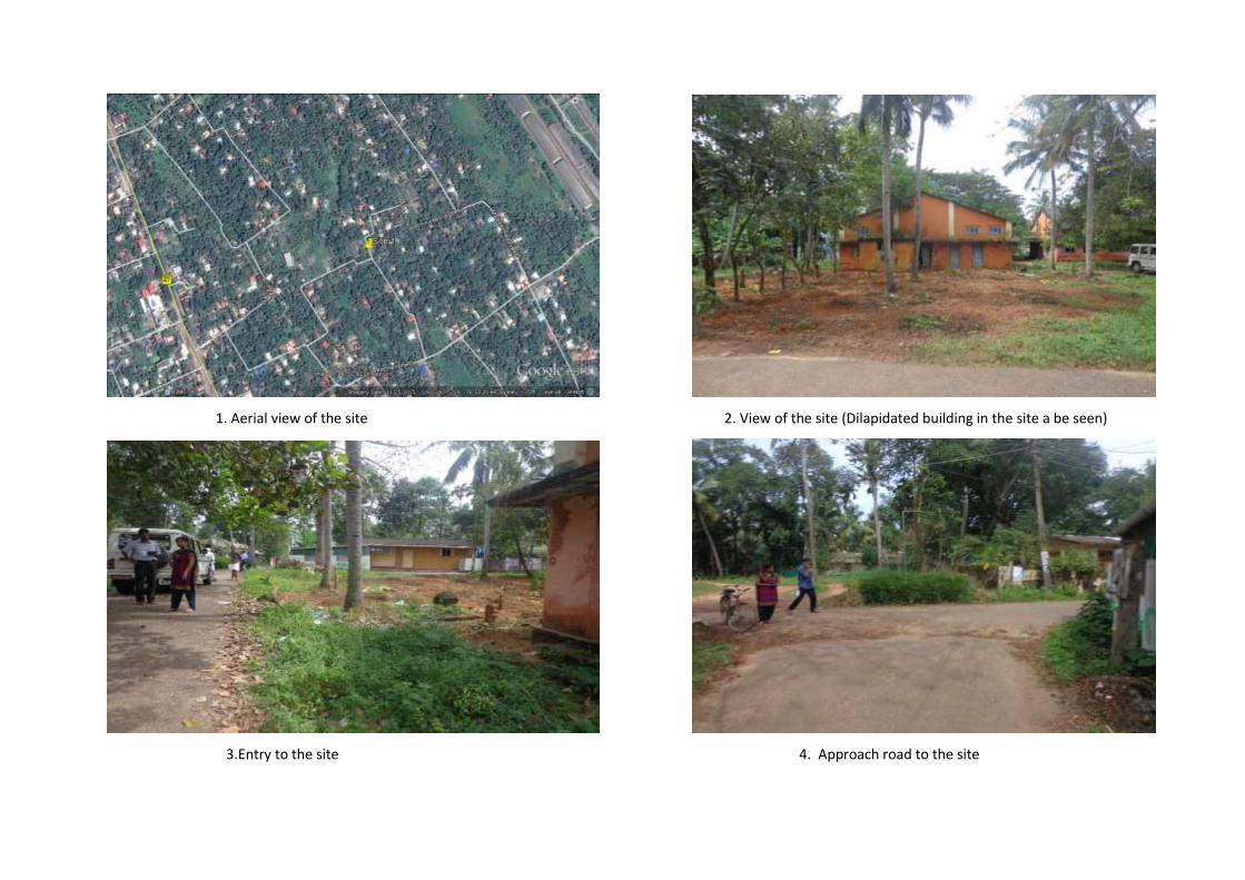
1. Aerial view of the site 2. View of the site (Dilapidated building in the site a be seen)
3.Entry to the site 4. Approach road to the site

206
GIS map of MPCS at Karunagappally Village

PART C: PANCHAYATH RESOLUTION
District Kollam
Village Karunagappally
Corporation Karunagappally Municipal Corporation
Place Karunagappally
Date 30/03/2016

208

209
Summary of the Council meeting decision:
13. The Karunagappally Municipal Council met for its session on 30/03/2016 to discuss on the
Government’s decision to construct Multi propose Cyclone Shelter at Karunagappally Village
with and to discuss reference to discuss on the request from the District Collector seeking
approval of the Local Self Governing body of Karunagappally in this regard.
14. The council in its resolution no 5(6) has agreed to the decision to construct a Multipurpose
Cyclone Shelter at Karunagappally Village adhering to the prevailing election code of conduct.

210
Part A: General Information about the sub-project
Sub Project id NCRMP/KER/ALP/ KAR/THAZHAVA-1
Type of proposed sub-project activity MPCS
Location of the sub project activity
State Kerala
District Kollam
Taluk Karunagappally
Village Thazhava
Panchayath/Municipal Corporation Thazhava Gramapanchayath
Survey Number Block:11, Survey number: 706/5
Latitude 9⁰ 5' 22.5”N
Longitude 76⁰ 33' 43.8"E
Mean Sea Level 15 m above MSL
Size of the sub-project
Cyclone Shelter – approx. built up area 1000 SQ.M
Land requirement for the sub project (in Ha or m2)
Total Requirement
v. Private Land Nil
w. Government Land 600 SQ.M
x. Forest Land Nil
Existing Land use Barren land
Approach roads
Road name
The site is accessible from main road
(Puthiyakavu-Chakkuvally road) and Panchayath
roads. The site is 3.5km east to the National
Highway.
Existing road 50m untarred road of 5m ROW connects the site to the nearby main road
Proposed road No approach road proposed
Boundary wall requirement No
Part B: Ascertaining whether the site is a prohibited site PART B1: List of sites where sub-projects are prohibited
Is the sub-project located in whole or within any of the following environmentally sensitive area?
Remarks if any
Biosphere reserve No
National Park No
Wildlife/Bird sanctuary No
Game reserve No
Tiger reserve/elephant reserve No
Wetland No
Important bird areas No
Coastal area with corals No
2. MPCS AT THAZHAVA VILLAGE
PART A: ESMF CHECKLIST

211
Mangrove area No
Estuary with mangroves No
Turtle nesting grounds No
Swamps/mudflats No
Notified sensitive eco zone No
Is the sub-project located in whole or in part between the HTL and the LTL?
No
Is the sub-project located in whole or in part 200 metres from an estuary boundary?
No
Is the sub-project located in whole or in part 500 meters from flood plain or modified flood plain or by flood control systems of a riverine system?
No
Is the sub-project located in whole or in part 500 meters from railway line?
No
Is the sub-project located in whole or in part within 100 meters from the protected limits of notified archaeological sites or monuments?
No
Is the sub-project located in whole or in within 1km radius of:
Historic places that are regionally or locally important
No
Reservoirs/Dams No
Religious Places No
Public water bodies Yes A pond exists within 200m from the site
PART C: Environmental Screening Forms PART C1: Proximity to Coastal Regulatory Zone:
Is the sub-project located in whole or part within the Coastal Regulation Zone?
No Outside CRZ ( 7.7 km from HTL)
PART C2: Proximity to Environmentally Sensitive areas:
Not applicable as the construction area is less than 1300 SQ.M.
PART C3: Environmental screening – outcome Screening outcome
Based on the updating of the screening results, the following clearances are required
CRZ clearance Not applicable
Environmental clearance Not applicable
Forest clearance Not applicable
PART D: Social Screening PART D1: Identification of potential social concerns
Does the proposed sub-project activity require any land? Remarks if any
Private Land No
212
Part D (2): Result/Outcome of Social Screening Exercise Outcome
Social Impact Assessment is required No
Abbreviated RAP is required No
Full RAP is required No
Details of Screening Exercise
Name Mary Midhula Maxy
Designation Environmental and Social Specialist, State Project Implementation Unit, NCRMP-Kerala
Government Land Yes Approximately 600 SQ.M of land under ownership of Revenue Department.
Forest Land No
2. Does the proposed sub-project activity result in demolition/removal of existing structures?
No
Number of public structures/buildings No
Number of common property resources (such as religious/cultural/ drinking water/wells/etc)
No
Number of private structures (located on private or public land)
No
3. Does the proposed Project activity result in loss of crops/trees which is not Government property?
No Number of trees:1 Species Artocarpus heterophyllus (Jack fruit tree) within Government land
4. Does the proposed Project activity result in loss of direct livelihood/ employment?
No
5. Does the proposed activity result in loss of mangrove ecosystem/social forest on which nearby residents/local population are dependent for fuel wood/grazing etc.?
No
6. Does the proposed Project activity affect scheduled tribe/ caste communities?
No
PART B: BRIEF REPORT

213
Description of Environmental and Social features
The site is a barren land within the compound of Village office of Thazhava. The site is
accessible from main road (Puthiyakavu-Chakkuvally road) and Panchayath roads. The site is
3.5km east to the National Highway. The site is around 7km from the High Tide Line. The MPCS
could be used for various purposes of the District Administration as well as training centres,
Conference rooms etc. Railway line is at a distance of 2.5km from the proposed site. Community
Health Centre, Panchayath office etc are located close to the proposed site. A pond exists within
200m from the site. The water table level in the region is good and there is no scarcity for water.
Private settlements are present near to the site. A Jackfruit tree (Artocarpus heterophyllus) has
to be cut down to clear the land for construction.
The site is located at a distance of 7.7 km from coastline and is 1 km away from Biosphere
reserve, National Park, Wildlife/Bird Sanctuary, Tiger or Elephant Reserves, Important Bird areas,
Mangroves Habitat of Migratory birds, Migratory route of Wild Animals/Birds,
Reserved/Protected Forest, Zoological Park, Botanical Garden.
The site is not located within or at a distance of 1km from World Heritage Sites,
Archaeological monuments [under ASI’s Central/State list].
Approach roads
The site is accessible from main road (Puthiyakavu-Chakkuvally road) and Panchayath
roads. The site is 3.5km east to the National Highway. Upgradation of existing approach road is
not proposed.
Demography of Thazhava Village
According to 2011 Census, the village has 5995 households. The proposed Multipurpose Cyclone
Shelter is expected to benefit the Village Population during emergencies. The categories of
population in the village are given below in Table.
Table [Source: Census, 2011]
Population Persons
Total 23,341
Male 10,818
Female 12,523
In the age group 0-6 years 2,339
Scheduled Castes (SC) 1824
Scheduled Tribes (ST) 46
Literates 19,700

214
Illiterate 3,641
Worker 7,094
Non Worker 16,247
Legal Clearances
Environmental Clearance
As per EIA notification, 2006 environmental clearance is mandatory for projects with built
up area more than 20,000 sq mt. Since, the built up area of Thazhava MPCS is only 1000 sq.mt,
project does not necessitate any Environmental clearance.
CRZ Clearance
Thazhava MPCS is 7.7 km from the High Tide Line and is not within the Coast Regulation
Zone. Hence, the project does not require clearance as per CRZ notification, 2011.
Forest Clearance
Since, diversion of forest area or felling of roadside plantation is not required during
any phase of construction of Thazhava MPCS clearance as per Forest (Conservation) Act, 1980 is
not applicable.

6. Aerial view of the site 2. View of the site (Village Office building can be seen)
3.Entry to the site 4. View of the site

GIS map of MPCS at Thazhava Village

217
District Kollam
Village Karunagappally
Panchayath Thazhava Gramapanchayath
Place Kollam
Date 04/03/2016
PART C: PANCHAYATH RESOLUTION

218
Summary of the Panchayath meeting decision:
1. The Panchayath meeting read and discussed on the letter forwarded from Kollam Collector
and the Government Order regarding the selection and in principle sanction to construct a
Multi purpose Cyclone Shelter (MPCS) at Thazhava Village.
2. The Panchayath agreed and accepted the decision of the Government to construct a MPCS at
Block no: 11, Survey no: 706/5 of Thazhava Village.
3. The Panchayath does not see any adverse environmental or social issues due to construction
of the MPCS in this site.
4. The Panchayath in its letter no: T4-1345/16 has informed its decision on this regard to District
Collector of Kollam.

219
10. District:
Thiruvananthapuram
220
Thiruvananthapuram District
Thiruvananthapuram is built on seven hills and is located at 8°30′N 76°54′E8.5°N 76.9°E on
the west coast, near the southern tip of mainland India. The city is bounded by Arabian sea in the
west with a coastline of 78 km and the Western Ghats to its east. The Geological Survey of India
has classified Thiruvananthapuram as a moderately earthquake-prone urban centre and
categorized it in the Seismic III Zone. Karamana and Killi rivers, Vellayani and Akkulam lakes are
the main water bodies in the city. Thiruvananthapuram gets majority of the rain from the south-
west monsoons and gets its first showers in early June. It also gets rain from the receding north-
east monsoons in October.
The sites selected for construction of Multipurpose Cyclone shelters in
Thiruvananthapuram District is in Muttathara village of Kasargod District.
Profile of Thiruvananthapuram
Headquarters Kudapnakkunnu
Total Population 33,07,284
Male 15,84,200
Female 17,23,084
Population Growth 2.7%
Density/Km2 1509
Number of Taluks 6
Number of Villages 121
Number of Panchayath Wards 73
Forest Area 49,861 Km2
Average Rainfall 3,500mm
Temperature Min: 23˚C, Max:38˚C
Number of major rivers 4
Major Soil
Fairly rich brown
loam of laterite, Sandy
loam
Vulnerability Assessment of the District

221
The banks of Nadayara kayal, Ayirur river, Parvathiputhanar, Ayirur ar, Ayirur ar,
Kulamada & Navaikulam, Ithikkara ar, Vilakadu, Neyyar and paddy fields are prone to flooding
during monsoon. The table below details the vulnerability area of the district to various hydro-
meteorological hazards.
Taluks in the district Flood Coastal Erosion Storm
surge/
Tsunami
inundation
Low High
Without
seawall
With sea wall
Area
km2
Area
%
Length
Km
Length
%
Length
Km
Length
%
Length
Km
Length
%
Area
km2
Area
%
Neyyatinkara 72.6 12.7 8.7 41.5 2.7 12.9 1.5 7.3 4.9 0.9
Nedumangad 68.4 7.4 - - - - - - - -
Thiruvananthapuaram 65.8 21.3 17.6 57.9 4.3 14.0 8.4 27.6 2.1 0.7
Chirayinkeezh 61.3 15.9 4.5 19.4 4.9 21.2 5.7 24.6 3.4 0.9
Source: National Centre for Earth Science Studies

222
1. MPCS AT MUTTATHARA VILLAGE
PART A: ESMF CHECKLIST
Part A: General Information about the sub-project
Sub Project id NCRMP/KER/TVM/THI/MUTTATHARA-1
Type of proposed sub-project activity MPCS
Location of the sub project activity
State Kerala
District Thiruvananthapuram
Taluk Thiruvananthapuram
Village Muttathara
Panchayath/Municipal Corporation Thiruvananthapuram Corporation
Survey Number Survey No: 2798
Latitude 8⁰27’48.5”N
Longitude 76⁰55’54.2”E
Mean Sea Level 11 m
Size of the sub-project
Cyclone Shelter – approx. built up area 1300 SQ.M
Land requirement for the sub project (in Ha or m2)
Total Requirement
y. Private Land Nil
z. Government Land 700 SQ.M
aa. Forest Land Nil
Existing Land use Barren land
Approach roads
Road name Sewage farm road
Existing road ROW: 12 m
Proposed road No approach road proposed
Boundary wall requirement No
Part B: Ascertaining whether the site is a prohibited site PART B1: List of sites where sub-projects are prohibited
Is the sub-project located in whole or within any of the following environmentally sensitive area?
Remarks if any
Biosphere reserve No
National Park No
Wildlife/Bird sanctuary No
Game reserve No
Tiger reserve/elephant reserve No
Wetland No
Important bird areas No
Coastal area with corals No
Mangrove area No

223
Estuary with mangroves No
Turtle nesting grounds No
Swamps/mudflats No
Notified sensitive eco zone No
Is the sub-project located in whole or in part between the HTL and the LTL?
No
Is the sub-project located in whole or in part 200 meters from an estuary boundary?
No
Is the sub-project located in whole or in part 500 meters from flood plain or modified flood plain or by flood control systems of a riverine system?
No
Parvathy puthan river is at a distance of 480m to the west of the site
Is the sub-project located in whole or in part 500 meters from railway line?
No
Is the sub-project located in whole or in part within 100 meters from the protected limits of notified archaeological sites or monuments?
No
Is the sub-project located in whole or in within 1km radius of:
Historic places that are regionally or locally important
No
Reservoirs/Dams No
Religious Places No
Public water bodies No
PART C: Environmental Screening Forms PART C1: Proximity to Coastal Regulatory Zone:
Is the sub-project located in whole or part within the Coastal Regulation Zone?
No Outside CRZ ( 500 m from HTL)
PART C2: Proximity to Environmentally Sensitive areas:
Not applicable as the construction area is only 700 SQ.M.
PART C3: Environmental screening – outcome Screening outcome
Based on the updating of the screening results, the following clearances are required
CRZ clearance Not applicable
Environmental clearance Not applicable
Forest clearance Not applicable
PART D: Social Screening PART D1: Identification of potential social concerns
6. Does the proposed sub-project activity require any land? Remarks if any
Private Land No

224
Part D (2): Result/Outcome of Social Screening Exercise Outcome
Social Impact Assessment is required No
Abbreviated RAP is required No
Full RAP is required No
PART B: BRIEF REPORT
Government Land Yes 700 SQ.M of land in Ownership of Revenue department
Forest Land No
2. Does the proposed sub-project activity result in demolition/removal of existing structures?
No
Number of public structures/buildings No
Number of common property resources (such as religious/cultural/ drinking water/wells/etc)
No
Number of private structures (located on private or public land)
No
3. Does the proposed Project activity result in loss of crops/trees which is not Government property?
No Coconut trees (Cocos nucifera) and Acacia trees have to be cut down to facilitate construction
4. Does the proposed Project activity result in loss of direct livelihood/ employment?
No
5. Does the proposed activity result in loss of mangrove ecosystem/social forest on which nearby residents/local population are dependent for fuel wood/grazing etc.?
No
6. Does the proposed Project activity affect scheduled tribe/ caste communities?
No
Details of Screening Exercise
Name Mary Midhula Maxy
Designation Environmental and Social Specialist, State Project Implementation Unit, NCRMP-Kerala

225
Description of Environmental and Social features
The site is near to densely populated fisherman area in Bheemappally, Valiyatura area.
The site is bordered in north by-road to fishermen area of Valiyathura, in east by Sewage farm
road in south by Sewage farm employee quarters and in west by Private house. The site has
boundary wall and a gate. A transformer is situated near to the gate. A dilapidated vehicle parking
shed and water tank exists in the site. Coconut trees and Acasia needs to be felled for site
clearance. Air force area, Airport, Sewage farm and Sewage treatment plant are all to the north
of the site and within 5km distance from the site. Mosques are at 2km radius of the site. The site
falls in CRZ and is subject to Town Planning regulations existing in Corporation area.
The site is located at a distance of 500 m from coastline and is 1 km away from Biosphere
reserve, National Park, Wildlife/Bird Sanctuary, Tiger or Elephant Reserves, Important Bird areas,
Mangroves Habitat of Migratory birds, Migratory route of Wild Animals/Birds,
Reserved/Protected Forest, Zoological Park, Botanical Garden. The site is not located within or at
a distance of 1km from World Heritage Sites, Archaeological monuments [under ASI’s
Central/State list].
The MPCS could be used for holding camps/trainings and other community functions
during normal times.
Approach roads
The site is directly accessible from Valiyathura-Sewage farm road. Upgradation of access
road is not proposed.
Demography of Muttathara Ward OF Thiruvananthapuram Corporation
According to 2011 Census, the village has 1401 households. The proposed Multipurpose
Cyclone Shelter is expected to benefit the vulnerable Population in Muttathara and nearby wars
of the corporation during emergencies. The categories of population in the village are given
below in Table. 1401
Table [Source: Census, 2011]
Population Persons

226
Total 7,714
Male 3,809
Female 3,905
In the age group 0-6 years 1,152
Scheduled Castes (SC) 205
Scheduled Tribes (ST) 30
Literates 5,606
Illiterate 2,108
Worker 2,173
Non Worker 5,541
Legal Clearances
Environmental Clearance
As per EIA notification, 2006 environmental clearance is mandatory for projects with built up area
more than 20,000 sq mt. Since, the built up area of Muttathara MPCS is only 1300 sq.mt, project does not
necessitate any Environmental clearance.
CRZ Clearance
Muttathara MPCS is 500 m from the High Tide Line and is not within the Coast Regulation Zone.
Hence, the project does not require clearance as per CRZ notification, 2011.
Forest Clearance
Since, diversion of forest area or felling of roadside plantation is not required during any phase of
construction of Muttathara MPCS clearance as per Forest (Conservation) Act, 1980 is not applicable.
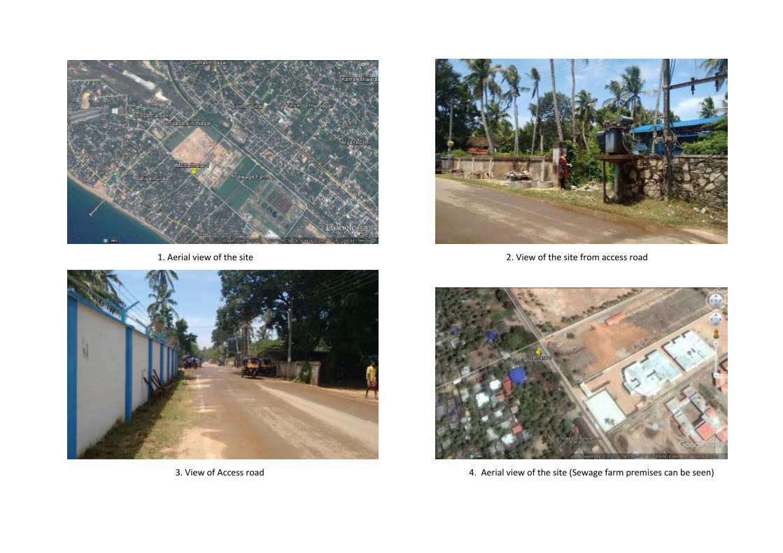
1. Aerial view of the site 2. View of the site from access road
3. View of Access road 4. Aerial view of the site (Sewage farm premises can be seen)

228
GIS map of MPCS at Muttathara Village

229
PART C: PANCHAYATH RESOLUTION
District Thiruvananthapuram
Village Muttathara
Corporation Thiruvananthapuram corporation
Place Muttathara
Date -
Note:
Resolution from Thiruvananthapuram Corporation is awaited.

230
11. ESMF Checklists of sites not selected for the project
231
1. MPCS Site Location: Government Lower primary School compound, Bare, Kasargod
Part A: General Information about the sub-project
Sub Project id NCRMP/KER/KSD/HOS/BARE-1
Type of proposed sub-project activity MPCS
Location of the sub project activity
State Kerala
District Kasargod
Taluk Hosdurg
Village Bare
Panchayath/Municipal Corporation Bare Gramapanchayath
Survey Number Survey number: 210/1A
Latitude 12⁰ 27' 27.2”N
Longitude 75⁰ 2' 12.7"E
Mean Sea Level 50 m
Size of the sub-project
Cyclone Shelter – approx. built up area 1000 SQ.M
Land requirement for the sub project (in Ha or m2)
Total Requirement
a. Private Land Nil
b. Government Land 1300 SQ.M
c. Forest Land Nil
Existing Land use Acacia Plantation
Approach roads
Road name Mangad-Chattanchal road
Existing road ROW: 20 m, Unpaved
Proposed road No approach road proposed.
Boundary wall requirement No
Part B: Ascertaining whether the site is a prohibited site PART B1: List of sites where sub-projects are prohibited
Is the sub-project located in whole or within any of the following environmentally sensitive area?
Remarks if any
Biosphere reserve No
National Park No
Wildlife/Bird sanctuary No
Game reserve No
Tiger reserve/elephant reserve No
Wetland No
Important bird areas No
Coastal area with corals No
Mangrove area No
Estuary with mangroves No
Turtle nesting grounds No
Swamps/mudflats No
Notified sensitive eco zone No

232
1. MPCS Site Location: Government Lower primary School compound, Bare, Kasargod
Is the sub-project located in whole or in part between the HTL and the LTL?
No The site is located 4km from coastline
Is the sub-project located in whole or in part 200 metres from an estuary boundary?
No
Is the sub-project located in whole or in part 500 meters from flood plain or modified flood plain or by flood control systems of a riverine system?
No
Is the sub-project located in whole or in part 500 meters from railway line?
No
Is the sub-project located in whole or in part within 100 meters from the protected limits of notified archaeological sites or monuments?
No
Is the sub-project located in whole or in within 1km radius of:
Historic places that are regionally or locally important
No
Reservoirs/Dams No
Religious Places No
Public water bodies No
PART C: Environmental Screening Forms PART C1: Proximity to Coastal Regulatory Zone:
Is the sub-project located in whole or part within the Coastal Regulation Zone?
No Outside CRZ ( 4 km from HTL)
PART C2: Proximity to Environmentally Sensitive areas:
Not applicable as the construction area is less than 1300 SQ.M.
PART C3: Environmental screening – outcome
Based on the updating of the screening results, the following clearances are required
CRZ clearance Not applicable
Environmental clearance Not applicable
Forest clearance Not applicable
PART D: Social Screening PART D1: Identification of potential social concerns
1. Does the proposed sub-project activity require any land? Remarks if any
Private Land No
Government Land Yes Approximately 1000 SQ.M of land under ownership of Education Department.
Forest Land No
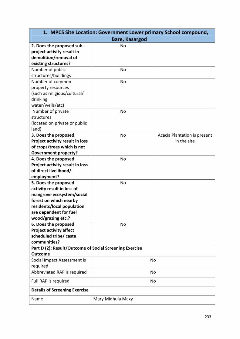
233
1. MPCS Site Location: Government Lower primary School compound, Bare, Kasargod
2. Does the proposed sub-project activity result in demolition/removal of existing structures?
No
Number of public structures/buildings
No
Number of common property resources (such as religious/cultural/ drinking water/wells/etc)
No
Number of private structures (located on private or public land)
No
3. Does the proposed Project activity result in loss of crops/trees which is not Government property?
No Acacia Plantation is present in the site
4. Does the proposed Project activity result in loss of direct livelihood/ employment?
No
5. Does the proposed activity result in loss of mangrove ecosystem/social forest on which nearby residents/local population are dependent for fuel wood/grazing etc.?
No
6. Does the proposed Project activity affect scheduled tribe/ caste communities?
No
Part D (2): Result/Outcome of Social Screening Exercise Outcome
Social Impact Assessment is required
No
Abbreviated RAP is required No
Full RAP is required No
Details of Screening Exercise
Name Mary Midhula Maxy

234
1. MPCS Site Location: Government Lower primary School compound, Bare, Kasargod
Designation Environmental and Social Specialist, State Project Implementation Unit, NCRMP-Kerala

235
2. MPCS Site Location: Revenue land, Kanhangad Part A: General Information about the sub-project
Sub Project id NCRMP/KER/KSD/ HOS/HOSDURG-1
Type of proposed sub-project activity MPCS
Location of the sub project activity
State Kerala
District Kasargod
Taluk Hosdurg
Village Hosdurg
Panchayath/Municipal Corporation Kanhangad Municipal Corporation
Survey Number Survey number: 204/1A,1A,1A,1A,1A
Latitude 12⁰ 18' 47.2”N
Longitude 75⁰ 5' 27.5"E
Mean Sea Level 25 m
Size of the sub-project
Cyclone Shelter – approx. built up area
Land requirement for the sub project (in Ha or m2)
Total Requirement
a. Private Land Nil
b. Government Land 1000 SQ.M
c. Forest Land Nil
Existing Land use A temporary vehicle parking shed exists in the site
Approach roads
Road name National Highway
Existing road -
Proposed road No approach road proposed.
Boundary wall requirement No
Part B: Ascertaining whether the site is a prohibited site PART B1: List of sites where sub-projects are prohibited
Is the sub-project located in whole or within any of the following environmentally sensitive area?
Remarks if any
Biosphere reserve No
National Park No
Wildlife/Bird sanctuary No
Game reserve No
Tiger reserve/elephant reserve No
Wetland No
Important bird areas No
Coastal area with corals No
Mangrove area No
Estuary with mangroves No
Turtle nesting grounds No
Swamps/mudflats No
Notified sensitive eco zone No

236
2. MPCS Site Location: Revenue land, Kanhangad Is the sub-project located in whole or in part between the HTL and the LTL?
No
Is the sub-project located in whole or in part 200 metres from an estuary boundary?
No
Is the sub-project located in whole or in part 500 meters from flood plain or modified flood plain or by flood control systems of a riverine system?
No
Is the sub-project located in whole or in part 500 meters from railway line?
Yes The site is 280m west to the railway line
Is the sub-project located in whole or in part within 100 meters from the protected limits of notified archaeological sites or monuments?
No
Is the sub-project located in whole or in within 1km radius of:
Historic places that are regionally or locally important
No
Reservoirs/Dams No
Religious Places No
Public water bodies No
PART C: Environmental Screening Forms PART C1: Proximity to Coastal Regulatory Zone:
Is the sub-project located in whole or part within the Coastal Regulation Zone?
No Outside CRZ ( 1 km from HTL)
PART C2: Proximity to Environmentally Sensitive areas:
Not applicable as the construction area is 1000 SQ.M.
PART C3: Environmental screening – outcome
Based on the updating of the screening results, the following clearances are required
CRZ clearance Not applicable
Environmental clearance Not applicable
Forest clearance Not applicable
PART D: Social Screening PART D1: Identification of potential social concerns
1.Does the proposed sub-project activity require any land? Remarks if any
Private Land No
Government Land Yes Approximately 1000 SQ.M of land under ownership of Revenue Department.

237
2. MPCS Site Location: Revenue land, Kanhangad Forest Land No
2. Does the proposed sub-project activity result in demolition/removal of existing structures?
Yes
Number of public structures/buildings 1 (One) One vehicle parking shed
Number of common property resources (such as religious/cultural/ drinking water/wells/etc)
No
Number of private structures (located on private or public land)
No
3. Does the proposed Project activity result in loss of crops/trees which is not Government property?
No
4. Does the proposed Project activity result in loss of direct livelihood/ employment?
No
5. Does the proposed activity result in loss of mangrove ecosystem/social forest on which nearby residents/local population are dependent for fuel wood/grazing etc.?
No
6. Does the proposed Project activity affect scheduled tribe/ caste communities?
No
Part D (2): Result/Outcome of Social Screening Exercise Outcome
Social Impact Assessment is required No
Abbreviated RAP is required No
Full RAP is required No
Details of Screening Exercise
Name Mary Midhula Maxy
Designation Environmental and Social Specialist, State Project Implementation Unit, NCRMP-Kerala

238
3. MPCS Site Location: Maicha, Cheruvathur Part A: General Information about the sub-project Sub Project id NCRMP/KER/KSD/ HOS/CHERUVATHUR-1
Type of proposed sub-project activity MPCS
Location of the sub project activity
State Kerala
District Kasargod
Taluk Hosdurg
Village Cheruvathur
Panchayath/Municipal Corporation Cheruvathur Gramapanchayath
Survey Number Survey number: 336
Latitude 12⁰ 13' 59.1”N
Longitude 7⁰ 59' 38.3"E
Mean Sea Level 45 m
Size of the sub-project
Cyclone Shelter – approx. built up area Nil
Land requirement for the sub project (in Ha or m2)
Total Requirement
a. Private Land Nil
b. Government Land Area not available
c. Forest Land Nil
Existing Land use Dilapidated shelters exists in the site
Approach roads
Road name Veeramalakunnu road
Existing road ROW: 8 m
Proposed road No approach road proposed
Boundary wall requirement No
Part B: Ascertaining whether the site is a prohibited site PART B1: List of sites where sub-projects are prohibited
Is the sub-project located in whole or within any of the following environmentally sensitive area?
Remarks if any
Biosphere reserve No
National Park No
Wildlife/Bird sanctuary No
Game reserve No
Tiger reserve/elephant reserve No
Wetland No
Important bird areas No
Coastal area with corals No
Mangrove area No
Estuary with mangroves No
Turtle nesting grounds No
Swamps/mudflats No
Notified sensitive eco zone No
Is the sub-project located in whole or in part between the HTL and the LTL?
No

239
3. MPCS Site Location: Maicha, Cheruvathur Is the sub-project located in whole or in part 200 metres from an estuary boundary?
No
Is the sub-project located in whole or in part 500 meters from flood plain or modified flood plain or by flood control systems of a riverine system?
Yes
The site is 360m to the south of Thejaswini river
Is the sub-project located in whole or in part 500 meters from railway line?
No
Is the sub-project located in whole or in part within 100 meters from the protected limits of notified archaeological sites or monuments?
No
Is the sub-project located in whole or in within 1km radius of:
Historic places that are regionally or locally important
No
Reservoirs/Dams No
Religious Places No
Public water bodies No
PART C: Environmental Screening Forms PART C1: Proximity to Coastal Regulatory Zone
Is the sub-project located in whole or part within the Coastal Regulation Zone?
No Outside CRZ ( 4 km from HTL)
PART C2: Proximity to Environmentally Sensitive areas:
Not applicable as adequate area is not available for construction of MPCS
PART C3: Environmental screening – outcome
Based on the updating of the screening results, the following clearances are required
CRZ clearance Not applicable
Environmental clearance Not applicable
Forest clearance Not applicable
PART D: Social Screening PART D1: Identification of potential social concerns
Does the proposed sub-project activity require any land?
Remarks if any
Private Land No
Government Land Yes Adequate area is not available for construction of MPCS as dilapidated shelters exists in the site
Forest Land No

240
3. MPCS Site Location: Maicha, Cheruvathur 2. Does the proposed sub-project activity result in demolition/removal of existing structures?
No
Number of public structures/buildings 2 (Two) Two dilapidated structures exists in
the site
Number of common property resources (such as religious/cultural/ drinking water/wells/etc)
No
Number of private structures (located on private or public land)
No
3. Does the proposed Project activity result in loss of crops/trees which is not Government property?
No
4. Does the proposed Project activity result in loss of direct livelihood/ employment?
No
5. Does the proposed activity result in loss of mangrove ecosystem/social forest on which nearby residents/local population are dependent for fuel wood/grazing etc.?
No
6. Does the proposed Project activity affect scheduled tribe/ caste communities?
No
Part D (2): Result/Outcome of Social Screening Exercise Outcome
Social Impact Assessment is required No
Abbreviated RAP is required No
Full RAP is required No
Details of Screening Exercise
Name Mary Midhula Maxy
Designation Environmental and Social Specialist, State Project Implementation Unit, NCRMP-Kerala

241
4. MPCS Site Location: Government Upper Primary School, Cheruvathur Part A: General Information about the sub-project Sub Project id NCRMP/KER/KSD/HOS/CHERUVATHUR-2
Type of proposed sub-project activity MPCS
Location of the sub project activity
State Kerala
District Kasargod
Taluk Hosdurg
Village Cheruvathur
Panchayath/Municipal Corporation Cheruvathur Gramapanchayath
Survey Number Survey number: 451/5
Latitude 12⁰ 12' 35.6”N
Longitude 75⁰ 9' 13.4"E
Mean Sea Level 20 m
Size of the sub-project
Cyclone Shelter – approx. built up area
Land requirement for the sub project (in Ha or m2)
Total Requirement
a. Private Land Nil
b. Government Land No area available
c. Forest Land Nil
Existing Land use School building exists in the site
Approach roads
Road name Cheruvathur-Padne-Edakkal road
Existing road ROW: 10 m
Proposed road No approach road proposed
Boundary wall requirement No
Part B: Ascertaining whether the site is a prohibited site PART B1: List of sites where sub-projects are prohibited
Is the sub-project located in whole or within any of the following environmentally sensitive area?
Remarks if any
Biosphere reserve No
National Park No
Wildlife/Bird sanctuary No
Game reserve No
Tiger reserve/elephant reserve No
Wetland No
Important bird areas No
Coastal area with corals No
Mangrove area No
Estuary with mangroves No
Turtle nesting grounds No
Swamps/mudflats No
Notified sensitive eco zone No
Is the sub-project located in whole or in part between the HTL and the LTL?
No

242
4. MPCS Site Location: Government Upper Primary School, Cheruvathur Is the sub-project located in whole or in part 200 metres from an estuary boundary?
No
Is the sub-project located in whole or in part 500 meters from flood plain or modified flood plain or by flood control systems of a riverine system?
No
The site is 2.4 km from the backwaters
Is the sub-project located in whole or in part 500 meters from railway line?
No
Is the sub-project located in whole or in part within 100 meters from the protected limits of notified archaeological sites or monuments?
No
Is the sub-project located in whole or in within 1km radius of:
Historic places that are regionally or locally important
No
Reservoirs/Dams No
Religious Places No
Public water bodies No
PART C: Environmental Screening Forms PART C1: Proximity to Coastal Regulatory Zone:
Is the sub-project located in whole or part within the Coastal Regulation Zone?
No Outside CRZ ( 3 km from HTL)
PART C2: Proximity to Environmentally Sensitive areas:
Not applicable as adequate area is not available for construction
PART C3: Environmental screening – outcome
Based on the updating of the screening results, the following clearances are required
CRZ clearance Not applicable
Environmental clearance Not applicable
Forest clearance Not applicable
PART D: Social Screening PART D1: Identification of potential social concerns
Does the proposed sub-project activity require any land? Remarks if any
Private Land No
Government Land Yes Adequate area not available for construction of MPCS
Forest Land No
2. Does the proposed sub-project activity result in demolition/removal of existing structures?
No

243
4. MPCS Site Location: Government Upper Primary School, Cheruvathur Number of public structures/buildings
No
Number of common property resources (such as religious/cultural/ drinking water/wells/etc)
No
Number of private structures (located on private or public land)
No
3. Does the proposed Project activity result in loss of crops/trees which is not Government property?
No
4. Does the proposed Project activity result in loss of direct livelihood/ employment?
No
5. Does the proposed activity result in loss of mangrove ecosystem/social forest on which nearby residents/local population are dependent for fuel wood/grazing etc.?
No
6. Does the proposed Project activity affect scheduled tribe/ caste communities?
No
Part D (2): Result/Outcome of Social Screening Exercise Outcome
Social Impact Assessment is required
No
Abbreviated RAP is required No
Full RAP is required No
Details of Screening Exercise
Name Mary Midhula Maxy
Designation Environmental and Social Specialist, State Project Implementation Unit, NCRMP-Kerala

244
5. MPCS Site Location: Government Upper Primary School, Neerchal Part A: General Information about the sub-project Sub Project id NCRMP/KER/KNR/ KAN/KANNUR-1-3
Type of proposed sub-project activity MPCS
Location of the sub project activity
State Kerala
District Kannur
Taluk Kannur
Village Kannur-1
Panchayath/Municipal Corporation Kannur Corporation
Survey Number Ward 6, Block 6, Survey number: T.S 327
Latitude 11⁰ 51' 31.5”N
Longitude 75⁰ 23' 9.8"E
Mean Sea Level 25 m
Size of the sub-project
Cyclone Shelter – approx. built up area No area available for construction of MPCS
Land requirement for the sub project (in Ha or m2)
Total Requirement
a. Private Land Nil
b. Government Land Less than 400 SQ.M
c. Forest Land Nil
Existing Land use Barren land, School ground
Approach roads
Road name Neerchal School road- Kannur city road
Existing road ROW: 6 m
Proposed road No approach road proposed
Boundary wall requirement No
Part B: Ascertaining whether the site is a prohibited site PART B1: List of sites where sub-projects are prohibited
Is the sub-project located in whole or within any of the following environmentally sensitive area?
Remarks if any
Biosphere reserve No
National Park No
Wildlife/Bird sanctuary No
Game reserve No
Tiger reserve/elephant reserve No
Wetland No
Important bird areas No
Coastal area with corals No
Mangrove area No
Estuary with mangroves No
Turtle nesting grounds No
Swamps/mudflats No
Notified sensitive eco zone No
Is the sub-project located in whole or in part between the HTL and the LTL?
No

245
5. MPCS Site Location: Government Upper Primary School, Neerchal Is the sub-project located in whole or in part 200 metres from an estuary boundary?
No
Is the sub-project located in whole or in part 500 meters from flood plain or modified flood plain or by flood control systems of a riverine system?
No
Is the sub-project located in whole or in part 500 meters from railway line?
No
Is the sub-project located in whole or in part within 100 meters from the protected limits of notified archaeological sites or monuments?
No
Is the sub-project located in whole or in within 1km radius of:
Historic places that are regionally or locally important
No
Reservoirs/Dams No
Religious Places No
Public water bodies No
PART C: Environmental Screening Forms PART C1: Proximity to Coastal Regulatory Zone:
Is the sub-project located in whole or part within the Coastal Regulation Zone?
Yes Outside CRZ ( 300 m from HTL)
PART C2: Proximity to Environmentally Sensitive areas:
Not applicable as the construction area is only 400 SQ.M.
PART C3: Environmental screening – outcome
Based on the updating of the screening results, the following clearances are required
CRZ clearance Not applicable
Environmental clearance Not applicable
Forest clearance Not applicable
PART D: Social Screening PART D1: Identification of potential social concerns
Does the proposed sub-project activity require any land?
Remarks if any
Private Land No
Government Land Yes Approximately 400 SQ.M of land under ownership of Education Department.
Forest Land No
2. Does the proposed sub-project activity result in demolition/removal of existing structures?
No

246
5. MPCS Site Location: Government Upper Primary School, Neerchal Number of public structures/buildings
No
Number of common property resources (such as religious/cultural/ drinking water/wells/etc)
No
Number of private structures (located on private or public land)
No
3. Does the proposed Project activity result in loss of crops/trees which is not Government property?
No
4. Does the proposed Project activity result in loss of direct livelihood/ employment?
No
5. Does the proposed activity result in loss of mangrove ecosystem/social forest on which nearby residents/local population are dependent for fuel wood/grazing etc.?
No
6. Does the proposed Project activity affect scheduled tribe/ caste communities?
No
Part D (2): Result/Outcome of Social Screening Exercise Outcome
Social Impact Assessment is required
No
Abbreviated RAP is required No
Full RAP is required No
Details of Screening Exercise
Name Mary Midhula Maxy
Designation Environmental and Social Specialist, State Project Implementation Unit, NCRMP-Kerala

247
6. MPCS Site Location: Government Higher Secondary School, Muzhupilangad
Part A: General Information about the sub-project Sub Project id NCRMP/KER/KNR/KAN/MUZHUPILANGAD-1
Type of proposed sub-project activity MPCS
Location of the sub project activity
State Kerala
District Kannur
Taluk Kannur
Village Muzhupilnagad
Panchayath/Municipal Corporation Muzhupilangad Gramapanchayath
Survey Number Survey number: 105/9
Latitude 11⁰ 47' 55.2”N
Longitude 75⁰ 27' 23.4"E
Mean Sea Level 35 m
Size of the sub-project
Cyclone Shelter – approx. built up area No area available for construction
Land requirement for the sub project (in Ha or m2)
Total Requirement
a. Private Land Nil
b. Government Land No area available for construction
c. Forest Land Nil
Existing Land use School ground
Approach roads
Road name Muzupilnagad road
Existing road ROW: 6 m
Proposed road No approach road proposed.
Boundary wall requirement No
Part B: Ascertaining whether the site is a prohibited site PART B1: List of sites where sub-projects are prohibited
Is the sub-project located in whole or within any of the following environmentally sensitive area?
Remarks if any
Biosphere reserve No
National Park No
Wildlife/Bird sanctuary No
Game reserve No
Tiger reserve/elephant reserve No
Wetland No
Important bird areas No
Coastal area with corals No
Mangrove area No
Estuary with mangroves No
Turtle nesting grounds No
Swamps/mudflats No
Notified sensitive eco zone No
Is the sub-project located in whole or in part between the HTL and the LTL?
No

248
6. MPCS Site Location: Government Higher Secondary School, Muzhupilangad
Is the sub-project located in whole or in part 200 metres from an estuary boundary?
No
Is the sub-project located in whole or in part 500 meters from flood plain or modified flood plain or by flood control systems of a riverine system?
No
Is the sub-project located in whole or in part 500 meters from railway line?
No
Is the sub-project located in whole or in part within 100 meters from the protected limits of notified archaeological sites or monuments?
No
Is the sub-project located in whole or in within 1km radius of:
Historic places that are regionally or locally important
No
Reservoirs/Dams No
Religious Places No
Public water bodies No
PART C: Environmental Screening Forms PART C1: Proximity to Coastal Regulatory Zone:
Is the sub-project located in whole or part within the Coastal Regulation Zone?
No Outside CRZ ( 1.4 km from HTL)
PART C2: Proximity to Environmentally Sensitive areas:
Not applicable as the construction area is less than 1300 SQ.M.
PART C3: Environmental screening – outcome
Based on the updating of the screening results, the following clearances are required
CRZ clearance Not applicable
Environmental clearance Not applicable
Forest clearance Not applicable
PART D: Social Screening PART D1: Identification of potential social concerns
Does the proposed sub-project activity require any land?
Remarks if any
Private Land No
Government Land Yes Approximately 500 SQ.M of land under ownership of Revenue Department.
Forest Land No
2. Does the proposed sub-project activity result in demolition/removal of existing structures?
No
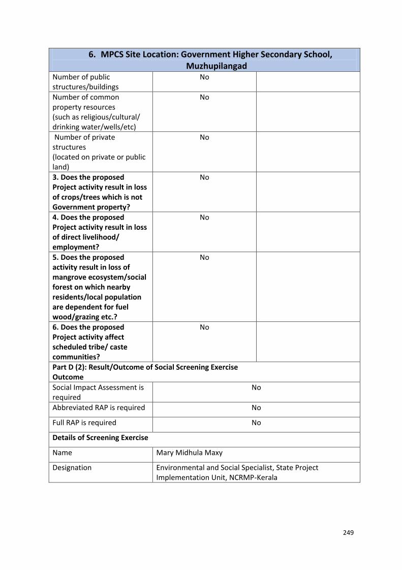
249
6. MPCS Site Location: Government Higher Secondary School, Muzhupilangad
Number of public structures/buildings
No
Number of common property resources (such as religious/cultural/ drinking water/wells/etc)
No
Number of private structures (located on private or public land)
No
3. Does the proposed Project activity result in loss of crops/trees which is not Government property?
No
4. Does the proposed Project activity result in loss of direct livelihood/ employment?
No
5. Does the proposed activity result in loss of mangrove ecosystem/social forest on which nearby residents/local population are dependent for fuel wood/grazing etc.?
No
6. Does the proposed Project activity affect scheduled tribe/ caste communities?
No
Part D (2): Result/Outcome of Social Screening Exercise Outcome
Social Impact Assessment is required
No
Abbreviated RAP is required No
Full RAP is required No
Details of Screening Exercise
Name Mary Midhula Maxy
Designation Environmental and Social Specialist, State Project Implementation Unit, NCRMP-Kerala

250
7. MPCS Site Location: Revenue land, Thalassery Part A: General Information about the sub-project Sub Project id NCRMP/KER/KNR/THA/THALASSERY-1
Type of proposed sub-project activity MPCS
Location of the sub project activity
State Kerala
District Kannur
Taluk Thalassery
Village Thalassery
Panchayath/Municipal Corporation Thalassery Municipal Corporation
Survey Number Ward no: 5, Block 7, T.S:112
Latitude 11⁰ 45' 10.2”N
Longitude 75⁰ 29' 6.6"E
Mean Sea Level 15 m
Size of the sub-project
Cyclone Shelter – approx. built up area No area available for construction of MPCS
Land requirement for the sub project (in Ha or m2)
Total Requirement
a. Private Land Nil
b. Government Land No area available for construction of MPCS
c. Forest Land Nil
Existing Land use Barren land
Approach roads
Road name National Highway
Existing road -
Proposed road No approach road proposed
Boundary wall requirement No
Part B: Ascertaining whether the site is a prohibited site PART B1: List of sites where sub-projects are prohibited
Is the sub-project located in whole or within any of the following environmentally sensitive area?
Remarks if any
Biosphere reserve No
National Park No
Wildlife/Bird sanctuary No
Game reserve No
Tiger reserve/elephant reserve No
Wetland No
Important bird areas No
Coastal area with corals No
Mangrove area No
Estuary with mangroves No
Turtle nesting grounds No
Swamps/mudflats No
Notified sensitive eco zone No
Is the sub-project located in whole or in part between the HTL and the LTL?
No
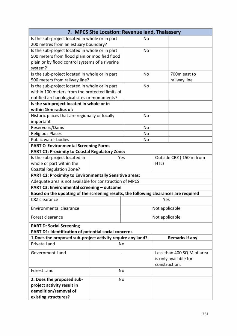
251
7. MPCS Site Location: Revenue land, Thalassery Is the sub-project located in whole or in part 200 metres from an estuary boundary?
No
Is the sub-project located in whole or in part 500 meters from flood plain or modified flood plain or by flood control systems of a riverine system?
No
Is the sub-project located in whole or in part 500 meters from railway line?
No 700m east to railway line
Is the sub-project located in whole or in part within 100 meters from the protected limits of notified archaeological sites or monuments?
No
Is the sub-project located in whole or in within 1km radius of:
Historic places that are regionally or locally important
No
Reservoirs/Dams No
Religious Places No
Public water bodies No
PART C: Environmental Screening Forms PART C1: Proximity to Coastal Regulatory Zone:
Is the sub-project located in whole or part within the Coastal Regulation Zone?
Yes Outside CRZ ( 150 m from HTL)
PART C2: Proximity to Environmentally Sensitive areas:
Adequate area is not available for construction of MPCS
PART C3: Environmental screening – outcome
Based on the updating of the screening results, the following clearances are required
CRZ clearance Yes
Environmental clearance Not applicable
Forest clearance Not applicable
PART D: Social Screening PART D1: Identification of potential social concerns
1.Does the proposed sub-project activity require any land? Remarks if any
Private Land No
Government Land - Less than 400 SQ.M of area is only available for construction.
Forest Land No
2. Does the proposed sub-project activity result in demolition/removal of existing structures?
No

252
7. MPCS Site Location: Revenue land, Thalassery Number of public structures/buildings
No
Number of common property resources (such as religious/cultural/ drinking water/wells/etc)
No
Number of private structures (located on private or public land)
No
3. Does the proposed Project activity result in loss of crops/trees which is not Government property?
No
4. Does the proposed Project activity result in loss of direct livelihood/ employment?
No
5. Does the proposed activity result in loss of mangrove ecosystem/social forest on which nearby residents/local population are dependent for fuel wood/grazing etc.?
No
6. Does the proposed Project activity affect scheduled tribe/ caste communities?
No
Part D (2): Result/Outcome of Social Screening Exercise Outcome
Social Impact Assessment is required
No
Abbreviated RAP is required No
Full RAP is required No
Details of Screening Exercise
Name Mary Midhula Maxy
Designation Environmental and Social Specialist, State Project Implementation Unit, NCRMP-Kerala

253
8. MPCS Site Location: Revenue land, Thalassery Part A: General Information about the sub-project Sub Project id NCRMP/KER/KNR/THA/THALASSERY-2
Type of proposed sub-project activity MPCS
Location of the sub project activity
State Kerala
District Kannur
Taluk Thalassery
Village Thalassery
Panchayath/Municipal Corporation Thalassery Municipal Corporation
Survey Number Ward no 5, Block 10, T.S 169/1
Latitude 11⁰ 44' 57.2”N
Longitude 75⁰ 29' 9.6"E
Mean Sea Level 17 m
Size of the sub-project
Cyclone Shelter – approx. built up area 900 SQ.M
Land requirement for the sub project (in Ha or m2)
Total Requirement
a. Private Land Nil
b. Government Land 500 SQ.M
c. Forest Land Nil
Existing Land use -
Approach roads
Road name National Highway
Existing road -
Proposed road No approach road proposed
Boundary wall requirement No
Part B: Ascertaining whether the site is a prohibited site PART B1: List of sites where sub-projects are prohibited
Is the sub-project located in whole or within any of the following environmentally sensitive area?
Remarks if any
Biosphere reserve No
National Park No
Wildlife/Bird sanctuary No
Game reserve No
Tiger reserve/elephant reserve No
Wetland No
Important bird areas No
Coastal area with corals No
Mangrove area No
Estuary with mangroves No
Turtle nesting grounds No
Swamps/mudflats No
Notified sensitive eco zone No
Is the sub-project located in whole or in part between the HTL and the LTL?
No

254
8. MPCS Site Location: Revenue land, Thalassery Is the sub-project located in whole or in part 200 metres from an estuary boundary?
No
Is the sub-project located in whole or in part 500 meters from flood plain or modified flood plain or by flood control systems of a riverine system?
No
Is the sub-project located in whole or in part 500 meters from railway line?
No
Is the sub-project located in whole or in part within 100 meters from the protected limits of notified archaeological sites or monuments?
Yes Thalassery Kotta is within a distance of 150m from the site.
Is the sub-project located in whole or in within 1km radius of:
Historic places that are regionally or locally important
No
Reservoirs/Dams No
Religious Places No
Public water bodies No
PART C: Environmental Screening Forms PART C1: Proximity to Coastal Regulatory Zone:
Is the sub-project located in whole or part within the Coastal Regulation Zone?
No Within CRZ ( 200 m from HTL)
PART C2: Proximity to Environmentally Sensitive areas:
Not applicable as the construction area is only 1000 SQ.M.
PART C3: Environmental screening – outcome
Based on the updating of the screening results, the following clearances are required
CRZ clearance Yes
Environmental clearance Not applicable
Forest clearance Not applicable
PART D: Social Screening PART D1: Identification of potential social concerns
Does the proposed sub-project activity require any land? Remarks if any
Private Land No
Government Land Yes Approximately 500 SQ.M of land under ownership of Revenue Department.
Forest Land No
2. Does the proposed sub-project activity result in demolition/removal of existing structures?
No

255
8. MPCS Site Location: Revenue land, Thalassery Number of public structures/buildings
No
Number of common property resources (such as religious/cultural/ drinking water/wells/etc)
No
Number of private structures (located on private or public land)
No
3. Does the proposed Project activity result in loss of crops/trees which is not Government property?
No
4. Does the proposed Project activity result in loss of direct livelihood/ employment?
No
5. Does the proposed activity result in loss of mangrove ecosystem/social forest on which nearby residents/local population are dependent for fuel wood/grazing etc.?
No
6. Does the proposed Project activity affect scheduled tribe/ caste communities?
No
Part D (2): Result/Outcome of Social Screening Exercise Outcome
Social Impact Assessment is required
No
Abbreviated RAP is required No
Full RAP is required No
Details of Screening Exercise
Name Mary Midhula Maxy
Designation Environmental and Social Specialist, State Project Implementation Unit, NCRMP-Kerala

256
9. MPCS Site Location: Revenue land, Thalassery Part A: General Information about the sub-project Sub Project id NCRMP/KER/KNR/THA/THALASSERY-3
Type of proposed sub-project activity MPCS
Location of the sub project activity
State Kerala
District Kannur
Taluk Thalassery
Village Thalassery
Panchayath/Municipal Corporation Thalassery Municipal Corporation
Survey Number Ward no 5, Block 10, T.S 172/2A
Latitude 11⁰ 44' 58.4”N
Longitude 75⁰ 29' 10.7"E
Mean Sea Level 17 m
Size of the sub-project
Cyclone Shelter – approx. built up area 900 SQ.M
Land requirement for the sub project (in Ha or m2)
Total Requirement
a. Private Land Nil
b. Government Land 500 SQ.M
c. Forest Land Nil
Existing Land use -
Approach roads
Road name National Highway
Existing road -
Proposed road No approach road proposed
Boundary wall requirement No
Part B: Ascertaining whether the site is a prohibited site PART B1: List of sites where sub-projects are prohibited
Is the sub-project located in whole or within any of the following environmentally sensitive area?
Remarks if any
Biosphere reserve No
National Park No
Wildlife/Bird sanctuary No
Game reserve No
Tiger reserve/elephant reserve No
Wetland No
Important bird areas No
Coastal area with corals No
Mangrove area No
Estuary with mangroves No
Turtle nesting grounds No
Swamps/mudflats No
Notified sensitive eco zone No
Is the sub-project located in whole or in part between the HTL and the LTL?
No

257
9. MPCS Site Location: Revenue land, Thalassery Is the sub-project located in whole or in part 200 metres from an estuary boundary?
No
Is the sub-project located in whole or in part 500 meters from flood plain or modified flood plain or by flood control systems of a riverine system?
No
Is the sub-project located in whole or in part 500 meters from railway line?
No
Is the sub-project located in whole or in part within 100 meters from the protected limits of notified archaeological sites or monuments?
Yes Thalassery Kotta is within a distance of 150m from the site.
Is the sub-project located in whole or in within 1km radius of:
Historic places that are regionally or locally important
No
Reservoirs/Dams No
Religious Places No
Public water bodies No
PART C: Environmental Screening Forms PART C1: Proximity to Coastal Regulatory Zone:
Is the sub-project located in whole or part within the Coastal Regulation Zone?
No Within CRZ ( 200 m from HTL)
PART C2: Proximity to Environmentally Sensitive areas:
Not applicable as the construction area is only 1000 SQ.M.
PART C3: Environmental screening – outcome
Based on the updating of the screening results, the following clearances are required
CRZ clearance Yes
Environmental clearance Not applicable
Forest clearance Not applicable
PART D: Social Screening PART D1: Identification of potential social concerns
Does the proposed sub-project activity require any land? Remarks if any
Private Land No
Government Land Yes Approximately 500 SQ.M of land under ownership of Revenue Department.
Forest Land No
2. Does the proposed sub-project activity result in demolition/removal of existing structures?
No
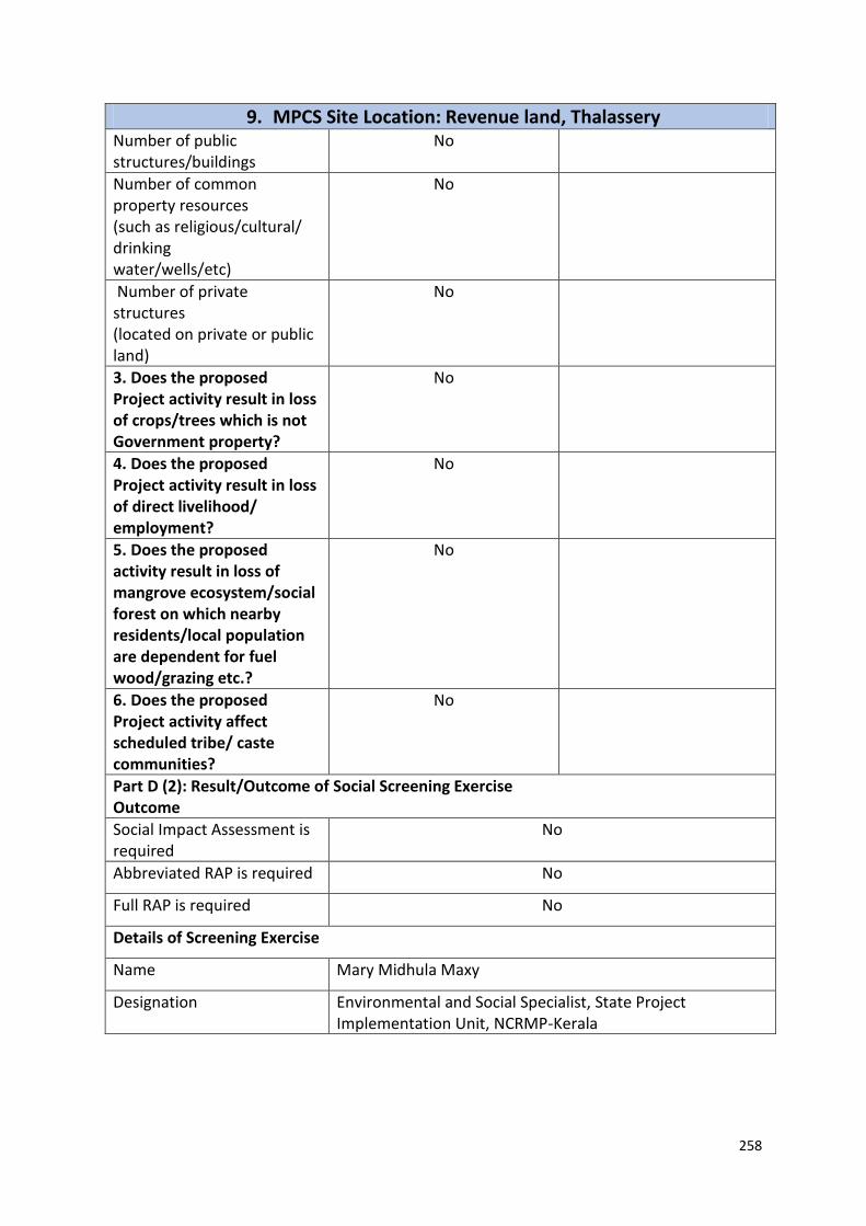
258
9. MPCS Site Location: Revenue land, Thalassery Number of public structures/buildings
No
Number of common property resources (such as religious/cultural/ drinking water/wells/etc)
No
Number of private structures (located on private or public land)
No
3. Does the proposed Project activity result in loss of crops/trees which is not Government property?
No
4. Does the proposed Project activity result in loss of direct livelihood/ employment?
No
5. Does the proposed activity result in loss of mangrove ecosystem/social forest on which nearby residents/local population are dependent for fuel wood/grazing etc.?
No
6. Does the proposed Project activity affect scheduled tribe/ caste communities?
No
Part D (2): Result/Outcome of Social Screening Exercise Outcome
Social Impact Assessment is required
No
Abbreviated RAP is required No
Full RAP is required No
Details of Screening Exercise
Name Mary Midhula Maxy
Designation Environmental and Social Specialist, State Project Implementation Unit, NCRMP-Kerala

259
10. MPCS Site Location: Revenue land, Azhikode South Part A: General Information about the sub-project Sub Project id NCRMP/KER/KNR/KAN/AZHIKODE SOUTH-1
Type of proposed sub-project activity MPCS
Location of the sub project activity
State Kerala
District Kannur
Taluk Kannur
Village Azhikode South
Panchayath/Municipal Corporation Azhikode Panchayath
Survey Number Survey number: 567/3
Latitude 11° 54’ 26.8” N
Longitude 75° 19’ 32.8”E
Mean Sea Level 17 m
Size of the sub-project
Cyclone Shelter – approx. built up area 900 SQ.M
Land requirement for the sub project (in Ha or m2)
Total Requirement
a. Private Land Nil
b. Government Land 500 SQ.M
c. Forest Land Nil
Existing Land use
Approach roads
Road name Meenkunnu Azhikode school road
Existing road -
Proposed road No approach road proposed
Boundary wall requirement No
Part B: Ascertaining whether the site is a prohibited site PART B1: List of sites where sub-projects are prohibited
Is the sub-project located in whole or within any of the following environmentally sensitive area?
Remarks if any
Biosphere reserve No
National Park No
Wildlife/Bird sanctuary No
Game reserve No
Tiger reserve/elephant reserve No
Wetland No
Important bird areas No
Coastal area with corals No
Mangrove area No
Estuary with mangroves No
Turtle nesting grounds No
Swamps/mudflats No
Notified sensitive eco zone No
Is the sub-project located in whole or in part between the HTL and the LTL?
No
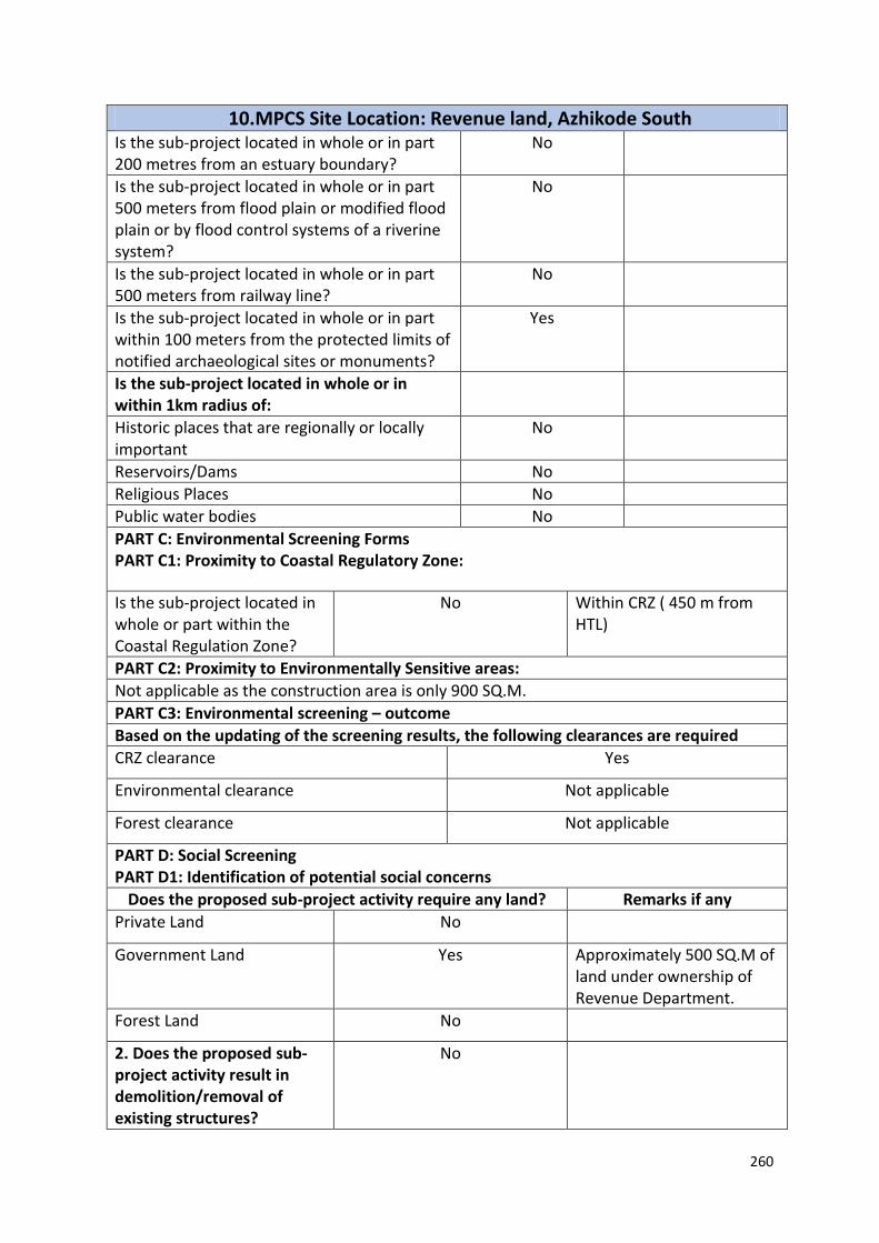
260
10. MPCS Site Location: Revenue land, Azhikode South Is the sub-project located in whole or in part 200 metres from an estuary boundary?
No
Is the sub-project located in whole or in part 500 meters from flood plain or modified flood plain or by flood control systems of a riverine system?
No
Is the sub-project located in whole or in part 500 meters from railway line?
No
Is the sub-project located in whole or in part within 100 meters from the protected limits of notified archaeological sites or monuments?
Yes
Is the sub-project located in whole or in within 1km radius of:
Historic places that are regionally or locally important
No
Reservoirs/Dams No
Religious Places No
Public water bodies No
PART C: Environmental Screening Forms PART C1: Proximity to Coastal Regulatory Zone:
Is the sub-project located in whole or part within the Coastal Regulation Zone?
No Within CRZ ( 450 m from HTL)
PART C2: Proximity to Environmentally Sensitive areas:
Not applicable as the construction area is only 900 SQ.M.
PART C3: Environmental screening – outcome
Based on the updating of the screening results, the following clearances are required
CRZ clearance Yes
Environmental clearance Not applicable
Forest clearance Not applicable
PART D: Social Screening PART D1: Identification of potential social concerns
Does the proposed sub-project activity require any land? Remarks if any
Private Land No
Government Land Yes Approximately 500 SQ.M of land under ownership of Revenue Department.
Forest Land No
2. Does the proposed sub-project activity result in demolition/removal of existing structures?
No

261
10. MPCS Site Location: Revenue land, Azhikode South Number of public structures/buildings
Yes One dilapidated building has to be demolished to facilitate construction of
MPCS
Number of common property resources (such as religious/cultural/ drinking water/wells/etc)
No
Number of private structures (located on private or public land)
No
3. Does the proposed Project activity result in loss of crops/trees which is not Government property?
No
4. Does the proposed Project activity result in loss of direct livelihood/ employment?
No
5. Does the proposed activity result in loss of mangrove ecosystem/social forest on which nearby residents/local population are dependent for fuel wood/grazing etc.?
No
6. Does the proposed Project activity affect scheduled tribe/ caste communities?
No
Part D (2): Result/Outcome of Social Screening Exercise Outcome
Social Impact Assessment is required
No
Abbreviated RAP is required No
Full RAP is required No
Details of Screening Exercise
Name Mary Midhula Maxy
Designation Environmental and Social Specialist, State Project Implementation Unit, NCRMP-Kerala
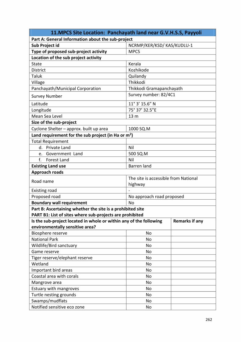
262
11. MPCS Site Location: Panchayath land near G.V.H.S.S, Payyoli Part A: General Information about the sub-project
Sub Project id NCRMP/KER/KSD/ KAS/KUDLU-1
Type of proposed sub-project activity MPCS
Location of the sub project activity
State Kerala
District Kozhikode
Taluk Quilandy
Village Thikkodi
Panchayath/Municipal Corporation Thikkodi Gramapanchayath
Survey Number Survey number: 82/4C1
Latitude 11° 3’ 15.6” N
Longitude 75° 37’ 32.5”E
Mean Sea Level 13 m
Size of the sub-project
Cyclone Shelter – approx. built up area 1000 SQ.M
Land requirement for the sub project (in Ha or m2)
Total Requirement
d. Private Land Nil
e. Government Land 500 SQ.M
f. Forest Land Nil
Existing Land use Barren land
Approach roads
Road name The site is accessible from National highway
Existing road -
Proposed road No approach road proposed
Boundary wall requirement No
Part B: Ascertaining whether the site is a prohibited site PART B1: List of sites where sub-projects are prohibited
Is the sub-project located in whole or within any of the following environmentally sensitive area?
Remarks if any
Biosphere reserve No
National Park No
Wildlife/Bird sanctuary No
Game reserve No
Tiger reserve/elephant reserve No
Wetland No
Important bird areas No
Coastal area with corals No
Mangrove area No
Estuary with mangroves No
Turtle nesting grounds No
Swamps/mudflats No
Notified sensitive eco zone No

263
11. MPCS Site Location: Panchayath land near G.V.H.S.S, Payyoli Is the sub-project located in whole or in part between the HTL and the LTL?
No
Is the sub-project located in whole or in part 200 metres from an estuary boundary?
No
Is the sub-project located in whole or in part 500 meters from flood plain or modified flood plain or by flood control systems of a riverine system?
No
Is the sub-project located in whole or in part 500 meters from railway line?
No
Is the sub-project located in whole or in part within 100 meters from the protected limits of notified archaeological sites or monuments?
No
Is the sub-project located in whole or in within 1km radius of:
Historic places that are regionally or locally important
No
Reservoirs/Dams No
Religious Places No
Public water bodies No
PART C: Environmental Screening Forms PART C1: Proximity to Coastal Regulatory Zone:
Is the sub-project located in whole or part within the Coastal Regulation Zone?
No Outside CRZ ( 1.5 km from HTL)
PART C2: Proximity to Environmentally Sensitive areas:
Not applicable as the construction area is ONLY 500 SQ.M.
PART C3: Environmental screening – outcome
Based on the updating of the screening results, the following clearances are required
CRZ clearance Not applicable
Environmental clearance Not applicable
Forest clearance Not applicable
PART D: Social Screening PART D1: Identification of potential social concerns
Does the proposed sub-project activity require any land?
Remarks if any
Private Land No
Government Land Yes Approximately 500 SQ.M of land under ownership of Education Department.
Forest Land No
2. Does the proposed sub-project activity result in
No

264
11. MPCS Site Location: Panchayath land near G.V.H.S.S, Payyoli demolition/removal of existing structures?
Number of public structures/buildings
No
Number of common property resources (such as religious/cultural/ drinking water/wells/etc)
No
Number of private structures (located on private or public land)
No
3. Does the proposed Project activity result in loss of crops/trees which is not Government property?
No
4. Does the proposed Project activity result in loss of direct livelihood/ employment?
No
5. Does the proposed activity result in loss of mangrove ecosystem/social forest on which nearby residents/local population are dependent for fuel wood/grazing etc.?
No
6. Does the proposed Project activity affect scheduled tribe/ caste communities?
No
Part D (2): Result/Outcome of Social Screening Exercise Outcome
Social Impact Assessment is required
No
Abbreviated RAP is required No
Full RAP is required No
Details of Screening Exercise
Name Mary Midhula Maxy
Designation Environmental and Social Specialist, State Project Implementation Unit, NCRMP-Kerala

265
12. MPCS Site Location: Corporation land in Nagaram Part A: General Information about the sub-project
Sub Project id NCRMP/KER/KZK/KZK/NAGARAM-1
Type of proposed sub-project activity MPCS
Location of the sub project activity
State Kerala
District Kozhikode
Taluk Kozhikode
Village Nagaram
Panchayath/Municipal Corporation Kozhikode Corporation
Survey Number Survey number: T.S 7-12-193
Latitude 11° 14’ 57.2” N
Longitude 75° 46’ 46.7”E
Mean Sea Level 39 m
Size of the sub-project
Cyclone Shelter – approx. built up area 1000 SQ.M
Land requirement for the sub project (in Ha or m2)
Total Requirement
a. Private Land Nil
b. Government Land 700 SQ.M
c. Forest Land Nil
Existing Land use Dilapidated building exist in the site
Approach roads
Road name Palayam road
Existing road -
Proposed road No approach road proposed
Boundary wall requirement No
Part B: Ascertaining whether the site is a prohibited site PART B1: List of sites where sub-projects are prohibited
Is the sub-project located in whole or within any of the following environmentally sensitive area?
Remarks if any
Biosphere reserve No
National Park No
Wildlife/Bird sanctuary No
Game reserve No
Tiger reserve/elephant reserve No
Wetland No
Important bird areas No
Coastal area with corals No
Mangrove area No
Estuary with mangroves No
Turtle nesting grounds No
Swamps/mudflats No
Notified sensitive eco zone No

266
12. MPCS Site Location: Corporation land in Nagaram Is the sub-project located in whole or in part between the HTL and the LTL?
No
Is the sub-project located in whole or in part 200 metres from an estuary boundary?
No
Is the sub-project located in whole or in part 500 meters from flood plain or modified flood plain or by flood control systems of a riverine system?
No
Is the sub-project located in whole or in part 500 meters from railway line?
No
Is the sub-project located in whole or in part within 100 meters from the protected limits of notified archaeological sites or monuments?
No
Is the sub-project located in whole or in within 1km radius of:
Historic places that are regionally or locally important
No
Reservoirs/Dams No
Religious Places Yes Site shares boundary wall with Mosque
Public water bodies Yes A well is located in the site
PART C: Environmental Screening Forms PART C1: Proximity to Coastal Regulatory Zone:
Is the sub-project located in whole or part within the Coastal Regulation Zone?
No Outside CRZ ( 800 m from HTL)
PART C2: Proximity to Environmentally Sensitive areas:
Not applicable as the construction area is only 1000 SQ.M.
PART C3: Environmental screening – outcome
Based on the updating of the screening results, the following clearances are required
CRZ clearance Not applicable
Environmental clearance Not applicable
Forest clearance Not applicable
PART D: Social Screening PART D1: Identification of potential social concerns
1.Does the proposed sub-project activity require any land? Remarks if any
Private Land No
Government Land Yes Approximately 700 SQ.M of land under ownership of Revenue Department.
Forest Land No

267
12. MPCS Site Location: Corporation land in Nagaram 2. Does the proposed sub-project activity result in demolition/removal of existing structures?
No
Number of public structures/buildings
No
Number of common property resources (such as religious/cultural/ drinking water/wells/etc)
No
Number of private structures (located on private or public land)
No
3. Does the proposed Project activity result in loss of crops/trees which is not Government property?
No
4. Does the proposed Project activity result in loss of direct livelihood/ employment?
No
5. Does the proposed activity result in loss of mangrove ecosystem/social forest on which nearby residents/local population are dependent for fuel wood/grazing etc.?
No
6. Does the proposed Project activity affect scheduled tribe/ caste communities?
No
Part D (2): Result/Outcome of Social Screening Exercise Outcome
Social Impact Assessment is required
No
Abbreviated RAP is required No
Full RAP is required No
Details of Screening Exercise
Name Mary Midhula Maxy
Designation Environmental and Social Specialist, State Project Implementation Unit, NCRMP-Kerala

268
13. MPCS Site Location: Revenue land in Nagaram Part A: General Information about the sub-project
Sub Project id NCRMP/KER/KZK/KZK/NAGARAM-2
Type of proposed sub-project activity MPCS
Location of the sub project activity
State Kerala
District Kozhikode
Taluk Kozhikode
Village Nagaram
Panchayath/Municipal Corporation Kozhikode Corporation
Survey Number Survey number: T.S 14-3-109
Latitude 11° 14’ 23.1” N
Longitude 75° 47’ 7.1”E
Mean Sea Level 39 m
Size of the sub-project
Cyclone Shelter – approx. built up area 1000 SQ.M
Land requirement for the sub project (in Ha or m2)
Total Requirement
a. Private Land Nil
b. Government Land 500 SQ.M
c. Forest Land Nil
Existing Land use Barren land
Approach roads
Road name Palyam Road
Existing road -
Proposed road No approach road proposed
Boundary wall requirement No
Part B: Ascertaining whether the site is a prohibited site PART B1: List of sites where sub-projects are prohibited
Is the sub-project located in whole or within any of the following environmentally sensitive area?
Remarks if any
Biosphere reserve No
National Park No
Wildlife/Bird sanctuary No
Game reserve No
Tiger reserve/elephant reserve No
Wetland No
Important bird areas No
Coastal area with corals No
Mangrove area No
Estuary with mangroves No
Turtle nesting grounds No
Swamps/mudflats No
Notified sensitive eco zone No

269
13. MPCS Site Location: Revenue land in Nagaram Is the sub-project located in whole or in part between the HTL and the LTL?
No
Is the sub-project located in whole or in part 200 metres from an estuary boundary?
No
Is the sub-project located in whole or in part 500 meters from flood plain or modified flood plain or by flood control systems of a riverine system?
No
Is the sub-project located in whole or in part 500 meters from railway line?
Yes A manned railway
crossing and railway
line is 80m to the
east of the site.
Is the sub-project located in whole or in part within 100 meters from the protected limits of notified archaeological sites or monuments?
No
Is the sub-project located in whole or in within 1km radius of:
Historic places that are regionally or locally important
No
Reservoirs/Dams No
Religious Places No
Public water bodies No
PART C: Environmental Screening Forms PART C1: Proximity to Coastal Regulatory Zone:
Is the sub-project located in whole or part within the Coastal Regulation Zone?
No Outside CRZ ( 1 km from HTL)
PART C2: Proximity to Environmentally Sensitive areas:
Not applicable as the construction area is only 1000 SQ.M.
PART C3: Environmental screening – outcome
Based on the updating of the screening results, the following clearances are required
CRZ clearance Not applicable
Environmental clearance Not applicable
Forest clearance Not applicable
PART D: Social Screening PART D1: Identification of potential social concerns
Does the proposed sub-project activity require any land? Remarks if any
Private Land No
Government Land Yes Approximately 500 SQ.M of land under ownership of Revenue Department.

270
13. MPCS Site Location: Revenue land in Nagaram Disparity in ownership details noted in records.
Forest Land No
2. Does the proposed sub-project activity result in demolition/removal of existing structures?
No
Number of public structures/buildings
No
Number of common property resources (such as religious/cultural/ drinking water/wells/etc)
No
Number of private structures (located on private or public land)
No
3. Does the proposed Project activity result in loss of crops/trees which is not Government property?
No Coconut plantation
4. Does the proposed Project activity result in loss of direct livelihood/ employment?
No
5. Does the proposed activity result in loss of mangrove ecosystem/social forest on which nearby residents/local population are dependent for fuel wood/grazing etc.?
No
6. Does the proposed Project activity affect scheduled tribe/ caste communities?
No
Part D (2): Result/Outcome of Social Screening Exercise Outcome
Social Impact Assessment is required
No
Abbreviated RAP is required No
Full RAP is required No
Details of Screening Exercise
Name Mary Midhula Maxy
Designation Environmental and Social Specialist, State Project Implementation Unit, NCRMP-Kerala

271
14. MPCS Site Location: Revenue land, Beypore Part A: General Information about the sub-project
Sub Project id NCRMP/KER/KZK/KZK/BEYPORE-1
Type of proposed sub-project activity MPCS
Location of the sub project activity
State Kerala
District Kozhikode
Taluk Kozhikode
Village Beypore
Panchayath/Municipal Corporation Beypore Gramapanchayath
Survey Number Survey number: T.S 156
Latitude 11° 11’ 35.8” N
Longitude 75° 47’ 31.3”E
Mean Sea Level 20 m
Size of the sub-project
Cyclone Shelter – approx. built up area 1500 SQ.M
Land requirement for the sub project (in Ha or m2)
Total Requirement
a. Private Land Nil
b. Government Land 900 SQ.M
c. Forest Land Nil
Existing Land use Barren land
Approach roads
Road name Beypore road
Existing road ROW: 12 m
Proposed road No approach road proposed
Boundary wall requirement No
Part B: Ascertaining whether the site is a prohibited site PART B1: List of sites where sub-projects are prohibited
Is the sub-project located in whole or within any of the following environmentally sensitive area?
Remarks if any
Biosphere reserve No
National Park No
Wildlife/Bird sanctuary No
Game reserve No
Tiger reserve/elephant reserve No
Wetland No
Important bird areas No
Coastal area with corals No
Mangrove area No
Estuary with mangroves No
Turtle nesting grounds No
Swamps/mudflats No
Notified sensitive eco zone No

272
14. MPCS Site Location: Revenue land, Beypore Is the sub-project located in whole or in part between the HTL and the LTL?
- The site is in close
proximity to the sea
(around 50m). The
site clearly falls in
the non-
development zone
of CRZ.
Is the sub-project located in whole or in part 200 metres from an estuary boundary?
No
Is the sub-project located in whole or in part 500 meters from flood plain or modified flood plain or by flood control systems of a riverine system?
No
Is the sub-project located in whole or in part 500 meters from railway line?
No
Is the sub-project located in whole or in part within 100 meters from the protected limits of notified archaeological sites or monuments?
No
Is the sub-project located in whole or in within 1km radius of:
Historic places that are regionally or locally important
No
Reservoirs/Dams No
Religious Places No
Public water bodies No
PART C: Environmental Screening Forms PART C1: Proximity to Coastal Regulatory Zone:
Is the sub-project located in whole or part within the Coastal Regulation Zone?
No The site is in close proximity
to the sea (around 50m). The
site clearly falls in the non-
development zone of CRZ
PART C2: Proximity to Environmentally Sensitive areas:
Not applicable as the construction area is only 1500 SQ.M.
PART C3: Environmental screening – outcome
Based on the updating of the screening results, the following clearances are required
CRZ clearance Not applicable
Environmental clearance Not applicable
Forest clearance Not applicable
PART D: Social Screening PART D1: Identification of potential social concerns
1.Does the proposed sub-project activity require any land? Remarks if any

273
14. MPCS Site Location: Revenue land, Beypore Private Land No
Government Land Yes Approximately 500 SQ.M of land under ownership of Revenue Department.
Forest Land No
2. Does the proposed sub-project activity result in demolition/removal of existing structures?
No
Number of public structures/buildings No
Number of common property resources (such as religious/cultural/ drinking water/wells/etc)
No
Number of private structures (located on private or public land)
No
3. Does the proposed Project activity result in loss of crops/trees which is not Government property?
No
4. Does the proposed Project activity result in loss of direct livelihood/ employment?
No
5. Does the proposed activity result in loss of mangrove ecosystem/social forest on which nearby residents/local population are dependent for fuel wood/grazing etc.?
No
6. Does the proposed Project activity affect scheduled tribe/ caste communities?
No
Part D (2): Result/Outcome of Social Screening Exercise Outcome
Social Impact Assessment is required No
Abbreviated RAP is required No
Full RAP is required No
Details of Screening Exercise
Name Mary Midhula Maxy
Designation Environmental and Social Specialist, State Project Implementation Unit, NCRMP-Kerala

274
15. MPCS Site Location: Government School, Padinjarekkara Part A: General Information about the sub-project
Sub Project id NCRMP/KER/MAL/TIR/ PURATHOOR-1
Type of proposed sub-project activity MPCS
Location of the sub project activity
State Kerala
District Malappuram
Taluk Tirur
Village Purathoor
Panchayath/Municipal Corporation Purathoor Gramapanchayath
Survey Number Block 37, Survey number: 232
Latitude 10° 48' 34.5"N
Longitude 75° 54' 32.8"E
Mean Sea Level 30 m
Size of the sub-project
Cyclone Shelter – approx. built up area 1500 SQ.M
Land requirement for the sub project (in Ha or m2)
Total Requirement
a. Private Land Nil
b. Government Land 800 SQ.M
c. Forest Land Nil
Existing Land use Barren land
Approach roads
Road name Tippu Sulthan Road
Existing road 12m ROW
Proposed road No approach road proposed
Boundary wall requirement No
Part B: Ascertaining whether the site is a prohibited site PART B1: List of sites where sub-projects are prohibited
Is the sub-project located in whole or within any of the following environmentally sensitive area?
Remarks if any
Biosphere reserve No
National Park No
Wildlife/Bird sanctuary No
Game reserve No
Tiger reserve/elephant reserve No
Wetland No
Important bird areas No
Coastal area with corals No
Mangrove area No
Estuary with mangroves No
Turtle nesting grounds No
Swamps/mudflats No
Notified sensitive eco zone No

275
15. MPCS Site Location: Government School, Padinjarekkara Is the sub-project located in whole or in part between the HTL and the LTL?
No
Is the sub-project located in whole or in part 200 metres from an estuary boundary?
No
Is the sub-project located in whole or in part 500 meters from flood plain or modified flood plain or by flood control systems of a riverine system?
No
Is the sub-project located in whole or in part 500 meters from railway line?
No Site is 3.6 km from railway line
Is the sub-project located in whole or in part within 100 meters from the protected limits of notified archaeological sites or monuments?
No
Is the sub-project located in whole or in within 1km radius of:
Historic places that are regionally or locally important
No
Reservoirs/Dams No
Religious Places No
Public water bodies No
PART C: Environmental Screening Forms PART C1: Proximity to Coastal Regulatory Zone:
Is the sub-project located in whole or part within the Coastal Regulation Zone?
No Outside CRZ ( 3 km from HTL)
PART C2: Proximity to Environmentally Sensitive areas:
Not applicable as the construction area is less than 1500 SQ.M.
PART C3: Environmental screening – outcome
Based on the updating of the screening results, the following clearances are required
CRZ clearance Not applicable
Environmental clearance Not applicable
Forest clearance Not applicable
PART D: Social Screening PART D1: Identification of potential social concerns
Does the proposed sub-project activity require any land?
Remarks if any
Private Land No
Government Land Yes Approximately 800 SQ.M of land under ownership of Education Department.
Forest Land No
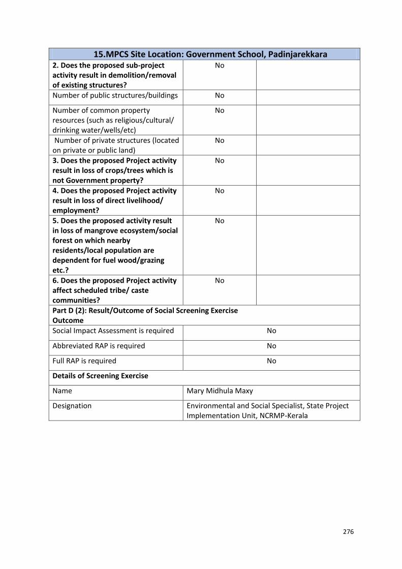
276
15. MPCS Site Location: Government School, Padinjarekkara 2. Does the proposed sub-project activity result in demolition/removal of existing structures?
No
Number of public structures/buildings No
Number of common property resources (such as religious/cultural/ drinking water/wells/etc)
No
Number of private structures (located on private or public land)
No
3. Does the proposed Project activity result in loss of crops/trees which is not Government property?
No
4. Does the proposed Project activity result in loss of direct livelihood/ employment?
No
5. Does the proposed activity result in loss of mangrove ecosystem/social forest on which nearby residents/local population are dependent for fuel wood/grazing etc.?
No
6. Does the proposed Project activity affect scheduled tribe/ caste communities?
No
Part D (2): Result/Outcome of Social Screening Exercise Outcome
Social Impact Assessment is required No
Abbreviated RAP is required No
Full RAP is required No
Details of Screening Exercise
Name Mary Midhula Maxy
Designation Environmental and Social Specialist, State Project Implementation Unit, NCRMP-Kerala

277
16. MPCS Site Location: Government Lower Primary School, Velliri Part A: General Information about the sub-project
Sub Project id NCRMP/KER/MAL/PON/PONANNI NAGARAM-1
Type of proposed sub-project activity MPCS
Location of the sub project activity
State Kerala
District Malappuram
Taluk Ponnani
Village Ponnani Nagaram
Panchayath/Municipal Corporation Ponnani Municipal Corporation
Survey Number Survey number: 107/1, 107/2 B2
Latitude 10° 47’ 2.0“N
Longitude 75° 55’ 55.7”E
Mean Sea Level 36 m
Size of the sub-project
Cyclone Shelter – approx. built up area 1200 SQ.M
Land requirement for the sub project (in Ha or m2)
Total Requirement
a. Private Land Nil
b. Government Land 600 SQ.M
c. Forest Land Nil
Existing Land use Dilapidated buildings exists in the site
Approach roads
Road name Veleeri school road
Existing road Length 750 m ROW: 3 m
Proposed road No approach road proposed
Boundary wall requirement No
Part B: Ascertaining whether the site is a prohibited site PART B1: List of sites where sub-projects are prohibited
Is the sub-project located in whole or within any of the following environmentally sensitive area?
Remarks if any
Biosphere reserve No
National Park No
Wildlife/Bird sanctuary No
Game reserve No
Tiger reserve/elephant reserve No
Wetland No The site is 2-3km
from Backwaters
Important bird areas No
Coastal area with corals No
Mangrove area No
Estuary with mangroves No
Turtle nesting grounds No

278
16. MPCS Site Location: Government Lower Primary School, Velliri Swamps/mudflats No
Notified sensitive eco zone No
Is the sub-project located in whole or in part between the HTL and the LTL?
No
Is the sub-project located in whole or in part 200 metres from an estuary boundary?
No
Is the sub-project located in whole or in part 500 meters from flood plain or modified flood plain or by flood control systems of a riverine system?
No
Is the sub-project located in whole or in part 500 meters from railway line?
No
Is the sub-project located in whole or in part within 100 meters from the protected limits of notified archaeological sites or monuments?
No
Is the sub-project located in whole or in within 1km radius of:
Historic places that are regionally or locally important
No
Reservoirs/Dams No
Religious Places No
Public water bodies No
PART C: Environmental Screening Forms PART C1: Proximity to Coastal Regulatory Zone:
Is the sub-project located in whole or part within the Coastal Regulation Zone?
No Outside CRZ ( 1.5 km from HTL)
PART C2: Proximity to Environmentally Sensitive areas:
Not applicable as the construction area is less than 1300 SQ.M.
PART C3: Environmental screening – outcome
Based on the updating of the screening results, the following clearances are required
CRZ clearance Not applicable
Environmental clearance Not applicable
Forest clearance Not applicable
PART D: Social Screening PART D1: Identification of potential social concerns
Does the proposed sub-project activity require any land?
Remarks if any
Private Land No

279
16. MPCS Site Location: Government Lower Primary School, Velliri Government Land Yes Approximately 600 SQ.M of
land under ownership of Education Department.
Forest Land No
2. Does the proposed sub-project activity result in demolition/removal of existing structures?
Yes Two dilapidated buildings exits in the site which has to be demolished to facilitate
construction
Number of public structures/buildings No
Number of common property resources (such as religious/cultural/ drinking water/wells/etc)
No
Number of private structures (located on private or public land)
No
3. Does the proposed Project activity result in loss of crops/trees which is not Government property?
No
4. Does the proposed Project activity result in loss of direct livelihood/ employment?
No
5. Does the proposed activity result in loss of mangrove ecosystem/social forest on which nearby residents/local population are dependent for fuel wood/grazing etc.?
No
6. Does the proposed Project activity affect scheduled tribe/ caste communities?
No
Part D (2): Result/Outcome of Social Screening Exercise Outcome
Social Impact Assessment is required No
Abbreviated RAP is required No
Full RAP is required No
Details of Screening Exercise
Name Mary Midhula Maxy
Designation Environmental and Social Specialist, State Project Implementation Unit, NCRMP-Kerala

280
17. MPCS Site Location: Government Fisheries Lower Primary School, Veliyankode
Part A: General Information about the sub-project
Sub Project id NCRMP/KER/MAL/PON/VELIYANKODE-1
Type of proposed sub-project activity MPCS
Location of the sub project activity
State Kerala
District Malappuram
Taluk Ponnani
Village Veliyankode
Panchayath/Municipal Corporation Ponnani Municipal Corporation
Survey Number Survey number: 249/3
Latitude 10° 43' 11.5"N
Longitude 75° 56' 36.6"E
Mean Sea Level 20 m
Size of the sub-project
Cyclone Shelter – approx. built up area 1500 SQ.M
Land requirement for the sub project (in Ha or m2)
Total Requirement
a. Private Land Nil
b. Government Land 800 SQ.M
c. Forest Land Nil
Existing Land use Two dilapidated buildings exists in the site
Approach roads
Road name Padathakayi road
Existing road Length 3km Width 12 m
Proposed road No approach road proposed
Boundary wall requirement No
Part B: Ascertaining whether the site is a prohibited site PART B1: List of sites where sub-projects are prohibited
Is the sub-project located in whole or within any of the following environmentally sensitive area?
Remarks if any
Biosphere reserve No
National Park No
Wildlife/Bird sanctuary No
Game reserve No
Tiger reserve/elephant reserve No
Wetland No
Important bird areas No
Coastal area with corals No
Mangrove area No
Estuary with mangroves No
Turtle nesting grounds No
Swamps/mudflats No

281
17. MPCS Site Location: Government Fisheries Lower Primary School, Veliyankode
Notified sensitive eco zone No
Is the sub-project located in whole or in part between the HTL and the LTL?
No
Is the sub-project located in whole or in part 200 metres from an estuary boundary?
No
Is the sub-project located in whole or in part 500 meters from flood plain or modified flood plain or by flood control systems of a riverine system?
No
.
Is the sub-project located in whole or in part 500 meters from railway line?
No
Is the sub-project located in whole or in part within 100 meters from the protected limits of notified archaeological sites or monuments?
No
Is the sub-project located in whole or in within 1km radius of:
Historic places that are regionally or locally important
No
Reservoirs/Dams No
Religious Places Yes A mosque is located near to the site
Public water bodies No
PART C: Environmental Screening Forms PART C1: Proximity to Coastal Regulatory Zone:
Is the sub-project located in whole or part within the Coastal Regulation Zone?
Yes Outside CRZ ( 0.1 km from HTL)
PART C2: Proximity to Environmentally Sensitive areas:
Not applicable as the construction area is less than 1500 SQ.M.
PART C3: Environmental screening – outcome
Based on the updating of the screening results, the following clearances are required
CRZ clearance Not applicable
Environmental clearance Not applicable
Forest clearance Not applicable
PART D: Social Screening PART D1: Identification of potential social concerns
Does the proposed sub-project activity require any land? Remarks if any
Private Land No
Government Land Yes Approximately 800 SQ.M of land under ownership of Education Department.
Forest Land No

282
17. MPCS Site Location: Government Fisheries Lower Primary School, Veliyankode
2. Does the proposed sub-project activity result in demolition/removal of existing structures?
Yes Two dilapidated buildings exists in the site
Number of public structures/buildings
No
Number of common property resources (such as religious/cultural/ drinking water/wells/etc)
No
Number of private structures (located on private or public land)
No
3. Does the proposed Project activity result in loss of crops/trees which is not Government property?
No
4. Does the proposed Project activity result in loss of direct livelihood/ employment?
No
5. Does the proposed activity result in loss of mangrove ecosystem/social forest on which nearby residents/local population are dependent for fuel wood/grazing etc.?
No
6. Does the proposed Project activity affect scheduled tribe/ caste communities?
No
Part D (2): Result/Outcome of Social Screening Exercise Outcome
Social Impact Assessment is required No
Abbreviated RAP is required No
Full RAP is required No
Details of Screening Exercise
Name Mary Midhula Maxy
Designation Environmental and Social Specialist, State Project Implementation Unit, NCRMP-Kerala

283
18. MPCS Site Location: Revenue land near Village Office, Niramaruthur Part A: General Information about the sub-project
Sub Project id NCRMP/KER/MAL/TIR/NIRAMARUTHUR-1
Type of proposed sub-project activity MPCS
Location of the sub project activity
State Kerala
District Malappuram
Taluk Tirur
Village Niramaruthur
Panchayath/Municipal Corporation -
Survey Number Survey number: 246/8
Latitude 10° 55' 37.3" N
Longitude 75° 53' 29.9"E
Mean Sea Level 34 m
Size of the sub-project
Cyclone Shelter – approx. built up area No area available for construction
Land requirement for the sub project (in Ha or m2)
Total Requirement
a. Private Land Nil
b. Government Land Less than 300 SQ.M
c. Forest Land Nil
Existing Land use Village Office Functions in the site
Approach roads
Road name Kaladi Unniyal Road
Existing road ROW: 6 m
Proposed road No approach road proposed
Boundary wall requirement No
Part B: Ascertaining whether the site is a prohibited site PART B1: List of sites where sub-projects are prohibited
Is the sub-project located in whole or within any of the following environmentally sensitive area?
Remarks if any
Biosphere reserve No
National Park No
Wildlife/Bird sanctuary No
Game reserve No
Tiger reserve/elephant reserve No
Wetland No
Important bird areas No
Coastal area with corals No
Mangrove area No
Estuary with mangroves No
Turtle nesting grounds No
Swamps/mudflats No
Notified sensitive eco zone No
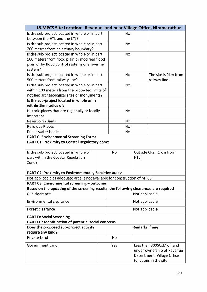
284
18. MPCS Site Location: Revenue land near Village Office, Niramaruthur Is the sub-project located in whole or in part between the HTL and the LTL?
No
Is the sub-project located in whole or in part 200 metres from an estuary boundary?
No
Is the sub-project located in whole or in part 500 meters from flood plain or modified flood plain or by flood control systems of a riverine system?
No
Is the sub-project located in whole or in part 500 meters from railway line?
No The site is 2km from railway line
Is the sub-project located in whole or in part within 100 meters from the protected limits of notified archaeological sites or monuments?
No
Is the sub-project located in whole or in within 1km radius of:
Historic places that are regionally or locally important
No
Reservoirs/Dams No
Religious Places No
Public water bodies No
PART C: Environmental Screening Forms PART C1: Proximity to Coastal Regulatory Zone:
Is the sub-project located in whole or part within the Coastal Regulation Zone?
No Outside CRZ ( 1 km from HTL)
PART C2: Proximity to Environmentally Sensitive areas:
Not applicable as adequate area is not available for construction of MPCS
PART C3: Environmental screening – outcome
Based on the updating of the screening results, the following clearances are required
CRZ clearance Not applicable
Environmental clearance Not applicable
Forest clearance Not applicable
PART D: Social Screening PART D1: Identification of potential social concerns
Does the proposed sub-project activity require any land?
Remarks if any
Private Land No
Government Land Yes Less than 300SQ.M of land under ownership of Revenue Department. Village Office functions in the site

285
18. MPCS Site Location: Revenue land near Village Office, Niramaruthur Forest Land No
2. Does the proposed sub-project activity result in demolition/removal of existing structures?
-
Number of public structures/buildings No
Number of common property resources (such as religious/cultural/ drinking water/wells/etc)
No
Number of private structures (located on private or public land)
No
3. Does the proposed Project activity result in loss of crops/trees which is not Government property?
No
4. Does the proposed Project activity result in loss of direct livelihood/ employment?
No
5. Does the proposed activity result in loss of mangrove ecosystem/social forest on which nearby residents/local population are dependent for fuel wood/grazing etc.?
No
6. Does the proposed Project activity affect scheduled tribe/ caste communities?
No
Part D (2): Result/Outcome of Social Screening Exercise Outcome
Social Impact Assessment is required No
Abbreviated RAP is required No
Full RAP is required No
Details of Screening Exercise
Name Mary Midhula Maxy
Designation Environmental and Social Specialist, State Project Implementation Unit, NCRMP-Kerala
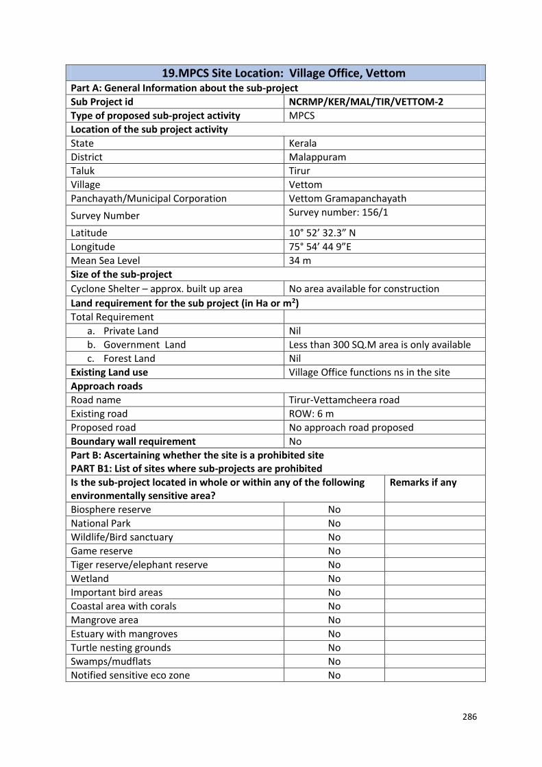
286
19. MPCS Site Location: Village Office, Vettom Part A: General Information about the sub-project
Sub Project id NCRMP/KER/MAL/TIR/VETTOM-2
Type of proposed sub-project activity MPCS
Location of the sub project activity
State Kerala
District Malappuram
Taluk Tirur
Village Vettom
Panchayath/Municipal Corporation Vettom Gramapanchayath
Survey Number Survey number: 156/1
Latitude 10° 52’ 32.3” N
Longitude 75° 54’ 44 9”E
Mean Sea Level 34 m
Size of the sub-project
Cyclone Shelter – approx. built up area No area available for construction
Land requirement for the sub project (in Ha or m2)
Total Requirement
a. Private Land Nil
b. Government Land Less than 300 SQ.M area is only available
c. Forest Land Nil
Existing Land use Village Office functions ns in the site
Approach roads
Road name Tirur-Vettamcheera road
Existing road ROW: 6 m
Proposed road No approach road proposed
Boundary wall requirement No
Part B: Ascertaining whether the site is a prohibited site PART B1: List of sites where sub-projects are prohibited
Is the sub-project located in whole or within any of the following environmentally sensitive area?
Remarks if any
Biosphere reserve No
National Park No
Wildlife/Bird sanctuary No
Game reserve No
Tiger reserve/elephant reserve No
Wetland No
Important bird areas No
Coastal area with corals No
Mangrove area No
Estuary with mangroves No
Turtle nesting grounds No
Swamps/mudflats No
Notified sensitive eco zone No

287
19. MPCS Site Location: Village Office, Vettom Is the sub-project located in whole or in part between the HTL and the LTL?
No
Is the sub-project located in whole or in part 200 metres from an estuary boundary?
No
Is the sub-project located in whole or in part 500 meters from flood plain or modified flood plain or by flood control systems of a riverine system?
No
Is the sub-project located in whole or in part 500 meters from railway line?
No Site is 2 km from the site
Is the sub-project located in whole or in part within 100 meters from the protected limits of notified archaeological sites or monuments?
No
Is the sub-project located in whole or in within 1km radius of:
Historic places that are regionally or locally important
No
Reservoirs/Dams No
Religious Places No
Public water bodies No
PART C: Environmental Screening Forms PART C1: Proximity to Coastal Regulatory Zone:
Is the sub-project located in whole or part within the Coastal Regulation Zone?
No Outside CRZ ( 2.3 km from HTL)
PART C2: Proximity to Environmentally Sensitive areas:
Not applicable as adequate area is not available for construction.
PART C3: Environmental screening – outcome
Based on the updating of the screening results, the following clearances are required
CRZ clearance Not applicable
Environmental clearance Not applicable
Forest clearance Not applicable
PART D: Social Screening PART D1: Identification of potential social concerns
1.Does the proposed sub-project activity require any land? Remarks if any
Private Land No
Government Land Yes Less than 300 SQ.M of land under ownership of Revenue Department.
Forest Land No
2. Does the proposed sub-project activity result in
No

288
19. MPCS Site Location: Village Office, Vettom demolition/removal of existing structures?
Number of public structures/buildings
No
Number of common property resources (such as religious/cultural/ drinking water/wells/etc)
No
Number of private structures (located on private or public land)
No
3. Does the proposed Project activity result in loss of crops/trees which is not Government property?
No
4. Does the proposed Project activity result in loss of direct livelihood/ employment?
No
5. Does the proposed activity result in loss of mangrove ecosystem/social forest on which nearby residents/local population are dependent for fuel wood/grazing etc.?
No
6. Does the proposed Project activity affect scheduled tribe/ caste communities?
No
Part D (2): Result/Outcome of Social Screening Exercise Outcome
Social Impact Assessment is required No
Abbreviated RAP is required No
Full RAP is required No
Details of Screening Exercise
Name Mary Midhula Maxy
Designation Environmental and Social Specialist, State Project Implementation Unit, NCRMP-Kerala

289
20. MPCS Site Location: Revenue land, Kootayi Part A: General Information about the sub-project
Sub Project id NCRMP/KER/MAL/TIR/MANGALAM-1
Type of proposed sub-project activity MPCS
Location of the sub project activity
State Kerala
District Malappuram
Taluk Tirur
Village Mangalam
Panchayath/Municipal Corporation Mangalam Gramapanchayath
Survey Number Survey number: 16/6B
Latitude 10° 51' 5.22" N
Longitude 75° 53' 52.02"E
Mean Sea Level 35 m
Size of the sub-project
Cyclone Shelter – approx. built up area 1000 SQ.M
Land requirement for the sub project (in Ha or m2)
Total Requirement
a. Private Land Nil
b. Government Land 600 SQ.M
c. Forest Land Nil
Existing Land use Barren land
Approach roads
Road name Tippu Sulthan Road
Existing road ROW: 12 m
Proposed road No approach road proposed
Boundary wall requirement No
Part B: Ascertaining whether the site is a prohibited site PART B1: List of sites where sub-projects are prohibited
Is the sub-project located in whole or within any of the following environmentally sensitive area?
Remarks if any
Biosphere reserve No
National Park No
Wildlife/Bird sanctuary No
Game reserve No
Tiger reserve/elephant reserve No
Wetland No
Important bird areas No
Coastal area with corals No
Mangrove area No
Estuary with mangroves No
Turtle nesting grounds No
Swamps/mudflats No
Notified sensitive eco zone No

290
20. MPCS Site Location: Revenue land, Kootayi Is the sub-project located in whole or in part between the HTL and the LTL?
No
Is the sub-project located in whole or in part 200 metres from an estuary boundary?
No
Is the sub-project located in whole or in part 500 meters from flood plain or modified flood plain or by flood control systems of a riverine system?
No
Is the sub-project located in whole or in part 500 meters from railway line?
No
Is the sub-project located in whole or in part within 100 meters from the protected limits of notified archaeological sites or monuments?
No
Is the sub-project located in whole or in within 1km radius of:
Historic places that are regionally or locally important
No
Reservoirs/Dams No
Religious Places No
Public water bodies No
PART C: Environmental Screening Forms PART C1: Proximity to Coastal Regulatory Zone:
Is the sub-project located in whole or part within the Coastal Regulation Zone?
Yes Within CRZ ( 0.9 m from HTL)
PART C2: Proximity to Environmentally Sensitive areas:
Not applicable as the construction area is less than 600 SQ.M.
PART C3: Environmental screening – outcome
Based on the updating of the screening results, the following clearances are required
CRZ clearance Not applicable
Environmental clearance Not applicable
Forest clearance Not applicable
PART D: Social Screening PART D1: Identification of potential social concerns
1.Does the proposed sub-project activity require any land? Remarks if any
Private Land No
Government Land Yes Approximately 500 SQ.M of land under ownership of Revenue Department.
Forest Land No
2. Does the proposed sub-project activity result in
No

291
20. MPCS Site Location: Revenue land, Kootayi demolition/removal of existing structures?
Number of public structures/buildings
No
Number of common property resources (such as religious/cultural/ drinking water/wells/etc)
No
Number of private structures (located on private or public land)
No
3. Does the proposed Project activity result in loss of crops/trees which is not Government property?
Yes Coconut plantation
4. Does the proposed Project activity result in loss of direct livelihood/ employment?
No
5. Does the proposed activity result in loss of mangrove ecosystem/social forest on which nearby residents/local population are dependent for fuel wood/grazing etc.?
No
6. Does the proposed Project activity affect scheduled tribe/ caste communities?
No
Part D (2): Result/Outcome of Social Screening Exercise Outcome
Social Impact Assessment is required
No
Abbreviated RAP is required No
Full RAP is required No
Details of Screening Exercise
Name Mary Midhula Maxy
Designation Environmental and Social Specialist, State Project Implementation Unit, NCRMP-Kerala

292
21. MPCS Site Location: Tsunami Shelter, Ponnani Part A: General Information about the sub-project
Sub Project id NCRMP/KER/MAL/PON/PONNANI NAGARAM-2
Type of proposed sub-project activity MPCS
Location of the sub project activity
State Kerala
District Malappuram
Taluk Ponnani
Village Ponnani Nagaram
Panchayath/Municipal Corporation Ponnani Municipal Corporation
Survey Number Survey number: 1/145
Latitude 12⁰ 32' 25.9”N
Longitude 74⁰ 59' 38.3"E
Mean Sea Level 50 m
Size of the sub-project
Cyclone Shelter – approx. built up area No area available for construction
Land requirement for the sub project (in Ha or m2)
Total Requirement
a. Private Land Nil
b. Government Land 1300 SQ.M
c. Forest Land Nil
Existing Land use Tsunami Disaster Shelter functions in the site
Approach roads
Road name Hillarpalli road
Existing road Length 600m ROW 8 m
Proposed road No approach road proposed
Boundary wall requirement No
Part B: Ascertaining whether the site is a prohibited site PART B1: List of sites where sub-projects are prohibited
Is the sub-project located in whole or within any of the following environmentally sensitive area?
Remarks if any
Biosphere reserve No
National Park No
Wildlife/Bird sanctuary No
Game reserve No
Tiger reserve/elephant reserve No
Wetland No
Important bird areas No
Coastal area with corals No
Mangrove area No
Estuary with mangroves No
Turtle nesting grounds No
Swamps/mudflats No

293
21. MPCS Site Location: Tsunami Shelter, Ponnani Notified sensitive eco zone No
Is the sub-project located in whole or in part between the HTL and the LTL?
No
Is the sub-project located in whole or in part 200 metres from an estuary boundary?
No
Is the sub-project located in whole or in part 500 meters from flood plain or modified flood plain or by flood control systems of a riverine system?
No
Is the sub-project located in whole or in part 500 meters from railway line?
No
Is the sub-project located in whole or in part within 100 meters from the protected limits of notified archaeological sites or monuments?
No
Is the sub-project located in whole or in within 1km radius of:
Historic places that are regionally or locally important
No
Reservoirs/Dams No
Religious Places No
Public water bodies No
PART C: Environmental Screening Forms PART C1: Proximity to Coastal Regulatory Zone:
Is the sub-project located in whole or part within the Coastal Regulation Zone?
Yes Within CRZ ( 0.15 m from HTL)
PART C2: Proximity to Environmentally Sensitive areas:
Not applicable as adequate area is not available for construction
PART C3: Environmental screening – outcome
Based on the updating of the screening results, the following clearances are required
CRZ clearance Not applicable
Environmental clearance Not applicable
Forest clearance Not applicable
PART D: Social Screening PART D1: Identification of potential social concerns
Does the proposed sub-project activity require any land?
Remarks if any
Private Land No
Government Land Yes Tsunami disaster shelter functions in the site.
Forest Land No
2. Does the proposed sub-project activity result in demolition/removal of existing structures?
No

294
21. MPCS Site Location: Tsunami Shelter, Ponnani Number of public structures/buildings No
Number of common property resources (such as religious/cultural/ drinking water/wells/etc)
No
Number of private structures (located on private or public land)
No
3. Does the proposed Project activity result in loss of crops/trees which is not Government property?
Yes
4. Does the proposed Project activity result in loss of direct livelihood/ employment?
No
5. Does the proposed activity result in loss of mangrove ecosystem/social forest on which nearby residents/local population are dependent for fuel wood/grazing etc.?
No
6. Does the proposed Project activity affect scheduled tribe/ caste communities?
No
Part D (2): Result/Outcome of Social Screening Exercise Outcome
Social Impact Assessment is required No
Abbreviated RAP is required No
Full RAP is required No
Details of Screening Exercise
Name Mary Midhula Maxy
Designation Environmental and Social Specialist, State Project Implementation Unit, NCRMP-Kerala

295
22. MPCS Site Location: Kadappuram, Thrissur Part A: General Information about the sub-project
Sub Project id NCRMP/KER/TSR/ CHVD/KADAPPURAM-2
Type of proposed sub-project activity MPCS
Location of the sub project activity
State Kerala
District Thrissur
Taluk Thrissur
Village Kadappuram
Panchayath/Municipal Corporation Kadappuram Gramapanchayath
Survey Number Survey number: 116
Latitude 10⁰ 32' 11.5”N
Longitude 76⁰ 1' 39.1"E
Mean Sea Level 20 m
Size of the sub-project
Cyclone Shelter – approx. built up area 1800 SQ.M
Land requirement for the sub project (in Ha or m2)
Total Requirement
a. Private Land Nil
b. Government Land 1000 SQ.M
c. Forest Land Nil
Existing Land use Dilapidated shelters
Approach roads
Road name Monnamkallu-Anjangadi road
Existing road ROW: 9 m
Proposed road No approach road proposed
Boundary wall requirement No
Part B: Ascertaining whether the site is a prohibited site PART B1: List of sites where sub-projects are prohibited
Is the sub-project located in whole or within any of the following environmentally sensitive area?
Remarks if any
Biosphere reserve No
National Park No
Wildlife/Bird sanctuary No
Game reserve No
Tiger reserve/elephant reserve No
Wetland No
Important bird areas No
Coastal area with corals No
Mangrove area No
Estuary with mangroves No
Turtle nesting grounds No
Swamps/mudflats No
Notified sensitive eco zone No

296
22. MPCS Site Location: Kadappuram, Thrissur Is the sub-project located in whole or in part between the HTL and the LTL?
No
Is the sub-project located in whole or in part 200 metres from an estuary boundary?
No
Is the sub-project located in whole or in part 500 meters from flood plain or modified flood plain or by flood control systems of a riverine system?
No
Is the sub-project located in whole or in part 500 meters from railway line?
No
Is the sub-project located in whole or in part within 100 meters from the protected limits of notified archaeological sites or monuments?
No
Is the sub-project located in whole or in within 1km radius of:
Historic places that are regionally or locally important
No
Reservoirs/Dams No
Religious Places No
Public water bodies No
PART C: Environmental Screening Forms PART C1: Proximity to Coastal Regulatory Zone:
Is the sub-project located in whole or part within the Coastal Regulation Zone?
Yes Site is at a distance of 350m from HTL
PART C2: Proximity to Environmentally Sensitive areas:
Not applicable as the construction area is less than 1000 SQ.M.
PART C3: Environmental screening – outcome
Based on the updating of the screening results, the following clearances are required
CRZ clearance Yes
Environmental clearance Not applicable
Forest clearance Not applicable
PART D: Social Screening PART D1: Identification of potential social concerns
Does the proposed sub-project activity require any land? Remarks if any
Private Land No
Government Land Yes Approximately 1000 SQ.M of land under ownership of Revenue Department.

297
22. MPCS Site Location: Kadappuram, Thrissur Forest Land No
2. Does the proposed sub-project activity result in demolition/removal of existing structures?
No
Number of public structures/buildings 2 (Two) Two dilapidated shelters exists in the site which has to be
demolished to facilitate
construction.
Number of common property resources (such as religious/cultural/ drinking water/wells/etc)
No
Number of private structures (located on private or public land)
No
3. Does the proposed Project activity result in loss of crops/trees which is not Government property?
No
4. Does the proposed Project activity result in loss of direct livelihood/ employment?
No
5. Does the proposed activity result in loss of mangrove ecosystem/social forest on which nearby residents/local population are dependent for fuel wood/grazing etc.?
No
6. Does the proposed Project activity affect scheduled tribe/ caste communities?
No
Part D (2): Result/Outcome of Social Screening Exercise Outcome
Social Impact Assessment is required No
Abbreviated RAP is required No
Full RAP is required No
Details of Screening Exercise
Name Mary Midhula Maxy
Designation Environmental and Social Specialist, State Project Implementation Unit, NCRMP-Kerala

298
23. MPCS Site Location: Eriyad, Kodungalloor Part A: General Information about the sub-project
Sub Project id NCRMP/KER/TSR/KOD/ERIYAD-1
Type of proposed sub-project activity MPCS
Location of the sub project activity
State Kerala
District Thrissur
Taluk Kodungalloor
Village Eriyad
Panchayath/Municipal Corporation Eriyad Gramapanchayath
Survey Number Survey number: 670/1
Latitude 10°11'19.90"N
Longitude 76° 9'38.40"E
Mean Sea Level 20 m
Size of the sub-project
Cyclone Shelter – approx. built up area No area available for construction
Land requirement for the sub project (in Ha or m2)
Total Requirement
a. Private Land Nil
b. Government Land No area available for construction
c. Forest Land Nil
Existing Land use Shelter functions in the site
Approach roads
Road name Puthenpalli-Munakkal beach road
Existing road ROW: 4 m
Proposed road No approach road proposed
Boundary wall requirement No
Part B: Ascertaining whether the site is a prohibited site PART B1: List of sites where sub-projects are prohibited
Is the sub-project located in whole or within any of the following environmentally sensitive area?
Remarks if any
Biosphere reserve No
National Park No
Wildlife/Bird sanctuary No
Game reserve No
Tiger reserve/elephant reserve No
Wetland No
Important bird areas No
Coastal area with corals No
Mangrove area No
Estuary with mangroves No
Turtle nesting grounds No
Swamps/mudflats No
Notified sensitive eco zone No

299
23. MPCS Site Location: Eriyad, Kodungalloor Is the sub-project located in whole or in part between the HTL and the LTL?
No
Is the sub-project located in whole or in part 200 metres from an estuary boundary?
No
Is the sub-project located in whole or in part 500 meters from flood plain or modified flood plain or by flood control systems of a riverine system?
No
Is the sub-project located in whole or in part 500 meters from railway line?
No
Is the sub-project located in whole or in part within 100 meters from the protected limits of notified archaeological sites or monuments?
No
Is the sub-project located in whole or in within 1km radius of:
Historic places that are regionally or locally important
No
Reservoirs/Dams No
Religious Places No
Public water bodies No
PART C: Environmental Screening Forms PART C1: Proximity to Coastal Regulatory Zone:
Is the sub-project located in whole or part within the Coastal Regulation Zone?
Yes Site is at a distance of 0.80 km from HTL
PART C2: Proximity to Environmentally Sensitive areas:
No area available for construction since one shelter is already functioning in the site
PART C3: Environmental screening – outcome
Based on the updating of the screening results, the following clearances are required
CRZ clearance Yes
Environmental clearance Not applicable
Forest clearance Not applicable
PART D: Social Screening PART D1: Identification of potential social concerns
Does the proposed sub-project activity require any land? Remarks if any
Private Land No
Government Land Yes No area avaible for construction as a shelter is already function in the site
Forest Land No
2. Does the proposed sub-project activity result in
- A shelter is already function in the site

300
23. MPCS Site Location: Eriyad, Kodungalloor demolition/removal of existing structures?
Number of public structures/buildings
No
Number of common property resources (such as religious/cultural/ drinking water/wells/etc)
No
Number of private structures (located on private or public land)
No
3. Does the proposed Project activity result in loss of crops/trees which is not Government property?
No
4. Does the proposed Project activity result in loss of direct livelihood/ employment?
No
5. Does the proposed activity result in loss of mangrove ecosystem/social forest on which nearby residents/local population are dependent for fuel wood/grazing etc.?
No
6. Does the proposed Project activity affect scheduled tribe/ caste communities?
No
Part D (2): Result/Outcome of Social Screening Exercise Outcome
Social Impact Assessment is required
No
Abbreviated RAP is required No
Full RAP is required No
Details of Screening Exercise
Name Mary Midhula Maxy
Designation Environmental and Social Specialist, State Project Implementation Unit, NCRMP-Kerala
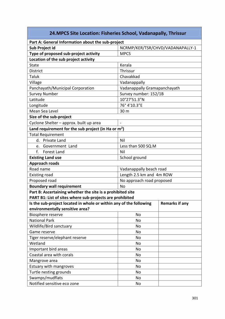
301
24. MPCS Site Location: Fisheries School, Vadanapally, Thrissur
Part A: General Information about the sub-project
Sub Project id NCRMP/KER/TSR/CHVD/VADANAPALLY-1
Type of proposed sub-project activity MPCS
Location of the sub project activity
State Kerala
District Thrissur
Taluk Chavakkad
Village Vadanappally
Panchayath/Municipal Corporation Vadanappally Gramapanchayath
Survey Number Survey number: 152/1B
Latitude 10°27'51.3"N
Longitude 76° 4'10.3"E
Mean Sea Level 30 m
Size of the sub-project
Cyclone Shelter – approx. built up area -
Land requirement for the sub project (in Ha or m2)
Total Requirement
d. Private Land Nil
e. Government Land Less than 500 SQ.M
f. Forest Land Nil
Existing Land use School ground
Approach roads
Road name Vadanappally beach road
Existing road Length 2.5 km and 4m ROW
Proposed road No approach road proposed
Boundary wall requirement No
Part B: Ascertaining whether the site is a prohibited site PART B1: List of sites where sub-projects are prohibited
Is the sub-project located in whole or within any of the following environmentally sensitive area?
Remarks if any
Biosphere reserve No
National Park No
Wildlife/Bird sanctuary No
Game reserve No
Tiger reserve/elephant reserve No
Wetland No
Important bird areas No
Coastal area with corals No
Mangrove area No
Estuary with mangroves No
Turtle nesting grounds No
Swamps/mudflats No
Notified sensitive eco zone No

302
24. MPCS Site Location: Fisheries School, Vadanapally, Thrissur
Is the sub-project located in whole or in part between the HTL and the LTL?
No
Is the sub-project located in whole or in part 200 metres from an estuary boundary?
No
Is the sub-project located in whole or in part 500 meters from flood plain or modified flood plain or by flood control systems of a riverine system?
No
Is the sub-project located in whole or in part 500 meters from railway line?
No
Is the sub-project located in whole or in part within 100 meters from the protected limits of notified archaeological sites or monuments?
No
Is the sub-project located in whole or in within 1km radius of:
Historic places that are regionally or locally important
No
Reservoirs/Dams No
Religious Places No
Public water bodies No
PART C: Environmental Screening Forms PART C1: Proximity to Coastal Regulatory Zone:
Is the sub-project located in whole or part within the Coastal Regulation Zone?
Yes Within CRZ ( 0.64 km from HTL)
PART C2: Proximity to Environmentally Sensitive areas:
Not applicable as the construction area is less than 1300 SQ.M.
PART C3: Environmental screening – outcome
Based on the updating of the screening results, the following clearances are required
CRZ clearance Yes
Environmental clearance Not applicable
Forest clearance Not applicable
PART D: Social Screening PART D1: Identification of potential social concerns
1.Does the proposed sub-project activity require any land? Remarks if any
Private Land No
Government Land - Less than 500 SQ.M of land is only available. The school will lose Playground area
Forest Land No
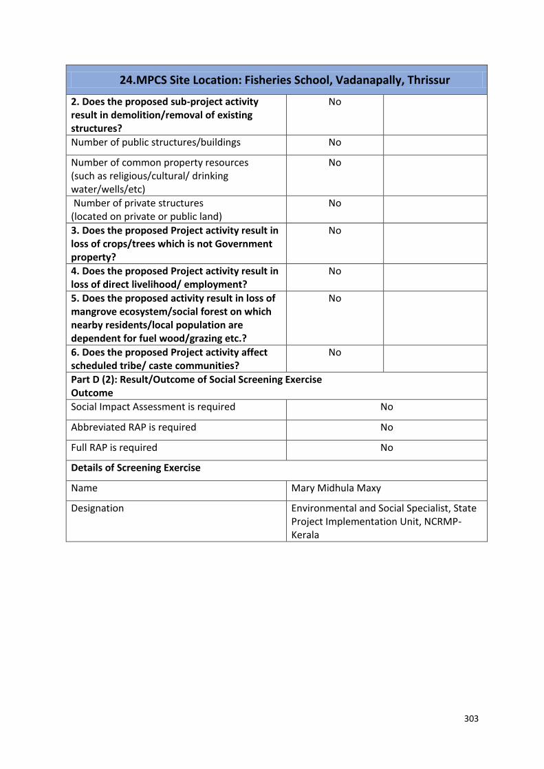
303
24. MPCS Site Location: Fisheries School, Vadanapally, Thrissur
2. Does the proposed sub-project activity result in demolition/removal of existing structures?
No
Number of public structures/buildings No
Number of common property resources (such as religious/cultural/ drinking water/wells/etc)
No
Number of private structures (located on private or public land)
No
3. Does the proposed Project activity result in loss of crops/trees which is not Government property?
No
4. Does the proposed Project activity result in loss of direct livelihood/ employment?
No
5. Does the proposed activity result in loss of mangrove ecosystem/social forest on which nearby residents/local population are dependent for fuel wood/grazing etc.?
No
6. Does the proposed Project activity affect scheduled tribe/ caste communities?
No
Part D (2): Result/Outcome of Social Screening Exercise Outcome
Social Impact Assessment is required No
Abbreviated RAP is required No
Full RAP is required No
Details of Screening Exercise
Name Mary Midhula Maxy
Designation Environmental and Social Specialist, State Project Implementation Unit, NCRMP-Kerala

304
25. MPCS Site Location: TRP Shelter, Kadappuram, Thrissur Part A: General Information about the sub-project
Sub Project id NCRMP/KER/TSR/ CHVD/KADAPPURAM-3
Type of proposed sub-project activity MPCS
Location of the sub project activity
State Kerala
District Thrissur
Taluk Chavakkad
Village Kadappuram
Panchayath/Municipal Corporation Kadappuram Gramapanchayath
Survey Number Survey number: 86/2
Latitude 10⁰ 33' 20.0' N
Longitude 76⁰ 01' 16.9"E
Mean Sea Level 21 m
Size of the sub-project
Cyclone Shelter – approx. built up area
Land requirement for the sub project (in Ha or m2)
Total Requirement
a. Private Land Nil
b. Government Land No area available for construction of MPCS
c. Forest Land Nil
Existing Land use TRP Shelter exists in the site
Approach roads
Road name Tsunami Light House road o
Existing road 1km length and 10m ROW
Proposed road No approach road proposed
Boundary wall requirement No
Part B: Ascertaining whether the site is a prohibited site PART B1: List of sites where sub-projects are prohibited
Is the sub-project located in whole or within any of the following environmentally sensitive area?
Remarks if any
Biosphere reserve No
National Park No
Wildlife/Bird sanctuary No
Game reserve No
Tiger reserve/elephant reserve No
Wetland No
Important bird areas No
Coastal area with corals No
Mangrove area No
Estuary with mangroves No
Turtle nesting grounds No
Swamps/mudflats No
Notified sensitive eco zone No
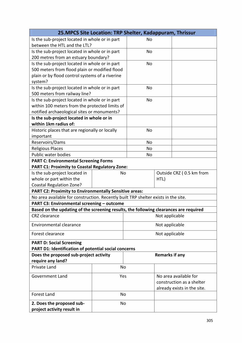
305
25. MPCS Site Location: TRP Shelter, Kadappuram, Thrissur Is the sub-project located in whole or in part between the HTL and the LTL?
No
Is the sub-project located in whole or in part 200 metres from an estuary boundary?
No
Is the sub-project located in whole or in part 500 meters from flood plain or modified flood plain or by flood control systems of a riverine system?
No
Is the sub-project located in whole or in part 500 meters from railway line?
No
Is the sub-project located in whole or in part within 100 meters from the protected limits of notified archaeological sites or monuments?
No
Is the sub-project located in whole or in within 1km radius of:
Historic places that are regionally or locally important
No
Reservoirs/Dams No
Religious Places No
Public water bodies No
PART C: Environmental Screening Forms PART C1: Proximity to Coastal Regulatory Zone:
Is the sub-project located in whole or part within the Coastal Regulation Zone?
No Outside CRZ ( 0.5 km from HTL)
PART C2: Proximity to Environmentally Sensitive areas:
No area available for construction. Recently built TRP shelter exists in the site.
PART C3: Environmental screening – outcome
Based on the updating of the screening results, the following clearances are required
CRZ clearance Not applicable
Environmental clearance Not applicable
Forest clearance Not applicable
PART D: Social Screening PART D1: Identification of potential social concerns
Does the proposed sub-project activity require any land?
Remarks if any
Private Land No
Government Land Yes No area available for construction as a shelter already exists in the site.
Forest Land No
2. Does the proposed sub-project activity result in
No
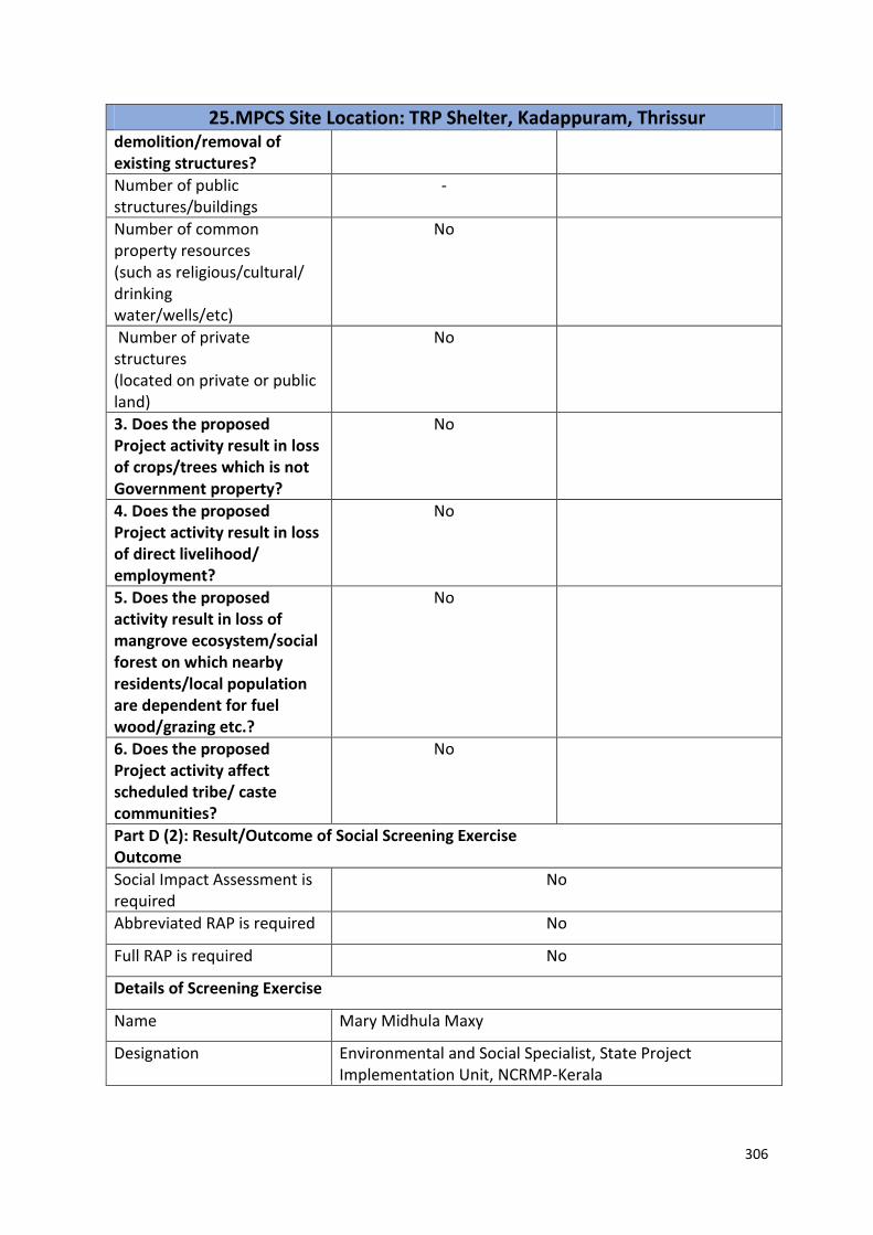
306
25. MPCS Site Location: TRP Shelter, Kadappuram, Thrissur demolition/removal of existing structures?
Number of public structures/buildings
-
Number of common property resources (such as religious/cultural/ drinking water/wells/etc)
No
Number of private structures (located on private or public land)
No
3. Does the proposed Project activity result in loss of crops/trees which is not Government property?
No
4. Does the proposed Project activity result in loss of direct livelihood/ employment?
No
5. Does the proposed activity result in loss of mangrove ecosystem/social forest on which nearby residents/local population are dependent for fuel wood/grazing etc.?
No
6. Does the proposed Project activity affect scheduled tribe/ caste communities?
No
Part D (2): Result/Outcome of Social Screening Exercise Outcome
Social Impact Assessment is required
No
Abbreviated RAP is required No
Full RAP is required No
Details of Screening Exercise
Name Mary Midhula Maxy
Designation Environmental and Social Specialist, State Project Implementation Unit, NCRMP-Kerala

307
26. MPCS Site Location: Edakazhiyoor, Thrissur Part A: General Information about the sub-project
Sub Project id NCRMP/KER/TSR/ CHVD/EDAKAZHIYOOR-1
Type of proposed sub-project activity MPCS
Location of the sub project activity
State Kerala
District Thrissur
Taluk Chavakkad
Village Edakazhiyoor
Panchayath/Municipal Corporation Edakazhiyoor Gramapanchayath
Survey Number Survey number: 132/1
Latitude 10⁰ 37' 16.4”N
Longitude 75⁰ 59' 46.8" E
Mean Sea Level 22 m
Size of the sub-project
Cyclone Shelter – approx. built up area Less than 500 SQ.M
Land requirement for the sub project (in Ha or m2)
Total Requirement
a. Private Land Nil
b. Government Land Less than 500 SQ.M
c. Forest Land Nil
Existing Land use Barren land
Approach roads
Road name National Highway
Existing road The site is directly accessible from NH
Proposed road No approach road proposed
Boundary wall requirement No
Part B: Ascertaining whether the site is a prohibited site PART B1: List of sites where sub-projects are prohibited
Is the sub-project located in whole or within any of the following environmentally sensitive area?
Remarks if any
Biosphere reserve No
National Park No
Wildlife/Bird sanctuary No
Game reserve No
Tiger reserve/elephant reserve No
Wetland No
Important bird areas No
Coastal area with corals No
Mangrove area No
Estuary with mangroves No
Turtle nesting grounds No
Swamps/mudflats No
Notified sensitive eco zone No
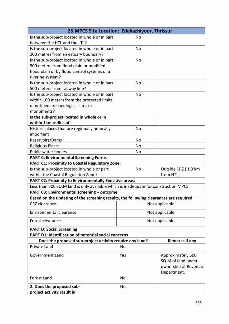
308
26. MPCS Site Location: Edakazhiyoor, Thrissur Is the sub-project located in whole or in part between the HTL and the LTL?
No
Is the sub-project located in whole or in part 200 metres from an estuary boundary?
No
Is the sub-project located in whole or in part 500 meters from flood plain or modified flood plain or by flood control systems of a riverine system?
No
Is the sub-project located in whole or in part 500 meters from railway line?
No
Is the sub-project located in whole or in part within 100 meters from the protected limits of notified archaeological sites or monuments?
No
Is the sub-project located in whole or in within 1km radius of:
Historic places that are regionally or locally important
No
Reservoirs/Dams No
Religious Places No
Public water bodies No
PART C: Environmental Screening Forms PART C1: Proximity to Coastal Regulatory Zone:
Is the sub-project located in whole or part within the Coastal Regulation Zone?
No Outside CRZ ( 1.3 km from HTL)
PART C2: Proximity to Environmentally Sensitive areas:
Less than 500 SQ.M land is only available which is inadequate for construction MPCS.
PART C3: Environmental screening – outcome
Based on the updating of the screening results, the following clearances are required
CRZ clearance Not applicable
Environmental clearance Not applicable
Forest clearance Not applicable
PART D: Social Screening PART D1: Identification of potential social concerns
Does the proposed sub-project activity require any land? Remarks if any
Private Land No
Government Land Yes Approximately 500 SQ.M of land under ownership of Revenue Department.
Forest Land No
2. Does the proposed sub-project activity result in
No

309
26. MPCS Site Location: Edakazhiyoor, Thrissur demolition/removal of existing structures?
Number of public structures/buildings
No
Number of common property resources (such as religious/cultural/ drinking water/wells/etc)
No
Number of private structures (located on private or public land)
No
3. Does the proposed Project activity result in loss of crops/trees which is not Government property?
No
4. Does the proposed Project activity result in loss of direct livelihood/ employment?
No
5. Does the proposed activity result in loss of mangrove ecosystem/social forest on which nearby residents/local population are dependent for fuel wood/grazing etc.?
No
6. Does the proposed Project activity affect scheduled tribe/ caste communities?
No
Part D (2): Result/Outcome of Social Screening Exercise Outcome
Social Impact Assessment is required
No
Abbreviated RAP is required No
Full RAP is required No
Details of Screening Exercise
Name Mary Midhula Maxy
Designation Environmental and Social Specialist, State Project Implementation Unit, NCRMP-Kerala

310
27. MPCS Site Location: School ground, Edavanakad Part A: General Information about the sub-project
Sub Project id NCRMP/KER/EKM/KOC/ EDAVANAKKAD-1
Type of proposed sub-project activity MPCS
Location of the sub project activity
State Kerala
District Ernakulam
Taluk Kochi
Village Edavanakkad
Panchayath/Municipal Corporation Edavanakkad Gramapanchayath
Survey Number Survey number: 237/1 (B4)
Latitude 10⁰ 05’ 03.6”N
Longitude 76⁰ 12’ 35.3”E
Mean Sea Level 15 m
Size of the sub-project
Cyclone Shelter – approx. built up area
Land requirement for the sub project (in Ha or m2)
Total Requirement
a. Private Land Nil
b. Government Land No area available for construction
c. Forest Land Nil
Existing Land use School ground
Approach roads
Road name Panchayath roads
Existing road ROW: 6 m
Proposed road No approach road proposed.
Boundary wall requirement No
Part B: Ascertaining whether the site is a prohibited site PART B1: List of sites where sub-projects are prohibited
Is the sub-project located in whole or within any of the following environmentally sensitive area?
Remarks if any
Biosphere reserve No
National Park No
Wildlife/Bird sanctuary No
Game reserve No
Tiger reserve/elephant reserve No
Wetland No
Important bird areas No
Coastal area with corals No
Mangrove area No
Estuary with mangroves No
Turtle nesting grounds No
Swamps/mudflats No
Notified sensitive eco zone No

311
27. MPCS Site Location: School ground, Edavanakad Is the sub-project located in whole or in part between the HTL and the LTL?
No
Is the sub-project located in whole or in part 200 metres from an estuary boundary?
No
Is the sub-project located in whole or in part 500 meters from flood plain or modified flood plain or by flood control systems of a riverine system?
No
Is the sub-project located in whole or in part 500 meters from railway line?
No
Is the sub-project located in whole or in part within 100 meters from the protected limits of notified archaeological sites or monuments?
No
Is the sub-project located in whole or in within 1km radius of:
Historic places that are regionally or locally important
No
Reservoirs/Dams No
Religious Places No
Public water bodies No
PART C: Environmental Screening Forms PART C1: Proximity to Coastal Regulatory Zone:
Is the sub-project located in whole or part within the Coastal Regulation Zone?
No Outside CRZ ( 4 km from HTL)
PART C2: Proximity to Environmentally Sensitive areas:
Adequate area for construction of MPCS is not available
PART C3: Environmental screening – outcome
Based on the updating of the screening results, the following clearances are required
CRZ clearance Not applicable
Environmental clearance Not applicable
Forest clearance Not applicable
PART D: Social Screening PART D1: Identification of potential social concerns
Does the proposed sub-project activity require any land?
Remarks if any
Private Land No
Government Land - A shelter in good working condition exists in the site and hence there is no need for construction of MPCS
Forest Land No
2. Does the proposed sub-project activity result in
No

312
27. MPCS Site Location: School ground, Edavanakad demolition/removal of existing structures?
Number of public structures/buildings
- A shelter in good working condition exists in the area
demarcated for MPCS.
Number of common property resources (such as religious/cultural/ drinking water/wells/etc)
No
Number of private structures (located on private or public land)
No
3. Does the proposed Project activity result in loss of crops/trees which is not Government property?
No
4. Does the proposed Project activity result in loss of direct livelihood/ employment?
No
5. Does the proposed activity result in loss of mangrove ecosystem/social forest on which nearby residents/local population are dependent for fuel wood/grazing etc.?
No
6. Does the proposed Project activity affect scheduled tribe/ caste communities?
No
Part D (2): Result/Outcome of Social Screening Exercise Outcome
Social Impact Assessment is required
No
Abbreviated RAP is required No
Full RAP is required No
Details of Screening Exercise
Name Mary Midhula Maxy
Designation Environmental and Social Specialist, State Project Implementation Unit, NCRMP-Kerala

313
28. MPCS Site Location: Chavara, Kollam Part A: General Information about the sub-project
Sub Project id NCRMP/KER/KLM/KAR/CHAVARA-1
Type of proposed sub-project activity MPCS
Location of the sub project activity
State Kerala
District Kollam
Taluk Kasrunagappally
Village Chavara
Panchayath/Municipal Corporation Chavara Gramapanchayath
Survey Number Block: 19, Survey number: 392/1
Latitude 8° 59’ 2.3” N
Longitude 76° 32’ 5.6” E
Mean Sea Level 20 m
Size of the sub-project
Cyclone Shelter – approx. built up area Adequate area is not available for construction of MPCS
Land requirement for the sub project (in Ha or m2)
Total Requirement
a. Private Land Nil
b. Government Land Less than 500 SQ.M
c. Forest Land Nil
Existing Land use Barren land
Approach roads
Road name National Highway
Existing road -
Proposed road No approach road proposed
Boundary wall requirement No
Part B: Ascertaining whether the site is a prohibited site PART B1: List of sites where sub-projects are prohibited
Is the sub-project located in whole or within any of the following environmentally sensitive area?
Remarks if any
Biosphere reserve No
National Park No
Wildlife/Bird sanctuary No
Game reserve No
Tiger reserve/elephant reserve No
Wetland No
Important bird areas No
Coastal area with corals No
Mangrove area No
Estuary with mangroves No
Turtle nesting grounds No
Swamps/mudflats No Water logged area

314
28. MPCS Site Location: Chavara, Kollam Notified sensitive eco zone No
Is the sub-project located in whole or in part between the HTL and the LTL?
No
Is the sub-project located in whole or in part 200 metres from an estuary boundary?
No
Is the sub-project located in whole or in part 500 meters from flood plain or modified flood plain or by flood control systems of a riverine system?
No
Is the sub-project located in whole or in part 500 meters from railway line?
No
Is the sub-project located in whole or in part within 100 meters from the protected limits of notified archaeological sites or monuments?
No
Is the sub-project located in whole or in within 1km radius of:
Historic places that are regionally or locally important
No
Reservoirs/Dams No
Religious Places No
Public water bodies No
PART C: Environmental Screening Forms PART C1: Proximity to Coastal Regulatory Zone:
Is the sub-project located in whole or part within the Coastal Regulation Zone?
No Outside CRZ ( 1 km from HTL)
PART C2: Proximity to Environmentally Sensitive areas:
Not applicable as adequate area is not available for construction of MPCS
PART C3: Environmental screening – outcome
Based on the updating of the screening results, the following clearances are required
CRZ clearance Not applicable
Environmental clearance Not applicable
Forest clearance Not applicable
PART D: Social Screening PART D1: Identification of potential social concerns
Does the proposed sub-project activity require any land? Remarks if any
Private Land No
Government Land Yes Less than 400 SQ.M of area is only avaible for construction

315
28. MPCS Site Location: Chavara, Kollam Forest Land No
2. Does the proposed sub-project activity result in demolition/removal of existing structures?
No
Number of public structures/buildings No
Number of common property resources (such as religious/cultural/ drinking water/wells/etc)
No
Number of private structures (located on private or public land)
No
3. Does the proposed Project activity result in loss of crops/trees which is not Government property?
No
4. Does the proposed Project activity result in loss of direct livelihood/ employment?
No
5. Does the proposed activity result in loss of mangrove ecosystem/social forest on which nearby residents/local population are dependent for fuel wood/grazing etc.?
No
6. Does the proposed Project activity affect scheduled tribe/ caste communities?
No
Part D (2): Result/Outcome of Social Screening Exercise Outcome
Social Impact Assessment is required No
Abbreviated RAP is required No
Full RAP is required No
Details of Screening Exercise
Name Mary Midhula Maxy
Designation Environmental and Social Specialist, State Project Implementation Unit, NCRMP-Kerala

316
29. MPCS Site Location: Revenue land, Chavara, Kollam Part A: General Information about the sub-project Sub Project id NCRMP/KER/KLM/KAR/CHAVRA-2
Type of proposed sub-project activity MPCS
Location of the sub project activity
State Kerala District Kollam Taluk Kasrunagappally Village Chavara Panchayath/Municipal Corporation Chavara Gramapanchayath
Survey Number Block: 19, Survey number: 103/15
Latitude 8° 58’ 39.8”N
Longitude 76° 32’ 4.2”E
Mean Sea Level 25 m
Size of the sub-project
Cyclone Shelter – approx. built up area Exact boundary of site is not known
Land requirement for the sub project (in Ha or m2)
Total Requirement
a. Private Land Nil
b. Government Land Exact boundary of site is not known
c. Forest Land Nil
Existing Land use Barren land
Approach roads
Road name National Highway
Existing road -
Proposed road No approach road proposed
Boundary wall requirement No
Part B: Ascertaining whether the site is a prohibited site PART B1: List of sites where sub-projects are prohibited
Is the sub-project located in whole or within any of the following environmentally sensitive area?
Remarks if any
Biosphere reserve No
National Park No
Wildlife/Bird sanctuary No
Game reserve No
Tiger reserve/elephant reserve No
Wetland No
Important bird areas No
Coastal area with corals No
Mangrove area No
Estuary with mangroves No
Turtle nesting grounds No
Swamps/mudflats No
Notified sensitive eco zone No
Is the sub-project located in whole or in part between the HTL and the LTL?
No
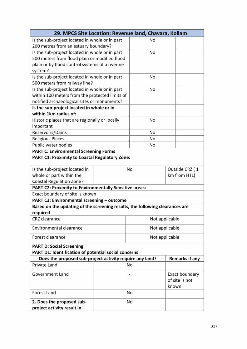
317
29. MPCS Site Location: Revenue land, Chavara, Kollam Is the sub-project located in whole or in part 200 metres from an estuary boundary?
No
Is the sub-project located in whole or in part 500 meters from flood plain or modified flood plain or by flood control systems of a riverine system?
No
Is the sub-project located in whole or in part 500 meters from railway line?
No
Is the sub-project located in whole or in part within 100 meters from the protected limits of notified archaeological sites or monuments?
No
Is the sub-project located in whole or in within 1km radius of:
Historic places that are regionally or locally important
No
Reservoirs/Dams No
Religious Places No
Public water bodies No
PART C: Environmental Screening Forms PART C1: Proximity to Coastal Regulatory Zone:
Is the sub-project located in whole or part within the Coastal Regulation Zone?
No Outside CRZ ( 1 km from HTL)
PART C2: Proximity to Environmentally Sensitive areas:
Exact boundary of site is known
PART C3: Environmental screening – outcome
Based on the updating of the screening results, the following clearances are required
CRZ clearance Not applicable
Environmental clearance Not applicable
Forest clearance Not applicable
PART D: Social Screening PART D1: Identification of potential social concerns
Does the proposed sub-project activity require any land? Remarks if any
Private Land No
Government Land - Exact boundary of site is not known
Forest Land No
2. Does the proposed sub-project activity result in
No

318
29. MPCS Site Location: Revenue land, Chavara, Kollam demolition/removal of existing structures?
Number of public structures/buildings
No
Number of common property resources (such as religious/cultural/ drinking water/wells/etc)
No
Number of private structures (located on private or public land)
No
3. Does the proposed Project activity result in loss of crops/trees which is not Government property?
No
4. Does the proposed Project activity result in loss of direct livelihood/ employment?
No
5. Does the proposed activity result in loss of mangrove ecosystem/social forest on which nearby residents/local population are dependent for fuel wood/grazing etc.?
No
6. Does the proposed Project activity affect scheduled tribe/ caste communities?
No
Part D (2): Result/Outcome of Social Screening Exercise Outcome
Social Impact Assessment is required
No
Abbreviated RAP is required No
Full RAP is required No
Details of Screening Exercise
Name Mary Midhula Maxy
Designation Environmental and Social Specialist, State Project Implementation Unit, NCRMP-Kerala

319
30. MPCS Site Location: Sakthikulangara, Kollam Part A: General Information about the sub-project
Sub Project id NCRMP/KER/KSD/ KAS/KUDLU-1
Type of proposed sub-project activity
MPCS
Location of the sub project activity
State Kerala
District Kasargod
Taluk Kollam
Village Sakthikulangara
Panchayath/Municipal Corporation Kollam Corporation
Survey Number Block 1, Survey number: 1/1, 2
Latitude 8⁰ 55’ 53.69”N
Longitude 76⁰ 32’ 24.94”E
Mean Sea Level 10 m
Size of the sub-project
Cyclone Shelter – approx. built up area
Less than 400 SQ.M of land is only available for construction
Land requirement for the sub project (in Ha or m2)
Total Requirement
g. Private Land Nil
h. Government Land 400 SQ.M
i. Forest Land Nil
Existing Land use Barren land
Approach roads
Road name Sakthikulanagra Port Road
Existing road -
Proposed road No approach road proposed
Boundary wall requirement No
Part B: Ascertaining whether the site is a prohibited site PART B1: List of sites where sub-projects are prohibited
Is the sub-project located in whole or within any of the following environmentally sensitive area?
Remarks if any
Biosphere reserve No
National Park No
Wildlife/Bird sanctuary No
Game reserve No
Tiger reserve/elephant reserve No
Wetland No
Important bird areas No
Coastal area with corals No
Mangrove area No
Estuary with mangroves No
Turtle nesting grounds No
Swamps/mudflats No

320
30. MPCS Site Location: Sakthikulangara, Kollam Notified sensitive eco zone No
Is the sub-project located in whole or in part between the HTL and the LTL?
Yes 100m from the HTL and is bound by sea wall on the west side and has the breakwater to its north. The site is in inundation area
Is the sub-project located in whole or in part 200 metres from an estuary boundary?
No
Is the sub-project located in whole or in part 500 meters from flood plain or modified flood plain or by flood control systems of a riverine system?
-
Is the sub-project located in whole or in part 500 meters from railway line?
No
Is the sub-project located in whole or in part within 100 meters from the protected limits of notified archaeological sites or monuments?
No
Is the sub-project located in whole or in within 1km radius of:
Historic places that are regionally or locally important
No
Reservoirs/Dams No
Religious Places No
Public water bodies No
PART C: Environmental Screening Forms PART C1: Proximity to Coastal Regulatory Zone:
Is the sub-project located in whole or part within the Coastal Regulation Zone?
Yes The site is 100m from the HTL and is bound by sea wall on the west side and has the breakwater to its north.
PART C2: Proximity to Environmentally Sensitive areas:
Not applicable as adequate area is not available for construction of MPCS
PART C3: Environmental screening – outcome
Based on the updating of the screening results, the following clearances are required
CRZ clearance Not applicable
Environmental clearance Not applicable
Forest clearance Not applicable
PART D: Social Screening

321
30. MPCS Site Location: Sakthikulangara, Kollam PART D1: Identification of potential social concerns
1.Does the proposed sub-project activity require any land?
Remarks if any
Private Land No
Government Land - Less than 400 SQ.M of land is only available for construction
Forest Land No
2. Does the proposed sub-project activity result in demolition/removal of existing structures?
No
Number of public structures/buildings
No
Number of common property resources (such as religious/cultural/ drinking water/wells/etc)
No
Number of private structures (located on private or public land)
No
3. Does the proposed Project activity result in loss of crops/trees which is not Government property?
No
4. Does the proposed Project activity result in loss of direct livelihood/ employment?
No
5. Does the proposed activity result in loss of mangrove ecosystem/social forest on which nearby residents/local population are dependent for fuel wood/grazing etc.?
No
6. Does the proposed Project activity affect scheduled tribe/ caste communities?
No
Part D (2): Result/Outcome of Social Screening Exercise Outcome
Social Impact Assessment is required No
Abbreviated RAP is required No
Full RAP is required No

322
30. MPCS Site Location: Sakthikulangara, Kollam Details of Screening Exercise
Name Mary Midhula Maxy
Designation Environmental and Social Specialist, State Project Implementation Unit, NCRMP-Kerala

323
31. MPCS Site Location: Chavara Taluk hospital, Neendakara Part A: General Information about the sub-project
Sub Project id NCRMP/KER/KLM/KAR/NEENDAKARA-1
Type of proposed sub-project activity MPCS
Location of the sub project activity
State Kerala
District Kollam
Taluk Karunagappally
Village Neendakara
Panchayath/Municipal Corporation Neendakara Gramapanchayath
Survey Number Block 22, Survey number: 105/6
Latitude 8⁰ 57' 30.460'N
Longitude 76⁰ 31' 56.846"E
Mean Sea Level 24 m
Size of the sub-project
Cyclone Shelter – approx. built up area Only 405 SQ.M of land is available for construction
Land requirement for the sub project (in Ha or m2)
Total Requirement
a. Private Land Nil
b. Government Land Only 405 SQ.M of land is available for construction
c. Forest Land Nil
Existing Land use Dilapidated Buildings
Approach roads
Road name National Highway
Existing road The site is directly accessible from NH
Proposed road No approach road proposed.
Boundary wall requirement No
Part B: Ascertaining whether the site is a prohibited site PART B1: List of sites where sub-projects are prohibited
Is the sub-project located in whole or within any of the following environmentally sensitive area?
Remarks if any
Biosphere reserve No
National Park No
Wildlife/Bird sanctuary No
Game reserve No
Tiger reserve/elephant reserve No
Wetland No
Important bird areas No
Coastal area with corals No
Mangrove area No
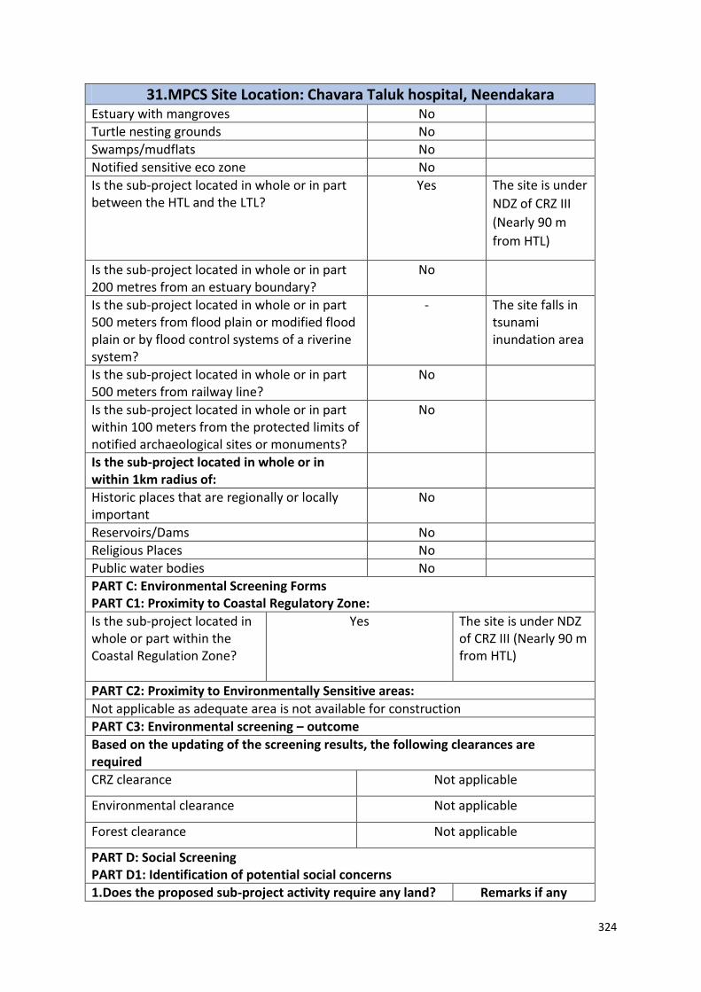
324
31. MPCS Site Location: Chavara Taluk hospital, Neendakara Estuary with mangroves No
Turtle nesting grounds No
Swamps/mudflats No
Notified sensitive eco zone No
Is the sub-project located in whole or in part between the HTL and the LTL?
Yes The site is under
NDZ of CRZ III
(Nearly 90 m
from HTL)
Is the sub-project located in whole or in part 200 metres from an estuary boundary?
No
Is the sub-project located in whole or in part 500 meters from flood plain or modified flood plain or by flood control systems of a riverine system?
-
The site falls in tsunami inundation area
Is the sub-project located in whole or in part 500 meters from railway line?
No
Is the sub-project located in whole or in part within 100 meters from the protected limits of notified archaeological sites or monuments?
No
Is the sub-project located in whole or in within 1km radius of:
Historic places that are regionally or locally important
No
Reservoirs/Dams No
Religious Places No
Public water bodies No
PART C: Environmental Screening Forms PART C1: Proximity to Coastal Regulatory Zone:
Is the sub-project located in whole or part within the Coastal Regulation Zone?
Yes The site is under NDZ of CRZ III (Nearly 90 m from HTL)
PART C2: Proximity to Environmentally Sensitive areas:
Not applicable as adequate area is not available for construction
PART C3: Environmental screening – outcome
Based on the updating of the screening results, the following clearances are required
CRZ clearance Not applicable
Environmental clearance Not applicable
Forest clearance Not applicable
PART D: Social Screening PART D1: Identification of potential social concerns
1.Does the proposed sub-project activity require any land? Remarks if any

325
31. MPCS Site Location: Chavara Taluk hospital, Neendakara Private Land No
Government Land Yes Less than 400 SQ.M of land under ownership of Revenue Department.
Forest Land No
2. Does the proposed sub-project activity result in demolition/removal of existing structures?
No
Number of public structures/buildings
3 (Three) The land is occupied
by three dilapidated
buildings, constructed
under the Norwegian
Government funded
project.
Number of common property resources (such as religious/cultural/ drinking water/wells/etc)
No
Number of private structures (located on private or public land)
No
3. Does the proposed Project activity result in loss of crops/trees which is not Government property?
No
4. Does the proposed Project activity result in loss of direct livelihood/ employment?
No
5. Does the proposed activity result in loss of mangrove ecosystem/social forest on which nearby residents/local population are dependent for fuel wood/grazing etc.?
No
6. Does the proposed Project activity affect scheduled tribe/ caste communities?
No
Part D (2): Result/Outcome of Social Screening Exercise Outcome

326
31. MPCS Site Location: Chavara Taluk hospital, Neendakara Social Impact Assessment is required
No
Abbreviated RAP is required No
Full RAP is required No
Details of Screening Exercise
Name Mary Midhula Maxy
Designation Environmental and Social Specialist, State Project Implementation Unit, NCRMP-Kerala

327
32. MPCS Site Location: Old Dilapidated building, Alappadu Part A: General Information about the sub-project Sub Project id NCRMP/KER/KLM/KAR/ALAPPADU-1 Type of proposed sub-project activity MPCS
Location of the sub project activity State Kerala
District Kollam
Taluk Karunagappally
Village Alappadu
Panchayath/Municipal Corporation Alappadu Gramapanchayath
Survey Number Block 7, Survey number: 61/8
Latitude 9⁰ 04’ 05.260”N
Longitude 76⁰ 29’ 44.929” E
Mean Sea Level 15 m
Size of the sub-project
Cyclone Shelter – approx. built up area Site not suitable for construction of
MPCS
Land requirement for the sub project (in Ha or m2)
Total Requirement
d. Private Land Nil
e. Government Land 500 SQ.M
f. Forest Land Nil
Existing Land use Barren land
Approach roads
Road name Panchayath roads
Existing road ROW: 4m
Proposed road No approach road proposed
Boundary wall requirement No
Part B: Ascertaining whether the site is a prohibited site
PART B1: List of sites where sub-projects are prohibited
Is the sub-project located in whole or within any of the
following environmentally sensitive area?
Remarks if any
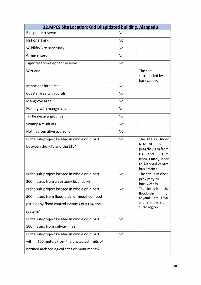
328
32. MPCS Site Location: Old Dilapidated building, Alappadu Biosphere reserve No
National Park No
Wildlife/Bird sanctuary No
Game reserve No
Tiger reserve/elephant reserve No
Wetland - The site is surrounded by backwaters.
Important bird areas No
Coastal area with corals No
Mangrove area No
Estuary with mangroves No
Turtle nesting grounds No
Swamps/mudflats No
Notified sensitive eco zone No
Is the sub-project located in whole or in part
between the HTL and the LTL?
No The site is Under NDZ of CRZ III. (Nearly 90 m from HTL and 110 m from Canal, near to Alappad centre bus Station)
Is the sub-project located in whole or in part
200 metres from an estuary boundary?
No The site is in close proximity to backwaters
Is the sub-project located in whole or in part
500 meters from flood plain or modified flood
plain or by flood control systems of a riverine
system?
No
The site falls in the floodplain of Kayamkulam kayal and is in the storm surge region.
Is the sub-project located in whole or in part
500 meters from railway line?
No
Is the sub-project located in whole or in part
within 100 meters from the protected limits of
notified archaeological sites or monuments?
No
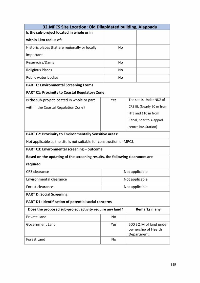
329
32. MPCS Site Location: Old Dilapidated building, Alappadu Is the sub-project located in whole or in
within 1km radius of:
Historic places that are regionally or locally
important
No
Reservoirs/Dams No
Religious Places No
Public water bodies No
PART C: Environmental Screening Forms
PART C1: Proximity to Coastal Regulatory Zone:
Is the sub-project located in whole or part
within the Coastal Regulation Zone?
Yes The site is Under NDZ of
CRZ III. (Nearly 90 m from
HTL and 110 m from
Canal, near to Alappad
centre bus Station)
PART C2: Proximity to Environmentally Sensitive areas:
Not applicable as the site is not suitable for construction of MPCS.
PART C3: Environmental screening – outcome
Based on the updating of the screening results, the following clearances are
required
CRZ clearance Not applicable
Environmental clearance Not applicable
Forest clearance Not applicable
PART D: Social Screening
PART D1: Identification of potential social concerns
Does the proposed sub-project activity require any land? Remarks if any
Private Land No
Government Land Yes 500 SQ.M of land under ownership of Health Department.
Forest Land No

330
32. MPCS Site Location: Old Dilapidated building, Alappadu 2. Does the proposed sub-project activity
result in demolition/removal of existing
structures?
Yes A dilapidated building that belongs to health department exists in
the site
Number of public structures/buildings No
Number of common property resources
(such as religious/cultural/ drinking
water/wells/etc)
No
Number of private structures (located on
private or public land)
No
3. Does the proposed Project activity result
in loss of crops/trees which is not
Government property?
No
4. Does the proposed Project activity result
in loss of direct livelihood/ employment?
No
5. Does the proposed activity result in loss
of mangrove ecosystem/social forest on
which nearby residents/local population
are dependent for fuel wood/grazing etc.?
No
6. Does the proposed Project activity affect
scheduled tribe/ caste communities?
No
Part D (2): Result/Outcome of Social Screening Exercise
Outcome
Social Impact Assessment is required No
Abbreviated RAP is required No
Full RAP is required No
Details of Screening Exercise
Name Mary Midhula Maxy
Designation Environmental and Social Specialist,
State Project Implementation Unit,
NCRMP-Kerala

331
33. MPCS Site Location: Old Dilapidated building, Alappadu Part A: General Information about the sub-project
Sub Project id NCRMP/KER/KLM/KAR/ALAPPADU-2
Type of proposed sub-project activity MPCS
Location of the sub project activity
State Kerala
District Kasargod
Taluk Karunagappally
Village Alappadu
Panchayath/Municipal Corporation Alappadu Gramapanchayath
Survey Number Block 1, Survey number: 10/10
Latitude 9⁰ 04’ 05.260”N
Longitude 76⁰ 29’ 44.929” E
Mean Sea Level 11 m
Size of the sub-project
Cyclone Shelter – approx. built up area Site is not suitable for construction of MPCS
Land requirement for the sub project (in Ha or m2)
Total Requirement
d. Private Land Nil
e. Government Land 500 SQ.M
f. Forest Land Nil
Existing Land use Pump House exists in the site
Approach roads
Road name Panchayath roads
Existing road -
Proposed road No approach road proposed
Boundary wall requirement No
Part B: Ascertaining whether the site is a prohibited site PART B1: List of sites where sub-projects are prohibited
Is the sub-project located in whole or within any of the following environmentally sensitive area?
Remarks if any
Biosphere reserve No
National Park No
Wildlife/Bird sanctuary No
Game reserve No
Tiger reserve/elephant reserve No
Wetland No
Important bird areas No
Coastal area with corals No
Mangrove area Yes
Estuary with mangroves No
Turtle nesting grounds No
Swamps/mudflats No
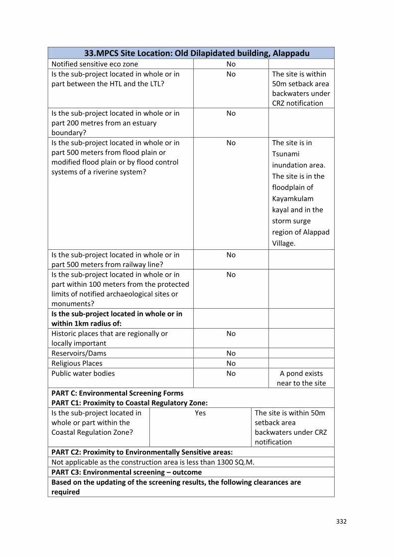
332
33. MPCS Site Location: Old Dilapidated building, Alappadu Notified sensitive eco zone No
Is the sub-project located in whole or in part between the HTL and the LTL?
No The site is within 50m setback area backwaters under CRZ notification
Is the sub-project located in whole or in part 200 metres from an estuary boundary?
No
Is the sub-project located in whole or in part 500 meters from flood plain or modified flood plain or by flood control systems of a riverine system?
No
The site is in
Tsunami
inundation area.
The site is in the
floodplain of
Kayamkulam
kayal and in the
storm surge
region of Alappad
Village.
Is the sub-project located in whole or in part 500 meters from railway line?
No
Is the sub-project located in whole or in part within 100 meters from the protected limits of notified archaeological sites or monuments?
No
Is the sub-project located in whole or in within 1km radius of:
Historic places that are regionally or locally important
No
Reservoirs/Dams No
Religious Places No
Public water bodies No A pond exists near to the site
PART C: Environmental Screening Forms PART C1: Proximity to Coastal Regulatory Zone:
Is the sub-project located in whole or part within the Coastal Regulation Zone?
Yes The site is within 50m setback area backwaters under CRZ notification
PART C2: Proximity to Environmentally Sensitive areas:
Not applicable as the construction area is less than 1300 SQ.M.
PART C3: Environmental screening – outcome
Based on the updating of the screening results, the following clearances are required
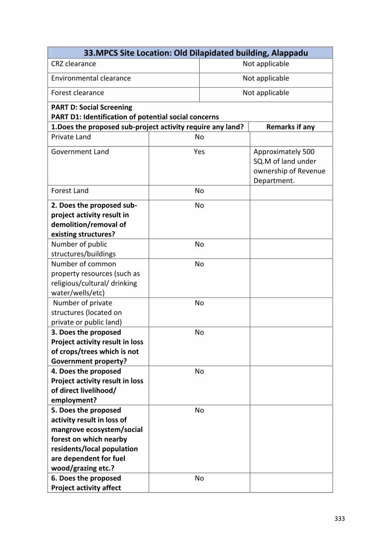
333
33. MPCS Site Location: Old Dilapidated building, Alappadu CRZ clearance Not applicable
Environmental clearance Not applicable
Forest clearance Not applicable
PART D: Social Screening PART D1: Identification of potential social concerns
1.Does the proposed sub-project activity require any land? Remarks if any
Private Land No
Government Land Yes Approximately 500 SQ.M of land under ownership of Revenue Department.
Forest Land No
2. Does the proposed sub-project activity result in demolition/removal of existing structures?
No
Number of public structures/buildings
No
Number of common property resources (such as religious/cultural/ drinking water/wells/etc)
No
Number of private structures (located on private or public land)
No
3. Does the proposed Project activity result in loss of crops/trees which is not Government property?
No
4. Does the proposed Project activity result in loss of direct livelihood/ employment?
No
5. Does the proposed activity result in loss of mangrove ecosystem/social forest on which nearby residents/local population are dependent for fuel wood/grazing etc.?
No
6. Does the proposed Project activity affect
No
334
33. MPCS Site Location: Old Dilapidated building, Alappadu scheduled tribe/ caste communities?
Part D (2): Result/Outcome of Social Screening Exercise Outcome
Social Impact Assessment is required
No
Abbreviated RAP is required No
Full RAP is required No
Details of Screening Exercise
Name Mary Midhula Maxy
Designation Environmental and Social Specialist, State Project Implementation Unit, NCRMP-Kerala
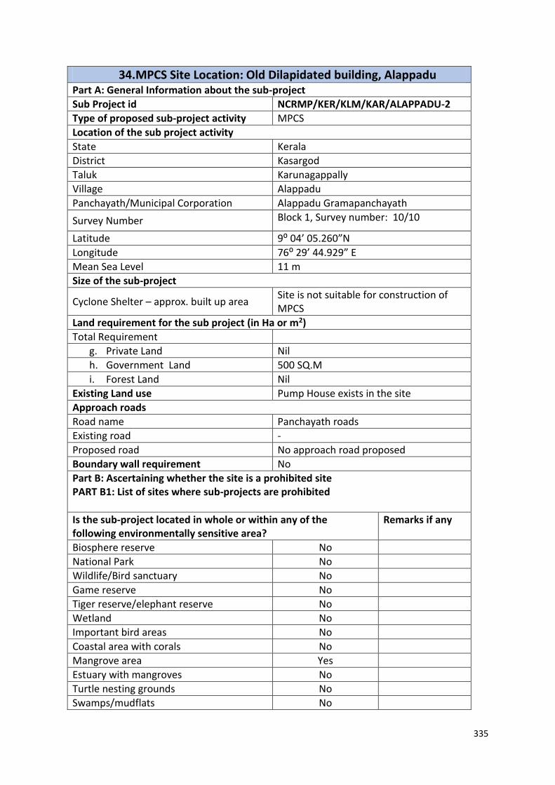
335
34. MPCS Site Location: Old Dilapidated building, Alappadu Part A: General Information about the sub-project
Sub Project id NCRMP/KER/KLM/KAR/ALAPPADU-2
Type of proposed sub-project activity MPCS
Location of the sub project activity
State Kerala
District Kasargod
Taluk Karunagappally
Village Alappadu
Panchayath/Municipal Corporation Alappadu Gramapanchayath
Survey Number Block 1, Survey number: 10/10
Latitude 9⁰ 04’ 05.260”N
Longitude 76⁰ 29’ 44.929” E
Mean Sea Level 11 m
Size of the sub-project
Cyclone Shelter – approx. built up area Site is not suitable for construction of MPCS
Land requirement for the sub project (in Ha or m2)
Total Requirement
g. Private Land Nil
h. Government Land 500 SQ.M
i. Forest Land Nil
Existing Land use Pump House exists in the site
Approach roads
Road name Panchayath roads
Existing road -
Proposed road No approach road proposed
Boundary wall requirement No
Part B: Ascertaining whether the site is a prohibited site PART B1: List of sites where sub-projects are prohibited
Is the sub-project located in whole or within any of the following environmentally sensitive area?
Remarks if any
Biosphere reserve No
National Park No
Wildlife/Bird sanctuary No
Game reserve No
Tiger reserve/elephant reserve No
Wetland No
Important bird areas No
Coastal area with corals No
Mangrove area Yes
Estuary with mangroves No
Turtle nesting grounds No
Swamps/mudflats No

336
34. MPCS Site Location: Old Dilapidated building, Alappadu Notified sensitive eco zone No
Is the sub-project located in whole or in part between the HTL and the LTL?
No The site is within 50m setback area backwaters under CRZ notification
Is the sub-project located in whole or in part 200 metres from an estuary boundary?
No
Is the sub-project located in whole or in part 500 meters from flood plain or modified flood plain or by flood control systems of a riverine system?
No
The site is in
Tsunami
inundation area.
The site is in the
floodplain of
Kayamkulam
kayal and in the
storm surge
region of Alappad
Village.
Is the sub-project located in whole or in part 500 meters from railway line?
No
Is the sub-project located in whole or in part within 100 meters from the protected limits of notified archaeological sites or monuments?
No
Is the sub-project located in whole or in within 1km radius of:
Historic places that are regionally or locally important
No
Reservoirs/Dams No
Religious Places No
Public water bodies No A pond exists near to the site
PART C: Environmental Screening Forms PART C1: Proximity to Coastal Regulatory Zone:
Is the sub-project located in whole or part within the Coastal Regulation Zone?
Yes The site is within 50m setback area backwaters under CRZ notification
PART C2: Proximity to Environmentally Sensitive areas:
Not applicable as the construction area is less than 1300 SQ.M.
PART C3: Environmental screening – outcome
Based on the updating of the screening results, the following clearances are required

337
34. MPCS Site Location: Old Dilapidated building, Alappadu CRZ clearance Not applicable
Environmental clearance Not applicable
Forest clearance Not applicable
PART D: Social Screening PART D1: Identification of potential social concerns
1.Does the proposed sub-project activity require any land? Remarks if any
Private Land No
Government Land Yes Approximately 500 SQ.M of land under ownership of Revenue Department.
Forest Land No
2. Does the proposed sub-project activity result in demolition/removal of existing structures?
No
Number of public structures/buildings
No
Number of common property resources (such as religious/cultural/ drinking water/wells/etc)
No
Number of private structures (located on private or public land)
No
3. Does the proposed Project activity result in loss of crops/trees which is not Government property?
No
4. Does the proposed Project activity result in loss of direct livelihood/ employment?
No
5. Does the proposed activity result in loss of mangrove ecosystem/social forest on which nearby residents/local population are dependent for fuel wood/grazing etc.?
No
6. Does the proposed Project activity affect
No
338
34. MPCS Site Location: Old Dilapidated building, Alappadu scheduled tribe/ caste communities?
Part D (2): Result/Outcome of Social Screening Exercise Outcome
Social Impact Assessment is required
No
Abbreviated RAP is required No
Full RAP is required No
Details of Screening Exercise
Name Mary Midhula Maxy
Designation Environmental and Social Specialist, State Project Implementation Unit, NCRMP-Kerala

339
35. MPCS Site location: Revenue land, Ottoor Part A: General Information about the sub-project
Sub Project id NCRMP/KER/TVM/VAR/OTTOR-1
Type of proposed sub-project activity MPCS
Location of the sub project activity
State Kerala
District Trivandrum
Taluk Varkala
Village Ottoor
Panchayath/Municipal Corporation Ottoor Panchayath
Survey Number Block: 19. Survey Number: 4/1
Latitude 8⁰45’6.0”N
Longitude 76⁰46’10.8”E
Size of the sub-project
Cyclone Shelter – approx. built up area 1000 SQ.M
Land requirement for the sub project (in Ha or m2)
Total Requirement
a. Private Land Nil
b. Government Land 1000 SQ.M of land under the ownership of Revenue Department
c. Forest Land Nil
Existing Land use Uninhabited hilly terrain
Approach roads
Road name A tarred approach road from Varkala- Kallambalam main road to site.
Existing road Length: 100m ROW: 4m
Proposed road No approach road proposed
Boundary wall requirement Yes
Part B: Ascertaining whether the site is a prohibited site PART B1: List of sites where sub-projects are prohibited
Is the sub-project located in whole or within any of the following environmentally sensitive area?
Remarks if any
Biosphere reserve No
National Park No
Wildlife/Bird sanctuary No
Game reserve No
Tiger reserve/elephant reserve No
Wetland No
Important bird areas No
Coastal area with corals No
Mangrove area No
Estuary with mangroves No
Turtle nesting grounds No
Swamps/mudflats No

340
35. MPCS Site location: Revenue land, Ottoor Notified sensitive eco zone No
Is the sub-project located in whole or in part between the HTL and the LTL?
No
Is the sub-project located in whole or in part 200 metres from an estuary boundary?
No
Is the sub-project located in whole or in part 500 meters from flood plain or modified flood plain or by flood control systems of a riverine system?
No
Is the sub-project located in whole or in part 500 meters from railway line?
No
Is the sub-project located in whole or in part within 100 meters from the protected limits of notified archaeological sites or monuments?
No
Is the sub-project located in whole or in within 1km radius of:
Historic places that are regionally or locally important
No
Reservoirs/Dams No
Religious Places No
Public water bodies Yes One water well exist near the site
PART C: Environmental Screening Form PART C1: Proximity to Coastal Regulatory Zone:
Is the sub-project located in whole or part within the Coastal Regulation Zone?
No
PART C2: Proximity to Environmentally Sensitive areas:
Not applicable as the construction area is less than 1000 SQ.M.
PART C3: Environmental screening – outcome Screening outcome
Based on the updating of the screening results, the following clearances are required
CRZ clearance Not applicable
Environmental clearance Not applicable
Forest clearance Not applicable
PART D: Social Screening PART D1: Identification of potential social concerns
1. Does the proposed sub-project activity require any land?
Yes
Private Land No
Government Land Approximately 1000 SQ.M of land under ownership of Revenue Department.
Forest Land No

341
35. MPCS Site location: Revenue land, Ottoor 2. Does the proposed sub-project activity result in demolition/removal of existing structures?
No
Number of public structures/buildings No
Number of common property resources (such as religious/cultural/ drinking water/wells/etc)
Yes. One well exists near the proposed site
Number of private structures (located on private or public land)
No
3. Does the proposed Project activity result in loss of crops/trees which is not Government property?
No
4. Does the proposed Project activity result in loss of direct livelihood/ employment?
No
5. Does the proposed activity result in loss of mangrove ecosystem/social forest on which nearby residents/local population are dependent for fuel wood/grazing etc.?
No
6. Does the proposed Project activity affect scheduled tribe/ caste communities?
No
Part D (2): Result/Outcome of Social Screening Exercise Outcome
Social Impact Assessment is required No
Abbreviated RAP is required No
Full RAP is required No
Details of Screening Exercise
Name Mary Midhula Maxy
Designation Environmental and Social Specialist, State Project Implementation Unit

342
36. MPCS at Chirayinkeezh, Thiruvananthapuram Part A: General Information about the sub-project
Sub Project id NCRMP/KER/TVM/CHI/CHI/1
Type of proposed sub-project activity MPCS and approach roads
Location of the sub project activity
State Kerala
District Trivandrum
Taluk Chirayinkeezh
Village Sarkara Chirayinkeezh
Panchayath/Municipal Corporation Chirayinkeezh Panchayath
Survey Number Block 12, Survey no: 726/7 and 10
Latitude 8⁰39’53.2”N
Longitude 76⁰47’11.3”E
Size of the sub-project
Cyclone Shelter – approx. built up area 600 SQ.M
Land requirement for the sub project (in Ha or m2)
Total Requirement
a. Private Land Nil
b. Government Land 600 SQ.M of land in the ownership of Education Department
c. Forest Land Nil
Existing Land use A dilapidated shelter exists in the site
Approach roads
Road name Padanilom School road
Existing road -
Proposed road No Approach roads proposed
Boundary wall requirement Yes
Part B: Ascertaining whether the site is a prohibited site
PART B1: List of sites where sub-projects are prohibited
Is the sub-project located in whole or in part of any of the following environmentally sensitive areas:
Remarks if any
Biosphere reserve No
National Park No
Wildlife/Bird sanctuary No
Game reserve No
Tiger reserve/elephant reserve No
Wetland No
Important bird areas No
Coastal area with corals No
Mangrove area No
Estuary with mangroves No
Turtle nesting grounds No
Swamps/mudflats No
Notified sensitive eco zone No

343
36. MPCS at Chirayinkeezh, Thiruvananthapuram Is the sub-project located in whole or in part between the HTL and the LTL?
No
Is the sub-project located in whole or in part 200 metres from an estuary boundary?
No
Is the sub-project located in whole or in part 500 meters from flood plain or modified flood plain or by flood control systems of a riverine system?
No
Is the sub-project located in whole or in part 500 meters from railway line?
No
Is the sub-project located in whole or in part within 100 meters from the protected limits of notified archaeological sites or monuments?
No
Is the sub-project located in whole or in within 1km radius of:
Historic places that are regionally or locally important
No
Reservoirs/Dams No
Religious Places No
Public water bodies No
PART C: Environmental Screening Form
PART C1: Proximity to Coastal Regulatory Zone:
Is the sub-project located in whole or part within the Coastal Regulation Zone?
No
PART C2: Proximity to environmentally sensitive areas:
Not applicable as the construction area is only 600 SQ.M.
PART C3: Environmental screening – outcome
Screening outcome
Based on the updating of the screening results, the following clearances are required
Remarks if any
CRZ clearance No
Environmental clearance No
Forest clearance No
PART D: Social Screening
PART D1: Identification of potential social concerns
1. Does the proposed sub-project activity require any land?
Yes
Private Land No
Govt. Revenue Land Yes 600 SQ.M of land in ownership of Education Department.

344
36. MPCS at Chirayinkeezh, Thiruvananthapuram Forest Land No
2. Does the proposed sub-project activity result in demolition/removal of existing structures?
Number of public structures/buildings 2 (Two)
[One dilapidated Anti Disaster shelter and one lavatory building has to
be demolished to facilitate construction in
the proposed site]
Number of common property resources (such as religious/cultural/ drinking water/wells/etc)
No
Number of private structures (located on private or public land)
No
3. Does the proposed Project activity result in loss of crops/trees which is not Government property?
No
4. Does the proposed Project activity result in loss of direct livelihood/ employment?
No
5. Does the proposed activity result in loss of mangrove ecosystem/social forest on which near by residents/local population are dependent for fuel wood/grazing etc.?
No
6. Does the proposed Project activity affect scheduled tribe/ caste communities?
No
Part D (2): Outcome of Social Screening Exercise
Outcome
Social Impact Assessment is required No
Abbreviated RAP is required No
Full RAP is required No
Details of Screening Exercise
Name Mary Midhula Maxy
Designation Environmental and Social Specialist, State Project Implementation Unit

345
37. MPCS at Azhoor, Thiruvananthapuram Part A: General Information about the sub-project
Sub Project id NCRMP/KER/TVM/CHI/AZHOOR-1
Type of proposed sub-project activity MPCS
Location of the sub project activity
State Kerala
District Trivandrum
Taluk Chirayinkeezh
Village Azhoor
Panchayath/Municipal Corporation
Survey Number Block: 14, Survey number: 439/1
Latitude 8⁰37’54.3”N
Longitude 76⁰49’55.8”E
Size of the sub-project
Cyclone Shelter – approx. built up area 1000 SQ.M
Land requirement for the sub project (in Ha or m2)
Total Requirement
a. Private Land Nil
b. Government Land 1000 SQ.M of land in the ownership of Revenue Department
c. Forest Land Nil
Existing Land use Barren land
Approach roads
Road name Untarred approach roads from Main road
Existing road
Proposed road No Approach roads proposed
Boundary wall requirement No Part B: Ascertaining whether the site is a prohibited site PART B1: List of sites where sub-projects are prohibited
Is the sub-project located in whole or in part of any of the following environmentally sensitive areas:
Remarks if any
Biosphere reserve No
National Park No
Wildlife/Bird sanctuary No
Game reserve No
Tiger reserve/elephant reserve No
Wetland No
Important bird areas No
Coastal area with corals No
Mangrove area No
Estuary with mangroves No
Turtle nesting grounds No
Swamps/mudflats No
Notified sensitive eco zone No

346
37. MPCS at Azhoor, Thiruvananthapuram Is the sub-project located in whole or in part between the HTL and the LTL?
No
Is the sub-project located in whole or in part 200 metres from an estuary boundary?
No
Is the sub-project located in whole or in part 500 meters from flood plain or modified flood plain or by flood control systems of a riverine system?
No
Is the sub-project located in whole or in part 500 meters from railway line?
No
Is the sub-project located in whole or in part within 100 meters from the protected limits of notified archaeological sites or monuments?
No
Is the sub-project located in whole or in within 1km radius of:
Historic places that are regionally or locally important
No
Reservoirs/Dams No
Religious Places No
Public water bodies No
PART C: Environmental Screening Form
PART C1: Proximity to Coastal Regulatory Zone:
Is the sub-project located in whole or part within the Coastal Regulation Zone?
No
Outside CRZ (the site is 3km from coastline)
PART C2: Proximity to environmentally sensitive areas:
Not applicable as the construction area is less than 500 SQ.M.
PART C3: Environmental screening – outcome
Screening outcome
Based on the updating of the screening results, the following clearances are required
CRZ clearance No
EIA No
Forest clearance No
Social Forestry Yes [Clearance required from Social Forestry Department for cutting trees, The Kerala Preservation of Trees act, 1986]
PART D: Social Screening
PART D1: Identification of potential social concerns
1. Does the proposed sub-project activity require any land?
Yes
Private Land No
Government Land 600 SQ.M of land in ownership of Revenue
Department
347
37. MPCS at Azhoor, Thiruvananthapuram Forest Land No
2. Does the proposed sub-project activity result in demolition/removal of existing structures?
Number of public structures/buildings
1 (0ne) [(Anti disaster shelter constructed under
European economic Community project)
Number of common property resources (such as religious/cultural/ drinking water/wells/etc)
No
Number of private structures (located on private or public land)
No
3. Does the proposed Project activity result in loss of crops/trees which is not Government property?
No
4. Does the proposed Project activity result in loss of direct livelihood/ employment?
No
5. Does the proposed activity result in loss of mangrove ecosystem/social forest on which near by residents/local population are dependent for fuel wood/grazing etc.?
No
6. Does the proposed Project activity affect scheduled tribe/ caste communities?
No
Part D (2): Result/Outcome of Social Screening Exercise
Outcome
Social Impact Assessment is required No
Abbreviated RAP is required No
Full RAP is required No
Details of Screening Exercise
Name Mary Midhula Maxy
Designation Environmental and Social Specialist, State Project Implementation Unit

348
38. MPCS Site Location: Old Dilapidated building, Alappadu Part A: General Information about the sub-project
Sub Project id NCRMP/KER/KLM/KAR/ALAPPADU-2
Type of proposed sub-project activity MPCS
Location of the sub project activity
State Kerala
District Kasargod
Taluk Karunagappally
Village Alappadu
Panchayath/Municipal Corporation Alappadu Gramapanchayath
Survey Number Block 1, Survey number: 10/10
Latitude 9⁰ 04’ 05.260”N
Longitude 76⁰ 29’ 44.929” E
Mean Sea Level 11 m
Size of the sub-project
Cyclone Shelter – approx. built up area Site is not suitable for construction of MPCS
Land requirement for the sub project (in Ha or m2)
Total Requirement
j. Private Land Nil
k. Government Land 500 SQ.M
l. Forest Land Nil
Existing Land use Pump House exists in the site
Approach roads
Road name Panchayath roads
Existing road -
Proposed road No approach road proposed
Boundary wall requirement No
Part B: Ascertaining whether the site is a prohibited site PART B1: List of sites where sub-projects are prohibited
Is the sub-project located in whole or within any of the following environmentally sensitive area?
Remarks if any
Biosphere reserve No
National Park No
Wildlife/Bird sanctuary No
Game reserve No
Tiger reserve/elephant reserve No
Wetland No
Important bird areas No
Coastal area with corals No
Mangrove area Yes
Estuary with mangroves No
Turtle nesting grounds No
Swamps/mudflats No
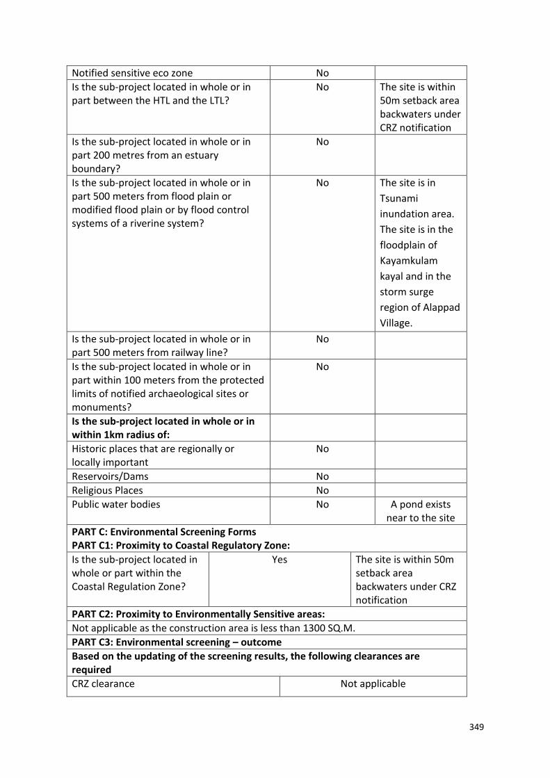
349
Notified sensitive eco zone No
Is the sub-project located in whole or in part between the HTL and the LTL?
No The site is within 50m setback area backwaters under CRZ notification
Is the sub-project located in whole or in part 200 metres from an estuary boundary?
No
Is the sub-project located in whole or in part 500 meters from flood plain or modified flood plain or by flood control systems of a riverine system?
No
The site is in
Tsunami
inundation area.
The site is in the
floodplain of
Kayamkulam
kayal and in the
storm surge
region of Alappad
Village.
Is the sub-project located in whole or in part 500 meters from railway line?
No
Is the sub-project located in whole or in part within 100 meters from the protected limits of notified archaeological sites or monuments?
No
Is the sub-project located in whole or in within 1km radius of:
Historic places that are regionally or locally important
No
Reservoirs/Dams No
Religious Places No
Public water bodies No A pond exists near to the site
PART C: Environmental Screening Forms PART C1: Proximity to Coastal Regulatory Zone:
Is the sub-project located in whole or part within the Coastal Regulation Zone?
Yes The site is within 50m setback area backwaters under CRZ notification
PART C2: Proximity to Environmentally Sensitive areas:
Not applicable as the construction area is less than 1300 SQ.M.
PART C3: Environmental screening – outcome
Based on the updating of the screening results, the following clearances are required
CRZ clearance Not applicable

350
Environmental clearance Not applicable
Forest clearance Not applicable
PART D: Social Screening PART D1: Identification of potential social concerns
1.Does the proposed sub-project activity require any land? Remarks if any
Private Land No
Government Land Yes Approximately 500 SQ.M of land under ownership of Revenue Department.
Forest Land No
2. Does the proposed sub-project activity result in demolition/removal of existing structures?
No
Number of public structures/buildings
No
Number of common property resources (such as religious/cultural/ drinking water/wells/etc)
No
Number of private structures (located on private or public land)
No
3. Does the proposed Project activity result in loss of crops/trees which is not Government property?
No
4. Does the proposed Project activity result in loss of direct livelihood/ employment?
No
5. Does the proposed activity result in loss of mangrove ecosystem/social forest on which nearby residents/local population are dependent for fuel wood/grazing etc.?
No
6. Does the proposed Project activity affect scheduled tribe/ caste communities?
No
Part D (2): Result/Outcome of Social Screening Exercise Outcome

351
Social Impact Assessment is required
No
Abbreviated RAP is required No
Full RAP is required No
Details of Screening Exercise
Name Mary Midhula Maxy
Designation Environmental and Social Specialist, State Project Implementation Unit, NCRMP-Kerala

352
39. MPCS Site location: Revenue land, Ottoor Part A: General Information about the sub-project
Sub Project id NCRMP/KER/TVM/VAR/OTTOR-1
Type of proposed sub-project activity MPCS
Location of the sub project activity
State Kerala
District Trivandrum
Taluk Varkala
Village Ottoor
Panchayath/Municipal Corporation Ottoor Panchayath
Survey Number Block: 19. Survey Number: 4/1
Latitude 8⁰45’6.0”N
Longitude 76⁰46’10.8”E
Size of the sub-project
Cyclone Shelter – approx. built up area 1000 SQ.M
Land requirement for the sub project (in Ha or m2)
Total Requirement
a. Private Land Nil
b. Government Land 1000 SQ.M of land under the ownership of Revenue Department
c. Forest Land Nil
Existing Land use Uninhabited hilly terrain
Approach roads
Road name A tarred approach road from Varkala- Kallambalam main road to site.
Existing road Length: 100m ROW: 4m
Proposed road No approach road proposed
Boundary wall requirement Yes
Part B: Ascertaining whether the site is a prohibited site
PART B1: List of sites where sub-projects are prohibited
Is the sub-project located in whole or within any of the following environmentally sensitive area?
Remarks if any
Biosphere reserve No
National Park No
Wildlife/Bird sanctuary No
Game reserve No
Tiger reserve/elephant reserve No
Wetland No
Important bird areas No
Coastal area with corals No
Mangrove area No
Estuary with mangroves No
Turtle nesting grounds No

353
39. MPCS Site location: Revenue land, Ottoor Swamps/mudflats No
Notified sensitive eco zone No
Is the sub-project located in whole or in part between the HTL and the LTL?
No
Is the sub-project located in whole or in part 200 metres from an estuary boundary?
No
Is the sub-project located in whole or in part 500 meters from flood plain or modified flood plain or by flood control systems of a riverine system?
No
Is the sub-project located in whole or in part 500 meters from railway line?
No
Is the sub-project located in whole or in part within 100 meters from the protected limits of notified archaeological sites or monuments?
No
Is the sub-project located in whole or in within 1km radius of:
Historic places that are regionally or locally important
No
Reservoirs/Dams No
Religious Places No
Public water bodies Yes One water well exist near the site
PART C: Environmental Screening Form
PART C1: Proximity to Coastal Regulatory Zone:
Is the sub-project located in whole or part within the Coastal Regulation Zone?
No
PART C2: Proximity to Environmentally Sensitive areas:
Not applicable as the construction area is less than 1000 SQ.M.
PART C3: Environmental screening – outcome
Screening outcome
Based on the updating of the screening results, the following clearances are required
CRZ clearance Not applicable
Environmental clearance Not applicable
Forest clearance Not applicable
PART D: Social Screening
PART D1: Identification of potential social concerns
1. Does the proposed sub-project activity require any land?
Yes
Private Land No
Government Land Approximately 1000 SQ.M of land under ownership of Revenue Department.
Forest Land No

354
39. MPCS Site location: Revenue land, Ottoor 2. Does the proposed sub-project activity result in demolition/removal of existing structures?
No
Number of public structures/buildings No
Number of common property resources (such as religious/cultural/ drinking water/wells/etc)
Yes. One well exists near the proposed site
Number of private structures (located on private or public land)
No
3. Does the proposed Project activity result in loss of crops/trees which is not Government property?
No
4. Does the proposed Project activity result in loss of direct livelihood/ employment?
No
5. Does the proposed activity result in loss of mangrove ecosystem/social forest on which nearby residents/local population are dependent for fuel wood/grazing etc.?
No
6. Does the proposed Project activity affect scheduled tribe/ caste communities?
No
Part D (2): Result/Outcome of Social Screening Exercise
Outcome
Social Impact Assessment is required No
Abbreviated RAP is required No
Full RAP is required No
Details of Screening Exercise
Name Mary Midhula Maxy
Designation Environmental and Social Specialist, State Project Implementation Unit

355
40. MPCS at Chirayinkeezh, Thiruvananthapuram Part A: General Information about the sub-project
Sub Project id NCRMP/KER/TVM/CHI/CHI/1
Type of proposed sub-project activity MPCS and approach roads
Location of the sub project activity
State Kerala
District Trivandrum
Taluk Chirayinkeezh
Village Sarkara Chirayinkeezh
Panchayath/Municipal Corporation Chirayinkeezh Panchayath
Survey Number Block 12, Survey no: 726/7 and 10
Latitude 8⁰39’53.2”N
Longitude 76⁰47’11.3”E
Size of the sub-project
Cyclone Shelter – approx. built up area 600 SQ.M
Land requirement for the sub project (in Ha or m2)
Total Requirement
a. Private Land Nil
b. Government Land 600 SQ.M of land in the ownership of Education Department
c. Forest Land Nil
Existing Land use A dilapidated shelter exists in the site
Approach roads
Road name Padanilom School road
Existing road -
Proposed road No Approach roads proposed
Boundary wall requirement Yes
Part B: Ascertaining whether the site is a prohibited site
PART B1: List of sites where sub projects are prohibited
Is the sub-project located in whole or in part of any of the following environmentally sensitive areas:
Remarks if any
Biosphere reserve No
National Park No
Wildlife/Bird sanctuary No
Game reserve No
Tiger reserve/elephant reserve No
Wetland No
Important bird areas No
Coastal area with corals No
Mangrove area No
Estuary with mangroves No
Turtle nesting grounds No
Swamps/mudflats No
Notified sensitive eco zone No

356
40. MPCS at Chirayinkeezh, Thiruvananthapuram Is the sub-project located in whole or in part between the HTL and the LTL?
No
Is the sub-project located in whole or in part 200 metres from an estuary boundary?
No
Is the sub-project located in whole or in part 500 meters from flood plain or modified flood plain or by flood control systems of a riverine system?
No
Is the sub-project located in whole or in part 500 meters from railway line?
No
Is the sub-project located in whole or in part within 100 meters from the protected limits of notified archaeological sites or monuments?
No
Is the sub-project located in whole or in within 1km radius of:
Historic places that are regionally or locally important
No
Reservoirs/Dams No
Religious Places No
Public water bodies No
PART C: Environmental Screening Form
PART C1: Proximity to Coastal Regulatory Zone:
Is the sub-project located in whole or part within the Coastal Regulation Zone?
No
PART C2: Proximity to environmentally sensitive areas:
Not applicable as the construction area is only 600 SQ.M.
PART C3: Environmental screening – outcome
Screening outcome
Based on the updating of the screening results, the following clearances are required
Remarks if any
CRZ clearance No
Environmental clearance No
Forest clearance No
PART D: Social Screening
PART D1: Identification of potential social concerns
1. Does the proposed sub-project activity require any land?
Yes
Private Land No
Govt. Revenue Land Yes 600 SQ.M of land in ownership of Education Department.

357
40. MPCS at Chirayinkeezh, Thiruvananthapuram Forest Land No
2. Does the proposed sub-project activity result in demolition/removal of existing structures?
Number of public structures/buildings 2 (Two)
[One dilapidated Anti Disaster shelter and one lavatory building has to
be demolished to facilitate construction in
the proposed site]
Number of common property resources (such as religious/cultural/ drinking water/wells/etc)
No
Number of private structures (located on private or public land)
No
3. Does the proposed Project activity result in loss of crops/trees which is not Government property?
No
4. Does the proposed Project activity result in loss of direct livelihood/ employment?
No
5. Does the proposed activity result in loss of mangrove ecosystem/social forest on which near by residents/local population are dependent for fuel wood/grazing etc.?
No
6. Does the proposed Project activity affect scheduled tribe/ caste communities?
No
Part D (2): Outcome of Social Screening Exercise
Outcome
Social Impact Assessment is required No
Abbreviated RAP is required No
Full RAP is required No
Details of Screening Exercise
Name Mary Midhula Maxy
Designation Environmental and Social Specialist, State Project Implementation Unit

358
41. MPCS at Gandhi Smarakam Land, Azhoor Part A: General Information about the sub-project
Sub Project id NCRMP/KER/TVM/CHI/AZH/2/2
Type of proposed sub-project activity MPCS
Location of the sub project activity
State Kerala
District Trivandrum
Taluk Chirayinkeezh
Village Azhoor
Panchayath/Municipal Corporation
Survey Number Block:14 Survey number: 214/5,6,7,9,
Latitude 8⁰38’30.1”N
Longitude 76⁰49’23.4”E
Size of the sub-project
Cyclone Shelter – approx. built up area 1500 SQ.M
Land requirement for the sub project (in Ha or m2)
Total Requirement
a. Private Land Nil
b. Government Land 1000 SQ.M of land in the ownership of Revenue Department
c. Forest Land Nil
Existing Land use Unused land
Approach roads
Road name Sasthavattom road
Existing road -
Approach road No approach road proposed
Boundary wall requirement Yes
Part B: Ascertaining whether the site is a prohibited site
PART B1: List of sites where sub-projects are prohibited
Is the sub-project located in whole or in part of: Remarks if any
Biosphere reserve No
National Park No
Wildlife/Bird sanctuary No
Game reserve No
Tiger reserve/elephant reserve No
Wetland No
Important bird areas No
Coastal area with corals No
Mangrove area No
Estuary with mangroves No
Turtle nesting grounds No
Swamps/mudflats No
Notified sensitive eco zone No
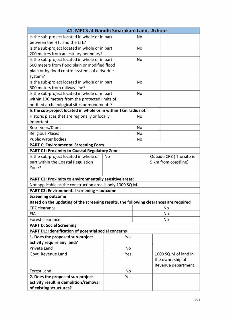
359
41. MPCS at Gandhi Smarakam Land, Azhoor Is the sub-project located in whole or in part between the HTL and the LTL?
No
Is the sub-project located in whole or in part 200 metres from an estuary boundary?
No
Is the sub-project located in whole or in part 500 meters from flood plain or modified flood plain or by flood control systems of a riverine system?
No
Is the sub-project located in whole or in part 500 meters from railway line?
No
Is the sub-project located in whole or in part within 100 meters from the protected limits of notified archaeological sites or monuments?
No
Is the sub-project located in whole or in within 1km radius of:
Historic places that are regionally or locally important
No
Reservoirs/Dams No
Religious Places No
Public water bodies No
PART C: Environmental Screening Form
PART C1: Proximity to Coastal Regulatory Zone:
Is the sub-project located in whole or part within the Coastal Regulation Zone?
No
Outside CRZ ( The site is 5 km from coastline)
PART C2: Proximity to environmentally sensitive areas:
Not applicable as the construction area is only 1000 SQ.M.
PART C3: Environmental screening – outcome
Screening outcome
Based on the updating of the screening results, the following clearances are required
CRZ clearance No
EIA No
Forest clearance No
PART D: Social Screening
PART D1: Identification of potential social concerns
1. Does the proposed sub-project activity require any land?
Yes
Private Land No
Govt. Revenue Land Yes 1000 SQ.M of land in the ownership of Revenue department.
Forest Land No
2. Does the proposed sub-project activity result in demolition/removal of existing structures?
Yes

360
41. MPCS at Gandhi Smarakam Land, Azhoor Number of public structures/buildings No
Number of common property resources (such as religious/cultural/ drinking water/wells/etc)
No
Number of private structures (located on private or public land)
No
3. Does the proposed Project activity result in loss of crops/trees which is not Government property?
No
4. Does the proposed Project activity result in loss of direct livelihood/ employment?
No
5. Does the proposed activity result in loss of mangrove ecosystem/social forest on which near by Residents/local population are dependent for fuel wood/grazing etc.?
No
6. Does the proposed Project activity affect scheduled tribe/ caste communities?
No
Part D (2): Result/Outcome of Social Screening Exercise
Outcome
Social Impact Assessment is required No
Abbreviated RAP is required No
Full RAP is required No
Details of Screening Exercise
Name Mary Midhula Maxy
Designation Environmental and Social Specialist, State Project Implementation Unit

361
42. MPCS at Azhoor, Thiruvananthapuram Part A: General Information about the sub-project
Sub Project id NCRMP/KER/TVM/CHI/AZHOOR-1
Type of proposed sub-project activity MPCS
Location of the sub project activity
State Kerala
District Trivandrum
Taluk Chirayinkeezh
Village Azhoor
Panchayath/Municipal Corporation
Survey Number Block: 14, Survey number: 439/1
Latitude 8⁰37’54.3”N
Longitude 76⁰49’55.8”E
Size of the sub-project
Cyclone Shelter – approx. built up area 1000 SQ.M
Land requirement for the sub project (in Ha or m2)
Total Requirement
a. Private Land Nil
b. Government Land 1000 SQ.M of land in the ownership of Revenue Department
c. Forest Land Nil
Existing Land use Barren land
Approach roads
Road name Untarred approach roads from Main road
Existing road
Proposed road No Approach roads proposed
Boundary wall requirement No Part B: Ascertaining whether the site is a prohibited site PART B1: List of sites where sub-projects are prohibited
Is the sub-project located in whole or in part of any of the following environmentally sensitive areas:
Remarks if any
Biosphere reserve No
National Park No
Wildlife/Bird sanctuary No
Game reserve No
Tiger reserve/elephant reserve No
Wetland No
Important bird areas No
Coastal area with corals No
Mangrove area No
Estuary with mangroves No
Turtle nesting grounds No
Swamps/mudflats No
Notified sensitive eco zone No

362
42. MPCS at Azhoor, Thiruvananthapuram Is the sub-project located in whole or in part between the HTL and the LTL?
No
Is the sub-project located in whole or in part 200 metres from an estuary boundary?
No
Is the sub-project located in whole or in part 500 meters from flood plain or modified flood plain or by flood control systems of a riverine system?
No
Is the sub-project located in whole or in part 500 meters from railway line?
No
Is the sub-project located in whole or in part within 100 meters from the protected limits of notified archaeological sites or monuments?
No
Is the sub-project located in whole or in within 1km radius of:
Historic places that are regionally or locally important
No
Reservoirs/Dams No
Religious Places No
Public water bodies No
PART C: Environmental Screening Form
PART C1: Proximity to Coastal Regulatory Zone:
Is the sub-project located in whole or part within the Coastal Regulation Zone?
No
Outside CRZ (the site is 3km from coastline)
PART C2: Proximity to environmentally sensitive areas:
Not applicable as the construction area is less than 500 SQ.M.
PART C3: Environmental screening – outcome
Screening outcome
Based on the updating of the screening results, the following clearances are required
CRZ clearance No
EIA No
Forest clearance No
Social Forestry Yes [Clearance required from Social Forestry Department for cutting trees, The Kerala Preservation of Trees act, 1986]
PART D: Social Screening
PART D1: Identification of potential social concerns
1. Does the proposed sub-project activity require any land?
Yes
Private Land No
Government Land 600 SQ.M of land in ownership of Revenue
Department
Forest Land No

363
42. MPCS at Azhoor, Thiruvananthapuram 2. Does the proposed sub-project activity result in demolition/removal of existing structures?
Number of public structures/buildings
1 (0ne) [(Anti disaster shelter constructed under
European economic Community project)
Number of common property resources (such as religious/cultural/ drinking water/wells/etc)
No
Number of private structures (located on private or public land)
No
3. Does the proposed Project activity result in loss of crops/trees which is not Government property?
No
4. Does the proposed Project activity result in loss of direct livelihood/ employment?
No
5. Does the proposed activity result in loss of mangrove ecosystem/social forest on which near by residents/local population are dependent for fuel wood/grazing etc.?
No
6. Does the proposed Project activity affect scheduled tribe/ caste communities?
No
Part D (2): Result/Outcome of Social Screening Exercise
Outcome
Social Impact Assessment is required No
Abbreviated RAP is required No
Full RAP is required No
Details of Screening Exercise
Name Mary Midhula Maxy
Designation Environmental and Social Specialist, State Project Implementation Unit
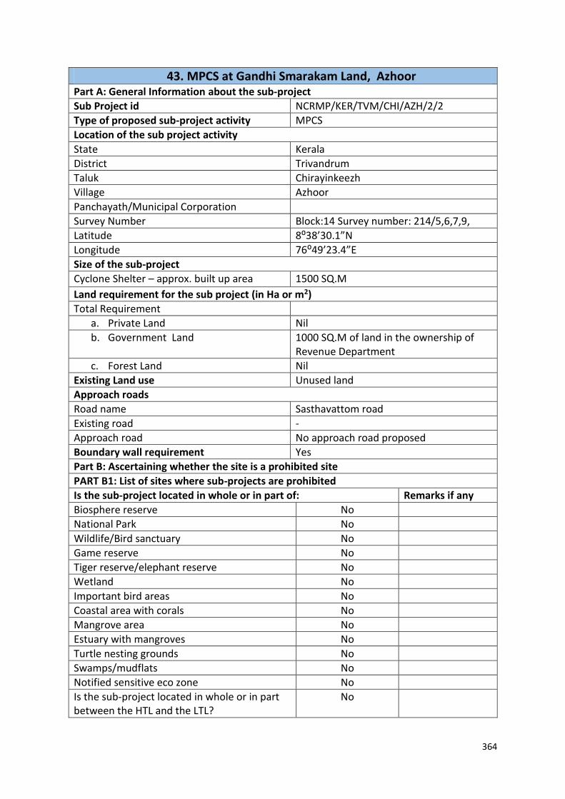
364
43. MPCS at Gandhi Smarakam Land, Azhoor Part A: General Information about the sub-project
Sub Project id NCRMP/KER/TVM/CHI/AZH/2/2
Type of proposed sub-project activity MPCS
Location of the sub project activity
State Kerala
District Trivandrum
Taluk Chirayinkeezh
Village Azhoor
Panchayath/Municipal Corporation
Survey Number Block:14 Survey number: 214/5,6,7,9,
Latitude 8⁰38’30.1”N
Longitude 76⁰49’23.4”E
Size of the sub-project
Cyclone Shelter – approx. built up area 1500 SQ.M
Land requirement for the sub project (in Ha or m2)
Total Requirement
a. Private Land Nil
b. Government Land 1000 SQ.M of land in the ownership of Revenue Department
c. Forest Land Nil
Existing Land use Unused land
Approach roads
Road name Sasthavattom road
Existing road -
Approach road No approach road proposed
Boundary wall requirement Yes
Part B: Ascertaining whether the site is a prohibited site
PART B1: List of sites where sub-projects are prohibited
Is the sub-project located in whole or in part of: Remarks if any
Biosphere reserve No
National Park No
Wildlife/Bird sanctuary No
Game reserve No
Tiger reserve/elephant reserve No
Wetland No
Important bird areas No
Coastal area with corals No
Mangrove area No
Estuary with mangroves No
Turtle nesting grounds No
Swamps/mudflats No
Notified sensitive eco zone No
Is the sub-project located in whole or in part between the HTL and the LTL?
No

365
43. MPCS at Gandhi Smarakam Land, Azhoor Is the sub-project located in whole or in part 200 metres from an estuary boundary?
No
Is the sub-project located in whole or in part 500 meters from flood plain or modified flood plain or by flood control systems of a riverine system?
No
Is the sub-project located in whole or in part 500 meters from railway line?
No
Is the sub-project located in whole or in part within 100 meters from the protected limits of notified archaeological sites or monuments?
No
Is the sub-project located in whole or in within 1km radius of:
Historic places that are regionally or locally important
No
Reservoirs/Dams No
Religious Places No
Public water bodies No
PART C: Environmental Screening Form
PART C1: Proximity to Coastal Regulatory Zone:
Is the sub-project located in whole or part within the Coastal Regulation Zone?
No
Outside CRZ ( The site is 5 km from coastline)
PART C2: Proximity to environmentally sensitive areas:
Not applicable as the construction area is only 1000 SQ.M.
PART C3: Environmental screening – outcome
Screening outcome
Based on the updating of the screening results, the following clearances are required
CRZ clearance No
EIA No
Forest clearance No
PART D: Social Screening
PART D1: Identification of potential social concerns
1. Does the proposed sub-project activity require any land?
Yes
Private Land No
Govt. Revenue Land Yes 1000 SQ.M of land in the ownership of Revenue department.
Forest Land No
2. Does the proposed sub-project activity result in demolition/removal of existing structures?
Yes
Number of public structures/buildings No

366
43. MPCS at Gandhi Smarakam Land, Azhoor Number of common property resources (such as religious/cultural/ drinking water/wells/etc)
No
Number of private structures (located on private or public land)
No
3. Does the proposed Project activity result in loss of crops/trees which is not Government property?
No
4. Does the proposed Project activity result in loss of direct livelihood/ employment?
No
5. Does the proposed activity result in loss of mangrove ecosystem/social forest on which near by Residents/local population are dependent for fuel wood/grazing etc.?
No
6. Does the proposed Project activity affect scheduled tribe/ caste communities?
No
Part D (2): Result/Outcome of Social Screening Exercise
Outcome
Social Impact Assessment is required No
Abbreviated RAP is required No
Full RAP is required No

367
44. MPCS at Muttathara, Survey School land Part A: General Information about the sub-project Sub Project id NCRMP/KER/TVM/THI/MUTTATHARA-2
Type of proposed sub-project activity MPCS
Location of the sub project activity
State Kerala
District Trivandrum
Taluk Thiruvananthapuram
Village Muttathara
Panchayath/Municipal Corporation Trivandrum Corporation
Survey Number Not available
Latitude 8⁰ 27’ 56.4”N
Longitude 76⁰ 55’ 49.9”E
Size of the sub-project
Cyclone Shelter – approx. built up area 1000 SQ.M
Land requirement for the sub project (in Ha or m2)
Total Requirement
a. Private Land Nil
b. Government Land 600 SQ.M of land in the ownership of Revenue Department
c. Forest Land Nil
Existing Land use Barren land
Approach roads
Road name Valiyathura-Sewage farm road
Existing road
Proposed road No approach roads proposed
Boundary wall requirement No
Part B: Ascertaining whether the site is a prohibited site
PART B1: List of sites where sub-projects are prohibited
Is the sub-project located in whole or in part of any of the following environmentally sensitive areas:
Remarks if any
Biosphere reserve No
National Park No
Wildlife/Bird sanctuary No
Game reserve No
Tiger reserve/elephant reserve No
Wetland Yes The site is designated wetland area
Important bird areas No
Coastal area with corals No
Mangrove area No
Estuary with mangroves No
Turtle nesting grounds No
Swamps/mudflats No
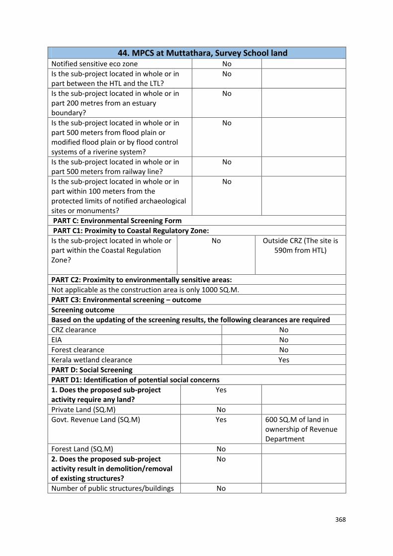
368
44. MPCS at Muttathara, Survey School land Notified sensitive eco zone No
Is the sub-project located in whole or in part between the HTL and the LTL?
No
Is the sub-project located in whole or in part 200 metres from an estuary boundary?
No
Is the sub-project located in whole or in part 500 meters from flood plain or modified flood plain or by flood control systems of a riverine system?
No
Is the sub-project located in whole or in part 500 meters from railway line?
No
Is the sub-project located in whole or in part within 100 meters from the protected limits of notified archaeological sites or monuments?
No
PART C: Environmental Screening Form
PART C1: Proximity to Coastal Regulatory Zone:
Is the sub-project located in whole or part within the Coastal Regulation Zone?
No
Outside CRZ (The site is 590m from HTL)
PART C2: Proximity to environmentally sensitive areas:
Not applicable as the construction area is only 1000 SQ.M.
PART C3: Environmental screening – outcome
Screening outcome
Based on the updating of the screening results, the following clearances are required
CRZ clearance No
EIA No
Forest clearance No
Kerala wetland clearance Yes
PART D: Social Screening
PART D1: Identification of potential social concerns
1. Does the proposed sub-project activity require any land?
Yes
Private Land (SQ.M) No
Govt. Revenue Land (SQ.M) Yes 600 SQ.M of land in ownership of Revenue Department
Forest Land (SQ.M) No
2. Does the proposed sub-project activity result in demolition/removal of existing structures?
No
Number of public structures/buildings No

369
44. MPCS at Muttathara, Survey School land Number of common property resources (such as religious/cultural/ drinking water/wells/etc)
No
Number of private structures (located on private or public land)
No
3. Does the proposed Project activity result in loss of crops/trees which is not Government property?
No
4. Does the proposed Project activity result in loss of direct livelihood/ employment?
No
5. Does the proposed activity result in loss of mangrove ecosystem/social forest on which near by residents/local population are dependent for fuel wood/grazing etc.?
No
6. Does the proposed Project activity affect scheduled tribe/ caste communities?
No
Part D (2): Result/Outcome of Social Screening Exercise
Outcome
Social Impact Assessment is required No
Abbreviated RAP is required No
Full RAP is required No
Details of Screening Exercise
Name Mary Midhula Maxy
Designation Environmental and Social Specialist, State Project Implementation Unit

370
45. MPCS at Tsunami Colony, Chirayinkeezh Part A: General Information about the sub-project Sub Project id NCRMP/KER/TVM/CHI/CHIRAYINKEEZH 2
Type of proposed sub-project activity MPCS
Location of the sub project activity
State Kerala
District Trivandrum
Taluk Chirayinkeezh
Village Chirayinkeezh-Sarkara
Panchayath/Municipal Corporation Chirayinkeezh Panchayath
Survey Number Block: 12, Survey no: 725/7 and 10
Latitude 8⁰38’38.65”N
Longitude 76⁰46’58.52”E
Size of the sub-project
Cyclone Shelter – approx. built up area Site not suitable for construction
Land requirement for the sub project (in Ha or m2)
Total Requirement
a. Private Land Nil
b. Government Land No area available for construction
c. Forest Land Nil
Existing Land use Tsunami shelter exists in the site
Approach roads
Road name Tsunami colony road
Existing road -
Proposed road No approach roads proposed
Boundary wall requirement No
Part B: Ascertaining whether the site is a prohibited site
PART B1: List of sites where sub-projects are prohibited
Is the sub-project located in whole or in part of any of the following environmentally sensitive areas:
Remarks if any
Biosphere reserve No
National Park No
Wildlife/Bird sanctuary No
Game reserve No
Tiger reserve/elephant reserve No
Wetland No
Important bird areas No
Coastal area with corals No
Mangrove area No
Estuary with mangroves No
Turtle nesting grounds No
Swamps/mudflats No
Notified sensitive eco zone No
Is the sub-project located in whole or in part between the HTL and the LTL?
Yes Site is within 50m setback area of

371
45. MPCS at Tsunami Colony, Chirayinkeezh backwaters and is in
CRZ III category
Is the sub-project located in whole or in part200 metres from an estuary boundary?
No
Is the sub-project located in whole or in part500 meters from flood plain or modified flood plain or by flood control systems of a riverine system?
No
Is the sub-project located in whole or in part500 meters from railway line?
No
Is the sub-project located in whole or in part within 100 meters from the protected limits of notified archaeological sites or monuments?
No
PART C: Environmental Screening Form
PART C1: Proximity to Coastal Regulatory Zone:
Is the sub-project located in whole or part within the Coastal Regulation Zone?
Yes
Site is within 50m setback area of
backwaters and is in CRZ III category
PART C2: Proximity to environmentally sensitive areas:
Not applicable as the site is not suitable for construction
PART C3: Environmental screening – outcome
Screening outcome
Based on the updating of the screening results, the following clearances are required
CRZ clearance No
EIA No
Forest clearance No
PART D: Social Screening
PART D1: Identification of potential social concerns
1. Does the proposed sub-project activity require any land?
Yes
Private Land (SQ.M) No
Govt. Revenue Land (SQ.M) - Site is not suitable for construction
Forest Land (SQ.M) No
2. Does the proposed sub-project activity result in demolition/removal of existing structures?
No
Number of public structures/buildings No
Number of common property resources (such as religious/cultural/ drinking water/wells/etc)
No A Tsunami shlter exists in close proximity to
the site
Number of private structures No

372
45. MPCS at Tsunami Colony, Chirayinkeezh (located on private or public land)
3. Does the proposed Project activity result in loss of crops/trees which is not Government property?
No
4. Does the proposed Project activity result in loss of direct livelihood/ employment?
No
5. Does the proposed activity result in loss of mangrove ecosystem/social forest on which near by residents/local population are dependent for fuel wood/grazing etc.?
No
6. Does the proposed Project activity affect scheduled tribe/ caste communities?
No
Part D (2): Result/Outcome of Social Screening Exercise
Outcome
Social Impact Assessment is required No
Abbreviated RAP is required No
Full RAP is required No
Details of Screening Exercise
Name Mary Midhula Maxy
Designation Environmental and Social Specialist, State Project Implementation Unit
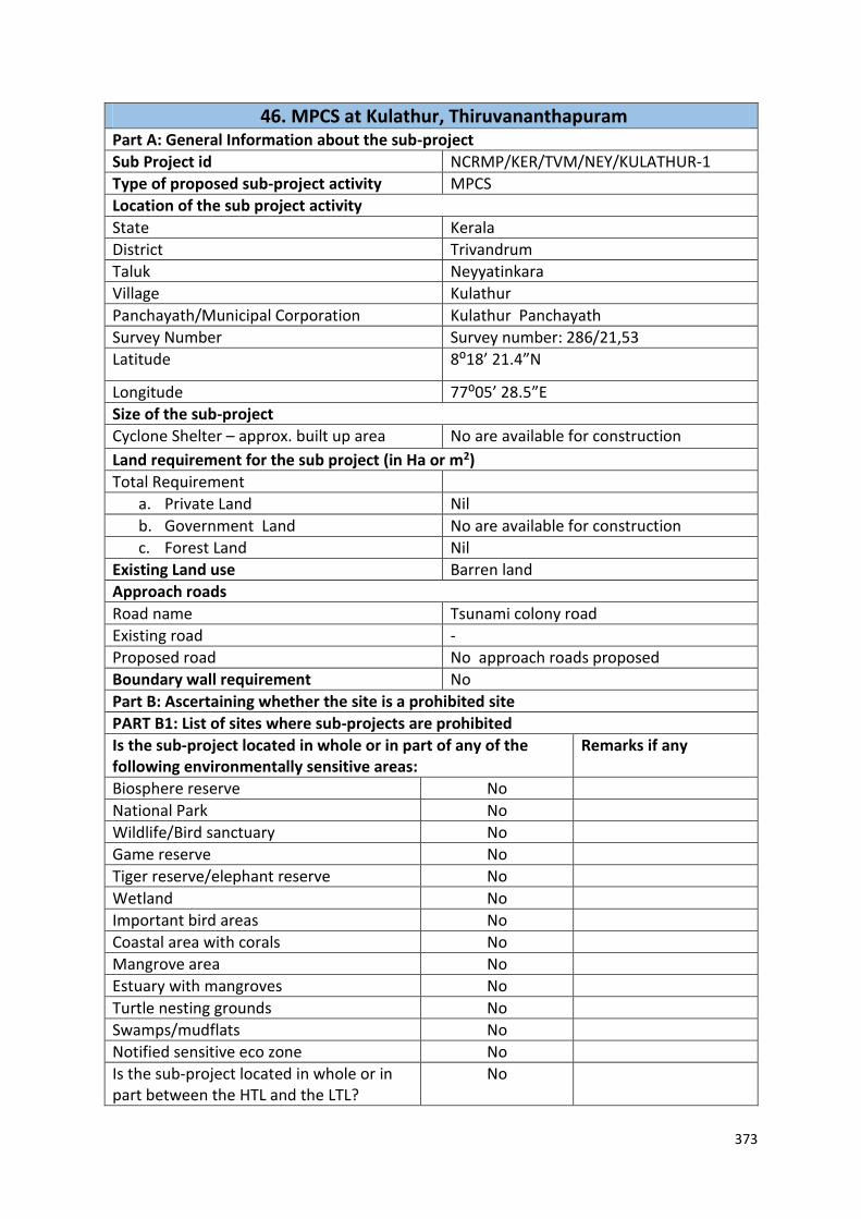
373
46. MPCS at Kulathur, Thiruvananthapuram Part A: General Information about the sub-project
Sub Project id NCRMP/KER/TVM/NEY/KULATHUR-1
Type of proposed sub-project activity MPCS
Location of the sub project activity
State Kerala
District Trivandrum
Taluk Neyyatinkara
Village Kulathur
Panchayath/Municipal Corporation Kulathur Panchayath
Survey Number Survey number: 286/21,53
Latitude 8⁰18’ 21.4”N
Longitude 77⁰05’ 28.5”E
Size of the sub-project
Cyclone Shelter – approx. built up area No are available for construction
Land requirement for the sub project (in Ha or m2)
Total Requirement
a. Private Land Nil
b. Government Land No are available for construction
c. Forest Land Nil
Existing Land use Barren land
Approach roads
Road name Tsunami colony road
Existing road -
Proposed road No approach roads proposed
Boundary wall requirement No
Part B: Ascertaining whether the site is a prohibited site
PART B1: List of sites where sub-projects are prohibited
Is the sub-project located in whole or in part of any of the following environmentally sensitive areas:
Remarks if any
Biosphere reserve No
National Park No
Wildlife/Bird sanctuary No
Game reserve No
Tiger reserve/elephant reserve No
Wetland No
Important bird areas No
Coastal area with corals No
Mangrove area No
Estuary with mangroves No
Turtle nesting grounds No
Swamps/mudflats No
Notified sensitive eco zone No
Is the sub-project located in whole or in part between the HTL and the LTL?
No

374
46. MPCS at Kulathur, Thiruvananthapuram Is the sub-project located in whole or in part200 metres from an estuary boundary?
No
Is the sub-project located in whole or in part500 meters from flood plain or modified flood plain or by flood control systems of a riverine system?
No
Is the sub-project located in whole or in part500 meters from railway line?
No
Is the sub-project located in whole or in part within 100 meters from the protected limits of notified archaeological sites or monuments?
No
PART C: Environmental Screening Form
PART C1: Proximity to Coastal Regulatory Zone:
Is the sub-project located in whole or part within the Coastal Regulation Zone?
No
Site is 700m from coastline
PART C2: Proximity to environmentally sensitive areas:
Not applicable as adequate area is not available for construction
PART C3: Environmental screening – outcome
Screening outcome
Based on the updating of the screening results, the following clearances are required
CRZ clearance No
EIA No
Forest clearance No
PART D: Social Screening
PART D1: Identification of potential social concerns
1. Does the proposed sub-project activity require any land?
Yes
Private Land (SQ.M) No
Govt. Revenue Land (SQ.M) - Site is not suitable for construction
Forest Land (SQ.M) No
2. Does the proposed sub-project activity result in demolition/removal of existing structures?
No
Number of public structures/buildings No
Number of common property resources (such as religious/cultural/ drinking water/wells/etc)
No A Tsunami shlter exists in close proximity to
the site
Number of private structures (located on private or public land)
No

375
46. MPCS at Kulathur, Thiruvananthapuram 3. Does the proposed Project activity result in loss of crops/trees which is not Government property?
No
4. Does the proposed Project activity result in loss of direct livelihood/ employment?
No
5. Does the proposed activity result in loss of mangrove ecosystem/social forest on which near by residents/local population are dependent for fuel wood/grazing etc.?
No
6. Does the proposed Project activity affect scheduled tribe/ caste communities?
No
Part D (2): Result/Outcome of Social Screening Exercise
Outcome
Social Impact Assessment is required No
Abbreviated RAP is required No
Full RAP is required No
Details of Screening Exercise
Name Mary Midhula Maxy
Designation Environmental and Social Specialist, State Project Implementation Unit

376
47. MPCS at Harbour premises, Vizhinjam Part A: General Information about the sub-project
Sub Project id NCRMP/KER/TVM/NEY/VIZHINJAM-1
Type of proposed sub-project activity MPCS
Location of the sub project activity
State Kerala
District Trivandrum
Taluk Neyyatinkara
Village Vizhinjam
Panchayath/Municipal Corporation Vizhinjam Panchayath
Survey Number Block: 12, Survey no: 77/12, 77/11
Latitude 8⁰22’45.5”N
Longitude 76⁰59’22.9”E
Size of the sub-project
Cyclone Shelter – approx. built up area 1500 SQ.M
Land requirement for the sub project (in Ha or m2)
Total Requirement
a. Private Land Nil
b. Government Land 900 SQ.M
c. Forest Land Nil
Existing Land use Barren land
Approach roads
Road name Vizhinjam Harbour road
Existing road -
Proposed road No approach roads proposed
Boundary wall requirement No
Part B: Ascertaining whether the site is a prohibited site
PART B1: List of sites where sub-projects are prohibited
Is the sub-project located in whole or in part of any of the following environmentally sensitive areas:
Remarks if any
Biosphere reserve No
National Park No
Wildlife/Bird sanctuary No
Game reserve No
Tiger reserve/elephant reserve No
Wetland No
Important bird areas No
Coastal area with corals No
Mangrove area No
Estuary with mangroves No
Turtle nesting grounds No
Swamps/mudflats No
Notified sensitive eco zone No

377
47. MPCS at Harbour premises, Vizhinjam Is the sub-project located in whole or in part between the HTL and the LTL?
Yes Site is within 200m from HTL and falls in
CRZ II category
Is the sub-project located in whole or in part200 metres from an estuary boundary?
No
Is the sub-project located in whole or in part500 meters from flood plain or modified flood plain or by flood control systems of a riverine system?
No
Is the sub-project located in whole or in part500 meters from railway line?
No
Is the sub-project located in whole or in part within 100 meters from the protected limits of notified archaeological sites or monuments?
No
PART C: Environmental Screening Form
PART C1: Proximity to Coastal Regulatory Zone:
Is the sub-project located in whole or part within the Coastal Regulation Zone?
Yes
Site is within 200m from HTL and falls in CRZ II
category
PART C2: Proximity to environmentally sensitive areas:
Not applicable as construction area is only 900 SQ.M
PART C3: Environmental screening – outcome
Screening outcome
Based on the updating of the screening results, the following clearances are required
CRZ clearance No
EIA No
Forest clearance No
PART D: Social Screening
PART D1: Identification of potential social concerns
1. Does the proposed sub-project activity require any land?
Yes
Private Land (SQ.M) No
Govt. Revenue Land (SQ.M) Yes 900 SQ.M of land in ownership of Harbour Engineering department
Forest Land (SQ.M) No
2. Does the proposed sub-project activity result in demolition/removal of existing structures?
No
Number of public structures/buildings No

378
47. MPCS at Harbour premises, Vizhinjam Number of common property resources (such as religious/cultural/ drinking water/wells/etc)
No Mosque and church exists within 1km
radius from the site.
Number of private structures (located on private or public land)
No
3. Does the proposed Project activity result in loss of crops/trees which is not Government property?
No
4. Does the proposed Project activity result in loss of direct livelihood/ employment?
No
5. Does the proposed activity result in loss of mangrove ecosystem/social forest on which near by residents/local population are dependent for fuel wood/grazing etc.?
No
6. Does the proposed Project activity affect scheduled tribe/ caste communities?
No
Part D (2): Result/Outcome of Social Screening Exercise
Outcome
Social Impact Assessment is required No
Abbreviated RAP is required No
Full RAP is required No
Details of Screening Exercise
Name Mary Midhula Maxy
Designation Environmental and Social Specialist, State Project Implementation Unit

379
48. MPCS at Vizhinjam, Thiruvananthapuram Part A: General Information about the sub-project
Sub Project id NCRMP/KER/TVM/NEY/VIZHINJAM-2
Type of proposed sub-project activity MPCS
Location of the sub project activity
State Kerala
District Trivandrum
Taluk Neyyatinkara
Village Vizhinjam
Panchayath/Municipal Corporation Vizhinjam Panchayath
Survey Number Block: 14, Survey no:169
Latitude 8⁰22’57.66”N
Longitude 76⁰59’34.20”E
Size of the sub-project
Cyclone Shelter – approx. built up area Area not available for construction
Land requirement for the sub project (in Ha or m2)
Total Requirement
a. Private Land Nil
b. Government Land Area not available for construction
c. Forest Land Nil
Existing Land use Training centres functions in the site
Approach roads
Road name Coastal Police Station road
Existing road -
Proposed road No approach roads proposed
Boundary wall requirement No
Part B: Ascertaining whether the site is a prohibited site
PART B1: List of sites where sub-projects are prohibited
Is the sub-project located in whole or in part of any of the following environmentally sensitive areas:
Remarks if any
Biosphere reserve No
National Park No
Wildlife/Bird sanctuary No
Game reserve No
Tiger reserve/elephant reserve No
Wetland No
Important bird areas No
Coastal area with corals No
Mangrove area No
Estuary with mangroves No
Turtle nesting grounds No
Swamps/mudflats No
Notified sensitive eco zone No
Is the sub-project located in whole or in part between the HTL and the LTL?
No
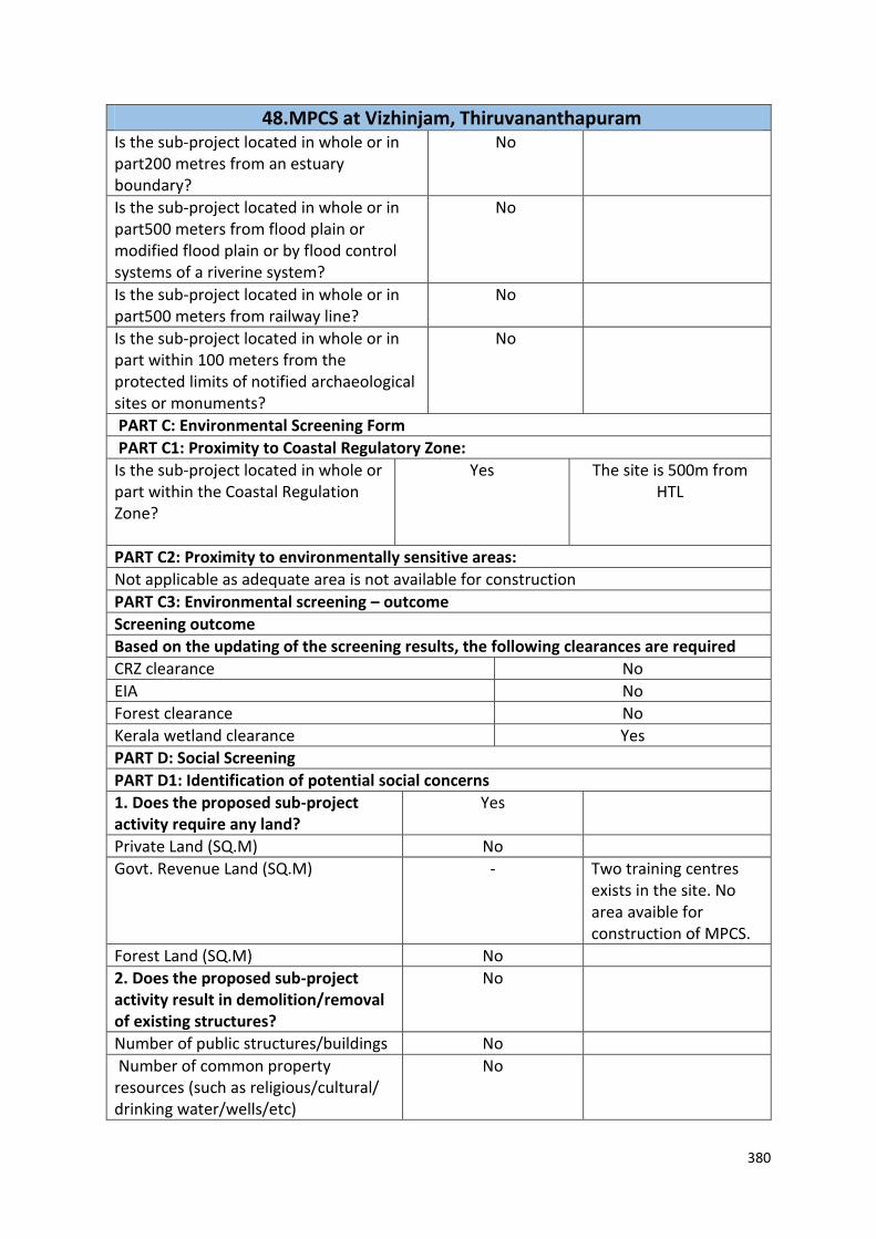
380
48. MPCS at Vizhinjam, Thiruvananthapuram Is the sub-project located in whole or in part200 metres from an estuary boundary?
No
Is the sub-project located in whole or in part500 meters from flood plain or modified flood plain or by flood control systems of a riverine system?
No
Is the sub-project located in whole or in part500 meters from railway line?
No
Is the sub-project located in whole or in part within 100 meters from the protected limits of notified archaeological sites or monuments?
No
PART C: Environmental Screening Form
PART C1: Proximity to Coastal Regulatory Zone:
Is the sub-project located in whole or part within the Coastal Regulation Zone?
Yes
The site is 500m from HTL
PART C2: Proximity to environmentally sensitive areas:
Not applicable as adequate area is not available for construction
PART C3: Environmental screening – outcome
Screening outcome
Based on the updating of the screening results, the following clearances are required
CRZ clearance No
EIA No
Forest clearance No
Kerala wetland clearance Yes
PART D: Social Screening
PART D1: Identification of potential social concerns
1. Does the proposed sub-project activity require any land?
Yes
Private Land (SQ.M) No
Govt. Revenue Land (SQ.M) - Two training centres exists in the site. No area avaible for construction of MPCS.
Forest Land (SQ.M) No
2. Does the proposed sub-project activity result in demolition/removal of existing structures?
No
Number of public structures/buildings No
Number of common property resources (such as religious/cultural/ drinking water/wells/etc)
No

381
48. MPCS at Vizhinjam, Thiruvananthapuram Number of private structures (located on private or public land)
No
3. Does the proposed Project activity result in loss of crops/trees which is not Government property?
No
4. Does the proposed Project activity result in loss of direct livelihood/ employment?
No
5. Does the proposed activity result in loss of mangrove ecosystem/social forest on which near by residents/local population are dependent for fuel wood/grazing etc.?
No
6. Does the proposed Project activity affect scheduled tribe/ caste communities?
No
Part D (2): Result/Outcome of Social Screening Exercise
Outcome
Social Impact Assessment is required No
Abbreviated RAP is required No
Full RAP is required No
Details of Screening Exercise
Name Mary Midhula Maxy
Designation Environmental and Social Specialist, State Project Implementation Unit

382
12. Format for entering update/revision
Sl
no
Date of entry of
update/revision
Category
update/revision
(Design/Legal/
Environment/S
ocial/Other)
Detailed description
of update/revision
Date of
effectiveness of
update/revision
Authorised
signatory