Embed Size (px)
Citation preview

1
National Park Service U.S. Department of the Interior Natural Resource Stewardship and Science
Appalachian National Scenic Trail Geologic Resources Inventory Scoping Summary Prepared by Rebecca Port, December 22, 2016
The Geologic Resources Inventory (GRI) is one of 12 natural resource inventories within the National Park Service (NPS). The Geologic Resources Division (GRD) of the NPS administers the inventory. The GRI provides each of the 270 identified natural area National Park System units with, first, a geologic scoping meeting and summary (this document), followed by a digital geologic map, and lastly a GRI report. The purpose of a GRI scoping meeting is to 1) evaluate the adequacy of existing geologic maps for resource management purposes, 2) discuss distinctive geologic features and processes, and 3) identify potential geologic management issues. The NPS GRI scoping meeting for Appalachian National Scenic Trail was divided into three meetings, each held at a different location to facilitate attendance by participants spread over the wide geographical area covered by the trail. A site visit was not part of the scoping process. The first meeting was held on 2 May 2016 in Gatlinburg, Tennessee; the second meeting was held on 4 May 2016 at the National Conservation Training Center in Shepherdstown, West Virginia; the final meeting was held on 6 May 2016 at the University of Massachusetts in Amherst, Massachusetts. Participants included NPS staff from GRD, Appalachian National Scenic Trail, Great Smoky Mountains National Park, and Inventory and Monitoring Networks; GRI team members from Colorado State University; cooperators from state geological surveys and the US Geological Survey (USGS); staff from the USDA Forest Service and the Natural Resources Conservation Service; and faculty from the University of Massachusetts (table 1). Each meeting began with an overview of the GRI program (Bruce Heise, National Park Service, GRI program coordinator) and an explanation of the GRI digital map products (Jim Chappell or Georgia Hybels, Colorado State University, GIS specialists). Meeting participants then had an opportunity to present the geologic maps available in their respective state/region. The remainder of the meeting involved a group discussion of map coverage and needs, geologic features and processes, and potential geologic resource management issues along the trail. During the scoping meeting on 4 May 2016, Appalachian National Scenic Trail superintendent, Wendy Jansen, provided general information about the trail, including a brief history and description of resource management issues she and her staff are currently facing. The Appalachian National Scenic Trail’s GIS specialist, Matt Robinson, also gave a presentation on 4 May 2016. He explained the dynamic nature of the Appalachian Trail boundary and how this affects resource management and trail maintenance. This scoping summary highlights discussions that occurred during the GRI scoping meetings for the Appalachian National Scenic Trail and includes the following sections: • Park Introduction • Geologic Setting • Status of Geologic Maps • Geologic Features, Processes, and Issues • Literature Cited

2
Table 1. Scoping meeting participants
Name Affiliation Position
Brian Carlstrom NPS Natural Resources Stewardship and Science (NRSS) Deputy Associate Director
Tim Connors NPS NRSS Geologic Resources Division Geologist Bruce Heise NPS NRSS Geologic Resources Division Geologist Rebecca Port NPS NRSS Geologic Resources Division Geologist Hal Pranger NPS NRSS Geologic Resources Division Chief, Geologic Features and Systems Branch
Vincent L. Santucci NPS NRSS Geologic Resources Division Senior Paleontologist/GRD Liaison Jim Chappell Colorado State University Geologist GIS Specialist
Georgia Hybels Colorado State University GIS Specialist Wendy Janssen NPS Appalachian National Scenic Trail Superintendent Matt Robinson NPS Appalachian National Scenic Trail GIS Specialist Jim Von Haden NPS Appalachian National Scenic Trail Integrated Resources Manager Brian Witcher NPS Appalachian Highlands Network Program Manager Tom Remaley NPS Great Smoky Mountains National Park Inventory and Monitoring Coordinator
Fred Dieffenbach NPS Northeast Temperate Network Environmental Monitoring Coordinator
John Brock US Geological Survey Program Coordinator, National Cooperative Geologic Mapping Program
Jack Epstein US Geological Survey Emeritus Geologist
Randall Orndorff US Geological Survey Director, Eastern Geology and Paleoclimate Center
Melissa Reichert USDA Forest Service Recreation Program Manager
Susan Southard USDA Natural Resources Conservation Service Soil Scientist
Bart Cattanach North Carolina Geological Survey Geologist Kenneth B. Taylor North Carolina Geological Survey State Geologist
Pete Lemiszki Tennessee Geological Survey Chief Geologist
Matt Heller Virginia Division of Geology and Mineral Resources Geologist Supervisor
Michael Hohn West Virginia Geological Survey Director David K. Brezinski Maryland Geological Survey Geologist
Rebecca Kavage Adams Maryland Geological Survey Geologist Richard Ortt Maryland Geological Survey Director
Gale Blackmer Pennsylvania Geological Survey State Geologist Gary M Fleeger Pennsylvania Geological Survey Geologist Supervisor
Bill Kelly New York State Geological Survey State Geologist (retired) James Bogart Connecticut Geological Survey Intern
Margaret Thomas Connecticut Geological Survey State Geologist Joe Kopera Massachusetts Geological Survey Geologist
Steve Mabee Massachusetts Geological Survey State Geologist Don Wise University of Massachusetts Retired Geology Faculty
Marjorie Gale Vermont Geological Survey State Geologist Rick Chormann New Hampshire Geological Survey State Geologist
Henry Berry Maine Geological Survey Bedrock Geologist
Note: Contact information is retained by the Geologic Resources Division.

3
Park Introduction In 1921, Benton MacKaye—considered the founder of the Appalachian Trail—drafted the original plan for a greenway connecting local communities and wildlands running the length of the Appalachian Mountains. Under the coordination of the Appalachian Trail Conservancy (ATC), volunteer hiking clubs designed and constructed such a trail and by 1937 the Appalachian Trail was opened as a continuous trail from Georgia to Maine. In 1968, the National Trails System Act designated the Appalachian Trail as the first National Scenic Trail. The Appalachian National Scenic Trail is roughly 2,180 miles long and passes through 14 states—Georgia, North Carolina, Tennessee, Virginia, West Virginia, Maryland, Pennsylvania, New Jersey, New York, Connecticut, Massachusetts, Vermont, New Hampshire, and Maine. It is the longest continuously marked footpath in the world; iconic white blazes adorn the trail (fig. 1). The southern terminus of the trail is Springer Mountain in Georgia and the northern terminus is Mount Katahdin in Maine. Virginia has the most trail miles (about 550 miles), while West Virginia contains the least (about 4 miles). Several million visitors hike at least a portion of the trail each year. A “thru-hiker” walks the entire trail continuously. Thousands attempt to thru-hike the trail each year; an average of one in four completes the journey. Most start in the south in the spring and end in fall (taking an average of 6 months).
Figure 1. White blazes mark the location of the Appalachian National Scenic Trail, Max Patch, North Carolina. NPS photograph by Matt Robinson.
The National Park Service has overall responsibility for the Appalachian National Scenic Trail; however, management is highly collaborative and depends substantially on volunteers due to the incredible length of the trail and number of private, federal, and state lands it intersects. The Appalachian Trail has more federal boundary (more than 1,200 miles of exterior federal boundary) than any other park except for Wrangell-St. Elias National Park in Alaska. And this figure does not include the 6 units of the National Park System, 8 national forests, 2 fish and wildlife refuges, and more than 70 state parks the trail traverses (Appalachian Trail Conservancy 2009). The trail is currently protected along more than 99 percent of its course by federal or state ownership of the land or by right-of-way. The ATC manages day-to-day operations under special agreements with the National Park Service and the Forest Service (Appalachian Trail Conservancy 2009). Annually, more than 6,000 volunteers contribute more than 200,000 hours on the Appalachian Trail, the second largest volunteer program in the NPS. The Appalachian National Scenic Trail is unique among units of the National Park System because its legislative boundary is not fixed; the NPS has the authority to attempt to purchase land in order to reroute sections of the trail. Rerouting may be desired due to trail degradation—to find a more sustainable route—or in order to afford protection to a particular area and improve visitor

4
experience—to an area that deserves protection (Matt Robinson, Appalachian National Scenic Trail, GIS specialist, scoping meeting comment, 4 May 2016).
Geologic Setting The Appalachian National Scenic Trail is a long-distance trail running along the backbone—the ridge crests and major valleys—of the Appalachian Mountains. The Appalachians are an ancient mountain chain (mountain-building ceased about 240 million years ago) that today are worn down and forested. Their current height is relatively stable; erosion and weathering, which lowers the mountains approximately 1 inch every 600 years, is balanced by uplift (Chew 1988). Though worn down from their former glory, the elevation change along the trail is not insignificant; the net elevation gain along the length of the trail is equivalent to 16 times that of Mount Everest. The geologic story of the Appalachian Mountains is arguably one of the most interesting and relevant in all of the National Park System as it describes the formation of much of eastern North America. The history is long (beginning more than a billion years ago), complex (numerous mountain building episodes), and still not fully understood (research is active and often controversial) which presents both opportunities and challenges for those working to maintain, protect, and interpret the Appalachian National Scenic Trail. Geologic interpretations along the trail may quickly become outdated. Therefore, routine consultation of scientific literature and discussion with local experts is crucial for successful resource management and interpretation. The geologic history of the Appalachian Mountains can be divided as follows: 1) Mesoproterozoic orogenic activity. Continental collisions, metamorphism, and igneous intrusions associated with the Grenville orogeny produced the oldest rocks found along the Appalachian Trail—roughly 1.3 billion year old gneiss and schist. These rocks make up the “basement” of much of northeastern America (Chew 1988). The Appalachian Trail crosses Grenville basement rocks in Vermont, Massachusetts, Connecticut, New York, New Jersey, Virginia, Tennessee, and North Carolina (Chew 1988). It is important to note that these basement rocks occur in places at the surface today only because much later tectonic activity (after the Mesoproterozoic Era) broke up and thrust slivers of Grenville rock westward and on top of younger rocks. Even older rocks, up to 1.8 billion years old, may occur at Roan High Knob and Round Bald on the Tennessee-North Carolina border (Chew 1988). 2) Neoproterozoic rifting. Rifting—pulling apart—split and stretched Earth’s crust, resulting in both sedimentation (in low places on the rift, atop Grenville rocks) and volcanism (along the newly formed continental margin of Laurentia). From Pennsylvania to Virginia lava spilled from volcanoes and flowed in sheets to form the rock basalt (Chew 1988). Ash also erupted and became a rock known as welded tuff (Chew 1988). This activity, roughly 800 million to 600 million years ago, produced the protoliths (parent rock) of the Central and Eastern Blue Ridge terranes and the sediments of the Western Blue Ridge Terrane (Bart Cattanach, North Carolina Geological Survey, geologist, scoping meeting presentation, 2 May 2016). 3) Paleozoic orogenic activity. In the beginning of the Paleozoic Era, prior to Paleozoic orogenic activity, most of the eastern United States was below sea level along a passive tectonic margin. Sandstone (and quartzite) and later limestone (and dolomite) formed in this offshore environment (Chew 1988). Some shale (originally mud) layers occur within the limestone and may display ripple marks (Chew 1988). Some of the limestone was later metamorphosed to marble

5
which is found today in the southern New England Valleys that the trail crosses in New York, Connecticut, and Massachusetts (Chew 1988). Orogenic activity began with continental collisions during the Ordovician Period. This activity metamorphosed the older rocks formed during the rifting of the Neoproterozoic Era, produced new igneous bodies, and created what we think of as the Appalachian Mountains (Bart Cattanach, North Carolina Geological Survey, geologist, scoping meeting presentation, 2 May 2016). Paleozoic orogenic activity consists of several deformational events, of which the timing, number, and extent is not fully understood. For example, there is new evidence in Massachusetts for up to five Paleozoic deformational events, suggesting tectonic activity may be more continuous than previously thought (Steve Mabee, Massachusetts Geological Survey, state geologist, comment on scoping summary draft, 11 October 2016). In general, Paleozoic orogenic activity can be subdivided as follows:
1. Taconic orogeny. During the Ordovician Period, volcanic islands collided with the eastern edge of the limestone that was forming on the continental shelf in a shallow sea. Mud accumulated as the islands shed sediments on top of the limestone, forming shale. The volcanoes and the limestone and mud all became jumbled together. Today the Taconic Range in New England is the remains of this mass. Taconic mountain-building shoved rocks westward, up and over younger rocks, substantially shortening Earth’s crust (probably by several hundred miles) (Chew 1988). During the Silurian Period, the Taconic Mountains eroded. Rivers flowing off the mountains deposited sand, gravel, and mud; iron ore is found in some of these deposits (Chew 1988).
2. Acadian orogeny. In the Late Devonian Epoch, an ancient microcontinent—Avalonia and Baltica landmasses—collided with North America, adding the coastal areas of Maine, Massachusetts, and Rhode Island. The collision raised New England above sea level; volcanoes formed, lava flowed, and plutons developed deep underground (some of which are now exposed due to erosion); and many pre-existing rocks were metamorphosed. Shortly after formation, the Acadian mountains began eroding. The coal and shale found in Virginia (west of the Appalachian Trail) formed at this time when eroded organic material and mud settled into the anoxic deep of the surrounding ocean (Chew 1988). The sediments eroded from these mountains accumulated in layers six to seven vertical miles deep (Chew 1988).
3. Alleghanian orogeny. In the Permian Period, the African continent collided with North America to form the supercontinent Pangea and the modern Appalachian Mountains. The collision metamorphosed the Proterozoic rocks—Grenville basement rocks, sediments, and basalt—and thrust them west and on top of younger rocks creating the Blue Ridge Mountains. To the west of the Blue Ridge, the Valley and Ridge Province formed where the early Paleozoic sedimentary rocks were folded westward and forced over massive thrust faults. In this province characterized by parallel valleys and ridges, erosion resistant sandstone and quartzite form ridges while limestone (a soluble rock) tends to form valleys. The majority of the Appalachian Trail is along the Blue Ridge and Valley and Ridge provinces.
6
In the Mesozoic Era, after the formation of the Appalachian Mountains, Pangea began to separate, breaking apart North America and Africa, and creating the Atlantic Ocean basin between the two continents. Similar to the Neoproterozoic rifting, molten material rose from deep within the Earth to fill the cracks between the separating plates; sediment also accumulated in the spaces (Chew 1988). The Appalachian Mountains began eroding at this time. Erosion has removed an estimated 1 ½ miles of rock since the end of the Cretaceous Period, 66 million years ago (Chew 1988). In the Cenozoic Era, the most significant geologic activity in the Appalachian region was Pleistocene glaciations. Glaciers repeatedly extended south and then retreated over the course of roughly 2 million years. The most recent cycle occurred 20,000 years ago; thousands of feet of ice reached as far south as Pennsylvania and the Ohio River Valley (Chew 1988).
Georgia In Georgia, the Appalachian Trail is entirely within the Chattahoochee National Forest. The trail follows the rises and falls of the eastern ridge of the Blue Ridge Province and summits several of the state’s highest peaks. Views from the trail are of the Blue Ridge and Piedmont Plateau. The trail primarily traverses late Proterozoic gneiss in this state.
North Carolina and Tennessee The majority of the Appalachian Trail in North Carolina and Tennessee runs along the state border (fig. 2). Along this stretch, the trail passes through Great Smoky Mountains National Park where it reaches the summit of Clingmans Dome (6,643 ft), marking the highest point along its journey from Georgia to Maine. Thornberry-Ehrlich (2008) produced a geologic resources inventory report for Great Smoky Mountains National Park. Moore (1988) wrote a roadside guide to the geology of park. These reports may be useful to resource managers and in the production of the geologic resources inventory report for Appalachian National Scenic Trail. The Blue Ridge Parkway runs roughly parallel to and east of the trail in North Carolina; the trail does not cross the parkway in this state. Carter et al. (1999) produced a report of the geology along the Blue Ridge Parkway which may be useful for understanding the geology along the trail nearby and in the production of the geologic resources inventory report for Appalachian National Scenic Trail. Throughout North Carolina, the trail is in the Blue Ridge Province. The Hayesville Fault and Murphy Syncline cross the trail in North Carolina. The trail leaves the border with North Carolina in northeastern Tennessee, leaving the Blue Ridge Province and entering the Valley and Ridge Province.

7
Figure 2. Map of the Appalachian Trail and physiographic provinces in North Carolina. The trail (blue line) runs through the Blue Ridge Province and along the North Carolina-Tennessee border for a considerable distance where it also crosses Great Smoky Mountains National Park. Graphic by Bart Cattanach (North Carolina Geological Survey).
Virginia The Appalachian Trail snakes from the Blue Ridge Mountains out into the valley and back, providing a variety of geology and landscapes for hikers to enjoy. In the south, the trail begins in the Blue Ridge where it summits Mount Rogers and passes briefly through a corner of Grayson Highlands State Park. The trail then crosses into the Valley and Ridge; near Blackhorse Gap the trail returns to the Blue Ridge province. The state of Virginia contains the most Appalachian Trail-miles, the bulk of which are through Jefferson and George Washington National Forests; the trail crosses the Blue Ridge parkway twice while in the national forests. The trail then proceeds through the long axis of Shenandoah National Park, with extraordinary views. Thornberry-Ehrlich (2008) completed the geologic resources inventory report for Shenandoah National Park. The trail continues northeast, passing through G. R. Thompson State Wildlife Management Area and Sky Meadows State Park before exiting the state into Harper’s Ferry, West Virginia.
West Virginia Appalachian National Scenic Trail meanders back and forth across the Virgina-West Virginia border for several miles before it reaches Harper’s Ferry—the confluence of the Shenandoah and Potomac Rivers. The rivers carved a notch in the mountains, providing passage west. The trail crosses both rivers. In 1783, Thomas Jefferson described the view of the Shenandoah and Potomac rivers confluence from a cliff at Harper’s Ferry, which today is along the trail, as a scene “worth a voyage across the Atlantic”. The rock from which Thomas Jefferson made this observation became known as “Jefferson’s Rock.” Around 1860, supports were placed around the rock because the risk of it falling was a threat to people and property below (fig. 3).

8
Figure 3. Photograph of Jefferson’s Rock. Thomas Jefferson described the view of the Shenandoah and Potomac Rivers from this location in 1783. The supports were placed around the rock in 1860 to prevent it from falling. NPS photograph by Rebecca Port.
Maryland The trail overlaps with the Chesapeake & Ohio Canal National Historical Park towpath after crossing the Potomac River from West Virginia into Maryland. As it continues, Appalachian National Scenic Trail follows the ridge crest of South Mountain. South Mountain is the western limb of the South Mountain anticline; it is made up of the Late Precambrian–Cambrian Weverton Formation quartzite (formerly quartz sandstone, metamorphosed during Appalachian mountain-building). Hagerstown Valley (to the west) and Middletown Valley (to the east) are on either side of the South Mountain ridge. In some places the South Mountain limb is overturned (David Brezinski, Maryland Geological Survey, geologist, scoping meeting presentation, 4 May 2016). South of Crampton’s Gap the anticline limb is overturned and the Weverton Formation rocks dip steeply southeast. The overturned limb places Blue Ridge rocks over younger Great Valley rocks. North of Crampton’s Gap the anticline limb is not overturned. In this section, Monument Knob is the “right-side-up” limb of the fold that has been raised by thrust sheets. Where the limb is not overturned the ridge becomes less obvious due to cross-faults. Interstate 70 follows a cross-fault where it crosses the Appalachian Trail south of South Mountain State Park. North of this area the limb becomes overturned again and the ridge becomes more prominent. The ridge is terminated at the Pennsylvania border by the Triassic Antietam Cove Fault.

9
Pennsylvania The mid-point of the Appalachian National Scenic Trail occurs in Pennsylvania. Pennsylvania is probably the state with the most geologic diversity along the trail. It is where the trail crosses from glaciated to unglaciated terrain (Gary Fleeger, Pennsylvania Geological Survey, geologist, scoping meeting presentation, 4 May 2016). The Appalachian Trail in Pennsylvania follows the ridges east of the Allegheny Mountains, crosses Cumberland Valley, and follows the northernmost extension of the Blue Ridge. From south to north the trail passes through the following physiographic regions: (1) South Mountain; (2) Great Valley Section—a broad open valley underlain by intensely folded and faulted bedrock shale and limestone (Wilshusen 1983); (3) Appalachian Mountain Section; and (4) runs along the border of the Great Valley and Appalachian Mountain sections (fig. 4). The trail leaves Pennsylvania at Delaware Water Gap National Recreation Area along Kittatinny Mountain, which is actually a long ridge (see Thornberry-Ehrlich 2013). The ridge is composed of 440 million year old quartzite and conglomerate of the Shawangunk and Tuscarora formations (Wilshusen 1983). Wilshusen (1983) prepared a report on the geology of the Appalachian Trail in Pennsylvania. The report describes geologic features which can be seen from the trail and contains geologic sketches, cross sections, photographs, and a geologic map. A presentation prepared by Gary Fleeger of the Pennsylvania Geological Survey for the GRI scoping meeting is saved on the GRD network drive (available by request). There is a wealth of information in these two resources. The information will not be summarized here because it is beyond the scope of this summary document.
Figure 4. Physiographic map of the extent of Pleistocene glaciation in Pennsylvania. The Appalachian Trail (yellow line) crosses four physiographic sections in Pennsylvania and passes through or near two National Natural Landmarks (red text). The Blue dashed line is the boundary between glaciated and unglaciated terrain. Graphic by Gary Fleeger (Pennsylvania Geological Survey).

10
New Jersey The Appalachian Trail terrain is less wild in New Jersey than other states. The most rugged area in New Jersey is around Kittatinny Mountain. The Appalachian Trail passes from the Valley and Ridge to the New England Province in New Jersey (Gary Fleeger, Pennsylvania Geological Survey, geologist, email communication, 12 October 2016)
New York The Appalachian Trail crosses the Hudson River in New York at the Bear Mountain Bridge. The trail passes through Bear Mountain State Park and Harriman State Park. The New York landscape around the trail consists of rolling hills with dense suburban development. Rocks are primarily Precambrian marble and granite, gneiss, and some leucogranite; very few Taconic rocks occur in New York because Appalachian deformation removed them (Bill Kelly, New York Geological Survey, state geologist, scoping meeting presentation, 6 May 2016).
Connecticut The Appalachian Trail in Connecticut goes through the western highlands—worn down remnants of a much loftier mountain range. Here, the deep Housatonic Valley is underlain by marble (metamorphosed early Paleozoic carbonate shelf sediments) and bordered by steep-sided, high plateaus of Proterozoic schist and gneiss of the Taconic and Berkshire ranges. More detailed geologic information was presented by James Bogart (Connecticut Geological Survey) at the scoping meeting on 6 May 2016. This presentation is saved on the GRD network drive (available by request) and should be consulted during the GRI report writing phase. The information will not be summarized here because it is beyond the scope of this summary document. Approximately 30 years ago, a section of the trail in Connecticut was rerouted. The old route, though no longer officially part of the trail, is still used by hikers, has some geologic points of interest, and may have cultural significance (James Bogart, Connecticut Geological Survey, intern, scoping meeting presentation, 6 May 2016).
Massachusetts The Appalachian Trail traverses the Berkshire Hills in Massachusetts. The Berkshires consist of wooded areas and valleys; the shape of the landscape is largely controlled by Taconic-age thrust sheets and carbonate valleys underlain by the Stockbridge Marble (Joe Kopera, Massachusetts Geological Survey, geologist, scoping meeting presentation, 6 May 2016). Taconic orogenic activity thrust allocthonous—originating elsewhere—metamorphic rocks (e.g., gneiss) up and over younger, autochthonous—originating locally—marble (former shelf sediments). The trail also crosses an area of igneous intrusive rocks. High points along the trail include Mount Greylock (3491 ft [1064 m]) and Mount Everett (2602 ft [793 m]). Geologic points of interest along the trail include a food-grade marble quarry situated within a small syncline which produces calcium for antacid medication and paper coating. Also, vegetation changes along the trail can be linked to changes in rock type. For example, spring assemblages which include plants like ramps and jack-in-the-pulpits only occur in carbonate valleys (Joe Kopera, Massachusetts Geological Survey, geologist, scoping meeting presentation, 6 May 2016). Field trip guide books by the New England Intercollegiate Geological Conference will be a good resource during preparation of the final GRI report. However, there are potentially a lot of sites

11
along the Appalachian Trail where one can see fascinating geology, not all of which are listed in the guides (Joe Kopera, Massachusetts Geological Survey, geologist, scoping meeting presentation, 6 May 2016).
Vermont Appalachian National Scenic Trail runs north from Massachusetts through Green Mountain National Forest to Killington, Vermont along the west limb of the Green Mountain Anticlinorium. The Green Mountains are a high, rugged country of abandoned and overgrown farmlands and woods. After Killington, the trail turns east toward New Hampshire. Through its course in Vermont, the Appalachian Trail crosses Proterozoic- through Devonian-age rocks. Between mountain-building events (when little crustal movement was occurring) the Appalachian Mountains eroded substantially and a relatively flat surface called a peneplain formed. Several peneplains are visible in the Appalachians, each correlated to a different episode of erosion and lack of tectonic activity. This peneplain layering is probably best illustrated in Vermont (Don Wise, University of Massachusetts, retired geology faculty, scoping meeting comment, 6 May 2016). The high points along the trail—Stratton Mountain, Prospect Peak, Spruce Peak, Bromley Mountain, Styles Peak, Peru Peak—are monadnocks (survivors of erosion) of the oldest peneplain. Marjorie Gale (Vermont Geological Survey) presented more detailed geologic information at the scoping meeting on 6 May 2016. Her presentation is saved on the GRD network drive (available by request) and should be consulted during preparation of the GRI report.
New Hampshire Some of the youngest rocks at the surface along the trail occur in New Hampshire; they are primarily Jurassic-age granite (Chew 1988). In New Hampshire, the Appalachian Trail crosses deep notches (e.g., Franconia Notch) which are surrounded by high mountains (e.g., the Presidential Range). Parts of the trail in the White Mountains are at elevations above tree line (the altitude above which timber ceases to grow). Logging is a big part of the cultural story on this part of the Appalachian Trail; in many places the trail follows old railroad beds that were built by lumber companies (Rick Chormann, New Hampshire Geological Survey, state geologist, scoping meeting presentation, 6 May 2016).
Maine The northern terminus of the Appalachian Trail is in Maine on Mount Katahdin in Baxter State Park. The longest wilderness section of the trail is in Maine—100 miles (161 km). On 24 August 2016, Katahdin Woods and Waters National Monument was established by presidential proclamation. It borders Baxter State Park to the east; the trail does not enter the monument. Maine is known for its world-class pegmatite minerals; watermelon tourmaline—green tourmaline with a red center—is popular among collectors. A gem and mineral museum is planned to open near the trail. Illegal mineral collection may be occurring along the trail in Maine. This section of the trail is monitored closely because it is where most thru-hikers end their journey and there have been issues with trash and celebratory activity. Illegal mineral collection may be more difficult due to the heightened surveillance in this area (Fred Dieffenbach, NPS Northeast Temperate Network, environmental monitoring coordinator, scoping meeting and email comment, 6 May 2016 and 12 September 2016).

12
Status of Geologic Maps GRI’s digital geologic maps reproduce all aspects of paper maps, including notes, legend, and cross sections, with the added benefit of being GIS compatible. The NPS GRI Geology-GIS Geodatabase Data Model incorporates the standards of digital map creation for the GRI and allows for rigorous quality control. Staff members digitize maps or convert digital data to the GRI digital geologic map model using ESRI ArcGIS software. Final digital geologic map products include data in geodatabase and shapefile format, layer files complete with feature symbology, Federal Geographic Data Committee (FGDC)–compliant metadata, a PDF help file that captures ancillary map data, and a document that displays the map. Final data products are posted at https://irma.nps.gov/Portal. The data model is available at http://science.nature.nps.gov/im/inventory/geology/GeologyGISDataModel.cfm. When possible, the GRI provides large scale (1:24,000) digital geologic map coverage for each National Park System unit’s area of interest, which is often composed of the 7.5-minute quadrangles that contain parklands. Maps at a scale of 1:24,000 (and larger) are useful for resource management because they capture most geologic features of interest and are spatially (horizontally) accurate to within 12 m (40 ft). Geologic map coverage for the area of interest of Appalachian National Scenic Trail is not complete. The following subsections discuss the completeness of geologic map coverage by state. Existing maps are listed in the tables below and are also viewable on a web map at http://nps.maps.arcgis.com/home/webmap/viewer.html?webmap=b60414ea949f43638110fe6a9b52b650. Geologic map coverage discussions focused on bedrock geology, however, scoping meeting participants communicated the need for both bedrock and surficial (including glacial) maps of Appalachian National Scenic Trail. At a minimum, the GRI team will compile a bedrock geologic map. Surficial map coverage is less complete and has more variable nomenclature than bedrock maps, making it more of a challenge to produce a compiled map for the entire trail. The state by state discussions below are focused on bedrock map coverage. Surficial map coverage will not be assessed in this document but should be revisited. At this time, Jim Chappell has fairly decent documentation of surficial maps for the southern half of the trail. Additionally, meeting participants expressed a willingness to assist with surficial map discovery and compilation.
Georgia At the scoping meeting, Kenneth Taylor (North Carolina Geological Survey) offered to compile a list of professors and students that have done mapping along the Appalachian Trail in Georgia and to provide an opinion about the maps’ accuracy. Substantial mapping may have already been completed by graduate students.

13
Table 2. Map coverage for Appalachian National Scenic Trail in Georgia
Year Title Author Organization Series Scale Format GRI Action
1983
Geologic Map of the Blood Mountain Roadless Area, Union and Lumpkin Counties Nelson USGS
MF-1503-A 1:30000 paper
b/w map; digitize and combine with other roadless area maps
1983
Geologic Map of the Cattahoochee Roadless Area, Towns, Union, and White Counties Nelson USGS
MF-1502-A 1:30000 paper
b/w map; digitize and combine with other roadless area maps
1982 Geologic Map of the Tray Mountain Roadless Area Nelson USGS
MF-1347-A 1:30000 paper
b/w map; digitize and combine with other roadless area maps
1913 Ellijay folio, Georgia-North Carolina-Tennessee
La Forge and Phalen USGS GF-187 1:125000 paper
bedrock only; could be better than state dataset; digitize
1991
Geology, geochemistry, and mineral resource assessment of the southern Nantahala Wilderness and adjacent roadless areas
Peper et al. USGS
Bulletin 1883 1:48000 paper
digitize and integrate with adjacent maps
1976 Geologic map of Georgia Lawton et al.
Georgia Department of Natural Resources NA 1:500000 paper
digitize; use to fill in gaps between more detailed maps
North Carolina In addition to the maps listed below, the North Carolina Geological Survey produced a compiled state map at 1:100,000 scale that is now outdated but could be used to fill in any gaps in the GRI GIS data. The state survey completed a detailed hazards map for Blue Ridge Parkway; a similar map would be very useful for the Appalachian Trail. Table 3. Map coverage for Appalachian National Scenic Trail in North Carolina
Year Title Author Organization Series Scale Format GRI Action
1980
Geologic map and mineral resources summary of the Prentiss quadrangle Hatcher
North Carolina Geological Survey
GM 167-SW 1:24000 paper
b/w; digitize and integrate with adjacent maps
2003
Bedrock Geologic Map of the Spring Creek 7.5-Minute Quadrangle
Cattanach et al.
North Carolina Geological Survey GMS - 12 1:24000 paper digitize
1985 Geologic map of North Carolina ?
North Carolina Geological Survey
General Geologic Map 1:500000 paper
digitize; use to fill in gaps between more detailed maps
2012
Geologic Map of Great Smoky Mountains National Park Region
Southworth et al. USGS SIM-2997 1:100000
GRI GIS
In GRI format; derived from and same as USGS SIM-2997
2000 Geology of the Mount Le Conte 7.5-minute quadrangle
Schultz et al. USGS
OF-2000-261 1:24000 paper
Southworth map; probably referenced in SIM-2997; capture if not
2002
Bedrock Geologic Map of the Lemon Gap 7.5-Minute Quadrangle
Merschat et al.
North Carolina Geological Survey GMS - 11 1:24000 paper digitize

14
Year Title Author Organization Series Scale Format GRI Action
1996
Bedrock Geologic Map of the Hot Springs 7.5-Minute Quadrangle Carter
North Carolina Geological Survey OF-1996-05 1:24000 paper digitize
2002
Bedrock Geologic Map of the Sams Gap 7.5-Minute Quadrangle
Merschat et al.
North Carolina Geological Survey OF-2000-09 1:24000 paper digitize
1997
Bedrock Geologic Map of the Bald Creek 7.5-Minute Quadrangle Merschat
North Carolina Geological Survey
OF- 1997-05 1:24000 paper digitize
1965
Geology of the Linville quadrangle, North Carolina-Tennessee Bryant USGS GQ-364 1:62500 paper digitize
Tennessee A 1:100,000 scale compiled map is not available for Tennessee to fill in gaps on the Appalachian Trail map. The quadrangles that intersect the trail are not currently on the state survey’s list of upcoming mapping projects (Pete Lemiszki, Tennessee Geological Survey, chief geologist, scoping meeting comment, 2 May 2016). A gap in geologic map data occurs along the trail from the Lemon Gap 7.5’ quadrangle to the Chestoa 7.5’ quadrangle. The North Carolina Geological Survey may have mapped some of these quads. Additionally, “geologic map packet” information may be requested from the Tennessee Geological Survey. Packets exist for the Hot Springs, Greystone, Flag Pond, Sams Gap, Unicoi, Iron Mountain Gap, Bakersville, and Elk Park 7.5’ quadrangles. Thesis and/or dissertation information exists for the Hartford, Lemon Gap, Paint Rock, Hot Springs, Greystone, Flag Pond, Iron Mountain Gap, and White Rocks Mountain 7.5’ quadrangles. If the information in the packets is from the University of Tennessee Knoxville, the state survey may have higher quality data available that NPS staff could request (Pete Lemiszki, Tennessee Geological Survey, chief geologist, scoping meeting comment, 2 May 2016). Table 4. Map coverage for Appalachian National Scenic Trail in Tennessee
Year Title Author Organization Series Scale Format GRI Action
1962
Geology and ground-water resources of the Elizabethton - Johnson City area Maclay USGS
Water-Supply Paper 1460-J 1:31680 paper
overlaps slightly with USGS id:4294; digitize and incorporate if significant increase in detail
1966 Geologic map of Tennessee Hardeman et al.
Tennessee Division of Geology
State Geologic Map 1:250000 paper
digitize; use to fill in gaps between more detailed maps
Virginia The Appalachian Trail intersects ~64 7.5’ quadrangles in Virginia. Geologic quadrangle maps were done by the state survey. According to Matt Heller, there are a lot of draft/in progress maps available in the area of interest for the Appalachian Trail (Virginia Division of Geology and Mineral Resources, geologist supervisor, email communication, 22 September 2016). Maps that are in draft form should have draft GIS available. Almost all of the maps done by state survey are bedrock and surficial combined, though the surficial data may be minimal (Matt Heller, Virginia Division of Geology and Mineral Resources, geologist supervisor, scoping meeting comments, 4 May 2016).

15
Table 5. Map coverage for Appalachian National Scenic Trail in Virginia
Year Title Author Organization Series Scale Format GRI Action
1960 Geology of northeasternmost Tennessee
King et al. USGS PP 311 1:48000 paper digitize
1993
The volcanogenic Mount Rogers Formation and the overlying glaciogenic Konnarock Formation Rankin USGS
Bulletin 2029 1:100000 paper
specific to Mt. Rogers and Konnarock Formations; consider using if no other map is available and it will work better than state map
2005
Geology of the Damascus and Laurel Bloomery quadrangles
Whitlock and Derby
Virginia Division of Mineral Resources
Publication 172 1:24000 paper
digitize; only covers VA part of Laurel Bloomery quad
1986 Geologic map of Giles County
Schultz et al.
Virginia Division of Mineral Resources
Publication 69 1:50000 paper
digitize; only covers VA part of Laurel Bloomery quad
1974 Geology of the Salem quadrangle Amato
Virginia Division of Mineral Resources
Report of Investigations 37 1:24000 paper digitize
1976 Geology of the Daleville quadrangle McGuire
Virginia Division of Mineral Resources
Report of Investigations 42 1:24000 paper digitize
2000 Geology of the Glasgow and Buena Vista quadrangles Spencer
Virginia Division of Mineral Resources
Publication 154 1:24000 paper digitize
1968
Geology of the Natural Bridge, Sugarloaf Mountain, Buchanan and Arnold Valley quadrangles McGuire
Virginia Division of Mineral Resources
Report of Investigations 42 1:24000 paper
digitize Buchanan and Arnold Valley quads
1981 Geology of the Villamont and Montvale quadrangles Henika
Virginia Division of Mineral Resources
Publication 35 1:24000 paper digitize
1978 Geology of the Crimora quadrangle
Gathrightet al.
Virginia Division of Mineral Resources
Publication 13 1:24000 paper
digitize; covered by SHEN dataset at 100K; only use if provides significantly more detail
1977 Geology of the Greenfield and Sherando quadrangles
Bartholomew
Virginia Division of Mineral Resources
Publication 4 1:24000 paper digitize
1977
Geology of the Waynesboro East and Waynesboro West quadrangles
Gathrightet al.
Virginia Division of Mineral Resources
Publication 3 1:24000 paper
digitize; covered by SHEN dataset at 100K; only use if provides significantly more detail
2001
Geologic Map of the Virginia portion of the Peterstown quadrangle
Gathright and Rader
Virginia Division of Mineral Resources
Publication 156 1:24000 paper
digitize; covered by Giles County map (USGS id: 39822); use if provides more detail
2001
Geologic map of the Virginia portion of the Lindside quadrangle
Schultz and Stanley
Virginia Division of Mineral Resources
Publication 160 1:24000 paper
digitize; covered by Giles County map (USGS id: 39822); use if provides more detail
2012 Geologic map of the Swift Run Gap quadrangle
Bailey et al.
Virginia Division of Geology and Mineral Resources
Publication 179 1:24000 paper
digitize; covered by SHEN dataset at 100K; only use if provides significantly more detail
1975 Geology of the Front Royal quadrangle
Rader, and Biggs
Virginia Division of Mineral Resources
Report of Investigations 40 1:24000 paper
digitize; covered by SHEN dataset at 100K; only use if provides significantly more detail
1976 Geology of the Linden and Flint Hill quadrangles
Lukert and Nuckols
Virginia Division of Mineral Resources
Report of Investigations 44 1:24000 paper
digitize; covered by SHEN dataset at 100K; only use if provides significantly more detail

16
Year Title Author Organization Series Scale Format GRI Action
1997 Geology of the Upperville 7.5-minute quadrangle Nelson USGS OF-97-708 1:24000 paper digitize
1974 Geology of the Ashby Gap quadrangle
Gathrightand Nystrom
Virginia Division of Mineral Resources
Report of Investigations 36 1:24000 paper digitize
1994 Geologic map of the Bluemont quadrangle
Southworth USGS GQ-1739 1:24000 paper digitize
1995 Geologic map of Warren County, Virginia
Rader and Conley
Virginia Division of Mineral Resources
Publication 138 1:50000 paper
covered by SHEN data and more detailed quads; only use if it provides better integration with surrounding maps and/or features not present on coincident maps
1993 Geologic map of Virginia ?
Virginia Division of Mineral Resources NA 1:500000
GIS data?
use to fill in gaps; NGMDB page mentions 2003 digital rendition
West Virginia Approximately four miles of trail run through West Virginia. Map coverage in this state is complete. Table 6. Map coverage for Appalachian National Scenic Trail in West Virginia
Year Title Author Organization Series Scale Format GRI Action
1992 Geologic map of the Round Hill quadrangle
McDowell and Milton USGS GQ-1702 1:24000 paper
digitize; partially covered by Berryville map (USGS id: 40185); used both for complete coverage
1987
Geology of the Hedgesville, Keedysville, Martinsburg, Shepherdstown, and Williamsport Quadrangles Dean et al.
West Virginia Geological and Economic Survey
Map-WV 31 1:24000
GIS data?
need to acquire pub; covers only small part of QOI so probably won't need it
1990
Geology of the Berryville, Charles Town, Harpers Ferry, Middleway, and Round Hill quadrangles Dean et al.
West Virginia Geological and Economic Survey
Map-WV 35 1:24000 paper
overlaps with Round Hill quad map; will need to use both for complete coverage
1968 Geologic map of West Virginia
Cardwell et al.
West Virginia Geological and Economic Survey Map 1 1:250000 paper
newer maps exist but this one might be most detailed
Maryland Map coverage in Maryland is nearly complete. It should be noted that the 1:24,000 quadrangle maps are not edge mapped because they are different generations. The Hagerstown Valley map is in progress; within the next year or so a geologic map of Maryland parks should be available (compiled at 1:62.5 but mapped at 1:24000) (David Brezinski, Maryland Geological Survey, geologist, scoping meeting presentation, 4 May 2016). In Maryland, the trail almost intersects the Funkstown 7.5’ quadrangle; this quad should be included in the mapping plan otherwise the park would not receive geologic information on one side of the trail in this state.

17
Table 7. Map coverage for Appalachian National Scenic Trail in Maryland
Year Title Author Organization Series Scale Format GRI Action
2009
Geologic map of the Keedysville and parts of Shepherdstown, Harpers Ferry and Charles Town quadrangles Brezinski
Maryland Geological Survey
Quadrangle Geologic Map 1:24000
GIS data
convert to GRI GIS model; overlaps with Harpers Ferry quad; will need to use both for complete coverage
2005 Geologic map of the Middletown quadrangle
Brezinski and Fauth
Maryland Geological Survey
Quadrangle Geologic Map 1:24000
GIS data convert to GRI GIS model
2009 Geologic Map of the Funkstown Quadrangle
Brezinski and Bell
Maryland Geological Survey
Quadrangle Geologic Map 1:24000
GIS data convert to GRI GIS model
2009
Geologic map of the Myersville quadrangle and Maryland portion of the Smithsburg quadrangle
Brezinski and Fauth
Maryland Geological Survey
Quadrangle Geologic Map 1:24000
GIS data
convert to GRI GIS model; only covers Maryland part of Smithsburg quad
1977
Geologic map of the Catoctin Furnace and Blue Ridge Summit Fauth
Maryland Geological Survey
Quadrangle Geologic Map 1:24000 paper
digitize; only covers Maryland part of Blue Ridge Summit quad
1968 Geologic map of Maryland Cleaveset al.
Maryland Geological Survey NA 1:250000 paper state survey says to not use?
1996 Geology of the Harpers Ferry quadrangle
Southworth, and Brezinski USGS
Bulletin 2123 1:24000 paper
digitize; overlaps with Keedysville map (USGS id: 87560); will need to use both for complete coverage
Pennsylvania A 1:250,000 scale compiled map is available for Pennsylvania to fill in gaps on the Appalachian Trail map. Gaps in map coverage exist for the following 7.5’ quadrangles: Auburn, Dickinson, Dillsburg, Enders, Fredericksburg, Friedensburg, Grantville, Halifax, Walnut Bottom. The state survey does not have plans to map these quadrangles; however, they are covered in the coarser scale, Map 61, developed for the 1981 state geologic map compilation (Gale Blackmer, Pennsylvania Geological Survey, state geologist, email communication, 24 June 2016). Table 8. Map coverage for Appalachian National Scenic Trail in Pennsylvania (continues on next two pages)
Year Title Author Organization Series Scale Format GRI Action
1978
Geology and mineral resources of the Iron Springs area Fauth
Pennsylvania Geological Survey Atlas 129c 1:24000 paper
digitize; partially covered by Fairfield 15' folio; will need to use both
1968 Geology of the Caledonia Park quadrangle area Fauth
Pennsylvania Geological Survey Atlas 129a 1:24000 paper
digitize; missing se corner of calcedonia quad; missing west 1/3 of scotland quad; overlaps with Fairfield 15' folio; need to determine which provides best detail and fit
1967
Geology of a portion of the Mount Holly Springs quadrangle
Freedman
Pennsylvania Geological Survey
Progress Report 169 1:24000 paper missing se part of quad
1978
Geology and mineral resources of the Carlisle and Mechanicsburg quadrangles Root
Pennsylvania Geological Survey
Atlas 138ab 1:24000 paper digitize; just bedrock

18
Year Title Author Organization Series Scale Format GRI Action
1968 Geologic map of the Tower City quadrangle Wood USGS GQ-698 1:24000 paper digitize
1968 Geologic map of the Pine Grove quadrangle
Wood and Kehn USGS GQ-691 1:24000 paper digitize
1968 Geologic map of the Swatara Hill quadrangle
Wood and Kehn USGS GQ-689 1:24000 paper digitize
1987 Geologic map of the Hamburg quadrangle Lash USGS GQ-1637 1:24000 paper digitize; just bedrock
1993 Geology of the New Tripoli quadrangle
Epstein and Lyttle USGS
Bulletin 1994 1:24000 paper digitize
1986 Geologic map of the Slatedale quadrangle
Lyttle et al. USGS GQ-1598 1:24000 paper digitize
1974
Geology and mineral resources of the Lehighton and Palmerton quadrangles
Epstein et al.
Pennsylvania Geological Survey
Atlas 195cd 1:24000 paper
digitize; surf and map of slate quarries and dumps in Martinsburg Fm on different plates
1978
Preliminary geologic map and sections of the Kunkletown 7 1/2-minute quadrangle
Epstein and Sevon USGS OF-78-392 1:24000 paper
preliminary; b&w; digitize; north part covered by Monroe County map
1990 Geologic map of the Wind Gap quadrangle Epstein USGS GQ-1645 1:24000 paper
digitize; nw part covered by Monroe County map
1990 Geologic map of the Saylorsburg quadrangle Epstein USGS GQ-1638 1:24000
GRI GIS extract from DEWA data
1973 Geologic map of the Stroudsburg quadrangle Epstein USGS GQ-1047 1:24000
GRI GIS extract from DEWA data
1997 Geology and groundwater resources of Monroe County
Carswell and Lloyd
Pennsylvania Geological Survey
Water Resource Report 47 1:48000 paper part in DEWA data
1989 Groundwater resources of Pike County Davis
Pennsylvania Geological Survey
Water Resource Report 65 1:50000 paper
parts in DEWA data; other pub for county is PA C52 (1989)
1909 Folio of Chambersburg 15' quadrangle Stose USGS GF-170 1:62500 paper
digitize and incorporate with adjacent/overlapping map data
1929 Folio of Fairfield 15' quadrangle
Stose et al. USGS GF-225 1:62500 paper
digitize and incorporate with adjacent/overlapping map data
1980 Geologic map of Pennsylvania (2nd ed.)
Berg et al.
Pennsylvania Geological Survey Map 1 1:250000
GIS data use for gaps in coverage
1963
Geology and mineral resources of the northern half of the New Bloomfield quadrangle Dyson
Pennsylvania Geological Survey
Atlas 137ab 1:24000 paper
digitize east half of map (Duncannon quad)
1967
Geology and mineral resources of the southern half of the New Bloomfield quadrangle, Pennsylvania Dyson
Pennsylvania Geological Survey
Atlas 137cd 1:24000 paper
digitize east half of map (Wertzeville quad)
19
Year Title Author Organization Series Scale Format GRI Action
1968
Geology and mineral resources of southeastern Franklin County, Pennsylvania Root
Pennsylvania Geological Survey
Atlas 119cd 1:24000 paper
digitize Waynesboro quad part and PA part of Smithsburg quad; intergrate with overlapping folio sheet
1981
Atlas of preliminary geologic quadrangle maps of Pennsylvania
Berg and Dodge
Pennsylvania Geological Survey Map 61 1:62500 paper
digitize b&w maps; use where not covered by more detailed mapping
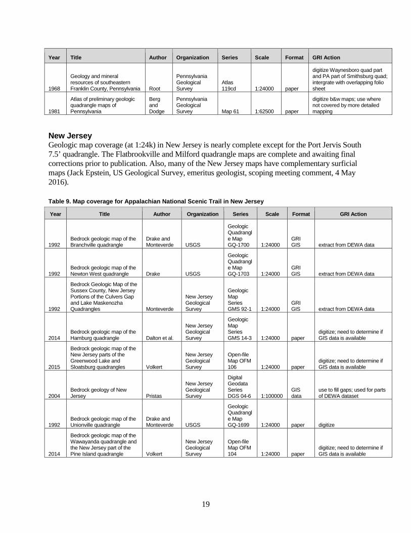
New Jersey Geologic map coverage (at 1:24k) in New Jersey is nearly complete except for the Port Jervis South 7.5’ quadrangle. The Flatbrookville and Milford quadrangle maps are complete and awaiting final corrections prior to publication. Also, many of the New Jersey maps have complementary surficial maps (Jack Epstein, US Geological Survey, emeritus geologist, scoping meeting comment, 4 May 2016). Table 9. Map coverage for Appalachian National Scenic Trail in New Jersey
Year Title Author Organization Series Scale Format GRI Action
1992 Bedrock geologic map of the Branchville quadrangle
Drake and Monteverde USGS
Geologic Quadrangle Map GQ-1700 1:24000
GRI GIS extract from DEWA data
1992 Bedrock geologic map of the Newton West quadrangle Drake USGS
Geologic Quadrangle Map GQ-1703 1:24000
GRI GIS extract from DEWA data
1992
Bedrock Geologic Map of the Sussex County, New Jersey Portions of the Culvers Gap and Lake Maskenozha Quadrangles Monteverde
New Jersey Geological Survey
Geologic Map Series GMS 92-1 1:24000
GRI GIS extract from DEWA data
2014 Bedrock geologic map of the Hamburg quadrangle Dalton et al.
New Jersey Geological Survey
Geologic Map Series GMS 14-3 1:24000 paper
digitize; need to determine if GIS data is available
2015
Bedrock geologic map of the New Jersey parts of the Greenwood Lake and Sloatsburg quadrangles Volkert
New Jersey Geological Survey
Open-file Map OFM 106 1:24000 paper
digitize; need to determine if GIS data is available
2004 Bedrock geology of New Jersey Pristas
New Jersey Geological Survey
Digital Geodata Series DGS 04-6 1:100000
GIS data
use to fill gaps; used for parts of DEWA dataset
1992 Bedrock geologic map of the Unionville quadrangle
Drake and Monteverde USGS
Geologic Quadrangle Map GQ-1699 1:24000 paper digitize
2014
Bedrock geologic map of the Wawayanda quadrangle and the New Jersey part of the Pine Island quadrangle Volkert
New Jersey Geological Survey
Open-file Map OFM 104 1:24000 paper
digitize; need to determine if GIS data is available

20
Year Title Author Organization Series Scale Format GRI Action
1986
Geologic map of the eastern parts of the Belvidere and Portland quadrangles Drake et al. USGS
Miscellaneous Investigations Series Map I-1530 1:24000
GRI GIS extract from DEWA data
1969
Geologic map and sections of parts of the Portland and Belvidere quadrangle Drake et al. USGS
Miscellaneous Geologic Investigations Map I-552 1:24000
GRI GIS extract from DEWA data
New York US Geological Survey, emeritus geologist, Nick Ratcliffe has done a lot of mapping in the New York Hudson Valley and highlands areas (Randy Orndorff, US Geological Survey, Director - Eastern Geology and Paleoclimate Center, scoping meeting comment, 4 May 2016). There is likelihood that any gaps in coverage could be filled with some of his unpublished maps. Table 10. Map coverage for Appalachian National Scenic Trail in New York
Year Title Author Organization Series Scale Format GRI Action
1992
Bedrock geologic map of the Unionville quadrangle, Orange County, New York, and Sussex County, New Jersey
Drake and Monteverde USGS
Geologic Quadrangle Map GQ-1699 1:24000
digital and paper convert digital data
?
Bedrock Map of the Greenwood Lake and Warwick 7.5 Minute Quadrangles, Orange County, New York, 1:24,000 Series
Gates and Valentino
New York State Geological Survey
OF number 1g1781 1:24000 paper
obtain scan and digitize
2001
Bedrock Geologic Map of the Monroe, New York 7.5 Minute Quadrangle
Gates and Valentino
New York State Geological Survey
OF number 1g1436 1:24000 paper
obtain scan and digitize
? Geologic Map of the Popolopen Lake
Gates and Pagano
New York State Geological Survey
OF number 1g1784 1:24000 paper
obtain scan and digitize
? Draft Geologic Map of the Popolopen Lake Quadrangle Ratcliffe USGS
OF number 1g1753 1:24000 paper
obtain draft scan (if you can) and compare with OF 1g1784
? Draft Map of Peekskill 7 1/2' quadrangle. 1:24,000 Offield
New York State Geological Survey
OF number 1gB1337 1:24000 paper
obtain scan and digitize
? Draft Map of Peekskill Quadrangle, 1:24,000 Series Ratcliffe USGS
OF number 1g1757 1:24000 paper
obtain draft scan (if you can) and compare with OF 1g1784
1968
Preliminary Geologic Map of the West Point 7.5 minute Quadrangle, New York Murray
New York State Geological Survey
Open File Map 1g1436 1:24000 paper
obtain scan and digitize
1992
Bedrock geology and seismotectonics of the Oscawana Lake quadrangle, New York Ratcliffe USGS Bulletin 1941 1:24000 paper ?

21
Year Title Author Organization Series Scale Format GRI Action
1911
Geologic Map of the Poughkeepsie (15') Quadrangle Gordon
New York State Museum Bulletin 148 1:62500 paper
obtain scan and digitize (covers Hopewell Junction quad.)
1990
Bedrock geologic map of the Poughquag quadrangle, New York
Ratcliffe and Burton USGS
Geologic Quadrangle Map GQ-1662 1:24000 paper
obtain scan and digitize
?
Draft Geologic Map of the Pawling Quadrangle, 1:24,000 series
Fisher and McLelland
New York State Geological Survey
OF number 1g1261 1:24000 paper
obtain scan and digitize
? Geologic map of Dover Plains 7 1/2' Carroll
New York State Geological Survey
OF number 1g050 1:24000 paper
obtain scan and digitize (compare with unpublished from CT)
1970 Geologic map of New York - lower Hudson sheet Rickard et al.
New York State Museum and Science Service
Map and Chart Series 15 1:250000 GIS data
use to fill gaps; used for parts of DEWA dataset
Connecticut Geologic map coverage over the six 7.5’ quadrangles the Appalachian Trail crosses is complete. Although some maps are listed as unpublished, they may have actually been peer reviewed and assigned an open file number. Table 11. Map coverage for Appalachian National Scenic Trail in Connecticut
Year Title Author Organization Series Scale Format GRI Action
1975
Bedrock geology of the South Canaan quadrangle, Connecticut Gates
Connecticut Geological and Natural History Survey
Quadrangle Report 32 1:24000 paper digitze entire quad
1979
Bedrock geologic map of the Sharon quadrangle, Connecticut Gates
Connecticut Geological and Natural History Survey
Quadrangle Report 38 1:24000 paper digitze entire quad
1985 Bedrock Geological Map of Connecticut Rodgers
State of Connecticut, Department of Environmental Protection ? 1:50000 digital
might use to fill in the gaps at Ellsworth and Dover Plains
1998 Bedrock Geologic Map of the Kent Quadrangle, CT Jackson
Connecticut Geological and Natural History Survey
Open File OF-98-1 1:24000
digital and paper convert digital data
1966
Geologic map of the Bashbish Falls quadrangle, Massachusetts, Connecticut, and New York
Zen and Hartshorn USGS
Geologic Quadrangle Map GQ-507 1:24000 paper digitize entire quad
?
Unpublished Dover Plains from Connecticut Geological and Natural History Survey Jackson
Connecticut Geological and Natural History Survey Unpublished ? ?
possible gap. There is a 1x2 that covers the area

22
Massachusetts Geologic map coverage of the Appalachian Trail in Massachusetts is complete. A statewide slope stability map (1:125,000 scale) also exists. Table 12. Map coverage for Appalachian National Scenic Trail in Massachusetts
Year Title Author Organization Series Scale Format GRI Action
1971
Bedrock geologic map of the Egremont quadrangle and adjacent areas, Berkshire County, Massachusetts, and Columbia County, New York
Zen and Ratcliffe USGS
Miscellaneous Geologic Investigations Map I-628 1:24000 paper digitize entire quad
1966
Geologic map of the Bashbish Falls quadrangle, Massachusetts, Connecticut, and New York
Zen and Hartshorn USGS
Geologic Quadrangle Map GQ-507 1:24000 paper digitize entire quad
1974
Bedrock geologic map of the Great Barrington quadrangle, Berkshire County, Massachusetts Ratcliffe USGS
Geologic Quadrangle Map GQ-1141 1:24000 paper digitize entire quad
1984
Bedrock geologic map of the Monterey quadrangle, Berkshire County, Massachusetts Ratcliffe USGS
Geologic Quadrangle Map GQ-1572 1:24000 paper digitize entire quad
1985
Bedrock geologic map of the East Lee quadrangle, Berkshire County, Massachusetts Ratcliffe USGS
Geologic Quadrangle Map GQ-1573 1:24000 paper digitize entire quad
1984
Bedrock geologic map of the Pittsfield East quadrangle, Berkshire County, Massachusetts Ratcliffe USGS
Geologic Quadrangle Map GQ-1574 1:24000 paper digitize entire quad
1993
Bedrock geologic map of the Williamstown and North Adams quadrangles, Massachusetts and Vermont, and part of the Cheshire quadrangle, Massachusetts
Ratcliffe et al. USGS
Miscellaneous Investigations Series Map I-2369 1:24000 paper digitize entire quad
1958
Bedrock geology of the Cheshire quadrangle, Massachusetts Herz USGS
Geologic Quadrangle Map GQ-108 1:24000 paper
crop out missing section of Cheshire
Vermont Vermont has 1:24,000-scale bedrock maps but they are not all considered published and available digitally. The GRI map team should contact the Vermont Geological Survey to determine access to the maps for the following quadrangles: Hanover, Quechee, Woodstock North, Delectable Mountain, Pico Peak, Killington Peak, Rutland, Wallingford, Danby, Peru, Stratton Mountain, Sunderland, Woodford, and Stamford.

23
Table 13. Map coverage for Appalachian National Scenic Trail in Vermont
Year Title Author Organization Series Scale Format GRI Action
2011 Bedrock geologic map of Vermont
Ratcliffe et al. USGS
Scientific Investigations Map SIM-3184 1:100000
digital and paper
convert digital data (only APPA QOI's)
New Hampshire Map coverage in New Hampshire exists at 1:62,500-scale for all but the Jackson 7.5’ quadrangle. Mapping this area would be an ideal project for a student. In addition to the maps listed in the table below, a Mount Washington map and Mount Dartmouth maps have been completed at 1:3,000-scale. Table 14. Map coverage for Appalachian National Scenic Trail in New Hampshire
Year Title Author Organization Series Scale Format GRI Action
2015
Bedrock Geologic Map of the Hanover 7.5 minute Quadrangle Thompson
New Hampshire Geological Survey
Map Geo-091-024000-BMOF 1:24000
digital and paper convert digital data
2014 Geologic Map of the Enfield, NH 7.5 Minute Quadrangle Thompson
New Hampshire Geological Survey
Open-File Reports Geo-092-024000-BMOF 1:24000
digital and paper convert digital data
2008 Bedrock Geology map of the Lyme 7.5 Minute Quadrangle Thompson
New Hampshire Geological Survey
Digital Geodata Series Geo-080-024000-BMOF 1:24000 digital convert digital data
2008
Bedrock Geologic map of the Smarts Mountain Quadrangle, Grafton County, New Hampshire Thompson
New Hampshire Geological Survey
Map Geo-081-024000-BMOF 1:24000
digital and paper convert digital data
2015
Bedrock Geology of the Mt. Dartmouth 7.5 minute Quadrangle
Eusden et al.
New Hampshire Geological Survey
Map Geo-046-024000-BMOF 1:24000
digital and paper convert digital data
1958
Geologic Map and Structure Sections of the Hanover Quadrangle Lyons
New Hampshire Geological Survey
Map Geo-029-062500-BMAP 1:62500
digital and paper
convert digital data (coarser scale than above maps to fill in any missing areas)
1938
Geologic Map and Structure Sections of the Mascoma Quadrangle, New Hampshire Chapman
Geological Society of America
Map and Chart Series Geo-030-062500-BMAP 1:62500
digital and paper
convert digital data (coarser scale than above maps to fill in any missing areas)
1938
Geologic Map and Structure Sections of the New Hampshire Portions of the Mt. Cube Quadrangle Hadley
New Hampshire Geological Survey
Map Geo-023-062500-BMAP 1:62500
digital and paper
convert digital data (coarser scale than above maps to fill in any missing areas)

24
Year Title Author Organization Series Scale Format GRI Action
1940
Geologic map and Structure Sections of the Rumney Quadrangle, New Hampshire Page
New Hampshire State Planning and Development Commission
Geologic Maps Geo-024-062500-BMAP 1:62500
digital and paper
convert digital data (coarser scale than above maps to fill in any missing areas)
1935
Geologic map and structure sections of the Moosilauke quadrangle, Grafton County, New Hampshire Billings
New Hampshire Department of Environmental Services
Geologic Quadrangle Map Geo-018-062500-BMA 1:62500 paper
digitize (coarser scale than above maps to fill in any missing areas)
1935
Bedrock Geologic map of the Franconia Quadrangle, New Hampshire
Billings, and Williams
New Hampshire Geological Survey
Map Geo-019-062500-BMAP 1:62500
digital and paper
convert digital data (coarser scale than above maps to fill in any missing areas)
1977 Geology of the Crawford Notch Quadrangle, New Hampshire
Henderson et al.
New Hampshire Geological Survey
Map Geo-020-062500-BMAP 1:62500
digital and paper
convert digital data (coarser scale than above maps to fill in any missing areas)
1945
Geologic Map and Structure Sections of the Mt. Washington Quadrangle, New Hampshire
Billings et al.
New Hampshire Geological Survey
Map Geo-015-062500-BMAP 1:62500
digital and paper
convert digital data (coarser scale than above maps to fill in any missing areas)
1975 Geology of the Gorham Quadrangle, New Hampshire
Billings and Fowler-Billings
New Hampshire Geological Survey
Map Geo-016-062500-BMAP 1:62500
digital and paper
convert digital data (coarser scale than above maps to fill in any missing areas)
Maine The only map with seamless and digitized coverage of the Appalachian Trail in Maine is a compiled 1:500,000-scale state bedrock geologic map (available at http://maine.gov/dacf/mgs/explore/bedrock/index.shtml). Detailed mapping exists at various scales, but it is not compiled and may not be digitized yet. A gap in detailed maps occurs over the Greenville and Barren Mountain East and West quadrangles. The quadrangles only have surficial materials maps available (just points on a map) which could not feed into the GRI data model. The surficial geologic map of the Millinocket quadrangle covers these areas but is the same data that is on the state 1:500,000-scale map. Table 15. Map coverage for Appalachian National Scenic Trail in Maine
Year Title Author Organization Series Scale Format GRI Action
1985 Bedrock geology of the Pierce Pond 15' quadrangle, Maine Boone
Maine Geological Survey
Open-File Map 85-86 1:62,500 pdf digitize entire quad
1981
Reconnaissance bedrock geology of the The Forks [15-minute] quadrangle, Maine
Burroughs and Marvinney
Maine Geological Survey
Open-File Map 81-10 1:62500 pdf digitize entire quad
1973
Metamorphic stratigraphy, petrology, and structural geology of the Little Bigelow Mountain map area, western Maine Boone
Maine Geological Survey Bulletin 24 1:62500 ? digitize entire quad

25
Year Title Author Organization Series Scale Format GRI Action
1977
Geology of the Oquossoc 15' quadrangle, west-central Maine Guidotti
Maine Geological Survey
Open-File Report 77-2 1:62500 pdf digitize entire quad
1971
Geologic map of the Rangeley and Phillips quadrangles, Franklin and Oxford Counties, Maine Moench USGS
Miscellaneous Geologic Investigations Map I-605 1:62500 pdf digitize entire quad
1976
Geologic map of the Rumford quadrangle, Oxford and Franklin Counties, Maine
Moench and Hildreth USGS GQ-1272 1:62500 pdf digitize entire quad
1967
Geology and petrology of the Greenville quadrangle, Piscataquis and Somerset Counties, Maine
Espenshade and Boudette USGS
Bulletin 1241-F 1:62500
digital and paper convert digital data
1972
Geology of the Moxie pluton in the Moosehead Lake - Jo-Mary Mountain area, Piscataquis County, Maine Espenshade USGS
Bulletin 1340 1:62500
digital and paper convert digital data
2010
A guide to the geology of Baxter State Park and Katahdin Rankin et al.
Maine Geological Survey
Bulletin 43, 80 p., 2 color maps 1:100000 paper digitize APPA portion
1985 Bedrock geology of the Pierce Pond 15' quadrangle, Maine Boone
Maine Geological Survey
Open-File Map 85-86 1:62,500 pdf digitize entire quad
1981
Reconnaissance bedrock geology of the The Forks [15-minute] quadrangle, Maine
Burroughs and Marvinney
Maine Geological Survey
Open-File Map 81-10 1:62500 pdf digitize entire quad
26
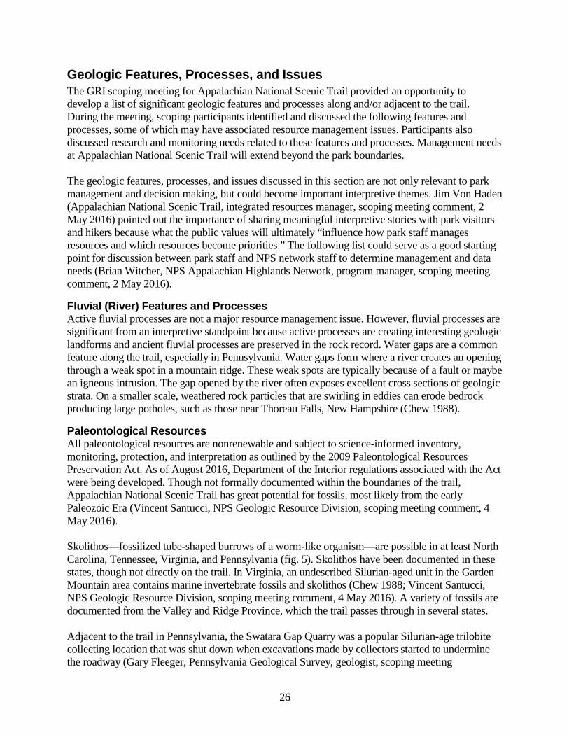
Geologic Features, Processes, and Issues The GRI scoping meeting for Appalachian National Scenic Trail provided an opportunity to develop a list of significant geologic features and processes along and/or adjacent to the trail. During the meeting, scoping participants identified and discussed the following features and processes, some of which may have associated resource management issues. Participants also discussed research and monitoring needs related to these features and processes. Management needs at Appalachian National Scenic Trail will extend beyond the park boundaries. The geologic features, processes, and issues discussed in this section are not only relevant to park management and decision making, but could become important interpretive themes. Jim Von Haden (Appalachian National Scenic Trail, integrated resources manager, scoping meeting comment, 2 May 2016) pointed out the importance of sharing meaningful interpretive stories with park visitors and hikers because what the public values will ultimately “influence how park staff manages resources and which resources become priorities.” The following list could serve as a good starting point for discussion between park staff and NPS network staff to determine management and data needs (Brian Witcher, NPS Appalachian Highlands Network, program manager, scoping meeting comment, 2 May 2016).
Fluvial (River) Features and Processes Active fluvial processes are not a major resource management issue. However, fluvial processes are significant from an interpretive standpoint because active processes are creating interesting geologic landforms and ancient fluvial processes are preserved in the rock record. Water gaps are a common feature along the trail, especially in Pennsylvania. Water gaps form where a river creates an opening through a weak spot in a mountain ridge. These weak spots are typically because of a fault or maybe an igneous intrusion. The gap opened by the river often exposes excellent cross sections of geologic strata. On a smaller scale, weathered rock particles that are swirling in eddies can erode bedrock producing large potholes, such as those near Thoreau Falls, New Hampshire (Chew 1988).
Paleontological Resources All paleontological resources are nonrenewable and subject to science-informed inventory, monitoring, protection, and interpretation as outlined by the 2009 Paleontological Resources Preservation Act. As of August 2016, Department of the Interior regulations associated with the Act were being developed. Though not formally documented within the boundaries of the trail, Appalachian National Scenic Trail has great potential for fossils, most likely from the early Paleozoic Era (Vincent Santucci, NPS Geologic Resource Division, scoping meeting comment, 4 May 2016). Skolithos—fossilized tube-shaped burrows of a worm-like organism—are possible in at least North Carolina, Tennessee, Virginia, and Pennsylvania (fig. 5). Skolithos have been documented in these states, though not directly on the trail. In Virginia, an undescribed Silurian-aged unit in the Garden Mountain area contains marine invertebrate fossils and skolithos (Chew 1988; Vincent Santucci, NPS Geologic Resource Division, scoping meeting comment, 4 May 2016). A variety of fossils are documented from the Valley and Ridge Province, which the trail passes through in several states. Adjacent to the trail in Pennsylvania, the Swatara Gap Quarry was a popular Silurian-age trilobite collecting location that was shut down when excavations made by collectors started to undermine the roadway (Gary Fleeger, Pennsylvania Geological Survey, geologist, scoping meeting

27
presentation, 4 May 2016). Silurian-age trilobite trace fossils also occur at the pinnacle overlook in Pennsylvania but far removed from the trail (Vincent Santucci, NPS Geologic Resource Division, scoping meeting comment, 4 May 2016) Additionally, plant fossils have been recovered from DeHart Reservoir in Pennsylvania (Vincent Santucci, NPS Geologic Resource Division, scoping meeting comment, 4 May 2016). Fossil fish scales occur where the trail crosses the Delaware River (Jack Epstein, US Geological Survey, emeritus geologist, scoping meeting comment, 4 May 2016). Conodonts and/or graptolites may occur in rocks along the trail in Vermont.
Figure 5. Photograph of skolithos fossils. Skolithos are common in the quartzites of South Mountain, Pennsylvania. Photograph by Gary Fleeger (Pennsylvania Geological Survey).
Glacial Record The northern half of the Appalachian Trail shows evidence of Pleistocene glaciation while the southern half does not because glaciers never extended that far south. The transition from glaciated to unglaciated terrain occurs along the trail in Pennsylvania (fig. 4). Bedrock in Pennsylvania shows striations from Wisconsinan glaciation (fig. 6). Glacial polish on bedrock also occurs at Eph’s Lookout near the Pine Cobble Trail in northern Massachusetts (Chew 1988). Also in Massachusetts, near the Appalachian Trail but not directly on it, is Natural Bridge State Park. This is the location of an old commercial marble quarry. The park hosts a deep gorge, produced by glacial meltwater streams, that cuts deeply into the marble along joint sets creating a natural marble arch (Joe Kopera,

28
Massachusetts Geological Survey, geologist, scoping meeting comment, 6 May 2016). The Appalachian Trail crosses the former location of an ancient glacial lake, Lake Albany, near Bear Mountain. Glacial erratics occur near the trail in Connecticut (fig. 7); the Roger’s ramp section of the trail passes through a glacial erratic that has split in half. In New Hampshire, relict rock glaciers and patterned ground occur in the presidential range on Mount Washington. A glacial cirque is present on Mount Washington (Chew 1988). In Maine, Mahoosuc Mountain and Mount Katahdin exhibit classic alpine glacier-formed features such as cirques, eskers, and moraines. South of the Wisconsinan glacial border, periglacial features—related to areas at the edge of glaciers—are present but glacial features are absent. Boulder fields, which formed in response to repeated freezing and thawing cycles, occur in Tennessee, West Virginia, and Pennsylvania. These areas may provide habitat for bats. Geologic features along the Appalachian Trail also show evidence of pre-Pleistocene Glaciation. Lithified glacial lake deposits and till occur in Virginia. A glacier formed in the Mount Rogers area of Virginia sometime near the end of the Precambrian (more than 500 million years ago). Glacial till deposited at this time hardened into a rock called tillite or diamictite. Where the glacier ended in water, varve deposits—light colored sand in summer and dark mud in winter—settled under the surface of the ice and are now preserved in rock in the valley on the north side of Mount Rogers (Chew 1988). Dropstones which fell from melting icebergs are also in the rock (Chew 1988).
Figure 6. Photograph of striated bedrock. Rocks along the trail near Lake Lenape exhibit glacial striations. Photograph by Gary Fleeger (Pennsylvania Geological Survey).

29
Figure7. Photograph of a glacial erratic. Giant’s thumb is an 8-ft-tall glacial erratic near the trail in Connecticut. Photograph courtesy of James Bogart (Connecticut Geological Survey).
Caves and Karst Cave features are nonrenewable resources. The Federal Cave Resources Protection Act of 1988 requires the identification of “significant caves” in NPS areas, the regulation or restriction of use as needed to protect cave resources and inclusion of significant caves in land management planning. The act also imposes penalties for harming a cave or cave resources and exempts park managers from releasing specific location information for significant caves in response to a FOIA request. A cave inventory has not been completed for Appalachian National Scenic Trail. Caves are documented in the Shady Valley Dolomite of North Carolina and Tennessee, though they are not abundant and not directly on the trail. In Maryland, quadrangles to the west of the trail were mapped for karst (David Brezinski, Maryland Geological Survey, geologist, scoping meeting comment, 4 May 2016). In Pennsylvania, karst occurs where the trail crosses the Cumberland Plateau and in the Great Valley. The Pennsylvania Geological Survey indicated at the scoping meeting that they may have karst maps available in the area of the trail. Caves do not occur near the trail in Connecticut. Ice caves are located in Stockbridge, Massachusetts (Joe Kopera, Massachusetts Geological Survey, geologist, scoping meeting comment, 6 May 2016). Talus caves occur in the Mahoosuc Range on the border between Maine and New Hampshire. Caves provide habitat for wildlife, including some which are federally listed threatened or endangered species. For example, boulder fields create small caves which are known to be inhabited by small-footed bats (Brian Witcher, NPS Appalachian Highlands Network, program manager, scoping meeting comment, 2 May 2016). The GRI geologic map data could be used to help identify potential small-footed bat habitat.

30
Geothermal Features and Springs The Geothermal Steam Act of 1970, as amended in 1988 (see Appendix B), prohibits geothermal leasing in parks, and authorizes the Secretary of the Interior to mitigate or not issue geothermal leases outside parks that would have a significant adverse impact on significant thermal features in the 16 park units listed in the act. Appalachian National Scenic Trail is not included on the list of 16 parks that are designated under the act as having significant thermal features. There is a hot spring in the Shady Valley Dolomite in North Carolina. The spring is 105° Fahrenheit—just barely able to be called a “hot” spring. The spring is not heated geothermally and is not related to fracking. Rain water infiltrates the subsurface along inactive faults where it is heated as a result of the natural thermal gradient and therefore returns to the surface warm (Kenneth Taylor, North Carolina Geological Survey, state geologist, scoping meeting comment, 2 may 2016). Manganese is present in spring water at this location. Boiling springs is a spring in Pennsylvania, but it is not a geothermal spring. The water is not hot or even warm. It gets its name from the boiling appearance of water that is forced to the surface as a result of a Jurassic-age diabase dike which forms a barrier (fig. 8; Gary Fleeger, Pennsylvania Geological Survey, geologist, scoping meeting presentation, 4 May 2016). In Connecticut, Marble Springs is a natural underground spring which can be seen at ground surface just southeast of the “Limestone Spring Lean-to” official shelter. The spring water is considered to be very clean and drinkable (Margaret Thomas, Connecticut Geological Survey, state geologist, scoping meeting comment, 6 May 2016). In Massachusetts, a 72° Fahrenheit “hot” spring occurs which may be considered a historical resource related to geology on the Appalachian Trail (Joe Kopera, Massachusetts Geological Survey, geologist, scoping meeting comment, 6 May 2016). These are meteoric waters that infiltrate and are heated by the natural geothermal gradient before returning to the surface. The Sand Spring Recreational Center is located just west of the Appalachian Trail in Williamstown, Massachusetts (Stephen Mabee, Massachusetts Geological Survey, state geologist, scoping meeting comment, 6 May 2016).

31
Figure 8. Photograph of Boiling springs. Boiling springs in Pennsylvania is not actually boiling, it gets its name from the appearance that the water is boiling. Photograph by Gary Fleeger (Pennsylvania Geological Survey).
Slope Movements Anywhere steep slopes and/or loose rock or soil occur there is the potential for slope movements. Additionally, trail construction and maintenance has the potential to trigger slope movements. Trails should not be cut on slopes such that bedding planes (surfaces separating layers of rock) dip down and toward the trail. Large debris flows occurred in Great Smoky Mountains National Park a couple years ago, but these did not impact the Appalachian Trail (Bart Cattanach, North Carolina Geological Survey, geologist, scoping meeting comment, 2 May 2016). In Pennsylvania, a large rockfall occurred at Lehigh Gap (Jack Epstein, US Geological Survey, emeritus geologist, scoping meeting comment, 4 may 2016). A debris flow occurred in Shenandoah National Park in the mid-1990s; Dave Steensen of the NPS Geologic Resources Division was involved in the response and should be consulted during the preparation of the GRI report. In Massachusetts, landslide scars on Mount Greylock are visible on Lidar maps and on mountain viewing from the east (Joe Kopera, Massachusetts Geological Survey, geologist, scoping meeting comment, 6 May 2016). In New Hampshire, the Willey slide of 1827 killed 9 people and restricted travel in and out of Crawford Notch. Curious tourists came up to see the White Mountains following the event. The Carter Dome quadrangle geologic map has one landslide deposit mapped right on the Appalachian Trail, which is unusual for a bedrock map (Rick Chormann, New Hampshire Geological Survey,

32
state geologist, scoping meeting presentation, 6 May 2016). Rock slides were documented in King Ravine, New Hampshire (Chew 1988).
Seismic Activity Appalachian National Scenic Trail is not in a very seismically active area, however, earthquakes do occur. The Southern Appalachian Seismic Zone, which runs from Alabama to West Virginia, activates periodically every 40–60 years and we are coming up on the peak of it (Kenneth Taylor, North Carolina Geological Survey, state geologist, scoping meeting comment, 2 may 2016). The Federal Emergency Management Agency placed the Lancaster Seismic Zone in Pennsylvania in the moderate risk category. Earthquakes occur in New York and Vermont every once in a while, likely related to Mesozoic-age faults along the Hudson River (Randy Orndorff, US Geological Survey, Director - Eastern Geology and Paleoclimate Center, scoping meeting comment, 4 May 2016). Following an earthquake in 2011, a USGS team documented slides along the Blue Ridge Parkway because it was suspected the two were related (Matt Heller, Virginia Division of Geology and Mineral Resources, geologist supervisor, scoping meeting comment, 4 May 2016). The Weston Observatory at Boston College monitors seismic activity in New England; shaking occurs but almost never causes damage or is strong enough to be felt.
Abandoned Mineral Lands Acid producing rocks probably occur along the trail in North Carolina; further investigation is required to pinpoint locations (fig. 9; Bart Cattanach, North Carolina Geological Survey, geologist, scoping meeting comment, 2 May 2016).
Figure 9. Map of mines near the Appalachian Trail in North Carolina. Acid producing rocks probably occur along the trail in North Carolina. Further investigation is required to pinpoint locations. Graphic by Bart Cattanach (North Carolina Geological Survey).
Anthracite coal mining and coal towns are part of the history of Pennsylvania and acid mine drainage occurs along the Appalachian Trail (Gary Fleeger, Pennsylvania Geological Survey, geologist, scoping meeting presentation, 4 May 2016). The “Palmerton Zinc Superfund Site” at

33
Lehigh Gap is devoid of vegetation due to zinc smelting in Palmerton; it is currently a superfund site and remediation is ongoing. For the few miles where the Appalachian Trail approaches Lehigh Gap there is little vegetation on Blue Mountain (fig. 10). There is a slate belt to the south of the trail in Pennsylvania and slate dumps and abandoned quarries occur near the trail. The Appalachian Trail passes several coal mining ghost towns, such as Rausch Gap and Yellow Springs. Just after passing through Rausch Gap, the trail passes a long abandoned strip mine situated on the Mammoth coal seam (Gary Fleeger, Pennsylvania Geological Survey, geologist, scoping meeting presentation, 4 May 2016). The trail passes near Fuller Lake in Pine Grove Furnace State Park. It is an abandoned 90-ft-deep iron ore pit (Gary Fleeger, Pennsylvania Geological Survey, geologist, scoping meeting presentation, 4 May 2016).
Figure 10. Photograph of the Appalachian Trail approaching Lehigh Furnace Gap. Lehigh Gap is devoid of vegetation due to zinc smelting in Palmerton. Photograph by Gary Fleeger (Pennsylvania Geological Survey).
Many abandoned mines exist in New York, some near Appalachian National Scenic Trail. The Phillips mine may be an issue along the Appalachian Trail due to acid mine drainage, the potential for radioactive uraninite, and the close proximity to hikers on the trail (Bill Kelly, New York Geological Survey, state geologist, scoping meeting presentation, 6 May 2016). Northwest Connecticut was the foremost iron producer for the country for over 200 years starting in the mid 18th century. Civil War Landmarks remain at many points along the Appalachian Trail in Connecticut. Iron furnace ruins are located at Great Falls and Bull’s Bridge sites, as well as charcoal

34
pits lining the trail from the base of Bear Mountain to the Riga campsite (James Bogart, Connecticut Geological Survey, intern, scoping meeting presentation, 6 May 2016). Iron ore deposits come from the Walloomsac Schist near the contact with the underlying Stockbridge Marble. Iron deposits are “bog ore” type, where iron precipitated from iron rich waters of the ancient Iapetus Ocean. The hazard potential of former iron operations in Connecticut in relation to the Appalachian Trail is not known at this time. The Connecticut Geological Survey could do site visits for mines/quarries and assess their hazard level (Margaret Thomas, Connecticut Geological Survey, state geologist, scoping meeting comment, 6 May 2016). In New Hampshire, the Appalachian Trail passes an old lead, copper, and zinc mine that may be a superfund site now (Rick Chormann, New Hampshire Geological Survey, state geologist, scoping meeting presentation, 6 May 2016). The mine was abandoned in 1915. The owners left several piles of tailings and waste rock on site. When water ran through the tailings and waste rock it became contaminated and impacted water quality and aquatic species downstream in Ore Hill Brook (Rick Chormann, New Hampshire Geological Surve, state geologist, scoping meeting presentation, 6 May 2016).
External Energy Development The potential exists for energy development adjacent to or within the viewshed of Appalachian National Scenic Trail which may impact the quality of resources along the trail. Renewable energy operations, specifically wind turbines, are proposed in Main and Vermont. Wind turbine designs are getting progressively taller, increasing their potential to impact the trail and its resources. NPS staff at the park is already working with GRD staff to address these issues. There are currently around ten proposals for gas pipelines to cross the trail (Wendy Janssen, Appalachian National Scenic Trail, superintendent, scoping meeting comment, 6 May 2016). Mining operations near the trail could include crushed stone operations in North Carolina; prospecting for uranium in granite, as well as iron and manganese in Tennessee; metal deposits associated with a pluton in Maine; and glacial till gravel pits.

35
Literature Cited Appalachian Trail Conservancy. 2009. Local Management Planning Guide. Revised April 2009. Appalachian Trail Conservancy, Harpers Ferry, West Virginia. Carter, M. W., Merschat, C. E., and Wilson, W. F. 1999. A geologic adventure along the Blue Ridge Parkway in North Carolina. Bulletin 98. Chew, V. C. 1988. Underfoot: a geologic guide to the Appalachian Trail. 2nd edition. Appalachian Trail Conference, Harpers Ferry, West Virginia. Moore, H. L. 1988. A roadside guide to the geology of the Great Smoky Mountains National Park. The University of Tennessee Press, Knoxville, Tennessee. Rankin, D. W., and Caldwell, D. W. 2010. A guide to the geology of Baxter State Park and Katahdin. Bulletin 43. Maine Geological Survey, Department of Conservation, Augusta, Maine. Thornberry-Ehrlich, T. L. 2008. Great Smoky Mountains National Park: geologic resource evaluation report. Natural Resource Report NPS/NRSS/GRD/NRR—2008/048. National Park Service, Denver, Colorado. Thornberry-Ehrlich, T. L. 2013. Delaware Water Gap National Recreation Area: geologic resources inventory report. Natural Resource Report NPS/NRSS/GRD/NRR—2013/717. National Park Service, Fort Collins, Colorado. Thornberry-Ehrlich, T. L. 2014. Shenandoah National Park: geologic resources inventory report. Natural Resource Report NPS/NRSS/GRD/NRR—2014/767. National Park Service, Fort Collins, Colorado. Wilshusen, J. P. 1983. Geology of the Appalachian Trail in Pennsylvania. General Geology Report 74. Pennsylvania Geological Survey, Harrisburg, Pennsylvania.