Embed Size (px)
Citation preview

Natural Resources Planning for Climate Change: Extreme Climate
Events and Communities ‘I don’t mean to sound ungrateful but while you were saving my house my livelihood went up in smoke.’
Final Report PREPARED FOR: SOUTH EAST LOCAL LAND SERVICES
AUTHORS Brent Jacobs Louise Boronyak- Vasco

ii Institute for Sustainable Futures
Extreme climate events and communities in the South East
UTS:INSTITUTE FOR SUSTAINABLE FUTURES OCTOBER 2014 ABOUT THE AUTHORS The Institute for Sustainable Futures (ISF) was established by the University of Technology, Sydney in 1996 to work with industry, government and the community to develop sustainable futures through research and consultancy. Our mission is to create change toward sustainable futures that protect and enhance the environment, human well-being and social equity. We seek to adopt an inter-disciplinary approach to our work and engage our partner organisations in a collaborative process that emphasises strategic decision-making. For further information visit: www.isf.uts.edu.au Institute for Sustainable Futures University of Technology, Sydney PO Box 123 Broadway, NSW, 2007 2014 © UTS
iii Institute for Sustainable Futures
Extreme climate events and communities in the South East
TABLE OF CONTENTS 1 Executive Summary iv
2 Introduction 8
3 Method 10
3.1 South East NSW climate drivers 11 3.2 Regional hazard mapping 12 3.3 Identifying Vulnerability 12 3.4 Workshop process 12 3.4.1 Activity 1: Plenary discussion 12 3.4.2 Activity 2: Small group discussion 14 3.4.3 Workshop evaluation 14 3.4.4 Project funding 14
4 Natural resource management and Hazards in the South East 15 4.1 Extreme climate events 15 4.1.1 Bushfire exposure 15 4.1.2 Drought 23 4.1.3 Storms and Flood 28
5 Discussion 34
6 Recommendations 40
7 References 42
8 Appendix 1: 44
9 Appendix 2: 44

iv Institute for Sustainable Futures
Extreme climate events and communities in the South East
1 EXECUTIVE SUMMARY This report provides a synthesis of the findings from a series of workshops that focused on the management of natural resources for extreme events in the South East region of NSW.
Natural resources directly support the livelihoods of rural society and underpin much of the economic activity of rural and regional Australia (Crossman and Bryan 2009, Kokic et al 2006). The impact of extreme climate events such as bushfire, floods and drought in rural and regional areas can be devastating and disruptive to social and economic activity (Bosomworth and Handmer, 2008). Projections of future climate suggest that changes in the frequency and or severity of extreme climatic events are likely to occur (Richardson et al 2013).
The New South Wales Government has a well-developed emergency service process for managing the impacts of natural disasters and has implemented a State Emergency Management Plan (http://www.emergency.nsw.gov.au/media/1621.pdf). The Plan uses a 4-phase framework of prevention, preparation, response and recovery (PPRR). In the event of a natural disaster this framework is applied to inform Government and its combat and support agencies of the appropriate administrative and operational responses throughout the duration of the event. While the Plan recognises the importance of reducing the level of risk to communities during the prevention and preparation phases, and the restoration of the environment during recovery, in practice it focuses primarily and necessarily on saving lives and protecting property before, during and after an extreme event.
This report seeks to address key questions in relation to the protection of natural resources from extreme climate events:
• Is the PPRR emergency management cycle meaningful for the range of events experienced by rural and regional communities throughout South East NSW?
• How does Government’s view of a community’s progress through the PPRR cycle accord with the lived experience of that community?
• In practice, how are natural resources currently considered in the management of extreme climate events?
• How can natural resource management be improved to ensure the prosperity and viability of rural and regional communities for an uncertain future?
The Research Team from ISF in collaboration with the South East Local Land Services employed a place-based participatory workshop process with participants drawn from the communities of the South East of NSW representing farmers, landholders, emergency service volunteers, local and state government, business owners, Indigenous peoples, financial institutions and a range of non-government organisations such as Landcare.
To inform the workshop participants we provided:
• An overview of the climate drivers and potential hazards faced by communities in the South East; and
• Hazard mapping which considered the influence of a number of factors such as topography, aspect, vegetation, prevailing wind activity and soil types – all of which contribute to the level of exposure in each landscape.

v Institute for Sustainable Futures
Extreme climate events and communities in the South East
Figure 1: Bushfire hazard map for the SE Region of New South Wales (Source: NSW OEH)
Each workshop involved the delivery of two facilitated sessions, in which qualitative data were collected during:
• An open plenary discussion: the first part of each workshop utilised the emergency management cycle - Prevent, Prepare, Respond and Recover (PPRR) and discussions were based around the most important local hazards – bushfires, drought or storms and flooding; and
• Small interest group discussions: the second part of the workshops was designed to specifically address the actions taken to manage natural resources and aspects of community capacity to undertake management actions in each phase of the PPRR cycle.
LegendFireRiskbyFuelLoadDrynessWindExposurex100intValue
High : 638
Low : 101
vi Institute for Sustainable Futures
Extreme climate events and communities in the South East
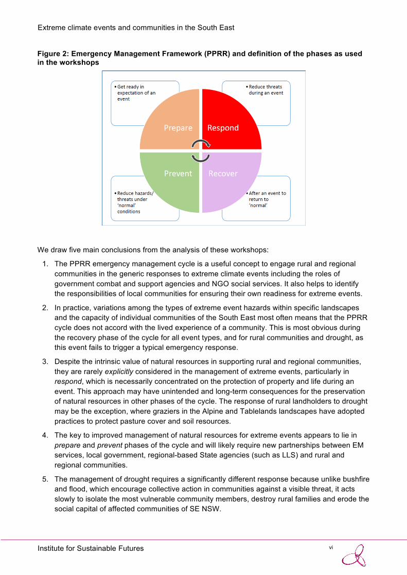
Figure 2: Emergency Management Framework (PPRR) and definition of the phases as used in the workshops
We draw five main conclusions from the analysis of these workshops:
1. The PPRR emergency management cycle is a useful concept to engage rural and regional communities in the generic responses to extreme climate events including the roles of government combat and support agencies and NGO social services. It also helps to identify the responsibilities of local communities for ensuring their own readiness for extreme events.
2. In practice, variations among the types of extreme event hazards within specific landscapes and the capacity of individual communities of the South East most often means that the PPRR cycle does not accord with the lived experience of a community. This is most obvious during the recovery phase of the cycle for all event types, and for rural communities and drought, as this event fails to trigger a typical emergency response.
3. Despite the intrinsic value of natural resources in supporting rural and regional communities, they are rarely explicitly considered in the management of extreme events, particularly in respond, which is necessarily concentrated on the protection of property and life during an event. This approach may have unintended and long-term consequences for the preservation of natural resources in other phases of the cycle. The response of rural landholders to drought may be the exception, where graziers in the Alpine and Tablelands landscapes have adopted practices to protect pasture cover and soil resources.
4. The key to improved management of natural resources for extreme events appears to lie in prepare and prevent phases of the cycle and will likely require new partnerships between EM services, local government, regional-based State agencies (such as LLS) and rural and regional communities.
5. The management of drought requires a significantly different response because unlike bushfire and flood, which encourage collective action in communities against a visible threat, it acts slowly to isolate the most vulnerable community members, destroy rural families and erode the social capital of affected communities of SE NSW.

vii Institute for Sustainable Futures
Extreme climate events and communities in the South East
In addition we propose a hypothetical extreme event time line based on a synthesis of information from all of the workshops to improve the management of natural resources.
Figure 3: Improved theoretical extreme event timeline. Improvements to the individual activity lines are shown in black.

8 Institute for Sustainable Futures
Extreme climate events and communities in the South East
2 INTRODUCTION Natural resources directly support the livelihoods of rural society and underpin much of the economic activity of rural and regional Australia (Crossman and Bryan 2009, Kokic et al 2006). Australia’s natural resource base is in decline and climate change poses an additional threat to the sustainable management of land, water and biodiversity (Richardson et al 2013). The impact of extreme climate events such as bushfire, floods and drought in rural and regional areas can be devastating and disruptive to social and economic activity (Bosomworth and Handmer, 2008). If the events result in a step-change in the supply of ecosystem services through, for example, top soil erosion, surface water pollution and local plant and animal extinctions, the consequences for rural and regional communities can be a permanent loss of natural capital and flow on impacts to social cohesion and accelerated rural decline.
Projections of future climate suggest that changes to the frequency and or severity of extreme climate events is likely to occur (Richardson et al 2013). The severity and frequency of events combine to determine the interval required for recovery of social-ecological systems. If the frequency of recurrence is greater than the rate at which the system recovers its pre-event level of function then the socio-ecological system can be pushed beyond certain thresholds, most likely resulting in a loss of resilience in the natural system and / or the coping capacity of the social system (Bosomworth and Handmer, 2008).
The New South Wales Government has a well-developed emergency service capability for natural disasters and has implemented a State Emergency Management Plan (http://www.emergency.nsw.gov.au/media/1621.pdf). It is based on an adaptive management system (learning from past events) and supported by local social capital (through community volunteer services such as the Rural Fire Service and State Emergency Service). The Plan uses a 4-phase framework of prevent, prepare, respond and recover (PPRR). In the event of a natural disaster this framework is applied to inform Government and its combat and support agencies of the appropriate administrative and operational responses throughout the duration of the event. The Plan defines each of the phases as:
• Prevent: to eliminate or reduce the level of the risk or severity of emergencies • Prepare: to enhance capacity of agencies and communities to cope with the
consequences of emergencies • Respond: to ensure the immediate consequences of emergencies to communities are
minimised • Recover: measures which support individuals and communities affected by
emergencies in the reconstruction of physical infrastructure and restoration of physical, emotional, environmental and economic well-being.
While the Plan recognises the importance of reducing the level of risk to communities during the prevent and prepare phases, and the restoration of the environment during recover, in practice it focuses primarily, and necessarily, on saving lives and protecting property before, during and after an extreme event. Under climate change, there is an increasing need to address the protection of natural resources from extreme events because these events can damage or disrupt the structure and function of ecosystems, and the natural resources these ecosystems provide, which are the foundation of rural and regional livelihoods.
This report seeks to address key questions in relation to the protection of natural resources from

9 Institute for Sustainable Futures
Extreme climate events and communities in the South East
extreme climate events:
• Is the PPRR emergency management cycle meaningful for the range of events experienced by rural and regional communities throughout SE NSW?
• How does Government’s view of a community’s progress through the PPRR cycle accord with the lived experience of that community?
• In practice, how are natural resources currently considered in the management of extreme climate events?
• How can natural resource management be improved to ensure the prosperity and viability of rural and regional communities for an uncertain future?

10 Institute for Sustainable Futures
Extreme climate events and communities in the South East
3 METHOD This report provides a synthesis of the findings from a series of workshops that focused on the management of natural resources for extreme events in the South East region of NSW. The workshops were held during May 2014 with approximately 100 community members drawn from eight sub regions (or landscapes) of the NSW South East. The workshops were designed to enable a clearer understanding of the South East region’s vulnerability to climate change and to inform the development of strategies that support the community to build landscape and community resilience to extreme climate events.
Figure 4: Map of the South East Local Land Services region
A place-based participatory workshop process was undertaken with participants drawn from the communities in the South East, representing farmers, landholders, emergency service volunteers, local and state government, business owners, Indigenous peoples, financial institutions and a range of non-government organisations such as Landcare. Some workshop participants represented a number of different groups. For example farmers that are also part of Landcare or that volunteer with the RFS.

11 Institute for Sustainable Futures
Extreme climate events and communities in the South East
Table 1: Community representation at the Extreme Events workshops Community representatives Number NRM based NGO’s – Landcare, Coastcare, local environmental groups and conservation volunteers
36
Farmers and Agricultural representatives 25 State Government (NP&WS, RDA, DPI & SE LLS) and Local Government working in Emergency or risk management roles
22
Emergency Management – Paid staff and volunteers – SES and RFS 10 Property owners not engaged in farming 8 Local business owners including Bendigo Bank 7 Other NGO’s- Rotary, Salvation Army, Indigenous representatives 4 Education (Secondary and Tertiary) 4
3.1 SOUTH EAST NSW CLIMATE DRIVERS To inform the workshop participants we provided an overview of the climate drivers and potential hazards faced by communities in the South East. Information was drawn from two sources:
• Historical climate analyses from the Bureau of Meteorology including national and South East Australian temperature trends, rainfall trends, anomalies and seasonality, and the occurrence of East Coast low pressure systems.
• A climate summary for SE NSW prepared for the SE Integrated Regional Vulnerability Assessment as part of the Office of Environment and Heritage’s NSW Climate Impact Profile (Table 2).
Table 2: Major climate impacts for the South East NSW Hotter Rainfall shift: likely increase in summer and decrease in winter Snowfall: likely decrease Run-off and stream flow: likely decrease in spring & winter, particularly in the west, and an increase during summer Sea level: virtually certain to continue to rise Erosion: likely increase on some soils Coastal agricultural soils: increase in inundation and acidification SLR with increased flooding → risk to property and infrastructure on the coast Changes to natural ecosystems (alpine, low-lying coastal and fire sensitive). Changes in flora and fauna - invasive species? Source: OEH NSW Climate Impact Profile

12 Institute for Sustainable Futures
Extreme climate events and communities in the South East
3.2 REGIONAL HAZARD MAPPING To inform discussion of the most significant local extreme event, hazard mapping was undertaken by the NSW Office of Environment and Heritage (OEH). Extreme event exposure mapping considered the influence of a number of factors such as topography, aspect, vegetation, prevailing wind direction and soil types – each contributing to the level of exposure in each landscape. These maps will be presented as part of the discussion of each type of extreme event.
3.3 IDENTIFYING VULNERABILITY Vulnerability is the degree to which a system is susceptible to, and unable to cope with, adverse effects of climate change, including climate variability and extremes. It is the function of the character, magnitude, and rate of climate change and variation to which a system is exposed, its sensitivity, and its adaptive capacity (IPCC, 2008:883).
Put simply, vulnerability is a combination of exposure to extreme climatic events, sensitivity to exposure, and the adaptive capacity of the region, community or individual (Garnaut, 2008; Jacobs et al 2014). Whilst regional hazard mapping is used to determine exposure, the community consultation process is necessary to determine the overall vulnerability of communities throughout the South East Local Land Services region.
3.4 WORKSHOP PROCESS Qualitative data were collected during the facilitated workshop sessions. Two key activities were conducted during the workshop. The first activity was undertaken as an open plenary discussion and the second in small interest groups.
3.4.1 ACTIVITY 1: PLENARY DISCUSSION
The first activity utilised the emergency management cycle - Prevent, Prepare, Respond and Recover (PPRR) to frame the discussions around the most important local hazards – bushfires, drought, storms and flooding. The phases of the cycle were defined as (Figure 2):
• Prevent – reduce hazards or threats under ‘normal’ conditions • Prepare – get ready in expectation of an event • Respond – reduce threats during an event, and • Recover – return to ‘normal’ after an event.

13 Institute for Sustainable Futures
Extreme climate events and communities in the South East
Figure 5: Emergency Management Framework (PPRR) and definition of the phases as used in the workshops.
At each workshop we conducted exercises to develop / promote a deeper understanding of the PPRR cycle through an open discussion of key questions for each landscape-event combination:
• How much time is spent in each phase of the EM cycle? • When do the EM cycle phases begin and end? • What is most at risk in this landscape? • What actions are undertaken by the community (not necessarily NRM focused)
during these phases?
Figure 6: Power point slide used to guide discussion during the plenary session

14 Institute for Sustainable Futures
Extreme climate events and communities in the South East
3.4.2 ACTIVITY 2: SMALL GROUP DISCUSSION
The second activity was designed to specifically address the actions taken to manage natural resources and to determine the level of community capacity to undertake management actions in each phase of the PPRR cycle. Participants were divided into four groups corresponding to each phase of the cycle. Workshop facilitators attempted to match the expertise of individuals with particular phases, for example, rural counselors and community banking representatives were assigned to the Recover phase.
Within each group a facilitator led an in-depth discussion of current actions to manage natural resources for extreme events, sources of information and key information providers accessed by the community, and the availability of financial support to enable adaptation (Figure 7). The discussion also canvassed views on the aspects of the natural environment and local livelihoods and lifestyles that may be lost to the community if extreme events become more frequent or intense. Finally improved management techniques were discussed, in order to better protect the natural resource base throughout the PPRR cycle. To conclude this activity we employed a world café and a report back by facilitators to fill in any gaps and augment the information collected within each group.
Figure 7: Power point slide used to guide discussion during the small group session.
3.4.3 WORKSHOP EVALUATION The workshop ended with a brief wrap-up and explanation of the next steps in the project. Participants were also asked to evaluate the workshops by completing a questionnaire (see Appendix 2).
3.4.4 PROJECT FUNDING
This project was funded under Stream 1 of the Australian Government’s NRM Planning for Climate Change Project and delivered by the South East Local Land Services. The Institute for Sustainable Futures, UTS and the University of Tasmania are the research partners in the Sothern Coastal NRM Cluster.

15 Institute for Sustainable Futures
Extreme climate events and communities in the South East
4 NATURAL RESOURCE MANAGEMENT AND HAZARDS IN THE SOUTH EAST
4.1 EXTREME CLIMATE EVENTS
4.1.1 BUSHFIRE EXPOSURE Bushfire exposure was discussed in four of the eight regions: Palerang, Eurobodalla, Southern Highlands and the Far South Coast of NSW. Hazard mapping indicates that these regions all have large areas of the landscape that are exposed to bushfire; this is often co-located with human settlements, although the areas differ in the reasons for the high level of exposure (Fig. 8). For the Palerang region, grass fires, often driven by prevailing north-westerly winds, were identified as the major cause of exposure to bushfire for agricultural landholders. The Eurobodalla, Southern Highlands and Far South Coast regions have high levels of bushfire exposure due to the extent and density of reserve areas (State Forests and National Parks). In these landscapes there are relatively few areas of absolute 'refuge' from fire, due to large tracts of vegetation surrounding the many small urban settlements.
For coastal areas (such as Eurobodalla and Far South Coast) people’s exposure to bushfire is heightened by seasonal tourism. The peak tourist period (summer school holidays) coincides with peak fire danger, resulting in an influx of people relatively unconnected to local communication channels and with limited local knowledge of bushfire. Limited access to a majority of these coastal regions contributes to their vulnerability e.g. access is via a limited number of roads, a major north-south highway (The Princes Highway) and few, isolated, east-west connections through the coastal hinterland to the escarpment - all of which can be closed during bushfires.

16 Institute for Sustainable Futures
Extreme climate events and communities in the South East
Figure 8: Bushfire hazard map for the SE Region
For bushfire events the emergency management response is organized and coordinated by the Rural Fire Service (RFS), with support from a range of other combat and support agencies including government, local government, NGOs and community organisations. Local government plays a support role, and has established protocols with the RFS as to how to respond.
Prepare
The threat of bushfire is seasonal and there is a well-organised bushfire awareness-raising program delivered by the RFS that targets the community - especially in the lead up to the bushfire season. Despite this program, most of the community rarely focuses on bushfire until late in the preparation phase when fire risk is already ‘Extreme’. For urban residents the preparation phase was commonly reported to be triggered by smoke in the air (often caused by hazard reduction burning) and media reports of actual fires (sometimes in other locations).
Action in this phase by rural landholders was more likely to be anticipatory and driven by local knowledge of the significance of weather patterns - prolonged hot, dry and windy conditions coupled with BOM forecasts, particularly of lightning strikes, and the RFS hazard signs. Participants reported looking for signs in the landscape, such as bushland that is low in moisture,

17 Institute for Sustainable Futures
Extreme climate events and communities in the South East
or the build-up of fuel in natural areas. Although risk messages are conveyed to the community through multiple means and different contexts to encourage preparation in winter, it was commonly noted that ‘when it's cold, people don't think about the likelihood of occurrence of bushfire’.
NRM action reported to take place in preparation and prevention phases is similar and is largely centered on removing native vegetation such as Eucalyptus from around dwellings, or replacing native trees with non-natives such as deciduous trees. In contrast some participants (particularly in Eurobodalla) reported retention of native trees near their homes as they recognised the ecological value of native species, although such action often placed them at odds with their neighbours. Where possible, rural landholders reported attempting to mitigate risk by:
• incorporating fire and wind breaks into native plantings, • using grazing management or slashing to reduce the threat of grass fires; and, • clearing understory vegetation to reduce fuel loads in selected areas.
Slashing as a preparation activity during high fire risk periods was considered contentious and participants described situations where fires had been ignited by sparks from the operation of slashing equipment and other power tools. One participant noted that ‘people shouldn’t slash their paddocks on high fire danger days’ due to the potential for sparks to ignite dry vegetation.
Activity in the Prepare phase also focuses on attempts to maintain moisture in the landscape. This reduces water stress in vegetation, removing potential ignition sources. In more urban areas, residents maintained soil condition and moisture by mulching to increase soil organic matter levels.
In the Prepare and Prevent phases emergency management agencies and Local Councils engage in fuel reduction activities such as prescribed burning, mechanical clearing/slashing, trimming trees, maintaining fire trails and Asset Protection Zones (APZ’s). However, these activities can have negative consequences for NRM and are reportedly an increasing source of disagreement among community. In Eurobodulla some residents felt that ‘hazard burning, reducing canopy cover and loss of moisture increases vulnerability’.
Response
The transition from the Prepare phase into the Respond phase occurs when a warning is communicated via the local radio, television or through RFS website or text messaging. In this phase people will smell and/or see smoke or may have black leaves/ashes falling (ember attack) on their property. However there is often confusion over the exact location of a fire and its direction of movement.
ABC Local Radio was reported to be very important as conveyor of information but some participants in rural areas found its information to be too general to assist in the response phase. Many residents look for updates on social media, such as Facebook, via the RFS website or by checking the RFS’ Fires Near Me app. In spite of an increase in online and app-based fire information, many communities suffer from poor mobile coverage and slow internet speeds, limiting the use of these communication channels for bushfire information. Communities often reported concern that mobile phone towers were themselves exposed to the threat of bushfire as a result of their location – this limits community confidence in their reliability.
The primary focus in the Respond phase is protecting lives and property, yet this often comes at the expense of natural resources. Landholders open gates and cut fences to allow livestock to roam free, and the RFS create firebreaks around urban settlements and fire trails with bulldozers – which can inadvertently damage sensitive ecological communities (EECs or riparian zones) and may require extensive rehabilitation once the fire has passed. Phosphate-based chemical

18 Institute for Sustainable Futures
Extreme climate events and communities in the South East
suppressants may be used to fight fires in remote areas, in spite of the fact that native vegetation is known to be sensitive to phosphate levels and the impact of fire suppressants is largely unknown. One RFS volunteer explained that the local RFS ‘try to protect trees with hollows for nesting sites by wetting them down’. The use of Remote Area Fire Teams (RAFT) to quickly extinguish fires in inaccessible areas as a result of lightning strikes drew some criticism because it was seen as interrupting the natural hazard reduction processes that occur through regular burning and increased the likelihood of future catastrophic fires.
The RFS, as the key combat agency in managing bushfire response, generally views protection of natural assets as a low priority. In a field operation, decision-making is necessarily rapid, and reactive to local conditions. Allocation of resources is prioritized for the protection of life and property (often the lives of the fire crews themselves are in serious jeopardy). Under such circumstances, particularly in intense, large-scale fires, there is little opportunity to implement any plans for the protection of natural assets that might have been formulated in prevention and preparation phases.
Local Government, community groups and NGO’s also increase activities in this phase by establishing evacuation centres for displaced people. This includes collecting and sorting basic necessities such as food and clothing in preparation for the recovery phase.
There are a limited number of NRM-focused activities that landholders engage in during the Respond phase due to the brief period between a warning and the arrival of an event. Landholders reported making small sources of water available for wildlife during hot weather and fires. Personal household and rural property fire plans are not required to focus on aspects of natural resource management (NRM). Participants recommended including more consideration of NRM when developing fire plans to fill this gap.
Recovery
The Recover phase attracts considerable external resources and mobilises support within the affected area, which can be local or regional in scale. After a bushfire, NGOs provide initial support with government funding, as well as the immediate physical needs (such as food, emergency shelter, and clothing) and social needs (such as psychological and financial counseling) of the community. Funding is channeled toward replacement of essential public assets, and reconstruction of private assets, such as housing, using insurance payouts where available. Government funding is generally withdrawn before the recovery phase is complete. This is critical for natural resource-dependent businesses. Agricultural landholders in particular are often socially isolated and have slower rates of economic recovery than urban communities because rural livelihoods are closely tied to rates of recovery in the landscape.
The demarcation of the Respond and Recover phases is blurred. Participants, particularly those involved in the RFS, generally acknowledged that there can be an extended ‘make-safe’ period after a fire-front has passed. During this time, the risks of fires may continue for long periods (up to weeks) due to smoldering vegetation that can reignite fires. This need for on-going vigilance places a heavy physical and psychological burden on communities. When people return to their properties, lives can still be significantly at risk due to falling trees and unsafe buildings.
For landholders, NRM-based livelihoods damaged by fire can take an extended time to recover. Natural resources identified as being degraded by fire include: soil health, water quality, vegetation cover (including sown pasture) and native animal populations. Efforts in the recovery phase focus on the need to rehabilitate areas ‘opened up’ by fire and attempts to control it (such as fire breaks), which involve re-establishment of vegetation and control of erosion. The success of these actions

19 Institute for Sustainable Futures
Extreme climate events and communities in the South East
is often dependent upon prevailing weather conditions that can limit plant growth (heat, lack of soil moisture) or exacerbate soil loss and weed invasion (rainfall). Other recovery efforts focus on managing water quality, weeds and attending to injured animals.
Loss of livestock has a direct economic impact on agricultural industries, and this is often exacerbated by a lack of adequate insurance cover. Native animals that survive fires can become disoriented; they may have difficulty finding habitat and food, and may be exposed to predators or struck by cars in attempting to relocate to unburnt areas. Communities often need to rehabilitate or euthanise animals (native fauna, livestock and domestic pets) burnt or injured by fire with assistance from wildlife recovery groups and local vets, which adds to the psychological burden of adjusting to the aftermath of disaster. All of these actions incur a cost to the community and the burden often falls inequitably on rural landholders because there is a lack of specific funding for remediation. Concerns were expressed by these communities that an increase in fire frequency and intensity may result in permanent changes to ecosystems, exacerbate the loss of biodiversity and fundamentally change communities in these regions.
Prevent
Because bushfires rely on a combination of specific weather conditions and fuel load, a fire event generally lowers the risk of a subsequent event, providing a period of respite in which prevention measures can be implemented. However, severe fires, such as those recently experienced in Victoria that cause major socio-economic disruption to communities can result in significant delay and ‘blurring’ in the transition from Respond to Prevent. Individual social groups, businesses (particularly natural resource dependent-businesses) and aspects of community well-being (such as mental health) may recover at vastly slower rates. These factors are currently unaccounted for during the Prevent phase, which is defined as a return to ‘normal’ following an event.
El Nino forecasts were identified as one trigger for action in the prevention phase because they raise expectations of warmer and drier weather periods. However, some rural landholders disagreed, suggesting that they paid little attention to these types of announcements from the BoM as ‘they make that prediction every year’.
Participants outlined a number of preventative actions that can reduce their exposure to bushfire risk whilst contributing to NRM such as soil, water and vegetation management and planting layout. In common with the Prepare phase, some actions are contentious within the community such as hazard reduction burning and clearing native vegetation from around properties. NRM activities that are more sensitive to the local environment were identified as planting less-flammable native species such as she-oaks (e.g. Allocasuarina verticillata was suggested) in clumps, in a line or to create a wind-break to interrupt the path of the fire. In addition, removal of fuel such as fire prone invasive grasses was seen as a priority. African lovegrass (Eragrostis curvula) was singled out as a species that significantly raised fire risk in the Palerang area. The management of water focused on the collection, storage and pumping of water close to dwellings for firefighting, as well as encouraging moisture retention generally in the landscape and reducing evaporation. Many of the techniques that are considered best-practice NRM actions were not regularly discussed in prevention and preparation for bush fires (e.g. maintaining ground cover to prevent soil runoff and erosion).
The prevention phase is most important for NRM but much of the community is disengaged from the awareness-raising efforts of groups such as the RFS. Disengagement was attributed to two main factors:
• Firstly, coastal communities in particular have little recent experience of a major fire. The

20 Institute for Sustainable Futures
Extreme climate events and communities in the South East
previous large fire on the Far South Coast was 20 years ago (1994). Since that time there has been considerable growth and turnover of the population, reportedly contributing to a loss of local knowledge and a breakdown of community networks through urbanisation and rural land-use change.
• Secondly, the seasonal nature of fire risk leads to community complacency and a disinterest in preventative action when fire events fail to materialise. While the community routinely identified the RFS as a trusted source of information and assistance, they were often at a loss to describe what other social and information networks or services they might draw upon in the event of a fire. Given the predictions about heightened fire risk for these areas there is clear need to encourage a more ‘fire-ready’ community by building greater social connectedness around extreme events.
A common theme among all of the regions was the need for greater consideration by NSW Department of Planning when reviewing development applications in high-risk locations (particularly when assessing new residential estates). Planning decisions that fail to take into account current and future fire risks (which are likely to increase in frequency and intensity) were linked to adverse impacts upon NRM, often requiring risk-mitigation activities that are damaging to sensitive coastal ecosystems.
Examples were provided of coastal residential developments established in high fire-risk locations that now require ongoing bush fire mitigation works. Participants identified the need for appropriate codes of development that identify risks against building designs. They also emphasised that fire prone areas require better planning of ‘cumulative developments’ to consider the region as a whole and identify community safe zones. Planning should also be done in a way that allows for improved connectivity in the landscape to accommodate climate change adaptation through migration of flora and fauna.
Throughout the bushfire workshops participants identified a range of actions that could be taken in each phase of the PPRR-cycle to improve the management of natural resources (Table 3). Table 3: List of actions identified by participants to reduce bushfire vulnerability Stakeholder Action PREVENT Community • Plant / manage for high biodiversity ‘mosaic’ patches of vegetation that avoid any loss
of property • Block-plantings of trees to reduce evapotranspiration, stabilise soils and maintain soil
moisture. Emergency Management
• Trial traditional Indigenous mosaic burning methods near strategic assets • Combine the best available science of fire and agency know-how and explicitly involve
the community • Asset Protection Zones (APZs) should be maintained in a way that protects both
biodiversity and property. • People must be trained in emergency management as specific discipline • Broaden collaboration within the community to build capacity, cohesion and identify
areas of common ground • Greater education of young people through the RFS cadet program with High school
students

21 Institute for Sustainable Futures
Extreme climate events and communities in the South East
Stakeholder Action State and local government
• Planning should also be done in a way that allows for improved connectivity in the landscape that allows for climate change adaptation for flora and fauna.
• Local councils could lobby the NSW Department of Planning to improve and refine planning codes and foster innovations in new materials and designs to enhance fireproofing in buildings.
• Trial new and novel ways to engage the community • Legislation to enforce hazard reduction on properties • Financial assistance or subsidies to procure firefighting equipment for properties –
sprinklers, hoses etc PREPARE Community • Increase number of Landcare and / or conservation volunteers
• Landcare to more explicitly consider fire in NRM work • Incorporate fire and wind breaks into native planting
Emergency Management
• Institutional change: EM to widen scope to consider NRM more strongly • RFS to consider protecting areas of high conservation value such as trees with
hollows for nesting sites and Endangered Ecological Communities (EECs) in the preparation and response phases.
• Hazard Reduction Burning (HRB) should be designed and implemented in ways that are specific to the needs of local areas e.g. not burning within 5 to 10 meters of a creek or waterway to provide a buffer for endangered species.
• Keeping scorch below 3 meters to not burn the tree canopy to protect koalas (yet this is difficult to achieve in practice)
• HRB in winter only to reduce interference with wildlife breeding in Spring • Increasing efforts in community engagement e.g. opportunities for awareness raising
and education about preparedness through targeted community engagement events (social)
• Trialing a prescribed burning program that mimics Indigenous traditional burning regimes e.g. burning small mosaic patches and not burning too frequently).
• RFS could provide a service to inspect individual properties and advise (rather than regulatory enforcement) how to reduce risk especially in high-risk areas.
Local Government
• Dissemination bushfire preparedness information via rates notices to ‘engage the unengaged’.
RESPOND Emergency Management and Local Government
• Better planning fire trails by utilising local knowledge to better locate firebreaks. • Locate ‘community’ mobile fire-fighting units in isolated locations • Remote Area Fire team (RaFT) to increase the capacity to respond to small fires to
prevent it from getting out of control. However by extinguishing these fires fuel loads continue to build and add to risk of catastrophic fire.
• Use fresh water instead of fire-retardant chemicals or salt water especially on remote fires to limit damage to native vegetation and impact soils.
• Stop fires getting into natural assets especially EEC’s State Government
• Improve IT and Telecommunications infrastructure (Communications can be patchy by mobile in Southern Highlands and Palerang).
Community • Develop and activate personal bushfire plan • Include a greater consideration of NRM in the bushfire plan

22 Institute for Sustainable Futures
Extreme climate events and communities in the South East
Stakeholder Action RECOVER Community • Undertake activities that allow for a transition to a more resilient state. Adaptive
management is an integral part of recovery, such as planting less flammable species, building landscape resilience through less disturbance or changing the layout on a property to reduce exposure and allow for a shorter recovery should the extreme event be repeated.
• Increasing landscape resilience by protecting biodiversity allows for ecosystems to adapt to shocks and changing conditions.
Emergency Management/ Government
• Role for Department of Primary Industries (DPI) agronomists to ensure soil health is managed post event.
• Greater coordination between agencies by clarifying the scope and responsibility of agencies (social)
• Fostering discussions across LLS and RFS, SES and Local council to be clearer about implementing a recovery effort that enables adaptation.
• Ensure that vital infrastructure is secure (especially for communications – e.g. mobile towers etc.)
• Financial assistance for NRM recovery- soils, re-vegetation etc.

23 Institute for Sustainable Futures
Extreme climate events and communities in the South East
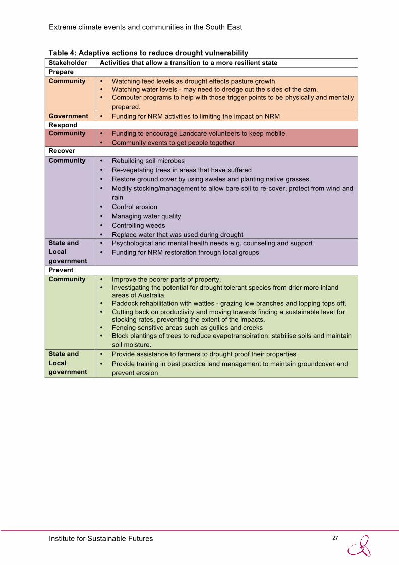
4.1.2 DROUGHT
The impacts of drought on the community and NRM were discussed in three landscapes: Boorowa-Yass and Crookwell-Goulburn landscapes on the Southern Tablelands and in the Cooma-Monaro landscape. The hazard map (Figure 9) indicates that exposure to drought is high throughout these regions and very high in selected areas. These regions suffer from a combination of relatively variable and unpredictable rainfall patterns and large areas of shallow, sedimentary soils predisposing them to drought. The largely agriculture-based economy in these towns means that the community is greatly impacted by this type of extreme event.
Figure 9: Drought hazard map for the SE Region
Prepare
The Prepare phase for drought was likened to “a train crash you see coming for a period before it hits”. Landholders in all three areas reported monitoring the Bureau of Meteorology (BOM) forecasts of the Southern Oscillation Index and El Nino warnings. However, as with bushfire, they felt that the value of the warnings was diminished by their inaccuracy; that is, the number of times the BoM predicts a high likelihood of El Nino that fails to eventuate. Instead landholders monitor subtle signs within the local landscape such as feed levels, pasture and plant growth and water levels in creeks and dams. For larger-scale farms on the Tablelands in particular, landholders reported using a general heuristic (or rule of thumb) for drought preparation, with failed autumn rain as the initial warning, followed by failed spring rain which indicates the onset of drought:
‘When the spring rains failed last year, farmers started preparing for drought’.

24 Institute for Sustainable Futures
Extreme climate events and communities in the South East
Participants agreed that ‘you have to be prepared at all times to respond to drought’, and that there is ‘nothing lost’ in undertaking preparations. Drought preparations were considered good management practice in an ‘unpredictable climate’. Preparation activities focus on the capture, retention and distribution of water in the landscape via landscape based water harvesting, dam and weir maintenance, reticulating and recycling (particularly on smaller-scale properties) water to draw on in drought. Monitoring and maintaining groundcover is seen as critically important to prevent erosion. Landholders plant perennial grasses, swales and deep-rooted trees to improve retention and access to soil moisture.
Respond
Unlike bushfire, there is often little clear distinction between Prepare and Respond phases for drought. The slow but progressive onset of drought makes it difficult for people to realise they are in the Respond phase:
‘By the time you realise, you are already in a drought’. The Respond phase is evidenced by ongoing deficit of rainfall, particularly during periods of high evaporative demand, loss of surface water, a lack of pasture growth and vegetation die back. The adaptive responses are highly localised as landholders review their situation in terms of water reserves, livestock numbers, availability and cost of feed and their financial situation. Drought has a severe impact upon animals through reduced access to pastures, loss of condition and increased likelihood of disease. Landholders weigh up the potential damage of stock management actions on natural resources such as the pasture base and soil condition. Landholders reported the widespread adoption of practices such as ‘sacrificial paddocks’ (paddocks reserved for high-intensity grazing) and drought feed lots, as well as constant adjustment of stock numbers using computer software-based management tools, if available. They also use drought as an opportunity to remove accumulated sediment from dams to increase their capacity while they are dry and to repair fencing. Drought also affects biodiversity through reduced habitat availability and quality e.g. paddock trees often have hollows for arboreal animals but these trees are susceptible to die back during drought. Erosion and dust storms can also reduce water quality and low water levels negatively impact on aquatic biodiversity.
Unlike other extreme climate events, drought fails to attract an emergency management response. This is most likely because of the spatial variation in onset, the slow progression from Prepare to Respond and the often vast scale of the disaster. Landcare groups can act to mobilise volunteers for NRM; however, landholders reported a decline in Landcare membership during drought because people become more focused on the management of their own property rather than undertaking NRM action on public land (smaller-scale landholders). Would-be volunteers become time poor because of the additional burdens of hand-feeding stock (larger-scale landholders) stock transport and sales. Hand feeding is increasingly difficult for an ageing farm population, often comprising single owner-managers on large properties. Long-term droughts can contribute to the erosion of local NRM skills and knowledge, which would normally be mediated through social networks. The NSW Department of Primary Industry and SE Local Land Services were identified as contributing to community cohesion and resilience in the Crookwell/ Goulburn area. While Government may declare an area as drought affected this may not trigger support, as the duration of the response phase is unpredictable.
The decline in social networks during drought can exacerbate feelings of isolation for people on rural properties. As a consequence landholders socialise less frequently as the drought progresses - often at a time when they are most in need of support. Landholders reported that those most in

25 Institute for Sustainable Futures
Extreme climate events and communities in the South East
need were often likely to be isolated before the drought, and therefore even less likely to seek any social assistance or counselling services. Unlike bushfire, where communities come together to ‘fight’ and organisations such as the RFS provide a social focus around action, drought erodes family and community structures. Drought-induced suicides among landholders are disproportionately common, having a huge impact on both families and the wider community. Communities do attempt to alleviate the isolation through social events such as drought buster parties (‘a reason to have a drink when there’s no reason’). Participants emphasised the need to have well and alert farmers able to act on signs of recovery. Community mental health was considered a largely hidden aspect of extreme droughts and a depressed community was thought to be much slower to act and less innovative in response and recovery.
Extensive grazing is the major agricultural activity in the Southern Tablelands and Alpine regions of the South East. Declining terms of trade have severely eroded the profitability of grazing enterprises, particularly on more marginal land. One Alpine grazier explained: ”I’m running out of corners to cut”. Drought further reduces landholders’ financial capital and can leave them with a burden of debt that remains long after the drought has ended. This in turn means that landholders are unable to afford to finance prevention measures. There is reportedly a lack of funding for NRM activities for limiting the impact of drought and when drought assistance is provided it is often ‘too little too late’. Where funding is available, applications have to be very detailed in order to justify a grant, requiring extensive administration, monitoring and very-technical reporting. This is often beyond the capabilities of volunteer organisations or single landholders already experiencing stress, and many are discouraged by the conditions or lack the time or expertise to submit a funding application.
Recover
As with bushfire, the biophysical, financial and psychological aspects of communities recover at different rates. Some participants noted that recovery starts when you ‘get good pasture growth, not just good rain’ (biophysical) but others said that recovery does not begin until stock levels have returned (financial) and the communities have recovered from the shock (psychological). Depending on the extent of the drought, recovery can proceed for several years rather than months, and some communities undergo permanent changes from which they never ‘recover’. Some Alpine graziers believed that they did not recover fully from the 1982 drought, because it marked a step-decline in rainfall that permanently lowered productivity. While returning stock to paddocks is a matter of urgency for financial recovery this is often difficult because stock prices are high during recovery. Landholders believed that the South East’s unpredictable climate means that there is not really a well-defined recovery phase:
‘It’s more of a respite from the next drought than a recovery. You cannot be confident you are in a recovery phase’.
A bank of moisture in the soil can provide some confidence that the drought is ending but loss of vegetation cover results in poor rainfall retention, infiltration and high levels of run-off. Erosion is a problem in the Recover phase and is worsened by past clearing of native vegetation, poor agricultural management practices unsuited to the region’s soils and overstocking. Invasion by new species of weeds can be problematic as the lack of ground cover provides little competition for species introduced through imported feed or purchased replacement stock.
Smaller landholders reported maintenance of ground-cover through composting, re-seeding paddocks with legumes, encouragement of native perennial grasses and planting fodder such as lucerne. Both large and small-scale landholders reduce erosion through improved grazing

26 Institute for Sustainable Futures
Extreme climate events and communities in the South East
management and fencing of riparian and woodland zones from livestock. They recognised the importance of allowing bare soil to re-cover, providing protection from wind and rain.
Recurring drought is reportedly influencing the range of some native animal species. For example, landholders observed higher numbers of wombats in areas not previously observed. Workshop participants feared permanent changes to the region’s ecosystems as a result of frequent drought and agreed on the need for a more holistic view of landscape management that considers native flora and fauna. They suggested practical actions such as building greater connectivity between reserve areas via corridors to help biodiversity adapt to a changing climate.
Prevent
As with bushfire, the activities undertaken to protect NRM in the Prepare and Prevent phases are similar. Landholders focus on trying to ‘drought proof’ properties by planting trees to form windbreaks, and block plantings of native drought resistant species and deep-rooted perennials. Some landholders have trialed plantings of tree-fodder species (such as Tagasaste or ‘tree lucerne’) but were unable as yet to report on its efficacy as drought fodder (however, one grazier emphasised that you would need a lot of tree lucerne to provide anything more than a minor supplement to forage supply in a drought).
While landholders reported being more mindful of the potential for drought in their region and had adopted adaptive management strategies to deal with uncertainty, they agreed that other regions, particularly to the west suffered the effects of drought to a greater extent. Even during drought the region often benefits from the ‘tail end’ of East Coast Lows, which bring severe storms to coastal regions but also deliver rain up onto the escarpment. Graziers believed that except in very severe droughts they were seldom forced to completely destock, being able to retain some level of production during dry periods. Several landholders reported corporate entities (either large corporations or larger partnerships within local families) as consolidating agricultural holdings on the most productive (basalt) soils.
Retaining water in the landscape is an important way to reduce exposure to the impacts of drought. Participants noted that direct drilling can improve the condition of soils and reduce land degradation by avoiding the compaction associated with repeated passes of heavy machinery whilst contour farming was also considered. Soil condition and ground cover can also be maintained by sound rotational grazing management, although in some areas changes in property ownership, an influx of absentee landholders and smaller-scale holdings often see farms over-stocked by inexperienced landholders. Fencing sensitive areas such as gullies and creeks to prevent disturbance by cattle was also seen as an important way to protect riparian zones. Most landholders adopted reticulation and troughs to supply water to livestock, but agreed that this environmental improvement came at the cost of extra infrastructure, monitoring and maintenance of water points. Landholders also reported controlling willows and planting natives such as Eucalyptus viminalis (manna gum) along river banks.
27 Institute for Sustainable Futures
Extreme climate events and communities in the South East
Table 4: Adaptive actions to reduce drought vulnerability Stakeholder Activities that allow a transition to a more resilient state Prepare Community • Watching feed levels as drought effects pasture growth.
• Watching water levels - may need to dredge out the sides of the dam. • Computer programs to help with those trigger points to be physically and mentally
prepared. Government • Funding for NRM activities to limiting the impact on NRM Respond Community • Funding to encourage Landcare volunteers to keep mobile
• Community events to get people together Recover Community • Rebuilding soil microbes
• Re-vegetating trees in areas that have suffered • Restore ground cover by using swales and planting native grasses. • Modify stocking/management to allow bare soil to re-cover, protect from wind and
rain • Control erosion • Managing water quality • Controlling weeds • Replace water that was used during drought
State and Local government
• Psychological and mental health needs e.g. counseling and support • Funding for NRM restoration through local groups
Prevent Community • Improve the poorer parts of property.
• Investigating the potential for drought tolerant species from drier more inland areas of Australia.
• Paddock rehabilitation with wattles - grazing low branches and lopping tops off. • Cutting back on productivity and moving towards finding a sustainable level for
stocking rates, preventing the extent of the impacts. • Fencing sensitive areas such as gullies and creeks • Block plantings of trees to reduce evapotranspiration, stabilise soils and maintain
soil moisture. State and Local government
• Provide assistance to farmers to drought proof their properties • Provide training in best practice land management to maintain groundcover and
prevent erosion

28 Institute for Sustainable Futures
Extreme climate events and communities in the South East
4.1.3 STORMS AND FLOOD
Storms and flooding were discussed at one workshop at Kiama in the Illawarra-Shoalhaven landscape. Storms resulting from the formation of intense East Coast Low (ECL) pressure systems are one of the most damaging weather events for the entire South East coast of NSW. ECL often intensify rapidly overnight and their relatively weak pattern of occurrence, primarily in autumn and winter, means that coastal residents receive little warning from the Bureau of Meteorology (BOM). The hazard map (Figure 10) indicates that susceptibility to flooding occurs in discrete locations that coincide with coastal river catchments (and urban settlements) along the coast but that the Illawarra-Shoalhaven is particularly exposed. A combination of a narrow coastal plain and many short river catchments amplify the impacts of sea level rise, storm surges, flooding and subsidence on human populations and high value infrastructure. In addition, the SE Region has numerous shallow coastal lakes and estuaries (including swamps and salt marshes) that are important threatened ecosystems. The lakes are exposed to the risk of sediment deposition which limits flushing and replenishment leading to stagnation and eutrophication. The Kiama area experienced a major storm in 2011 that resulted in localised flooding.

29 Institute for Sustainable Futures
Extreme climate events and communities in the South East
Figure 10: Flood hazard map for the SE Region. (The intensity of blue shading represents greatest flood hazard)
In contrast with drought but in common with bushfire, storm and flood events have well defined stages. Storms generally have a very rapid onset (i.e. short prepare phase) followed by a relatively short duration (or response phase) due to the relatively rapid rise and fall of flood waters in short coastal catchments. However, as with the other extreme climate events the damage caused can result in a prolonged recovery phase. The State Emergency Service is the combat agency tasked with coordinating the response to storms and flood.
Prepare
Of the three types of events examined in workshops storms appear to have the least well-developed Prepare phase. In general, little action is undertaken by the community in the Prepare phase to reduce threats of storms because of the unpredictable nature of ECLs with very short (often only hours) advanced warning and, unlike bushfire, the lack of a defined ‘storm season’. As a result, the community is frequently unprepared. There is no

30 Institute for Sustainable Futures
Extreme climate events and communities in the South East
institutionally-supported planning process in place to deal with East Cost Lows in same way as the RFS supports household fire plans for bushfire events. Lack of preparation has consequences for protecting life and property and for the management of natural resources.
Given the limited potential for action in the Prepare phase, awareness-raising to promote ‘storm readiness’ needs to shift to prevention throughout the year - not just when the threat of storm or flood is imminent. Workshop participants agreed on the need for a ‘household storm plan’ (similar to a fire plan) that outlines how to mitigate risks for personal safety and assets to reduce damage to life and property as well as natural resources. For example, during storms unsecured gas bottles (from caravan parks), chemical drums (from rural properties) and other buoyant debris are dislodged and move with the flow of flood water. These materials end up in waterways and are often deposited in inaccessible areas of estuaries, wetlands and swamps where they become a long-term litter problem adding to pollution. Planning for ‘storm readiness’ should encourage behavior in the community that prevents these potentially hazardous materials from entering the environment. Workshop participants also indicated that lack of community education about safe evacuation zones in the event of flooding needs to be addressed. As with bushfire, the issue of a lack of local knowledge is worsened by the coincidence of storms with high levels of seasonal tourism. Participants referred to ‘tree hysteria’ among local residents following wind events, which results in widespread calls for trees to be cut down with little or no thought to tree preservation or environmental impact. The localised nature of storms can result in long intervals between major flood events, which present a major challenge to overcoming inertia and loss of knowledge in the community.
Respond
As with other extreme events there is inadequate consideration of NRM in the Respond phase for storms and flood. The SES is the primary response agency and their focus includes coordinating other combat and support agencies, sandbagging to control inundation, securing storm damaged properties, keeping evacuation routes open and assisting in the evacuation of the community. Workshop participants agreed that natural resource management is rarely considered during the response phase and that actions to manage the event can cause unintended consequences for the environment. For example, riparian areas subject to inundation are often managed with heavy earth moving machinery such as bulldozers to control bank stability. Little consideration is given in these operations to their impact on river and lake water quality and loss of top-soil and seed banks. Beaches are routinely used to collect and fill sand bags for flood control. There is some uncertainty around the legality of this action and there is currently no guidance for SES workers on the most appropriate location for sand collection.
The severity of the storm event reportedly modifies the ability of the SES to respond. Very severe storms can make it unsafe for the SES to send out emergency response crews, leaving the community particularly exposed to the likelihood of disruption of essential services such as power, water and telecommunications. Participants identified a lack of clarity around the processes of communication during storm events. Calls to local council regarding problems with trees are reportedly transferred to council’s tree management office. Unlike the SES, these staff may not be trained in dealing with emergency management situations. Participants noted that calls to Sydney Water resulted in a ‘pretty good’ response:
‘They come out to the site and tell you who is responsible for rectifying the issue’.
31 Institute for Sustainable Futures
Extreme climate events and communities in the South East
Recover In common with other types of extreme events, recovery for the community can be slow and support is often withdrawn before economic and social recovery is complete. Flood waters can remain in low lying areas for long periods. There can be an extended period of ‘make-safe’ where flooded properties require inspection to ensure electrical hazards have been addressed before residents are allowed to return to begin the clean-up process.
For NRM, much of the work undertaken by NRM groups such as Landcare with government grant funding can be damaged or lost during floods. Despite the high risk of loss of restoration works in riparian areas, there is no provision of funding to replace riparian remediation works following a flood event. Landcare volunteers at the workshop indicated that replacement of storm-damaged NRM works would require a new funding application, with no guarantee of success, which can be disheartening for NRM volunteers. In addition, action to clear waterways and coastal lakes of sediments involving dredging can impact the fragile estuary environments.
Prevent
Workshop participants recognised that flood prevention was a whole-of-catchment issue. Land use change in the upper catchment affects flood risk in the lower catchment. The Kiama region has a limited floodplain and the cumulative impact of urban development increases impervious areas with dramatic effects on the volume and velocity of surface runoff, exposing areas to the risk of erosion and flash flooding. For coastal areas subject to beach erosion and storm surges, participants feared that the natural coastal protection features, such as dune systems and the vegetation they support are being damaged through residential development. Aside from the significant loss of these endangered ecosystems, the damage to ‘bio-protection’ buffering increases the exposure of beach-side dwellings to storm impacts. There is a need to spatially identify areas exposed to the impact of storms and flooding in order to ensure that future developments consider the increased risk of extreme ECL events.
Riparian restoration is a focus of NRM actions in coastal catchments to prevent stream bank erosion. However, workshop participants identified some NRM actions in riparian zones as producing downstream consequences in floods. In particular, the materials such as weed matting or bamboo canes used to assist re-vegetation efforts are often washed downstream, adding to pollution in estuaries.
Participants felt that planning for storms in coastal catchments needs to become a normal part of community preparedness for extreme events. In particular, the community needs to become much more aware of the role of ecosystem services in coastal protection. The current mindset appears to allow degradation to occur, then replace green infrastructure with inadequate (non-adaptive) engineered structures, which are prone to failure and can be more costly than green infrastructure.

32 Institute for Sustainable Futures
Extreme climate events and communities in the South East
Table 5: Adaptive actions to deal with storms and flooding Stakeholder Activities that allow a transition to a more resilient state Prepare Community • Fencing off riparian areas to protect/rehabilitate
• Move assets if possible for example cars/ caravans Emergency Management
• Reduce impacts such as cleaning and checking storm water drains. • Better notification of coming events to the community including social
media, warnings etc. • Prepare equipment including distribution and filling of sand bags before an
event Local and State Government
• A storm education programme – listing what people should do to secure assets and safe behaviors
• Funding for NRM activities to limiting the impact on NRM • Upgrading of communication and IT infrastructure as bandwidth insufficient
to deal with an emergency event • Increase funding for volunteer organisations - Participants noted that there
is a lack of local volunteers in Milton and Ulladulla. • Targeted information included in rates notices, community circulars about
being storm ready • Community education campaign to inform people of places to go for refuge
and what to do in case of a flood. Respond Government • Support SES in their efforts to manage the event
• Support agencies such as the RSPCA rescue livestock or wild animals that have been affected by flooding
Community • Community events to get people together • Inform community of appropriate actions if an event occurs - refuge centres
– behaviour and preparation including supplies / clean water / medical equipment
• Distribution of information sheets (what to do when something happens)
Recover Community • Re-vegetating trees that have suffered
• Control erosion • Managing water quality • Control weeds
State and Local government
• Psychological and mental health needs e.g counseling and support • Funding for NRM restoration through local groups • Support landholders and wildlife agencies to rescue and rehabilitate
animals Prevent Community • Fencing sensitive areas such as gullies and creeks
• Block plantings of trees to stabilise soils and prevent run-off. • Ensure that gutters are well maintained and free of derbris.
State and Local government
• Review the location of critical infrastructure that is particularly exposed in low-lying areas; e.g. roads and rail built along side or close to the ocean are constantly being upgraded but can easily be lost.

33 Institute for Sustainable Futures
Extreme climate events and communities in the South East
• Flexible land use required in the hazard zone. • Identify natural areas exposed to storms and flooding. Prevent future
development to maintain buffers. • Channel water toward parks and reserves where water can be absorbed
into the soils to reduce run-off. • Consider the impact of any mitigation works within sensitive areas such as
sand dunes
34 Institute for Sustainable Futures
Extreme climate events and communities in the South East
5 DISCUSSION We draw five main conclusions from the analysis of these workshops:
1. The PPRR emergency management cycle is a useful concept to engage rural and regional communities in the generic responses to extreme climate events including the roles of government combat and support agencies and NGO social services. It also helps to identify the responsibilities of local communities for ensuring their own readiness for extreme events.
2. In practice, variations among the types of extreme events, the hazards within specific landscapes and the capacity of discrete communities within the South East most often means that the PPRR cycle does not accord with the lived experience of a community. This is most obvious during the recovery phase of the cycle for all event types, for rural communities and in drought, as this event fails to trigger a typical emergency response.
3. Despite the intrinsic value of natural resources in supporting rural and regional communities, natural resources are seldom explicitly considered in the management of extreme events, particularly in Respond, which is necessarily concentrated on the protection of property and life during an event. This approach may have unintended and long-term consequences for preservation of the natural resource base in other phases of the cycle. The response of rural landholders to drought may be the exception, where graziers in the Alpine and Tablelands landscapes have adopted practices to protect pasture cover and soil resources.
4. The key to improved management of natural resources for extreme events appears to lie in Prepare and Prevent phases of the cycle. It is likely that new partnerships will be required between EM services, local government, regional-based State agencies (such as LLS) and rural and regional communities.
5. The management of drought requires a significantly different response to other extreme climate events. Unlike bushfire and flood, which encourage collective action in communities against a visible threat, drought acts slowly to isolate the most vulnerable community members, destroy rural families and erode the social capital of affected communities of SE NSW.
What defines an extreme climate event?
One of the major concerns with a potential change in climate is that an increase in extreme events will occur. Surprisingly, there have been limited attempts to define extreme events in practical terms, most likely because of a shifting baseline to measure against. Taleb’s (2007) discussion of Black Swan events emphasises society’s blindness with respect to randomness, particularly in relation to large deviations. In keeping with Taleb, Hoover et al. (2011) defines an extreme event for ecological systems as an occurrence “that is statistically rare or unusual climate period alters ecosystem structure and or function well outside the bounds of what is considered typical or normal variability”. Easterling et al. (2000) categorises climate extremes into two broad groups: (i) those based on simple climate statistics, which include extremes such as heavy daily or monthly rainfall volumes or very low or very high daily temperatures, that occur annually, and (ii) more complex event-driven extremes, examples of which include severe drought, storm, floods, which do not necessarily occur every year at a given location. For drought, more nuanced definitions have been formulated. Hennessey et al. (2008) identify four types of drought: meteorological drought (a period of low rainfall); agricultural drought (short-term dryness of soil at a critical time in the growing season); hydrological drought (prolonged moisture deficits that affect surface or sub-surface water supply, thereby reducing stream flow, groundwater, dam and lake levels); and socio-economic drought (when human activities are affected by meteorological, agricultural or

35 Institute for Sustainable Futures
Extreme climate events and communities in the South East
hydrological drought). A number of types of events were discussed in workshops and participants recognised scale-dependent differences in community behavior around the PPRR cycle.
An extreme event timeline
To frame a discussion of extreme events in the context of improved protection of natural resources that span multiple types of events in multiple regions by multiple actors we propose a theoretical extreme event time line (Figure 11). The timeline illustrates the level of activity that occurs in each phase of the PPRR cycle. It draws on general information elicited through the workshop process and seeks to show how the different types of extreme events can vary from the theoretical, and where the current short comings in the use of the PPRR cycle lie from the dual perspectives of the community and of natural resource management.
Figure 12: Theoretical extreme event timeline
The actions of the large number of emergency response actors have been grouped into 3 separate timelines: government EM agencies under emergency management activity, NGOs involved in community support under social assistance activity; and, community members not directly involved in volunteer EM services under community activity. An additional timeline seeks to illustrate the impact of an extreme event on ecosystem service provision under natural resource function. Activity ranges across a generic scale from low to high for EM actors and from impaired to repaired for NR function.
For emergency service actors, activity increases throughout Prepare, plateaus at a high level during Response and remains high through the ‘make-safe’ period early in Recover. Activity then

36 Institute for Sustainable Futures
Extreme climate events and communities in the South East
declines through the remainder of Recover to stabilise at a lower level throughout Prevent. For social assistance actors, activity increases rapidly during early Respond stimulated by the availability of government disaster funding to provide emergency food, clothing and shelter for evacuees. This type of social assistance remains high throughout Respond and declines during Recover as people are able to return to their homes after the ‘make-safe’ period. A second type of social assistance that provides financial and psychological counseling for disaster victims (and emergency service volunteers) increases during Respond and peaks during Recover. These services decline sharply as government funding is withdrawn at the end of Recover. For the community, activity rises sharply in response to imminent danger and marks the change from Prepare to Respond. It then remains relatively high except for a hiatus in activity at the change from Respond to Recover as evacuees are unable to begin clean-up activities while emergency service personnel operate in the ‘make-safe’ period. Community activity then declines through Recover as ‘normal’ life is resumed and stays at a relatively low level during Prevent. Natural resource function declines sharply with the onset of the extreme event, remains impaired during Respond and may rise with the re-establishment of ecosystem services during Recover. The severity of the event determines the depth and duration of impairment. Ideally the level of emergency management and community activities in Prevent and Prepare would be sufficient to ensure protection of the natural resource base during the event and complete repair of natural resource function during Recover. It should be noted that none of the event types examined in workshops conforms to the theoretical timeline.
Effectiveness of the PPRR cycle
The duration of each phase of the cycle from the community’s perspective will depend on the type of extreme event. For drought the Prepare phase progresses slowly merging into Respond and results in a gradual deterioration of natural resource function that underpins economic activity, with flow on effects to community social cohesion as the drought continues. For bushfire the threat is regular and seasonal but the high risk period is being extended so that Prepare and Prevent phases are becoming less well defined. Community interest tends to wane through the need for a constant state of readiness. Storms are unpredictable and of limited duration so Prepare and Respond phases are correspondingly short allowing little opportunity for community action.
The combined duration of Recover, Prevent and Prepare phases is equivalent to the interval between single events. This interval varies with the type of event and, for some events, is also influenced by natural resource function. For example the incidence of major bushfires is dependent on weather conditions and fuel load. Fuel load is removed by fire (either an event or a hazard reduction burn) providing a period of respite between events while vegetation recovers. Droughts tend to occur in clusters following ocean temperature cycles (measured as the Indian Ocean Dipole and the La Nina/El Nino systems) punctuated with periods of wetter conditions. Storm events, which can lead to flooding, however, could occur in close succession. There is also the increasing potential for multiple events to occur consecutively: drought leading to higher incidence of bushfires followed by intense rain and flooding, which further blurs the phases of the EM cycle.
The significance of Recover
Recovery, or the ability to bounce back from shocks is central to theories of social ecological resilience (Walker and Salt 2006). However, the Recover phase of the PPRR cycle is the most complex, hardest to manage and, in many ways, most critical phase of the cycle. The often protracted nature of recovery and its reliance on local context make it difficult for centralised responses from government. The speed of recovery varies across economic, social and environmental components of social-ecological systems. While economic recovery can be slow, it

37 Institute for Sustainable Futures
Extreme climate events and communities in the South East
is supported through rebuilding of private assets with insurance payouts and essential public infrastructure through government disaster funding. Social impacts of extreme events, particularly those of mental health, are becoming recognised as increasingly important if not always fully addressed (Fritze et al 2008). Recovery from bush fires generates high public interest and is often a focus of media attention because they are of relatively short duration and provide moving images (e.g. media coverage of the anniversary of the 2013 Blue Mountains fire event). While drought generates sympathy in urban communities, its longer duration can result in media fatigue and waning public interest (Leitch and Bohensky 2014). It was clear from workshops that community workers believed that government social assistance for extreme events is withdrawn well before many members of the community recover.
The concept of ‘normalisation’ to climate change and extreme events to build community resilience and self-reliance is becoming central to government disaster planning. Extreme events often accelerate autonomous adjustment processes that are ongoing in regional areas. However, long term or catastrophic events can overwhelm a community’s coping ability leaving it unable to recover without external assistance. Various alternative models of government support under drought have been proposed (e.g. Nelson et al 2008; Nelson and Finan 2009). Landholders that participated in the drought workshops understood and accepted short-term dry periods (1-2 years) as part of the agricultural production environment in SE NSW. They generally agreed that land managers should be expected to plan for such regular events. However, their ability to set aside sufficient reserves to manage for severe droughts (such as the Millennium Drought from 2002-2007) appears beyond their capability. That coping strategies are being already overwhelmed is evident in the high incidence of rural family breakdown, farmer suicides and rapid demographic/land-use change in the SE. The wisdom of a government policy stance for extreme events in rural and regional communities that relies heavily on building and maintaining local community resilience is questionable in the knowledge community coping will be exceeded in the future. It may be necessary to facilitate local transformation in order to preserve regional resilience (Walker et al 2009, Bardsley 2014).
Rates of recovery also depend on the re-establishment of ecosystem service provision particularly for natural resource dependent livelihoods (such as agriculture and tourism). For the SE Region, grazing enterprises, which are the dominant form of agricultural production, are particularly hard hit because recovery depends not only on plant growth rates (pasture availability) but also on having sufficient stock numbers to harvest available pasture mass. Stock numbers depend in turn on breeding rates and or ability to purchase suitable animals (usually unavailable because of high prices following widespread drought). There is already considerable autonomous adaptation occurring in response to a range of drivers including variable rainfall. These adaptations include changed practices (drought feedlots, adaptively managed stocking rates), changed land-use (both fragmentation of ‘unviable’ farms and consolidation of agriculture on basalt soils) and a shift to other livelihood options (reliance on off-farm employment, non-resident ownership). Further change along some of these pathways may be limited. For example amalgamation of properties to achieve economies of scale at low stocking rates are limited by labour availability. It is likely that socioeconomic tipping points will be exceeded with only small future changes to production environments (such as further declining terms-of-trade, e.g. Bell et al. 2014) coupled with increased intensity or frequency of extreme climate events.
Vulnerability in the South East
A number of issues were identified that contribute, often indirectly, to increasing the vulnerability of the SE region to extreme events. These issues were also identified through a region wide

38 Institute for Sustainable Futures
Extreme climate events and communities in the South East
assessment of vulnerability of government service provision to climate change conducted by OEH (Jacobs et al 2014).
Population change
In coastal areas, the high transient tourist population and the large number of new residents moving into the South East regional makes it challenging to reduce extreme event risks. Non-resident landowners are often difficult to engage in managing natural resources. Many visitors or newcomers to the area have not experienced a major event and do not fully understand the process of response and may have expectations of services that are unable to be met. The long time lag between major events (e.g. bushfire on the South Coast) presents a major challenge for EM agencies as they need to overcome community apathy and a loss of local knowledge.
Infrastructure vulnerability
Limited transport access routes, in particular on the coast, and patchy communication services can increase isolation and increase vulnerability to extreme events. The region is heavily dependent on privately owned road transport with no rail service to the coast, a single airport and no major shipping transport. Extreme event management is increasingly reliant on dissemination of information to the community via mobile communications, the internet and social media. Communications can be lost during bad weather and components of the communication system (such as mobile towers) are exposed to the risk of bushfire.
Rural change and social capital
Many areas of the SE Region are undergoing significant land-use change, with a shift towards fragmentation of larger agricultural holdings (more hobby farms and lifestyle blocks and smaller-scale agriculture) and non-resident landholders (e.g. Tonts and Grieve 2002). This change has resulted in an influx of people to the community that does not have a rural background and lacks both knowledge and experience with NRM in general. Participants identified the need for better education about NRM for ‘blockies’ and absentee landholders especially around practices that make the area more vulnerable to the impact of extreme events such as loss of ground cover, dirt-bike riding and lighting bonfires as well as better education about the role of wildlife in the landscape. In addition, change in rural populations coupled with an aging population of farm managers can reduce the level of volunteerism in organisations such as the RFS and SES. The ability to attract and retain a new generation of younger volunteers is being addressed and there is a need to ensure that older volunteers can still participate in the coordination efforts if they are unable to be involved directly in responding to extreme events.
Improvements to the theoretical extreme event timeline In Section 5 we collate the specific recommendations from workshop participants for improvements to the management of natural resources for extreme events. However, in Figure 13 we propose some changes to the hypothetical extreme event time line (Figure 12) to improve the management of natural resources. These changes are a synthesis of information from all of the workshops and do not relate specifically to one type of event or individual landscape. Improvements to the individual activity lines are shown in black.

39 Institute for Sustainable Futures
Extreme climate events and communities in the South East
Figure 13: Improved theoretical extreme event timeline.
Actions to better protect the natural resource base are unlikely to occur during Respond, where protection of lives and property will remain the priority and under the control of emergency management combat agencies, especially for large scale events. Instead, protection of NRM for extreme events should focus more attention in the Prevent phase. This could occur in three ways:
1. Increased activity by emergency management combat agencies to advise and support communities, particularly rural landholders, to sensibly manage vegetation on private land so that over-clearing and ‘tree hysteria’ is limited. The information required to undertake such additional activity may require greater co-operation among combat and support agencies (such as LLS, OEH) to formulate local guidance material.
2. Increased social assistance from government that specifically-targets the restoration and maintenance of living green infrastructure, particularly where it has been damaged by recent extreme events and is essential to the ongoing protection of communities (such as dune systems in coastal regions). Such a scheme could be administered by LLS in collaboration with other government agencies.
3. Increased community activity to protect natural resource-dependent livelihoods, which includes action on both public and private land. The availability of social assistance funding for natural resource restoration could be used as a catalyst for this activity which would not only protect ecosystem services but raise awareness in the community of extreme event preparedness in both Prevent and Prepare phases.
These three changes should reduce the level of impairment of natural resource function during the Respond phase. The form that these additional activities should take needs to be negotiated at LLS landscape scale and be informed by local understanding of the most significant extreme event hazard (e.g. Hammill and Tasker 2010 for bush fire).

40 Institute for Sustainable Futures
Extreme climate events and communities in the South East
6 RECOMMENDATIONS The findings from this report have been used to develop a series of twenty-five recommendations for various government agencies. Eleven recommendations have been formulated for the South East Local Lands Service and a further fourteen recommendations for other Government agencies such as Department of Primary Industries (DPI) National Parks and Wildlife Service (NP&WS), Local Government, Rural Fire Service (RFS), State Emergency Service (SES), District Emergency Management Committee (DEMC) and the Local Emergency Management Committee (LEMC).
6.1 Recommendations for the South East Local Land Services 1. Provide support to combat agencies on NRM issues. LLS could develop targeted training to
facilitate knowledge transfer by organising annual or bi-annual workshops for RFS, SES and Local Emergency Management Committee (LEMC) for managing natural resources especially in the response and recovery phases.
2. Posters or signage could be developed that convey information about managing NRM for extreme events to raise awareness among the emergency management sector and wider community.
3. Support peer-to-peer learning for the community through workshops and seminars and knowledge sharing by local leaders. Suggested workshop themes include: applying for grants; managing volunteers; managing NRM; environmental monitoring.
4. LLS could increase awareness and action by disseminating best practice guidelines, focussed on managing NRM for extreme events
5. Consolidate LLS services and coordinate to improve the capacity of communities to deal with extreme events through the maintenance and effective, holistic delivery of information and extension services on land management. For drought, LLS could promote best-practice interventions and educational programs to enable better property management planning by incorporating drought management techniques: destocking decision-making time frames and prioritisation of stock.
6. Support and facilitate volunteer programs to assist with restoring remnant vegetation to overcome financial and time constraints that currently limit works to increase landscape resilience. Encourage local government and other land managers to support volunteer programs that build both social and human capital.
7. Increase the assistance that LLS provides to the administration and develop grant applications for externally-funded NRM works - especially in the Recover and Prevent phases.
8. Support the development of a seed bank in conjunction with local councils. Make seeds available to the community to restore / improve grasslands and native ground cover to limit the impacts of erosion post-fire and drought.
9. Develop strong linkages with Aboriginal leaders on how to incorporate aspects of Indigenous landscape management to adapt to a changing climate.
10. Former CMA/NRM staff could accompany former LHPA / biosecurity staff when they go out to inspect properties post-fire. NRM staff can investigate environmental impact, whilst LHPA investigate the impact of fire on livestock.
11. Establish a greater community profile during community events and workshops to showcase the broad spectrum of services offered by LLS.

41 Institute for Sustainable Futures
Extreme climate events and communities in the South East
6.2 Recommendations for Government Agencies (DPI, NP&WS LG, RFS, SES)
12. Facilitate high-level discussion/strategic consideration of NRM by EM services and government agencies to limit the unintended consequences for NRM in the response phase.
13. State and Federal Governments to provide a dedicated stream of natural resource funding especially in the lead up to a drought.
14. Funding for programs that build social capital and cohesion that can also influence mental health to assist in coping with extreme events.
15. Establish a fire inspections service for landholders that is advisory (rather than regulatory) to improve extreme event readiness and reduce hazards in prevention phase.
16. RFS and Local Emergency Management Committee (LEMC) to revise personal fire plans to include more of a focus on Natural Resource Management by including more questions that provide people with a prompt to consider NRM more strongly in fire planning.
17. Ensure that adaptive co-management is institutionalised within agencies to provide support, mutual learning, trust and reciprocity between agency staff and natural resource managers of multi-use landscapes.
18. Local Councils to develop a community campaign that provides locally-relevant information about practical actions to reduce exposure to EE’s that are sensitive to the local environment and what to do/where to go to be safe during a storm/flood or fire event. Information could be disseminated through Council rates notices, community circulars etc.
19. LLS, RFS and SES could co-sponsor a ‘Local Leaders’ development program to build social and human capital in regional communities so that they are better equipped to deal with extreme events.
20. Allocate more funding/resources for education and engagement with the public as well as a mandate to increase all hazard literacy into the school curriculum.
21. Clear documentation and coordination of what agencies preform which services to improve clarity.
22. Local Governments and LLS can encourage greater adoption of landscape wide management, building water sensitive infrastructure and slow water down in the landscape to minimise impacts during a major storm event.
23. Local Governments need to undertake preventative actions periodically to reduce impacts such as cleaning and checking storm water drains so they do not overflow during a storm.
24. Planning needs to take a more holistic view of land management that considers insects, birds and wildlife and suggested practical actions such as building greater connectivity between green spaces, via connectivity ‘corridors’ to help biodiversity adapt to a changing climate.
25. More research to understand the role that the natural environment plays in providing a buffer to reduce the impacts of weather extremes.

42 Institute for Sustainable Futures
Extreme climate events and communities in the South East
7 REFERENCES Bardsley, D. K. Limits to adaptation or a second modernity? Responses to climate change risk in the context of failing socio-ecosystems. Environment, Development and Sustainability, 1-15.
Bosomworth, K and Handmer, J. Climate change and community bushfire resilience. Chapter 16. Community Bushfire Safety. Bushfire CRC (2008).
Bell, Lindsay W., Richard C. Hayes, Keith G. Pembleton, and Cathy M. Waters. Opportunities and challenges in Australian grasslands: pathways to achieve future sustainability and productivity imperatives" Crop and Pasture Science (2014).
Crossman, N. D., & Bryan, B. A. (2009). Identifying cost-effective hotspots for restoring natural capital and enhancing landscape multifunctionality. Ecological Economics, 68(3), 654-668.
Easterling, D, Meehl, G, Parmesan, C, Changnon, S, Karl, T and O Mearns, L (2000). Climate Extremes: Observations, Modeling, and Impacts. Science, Vol. 289 no. 5487 pp. 2068-2074
Fritze, J., Blashki G., Burke, S. and Wiseman, J. (2008) Climate change and the promotion of mental health and wellbeing. International Journal of Mental Health Systems 2008, 2:13
Hammill, K. and Tasker, L. (2010) Vegetation, fire and climate change in the Greater Blue mountains World Heritage Area. Department of Environment, climate Change and Water, Sydney.
Hennessey, K., Fawcett, R., Kironoa, D., Mpelasokaa, F., Jones, D., Bathols, J., et al. (2008). An assessment of the impact of climate change on the nature and frequency of exceptional climatic events. Canberra: Australian Bureau of Rural Sciences, Department of Agriculture, Fisheries and
Hoover, D. L., Knapp, A. K., & Smith, M. D. (2014). Resistance and resilience of a grassland ecosystem to climate extremes. Ecology 95:2646–2656.
Jacobs B, Lee C, O’Toole D, Vines K. Integrated regional vulnerability assessment of government services to climate change. International Journal of Climate Change Strategies and Management; 6:3. 2014.
Kokic, Philip; Davidson, Alistair and Boero Rodriguez, Veronica. Australia's Grains Industry: Factors Influencing Productivity Growth [online]. Australian Commodities: Forecasts and Issues, Vol. 13, No. 4, 2006: 705-712. Availability: <http://search.informit.com.au.ezproxy.lib.uts.edu.au/documentSummary;dn=090065504085170;res=IELAPA> ISSN: 1321-7844. [cited 03 Nov 14].
Leitch, A. M., & Bohensky, E. L. (2014). Return to ‘a new normal’: Discourses of resilience to natural disasters in Australian newspapers 2006–2010. Global Environmental Change, 26, 14-26.
Marshall, N. A., Park, S. E., Adger, W. N., Brown, K., & Howden, S. M. (2012). Transformational capacity and the influence of place and identity. Environmental Research Letters, 7(3), 034022.
Nelson, R., Howden, M., & Smith, M. S. (2008). Using adaptive governance to rethink the way science supports Australian drought policy. Environmental Science & Policy, 11(7), 588-601.
Nelson, D. R., & Finan, T. J. (2009). Praying for drought: persistent vulnerability and the politics of patronage in Ceará, Northeast Brazil. American Anthropologist, 111(3), 302-316.
Richardson, K., Steffen, W. and Liverman, D. eds. (2013) Climate change: Global risks, challenges and decisions. Cambridge University Press.
Rickards, L. and Howden, S.M. (2012) Transformational adaptation: agriculture and climate change. Crop & Pasture Science, 2012, 63, 240–250
Tonts, M., & Greive, S. (2002). Commodification and creative destruction in the Australian rural landscape: the case of Bridgetown, Western Australia. Australian Geographical Studies, 40(1), 58-70.

43 Institute for Sustainable Futures
Extreme climate events and communities in the South East
Walker, B. H., Abel, N., Anderies, J. M., & Ryan, P. (2009). Resilience, adaptability, and transformability in the Goulburn-Broken Catchment, Australia. Ecology and Society, 14(1), 12.
Walker, B. and Salt D. (2006) Resilience thinking: sustaining ecosystems and people in a changing world. Island Press.

44 Institute for Sustainable Futures
Extreme climate events and communities in the South East
8 APPENDIX 1: Agenda for the community workshops:
o A summary of local climate drivers (drawn from the Office of Environment and Heritage’s NSW Climate Profile)
o Hazards faced by communities of the South East using exposure mapping to selected climate events
o Using the Emergency management cycle (PPRR) to explore how it relates to Natural Resource Management (NRM) in regional communities during the plenary session
o Detailed discussion about how the community currently manages natural resources in response to extreme events, where they source information, who they work with, financial support they can access to adapt, what will be lost in the community if extreme events worsen or become more frequently and how they can adapt to conserve natural resources.
9 APPENDIX 2: Each of the eight workshops concluded with participants completing a workshop evaluation form. The results of the evaluation process are contained within the table below and represent the feedback of 80 participants:
Table 6: Cumulative workshop evaluation results