Embed Size (px)
Citation preview
1
NEBRASKA ADMINISTRATIVE CODE
Title 428 - BOARD OF PUBLIC ROADS CLASSIFICATIONS AND STANDARDS
Chapter 2 - Procedures for Standards
Contents ......................................................................................................................................................... Section Page
Table of Contents ........................................................................................................................................... — ...... 1
Minimum Design Standards ........................................................................................................................... 001 .... 3
MINIMUM DESIGN STANDARDS -- PART ONESTATE HIGHWAY SYSTEM
Minimum Design Standards - Rural (Adopted October 26, 2001)New and Reconstructed Rural State Highways ................................................................................. 001.01 ....... 5New and Reconstructed Bridges on New and Reconstructed Rural State Highways ........................ 001.02 ....... 6Resurfacing, Restoration and Rehabilitation (3R) Projects onNon-Interstate Rural State Highways ............................................................................................... 001.03 ....... 7
Scenic - Recreation - Rural State Highways ...................................................................................... 001.04 ....... 8
Typical Cross Section of Improvement for New andReconstructed State Highways (Adopted _____________)Interchange Ramp .............................................................................................................................. 001.05 ....... 9
Typical Cross Sections of Improvements for New andReconstructed Rural State Highways (Adopted October 26, 2001)Design Number DR1 (Crowned) ........................................................................................................ 001.06 ....... 10Design Number DR1 (Tangent) .......................................................................................................... 001.06ADesign Number DR2 (Crowned) ........................................................................................................ 001.07 ....... 11Design Number DR2 (Tangent) .......................................................................................................... 001.07ADesign Number DR3 .......................................................................................................................... 001.08 ....... 12Design Number DR4 .......................................................................................................................... 001.09 ....... 13Design Number DR5 .......................................................................................................................... 001.10 ....... 14Design Number DR6 .......................................................................................................................... 001.11 ....... 15
Minimum Design Standards - Municipal (Adopted October 26, 2001)New and Reconstructed Municipal State Highways ........................................................................... 001.12 ....... 16New and Reconstructed Bridges on Municipal State Highways ........................................................ 001.13 ....... 17Resurfacing, Restoration and Rehabilitation (3R) Projects onNon-Interstate Municipal State Highways ......................................................................................... 001.14 ....... 18
2
Contents ......................................................................................................................................................... Section Page
MINIMUM DESIGN STANDARDS -- PART TWOLOCAL ROADS AND STREETS
Minimum Design Standards (Adopted October 26, 2001)Municipal Streets ................................................................................................................................ 001.15 ....... 19Rural Roads ........................................................................................................................................ 001.16 ....... 20Scenic - Recreation - Rural Roads ..................................................................................................... 001.17 ....... 21
Typical Cross Sections for Rural Roads (Adopted October 26, 2001)Design Number ROA1 ........................................................................................................................ 001.18 ....... 22Design Number ROA2, RC1, RL1 ...................................................................................................... 001.19 ....... 23Design Number ROA3, RC2, RL2 ...................................................................................................... 001.20 ....... 24Design Number ROA4, RC3 .............................................................................................................. 001.21 ....... 25Design Number RL3 ........................................................................................................................... 001.22 ....... 26
Minimum Construction Standards (Adopted September 20, 1974) .................................................................. 002
Minimum Maintenance Standards (Adopted September 16, 1983).................................................................. 003
Relaxation of Standards (Adopted July 19, 1985)............................................................................................ 004
Relaxation of Standards for Scenic - Recreation Roads (Adopted January 16, 1981) .................................... 005
Maintenance Standards for Minimum Maintenance Roads (Adopted July 19, 1985) ...................................... 006
Standard Compliance Inspection Procedures (Adopted March 15, 1974) ....................................................... 007
3
Title 428 - BOARD OF PUBLIC ROADS CLASSIFICATIONS AND STANDARDS
Chapter 2 - Procedures for Standards
001 MINIMUM DESIGN STANDARDS.
Copies of the most current editions of the following documents referred to in the Standards are on file in theNDOR Central Administration Complex, 1500 Highway N-2, Lincoln, Nebraska:
AASHTO “A Policy on Geometric Design of Highways and Streets”AASHTO “A Policy on Design Standards — Interstate System”NDOR “ Nebraska National Highway Functional Classification Map”NDOR “Nebraska State Highway Functional Classification Map”NDOR “State Functional Classification Maps” (Counties and Municipalities)NDOR “Nebraska Interstate and Priority Commercial Systems Map”NDOR “28 ft Top System Map”
The following abbreviations and symbols are used in the Standards:
' foot/feetAASHTO American Association of State Highway and Transportation OfficialsADT Average Daily TrafficBoard Board of Public Roads Classifications and StandardscL centerlineDeg degreeDHV Design Hourly VolumeDiv. dividedFHWA Federal Highway Administrationft foot/feetHL93 AASHTO Load and Resistance Factor Design (LRFD) Bridge Design SpecificationHS15 AASHTO loading requirements for a standard HS15 truckHS20 AASHTO loading requirements for a standard HS20 truckkm kilometerkm/h kilometers per hourLt leftm meterMax. maximumMin. minimummph miles per hourMS13.5 Metric equivalent of HS15 loadingMS18 Metric equivalent of HS20 loadingN/A not applicableNDOR Nebraska Department of RoadsNHS National Highway SystemROW Right of WayRt right% percent

4
5
Title 428 — BOARD OF PUBLIC ROADS CLASSIFICATIONS AND STANDARDS
Chapter 2 — Procedures for Standards (Continued)MINIMUM DESIGN STANDARDS - PART ONE
STATE HIGHWAY SYSTEM
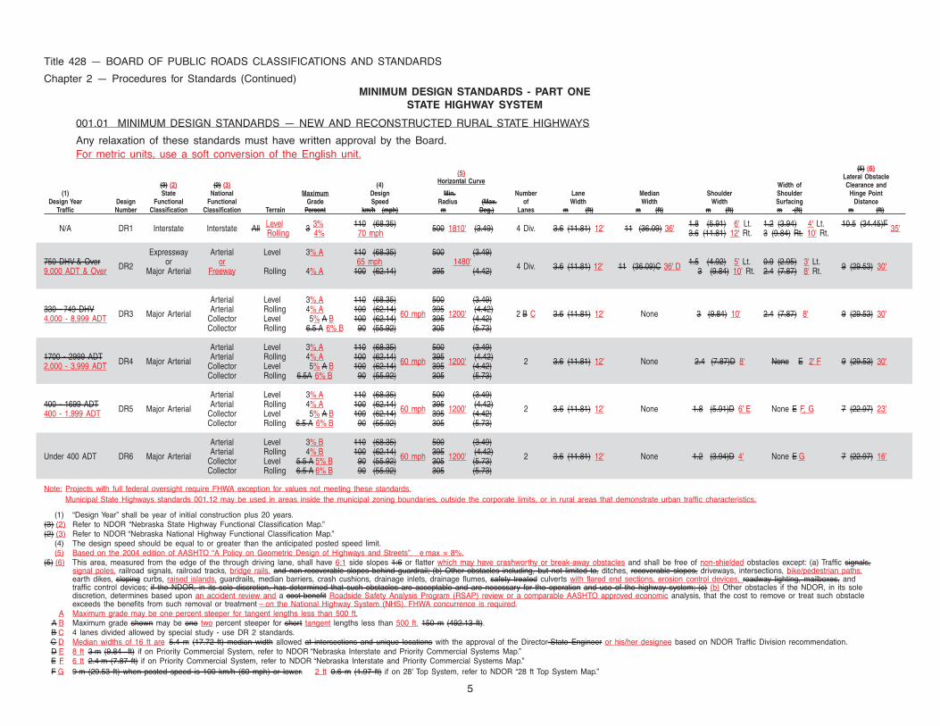
001.01 MINIMUM DESIGN STANDARDS — NEW AND RECONSTRUCTED RURAL STATE HIGHWAYS
Any relaxation of these standards must have written approval by the Board.For metric units, use a soft conversion of the English unit.
(5) (6)(5) Lateral Obstacle
(3) (2) (2) (3) (4) Horizontal Curve Width of Clearance and(1) State National Maximum Design Min.X XXXXX Number Lane Median Shoulder Shoulder Hinge Point
Design Year Design Functional Functional Grade Speed Radius (Max. of Width Width Width Surfacing DistanceTraffic Number Classification Classification Terrain Percent km/h (mph) m Deg.) Lanes m (ft) m (ft) m (ft) m (ft) m (ft)
N/A DR1 Interstate Interstate All Level 3 3% 110 (68.35) 500 1810' (3.49) 4 Div. 3.6 (11.81) 12' 11 (36.09) 36' 1.8 (5.91) 6' Lt. 1.2 (3.94) 4' Lt. 10.5 (34.45)F 35'Rolling 4% 70 mph 3.6 (11.81) 12' Rt. 3 (9.84) Rt. 10' Rt.
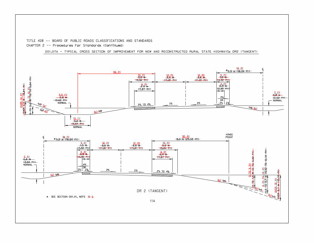
Expressway Arterial Level 3% A 110 (68.35) 500 (3.49)1.5 (4.92) 5' Lt. 0.9 (2.95) 3' Lt.750 DHV & Over DR2 or or 65 mph 1480' 4 Div. 3.6 (11.81) 12' 11 (36.09)C 36' D 3 (9.84) 10' Rt. 2.4 (7.87) 8' Rt. 9 (29.53) 30'9,000 ADT & Over Major Arterial Freeway Rolling 4% A 100 (62.14) 395 (4.42)
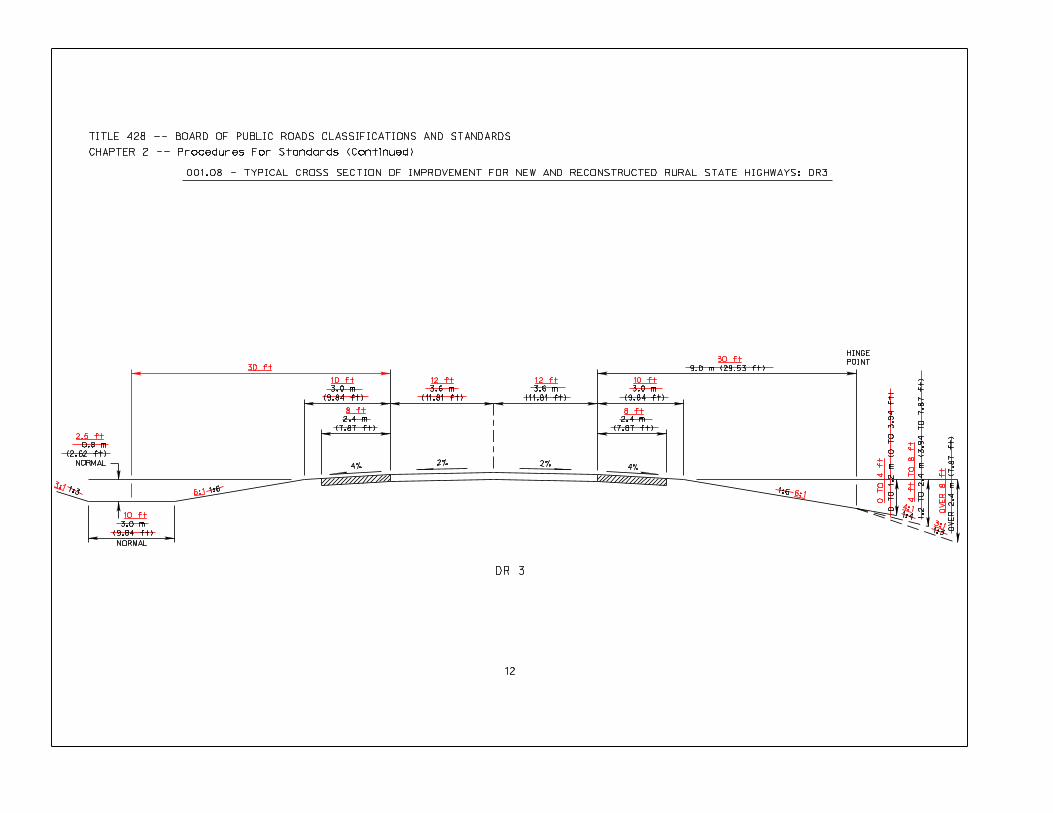
Arterial Level 3% A 110 (68.35) 500 (3.49)330 - 749 DHV DR3 Major Arterial Arterial Rolling 4% A 100 (62.14) 60 mph 395 1200' (4.42) 2 B C 3.6 (11.81) 12' None 3 (9.84) 10' 2.4 (7.87) 8' 9 (29.53) 30'4,000 - 8,999 ADT Collector Level 5% A B 100 (62.14) 395 (4.42)
Collector Rolling 6.5 A 6% B 90 (55.92) 305 (5.73)
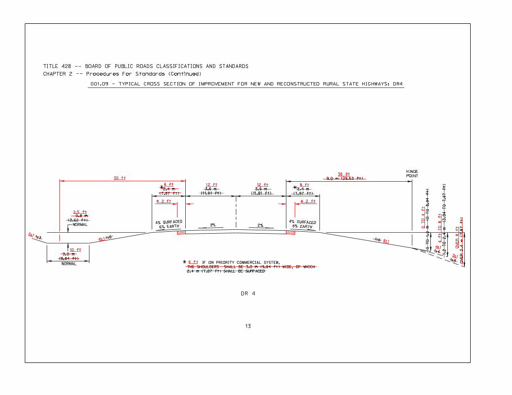
Arterial Level 3% A 110 (68.35) 500 (3.49)1700 - 2999 ADT DR4 Major Arterial Arterial Rolling 4% A 100 (62.14) 60 mph 395 1200' (4.42) 2 3.6 (11.81) 12' None 2.4 (7.87)D 8' None E 2' F 9 (29.53) 30'2,000 - 3,999 ADT Collector Level 5% A B 100 (62.14) 395 (4.42)
Collector Rolling 6.5A 6% B 90 (55.92) 305 (5.73)
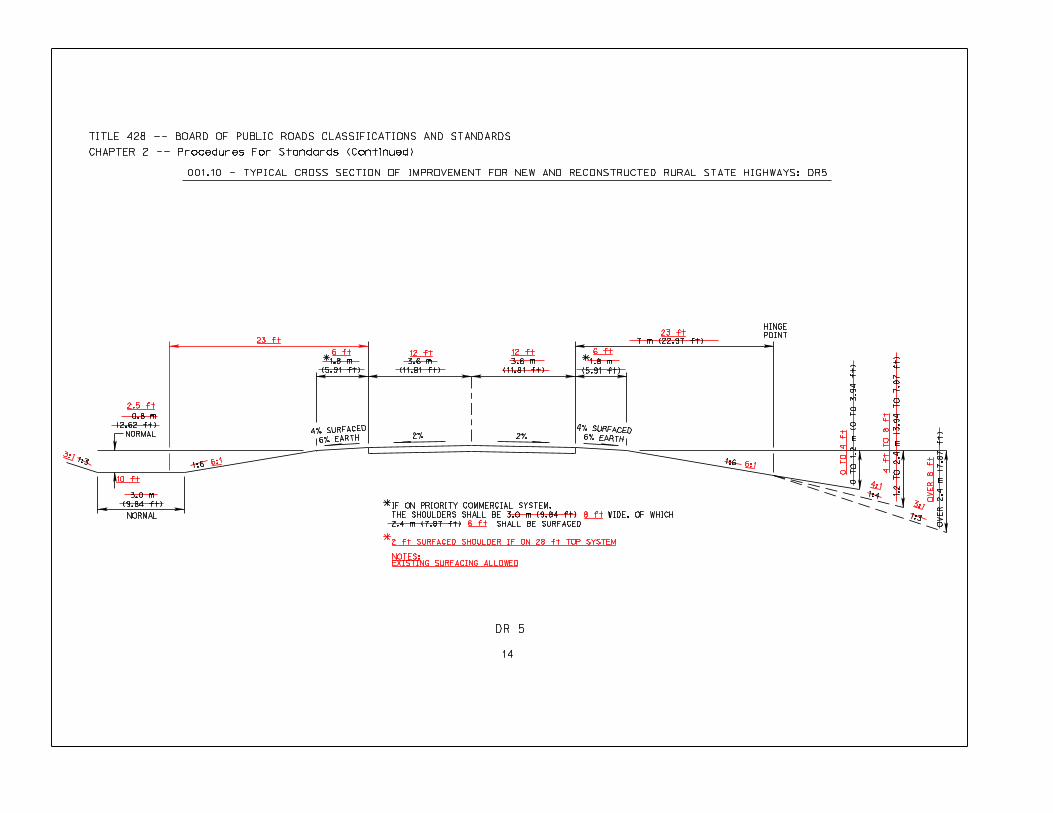
Arterial Level 3% A 110 (68.35) 500 (3.49)400 - 1699 ADT DR5 Major Arterial Arterial Rolling 4% A 100 (62.14) 60 mph 395 1200' (4.42) 2 3.6 (11.81) 12' None 1.8 (5.91)D 6' E None E F, G 7 (22.97) 23'400 - 1,999 ADT Collector Level 5% A B 100 (62.14) 395 (4.42)
Collector Rolling 6.5 A 6% B 90 (55.92) 305 (5.73)
Arterial Level 3% B 110 (68.35) 500 (3.49)
Under 400 ADT DR6 Major Arterial Arterial Rolling 4% B 100 (62.14) 60 mph 395 1200' (4.42) 2 3.6 (11.81) 12' None 1.2 (3.94)D 4' None E G 7 (22.97) 16'Collector Level 5.5 A 5% B 90 (55.92) 305 (5.73)Collector Rolling 6.5 A 6% B 90 (55.92) 305 (5.73)
Note: Projects with full federal oversight require FHWA exception for values not meeting these standards.Municipal State Highways standards 001.12 may be used in areas inside the municipal zoning boundaries, outside the corporate limits, or in rural areas that demonstrate urban traffic characteristics.
(1) “Design Year” shall be year of initial construction plus 20 years.(3) (2) Refer to NDOR “Nebraska State Highway Functional Classification Map.”(2) (3) Refer to NDOR “Nebraska National Highway Functional Classification Map.”
(4) The design speed should be equal to or greater than the anticipated posted speed limit.(5) Based on the 2004 edition of AASHTO “A Policy on Geometric Design of Highways and Streets” e max = 8%.
(5) (6) This area, measured from the edge of the through driving lane, shall have 6:1 side slopes 1:6 or flatter which may have crashworthy or break-away obstacles and shall be free of non-shielded obstacles except: (a) Traffic signals,signal poles, railroad signals, railroad tracks, bridge rails, and non-recoverable slopes behind guardrail; (b) Other obstacles including, but not limited to, ditches, recoverable slopes, driveways, intersections, bike/pedestrian paths,earth dikes, sloping curbs, raised islands, guardrails, median barriers, crash cushions, drainage inlets, drainage flumes, safety treated culverts with flared end sections, erosion control devices, roadway lighting, mailboxes, andtraffic control devices; if the NDOR, in its sole discretion, has determined that such obstacles are acceptable and are necessary for the operation and use of the highway system; (c) (b) Other obstacles if the NDOR, in its solediscretion, determines based upon an accident review and a cost benefit Roadside Safety Analysis Program (RSAP) review or a comparable AASHTO approved economic analysis, that the cost to remove or treat such obstacleexceeds the benefits from such removal or treatment – on the National Highway System (NHS). FHWA concurrence is required.
A Maximum grade may be one percent steeper for tangent lengths less than 500 ft.A B Maximum grade shown may be one two percent steeper for short tangent lengths less than 500 ft. 150 m (492.13 ft).B C 4 lanes divided allowed by special study - use DR 2 standards.C D Median widths of 16 ft are 5.4 m (17.72 ft) median width allowed at intersections and unique locations with the approval of the Director-State Engineer or his/her designee based on NDOR Traffic Division recommendation.D E 8 ft 3 m (9.84 ft) if on Priority Commercial System, refer to NDOR “Nebraska Interstate and Priority Commercial Systems Map.”E F 6 ft 2.4 m (7.87 ft) if on Priority Commercial System, refer to NDOR “Nebraska Interstate and Priority Commercial Systems Map.”F G 9 m (29.53 ft) when posted speed is 100 km/h (60 mph) or lower. 2 ft 0.6 m (1.97 ft) if on 28' Top System, refer to NDOR “28 ft Top System Map.”
Title 428 — BOARD OF PUBLIC ROADS CLASSIFICATIONS AND STANDARDS
Chapter 2 — Procedures for Standards (Continued)
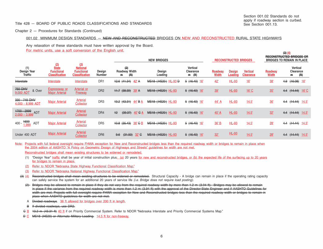
001.02 MINIMUM DESIGN STANDARDS — NEW AND RECONSTRUCTED BRIDGES ON NEW AND RECONSTRUCTED RURAL STATE HIGHWAYS
Any relaxation of these standards must have written approval by the Board.For metric units, use a soft conversion of the English unit.
(3) (4)RECONSTRUCTED BRIDGES OR
NEW BRIDGES RECONSTRUCTED BRIDGES BRIDGES TO REMAIN IN PLACE(2) (3)
(1) State National (2) Vertical VerticalDesign Year Functional Functional Design Roadway Width Design Clearance Roadway Design Vertical Roadway Clearance
Traffic Classification Classification Number m (ft) Loading m (ft) Width Loading Clearance Width m (ft)
Interstate Interstate Interstate DR1 12.6 (41.34) 42' A MS18 ( HS20 ) HL-93 D 5 (16.40) 16' 42' HL-93 16' 38' 4.9 (16.08) 16'
750 DHV & Over Expressway or Arterial or DR2 11.7 (38.39) 39' A MS18 ( HS20 ) HL-93 5 (16.40) 16' 39' HL-93 16' C 35' 4.4 (14.44) 16' C9,000 ADT Major Arterial Freeway
330 - 749 DHV Major Arterial Arterial DR3 13.2 (43.31) 44' B A MS18 ( HS20 ) HL-93 5 (16.40) 16' 44' A HL-93 14.5' 36' 4.4 (14.44) 14.5'4,000 - 8,999 ADT Collector
1700 - 2999 ADT Major Arterial Arterial DR4 12 (39.37) 40' C A MS18 ( HS20 ) HL-93 5 (16.40) 16' 40' A HL-93 14.5' 32' 4.4 (14.44) 14.5'2,000 - 3,999 Collector
400 - 1699 ADT Major Arterial Arterial DR5 10.8 (35.43) 36' C B MS18 ( HS20 ) HL-93 5 (16.40) 16' 36' B HL-93 14.5' 28' 4.4 (14.44) 14.5'1,999 Collector
Under 400 ADT Major Arterial ArterialDR6 9.6 (31.50) 32' C MS18 ( HS20 ) HL-93 5 (16.40) 16' 32' HL-93 14.5' 28' 4.4 (14.44) 14.5'Collector
Note: Projects with full federal oversight require FHWA exception for New and Reconstructed bridges less than the required roadway width or bridges to remain in place whenthe 2004 edition of AASHTO “A Policy on Geometric Design of Highways and Streets” guidelines for width are not met.
Reconstructed bridges shall mean existing structures to be widened or remodeled.
(1) “Design Year” traffic shall be year of initial construction plus: (a) 20 years for new and reconstructed bridges, or (b) the expected life of the surfacing up to 20 yearsfor bridges to remain in place.
(2) Refer to NDOR “Nebraska State Highway Functional Classification Map.”
(3) Refer to NDOR “Nebraska National Highway Functional Classification Map.”
(3) (4) Reconstructed bridges shall mean existing structures to be widened or remodeled. Structural Capacity - A bridge can remain in place if the operating rating capacitycan safely service the system for an additional 20 years of service life (i.e. Bridge does not require load posting).
(2) Bridges may be allowed to remain in place if they do not vary from the required roadway width by more than 1.2 m (3.94 ft). Bridges may be allowed to remainin place if the variance from the required roadway width is more than 1.2 m (3.94 ft) with the approval of the Director-State Engineer and if AASHTO Guidelines forwidth are met. Projects with full oversight require FHWA exception for New and Reconstructed bridges less than the required roadway width or bridges to remain inplace when AASHTO guidelines for width are not met.
A Divided roadways. 36 ft allowed for bridges over 200 ft in length.
B If divided roadways, use DR2.
C B 13.2 m (43.31 ft) 40 ft if on Priority Commercial System. Refer to NDOR “Nebraska Interstate and Priority Commercial Systems Map.”
D C MS18 (HS20) or Alternate Military Loading. 14.5 ft for non-freeway.
6
Section 001.02 Standards do notapply if roadway section is curbed.See Section 001.13.
7
Title 428 — BOARD OF PUBLIC ROADS CLASSIFICATIONS AND STANDARDS
Chapter 2 — Procedures for Standards (Continued)
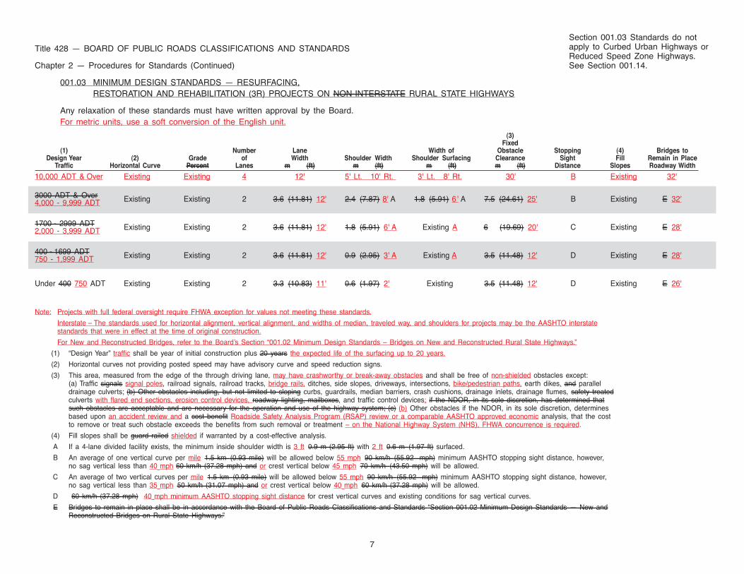
001.03 MINIMUM DESIGN STANDARDS — RESURFACING,RESTORATION AND REHABILITATION (3R) PROJECTS ON NON-INTERSTATE RURAL STATE HIGHWAYS
Any relaxation of these standards must have written approval by the Board.For metric units, use a soft conversion of the English unit.
(3)Fixed
(1) Number Lane Width of Obstacle Stopping (4) Bridges toDesign Year (2) Grade of Width Shoulder Width Shoulder Surfacing Clearance Sight Fill Remain in Place
Traffic Horizontal Curve Percent Lanes m (ft) m (ft) m (ft) m (ft) Distance Slopes Roadway Width
10,000 ADT & Over Existing Existing 4 12' 5' Lt. 10' Rt. 3' Lt. 8' Rt. 30' B Existing 32'
3000 ADT & Over Existing Existing 2 3.6 (11.81) 12' 2.4 (7.87) 8' A 1.8 (5.91) 6 ' A 7.5 (24.61) 25' B Existing E 32'4,000 - 9,999 ADT
1700 - 2999 ADT Existing Existing 2 3.6 (11.81) 12' 1.8 (5.91) 6' A Existing A 6 (19.69) 20' C Existing E 28'2,000 - 3,999 ADT
400 - 1699 ADT Existing Existing 2 3.6 (11.81) 12' 0.9 (2.95) 3' A Existing A 3.5 (11.48) 12' D Existing E 28'750 - 1,999 ADT
Under 400 750 ADT Existing Existing 2 3.3 (10.83) 11' 0.6 (1.97) 2' Existing 3.5 (11.48) 12' D Existing E 26'
Note: Projects with full federal oversight require FHWA exception for values not meeting these standards.
Interstate – The standards used for horizontal alignment, vertical alignment, and widths of median, traveled way, and shoulders for projects may be the AASHTO interstatestandards that were in effect at the time of original construction.
For New and Reconstructed Bridges, refer to the Board’s Section “001.02 Minimum Design Standards – Bridges on New and Reconstructed Rural State Highways.”
(1) “Design Year” traffic shall be year of initial construction plus 20 years the expected life of the surfacing up to 20 years.
(2) Horizontal curves not providing posted speed may have advisory curve and speed reduction signs.
(3) This area, measured from the edge of the through driving lane, may have crashworthy or break-away obstacles and shall be free of non-shielded obstacles except:(a) Traffic signals signal poles, railroad signals, railroad tracks, bridge rails, ditches, side slopes, driveways, intersections, bike/pedestrian paths, earth dikes, and paralleldrainage culverts; (b) Other obstacles including, but not limited to sloping curbs, guardrails, median barriers, crash cushions, drainage inlets, drainage flumes, safety treatedculverts with flared end sections, erosion control devices, roadway lighting, mailboxes, and traffic control devices; if the NDOR, in its sole discretion, has determined thatsuch obstacles are acceptable and are necessary for the operation and use of the highway system; (c) (b) Other obstacles if the NDOR, in its sole discretion, determinesbased upon an accident review and a cost benefit Roadside Safety Analysis Program (RSAP) review or a comparable AASHTO approved economic analysis, that the costto remove or treat such obstacle exceeds the benefits from such removal or treatment – on the National Highway System (NHS), FHWA concurrence is required.
(4) Fill slopes shall be guard railed shielded if warranted by a cost-effective analysis.
A If a 4-lane divided facility exists, the minimum inside shoulder width is 3 ft 0.9 m (2.95 ft) with 2 ft 0.6 m (1.97 ft) surfaced.
B An average of one vertical curve per mile 1.5 km (0.93 mile) will be allowed below 55 mph 90 km/h (55.92 mph) minimum AASHTO stopping sight distance, however,no sag vertical less than 40 mph 60 km/h (37.28 mph) and or crest vertical below 45 mph 70 km/h (43.50 mph) will be allowed.
C An average of two vertical curves per mile 1.5 km (0.93 mile) will be allowed below 55 mph 90 km/h (55.92 mph) minimum AASHTO stopping sight distance, however,no sag vertical less than 35 mph 50 km/h (31.07 mph) and or crest vertical below 40 mph 60 km/h (37.28 mph) will be allowed.
D 60 km/h (37.28 mph) 40 mph minimum AASHTO stopping sight distance for crest vertical curves and existing conditions for sag vertical curves.
E Bridges to remain in place shall be in accordance with the Board of Public Roads Classifications and Standards “Section 001.02 Minimum Design Standards — New andReconstructed Bridges on Rural State Highways.”
Section 001.03 Standards do notapply to Curbed Urban Highways orReduced Speed Zone Highways.See Section 001.14.
8
Title 428 — BOARD OF PUBLIC ROADS CLASSIFICATIONS AND STANDARDS
Chapter 2 — Procedures for Standards (Continued)
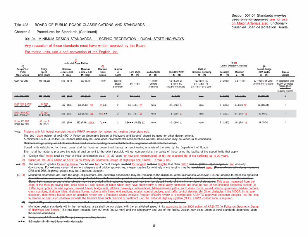
001.04 MINIMUM DESIGN STANDARDS — SCENIC RECREATION - RURAL STATE HIGHWAYS
Any relaxation of these standards must have written approval by the Board.
For metric units, use a soft conversion of the English unit.
(2)(2) (4)Horizontal Curve Radius
Lateral Obstacle Clearance(1) (3) (3)Design Year Design Desirable Minimum Maximum Number Width of Normal Design
Traffic Speed e max = 0.06 e max = 0.08 Grade of Lane Width Median Width Shoulder Width Shoulder Surfacing Desirable Minimum ROW Width AccessMajor Arterial km/h (mph) m (deg) m (deg) Percent Lanes m (ft) m (ft) m (ft) m (ft) m (ft) m (ft) m (ft) Control
Over 750 DHV 110 (68.35) 560 (3.12) 500 (3.49) 4 ★★ (Special 11 (36.09) 1.8 (5.91) Lt. 1.2. (3.94) Lt. 9 (29.53) 3.6 (11.81) 60 (196.85) (4 Lane) In accordance withlStudy) 3.6 (11.81) Ultimate 3 (9.84) Rt. 2.4 (7.87) Rt. 36 (118.11) (2 Lane) NDOR Controlled
2 Minimum if required 3 (9.84) on 2 Lane 2.4 (7.87) on 2 Lane Access Policyto the State
Highway System
400 - 750 DHV 110 (68.35) 560 (3.12) 500 (3.49) 4 ★★ 2 3.6 (11.81) None 3 (9.84) None 9 (29.53) 3.6 (11.81) 36 (118.11) "
2,000 ADT & Over 50 mph 435 (4.01) 395 (4.02) 758' 4% ★★ 2 3.6 (11.81) 12' None 2.4 (7.87) 8' None 7 (22.97) 3 (9.84) 10' 36 (118.11) "200 - 400 DHV 100 ★(62.14) c
400 - 1,999 ADT 50 mph 335 (5.21) 305 (5.73) 758' 4.5% ★★ 2 3.6 (11.81) 12' None 1.8 (5.91) 6' None 7 (22.97) 2.4 (7.87) 8' 30 (98.42) "850 - 1700 ADT 90 ★(55.92)
Under 400 ADT 40 mph A 250 (6.99) 230 (7.59) 444' A 7% ★★ 2 3.3★★★ (10.83) 11' None 1.2 (3.94) 4' None 7 (22.97) 1.8 (5.91) 6' 24 (78.74) "Under 850 ADT 80 (49.71) c
Note: Projects with full federal oversight require FHWA exception for values not meeting these standards.The 2001 2004 edition of AASHTO “A Policy on Geometric Design of Highways and Streets” should be used for other design criteria.A minimum 1.5 m (4.92 feet) flat bottom ditch may be used when environmental considerations warrant. Backslopes may be varied to fit conditions.Minimum design policy for all classifications shall include seeding or reestablishment of vegetation of all disturbed areas.Speed limits established for these routes shall be those as determined through an engineering analysis of the area by the Department of Roads.Effort shall be made to preserve the natural environment to the extent possible without compromising the safety of those using the facility, at the speed limits that apply.
(1) “Design Year” traffic shall be year of initial construction plus: (a) 20 years for new and reconstructed, or (b) the expected life of the surfacing up to 20 years.(2) Based on the 2004 edition of AASHTO “A Policy on Geometric Design of Highways and Streets” e max = 8%.
★★ (3) The maximum grades for rolling terrain may be one two percent steeper in short for tangent sections lengths less than 500 ft 150 m (492.13 ft) in length, or and one-waydowngrades. For extreme cases, at some underpass and bridge approaches, steeper grades for relatively short lengths may be considered used. (For roadways with design numbersDR5 and DR6, highway grades may be 2 percent steeper.)
(2) (4) Measured clearances are from the edge of pavement. The desirable dimensions may be reduced to the minimum lateral clearances whenever it is not feasible to meet the specifieddesirable lateral clearances. Traffic may be protected from obstacles with guardrail when desirable, but guardrail may be deleted if considered more hazardous than the obstacle.Signs, light standards and similar objects may be provided with breakaway bases and may then be placed inside of the minimum lateral clearance. This area, measured from theedge of the through driving lane, shall have 6:1 side slopes or flatter which may have crashworthy or break-away obstacles and shall be free of non-shielded obstacles except: (a)Traffic signal poles, railroad signals, railroad tracks, bridge rails, ditches, driveways, intersections, bike/pedestrian paths, earth dikes, curbs, raised islands, guardrails, median barriers,crash cushions, drainage inlets, drainage flumes, culverts with flared end sections, erosion control devices, and traffic control devices; (b) Other obstacles if the NDOR, in its solediscretion, determines based upon an accident review and a Roadside Safety Analysis Program (RSAP) review or a comparable AASHTO approved economic analysis, that the costto remove or treat such obstacle exceeds the benefits from such removal or treatment – on the National Highway System (NHS). FHWA concurrence is required.
(3) Right-of-Way width should not be less than that required for all elements of the cross section and appropriate border areas.A Minimum design standards within the recreational area shall be consistent with the established speed limits according to the 2004 edition of AASHTO “A Policy on Geometric Design
of Highways and Streets” (if it has been reduced from 90 km/h (55.92 mph) and the topography and use of the facility. Design may be to urban or rural standards depending uponthe terrain conditions.
★ Design speed 110 km/h (68.35 mph) except in rolling terrain.★★★ 3.6 meter (11.81 feet) lane width desirable.
Section 001.04 Standards may beused only for approved are for useon Major Arterials also functionallyclassified Scenic-Recreation Roads.
6:1
1:6
1:4
1:3
HINGE
POINT
1:6
9
2% TO 4%
2%4% TO 5%
0.8 m
(2.62 ft)
NORMAL
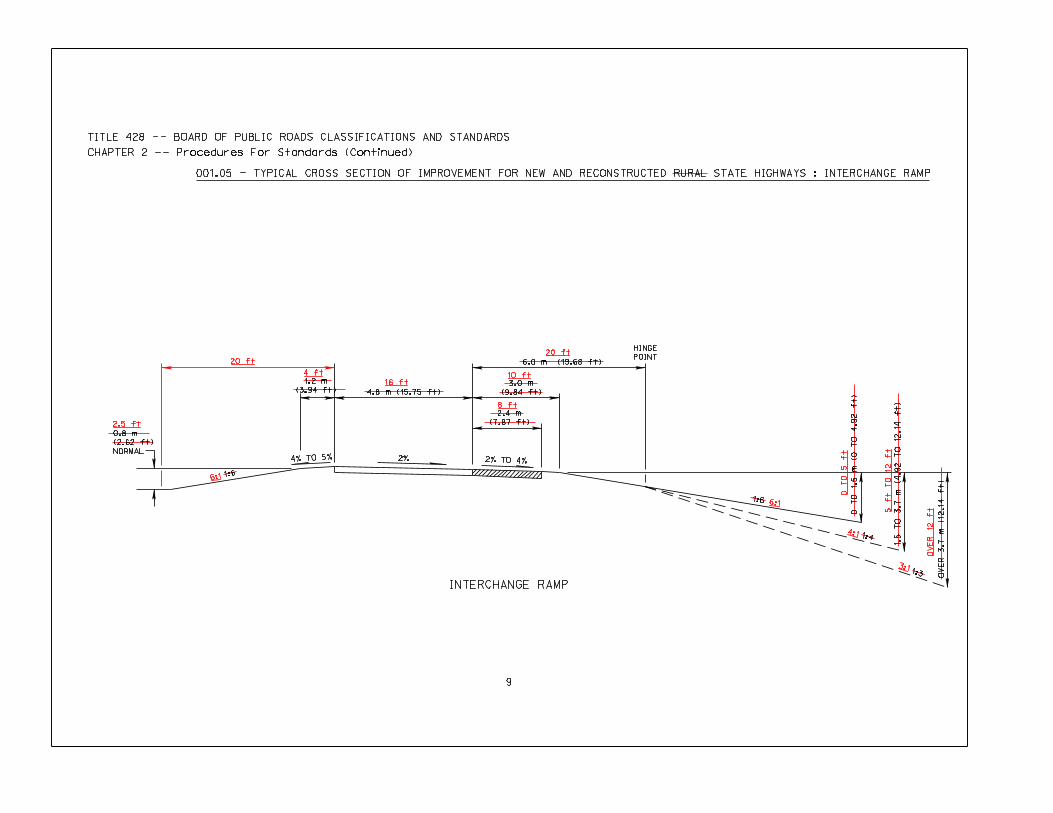
001.05 - TYPICAL CROSS SECTION OF IMPROVEMENT FOR NEW AND RECONSTRUCTED RURAL STATE HIGHWAYS : INTERCHANGE RAMP
OV
ER
3
.7
m
(1
2.1
4 ft)
1.5 T
O 3.7 m
(4.92 T
O 12.14 ft)
0 T
O 1.5 m
(0 T
O 4.92 ft)
6.0 m (19.68 ft)
3.0 m
(9.84 ft)
2.4 m
(7.87 ft)
1.2 m
(3.94 ft)
INTERCHANGE RAMP
TITLE 428 -- BOARD OF PUBLIC ROADS CLASSIFICATIONS AND STANDARDS
CHAPTER 2 -- Procedures For Standards (Continued)
20 ft
16 ft
4.8 m (15.75 ft)
2.5 ft
4 ft
20 ft
10 ft
8 ft
6:1
0 T
O 5 ft
5 ft T
O 12 ft
OV
ER
12
ft
4:1
3:1
6:1
6:1
1:61:6
1:3
1:4
LC
1:6
1:6
LC
HINGE
POINT
1:4
1:3
NORMAL
*
10
*
2% 2% 2% TO 4%
2% TO 4% 2%
2% 2% TO 4%
2% TO 4%
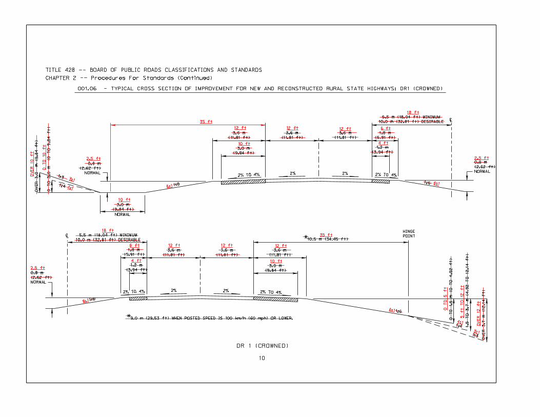
001.06 - TYPICAL CROSS SECTION OF IMPROVEMENT FOR NEW AND RECONSTRUCTED RURAL STATE HIGHWAYS: DR1 (CROWNED)
OV
ER
3.0 m
(9.84 ft)
3.0 m
(9.84 ft)
3.0 m
(9.84 ft)
0.8 m
(2.62 ft)
NORMAL
1.2 m
(3.94 ft)
1.8 m
(5.91 ft)
0.8 m
(2.62 ft)
NORMAL
1.8 m
(5.91 ft)
1.2 m
(3.94 ft)
10.5 m (34.45 ft)
3.0 m
(9.84 ft)
0 T
O 1.5 m
(0 T
O 4.92 ft)
1.5
T
O 3
.7
m
(4
.9
2 T
O 1
2.1
4 ft)
OV
ER
3
.7
m
(1
2.1
4 ft)
9.0 m (29.53 ft) WHEN POSTED SPEED IS 100 km/h (60 mph) OR LOWER.
0.8 m
(2.62 ft)
NORMAL
TITLE 428 -- BOARD OF PUBLIC ROADS CLASSIFICATIONS AND STANDARDS
CHAPTER 2 -- Procedures For Standards (Continued)
DR 1 (CROWNED)
3.6 m
(11.81 ft)
3.6 m
(11.81 ft)
3.6 m
(11.81 ft)
5.5 m (18.04 ft) MINIMUM
10.0 m (32.81 ft) DESIRABLE
5.5 m (18.04 ft) MINIMUM
10.0 m (32.81 ft) DESIRABLE
3.6 m
(11.81 ft)
3.6 m
(11.81 ft)
3.6 m
(11.81 ft)
0 T
O 3
.0
m
(0
T
O 9
.8
4 ft)
OV
ER
10 f
t
2.5 ft
3:1
4:1
0 T
O 10 ft
10 ft
35 ft
12 ft
10 ft
12 ft 12 ft
4 ft
6 ft
18 ft
2.5 ft
6:1
OV
ER
12
ft
3:1
4:1
5 ft T
O 12 ft
0 T
O 5 ft
6:1
35 ft
12 ft
10 ft
12 ft12 ft
4 ft
6 ft
18 ft
2.5 ft
6:1
6:1
1:6
1:6
1:3
1:4
LC
1:6
1:6
LC
HINGE
POINT
1:4
1:3
*
*
NORMAL
2% TO 4% 2% 2%
2%
2% 2% TO 4%
2%
2%
OR
4%
2%2%
4%
OR
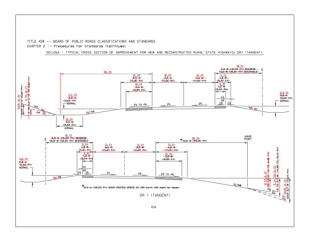
001.06A - TYPICAL CROSS SECTION OF IMPROVEMENT FOR NEW AND RECONSTRUCTED RURAL STATE HIGHWAYS: DR1 (TANGENT)
10A
0 T
O 3
.0
m
(0
T
O 9
.8
4 ft)
3.0 m
(9.84 ft)
3.0 m
(9.84 ft)
0.8 m
(2.62 ft)
NORMAL
1.8 m
(5.91 ft)
1.2 m
(3.94 ft)
0.8 m
(2.62 ft)
NORMAL
1.8 m
(5.91 ft)
1.2 m
(3.94 ft)
10.5 m (34.45 ft)
3.0 m
(9.84 ft)
OV
ER
3.7
m (
12.1
4 f
t)
9.0 m (29.53 ft) WHEN POSTED SPEED IS 100 km/h (60 mph) or lower.
0.8 m
(2.62 ft)
NORMAL
1:6
DR 1 (TANGENT)
TITLE 428 -- BOARD OF PUBLIC ROADS CLASSIFICATIONS AND STANDARDS
CHAPTER 2 -- Procedures For Standards (Continued)
OV
ER
3.0 m
(9.84 ft)
3.6 m
(11.81 ft)
3.6 m
(11.81 ft)
3.6 m
(11.81 ft)
5.5 m (18.04 ft) MINIMUM
10.0 m (32.81 ft) DESIRABLE
5.5 m (18.04 ft) MINIMUM
10.0 m (32.81 ft) DESIRABLE
3.6 m
(11.81 ft)
3.6 m
(11.81 ft)
3.6 m
(11.81 ft)
0 T
O 1.5 m
(0 T
O 4.92 ft)
1.5
T
O 3
.7
m
(4
.9
2 T
O 1
2.1
4 ft)
OV
ER
10
ft
0 T
O 10 ft
3:1
4:1
2.5 ft
35 ft
10 ft
12 ft
10 ft
12 ft 12 ft
18 ft
6 ft
4 ft
6:1
2.5 ft
2.5 ft
18 ft
6 ft
4 ft
12 ft 12 ft 12 ft
10 ft
35 ft
6:1
4:1
3:1
OV
ER
12
ft
5 ft T
O 12 ft
0 T
O 5 ft
3:1
1:61:6
3:1
4:1
LC
1:6
LC
HINGE
POINT
1:4
1:3
NORMAL
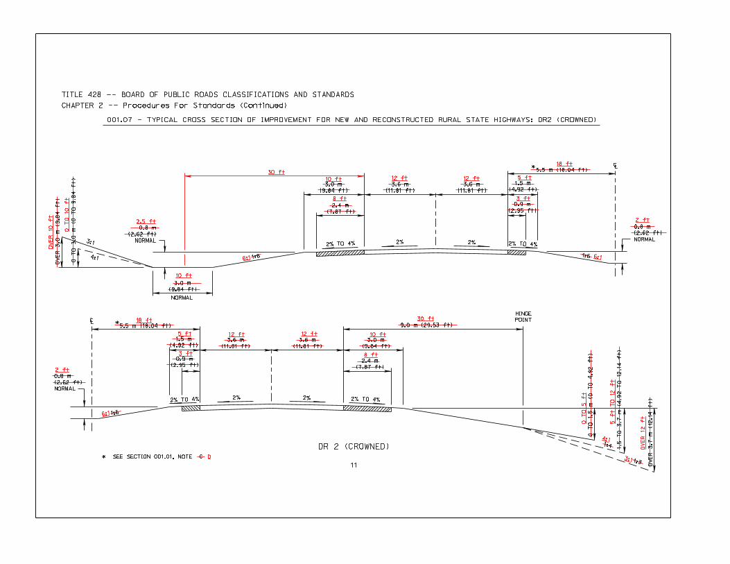
001.07 - TYPICAL CROSS SECTION OF IMPROVEMENT FOR NEW AND RECONSTRUCTED RURAL STATE HIGHWAYS: DR2 (CROWNED)
2% TO 4%
2% 2% 2% TO 4%
2% TO 4%
2%
2%2% TO 4%
*
*
0.8 m
(2.62 ft)
NORMAL
0 T
O 3
.0
m
(0
T
O 9
.8
4 ft)
3.0 m
(9.84 ft)
3.0 m
(9.84 ft)
2.4 m
(7.87 ft)
0.8 m
(2.62 ft)
NORMAL
0.9 m
(2.95 ft)
1.5 m
(4.92 ft)
OV
ER
3
.7
m
(1
2.1
4 ft)
1.5 T
O 3.7 m
(4.92 T
O 12.14 ft)
0 T
O 1
.5
m
(0
T
O 4
.9
2 ft)
3.0 m
(9.84 ft)
2.4 m
(7.87 ft)
0.8 m
(2.62 ft)
NORMAL
0.9 m
(2.95 ft)
1.5 m
(4.92 ft)
* SEE SECTION 001.01, NOTE C
11
DR 2 (CROWNED)
TITLE 428 -- BOARD OF PUBLIC ROADS CLASSIFICATIONS AND STANDARDS
CHAPTER 2 -- Procedures For Standards (Continued)
OV
ER
3.0 m
(9.84 ft)
3.6 m
(11.81 ft)
3.6 m
(11.81 ft)
9.0 m (29.53 ft)
3.6 m
(11.81 ft)
3.6 m
(11.81 ft)
5.5 m (18.04 ft)
5.5 m (18.04 ft)
OV
ER
10 f
t
0 T
O 1
0 ft
2.5 ft
10 ft
6:1
30 ft
10 ft
8 ft
12 ft 12 ft
18 ft
5 ft
3 ft
6:1
2 ft
OV
ER
12
ft
5 ft T
O 12 ft
0 T
O 5 ft
4:1
30 ft
10 ft
8 ft
12 ft12 ft5 ft
3 ft
D
18 ft
6:1
2 ft
3:1
1:6
1:6
1:3
1:4
LC
1:6
LC
1:6
HINGE
POINT
1:4
1:3
NORMAL
OR
4%
OR
4%
2% TO 4%
2%
2% 2%2%
2% TO 4%
2%
2%2%2%
11A
001.07A - TYPICAL CROSS SECTION OF IMPROVEMENT FOR NEW AND RECONSTRUCTED RURAL STATE HIGHWAYS: DR2 (TANGENT)*
*
0.8 m
(2.62 ft)
NORMAL
OV
ER
3.0 m
(9.84 ft)
3.0 m
(9.84 ft)
3.0 m
(9.84 ft)
2.4 m
(7.87 ft)
0.8 m
(2.62 ft)
NORMAL
1.5 m
(4.92 ft)
0.9 m
(2.95 ft)
0 T
O 1.5 m
(0 T
O 4.92 ft)
1.5 T
O 3.7 m
(4.92 T
O 12.14 ft)
OV
ER
3.7
m (
12
.14
ft)
3.0 m
(9.84 ft)
2.4 m
(7.87 ft)
1.5 m
(4.92 ft)
0.9 m
(2.95 ft)
0.8 m
(2.62 ft)
NORMAL
* SEE SECTION 001.01, NOTE C
DR 2 (TANGENT)
TITLE 428 -- BOARD OF PUBLIC ROADS CLASSIFICATIONS AND STANDARDS
CHAPTER 2 -- Procedures For Standards (Continued)
0 T
O 3
.0
m
(0
T
O 9
.8
4 ft) 3.6 m
(11.81 ft)
3.6 m
(11.81 ft)
9.0 m (29.53 ft)
3.6 m
(11.81 ft)
3.6 m
(11.81 ft)
5.5 m (18.04 ft)
5.5 m (18.04 ft)
OV
ER
10
ft
3:1
4:1
0 T
O 1
0 ft
2.5 ft
10 ft
6:1
30 ft
10 ft
8 ft
12 ft 12 ft 5 ft
3 ft
18 ft
6:1
2 ft
OV
ER
12
ft
5 ft T
O 12 ft
0 T
O 5 ft
4:1
6:1
30 ft
10 ft
8 ft
12 ft12 ft5 ft
3 ft
D
18 ft
6:1
2 ft
6:1 1:61:3 1:6
HINGE
POINT
1:4
1:3
NORMAL
12
2%2%
001.08 - TYPICAL CROSS SECTION OF IMPROVEMENT FOR NEW AND RECONSTRUCTED RURAL STATE HIGHWAYS: DR3
4% 4%
0.8 m
(2.62 ft)
NORMAL
0 T
O 1.2 m
(0 T
O 3.94 ft)
3.0 m
(9.84 ft)
2.4 m
(7.87 ft)
3.0 m
(9.84 ft)
2.4 m
(7.87 ft)
3.0 m
(9.84 ft)
DR 3
TITLE 428 -- BOARD OF PUBLIC ROADS CLASSIFICATIONS AND STANDARDS
CHAPTER 2 -- Procedures For Standards (Continued)
OV
ER
2
.4
m
(7
.8
7 ft)
1.2
T
O 2
.4
m
(3
.9
4 T
O 7
.8
7 ft)
9.0 m (29.53 ft)
3.6 m
(11.81 ft)
3.6 m
(11.81 ft)
3:1
2.5 ft
10 ft
30 ft
10 ft
8 ft
12 ft 12 ft
8 ft
10 ft
30 ft
6:1
0 T
O 4 ft
4:1
4 ft T
O 8 ft
OV
ER
8 f
t
3:1
6:11:61:3
1:6
HINGE
POINT
1:4
1:3
NORMAL *
* *
13
4% SURFACED6% EARTH
2%2%4% SURFACED
6% EARTH
001.09 - TYPICAL CROSS SECTION OF IMPROVEMENT FOR NEW AND RECONSTRUCTED RURAL STATE HIGHWAYS: DR4
0.8 m
(2.62 ft)
NORMAL
1.2
T
O 2
.4
m
(3
.9
4 T
O 7
.8
7 ft)
2.4 m
(7.87 ft)
2.4 m
(7.87 ft)
3.0 m
(9.84 ft)
DR 4
TITLE 428 -- BOARD OF PUBLIC ROADS CLASSIFICATIONS AND STANDARDS
CHAPTER 2 -- Procedures For Standards (Continued)
OV
ER
2
.4
m
(7
.8
7 ft)
0 T
O 1.2 m
(0 T
O 3.94 ft)
9.0 m (29.53 ft)
3.6 m
(11.81 ft)
3.6 m
(11.81 ft)
IF ON PRIORITY COMMERCIAL SYSTEM,
THE SHOULDERS SHALL BE 3.0 m (9.84 ft) WIDE, OF WHICH
2.4 m (7.87 ft) SHALL BE SURFACED
3:1
10 ft
2.5 ft
30 ft
8 ft
* 2 ft
6 ft
12 ft 12 ft 8 ft
* 2 ft
30 ft
6:1
4:1
3:1
OV
ER
8 f
t
4 ft T
O 8 ft
0 T
O 4 ft
6:11:6
1:3 1:6
HINGE
POINT
1:4
1:3
**
*
NORMAL
14
4% SURFACED
6% EARTH
2%
2%4% SURFACED
6% EARTH
001.10 - TYPICAL CROSS SECTION OF IMPROVEMENT FOR NEW AND RECONSTRUCTED RURAL STATE HIGHWAYS: DR5
0.8 m
(2.62 ft)
NORMAL
*
0 T
O 1.2 m
(0 T
O 3.94 ft)
1.8 m
(5.91 ft)
1.8 m
(5.91 ft)
3.0 m
(9.84 ft)
DR 5
TITLE 428 -- BOARD OF PUBLIC ROADS CLASSIFICATIONS AND STANDARDS
CHAPTER 2 -- Procedures For Standards (Continued)
OV
ER
2
.4
m
(7
.8
7 ft)
1.2 T
O 2.4 m
(3.94 T
O 7.87 ft)
7 m (22.97 ft)
3.6 m
(11.81 ft)
3.6 m
(11.81 ft)
IF ON PRIORITY COMMERCIAL SYSTEM,
THE SHOULDERS SHALL BE 3.0 m (9.84 ft) WIDE, OF WHICH
2.4 m (7.87 ft) SHALL BE SURFACED
3:1
10 ft
2.5 ft
23 ft
6 ft 12 ft 12 ft
8 ft
6 ft
2 ft SURFACED SHOULDER IF ON 28 ft TOP SYSTEM
6 ft
23 ft
6:1
0 T
O 4 ft
4 ft T
O 8 ft
OV
ER
8 f
t
3:1
4:1
NOTES:
EXISTING SURFACING ALLOWED
6:1
1:6
1:3
*
*
HINGE
POINT
1:6
1:4
1:3NORMAL
*
15
4% SURFACED6% EARTH2%2%
4% SURFACED
6% EARTH
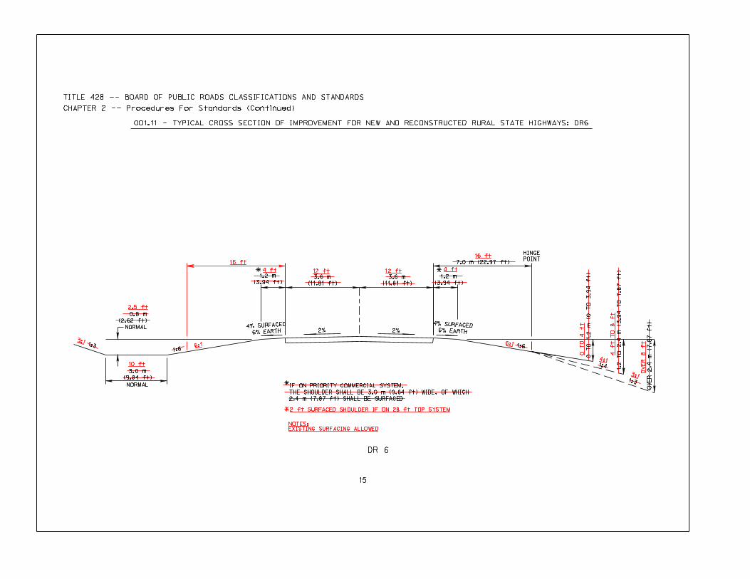
001.11 - TYPICAL CROSS SECTION OF IMPROVEMENT FOR NEW AND RECONSTRUCTED RURAL STATE HIGHWAYS: DR6
0.8 m
(2.62 ft)
NORMAL
0 T
O 1.2 m
(0 T
O 3.94 ft)
1.2 m
(3.94 ft)
1.2 m
(3.94 ft)
3.0 m
(9.84 ft)
*
DR 6
TITLE 428 -- BOARD OF PUBLIC ROADS CLASSIFICATIONS AND STANDARDS
CHAPTER 2 -- Procedures For Standards (Continued)
OV
ER
2
.4
m
(7
.8
7 ft)
1.2 T
O 2.4 m
(3.94 T
O 7.87 ft)
7.0 m (22.97 ft)
3.6 m
(11.81 ft)
3.6 m
(11.81 ft)
IF ON PRIORITY COMMERCIAL SYSTEM,
THE SHOULDER SHALL BE 3.0 m (9.84 ft) WIDE, OF WHICH
2.4 m (7.87 ft) SHALL BE SURFACED
3:1
2.5 ft
10 ft
16 ft
4 ft 12 ft 12 ft 4 ft
16 ft
2 ft SURFACED SHOULDER IF ON 28 ft TOP SYSTEM
NOTES:
EXISTING SURFACING ALLOWED
6:1
0 T
O 4 ft
4 ft T
O 8 ft
4:1
3:1
OV
ER
8 f
t
16
Title 428 — BOARD OF PUBLIC ROADS CLASSIFICATIONS AND STANDARDS
Chapter 2 — Procedures for Standards (Continued)
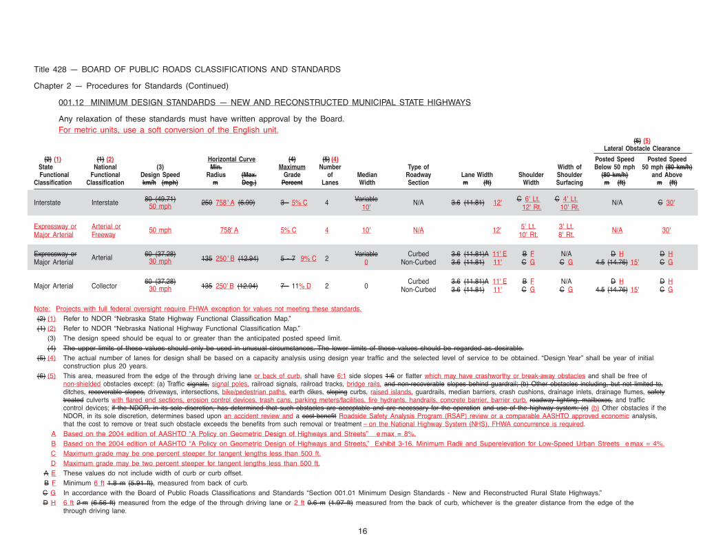
001.12 MINIMUM DESIGN STANDARDS — NEW AND RECONSTRUCTED MUNICIPAL STATE HIGHWAYS
Any relaxation of these standards must have written approval by the Board.For metric units, use a soft conversion of the English unit.
(6) (5)Lateral Obstacle Clearance
(2) (1) (1) (2) Horizontal Curve (4) (5) (4) Posted Speed Posted SpeedState National (3) Min.XXXXX Maximum Number Type of Width of Below 50 mph 50 mph (80 km/h)Functional Functional Design Speed Radius (Max. Grade of Median Roadway Lane Width Shoulder Shoulder (80 km/h) and Above
Classification Classification km/h (mph) m ft Deg.) Percent Lanes Width Section m (ft) Width Surfacing m (ft) m (ft)
Interstate Interstate 80 (49.71) 250 758' A (6.99) 3 - 5% C 4 Variable N/A 3.6 (11.81) 12' C 6' Lt. C 4' Lt. N/A C 30'50 mph 10' 12' Rt. 10' Rt.
Expressway or Arterial or 50 mph 758' A 5% C 4 10' N/A 12' 5' Lt. 3' Lt. N/A 30'Major Arterial Freeway 10' Rt. 8' Rt.
Expressway or Arterial 60 (37.28)135 250' B (12.94) 5 - 7 9% C 2
Variable Curbed 3.6 (11.81)A 11' E B F N/A D H D HMajor Arterial 30 mph 0 Non-Curbed 3.6 (11.81) 11' C G C G 4.5 (14.76) 15' C G
Major Arterial Collector60 (37.28)
135 250' B (12.94) 7 - 11% D 2 0Curbed 3.6 (11.81)A 11' E B F N/A D H D H
30 mph Non-Curbed 3.6 (11.81) 11' C G C G 4.5 (14.76) 15' C G
Note: Projects with full federal oversight require FHWA exception for values not meeting these standards.(2) (1) Refer to NDOR “Nebraska State Highway Functional Classification Map.”(1) (2) Refer to NDOR “Nebraska National Highway Functional Classification Map.”
(3) The design speed should be equal to or greater than the anticipated posted speed limit.(4) The upper limits of these values should only be used in unusual circumstances. The lower limits of these values should be regarded as desirable.
(5) (4) The actual number of lanes for design shall be based on a capacity analysis using design year traffic and the selected level of service to be obtained. “Design Year” shall be year of initialconstruction plus 20 years.
(6) (5) This area, measured from the edge of the through driving lane or back of curb, shall have 6:1 side slopes 1:6 or flatter which may have crashworthy or break-away obstacles and shall be free ofnon-shielded obstacles except: (a) Traffic signals, signal poles, railroad signals, railroad tracks, bridge rails, and non-recoverable slopes behind guardrail; (b) Other obstacles including, but not limited to,ditches, recoverable slopes, driveways, intersections, bike/pedestrian paths, earth dikes, sloping curbs, raised islands, guardrails, median barriers, crash cushions, drainage inlets, drainage flumes, safetytreated culverts with flared end sections, erosion control devices, trash cans, parking meters/facilities, fire hydrants, handrails, concrete barrier, barrier curb, roadway lighting, mailboxes, and trafficcontrol devices; if the NDOR, in its sole discretion, has determined that such obstacles are acceptable and are necessary for the operation and use of the highway system; (c) (b) Other obstacles if theNDOR, in its sole discretion, determines based upon an accident review and a cost benefit Roadside Safety Analysis Program (RSAP) review or a comparable AASHTO approved economic analysis,that the cost to remove or treat such obstacle exceeds the benefits from such removal or treatment – on the National Highway System (NHS), FHWA concurrence is required.
A Based on the 2004 edition of AASHTO “A Policy on Geometric Design of Highways and Streets” e max = 8%.B Based on the 2004 edition of AASHTO “A Policy on Geometric Design of Highways and Streets,” Exhibit 3-16. Minimum Radii and Superelevation for Low-Speed Urban Streets e max = 4%.C Maximum grade may be one percent steeper for tangent lengths less than 500 ft.D Maximum grade may be two percent steeper for tangent lengths less than 500 ft.
A E These values do not include width of curb or curb offset.B F Minimum 6 ft 1.8 m (5.91 ft), measured from back of curb.C G In accordance with the Board of Public Roads Classifications and Standards “Section 001.01 Minimum Design Standards - New and Reconstructed Rural State Highways.”D H 6 ft 2 m (6.56 ft) measured from the edge of the through driving lane or 2 ft 0.6 m (1.97 ft) measured from the back of curb, whichever is the greater distance from the edge of the
through driving lane.
17
Title 428 — BOARD OF PUBLIC ROADS CLASSIFICATIONS AND STANDARDS
Chapter 2 — Procedures for Standards (Continued)
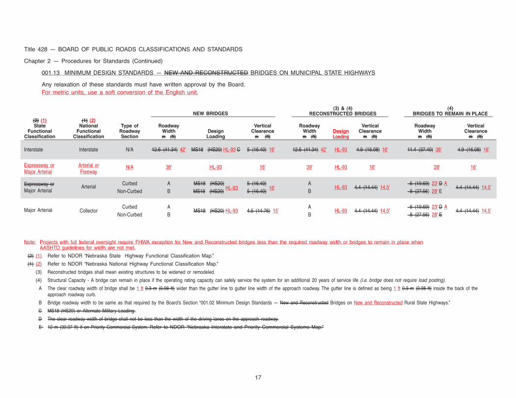
001.13 MINIMUM DESIGN STANDARDS — NEW AND RECONSTRUCTED BRIDGES ON MUNICIPAL STATE HIGHWAYS
Any relaxation of these standards must have written approval by the Board.For metric units, use a soft conversion of the English unit.
NEW BRIDGES(3) & (4) (4)
RECONSTRUCTED BRIDGES BRIDGES TO REMAIN IN PLACE(2) (1) (1) (2)State National Type of Roadway Vertical Roadway Vertical Roadway Vertical
Functional Functional Roadway Width Design Clearance Width Design Clearance Width ClearanceClassification Classification Section m (ft) Loading m (ft) m (ft) Loading m (ft) m (ft) m (ft)
Interstate Interstate N/A 12.6 (41.34) 42' MS18 (HS20) HL-93 C 5 (16.40) 16' 12.6 (41.34) 42' HL-93 4.9 (16.08) 16' 11.4 (37.40) 38' 4.9 (16.08) 16'
Expressway or Arterial or N/A 39' HL-93 16' 39' HL-93 16' 28' 16'Major Arterial Freeway
Expressway or ArterialCurbed A MS18 (HS20)
HL-935 (16.40)
16'A
HL-93 4.4 (14.44) 14.5'6 (19.69) 23' D A
4.4 (14.44) 14.5'Major Arterial Non-Curbed B MS18 (HS20)
HL-935 (16.40) B 8 (27.56) 28' E
Major Arterial CollectorCurbed A
MS18 (HS20) HL-93 4.5 (14.76) 15'A
HL-93 4.4 (14.44) 14.5'6 (19.69) 23' D A
4.4 (14.44) 14.5'Non-Curbed B B 8 (27.56) 28' E
Note: Projects with full federal oversight require FHWA exception for New and Reconstructed bridges less than the required roadway width or bridges to remain in place whenAASHTO guidelines for width are not met.
(2) (1) Refer to NDOR “Nebraska State Highway Functional Classification Map.”
(1) (2) Refer to NDOR “Nebraska National Highway Functional Classification Map.”
(3) Reconstructed bridges shall mean existing structures to be widened or remodeled.
(4) Structural Capacity - A bridge can remain in place if the operating rating capacity can safely service the system for an additional 20 years of service life (i.e. bridge does not require load posting).
A The clear roadway width of bridge shall be 1 ft 0.3 m (0.98 ft) wider than the gutter line to gutter line width of the approach roadway. The gutter line is defined as being 1 ft 0.3 m (0.98 ft) inside the back of theapproach roadway curb.
B Bridge roadway width to be same as that required by the Board’s Section “001.02 Minimum Design Standards — New and Reconstructed Bridges on New and Reconstructed Rural State Highways.”
C MS18 (HS20) or Alternate Military Loading.
D The clear roadway width of bridge shall not be less than the width of the driving lanes on the approach roadway.
E 12 m (39.37 ft) if on Priority Commercial System. Refer to NDOR “Nebraska Interstate and Priority Commercial Systems Map.”
18
Title 428 — BOARD OF PUBLIC ROADS CLASSIFICATIONS AND STANDARDS
Chapter 2 — Procedures for Standards (Continued)
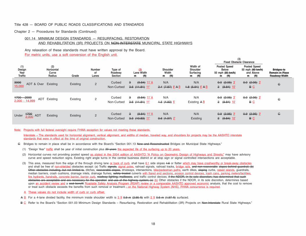
001.14 MINIMUM DESIGN STANDARDS — RESURFACING, RESTORATIONAND REHABILITATION (3R) PROJECTS ON NON-INTERSTATE MUNICIPAL STATE HIGHWAYS
Any relaxation of these standards must have written approval by the Board.For metric units, use a soft conversion of the English unit.
(3)Fixed Obstacle Clearance
(1) (2) Width of Posted Speed Posted SpeedDesign Horizontal Number Type of (3) Shoulder Shoulder Below 50 mph (80 km/h) Bridges to
Year Curve of Roadway Lane Width Width Surfacing 50 mph (80 km/h) and Above Remain in PlaceTraffic Radius Grade Lanes Section m (ft) m (ft) m (ft) m (ft) m (ft) Roadway Width
3000 ADT & Over Existing Existing 2 Curbed 3 (9.84) 11' A N/A N/A 0.9 (2.95) 3' 0.9 (2.95) 3'C15,000 Non-Curbed 3.6 (11.81) 11' 2.4 (7.87) 8' A B 1.8 (5.91) 6' A B 3 (9.84) 10' B C
1700 - 2999 ADT Existing Existing 2 Curbed 3 (9.84) 11' A N/A N/A 0.9 (2.95) 3' 0.9 (2.95) 3'C2,000 - 14,999 Non-Curbed 3.6 (11.81) 11' 1.5 (4.92) 5' Existing A B 3 (9.84) 10' B C
Under 1700 ADT Existing Existing 2 Curbed 3 (9.84) 11' A N/A N/A 0.9 (2.95) 3' 0.9 (2.95) 3' C2,000 Non-Curbed 3.3 (10.83) 11' 0.6 (1.97) 2' Existing 3 (9.84) 10' B C
Note: Projects with full federal oversight require FHWA exception for values not meeting these standards.
Interstate – The standards used for horizontal alignment, vertical alignment, and widths of median, traveled way, and shoulders for projects may be the AASHTO interstatestandards that were in effect at the time of original construction.
C Bridges to remain in place shall be in accordance with the Board’s “Section 001.13 New and Reconstructed Bridges on Municipal State Highways.”
(1) “Design Year” traffic shall be year of initial construction plus 20 years the expected life of the surfacing up to 20 years.
(2) Horizontal curves not providing posted speed as stated in the 2004 edition of AASHTO “A Policy on Geometric Design of Highways and Streets,” may have advisorycurve and speed reduction signs. Existing right angle turns in the central business district or at stop sign or signal controlled intersections are acceptable.
(3) This area, measured from the edge of the through driving lane or back of curb, shall have 6:1 side slopes 1:6 or flatter which may have crashworthy or break-away obstaclesand shall be free of non-shielded obstacles except: (a) Traffic signals, signal poles, railroad signals, railroad tracks, bridge rails, and non-recoverable slopes behind guardrail; (b)Other obstacles including, but not limited to, ditches, recoverable slopes, driveways, intersections, bike/pedestrian paths, earth dikes, sloping curbs, raised islands, guardrails,median barriers, crash cushions, drainage inlets, drainage flumes, safety treated culverts with flared end sections, erosion control devices, trash cans, parking meters/facilities,fire hydrants, handrails, concrete barrier, barrier curb, roadway lighting, mailboxes, and traffic control devices; if the NDOR, in its sole discretion, has determined that suchobstacles are acceptable and are necessary for the operation and use of the highway system; (c) (b) Other obstacles if the NDOR, in its sole discretion, determines basedupon an accident review and a cost benefit Roadside Safety Analysis Program (RSAP) review or a comparable AASHTO approved economic analysis, that the cost to removeor treat such obstacle exceeds the benefits from such removal or treatment – on the National Highway System (NHS), FHWA concurrence is required.
A These values do not include width of curb or curb offset.
A B For a 4-lane divided facility, the minimum inside shoulder width is 3 ft 0.9 m (2.95 ft) with 2 ft 0.6 m (1.97 ft) surfaced.
B C Refer to the Board’s “Section 001.03 Minimum Design Standards – Resurfacing, Restoration and Rehabilitation (3R) Projects on Non-Interstate Rural State Highways.”