Embed Size (px)
Citation preview
Regional NSW | nsw.gov.au/RegionalNSW
Neckarboo Trough Potential Strategic Release Area
Prepared by the Geological Survey of NSW
July 2020
Neckarboo Trough Potential Strategic Release Area
Regional NSW | DOC20/527326 | i
Contents Executive Summary ...................................................................................................................... 1
Introduction ................................................................................................................................... 1
Neckarboo Trough Strategic Release Area ................................................................................. 2
History of exploration ................................................................................................................... 3
Exploration data .......................................................................................................................... 3
Petroleum Assessment Analysis – Neckarboo Trough .............................................................. 8
Neckarboo Trough Potential Strategic Release Area
Regional NSW | DOC20/527326 | 1
Executive Summary In June 2016, the NSW Government introduced the NSW Strategic Release Framework for Coal
and Petroleum Exploration. The Framework implements a new process for issuing prospecting
titles and is overseen by the Advisory Body for Strategic Release. The Advisory Body will make
recommendations to the Minister about release of areas for petroleum exploration based on
consideration of geological, social, environmental, economic and operator capability factors.
The Geological Survey of NSW (GSNSW) identifies potential areas for release for petroleum
exploration, based on geological resource assessments, for consideration by the Advisory Body.
The GSNSW recommends the Neckarboo Trough for consideration by the Advisory Body under
the Strategic Release Framework. The Neckarboo Trough is a sedimentary sub-basin in the
Darling Basin in Western NSW and the assessed petroleum prospectivity, relative to other
underexplored basins and sub-basins in the State’s west, is in the highest tier. The Neckarboo
Trough is predominantly prospective for tight gas and has some potential for conventional gas.
There is no potential for coal seam gas.
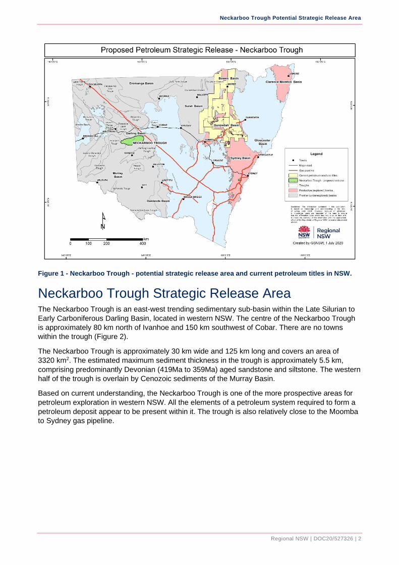
Introduction NSW contains ten main sedimentary basins that have known petroleum resources or prospectivity
potential (Figure 1). There have been oil and gas shows from previous exploration in the main
sedimentary basins and potential for discovery of conventional gas/oil, tight gas/oil, shale gas/oil
and coal seam gas.
The relatively well explored coal-bearing basins in the eastern one third of NSW have identified
coal seam gas resources. In contrast, the basins in the western two thirds of NSW are relatively
underexplored, but have potential for the discovery of petroleum resources.
The GSNSW has an ongoing program to acquire, analyse and deliver new precompetitive data to
improve understanding of the prospectivity of the underexplored basins in the western two thirds of
NSW. This program is a part of the New Frontiers Minerals and Energy Exploration Initiative and is
expected to progressively identify additional areas for consideration for strategic release.
The GSNSW has identified the Neckarboo Trough for consideration by the Advisory Body for
release as new petroleum prospecting area (Figure 1).
This area was selected based on the current understanding of the level of prospectivity and history
of petroleum exploration. The Neckarboo Trough is considered a “Frontier Basin” with respect to
petroleum exploration – it is relatively underexplored.
Neckarboo Trough Potential Strategic Release Area
Regional NSW | DOC20/527326 | 2
Figure 1 - Neckarboo Trough - potential strategic release area and current petroleum titles in NSW.
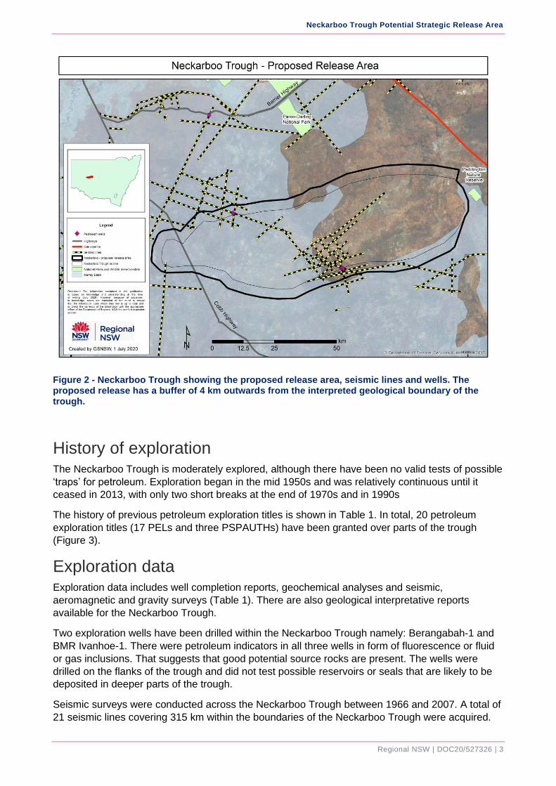
Neckarboo Trough Strategic Release Area The Neckarboo Trough is an east-west trending sedimentary sub-basin within the Late Silurian to
Early Carboniferous Darling Basin, located in western NSW. The centre of the Neckarboo Trough
is approximately 80 km north of Ivanhoe and 150 km southwest of Cobar. There are no towns
within the trough (Figure 2).
The Neckarboo Trough is approximately 30 km wide and 125 km long and covers an area of
3320 km2. The estimated maximum sediment thickness in the trough is approximately 5.5 km,
comprising predominantly Devonian (419Ma to 359Ma) aged sandstone and siltstone. The western
half of the trough is overlain by Cenozoic sediments of the Murray Basin.
Based on current understanding, the Neckarboo Trough is one of the more prospective areas for
petroleum exploration in western NSW. All the elements of a petroleum system required to form a
petroleum deposit appear to be present within it. The trough is also relatively close to the Moomba
to Sydney gas pipeline.
Neckarboo Trough Potential Strategic Release Area
Regional NSW | DOC20/527326 | 3
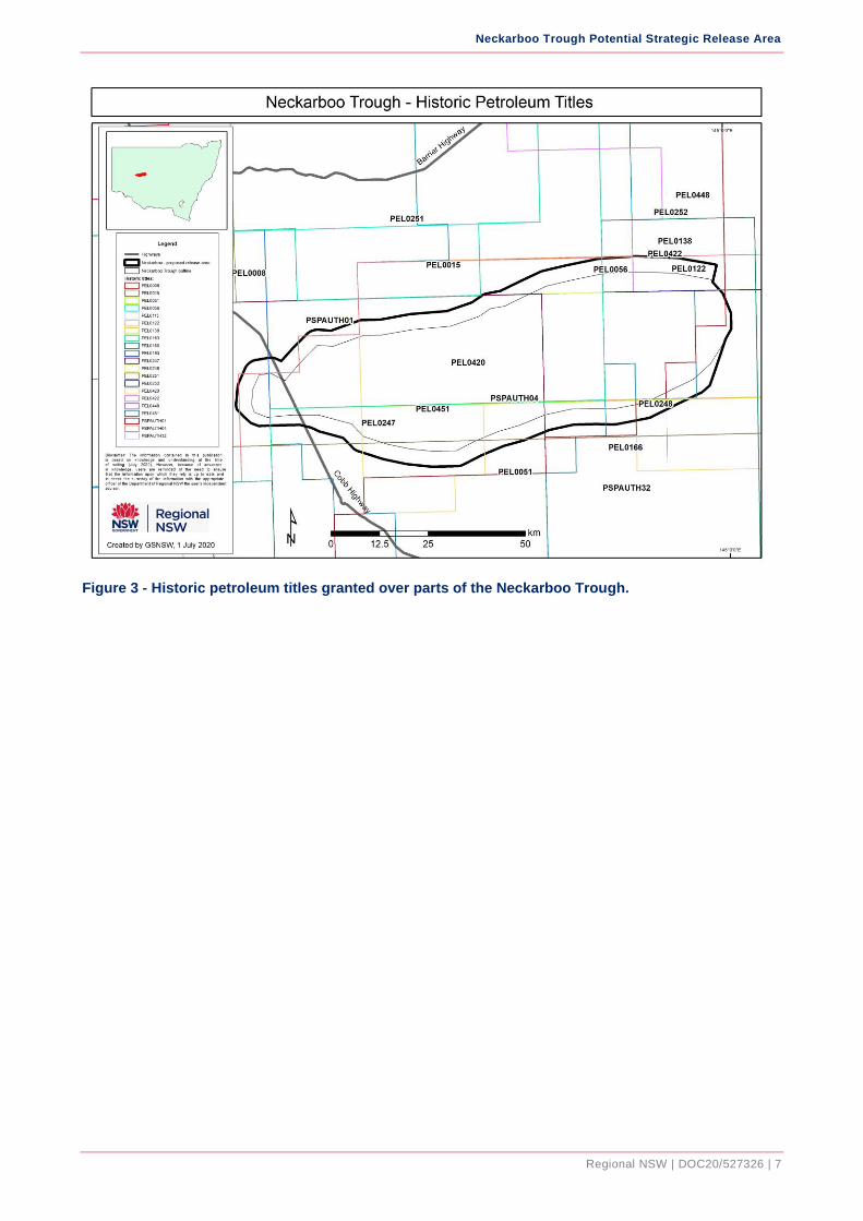
Figure 2 - Neckarboo Trough showing the proposed release area, seismic lines and wells. The proposed release has a buffer of 4 km outwards from the interpreted geological boundary of the trough.
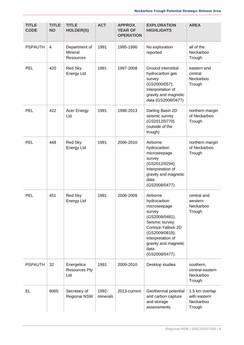
History of exploration The Neckarboo Trough is moderately explored, although there have been no valid tests of possible
‘traps’ for petroleum. Exploration began in the mid 1950s and was relatively continuous until it
ceased in 2013, with only two short breaks at the end of 1970s and in 1990s
The history of previous petroleum exploration titles is shown in Table 1. In total, 20 petroleum
exploration titles (17 PELs and three PSPAUTHs) have been granted over parts of the trough
(Figure 3).
Exploration data Exploration data includes well completion reports, geochemical analyses and seismic,
aeromagnetic and gravity surveys (Table 1). There are also geological interpretative reports
available for the Neckarboo Trough.
Two exploration wells have been drilled within the Neckarboo Trough namely: Berangabah-1 and
BMR Ivanhoe-1. There were petroleum indicators in all three wells in form of fluorescence or fluid
or gas inclusions. That suggests that good potential source rocks are present. The wells were
drilled on the flanks of the trough and did not test possible reservoirs or seals that are likely to be
deposited in deeper parts of the trough.
Seismic surveys were conducted across the Neckarboo Trough between 1966 and 2007. A total of
21 seismic lines covering 315 km within the boundaries of the Neckarboo Trough were acquired.
Neckarboo Trough Potential Strategic Release Area
Regional NSW | DOC20/527326 | 4
The quality of the seismic data varies from poor to good and original seismic field data has not
been reprocessed using modern processing software.
Table 1 - Historic petroleum exploration titles over or partially over the Neckarboo Trough.
TITLE
CODE
TITLE
NO
TITLE
HOLDER(S)
ACT APPROX.
YEAR OF
OPERATION
EXPLORATION
HIGHLIGHTS
AREA
PEL 15 Frome Broken
Hill Co. Pty Ltd
1955 1956-1958 Field mapping
(PGR1958/05)
all the
Neckarboo
Trough, except
the most
southern edge
PEL 51 Texam Oil
Corporation
1955 1960-1968 Aeromagnetic
survey: Ivanhoe
(AM009); Gravity
survey: Ivanhoe
(GR025);
Interpretation of
airborne
magnetometer
survey (AM017);
Drilling:
Berangabah-1
(WCR127)
southern
Neckarboo
Trough
PEL 56 Planet
Exploration
Company Pty
Ltd
1955 1960-1964 Interpretation of
airborne
magnetometer
survey (AM015);
Gravity survey: East
Darling (GR012);
Seismic survey:
Ivanhoe (SS057)
central and
northern
Neckarboo
Trough
PEL 115 Planet
Exploration
Company Pty
Ltd
1955 1963-1968 Drilling: Blantyre-1
(WCR110) (outside
of the trough).
central and
north-western
Neckarboo
Trough
PEL 122 Texam Oil
Corporation
1955 1965-1967 Desktop studies eastern
Neckarboo
Trough
PEL 138 Texam Oil
Corporation
1955 1967 Desktop studies eastern
Neckarboo
Trough
Neckarboo Trough Potential Strategic Release Area
Regional NSW | DOC20/527326 | 5
TITLE
CODE
TITLE
NO
TITLE
HOLDER(S)
ACT APPROX.
YEAR OF
OPERATION
EXPLORATION
HIGHLIGHTS
AREA
PEL 163 Planet
Exploration
Company Pty
Ltd
1955 1968-1971 Gravity survey:
Blantyre (GR034)
(outside of trough);
Seismic survey: Mt
Emu (SS089)
(outside of the
trough); Drilling: Mt
Emu-1 (WCR146)
(outside of the
trough).
central and
north-western
Neckarboo
Trough
PEL 166 North Star Oil
of Australia
Ltd (Energy
Resource
Corporation)
1955 1969-1973 Desktop studies eastern and
southern
Neckarboo
Trough
PEL 193 Beaver
Exploration
Australia NL
1955 1972-1977 Seismic survey:
Menindee regional
(SS105) (outside of
the trough).
western tip of
Neckarboo
Trough
PEL 247 Comserv (No.
779) Pty Ltd
1955 1980-1991 Airborne
hydrocarbon remote
sensing
(PGR1982/14);
Seismic surveys:
Darling (SS134) and
Blantyre (SS143).
central and
western
Neckarboo
Trough
PEL 248 Comserv (No.
779) Pty Ltd
1955 1980-1985 Airborne
hydrocarbon remote
sensing
(PGR1982/14)
eastern
Neckarboo
Trough
PEL 251 Comserv (No.
779) Pty Ltd
1955 1980-1991 Seismic surveys:
Darling (SS134) and
Blantyre (SS143).
northern margin
of Neckarboo
Trough
PEL 252 Comserv (No.
779) Pty Ltd
1955 1980-1985 Seismic survey:
Darling (SS134)
northern margin
of Neckarboo
Trough
PSPAUTH 1 Department of
Mineral
Resources
1991 1993-1994 No exploration
reported
all of the
Neckarboo
Trough, except
the south-
eastern edge
Neckarboo Trough Potential Strategic Release Area
Regional NSW | DOC20/527326 | 6
TITLE
CODE
TITLE
NO
TITLE
HOLDER(S)
ACT APPROX.
YEAR OF
OPERATION
EXPLORATION
HIGHLIGHTS
AREA
PSPAUTH 4 Department of
Mineral
Resources
1991 1995-1996 No exploration
reported
all of the
Neckarboo
Trough
PEL 420 Red Sky
Energy Ltd
1991 1997-2008 Ground interstitial
hydrocarbon gas
survey
(GS2000/057);
Interpretation of
gravity and magnetic
data (GS2008/0477)
eastern and
central
Neckarboo
Trough
PEL 422 Acer Energy
Ltd
1991 1998-2013 Darling Basin 2D
seismic survey
(GS2012/0770)
(outside of the
trough)
northern margin
of Neckarboo
Trough
PEL 448 Red Sky
Energy Ltd
1991 2006-2010 Airborne
hydrocarbon
microseepage
survey
(GS2012/0294);
Interpretation of
gravity and magnetic
data
(GS2008/0477).
northern margin
of Neckarboo
Trough
PEL 451 Red Sky
Energy Ltd
1991 2006-2009 Airborne
hydrocarbon
microseepage
survey
(GS2008/0481);
Seismic survey:
Corinya-Yallock 2D
(GS2009/0818);
Interpretation of
gravity and magnetic
data
(GS2008/0477).
central and
western
Neckarboo
Trough
PSPAUTH 32 Energetica
Resources Pty
Ltd
1991 2009-2010 Desktop studies southern,
central-eastern
Neckarboo
Trough
EL 8065 Secretary of
Regional NSW
1992-
minerals
2013-current Geothermal potential
and carbon capture
and storage
assessments.
1.5 km overlap
with eastern
Neckarboo
Trough
Neckarboo Trough Potential Strategic Release Area
Regional NSW | DOC20/527326 | 7
Figure 3 - Historic petroleum titles granted over parts of the Neckarboo Trough.
Neckarboo Trough Potential Strategic Release Area
Regional NSW | DOC20/527326 | 8
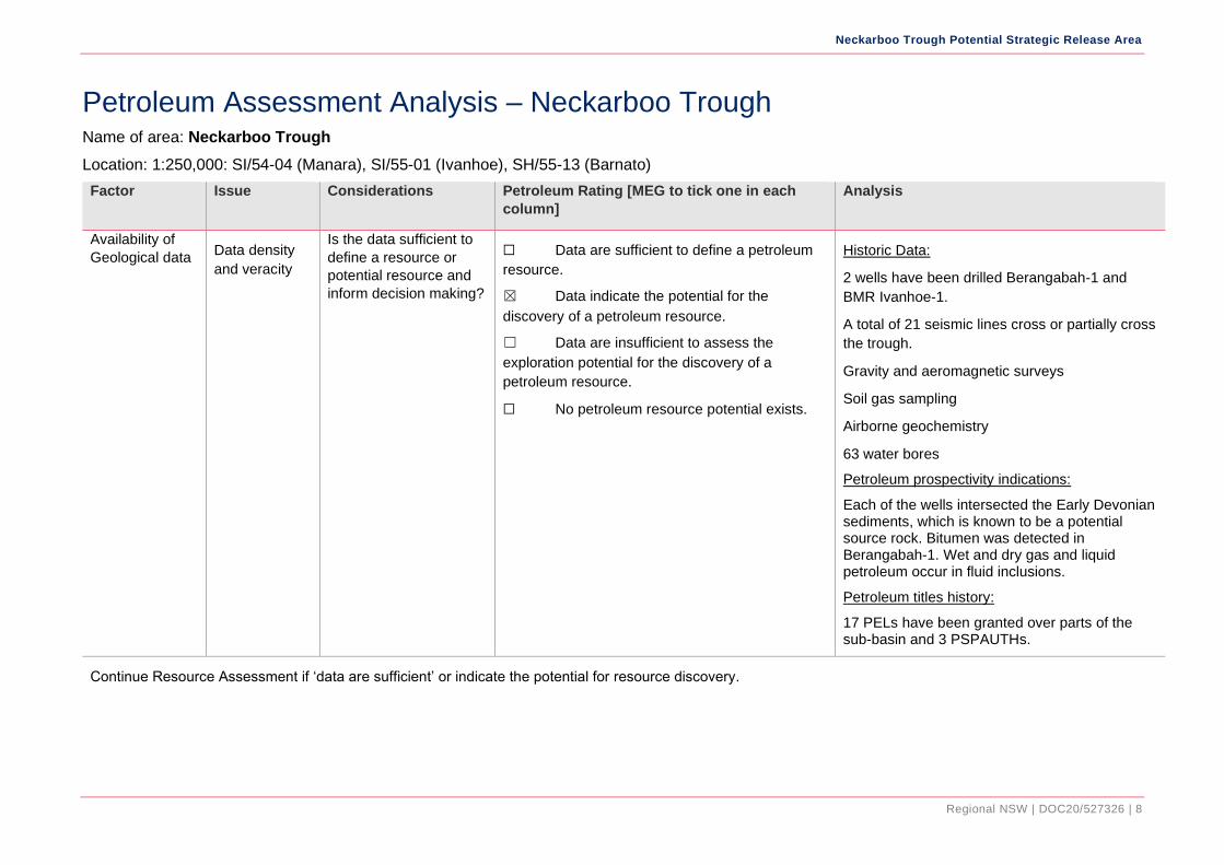
Petroleum Assessment Analysis – Neckarboo Trough Name of area: Neckarboo Trough
Location: 1:250,000: SI/54-04 (Manara), SI/55-01 (Ivanhoe), SH/55-13 (Barnato)
Factor Issue Considerations Petroleum Rating [MEG to tick one in each
column]
Analysis
Availability of
Geological data Data density
and veracity
Is the data sufficient to
define a resource or
potential resource and
inform decision making?
☐ Data are sufficient to define a petroleum
resource.
☒ Data indicate the potential for the
discovery of a petroleum resource.
☐ Data are insufficient to assess the
exploration potential for the discovery of a
petroleum resource.
☐ No petroleum resource potential exists.
Historic Data:
2 wells have been drilled Berangabah-1 and
BMR Ivanhoe-1.
A total of 21 seismic lines cross or partially cross
the trough.
Gravity and aeromagnetic surveys
Soil gas sampling
Airborne geochemistry
63 water bores
Petroleum prospectivity indications:
Each of the wells intersected the Early Devonian sediments, which is known to be a potential source rock. Bitumen was detected in Berangabah-1. Wet and dry gas and liquid petroleum occur in fluid inclusions.
Petroleum titles history:
17 PELs have been granted over parts of the sub-basin and 3 PSPAUTHs.
Continue Resource Assessment if ‘data are sufficient’ or indicate the potential for resource discovery.
Neckarboo Trough Potential Strategic Release Area
Regional NSW | DOC20/527326 | 9
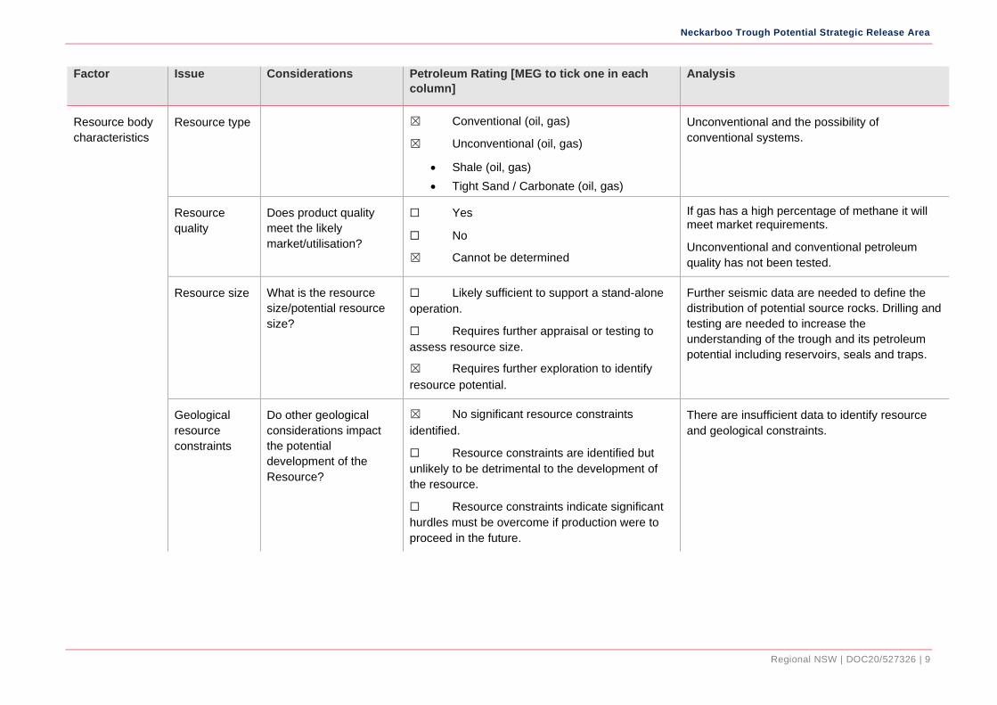
Factor Issue Considerations Petroleum Rating [MEG to tick one in each
column]
Analysis
Resource body
characteristics
Resource type ☒ Conventional (oil, gas)
☒ Unconventional (oil, gas)
• Shale (oil, gas)
• Tight Sand / Carbonate (oil, gas)
Unconventional and the possibility of
conventional systems.
Resource
quality
Does product quality
meet the likely
market/utilisation?
☐ Yes
☐ No
☒ Cannot be determined
If gas has a high percentage of methane it will meet market requirements.
Unconventional and conventional petroleum
quality has not been tested.
Resource size What is the resource
size/potential resource
size?
☐ Likely sufficient to support a stand-alone
operation.
☐ Requires further appraisal or testing to
assess resource size.
☒ Requires further exploration to identify
resource potential.
Further seismic data are needed to define the
distribution of potential source rocks. Drilling and
testing are needed to increase the
understanding of the trough and its petroleum
potential including reservoirs, seals and traps.
Geological
resource
constraints
Do other geological
considerations impact
the potential
development of the
Resource?
☒ No significant resource constraints
identified.
☐ Resource constraints are identified but
unlikely to be detrimental to the development of
the resource.
☐ Resource constraints indicate significant
hurdles must be overcome if production were to
proceed in the future.
There are insufficient data to identify resource
and geological constraints.
Neckarboo Trough Potential Strategic Release Area
Regional NSW | DOC20/527326 | 10
Factor Issue Considerations Petroleum Rating [MEG to tick one in each
column]
Analysis
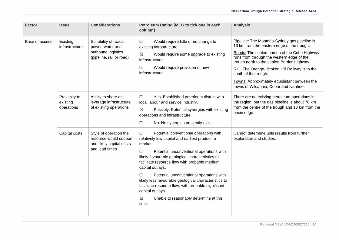
Ease of access Existing
infrastructure
Suitability of roads,
power, water and
outbound logistics
(pipeline, rail or road)
☐ Would require little or no change to
existing infrastructure.
☒ Would require some upgrade to existing
infrastructure.
☐ Would require provision of new
infrastructure.
Pipeline: The Moomba-Sydney gas pipeline is 13 km from the eastern edge of the trough.
Roads: The sealed portion of the Cobb Highway runs from through the western edge of the trough north to the sealed Barrier Highway.
Rail: The Orange- Broken Hill Railway is to the south of the trough.
Towns: Approximately equidistant between the
towns of Wilcannia, Cobar and Ivanhoe.
Proximity to
existing
operations
Ability to share or
leverage infrastructure
of existing operations
☐ Yes. Established petroleum district with
local labour and service industry.
☒ Possibly. Potential synergies with existing
operations and infrastructure.
☐ No. No synergies presently exist.
There are no existing petroleum operations in
the region, but the gas pipeline is about 70 km
from the centre of the trough and 13 km from the
basin edge.
Capital costs Style of operation the
resource would support
and likely capital costs
and lead times
☐ Potential conventional operations with
relatively low capital and earliest product to
market.
☐ Potential unconventional operations with
likely favourable geological characteristics to
facilitate resource flow with probable medium
capital outlays.
☐ Potential unconventional operations with
likely less favourable geological characteristics to
facilitate resource flow, with probable significant
capital outlays.
☒ Unable to reasonably determine at this
time.
Cannot determine until results from further
exploration and studies.
Neckarboo Trough Potential Strategic Release Area
Regional NSW | DOC20/527326 | 11
Factor Issue Considerations Petroleum Rating [MEG to tick one in each
column]
Analysis
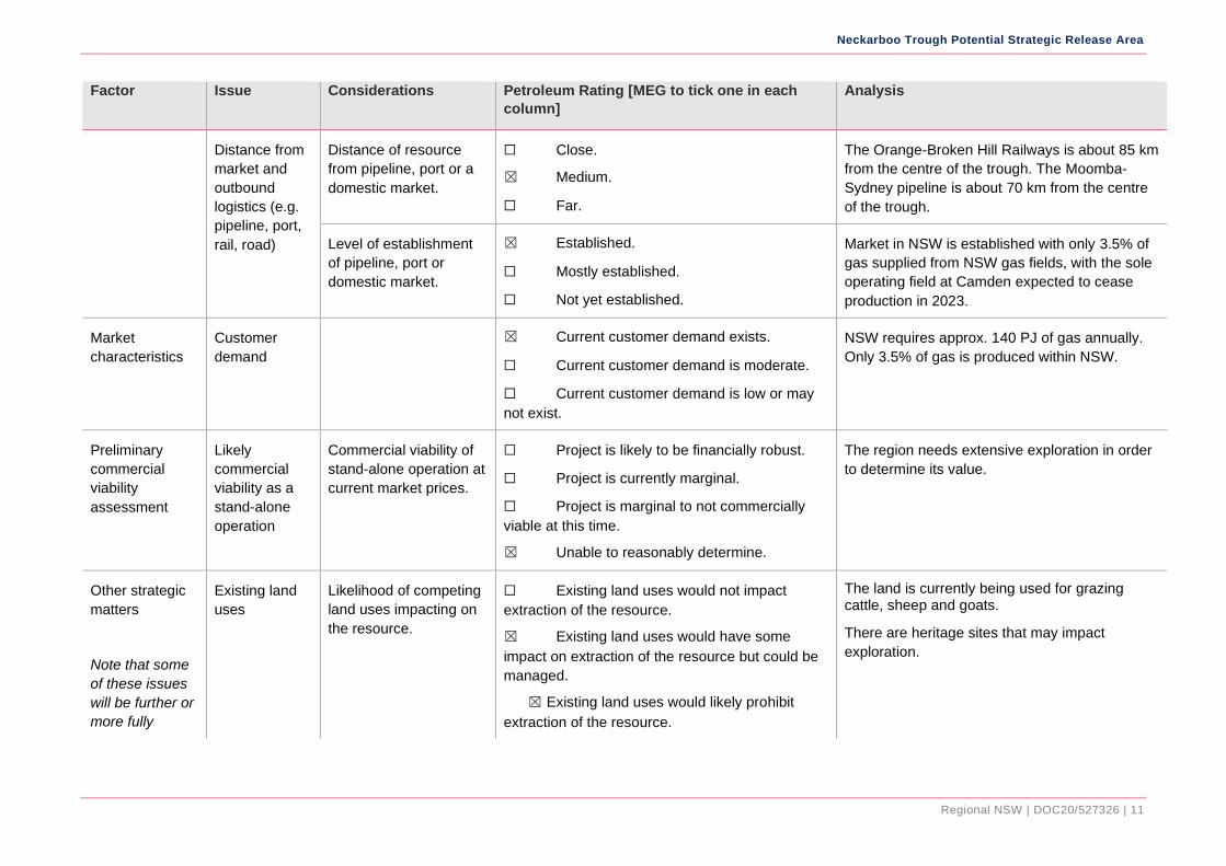
Distance from
market and
outbound
logistics (e.g.
pipeline, port,
rail, road)
Distance of resource
from pipeline, port or a
domestic market.
☐ Close.
☒ Medium.
☐ Far.
The Orange-Broken Hill Railways is about 85 km
from the centre of the trough. The Moomba-
Sydney pipeline is about 70 km from the centre
of the trough.
Level of establishment
of pipeline, port or
domestic market.
☒ Established.
☐ Mostly established.
☐ Not yet established.
Market in NSW is established with only 3.5% of
gas supplied from NSW gas fields, with the sole
operating field at Camden expected to cease
production in 2023.
Market
characteristics
Customer
demand
☒ Current customer demand exists.
☐ Current customer demand is moderate.
☐ Current customer demand is low or may
not exist.
NSW requires approx. 140 PJ of gas annually.
Only 3.5% of gas is produced within NSW.
Preliminary
commercial
viability
assessment
Likely
commercial
viability as a
stand-alone
operation
Commercial viability of
stand-alone operation at
current market prices.
☐ Project is likely to be financially robust.
☐ Project is currently marginal.
☐ Project is marginal to not commercially
viable at this time.
☒ Unable to reasonably determine.
The region needs extensive exploration in order
to determine its value.
Other strategic
matters
Note that some
of these issues
will be further or
more fully
Existing land
uses
Likelihood of competing
land uses impacting on
the resource.
☐ Existing land uses would not impact
extraction of the resource.
☒ Existing land uses would have some
impact on extraction of the resource but could be
managed.
☒ Existing land uses would likely prohibit
extraction of the resource.
The land is currently being used for grazing cattle, sheep and goats.
There are heritage sites that may impact
exploration.
Neckarboo Trough Potential Strategic Release Area
Regional NSW | DOC20/527326 | 12
Factor Issue Considerations Petroleum Rating [MEG to tick one in each
column]
Analysis
considered in
DRNSW’s
strategic issues
assessment
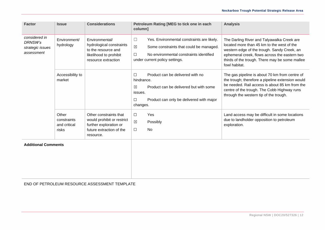
Environment/
hydrology
Environmental/
hydrological constraints
to the resource and
likelihood to prohibit
resource extraction
☐ Yes. Environmental constraints are likely.
☒ Some constraints that could be managed.
☐ No environmental constraints identified
under current policy settings.
The Darling River and Talyawalka Creek are
located more than 45 km to the west of the
western edge of the trough. Sandy Creek, an
ephemeral creek, flows across the eastern two
thirds of the trough. There may be some mallee
fowl habitat.
Accessibility to
market
☐ Product can be delivered with no
hindrance.
☒ Product can be delivered but with some
issues.
☐ Product can only be delivered with major
changes.
The gas pipeline is about 70 km from centre of
the trough; therefore a pipeline extension would
be needed. Rail access is about 85 km from the
centre of the trough. The Cobb Highway runs
through the western tip of the trough.
Other
constraints
and critical
risks
Other constraints that
would prohibit or restrict
further exploration or
future extraction of the
resource.
☐ Yes
☒ Possibly
☐ No
Land access may be difficult in some locations
due to landholder opposition to petroleum
exploration.
Additional Comments
END OF PETROLEUM RESOURCE ASSESSMENT TEMPLATE