Embed Size (px)
Citation preview

Regional NSW | nsw.gov.au/RegionalNSW
Pondie Range Trough Potential Strategic Release Area
Prepared by the Geological Survey of NSW
July 2020

Pondie Range Trough Potential Strategic Release Area
Regional NSW | DOC20/527332 | i
Contents Executive Summary ...................................................................................................................... 1
Introduction ................................................................................................................................... 1
Pondie Range Strategic Release Area ......................................................................................... 2
History of exploration ................................................................................................................... 4
Exploration data .......................................................................................................................... 4
Petroleum Assessment Analysis – Pondie Range Trough ........................................................ 8

Pondie Range Trough Potential Strategic Release Area
Regional NSW | DOC20/527332 | 1
Executive Summary In June 2016, the NSW Government introduced the NSW Strategic Release Framework for Coal
and Petroleum Exploration. The Framework implements a new process for issuing prospecting
titles and is overseen by the Advisory Body for Strategic Release. The Advisory Body will make
recommendations to the Minister about release of areas for petroleum exploration based on
consideration of geological, social, environmental, economic and operator capability factors.
The Geological Survey of NSW (GSNSW) identifies potential areas for release for petroleum
exploration, based on geological resource assessments, for consideration by the Advisory Body.
The GSNSW recommended the Pondie Range Trough for consideration by the Advisory Body
under the Strategic Release Framework in 2017. The Pondie Range Trough is a sedimentary sub-
basin in the Darling Basin in Western NSW and the assessed petroleum prospectivity, relative to
other underexplored basins and sub-basins in the State’s west, is in the highest tier. The Pondie
Range Trough is predominantly prospective for tight gas and has some potential for conventional
gas. There is no potential for coal seam gas.
Introduction NSW contains ten main sedimentary basins that have known petroleum resources or prospectivity
potential (Figure 1). There have been oil and gas shows from previous exploration in the main
sedimentary basins and potential for discovery of conventional gas/oil, tight gas/oil, shale gas/oil
and coal seam gas.
The relatively well explored coal-bearing basins in the eastern one third of NSW have identified
coal seam gas resources. In contrast, the basins in the western two thirds of NSW are relatively
underexplored, but have potential for the discovery of petroleum resources.
The GSNSW has an ongoing program to acquire, analyse and deliver new precompetitive data to
improve understanding of the prospectivity of the underexplored basins in the western two thirds of
NSW. This program is a part of the New Frontiers Minerals and Energy Exploration Initiative and is
expected to progressively identify additional areas for consideration for strategic release.
The GSNSW has identified the Pondie Range Trough for consideration by the Advisory Body for
release as a new petroleum prospecting area (Figure 1).
This area was selected based on the current understanding of the level of prospectivity and history
of petroleum exploration. The Pondie Range Trough is considered a “Frontier Basin” with respect
to petroleum exploration – it is relatively underexplored.

Pondie Range Trough Potential Strategic Release Area
Regional NSW | DOC20/527332 | 2
Figure 1 – Pondie Range Trough - potential strategic release area and current petroleum titles in NSW.
Pondie Range Strategic Release Area The Pondie Range Trough is a sub-basin of the Late Silurian to Early Carboniferous Darling Basin,
located in western New South Wales. It is approximately 5 km northwest of Wilcannia and extends
west. There are no towns or villages within the trough (Figure 2). The Pondie Range Trough is
partially overlain by the Eromanga Basin (part of the Great Australian Basin).
The Pondie Range Trough is a roughly triangular shaped trough approximately 80 by 40 km across
(3 200 km2). Based on the seismic data interpretation as well as gravimetric depth-to-basement
estimates, maximum sediment thicknesses of 8-12 km are attained within the Pondie Range
Trough (Pearson, 2003).
There are untested petroleum plays present in the Pondie Range Trough. The elements required
to form a petroleum deposit are potentially within the trough, but more exploration is needed to
confirm this. The trough is relatively close to the Moomba-Sydney gas pipeline and the Barrier
Highway intersects the southern part of the trough.
Pondie Range Trough Potential Strategic Release Area
Regional NSW | DOC20/527332 | 3
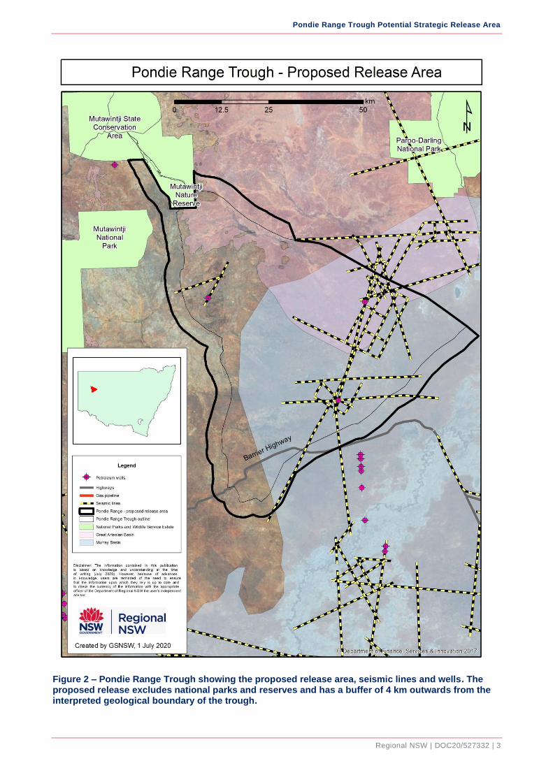
Figure 2 – Pondie Range Trough showing the proposed release area, seismic lines and wells. The proposed release excludes national parks and reserves and has a buffer of 4 km outwards from the interpreted geological boundary of the trough.

Pondie Range Trough Potential Strategic Release Area
Regional NSW | DOC20/527332 | 4
History of exploration The Pondie Range Trough is underexplored for petroleum. Seismic surveys were acquired mostly
over the eastern half of the trough and only two exploration wells have been drilled.
The history of petroleum exploration titles is shown in Table 1. Eight PELs and two PSPAUTHs
have been held over various parts of the trough from 1958 to 2013 (Figure 3). In 2013 the NSW
Government was granted an exploration licence for Group 8 minerals to assess the geothermal
energy and CO2 storage potential, as part of the CO2 Storage Assessment Program undertaken by
Coal Innovation NSW. In 2014 the exploration well Mena Murtee-1 was drilled identifying the
presence of potential reservoirs.
Exploration data The exploration data includes well completion reports, geochemical analyses, seismic surveys,
gravity and magnetics surveys, and soil gas surveys. There are also interpretative geological
reports available for the trough (Table 1).
Pondie Range-1 commenced drilling in 1966 and was completed in 1967 by Mid-Eastern Oil NL.
There are also seven stratigraphic wells in the Pondie Range Trough. Six of them, Pondie Range
DDH1 to DDH6, drilled by Planet Exploration Company Pty Ltd in 1968-1969, are less than150 m
deep, but limited data are preserved on these wells. The seventh well Mena Murtee-1 is a deep
stratigraphic test well drilled by Coal Innovation NSW. There were no hydrocarbon shows during
drilling, but the soil gas survey showed elevated background methane, ethane and propane values
over the Pondie Range anticline. There is reasonable porosity and permeability within the Middle to
Upper Devonian formations, but neither Pondie Range-1 nor Mena Murtee-1 drilled through any
potential ‘traps’.
Thirty seismic lines, totalling about 375 km, were completed from 1965 to 2004. The quality of
seismic data is variable and can be divided into two groups.
The first group is the data acquired prior to 1983 and is generally of poor to moderate quality. Not
all of this data is digital, as some old paper records have not been converted. The second group
encompasses the seismic data acquired by BHP Petroleum in 1983, GSNSW and Eastern Star
Gas in 2004. The second group of data is vastly superior to that of the first group and is all digital.
These data were reprocessed in 2004, taking advantage of improved processing algorithms and
more powerful computers leading to improved and less noisy data.
Table 1 - Historic petroleum exploration titles over or partially over the Pondie Range Trough.
TITLE
CODE
TITLE
NO
TITLE HOLDER ACT APPROX.
YEAR OF
OPERATION
EXPLORATION
HIGHLIGHTS
AREA
PEL 15 Frome Broken Hill Co Pty Ltd
1955 1958 Desktop studies eastern
Pondie
Range
Trough

Pondie Range Trough Potential Strategic Release Area
Regional NSW | DOC20/527332 | 5
TITLE
CODE
TITLE
NO
TITLE HOLDER ACT APPROX.
YEAR OF
OPERATION
EXPLORATION
HIGHLIGHTS
AREA
PEL 35 Planet Exploration Company Pty Ltd
Oil Development NL
1955 1959-1963 Airborne
magnetometer survey,
Darling area, joint
venture (AM015);
Seismic survey –
Tibooburra refraction -
reflection survey
(SS028) (outside of
trough); Desktop
studies.
north-
western
tip of
Pondie
Range
Trough
PEL 38 Woodside Darling
River Oil Co NL
(title holder) & Mid-
Eastern Oil NL
(operator)
1955 1960-1967 Drilling: Pondie
Range-1 (WCR123);
Mt Jack-1 (WCR069)
(outside of the trough).
Seismic surveys:
White Cliffs (SS047
and SS051); Mt Jack
(SS016); Core
sampling: Pondie
Range-1(L0000151);
Mt Jack -1
(L0000150); Gravity
survey: White Cliffs
(GR016). Airborne
magnetometer survey
– Darling area
(AM015).
eastern
Pondie
Range
Trough
PEL 78 Planet Exploration Company Pty Ltd
1955 1962-1968 Seismic survey:
Mootwingee (SS042);
Gravity surveys:
Mootwingee (GR020
and GR014); Stephens
Creek (GR011);
Aeromagnetic survey:
Mootwingee (AM020);
Desktop studies.
western
Pondie
Range
Trough
PEL 142 Planet Exploration Company Pty Ltd
1955 1968-1969 Drilling: Pondie Range
DDH1-6 (WCR 167);
Gravity surveys:
Pondie Range
(GR039) and Peri
Lake (GR030).
eastern
Pondie
Range
Trough
(same as
PEL 38)
PEL 155 Planet Exploration
Company Pty Ltd
1955 1969-1970 Seismic survey:
Mootwingee –
refraction; Drilling:
Gnalta-1 (WCR144)
(outside the trough).
western
Pondie
Range
Trough

Pondie Range Trough Potential Strategic Release Area
Regional NSW | DOC20/527332 | 6
TITLE
CODE
TITLE
NO
TITLE HOLDER ACT APPROX.
YEAR OF
OPERATION
EXPLORATION
HIGHLIGHTS
AREA
PEL 250 Comserv (No. 779)
Pty Ltd
1955 1980-1991 Seismic surveys:
Darling (SS134) and
Blantyre (SS143);
Gravity survey: Pondie
Range Trough -
regional
(PGR1981/06)
Pondie
Range
Trough
PSPAUTH 1 Department of Mineral Resources
1991 1993-1994 Desktop studies Pondie
Range
Trough
PEL 424 Acer Energy Ltd 1991 1998-2013 Seismic survey:
Pondie Range -
regional
(GS2012/0770); Soil
gas sampling
(GS2004/216);
Desktop studies.
Pondie
Range
Trough
PSPAUTH 12 Hardie Infrastructure Pty Ltd
1991 2006-2008 Desktop studies Pondie Range Trough
EL 9066 Secretary of Regional NSW
1992-
minerals
2013-current Drilling: Mena Murtee-
1 (GS2015/0405);
Geothermal potential
and carbon capture
and storage
assessments.
Pondie Range Trough

Pondie Range Trough Potential Strategic Release Area
Regional NSW | DOC20/527332 | 7
Figure 3 - Historic petroleum titles granted over parts of the Pondie Range Trough.

Pondie Range Trough Potential Strategic Release Area
Regional NSW | CM ref. if applicable | 8
Petroleum Assessment Analysis – Pondie Range Trough Name of area: Pondie Range Trough
Location: 1:250,000: SH/54-16 (Wilcannia)
Factor Issue Considerations Petroleum Rating [MEG to tick one in each
column]
Analysis
Availability of
Geological data Data density and veracity
Is the data sufficient to define a resource or potential resource and inform decision making?
☐ Data are sufficient to define a petroleum
resource.
☒ Data indicate the potential for the
discovery of a petroleum resource.
☐ Data are insufficient to assess the
exploration potential for the discovery of a petroleum resource.
☐ No petroleum resource potential exists.
Historic Data:
2 deep wells have been drilled. Pondie Range-1 was drilled from 1966-1967 and Mena Murtee-1 was drilled in 2014.
6 shallow (<150 m deep) stratigraphic holes were drilled in 1968-69.
From 1965 to 2004, 30 seismic lines covering 375 km.
61 water bores
Gravity and aeromagnetic surveys
Soil gas sampling
Petroleum prospectivity indications:
Elevated background methane, ethane and propane values from the soil gas survey. A thick Devonian sequence is present including the Early Devonian, which is known to be a potential source rock. The above Middle-Upper Devonian has good porosity and permeability and could be potential reservoirs. Seals are intraformational or overlying the Late Devonian.
Petroleum title history:
8 PELs and 2 PSPAUTHs have been granted over parts of the trough.

Pondie Range Trough Potential Strategic Release Area
Regional NSW | CM ref. if applicable | 9
Factor Issue Considerations Petroleum Rating [MEG to tick one in each
column]
Analysis
☒ Continue Resource Assessment if ‘data are sufficient’ or indicate the potential for resource discovery.
Resource body
characteristics Resource type ☒ Conventional (oil, gas)
☒ Unconventional (oil, gas)
• Tight Sand / Carbonate (oil, gas)
Unconventional and the possibility of
conventional systems.
Resource
quality
Does product quality
meet the likely
market/utilisation?
☐ Yes
☐ No
☒ Cannot be determined
If gas has a high percentage of methane it will meet market requirements.
Unconventional and conventional petroleum
quality has not been tested.
Resource size What is the resource
size/potential resource
size?
☐ Likely sufficient to support a stand-alone
operation.
☐ Requires further appraisal or testing to
assess resource size.
☒ Requires further exploration to identify
resource potential.
Further seismic data are needed to define the
distribution of potential source rocks. Drilling and
testing are needed to better understand the
trough and its petroleum potential.
Geological
resource
constraints
Do other geological
considerations impact
the potential
development of the
resource?
☒ No significant resource constraints
identified.
☐ Resource constraints are identified but
unlikely to be detrimental to the development of the resource.
☐ Resource constraints indicate significant
hurdles must be overcome if production were
to proceed in the future.
There are insufficient data to identify resource
and geological constraints.

Pondie Range Trough Potential Strategic Release Area
Regional NSW | CM ref. if applicable | 10
Factor Issue Considerations Petroleum Rating [MEG to tick one in each
column]
Analysis
Ease of access Existing
infrastructure
Suitability of roads,
power, water and
outbound logistics
(pipeline, rail or road)
☐ Would require little or no change to
existing infrastructure.
☒ Would require some upgrade to existing
infrastructure.
☐ Would require provision of new
infrastructure.
Pipeline: The Moomba-Sydney gas pipeline is 56 km from the northeastern edge of the trough.
Roads: The sealed Barrier Highway goes through the southern part of the trough and the sealed Opal Miners Way goes through the middle of the trough.
Rail: The Orange- Broken Hill Railway is to the south of the trough.
Towns: Wilcannia is to the south of the trough
with a population of approximately 600 people.
Proximity to
existing
operations
Ability to share or
leverage infrastructure
of existing operations
☐ Yes. Established petroleum district with
local labour and service industry.
☒ Possibly. Potential synergies with existing
operations and infrastructure.
☐ No. No synergies presently exist.
There are no existing petroleum operations in
the region, but the gas pipeline is about 90 km
from the centre of the trough and 56 km from the
edge of the trough.
Capital costs Style of operation the
resource would support
and likely capital costs
and lead times
☐ Potential conventional operations with
relatively low capital and earliest product to market.
☐ Potential unconventional operations with
likely favourable geological characteristics to facilitate resource flow with probable medium capital outlays.
☐ Potential unconventional operations with
likely less favourable geological characteristics to facilitate resource flow, with probable significant capital outlays.
☒ Unable to reasonably determine at this
time.
Cannot determine until further exploration and
studies are completed.

Pondie Range Trough Potential Strategic Release Area
Regional NSW | CM ref. if applicable | 11
Factor Issue Considerations Petroleum Rating [MEG to tick one in each
column]
Analysis
Distance from
market and
outbound
logistics (e.g.
pipeline, port,
rail, road)
Distance of resource
from pipeline, port or a
domestic market.
☐ Close.
☒ Medium.
☐ Far.
The Orange-Broken Hill Railways is about
120 km from the centre of the trough. The
Moomba-Sydney pipeline is about 90 km from
the centre of the trough.
Level of establishment
of pipeline, port or
domestic market.
☒ Established.
☐ Mostly established.
☐ Not yet established.
Market in NSW is established with only 3.5% of
gas supplied from NSW gas fields, with sole
operating field at Camden expected to cease
production in 2023.
Market
characteristics Customer
demand
☒ Current customer demand exists.
☐ Current customer demand is moderate.
☐ Current customer demand is low or may
not exist.
NSW requires approx. 140 PJ of gas annually.
Only 3.5% of gas is produced within NSW.
Preliminary
commercial
viability
assessment
Likely
commercial
viability as a
stand-alone
operation
Commercial viability of
stand-alone operation at
current market prices.
☐ Project is likely to be financially robust.
☐ Project is currently marginal.
☐ Project is marginal to not commercially
viable at this time.
☒ Unable to reasonably determine.
The region needs extensive exploration in order
to determine its value.
Other strategic matters
Note that some
of these issues
will be further or
more fully
Existing land
uses
Likelihood of competing
land uses impacting on
the resource.
☐ Existing land uses would not impact
extraction of the resource.
☒ Existing land uses would have some
impact on extraction of the resource but could be managed.
☐ Existing land uses would likely prohibit
extraction of the resource.
The land is currently being used for grazing cattle, sheep and goats.
There are heritage sites that may impact
exploration.

Pondie Range Trough Potential Strategic Release Area
Regional NSW | CM ref. if applicable | 12
Factor Issue Considerations Petroleum Rating [MEG to tick one in each
column]
Analysis
considered in
DRNSW’s
strategic issues
assessment
Environment/
hydrology
Environmental/
hydrological constraints
to the resource and
likelihood to prohibit
resource extraction
☐ Yes. Environmental constraints are likely.
☒ Some constraints that could be managed.
☐ No environmental constraints identified
under current policy settings.
The Pondie Range Trough is partially overlain
by the southern margin of the Great Australian
Basin (Eromanga Basin). The Darling River is to
the southeast of the trough, and there are
several minor creeks that flow across the trough.
Accessibility to
market
☐ Product can be delivered with no
hindrance.
☒ Product can be delivered but with some
issues.
☐ Product can only be delivered with major
changes.
The Moomba Sydney gas pipeline is about 90
km from centre of the trough; therefore a
pipeline extension would be needed. Existing rail
access is about 120 km from the centre of the
trough. Highways and major roads run through
the trough.
Other
constraints
and critical
risks
Other constraints that
would prohibit or restrict
further exploration or
future extraction of the
resource.
☐ Yes
☒ Possibly
☐ No
Land access may be difficult in some locations
due to landholder opposition to petroleum
exploration.
Additional Comments
END OF PETROLEUM RESOURCE ASSESSMENT TEMPLATE