Embed Size (px)
Citation preview
COUNTRY REPORT
ON
GEOSPATIAL INFORMATION MANAGEMENT
IN NEPAL
Government of Nepal
Ministry of Land Reform and Management
SURVEY DEPARTMENT
PO Box 9435
Min Bhavan, Kathmandu
Nepal
Tel : + 977 1 4622713
+ 977 1 4622736
Fax : + 977 1 4622957
Country Report on Geospatial Information Management in Nepal
Country Report Nepal Page 1
1. THE COUNTRY CONTEXT
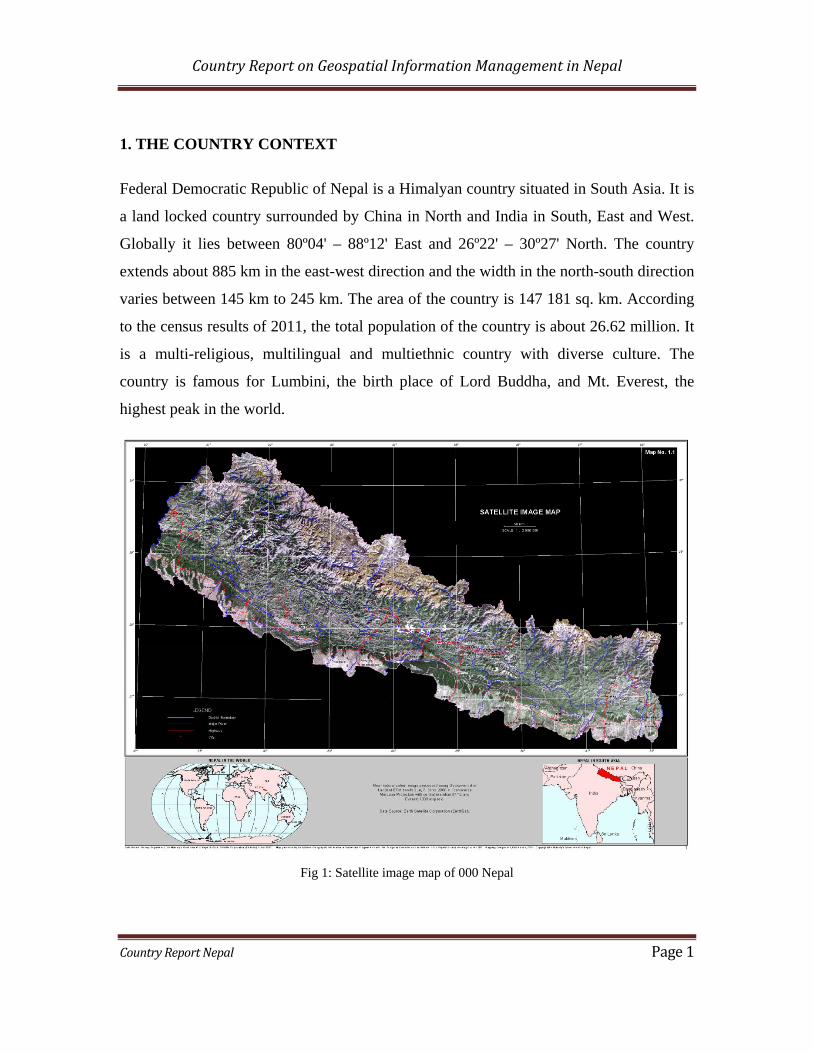
Federal Democratic Republic of Nepal is a Himalyan country situated in South Asia. It is
a land locked country surrounded by China in North and India in South, East and West.
Globally it lies between 80º04' – 88º12' East and 26º22' – 30º27' North. The country
extends about 885 km in the east-west direction and the width in the north-south direction
varies between 145 km to 245 km. The area of the country is 147 181 sq. km. According
to the census results of 2011, the total population of the country is about 26.62 million. It
is a multi-religious, multilingual and multiethnic country with diverse culture. The
country is famous for Lumbini, the birth place of Lord Buddha, and Mt. Everest, the
highest peak in the world.
Fig 1: Satellite image map of 000 Nepal
Country Report on Geospatial Information Management in Nepal
Country Report Nepal Page 2
Geographically, the country has diverse landscape. The elevation ranges almost from 60
m up to the top of the Mt. Everest, 8848 m. Out of world's 14 highest mountain peaks
(above 8,000 m), eight mountain peaks are located in it, including the Mt. Everest and the
third highest peak Mt. Kanchanjungha (8586 m). The country also has incredible touristic
destinations.
2. NATIONAL MAPPING ORGANIZATION IN GEOSPATIAL INFORMATION
SECTOR
2.1 Introduction
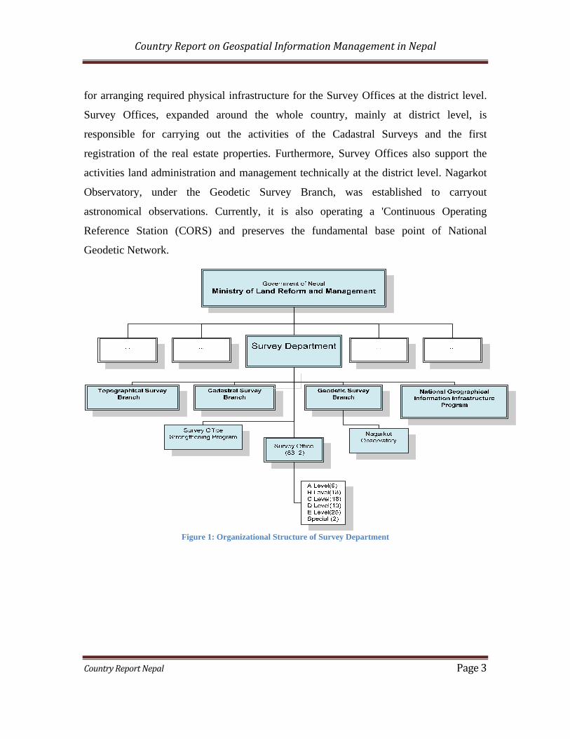
Survey Department, under the Ministry of Land Reform and Management, is the National
Mapping Organization (NMO) of Nepal. The Department was established in 1957. It is
the core organization working in the production, dissemination, and regulation of
geospatial information in the country.
The Department comprises of mainly three divisions namely Cadastral Survey Branch,
Geodetic Survey Branch and Topographical Survey Branch, and 83 Survey Offices.
National Geographic Information Infrastructure Project (NGIIP) and Survey Office
Strengthening Program are the other two wings of the Department working on project
basis. The organizational structure is as shown in Figure 1.
Topographical Survey Branch is responsible for producing and disseminating various
kinds of geospatial products including national topographic map series and administrative
maps. Geodetic Survey Branch is responsible for carrying out geodetic and astronomical
surveys, such as establishment of the national network of horizontal control points,
leveling survey, gravity survey, magnetic surveys, among others. Cadastral Survey Brach
is responsible for supervising the activities related to cadastral surveys and the first
registration of real estate properties in the country. National Geographic Information
Infrastructure Project was established as an initiative for National Spatial Data
Infrastructure (NSDI) in the country. Survey Office Strengthening Program is responsible
Country Report on Geospatial Information Management in Nepal
Country Report Nepal Page 3
for arranging required physical infrastructure for the Survey Offices at the district level.
Survey Offices, expanded around the whole country, mainly at district level, is
responsible for carrying out the activities of the Cadastral Surveys and the first
registration of the real estate properties. Furthermore, Survey Offices also support the
activities land administration and management technically at the district level. Nagarkot
Observatory, under the Geodetic Survey Branch, was established to carryout
astronomical observations. Currently, it is also operating a 'Continuous Operating
Reference Station (CORS) and preserves the fundamental base point of National
Geodetic Network.
Figure 1: Organizational Structure of Survey Department

Country Report on Geospatial Information Management in Nepal
Country Report Nepal Page 4
2.2 Role of Survey Department, as the National Mapping Organization
a) As a producer of Geospatial Information
The Department was mainly involved in cadastral surveying at the initial stages of its
establishment. The scope of the Department has been widened in greater scale over the
years. Currently, it has been involving in many segments of surveying and mapping such
as topographic mapping, geodetic surveys, ortho-photo map production, cadastral
surveys, land resources mapping etc. It applies modern technologies including remote
sensing, Photogrammetry, Global Navigation Satellite System, Digital Cadastre, among
others, for surveying and mapping activities of its mandate.
A new series of topographic base-maps were produced during 1992-2001. Based on the
new series of topographic maps at two basic scales; 1:25,000 for the plains and the
middle mountain region, and 1:50,000 for the high mountain and Himalayas. The
topographic maps series has been converted to the National Topographic Database
(NTDB). Currently, the department is working on the updating the topographic map
series. The department produced various kinds of land resource maps including land use
maps, land system maps, land capability maps and geological maps, during late 1970s
and early 1980s.
Various activities of geodetic surveys were carried out over the past 30 years. A geodetic
control network has been established throughout the country. Gravity observation,
geodetic leveling and measurements of previously established geodetic control points
with the Global Positioning System are its present activities. Recently, airborne gravity
survey have been conducted to determine the national geoid of the country.
The Department is successful to attain the nationwide coverage of cadastral survey in
1995. Leaving some densely populated settlement areas called as Village Blocks, each of
the parcels legally occupied has been brought under the cadastral system of the country.
Currently, cadastral surveys of several districts have been undertaken to re-survey the
districts that were surveyed in the past without using geodetic control.

Country Report on Geospatial Information Management in Nepal
Country Report Nepal Page 5
b) As a disseminator of Geospatial Information
As mentioned above, Survey Department has produced various kinds of geospatial
information products. Currently, the department is in a position to provide such
geospatial products, including control points, aerial photographs, topographical maps,
land resource maps, and cadastral data to government and private organizations useful for
any kind of development, and research and planning activities. The dissemination of the
geospatial products is done in analogue as well as in digital format. The Department
charges nominal fees for the data. Availability of the geospatial data has not been
restricted in the country except for few topographic maps.
c) As a nodal authority for National Spatial Data Infrastructure
Survey Department has undertaken an initiative for establishing national spatial data
infrastructure in the country since 2001. National Geographic Information Infrastructure
Project (NGIIP) is responsible for such activities. The project is making its best effort to
bring all the stakeholders including governmental, non-governmental and private sector
organizations working in the field of geospatial information in its network. The
Department has still to work hard for achieving expected progress in this sector, though.
d) As a regulatory body of Geospatial Industry
In recent years, the Department is gradually changing its role of providing surveying and
mapping services in the country to assuming a lead role in regulating the national
surveying and mapping activities. The Land (Surveying and Mapping) Act, 1963 and
corresponding Regulations 2001, have mandated the Department to issue surveying and
mapping license to the professionals, individuals as well as organization, endorse
technical specifications for any kind of surveying and mapping activities carried out
through public fund, and control the unauthorized production of geospatial data.
Country Report on Geospatial Information Management in Nepal
Country Report Nepal Page 6
Furthermore, the Department is the secretariat of the National Mapping Committee, that
has been formed for regulating all the surveying and mapping activities in the country.
All the geospatial products produced in the country, by any government or private
organization should get endorsed by the committee. The Director General of the
Department holds the position of the Member secretary of the committee and Coordinator
of the Technical Sub-committee.
3. OTHER ORGANIZATIONS INVOLVING IN GEOSPATIAL INFORMATION
SECTOR
A number of organizations like the Department of Forest Research and Survey, the
Department of Hydrology and Meteorology, the Department of Water Induced Disaster
Prevention, the National Planning Commission, Nepal Electricity Authority, the
International Centre for Integrated Mountain Development (ICIMOD), the International
Union for Conservation of Nature (IUCN) etc. are the major users of geospatial
information. Therefore, these organizations are somehow being involved in the
production of geospatial information by themselves in a condition that the products
follow the specification approved by the Department and connected to the national
geodetic network.
4. HUMAN RESOURCE DEVELOPMENT
The aspect of human resource development in the sector of geospatial information is not
very much optimistic in Nepal. The opportunity of university education in the country, in
this sector, began since a couple of year back only. Kathmandu University and
Purbanchal University are the two universities offering such opportunities whereas
Tribhuwan University is going to offer such opportunity from the coming session.
Previously, Land Management Training Center (then Survey Training Center) under the
Ministry of Land Reform and Management, was the only organization that used to
Country Report on Geospatial Information Management in Nepal
Country Report Nepal Page 7
produce human resources in this sector through various level of trainings, and the center
is continuingly doing so in present days too. Until now, no any opportunity of post
graduate studies is available in the country.
5. CHALLENGES OF THE GEOSPATIAL INFORMATION SECTOR IN NEPAL
Various challenges exist in Nepal in the sector of Geospatial information. Major
challenges in the sector can be listed out as follows:
National Mapping Organization of the country is lacking sufficient resources that
would be required to meet the national need in the sector of geospatial
information.
The opportunities for pursuing research studies and human resource development
in the sector are very rare in the country.
There is lack of sufficient and adequately trained human resource to work with
modern technology; and
The information sharing mechanism is not sufficiently adequate and the
willingness of the stakeholders in participating in the NSDI initiatives is not
optimistic.
===