Embed Size (px)
Citation preview

35Bulletin of the Chinese Academy of Sciences
InFocusVol.27 No.1 2013
New Chains of Space Weather Monitoring Stations in China
WANG Chi*
* This article was first published as the cover story of Issue 3, Volume 7 of Space Weather Quarterly in August 2010 (doi: 10.1029/2010SW000603). Prof. WANG Chi is a research professor at the National Space Science Center (NSSC, formerly the Center for Space Science and Applied Research), Chinese Academy of Sciences, and director of the State Key Laboratory of Space Weather at NSSC. He is also the chief engineer of the Chinese Meridian Project (e-mail: [email protected]).
To develop an understanding of near-Earth space’s response to solar activities and to eventually enhance the success of space weather predictions,
it is crucial to make synergetic observations of the entire environment from the Sun to the Earth as a system. Since the beginning of the space era, direct observations by satellites have become a much needed means toward this end. However, ground-based observations also have advantages and serve as a counterpart to those made in space. For example, instruments on the ground are much less expensive and easier to repair than those on satellites. Ground-based observations provide continuous high-resolution data not subject to the limitation of the downlink data rate from satellites to ground receiving stations. Also, because some observations have been made from Earth for hundreds of years, society has long and continuous records of quantities such as geomagnetic field variations, measurements of relative ionospheric opacity, and sunspot observations. Data from spacecraft, on the other hand, go back only a few decades.
China has a total land area of about 9,600,000 square kilometers, with geomagnetic locations covering middle to low latitudes. The first geomagnetic observatory in China was constructed in Beijing in 1870 by Russians, but it ceased working in 1882. China briefly participated in the International Geophysical Year (1957–1958) and started to explore the upper atmosphere using rockets and balloons in the 1960s. Though research at government institutions
and universities picked up in the late twentieth century, the ability to monitor the geospace environment and capture the evolution and characteristics of the weather in geospace above China is still insufficient today. Not only is China’s large population increasingly reliant on space-based technologies, but there are also not enough locations across the country where space weather conditions are monitored. This limits Chinese scientists’ understanding of the basic physical processes in geospace and their ability to make accurate predictions of adverse space weather for their country’s citizens.
To acknowledge the needs of both basic science and useful space weather operations, a ground-based program to monitor China’s geospace environment is currently under way. Called the Meridian Space Weather Monitoring Project (or Chinese Meridian Project), the effort consists of a chain of 15 ground-based observatories located roughly along 120°E longitude and 30°N latitude. Each observatory is equipped with multiple instruments to measure key parameters such as the baseline and time-varying geomagnetic field, as well as the middle and upper atmosphere and ionosphere from about 20 to 1000 kilometers. Starting in 2011, the project will collect data for at least 11 years, providing the wide-range, continuous, and multiparameter data sets needed to guide model developments, which in turn will better describe and predict the characteristics and dynamics of the geospace environment.
36 Bulletin of the Chinese Academy of Sciences
BCAS Vol.27 No.1 2013
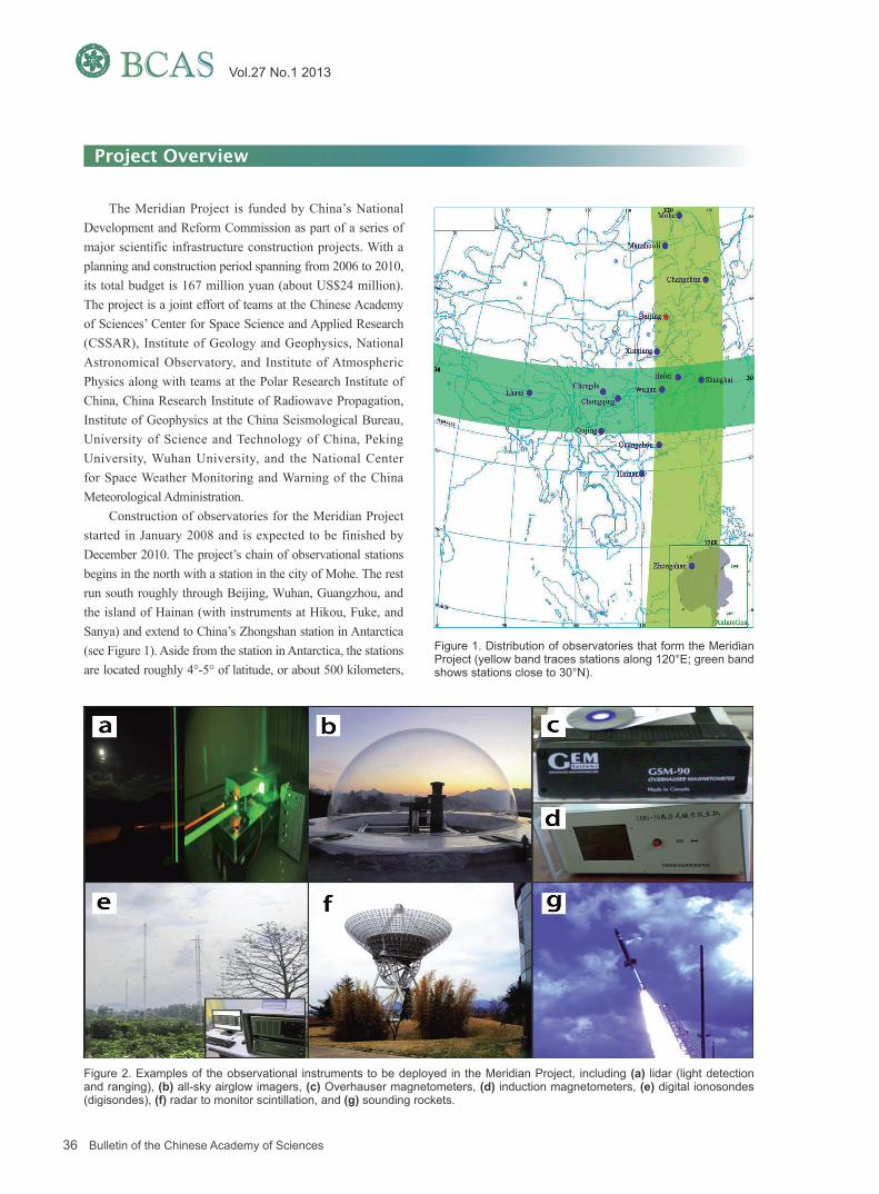
The Meridian Project is funded by China’s National Development and Reform Commission as part of a series of major scientific infrastructure construction projects. With a planning and construction period spanning from 2006 to 2010, its total budget is 167 million yuan (about US$24 million). The project is a joint effort of teams at the Chinese Academy of Sciences’ Center for Space Science and Applied Research (CSSAR), Institute of Geology and Geophysics, National Astronomical Observatory, and Institute of Atmospheric Physics along with teams at the Polar Research Institute of China, China Research Institute of Radiowave Propagation, Institute of Geophysics at the China Seismological Bureau, University of Science and Technology of China, Peking University, Wuhan University, and the National Center for Space Weather Monitoring and Warning of the China Meteorological Administration.
Construction of observatories for the Meridian Project started in January 2008 and is expected to be finished by December 2010. The project’s chain of observational stations begins in the north with a station in the city of Mohe. The rest run south roughly through Beijing, Wuhan, Guangzhou, and the island of Hainan (with instruments at Hikou, Fuke, and Sanya) and extend to China’s Zhongshan station in Antarctica (see Figure 1). Aside from the station in Antarctica, the stations are located roughly 4°-5° of latitude, or about 500 kilometers,
Project Overview
Figure 1. Distribution of observatories that form the Meridian Project (yellow band traces stations along 120°E; green band shows stations close to 30°N).
Figure 2. Examples of the observational instruments to be deployed in the Meridian Project, including (a) lidar (light detection and ranging), (b) all-sky airglow imagers, (c) Overhauser magnetometers, (d) induction magnetometers, (e) digital ionosondes (digisondes), (f) radar to monitor scintillation, and (g) sounding rockets.

37Bulletin of the Chinese Academy of Sciences
InFocusVol.27 No.1 2013
Table 1. Meridian Project Station Locations, Along With the Types of Observations and Instruments Deployed at Each
magnetometer, ionosonde
magnetometer, digisonde, TECa monitor/ ionospheric scintillation monitor
magnetometer, ionosonde
magnetometer, ionosonde
magnetometer, digisonde, lidarb, all-sky imager, Fabry-Perot interferometer, mesosphere-
stratosphere-thermosphere radar, interplanetary scintillation monitor, cosmic ray monitor, TEC
monitor/ ionospheric scintillation monitor, high-frequency Doppler frequency shift monitor
magnetometer, ionosonde, TEC monitor/ ionospheric scintillation monitor
lidar
magnetometer, digisonde, lidar, mesosphere-stratosphere-thermosphere radar, meteor radar, TEC monitor/ ionospheric scintillation monitor, high-frequency Doppler frequency shift monitor
magnetometer, ionosonde, cosmic ray monitor, TEC monitor/ionospheric scintillation monitor
magnetometer, digisonde, TEC monitor/ ionospheric scintillation monitor, lidar, all-sky imager, very high frequency radar, sounding
rockets, meteor radar
magnetometer, digisonde, high-frequency coherent scatter radar, aurora spectrometer
magnetometer, TEC monitor
magnetometer, ionosonde
magnetometer, ionosonde
incoherent scatter radar
InstrumentsLongitudeStation Latitude
Mohe
Manzhouli
Changchun
Beijing
Xinxiang
Hefei
Wuhan
Guangzhou
Hainan
Zhongshan
Shanghai
Chongqing
Chengdu
Qujing
Lhasa
53.5°N
49.6°N
44.0°N
40.3°N
34.6°N
33.4°N
30.5°N
23.1°N
19.0°N
69.4°S
31.1°N
29.5°N
31.0°N
25.6°N
29.6°N
122.4°E
117.4°E
125.2°E
116.2°E
113.6°E
116.5°E
114.6°E
113.3°E
109.8°E
76.4°E
121.2°E
106.5°E
103.7°E
103.8°E
91.0°E
a Total electron content.b Light detection and ranging.

39Bulletin of the Chinese Academy of Sciences
InFocusVol.27 No.1 2013
The ionosphere and upper atmosphere are parts of a coupled system that often dramatically changes in some space weather conditions. To monitor these changes, instruments at the Meridian Project’s stations will beam radio waves through the atmosphere into the ionosphere. The ionospheric plasma and atmospheric medium can affect radio beam propagation, causing reflection, refraction, and scattering. This allows scientists to measure ionospheric and upper atmospheric parameters by receiving the distorted echoes of radio signals; the magnitude of the distortion is an indicator of the quantity of free ions and particles through which the signal passed. Thus, scientists can monitor the changing density of charged particles, allowing them to better anticipate distortions to communications and navigation signals from satellites.
The most powerful instrument in the Meridian Project is an incoherent scatter radar, which will be located in Qujing, in Yunnan Province (25.6°N, 103.8°E). It will detect physical parameters of the ionosphere from 70 to 1000 kilometers, with a peak transmission power of 2 megawatts. Additionally, two mesosphere-stratosphere-troposphere radars, one in Beijing and
Using Radio Waves to Observe the Ionosphere
one in Wuhan, will make wind observations in the mesosphere, troposphere, and stratosphere with a wave frequency of about 50 megahertz. Continuous wind measurement in the mesopause region will also be made by a meteor radar at Wuhan. In addition, a high-frequency coherent scatter radar in Zhongshan station near the Amery Ice Shelf in East Antarctica will detect the motion of the ionospheric structure within an azimuth angle of 52° and a height of 3000 kilometers by receiving scatter echo from ionospheric irregularities.
A digisonde chain with instruments in Mohe, Beijing, Wuhan, Hainan, and Zhongshan will observe the electron profile within the altitudes that radio waves are reflected by the ionosphere’s F layer as well as monitor ionospheric plasma drift. In addition, real-time ionospheric TEC and scintillation monitors will also be deployed along the same chain (except in Zhongshan). Also, a high-frequency Doppler drift monitor chain will record the propagation of ionospheric disturbances at multiple scales through the use of a long-baseline system, including an array of three high-frequency Doppler antennas in Beijing and a monitor in Wuhan.
Sounding rockets are the only means to make in situ measurements of the temperature, density, wind field, and ionospheric electric field in the range of 20–200 kilometers. This region is beyond the capability of balloons and is too low for a satellite to maintain longtime operation, making rockets the best platform for collecting observations.
Measurements with Sounding Rockets
The sounding rocket launching base will be in Hainan, a low-latitude location. The scientific payloads include an atmospheric detecting package for measuring temperature, wind field, and density; a Langmuir probe for measuring the electron temperature, electron density, and electrical potential of plasma; and a gas analyzer for detecting micro-constituents in the atmosphere.
The Meridian Project is a multi-station and multi-instrument geospace environment monitoring network. Thus, a central data center is vital to collecting raw data in real time, turning the raw data into scientific data in accordance with international standards, archiving the data in a central data portal, and making them available to different users according to the data policy of the Meridian Project.
In principle, ordinary scientific data will be publicly available; the high-resolution data may be limited to the participating Chinese institutes and universities involved for a certain period of time. Further, specific high-resolution data sets may be exchanged with international users on a case-by-case basis.
The central data center will be in Beijing at China’s Center for Space Science and Applied Research (see Figure 3).
A Central Data Center
Figure 3. The Meridian Project’s (a) central data center and (b) science operation center, located in Beijing at the Center for Space Science and Applied Research (CSSAR).

40 Bulletin of the Chinese Academy of Sciences
BCAS Vol.27 No.1 2013
The Meridian Project is just one arm of a larger effort that Chinese scientists are proposing for the international community. This effort, called the International Space Weather Meridian Circle Program (ISWMCP), would connect 120°E and 60°W chains of ground-based monitors all over the world (mainly in Australia, Brazil, Canada, Russia, and the United States), which will enhance the ability of scientists to monitor the space environment worldwide.
The Meridian Project gives Chinese researchers a unique opportunity to contribute new capability for space weather predictions, both nationally and internationally. The synergies between the Meridian Project and satellite missions worldwide are essential for understanding geospace responses to interplanetary disturbances.
Located in Beijing, the Meridian Project’s Science Operation Center will be responsible for making short-, middle-, and long-term observational plans for the Meridian Project. CSSAR and Wuhan University will place more emphasis on middle to upper atmospheric modeling, while the Chinese Academy of Sciences’ Institute of Geology and Geophysics and the China Research Institute of Radiowave Propagation have been developing both empirical and physics-based ionospheric models. The Polar Research Institute of China will focus on modeling magnetosphere-ionosphere coupling. In addition, the State Key Laboratory of Space Weather at CSSAR and the University of Science and Technology of China are developing independent three-dimensional solar coronal – interplanetary
Toward Space Weather Modeling and Predictions
magnetohydrodynamic models and global magnetospheric magnetohydrodynamic models.
The Meridian Project will help supply data for China’s space weather integrated model (SWIM), an effort similar to the United States’ Center for Integrated Space Weather Modeling (CISM) and Center for Space Environment Modeling (CSEM). Through SWIM, data from the Meridian Project will be combined with data from China’s National Astronomical Observatory, which predicts solar activity. The better space weather models that will result from SWIM will be translated into operational frameworks though the Laboratory for Space Environment Research and Forecast at CSSAR, which provides space weather forecasts for Chinese manned flight missions and Chinese lunar missions. Operational frameworks will also be facilitated through the National Centre for Space Weather Monitoring and Warning at the China Meteorological Administration, which provides space weather services to the general public, and Chinese weather satellites.
Toward International Collaborations
The main purpose of ISWMCP would be to coordinate observations and share data among stations along the meridian to obtain the most scientific benefit for the global space weather community. No great circle-wide effort has been attempted before. ISWMCP is in its early stages – several discussions with other countries about how to proceed with this effort are currently under way.