Embed Size (px)
Citation preview
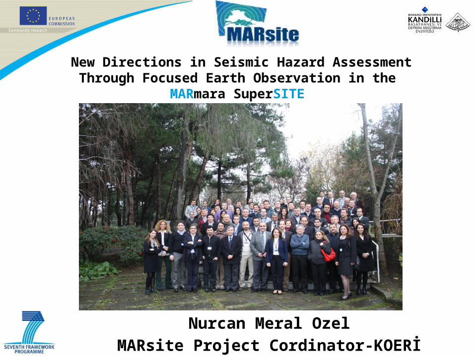
New Directions in Seismic Hazard Assessment Through Focused Earth Observation in the
MARmara SuperSITE
Nurcan Meral OzelMARsite Project Cordinator-KOERİ
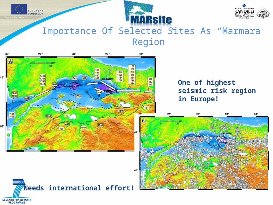
Importance Of Selected Sites As “Marmara Region”
One of highest seismic risk region in Europe!
Needs international effort!
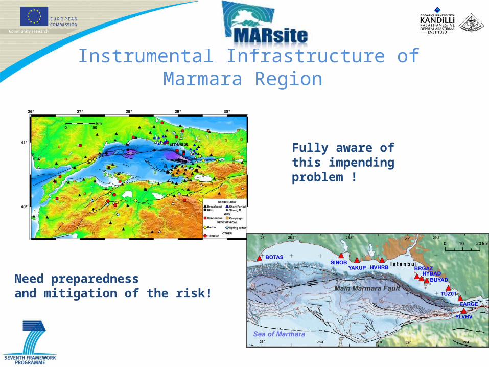
Instrumental Infrastructure of Marmara Region
Fully aware of this impending problem !
Need preparedness and mitigation of the risk!

The locations of Sea Bottom Observation System in the Marmara Region
Starting date: November 1, 2012Duration: 3 yearsManaging Team:Nurcan Meral Ozel, KOERI, Turkey (Coordinator)Ocal Necmioglu, KOERI, Turkey (Coordinator Assistant)Meral Alguadis (Project Manager)EC Scientific Officer:Efthimios ZAGORIANAKOS, DGDeliverable: 61 Milestone : 7 Total budget: 7,769,608.60EU funding: 5,965,286.45 EUR
New Directions in Seismic Hazard Assessment Through Focused Earth Observation in the
MARmara SuperSITE
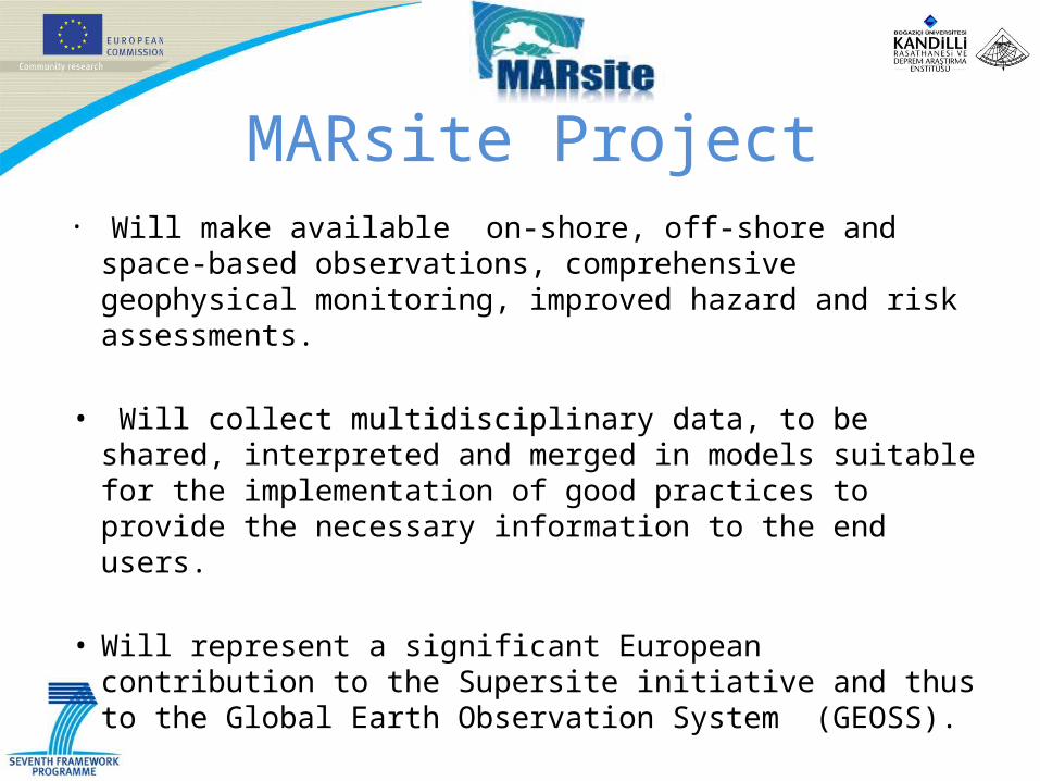
MARsite Project• Will make available on-shore, off-shore and space-based
observations, comprehensive geophysical monitoring, improved hazard and risk assessments.
• Will collect multidisciplinary data, to be shared, interpreted and merged in models suitable for the implementation of good practices to provide the necessary information to the end users.
• Will represent a significant European contribution to the Supersite initiative and thus to the Global Earth Observation System (GEOSS).
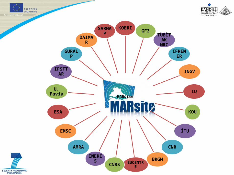
MARsite
KOERIGFZ
TÜBİTAK MRC
IFREMER
INGV
IU
KOU
İTU
CNR
BRGMEUCENTRECNRS
INERIS
AMRA
EMSC
ESA
U. Pavia
IFSTTAR
GÜRALP
DAIMAR
SARMAP
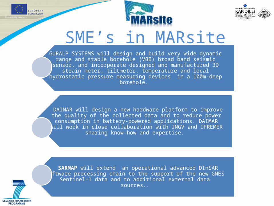
GURALP SYSTEMS will design and build very wide dynamic range and stable borehole (VBB) broad band seismic sensor, and incorporate designed and
manufactured 3D strain meter, tiltmeter, temperature and local hydrostatic pressure measuring devices in a 100m-deep borehole.
DAIMAR will design a new hardware platform to improve the quality of the collected data and to reduce power consumption in battery-powered
applications. DAIMAR will work in close collaboration with INGV and IFREMER sharing know-how and expertise.
SARMAP will extend an operational advanced DInSAR software processing chain to the support of the new GMES Sentinel-1 data and to additional external data
sources..
SME’s in MARsite
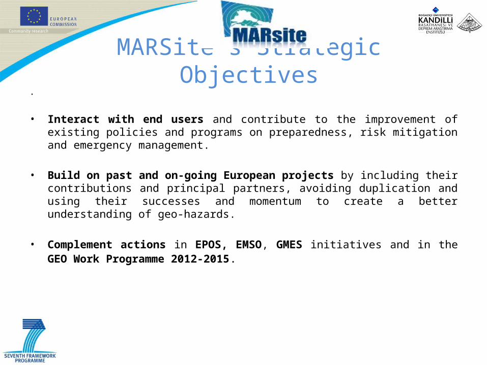
MARSite’s Strategic ObjectivesMARsite identifies a number of objectives that drive its implementation, the definition of the activities and the composition of the consortium. The MARsite strategic objectives are to:
• Achieve long-term hazard monitoring and evaluation by in-situ monitoring of: earthquakes, tsunamis, landslides, displacements, chemical-radioactive emission and other physical variables and; by the use of space-based techniques.
• Improve existing earthquake early-warning and rapid-response systems by involving common activities, participants, competences, knowledge and experts from Europe.
• Improve ground shaking and displacement modelling by development/updating of source models and the use of probabilistic and deterministic techniques with real-time and time-dependent applications.
• Contribute scientific and technical innovation by including state-of-the-art R&D in developing novel instruments and instrumentation.
MARSite’s Strategic Objectives.
• Interact with end users and contribute to the improvement of existing policies and programs on preparedness, risk mitigation and emergency management.
• Build on past and on-going European projects by including their contributions and principal partners, avoiding duplication and using their successes and momentum to create a better understanding of geo-hazards.
• Complement actions in EPOS, EMSO, GMES initiatives and in the GEO Work Programme 2012-2015.
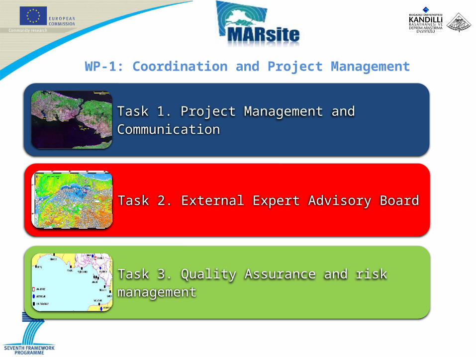
Task 1. Project Management and Communication
Task 2. External Expert Advisory Board
Task 3. Quality Assurance and risk management
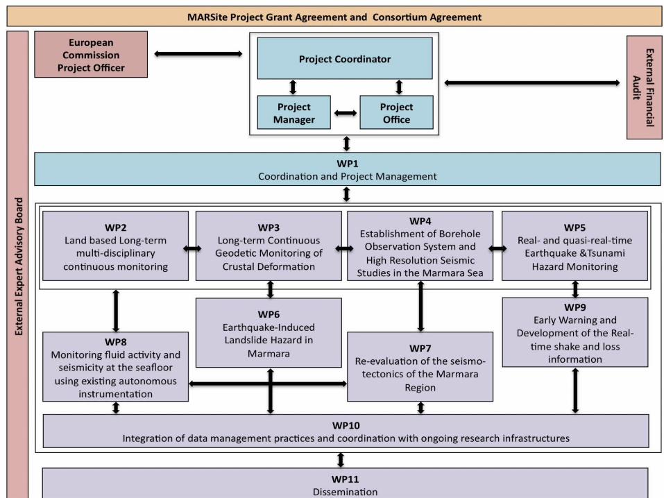
WP-1: Coordination and Project Management
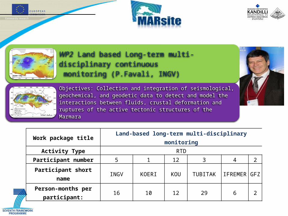
Work package title Land-based long-term multi-disciplinary monitoringActivity Type RTD
Participant number 5 1 12 3 4 2
Participant short name INGV KOERI KOU TUBITAK IFREMER GFZ
Person-months per participant:
16 10 12 29 6 2
WP2 Land based Long-term multi-disciplinary continuous monitoring (P.Favali, INGV)
Objectives: Collection and integration of seismological, geochemical, and geodetic data to detect and model the interactions between fluids, crustal deformation and ruptures of the active tectonic structures of the Marmara
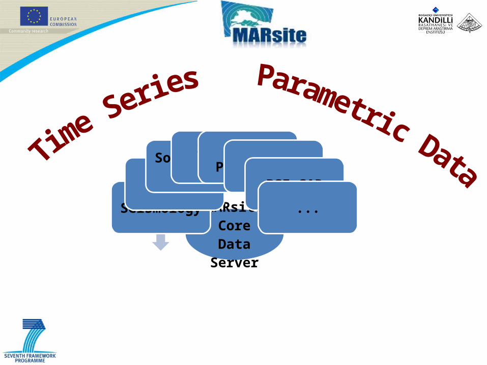
MARsiteCore Data
Server
Seismology
GPS
Soil Radon GasSpring WaterFluid Pressure
TiltPSInSAR
...
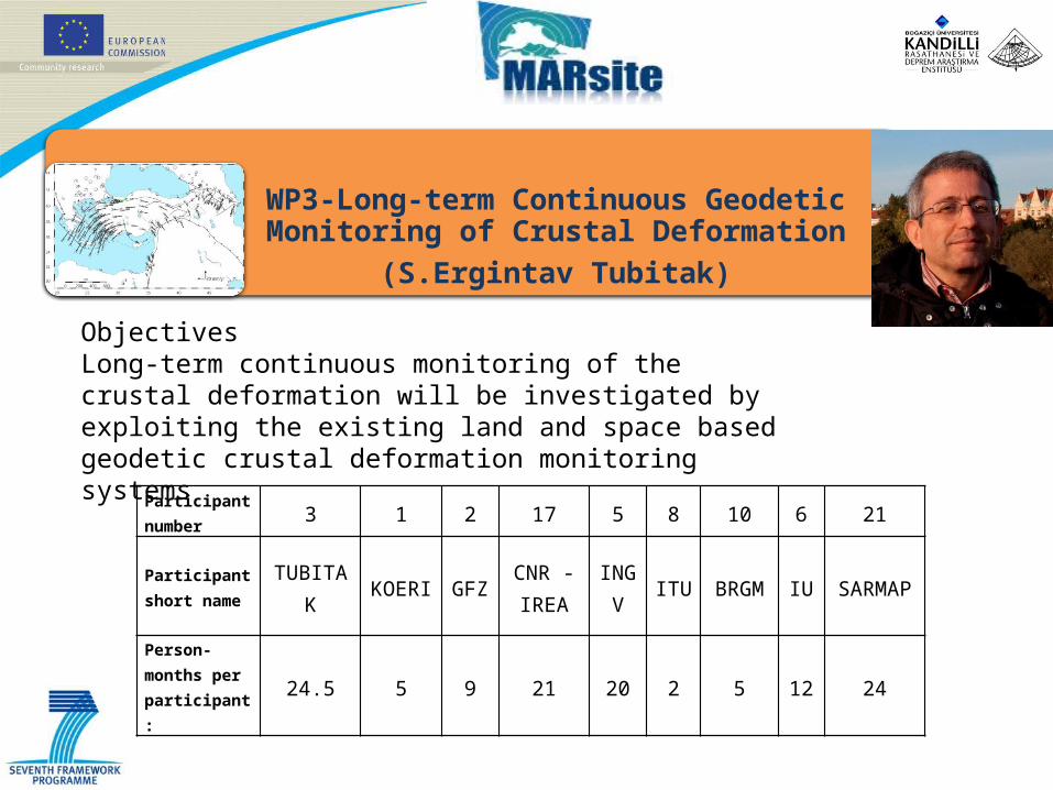
Participant number 3 1 2 17 5 8 10 6 21
Participant short name
TUBITAK
KOERI GFZCNR -IREA
INGV
ITU BRGM IU SARMAP
Person-months per participant:
24.5 5 9 21 20 2 5 12 24
WP3-Long-term Continuous Geodetic Monitoring of Crustal Deformation
(S.Ergintav Tubitak)
ObjectivesLong-term continuous monitoring of the crustal deformation will be investigated by exploiting the existing land and space based geodetic crustal deformation monitoring systems
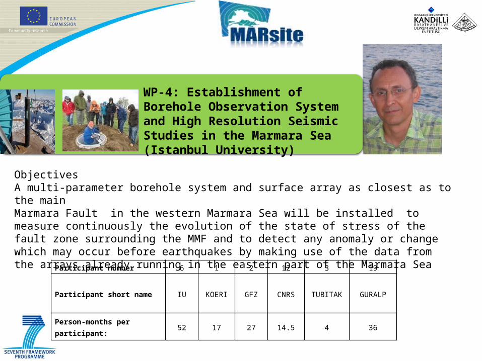
WP-4: Establishment of Borehole Observation System and High Resolution Seismic Studies in the Marmara Sea (Istanbul University)
Participant number 6 1 2 12 3 19
Participant short name IU KOERI GFZ CNRS TUBITAK GURALP
Person-months per participant: 52 17 27 14.5 4 36
ObjectivesA multi-parameter borehole system and surface array as closest as to the mainMarmara Fault in the western Marmara Sea will be installed to measure continuously the evolution of the state of stress of the fault zone surrounding the MMF and to detect any anomaly or change which may occur before earthquakes by making use of the data from the arrays already running in the eastern part of the Marmara Sea
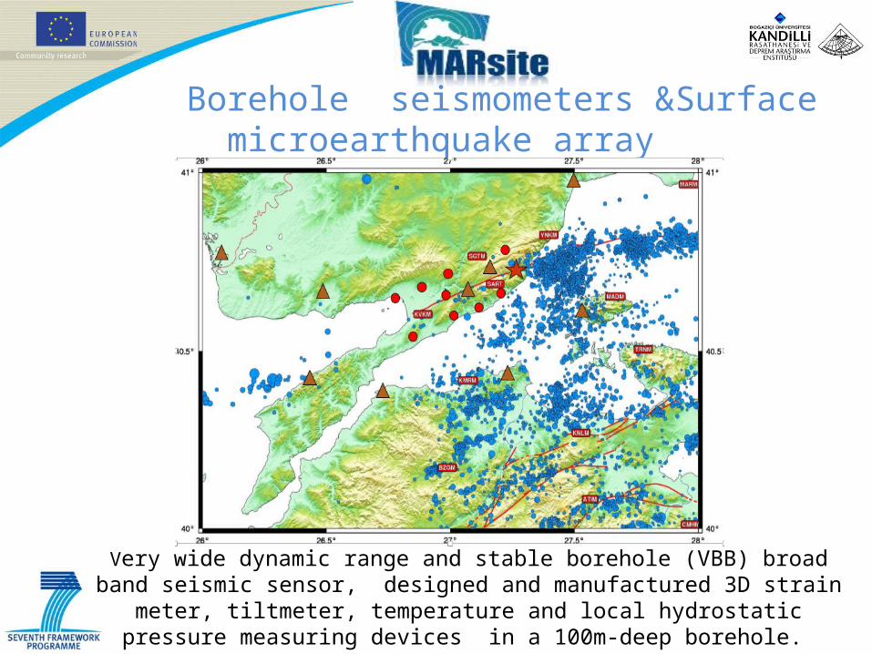
Borehole seismometers &Surface microearthquake array
Very wide dynamic range and stable borehole (VBB) broad band seismic sensor, designed and manufactured 3D strain meter, tiltmeter, temperature and local
hydrostatic pressure measuring devices in a 100m-deep borehole.
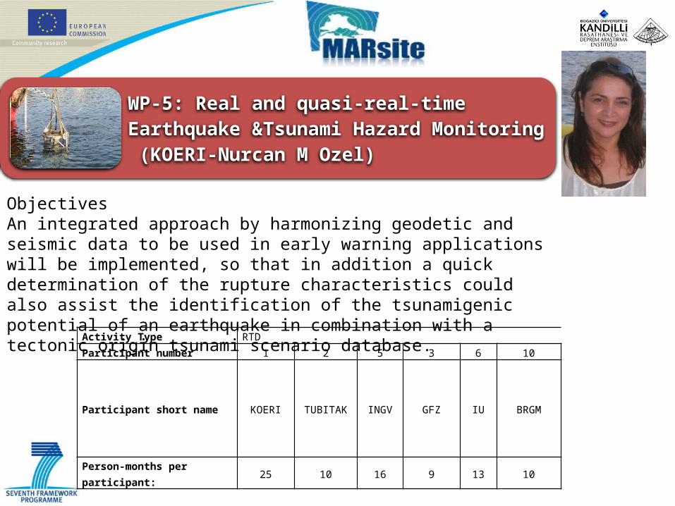
WP-5: Real and quasi-real-time Earthquake &Tsunami Hazard Monitoring (KOERI-Nurcan M Ozel)
Activity Type RTDParticipant number 1 2 5 3 6 10
Participant short name KOERI TUBITAK INGV GFZ IU BRGM
Person-months per participant: 25 10 16 9 13 10
ObjectivesAn integrated approach by harmonizing geodetic and seismic data to be used in early warning applications will be implemented, so that in addition a quick determination of the rupture characteristics could also assist the identification of the tsunamigenic potential of an earthquake in combination with a tectonic origin tsunami scenario database.
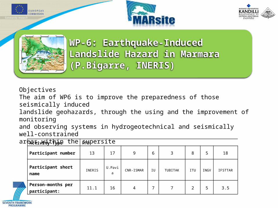
WP-6: Earthquake-Induced Landslide Hazard in Marmara (P.Bigarre, INERIS)
Activity Type RTD
Participant number 13 17 9 6 3 8 5 18
Participant short name INERIS U.Pavia CNR-ISMAR IU TUBITAK ITU INGV IFSTTAR
Person-months per participant:
11.1 16 4 7 7 2 5 3.5
ObjectivesThe aim of WP6 is to improve the preparedness of those seismically inducedlandslide geohazards, through the using and the improvement of monitoringand observing systems in hydrogeotechnical and seismically well-constrainedareas within the supersite
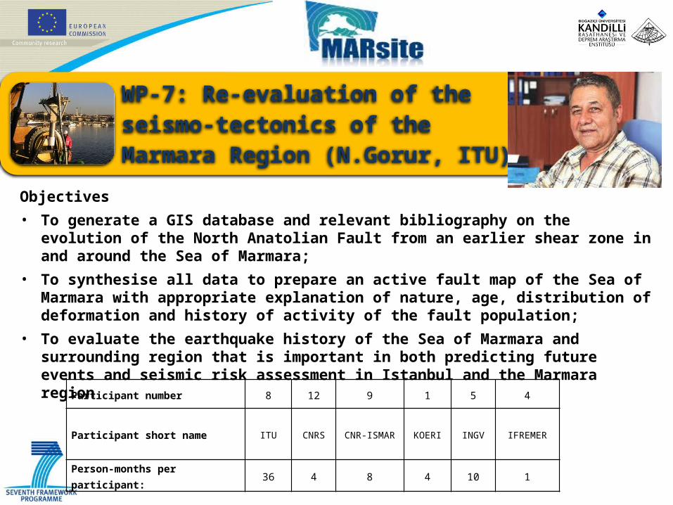
WP-7: Re-evaluation of the seismo-tectonics of the Marmara Region (N.Gorur, ITU)
Participant number 8 12 9 1 5 4
Participant short name ITU CNRS CNR-ISMAR KOERI INGV IFREMER
Person-months per participant: 36 4 8 4 10 1
Objectives
• To generate a GIS database and relevant bibliography on the evolution of the North Anatolian Fault from an earlier shear zone in and around the Sea of Marmara;
• To synthesise all data to prepare an active fault map of the Sea of Marmara with appropriate explanation of nature, age, distribution of deformation and history of activity of the fault population;
• To evaluate the earthquake history of the Sea of Marmara and surrounding region that is important in both predicting future events and seismic risk assessment in Istanbul and the Marmara region
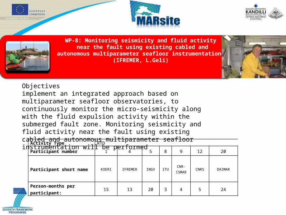
WP-8: Monitoring seismicity and fluid activity near the fault using existing cabled and autonomous
multiparameter seafloor instrumentation (IFREMER, L.Geli)
Activity Type RTD
Participant number 1 4 5 8 9 12 20
Participant short name KOERI IFREMER INGV ITUCNR-
ISMARCNRS DAIMAR
Person-months per participant: 15 13 20 3 4 5 24
Objectivesimplement an integrated approach based on multiparameter seafloor observatories, to continuously monitor the micro-seismicity along with the fluid expulsion activity within the submerged fault zone. Monitoring seismicity and fluid activity near the fault using existing cabled and autonomous multiparameter seafloor instrumentation will be performed
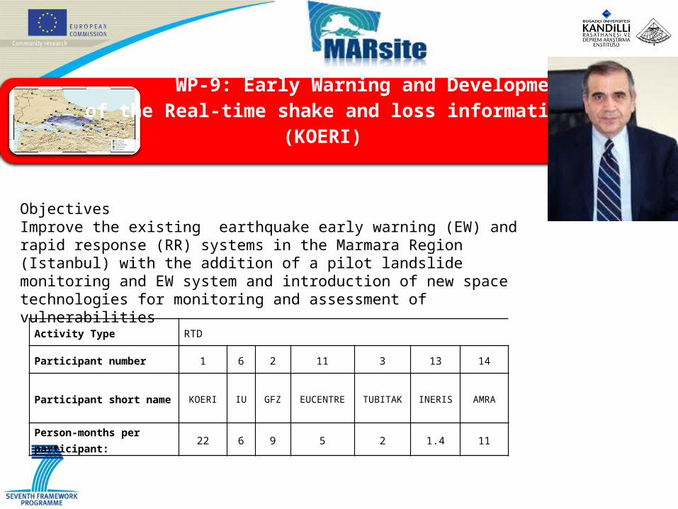
WP-9: Early Warning and Development
of the Real-time shake and loss information (KOERI)
Activity Type RTD
Participant number 1 6 2 11 3 13 14
Participant short name KOERI IU GFZ EUCENTRE TUBITAK INERIS AMRA
Person-months per participant:
22 6 9 5 2 1.4 11
ObjectivesImprove the existing earthquake early warning (EW) and rapid response (RR) systems in the Marmara Region (Istanbul) with the addition of a pilot landslide monitoring and EW system and introduction of new space technologies for monitoring and assessment of vulnerabilities

WP-10:Integration of data management practices and coordination with ongoing researchinfrastructures (BRGM, John Douglas)
Activity Type RTD
Participant number 10 5 16 1 3
Participant short name BRGM INGV ESA KOERI TUBITAK
Person-months per participant: 10 4 13 3 5
ObjectivesConcerns improving access to the wider community, outside the project consortium, of the data products and results of the project. This improved access concerns both dissemination of project results and conclusions to the general public and concerned stakeholders and also facilitating data access forthe technical community
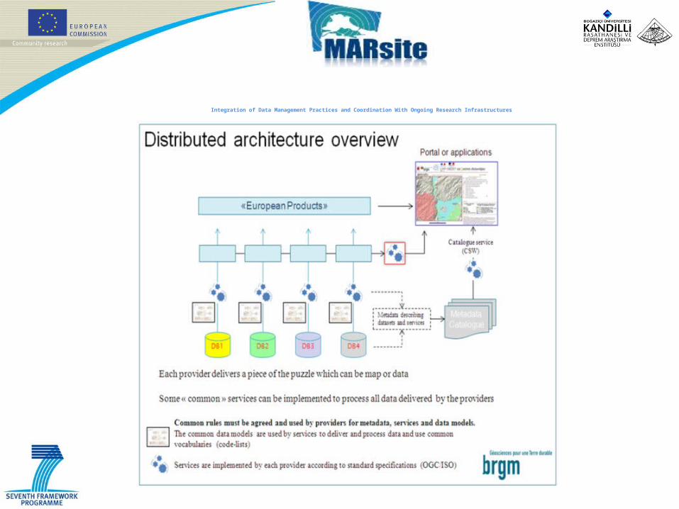
Integration of Data Management Practices and Coordination With Ongoing Research Infrastructures
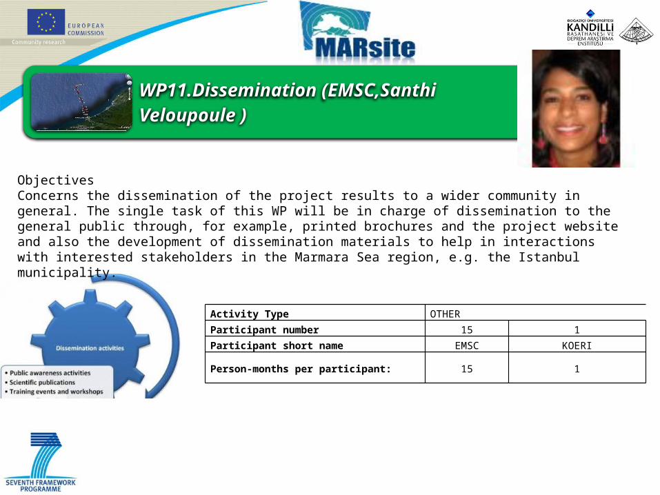
Activity Type OTHER Participant number 15 1Participant short name EMSC KOERI
Person-months per participant: 15 1
WP11.Dissemination (EMSC,Santhi Veloupoule )
ObjectivesConcerns the dissemination of the project results to a wider community in general. The single task of this WP will be in charge of dissemination to the general public through, for example, printed brochures and the project website and also the development of dissemination materials to help in interactions with interested stakeholders in the Marmara Sea region, e.g. the Istanbul municipality.

Budget
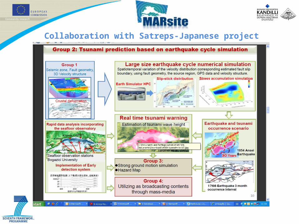
Collaboration with Satreps-Japanese project
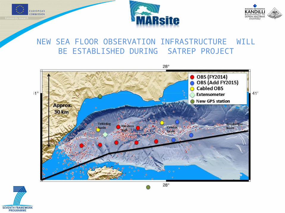
NEW SEA FLOOR OBSERVATION INFRASTRUCTURE WILL BE ESTABLISHED DURING SATREP PROJECT
MARSite’s Contribution to the Implementation of GEOSS and the GEO Tasks
- "lead to better scientific understanding of the geophysical processes" (Supersite Strategic Plan)
- "contribute in-situ data to a unifying e-infrastructure" (Supersite Strategic Plan)- "broaden our knowledge about geological extreme events" (Supersite White Paper)- "reduce our vulnerability to geologic hazards" (Supersite White Paper)
All the above is aimed at eventually: - "Mitigation of geological disasters" (Supersite Strategic Plan)- "Informing Risk Management and Disaster Reduction”- "Improved use of observations and related information to inform policies, decisions and actions
associated with disaster preparedness and mitigation." (GEOSS Strategic targets)- "Support to the successful implementation of the Hyogo Framework for Action 2005-2015"
(GEOSS Strategic targets)
MARSite’s Contribution to the Implementation of GEOSS and the GEO Tasks
• MARSite adopted the GEOSS philosopy and assigns special emphasis to the interoperability of the data and the results.
• WP10 as a dedicated work package to Data Integration is tasked with the liasion with the ongoing projects (such as Supersites initiatives) and will seek to reach agreements concerning standards.
• MARSite will define rules based on the recommendations defined in the Architecture and Data Committe of GEOSS to build and open architecture able to include new data providers, sensor information and services
supersites
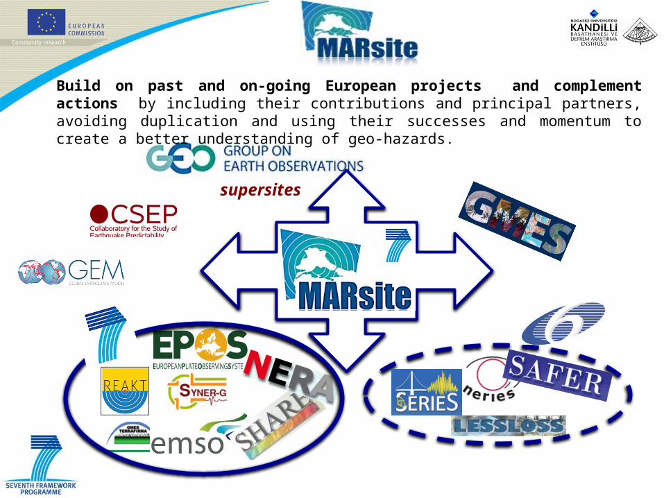
Build on past and on-going European projects and complement actions by including their contributions and principal partners, avoiding duplication and using their successes and momentum to create a better understanding of geo-hazards.
Thank you yThank you...
32
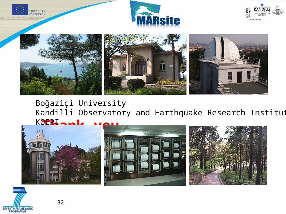
Boğaziçi UniversityKandilli Observatory and Earthquake Research Institute KOERI