Embed Size (px)
Citation preview
Churchill RiverPin
usRiver
Pin
us
Riv
er
Pinus River
�����
����� ��
�
��
�����
��
�����
�����������
����
������
�����
������
������
/
��
����
�
�����
���
������
���� �����
�������
��������
�������
�����
����
���
����������
�����
�����
�����
������
������
������
����
����
����
�������
��������
������
������
��������
������
��������
�����
������
�����
�����
�����
����������
�����
����������
�����
�����
�����
�����
�����
����� �������
����
�������
�������
������
�������
������
������
������
����
�����
����
����
����
�����
�
�����
����
����
����
����
����
��
����
��������
������
�����
������
����
�
��
�������
�
������� �
��
��
����
����
�����
��������
��������
����
����
�����
�����
�����
�������
����
����
��������
������
����
����
��
������
����������
�������
�� �
������
��
����������
����
����
�����
������
�����
�����
����
����
��������
��������
��������
�� ���
��
���������
�
���
���
����� �
�������
�������
�����
��
�
������
�������
������
������
�� �
�
����
���
����
�������
������
������
���
��
����������
�������
�����
�
�
������
��������
��������
�����
�����
������
�������
������
���������
�
��
��
�����
����
�����
�
��������������
�������� �
�����
��������
�����
����
��������
����������
�������
������
����
������
��
��������
��������
�����
������
����
�������
������
������
��������������
�����
���
�������� �����
�
���
�����
����
����
�������
����
�����
�������
���
��
�
�
� �� �
������
������
����
����
�
�������
����
���� �����
��
�������
�������
�������
�������
�
�
����
��
������
�����
�
������
������
��
��
�
������ �
�����
��������
��������
�������
�����������
���
����
����������
������
�
��������
�������
������
�����
�
�����
�������
����� �
��������
�������������
�
�������
����
������
������
���
������
�����
���������
��
����
�����
��������
����������
�
�����
�����
����
�������
��� �
��������
�����
�����
����
�����
������
�������
����
���������
�����
����
��������
����
������
�
�������
������
�
������
�
���������
������
� �
�������
�
�� ����
�������
�
�� �
����
�����
����
��������
�
�
����
����
������
������
���������������
��������
��������
�� ����
��������
��������
�����
��������
������
�����
��������
�����
���������
�����
�����
����
��������
� �
�����
�
������������
���
���
����������
�����
����
����
��������
�����
�����
������
�
������������
����������
������
����
������
���������
���������
���
���������
��������
������
�������
��������
����
��
���� �
���� �
����
�
�����
�
��������
�
�����
����
����
����
��������
��������
�������
������
�������
�����
�����
����������
���� ����
����
�
����
������
���
�����
��� �
�����
�
���
�������
��� ��
��� ��
������
�������
������� �
������� �
������ �
������
������
��
���� ��
������
�� ��
����������
��������
������
���������
�������
���
�������
����
������
����
��� ����
������
���
����
�
�������
�������
����
��������
������
�����
���������
����
������
������
��
���������������
�������
�������
�������� �����
�
�����
��
������
��������
������
����
�������
��������
�
�����
�
����
�������
��
��
����
������
�����
����
����
��
���� ������
�������
����������
���������
����� �
��
����
�������
��������
���������
����
������
��
�����
�����
�������
��
�
���
�
����������
�����
����
����������
��� ����
����������
����
�������
��
������
��
��
��
�
������������
������
������
������
����
��
�
�����
�����
�����
�����
����
��
�
�������
��
�����
����
����� ��
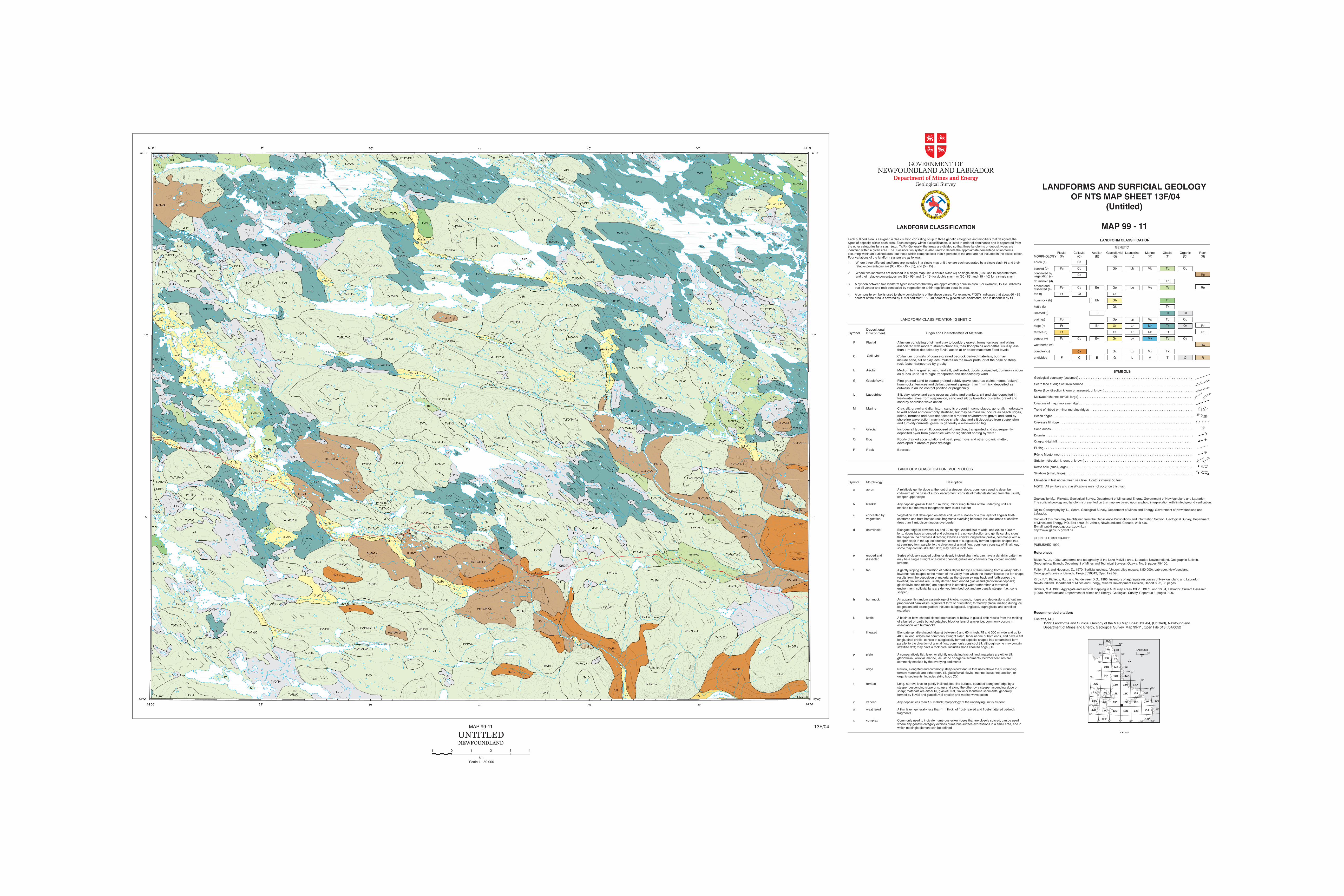
percent of the area is covered by fluvial sediment, 15 - 40 percent by glaciofluvial sediments, and is underlain by till.4. A composite symbol is used to show combinations of the above cases. For example, F/G(T) indicates that about 60 - 85
3. A hyphen between two landform types indicates that they are approximately equal in area. For example, Tv-Rc indicatesthat till veneer and rock concealed by vegetation or a thin regolith are equal in area.
and their relative percentages are (85 - 95) and (5 - 15) for double slash, or (60 - 85) and (15 - 40) for a single slash.2. Where two landforms are included in a single map unit, a double slash (//) or single slash (/) is used to separate them,
1. Where three different landforms are included in a single map unit they are each separated by a single slash (/) and theirrelative percentages are (60 - 85), (15 - 35), and (5 - 15) .
Each outlined area is assigned a classification consisting of up to three genetic categories and modifiers that designate thetypes of deposits within each area. Each category, within a classification, is listed in order of dominance and is separated fromthe other categories by a slash (e.g., Tv/R). Generally, the areas are divided so that three landforms or deposit types areidentified within a given area. The classification system is also used to denote the approximate percentage of landformsoccurring within an outlined area, but those which comprise less than 5 percent of the area are not included in the classification.Four variations of the landform system are as follows:
LANDFORM CLASSIFICATION
BedrockRockR
Poorly drained accumulations of peat, peat moss and other organic matter;developed in areas of poor drainage
BogO
Includes all types of till; composed of diamicton; transported and subsequentlydeposited by/or from glacier ice with no significant sorting by water
GlacialT
Clay, silt, gravel and diamicton; sand is present in some places, generally moderatelyto well sorted and commonly stratified, but may be massive; occurs as beach ridges,deltas, terraces and bars deposited in a marine environment; gravel and sand byshoreline wave action; may include shells, clay and silt deposited from suspensionand turbidity currents; gravel is generally a wavewashed lag
MarineM
Silt, clay, gravel and sand occur as plains and blankets; silt and clay deposited infreshwater lakes from suspension, sand and silt by lake-floor currents, gravel andsand by shoreline wave action
LacustrineL
Fine grained sand to coarse grained cobbly gravel occur as plains, ridges (eskers),hummocks, terraces and deltas; generally greater than 1 m thick; deposited asoutwash in an ice-contact position or proglacially
GlaciofluvialG
Medium to fine grained sand and silt, well sorted, poorly compacted; commonly occuras dunes up to 10 m high; transported and deposited by wind
AeolianE
Colluvium consists of coarse-grained bedrock derived materials, but mayinclude sand, silt or clay, accumulates on the lower parts, or at the base of steeprock faces; transported by gravity
ColluvialC
Alluvium consisting of silt and clay to bouldery gravel, forms terraces and plainsassociated with modern stream channels, their floodplains and deltas; usually lessthan 1 m thick; deposited by fluvial action at or below maximum flood levels
FluvialF
Origin and Characteristics of MaterialsSymbolDepositionalEnvironment
LANDFORM CLASSIFICATION: GENETIC
Commonly used to indicate numerous esker ridges that are closely spaced; can be usedwhere any genetic category exhibits numerous surface expressions in a small area, and inwhich no single element can be defined
complexx
fragmentsA thin layer, generally less than 1 m thick, of frost-heaved and frost-shattered bedrockweatheredw
Any deposit less than 1.5 m thick; morphology of the underlying unit is evidentveneerv
Long, narrow, level or gently inclined step-like surface, bounded along one edge by asteeper descending slope or scarp and along the other by a steeper ascending slope orscarp; materials are either till, glaciofluvial, fluvial or lacustrine sediments; generallyformed by fluvial and glaciofluvial erosion and marine wave action
terracet
Narrow, elongated and commonly steep-sided feature that rises above the surroundingterrain; materials are either rock, till, glaciofluvial, fluvial, marine, lacustrine, aeolian, ororganic sediments. Includes string bogs (Or)
ridger
A comparatively flat, level, or slightly undulating tract of land; materials are either till,glaciofluvial, alluvial, marine, lacustrine or organic sediments; bedrock features arecommonly masked by the overlying sediments
plainp
Elongate spindle-shaped ridge(s) between 6 and 60 m high, 75 and 300 m wide and up to4000 m long; ridges are commonly straight sided, taper at one or both ends, and have a flatlongitudinal profile; consist of subglacially formed deposits shaped in a streamlined formparallel to the direction of glacial flow; commonly consist of till, although some may containstratified drift; may have a rock core. Includes slope lineated bogs (Ol)
lineatedl
A basin or bowl-shaped closed depression or hollow in glacial drift; results from the meltingof a buried or partly buried detached block or lens of glacier ice; commonly occurs inassociation with hummocks
kettlek
An apparently random assemblage of knobs, mounds, ridges and depressions without anypronounced parallelism, significant form or orientation; formed by glacial melting during icestagnation and disintegration; includes subglacial, englacial, supraglacial and stratifiedmaterials
hummockh
A gently sloping accumulation of debris deposited by a stream issuing from a valley onto alowland; has its apex at the mouth of the valley from which the stream issues; the fan shaperesults from the deposition of material as the stream swings back and forth across thelowland; fluvial fans are usually derived from eroded glacial and glaciofluvial deposits;glaciofluvial fans (deltas) are deposited in standing water rather than a terrestrialenvironment; colluvial fans are derived from bedrock and are usually steeper (i.e., coneshaped)
fanf
Series of closely spaced gullies or deeply incised channels; can have a dendritic pattern ormay be a single straight or arcuate channel; gullies and channels may contain underfitstreams
eroded anddissected
e
Elongate ridge(s) between 1.5 and 20 m high, 20 and 300 m wide, and 200 to 5000 mlong; ridges have a rounded end pointing in the up-ice direction and gently curving sidesthat taper in the down-ice direction; exhibit a convex longitudinal profile, commonly with asteeper slope in the up-ice direction; consist of subglacially formed deposits shaped in astreamlined form parallel to the direction of glacial flow; commonly consists of till, althoughsome may contain stratified drift; may have a rock core
drumlinoidd
Vegetation mat developed on either colluvium surfaces or a thin layer of angular frost-shattered and frost-heaved rock fragments overlying bedrock; includes areas of shallow(less than 1 m), discontinuous overburden
concealed byvegetation
c
Any deposit greater than 1.5 m thick; minor irregularities of the underlying unit aremasked but the major topographic form is still evident
blanketb
A relatively gentle slope at the foot of a steeper slope, commonly used to describecolluvium at the base of a rock escarpment; consists of materials derived from the usuallysteeper upper slope
aprona
DescriptionMorphologySymbol
LANDFORM CLASSIFICATION: MORPHOLOGY
Tx
T
Mx
M
Lx
L
Gx
G
(x)complex
Rw
R
(w)weathered
undivided
Ov
O
TvMvLvGvEv
E
Cv
Cx
C
Fv
F
(v)veneer
RtTtMtLtGtFt(t)terrace
RrOrTrMrLrGrErFr(r)ridge
OpTpMpLpGpFp(p)plain
OlTlEl(l)lineated
TkGk(k)kettle
ThGhEh(h)hummock
GfCfFf(f)fan
ReTeMeLeGeEeCeFeeroded anddissected (e)
Td(d)drumlinoid
RcCcconcealed byvegetation (c)
ObTbMbLbGbCbFb(b)blanket
Ca(a)apron
(R)(O)(T)(M)(L)(G)(E)(C)(F)MORPHOLOGYRockOrganicGlacialMarineLacustrineGlaciofluvialAeolianColluvialFluvial
GENETIC
LANDFORM CLASSIFICATION
PUBLISHED 1999
OPEN FILE 013F/04/0052
Digital Cartography by T.J. Sears, Geological Survey, Department of Mines and Energy, Government of Newfoundland andLabrador.
Geology by M.J. Ricketts, Geological Survey, Department of Mines and Energy, Government of Newfoundland and Labrador.The surficial geology and landforms presented on this map are based upon airphoto interpretation with limited ground verification.
Copies of this map may be obtained from the Geoscience Publications and Information Section, Geological Survey, Departmentof Mines and Energy, P.O. Box 8700, St. John’s, Newfoundland, Canada, A1B 4J6.E-mail: [email protected]://www.geosurv.gov.nf.ca
Meltwater channel (small, large) . . . . . . . . . . . . . . . . . . . . . . . . . . . . . . . . . . . . . . . . . . . . . . . . . . . . . . . . . . . . . . . . .
Esker (flow direction known or assumed, unknown) . . . . . . . . . . . . . . . . . . . . . . . . . . . . . . . . . . . . . . . . . . . . . . . . . . .
Scarp face at edge of fluvial terrace . . . . . . . . . . . . . . . . . . . . . . . . . . . . . . . . . . . . . . . . . . . . . . . . . . . . . . . . . . . . . . .
Geological boundary (assumed) . . . . . . . . . . . . . . . . . . . . . . . . . . . . . . . . . . . . . . . . . . . . . . . . . . . . . . . . . . . . . . . . . .
SYMBOLS
� �� �
� �� �
�
����� ���
LANDFORMS AND SURFICIAL GEOLOGY
OF NTS MAP SHEET 13F/04
(Untitled)
MAP 99 - 11
GOVERNMENT OFNEWFOUNDLAND AND LABRADOR
Department of Mines and EnergyGeological Survey
GEO
LOGICAL SURVE
Y
NE
WF
OU
ND
LAN D ANDLA
BR
AD
OR
1864
v
Elevation in feet above mean sea level. Contour interval 50 feet.
Sand dunes . . . . . . . . . . . . . . . . . . . . . . . . . . . . . . . . . . . . . . . . . . . . . . . . . . . . . . . . . . . . . . . . . . . . . . . . . . . . . . . . . .
Beach ridges . . . . . . . . . . . . . . . . . . . . . . . . . . . . . . . . . . . . . . . . . . . . . . . . . . . . . . . . . . . . . . . . . . . . . . . . . . . . . . . . .
Sinkhole (small, large) . . . . . . . . . . . . . . . . . . . . . . . . . . . . . . . . . . . . . . . . . . . . . . . . . . . . . . . . . . . . . . . . . . . . . . . . . .
Rôche Moutonnée . . . . . . . . . . . . . . . . . . . . . . . . . . . . . . . . . . . . . . . . . . . . . . . . . . . . . . . . . . . . . . . . . . . . . . . . . . . . .
Striation (direction known, unknown) . . . . . . . . . . . . . . . . . . . . . . . . . . . . . . . . . . . . . . . . . . . . . . . . . . . . . . . . . . . . . .
Kettle hole (small, large) . . . . . . . . . . . . . . . . . . . . . . . . . . . . . . . . . . . . . . . . . . . . . . . . . . . . . . . . . . . . . . . . . . . . . . . .
Drumlin . . . . . . . . . . . . . . . . . . . . . . . . . . . . . . . . . . . . . . . . . . . . . . . . . . . . . . . . . . . . . . . . . . . . . . . . . . . . . . . . . . . . . .
Crevasse fill ridge . . . . . . . . . . . . . . . . . . . . . . . . . . . . . . . . . . . . . . . . . . . . . . . . . . . . . . . . . . . . . . . . . . . . . . . . . . . . .
Crag-and-tail hill . . . . . . . . . . . . . . . . . . . . . . . . . . . . . . . . . . . . . . . . . . . . . . . . . . . . . . . . . . . . . . . . . . . . . . . . . . . . . .
Fluting . . . . . . . . . . . . . . . . . . . . . . . . . . . . . . . . . . . . . . . . . . . . . . . . . . . . . . . . . . . . . . . . . . . . . . . . . . . . . . . . . . . . . .
Crestline of major moraine ridge . . . . . . . . . . . . . . . . . . . . . . . . . . . . . . . . . . . . . . . . . . . . . . . . . . . . . . . . . . . . . . . . . .
Trend of ribbed or minor moraine ridges . . . . . . . . . . . . . . . . . . . . . . . . . . . . . . . . . . . . . . . . . . . . . . . . . . . . . . . . . . . .
������ � � � � � � � � � �����
������ � � � � � � � � � �����
��
��
NOTE : All symbols and classifications may not occur on this map.
1999: Landforms and Surficial Geology of the NTS Map Sheet 13F/04, (Untitled), NewfoundlandDepartment of Mines and Energy, Geological Survey, Map 99-11, Open File 013F/04/0052
Ricketts, M.J.
Recommended citation:
References
Blake, W. Jr., 1956: Landforms and topography of the Lake Melville area, Labrador, Newfoundland. Geographic Bulletin,Geographical Branch, Department of Mines and Technical Surveys, Ottawa, No. 9, pages 75-100.
Fulton, R.J. and Hodgson, D., 1970: Surficial geology, (Uncontrolled mosaic, 1;50 000), Labrador, Newfoundland.Geological Survey of Canada, Project 690043; Open File 59.
Kirby, F.T., Ricketts, R.J., and Vanderveer, D.G., 1983: Inventory of aggregate resources of Newfoundland and Labrador.Newfoundland Department of Mines and Energy, Mineral Development Division, Report 83-2, 36 pages.
Rickets, M.J.,1998: Aggregate and surficial mapping in NTS map areas 13E/1, 13F/3, and 13F/4, Labrador. Current Research(1998), Newfoundland Department of Mines and Energy, Geological Survey, Report 98-1, pages 9-20.
24I
24A
13E
3D
24H
���
���
���
9
���
25A
24P 14M14M
14L
14E 14F
14C14C
13N
13K
13F
13C13D
13E
14D
13M
13L
13B
13G
13J
13O
23A
23H
23I
23B
23G
23J
23O
13A
12P
13H
13I
22P
53�
52�
LABRADOR
0 150
km
�� ����
�� ����
��� ��� ��� ��� ��� �� ����
�� ����
���
��
�� ����
�� ����
����������������� ����
�� ����
��
���
01 1 2 3 4
Scale 1 : 50 000
km
MAP 99-11 13F/04
UNTITLEDNEWFOUNDLAND
��
��
���
��
���
���
��
��
���
��
��
��