Embed Size (px)
Citation preview
1 of 29
Teranga Gold’s Drill Results Confirm Banfora Reserve Model and Potential for Reserve Expansion
Significant 15-month exploration program set to commence in Burkina Faso
(All amounts are in U.S. dollars unless otherwise stated)
Toronto, Ontario – October 26, 2016 - Teranga Gold Corporation ("Teranga" or the "Company") (TSX: TGZ) (ASX: TGZ) provided an update on its exploration activities in Burkina Faso, West Africa.
“We have just completed the first phase of a substantial exploration program undertaken to support our three growth objectives for the newly acquired Gryphon assets,” stated Paul Chawrun, Chief Operating Officer of Teranga. “The first objective is to confirm and increase the resource base of the Banfora gold project, which includes both a mine license with an area of 89km2 and a regional land package surrounding the mine license comprised of five exploration permits totaling 933km2. The second is to commence exploration programs at both Golden Hill and Gourma. The third and final objective is to complete an updated feasibility study by the end of the second quarter of 2017, which would put us on track for construction start-up in the second half of 2017 and production as early as 2019.” Added, Mr. Chawrun, “Commencing next month, extensive exploration programs are planned across our prospective exploration portfolio in Burkina Faso, Côte d’Ivoire and in Senegal, utilizing the combined experience and expertise of both the Teranga and Gryphon teams.”
HIGHLIGHTS
The recent drilling results have been favorable in confirming mineralisation in three of the four deposits defined by previous geological modeling through extension of high-grade shoots from infill drilling and potential expansion of the near-surface resource along strike and at depth in areas.
– At the Nogbele deposit, a minimum 200-metre strike extent of broad, shallow, oxide mineralisation has been confirmed at the Tahiti structure.
– Also at Nogbele, a new parallel zone to the Nogbele Central pit area demonstrates the potential for a 400-metre strike length of near surface oxide mineralisation.
– At the Fourkoura deposit, initial diamond core results are confirming the mineralisation defined by the previous geological models developed predominantly from reverse circulation (“RC”) drilling.
– At the Samavogo deposit, drilling has been successful in extending a zone of mineralisation in the central part of the deposit and outlining up-dip mineralisation in the south.
“The drill program results at our Banfora gold project are continuing to confirm mineralisation identified within the geological resource models in the areas of the reserve deposits(1) while step out drilling has shown continuity of several deposits both along strike and at depth, giving the potential to increase resources,” stated David Mallo, Vice President, Exploration. “While our primary focus up to this point has been on Nogbele, Samavogo, Stinger and Fourkoura, we are set to begin testing eleven advanced stage prospects within trucking distance of the proposed mill, which have the potential for reserve expansion.”
DRILLING UPDATE
A total of 6,000 metres of diamond core and 11,500 metres of RC drilling have been completed during the 2016 calendar year at the Banfora gold project, the majority of which was undertaken over the past three months.
News Release

2 of 29
The focus of this intensive drilling campaign was to explore strike extensions of mineralized zones, to add shallow oxide resource ounces, to test high-grade plunging shoots and to increase modeling confidence at the deposits comprising the upcoming feasibility study resource estimate. Results are being utilized in updating the geological models as well as deposit wireframes and will be incorporated into the new independent resource update due for delivery in second quarter 2017.
A partial program of confirmatory drilling has now been completed at three of the four deposits which comprised the January 31, 2013 Gryphon Feasibility Study(2): Nogbele, Samavogo and Fourkoura (see Figure 1 in Appendix 1). At the fourth deposit, Stinger, an independent detailed structural evaluation was undertaken to confirm the geologic model and to guide future drilling. It is expected that drilling will commence at Stinger in fourth quarter 2016.
In addition to the recently completed drilling campaign, considerable progress continues on updating and optimizing the January 31, 2013 Gryphon Feasibility Study. Updates will include a revised process design with updated capital and operating costs. Further metallurgical test work is ongoing to assist in the optimisation of the process design. An independent resource and reserves estimate, which is anticipated to be complete in second quarter 2017, will be included in an updated National Instrument 43-101 Technical Report. The new feasibility study will embed Teranga’s extensive operational and construction experience in West Africa.
All significant drill hole intersections are presented in Table 1 in Appendix 1.
Nogbele Deposit The recent drilling results at the Nogbele deposit (see Figure 2 in Appendix 1), the largest of the four deposits in the January 31, 2013 Gryphon Feasibility Study, have been favourable in confirming the geological resource model and identifying extensions along trend, including the Tahiti structure which is a minimum 200-metre strike extension to a broad shallow oxide zone (see Figures 3 & 4 in Appendix 1). Tahiti remains open to the northwest beyond drill hole BNDD3827 which intersected 1.82 g/t Au over 16m (66-82m).
Examples of the favorable drilling results from the recent drilling campaign at the Nogbele deposit:
2.48 g/t Au over 16m (12-28m) in Hole BNRC4840 including 22.5g/t Au over 1m (15-16m) 2.98 g/t Au over 9m (32-41m) in Hole BNRC4925 3.57 g/t Au over 6m (13-19m) in Hole BNRC4926 3.17 g/t Au over 6m (16-22m) in Hole BNRC4928 2.69 g/t Au over 29m (21-50m) in Hole BNDD3826 including 6.3g/t Au over 6m (42-48m) 1.82 g/t Au over 16m (66-82m) in Hole BNDD3827
1. True widths are unknown.
2. Intercept gold values are determined from uncapped assays.
Samavogo Deposit
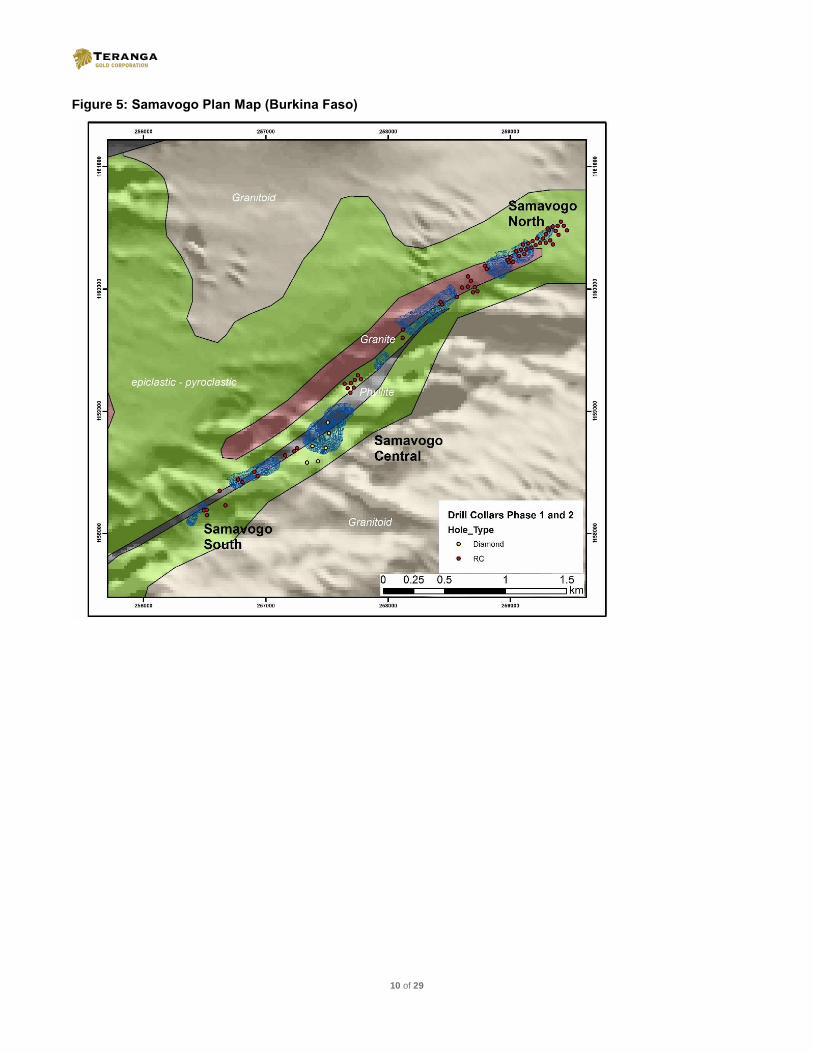
Recent drill results at the second largest deposit, Samavogo, have confirmed mineralization, outlined up-dip gold mineralization at the southern end of the deposit and successfully extended a mineralized zone in the central portion of the deposit (see Figure 5 in Appendix 1).

3 of 29
Examples of the favorable drilling results from the recent drilling campaign at Samavogo deposit:
3.28 g/t Au over 7m (62-69m) in Hole BNRC4853 3.93 g/t Au over 5m (34-39m) in Hole BNRC4862 3.15 g/t Au over 6m (82-88m) in Hole BNRC4873 5.46 g/t Au over 6m (106-112m) in Hole BNDD3831 5.52g/t Au over 14m (43-57m) in BNDD3833 including 11.00 g/t Au over 3m (43-46m)
1. True widths are unknown.
2. Intercept gold values are determined from uncapped assays. Fourkoura Deposit
Recent drilling at the Fourkoura deposit was predominantly diamond core designed to reinforce the geological model previously heavily weighted on RC results (see Figure 6 in Appendix 1). Results received to-date are providing confidence for the modeling and encouragement for potential near-surface strike extensions.
A step-out exploration hole 200 metres north of the Fourkoura deposit has successfully intersected anomalous gold mineralization within the same Gabbro-hosting shear zone as at Fourkoura. Follow-up drilling will be undertaken to substantiate this potential strike extension.
Examples of the favorable drilling results from the recent drilling campaign at Fourkoura deposit:
6.56 g/t Au over 4m (99-103m) in Hole BNRC4821 4.43 g/t Au over 3m (44-47m) in Hole BNRC4823 2.52 g/t Au over 6m (84-90m) in Hole BNDD3593 2.72 g/t Au over 6m (23-29m) in Hole BNDD3595 2.90 g/t Au over 12.4m (28-40.4m) in Hole BNDD3590
1. True widths are unknown.
2. Intercept gold values are determined from uncapped assays.
Additional Prospects Within Trucking Distance to the Proposed Mill
Outside of the current Banfora mine license, and within trucking distance to the proposed mill, there are eleven advanced prospects that have considerable upside potential.
Of these targets, the highest priority is the Ouahiri prospect (see Figure 7 in Appendix 1), which displays a similar geochemical footprint in both size (2.5km across) and tenor as that outlining the large Nogbele deposit. Very limited drilling to-date has intersected some favorable results requiring considerable follow-up evaluation. Auger, RC and diamond core drilling supported by ground geophysics to highlight the most favourable bedrock anomalism is expected to commence in fourth quarter 2016.
The remaining ten priority prospects at Banfora are to be systematically explored during the upcoming field season, including those along strike of the four deposits and in the under explored western half of Banfora, including Kafina West and Bagu Sud / Weah prospects where previous work has identified strong gold anomalism (see Figure 8 in Appendix 1).
Golden Hill (51%, Earn-in 80%) & Gourma (51%, Earn-in 80%)
Field work is scheduled to recommence at Golden Hill and Gourma during November 2016 with greater emphasis on the more advanced and prospective Golden Hill project.
As shown in Figure 9 in Appendix 1, Golden Hill is located on the Houndé Belt along strike of the recently completed high-grade Yaramoko Mine (with a measured and indicated resource base of 0.81Moz grading 15.8 g/t Au) and only

4 of 29
15km from the recently commenced mine construction at the Houndé project (with measured and indicated resources of 2.55Moz grading 2.09 g/t Au). Exploration work performed by Gryphon and previous explorers on Golden Hill has defined a number of robust, high-quality prospects (see Figure 10 in Appendix 1). Teranga has prioritised ten of these prospects for the 2016/2017 exploration field season, which is expected to include: ground geophysics, fit-for-purpose ground geochemistry and extensive auger, RAB, RC and diamond core drilling with potential for an initial resource estimate.
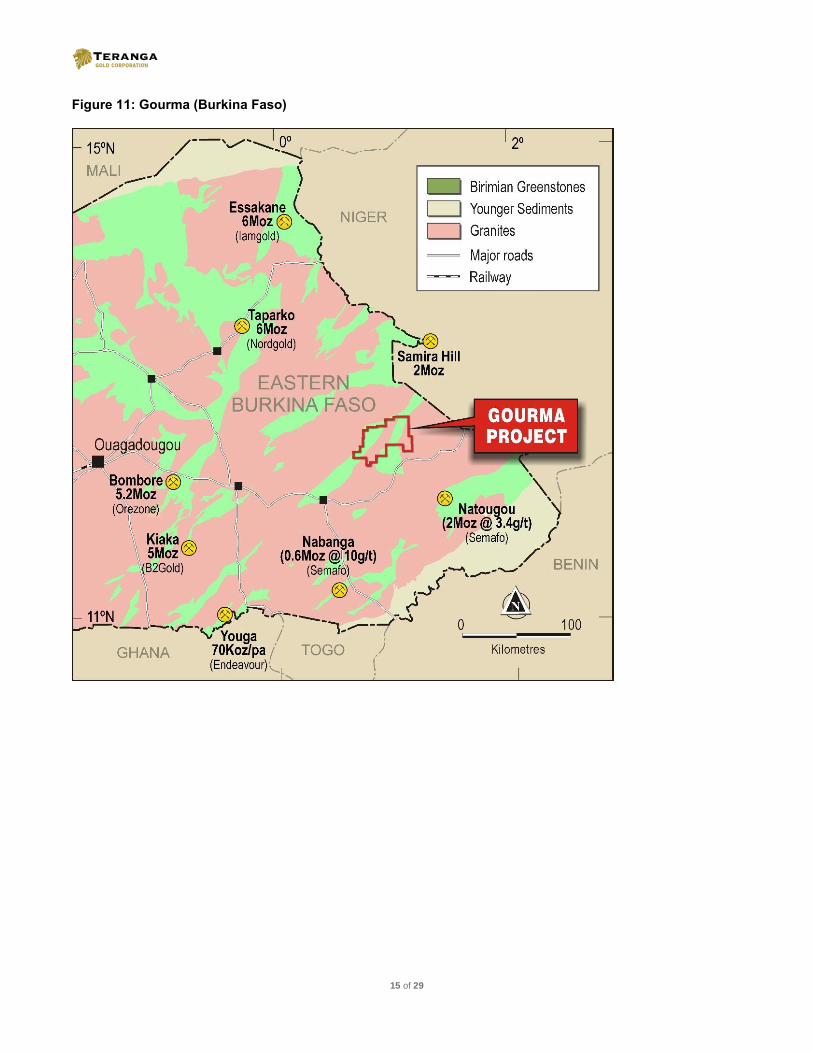
Gourma (see Figure 11 in Appendix 1) covers more than 1,300km2 of prospective greenstone belt in Eastern Burkina Faso that prior to 2010 had received no modern exploration. The project contains numerous artisanal gold workings and covers a nearly 60km strike length of a crustal scale shear zone. The work to date has utilised a combination of field and desktop work using a range of data including high quality airborne geophysics and remote sensing data. Teranga has identified six prospects within Gourma on which to continue this highly effective exploration approach during the first half of the 2017 field season.
Teranga, through its Gryphon subsidiary, holds a 51% equity interest in the joint venture agreements with Boss Resources Ltd. (“Boss”) covering both the Golden Hill and Gourma gold exploration projects. Teranga has the right to earn a further 19% interest upon delivery of a bankable feasibility study regarding a potential deposit within any of the permits comprising the joint ventures. At that point, Boss must participate on a pro-rata basis for all costs associated with the development of the project or default to 1.5% net smelter royalty interest. In addition, upon attaining a 70% equity interest, Teranga has the option to acquire a further 10% in the joint venture upon payment of AU$2.5 million dollars within 60 days of delivery of the relevant feasibility study.
NEXT STEPS
An updated feasibility study for the Banfora gold project is well underway with a revised resources and reserves estimate, which will be included in a National Instrument 43-101 Technical Report, and is targeted for completion in the second quarter of 2017.
A comprehensive 15-month exploration program has been designed for each of the Banfora, Golden Hill and Gourma gold projects and is scheduled to begin in November with the following expectations:
– to continue to convert resources within the four previously identified deposits at the Banfora gold project(2)
– to begin testing of 11 advanced stage targets within trucking distance of the proposed mill
– to initiate exploration programs on the Golden Hill property located within the highly prospective Houndé Greenstone Belt, and the Gourma property located 125km southeast of Ouagadougou.
Competent Persons Statements
The information in this news release that relates to Banfora is based on and fairly represents information which has been compiled by Mr. Sam Brooks who is a member of the Australian Institute of Geoscientists. Mr. Brooks has sufficient experience relevant to the styles of mineralisation and type of deposit under consideration and to the activity that is being undertaken to qualify as a Competent Person, as defined in the 2012 Edition of the “Australasian Code for Reporting of Exploration Results, Mineral Resources and Ore Reserves”. Mr. Brooks is a full-time employee of Teranga, and has consented to the inclusion of the matters in this news release based on
his information in the form and context in which it appears.
Teranga's disclosure of mineral reserve and mineral resource information is governed by NI 43-101 under the guidelines set out in the Canadian Institute of Mining, Metallurgy and Petroleum (the "CIM") Standards on Mineral Resources and Mineral Reserves, adopted by the CIM Council, as may be amended from time to time by the CIM ("CIM Standards"). CIM definitions of the terms "mineral reserve", "proven mineral reserve", "probable mineral reserve", "mineral resource", "measured mineral resource", "indicated mineral resource" and "inferred mineral resource", are substantially similar to the JORC Code corresponding definitions of the terms "ore reserve", "proved ore reserve", "probable ore reserve", "mineral resource", "measured mineral resource", "indicated mineral resource" and "inferred mineral resource", respectively. Estimates of mineral resources and mineral reserves prepared in

5 of 29
accordance with the JORC Code would not be materially different if prepared in accordance with the CIM definitions applicable under NI 43-101. There can be no assurance that those portions of mineral resources that are not mineral reserves will ultimately be converted into mineral reserves.
Reserve estimates for Banfora gold project
(as per January 31, 2013 Gryphon Minerals press release for 2Mtpa CIL Feasibility Study
The initial ore reserves for the Banfora gold project have been derived by Cube Consulting under the direction of Quinton de Klerk to a standard reportable in accordance with the "Australasian Code for Reporting of Exploration Results, Mineral Resources (JORC Code 2004 & NI43-101) and Ore Reserves" (JORC Code 2004) and are based on the Mineral Resource Models estimated by CSA Global in this announcement. The Ore Reserve estimate is based on the Mineral Resources classified as "Measured" and "Indicated" after consideration of all mining, metallurgical, social, environmental and financial aspects of the operation. The Proved Ore Reserve has been derived from the Measured Mineral Resource, and the Probable Ore Reserve has been derived from the Indicated Mineral Resource. The cut-off grades used in the estimation of the Banfora Ore Reserves are the non-mining, break-even gold grade taking into account mining recovery and dilution, metallurgical recovery, site operating costs, royalties and revenues. For reporting of Ore Reserves the calculated cut-off grades were rounded to the first decimal gram per tonne of gold. The cut-off grades vary depending on the material type and the pit location. The grades and metal stated in the Ore Reserves Estimate include mining recovery and dilution estimates. The Ore Reserve Estimate is reported within the open pit designs prepared as part of the January 31, 2013 Gryphon Feasibility Study.
Forward-Looking Statements
This press release contains certain statements that constitute forward-looking information within the meaning of applicable securities laws ("forward-looking statements"), which reflects management's expectations regarding Teranga Gold Corporation's ("Teranga" or the "Company") future growth, results of operations (including, without limitation, future production and capital expenditures), performance (both operational and financial) and business prospects (including the timing and development of new deposits and the success of exploration activities) and opportunities. Wherever possible, words such as "plans", "expects", "does not expect", "budget", "scheduled", "trends", "indications", "potential", "estimates", "predicts", "forecasts", "anticipate" or "does not anticipate", "believe", "intend", "ability to" and similar expressions or statements that certain actions, events or results "may", "could", "would", "might", "will", or are "likely" to be taken, occur or be achieved, have been used to identify such forward looking information. Specific forward-looking statements in this press release include commencement of expected drill programs, the anticipated exploration spend for 2017, the anticipated conversion of resources into reserves at Banfora, the timing and the completion of the updated 2Mtpa Feasibility Study for Banfora, the timing of completion of construction of Banfora including first gold pour, and anticipated future development and interest in joint venture projects. Although the forward-looking information contained in this press release reflect management's current beliefs based upon information currently available to management and based upon what management believes to be reasonable assumptions, Teranga cannot be certain that actual results will be consistent with such forward looking information. Such forward-looking statements are based upon assumptions, opinions and analysis made by management in light of its experience, current conditions and its expectations of future developments that management believe to be reasonable and relevant but that may prove to be incorrect. These assumptions include, among other things, the ability to obtain any requisite governmental approvals, the accuracy of mineral reserve and mineral resource estimates, gold price, exchange rates, fuel and energy costs, future economic conditions, anticipated future estimates of free cash flow, and courses of action. Teranga cautions you not to place undue reliance upon any such forward-looking statements.
The risks and uncertainties that may affect forward-looking statements include, among others: the inherent risks involved in exploration and development of mineral properties, including government approvals and permitting, changes in economic conditions, changes in the worldwide price of gold and other key inputs, changes in mine plans and other factors, such as project execution delays, many of which are beyond the control of Teranga, as well as other risks and uncertainties which are more fully described in Teranga's Annual Information Form dated March 30, 2016, and in other filings of Teranga with securities and regulatory authorities which are available at www.sedar.com. Teranga does not undertake any obligation to update forward-looking statements should assumptions related to these plans, estimates, projections, beliefs and opinions change. Nothing in this report
6 of 29
should be construed as either an offer to sell or a solicitation to buy or sell Teranga securities. All references to Teranga include its subsidiaries unless the context requires otherwise.
Endnotes
(1) As of the date of the acquisition of Gryphon Minerals Limited (October 13, 2016), the most recent Gryphon Reserve Estimate for the Banfora gold project was 826,000 ounces (17.4 Mt at 1.5 g/t) based on a lower capital cost heap leach processing option (see the Scheme Booklet for further details). However, as noted in Teranga’s press release dated June 19, 2016 and re-confirmed herein, Teranga’s preferred development path for the Banfora gold project is an optimized CIL flowsheet. The pro forma Combined Group Proven and Probable Mineral Reserve estimate of 3.7 million ounces as at December 31, 2015 included in Teranga’s press release dated June 19, 2016 was based on Gryphon’s CIL feasibility study Mineral Reserve estimate of 1.05 million ounces (16.7 Mt at 1.95 g/t) issued in January 2013. A number of relevant factors have changed since this estimate was issued by Gryphon Minerals in 2013, and as such and benefitting from an optimization study to be completed by Teranga, we anticipate updating the feasibility study and the resource and reserve estimates in the first half of 2017. The Mineral resources are as per Gryphon Minerals 2Mtpa Heap Leach Feasibility Study (JORC) released August 4, 2014. Complete information is available on Gryphon’s website at www.gryphonminerals.com.au and filed on the ASX at www.asx.com.au.
(2) Deposits were previously identified in a CIL Feasibility Study disclosed by Gryphon Minerals Limited on January 31, 2013.
About Teranga Gold
Teranga is a multi-jurisdictional West African gold company focused on production and development as well as the exploration of more than 5,000km2 of land located on prospective gold belts.
Since its initial public offering in 2010, Teranga has produced more than 1.2 million ounces of gold from its operations in Senegal where it is uniquely positioned with the only commercial gold mill in country. Following its recent acquisition of Gryphon, the Company is fast-tracking the development of Banfora, which is expected to commence production in 2019. Concurrent with its production and development activities, exploration programs are underway to increase its reserve base through resource conversion and making major new discoveries. Teranga has a strong balance sheet and the financial flexibility to continue to grow its business.
Steadfast in its commitment to set the benchmark for responsible mining, Teranga operates in accordance with the highest international standards and aims to act as a catalyst for sustainable economic, environmental, and community development as it strives to create value for all of its stakeholders.
For more information, please go to www.terangagold.com.
Contact Information
Richard Young Trish Moran President & CEO Head of Investor Relations T: +1 416-594-0000 | E: [email protected] T: +1 416-564-4290 | E: [email protected]

7 of 29
APPENDIX 1
Figure 1: Banfora gold project mine license plan map of recent deposits drilled (Burkina Faso)

8 of 29
Figure 2: Nogbele Plan Map (Burkina Faso)

9 of 29
Figure 3: Nogbele – Tahiti North South drill plan and 2016 drill results
Figure 4: Cross section of 2016 Tahiti North recently completed drilling results
10 of 29
Figure 5: Samavogo Plan Map (Burkina Faso)

11 of 29
Figure 6: Fourkoura Plan Map (Burkina Faso)

12 of 29
Figure 7: Banfora – Ouahiri Prospect (Burkina Faso)
Figure 8: Advanced Stage Prospects at Banfora (Burkina Faso)

13 of 29
Figure 9: Golden Hill (Burkina Faso)

14 of 29
Figure 10: Golden Hill (Burkina Faso)
Ma Trend
- Multiple mineralized zones across more than 4km
- Hydrothermal Breccia with associated gold
- High priority drill target for 2017
Nahiri Trend
- Large geochemical footprint with up to 8.6 g/t Au in soils
- Undrilled, offshoot splay structures from the regional Boni Shear
- Highest priority drill target for Q4 2016v
A Zone / Jackhammer Trend
- Multiple high-grade gold zones within a 6km trend
- Numerous artisanal workings at Jackhammer prospect
- Positive historic drill results from A, C and Peksou Prospects
- High priority drill target for Q4 2016 and 2017
15 of 29
Figure 11: Gourma (Burkina Faso)

16
Table 1: Summary of Drilling Results
Prospect Anomaly Hole ID UTM EAST
UTM NORTH
Azimuth Dip From (m)
To (m)
Interval (m)
Au (g/t)
Fourkoura Fourkoura North BNRC4817 243277 1144890 270 -60 77 78 1 1.401
Fourkoura Fourkoura North BNRC4817
85 86 1 0.829
Fourkoura Fourkoura North BNRC4818 243227 1144895 270 -60 33 35 2 4.083
Fourkoura Fourkoura North BNRC4819 243325 1144867 270 -60 66 68 2 0.627
Fourkoura Fourkoura North BNRC4819
117 123 6 3.15
Fourkoura Fourkoura North BNRC4819
128 129 1 1.103
Fourkoura Fourkoura North BNRC4820 243329 1144843 270 -60 107 108 1 0.738
Fourkoura Fourkoura North BNRC4820
122 126 4 1.807
Fourkoura Fourkoura North BNRC4820
132 133 4 0.585
Fourkoura Fourkoura North BNRC4821 243302 1144838 270 -60 99 103 4 6.562
Fourkoura Fourkoura North BNRC4822 243279 1144788 270 -60 50 53 3 0.962
Fourkoura Fourkoura North BNRC4822
83 86 3 2.075
Fourkoura Fourkoura North BNRC4823 243185 1144697 270 -60 4 6 2 0.543
Fourkoura Fourkoura North BNRC4823
270 -60 44 47 3 4.434
Fourkoura Fourkoura North BNRC4824 243202 1144673 270 -60 55 56 1 1.915
Fourkoura Fourkoura North BNRC4825 243131 1144641 270 -60 11 13 2 3.724
Fourkoura Fourkoura North BNRC4825
22 24 2 0.569
Fourkoura Fourkoura North BNRC4825
26 27 1 0.524
Fourkoura Fourkoura North BNRC4826 243175 1144489 270 -60 27 35 8 1.379
Fourkoura Fourkoura North BNRC4826
63 82 19 0.664
Fourkoura Fourkoura North BNRC4826
92 93 1 1.981
Fourkoura Fourkoura North BNRC4826
102 104 2 0.878
Fourkoura Fourkoura North BNRC4827 243076 1144490 270 -60 2 3 1 6.33
Fourkoura Fourkoura North BNRC4827
20 22 2 0.654
Fourkoura Fourkoura North BNRC4827
25 27 2 0.618
Fourkoura Fourkoura North BNRC4827
30 31 1 0.658
Fourkoura Fourkoura North BNRC4827
56 59 3 1.202
Fourkoura Fourkoura North BNRC4828 243123 1144446 270 -60 3 10 7 1.608
Fourkoura Fourkoura North BNRC4828
28 30 2 0.847
Fourkoura Fourkoura North BNRC4828
54 59 5 0.618
Fourkoura Fourkoura North BNRC4828
73 76 3 10.305
Fourkoura Fourkoura North BNRC4828
93 94 1 1.119
Fourkoura Fourkoura North BNRC4828
104 105 1 0.565
Fourkoura Fourkoura North BNRC4829 243025 1144441 270 -60 18 19 1 0.627
Fourkoura Fourkoura North BNRC4829
33 36 3 1.121
Fourkoura Fourkoura North BNRC4830 243174 1144444 270 -60 29 36 7 1.38
Fourkoura Fourkoura North BNRC4830
42 50 8 1.01
Fourkoura Fourkoura North BNRC4831 243007 1144390 270 -60 1 2 1 0.579
Fourkoura Fourkoura North BNRC4831
44 48 4 0.88
Fourkoura Fourkoura North BNRC4832 243206 1144395 270 -60 0 1 1 1.049
Fourkoura Fourkoura North BNRC4833 243157 1144395 270 -60 28 32 4 1.862
Fourkoura Fourkoura North BNRC4833
38 39 1 0.615
Fourkoura Fourkoura North BNRC4834 243010 1143546 270 -60 2 3 1 1.171
Fourkoura Fourkoura North BNRC4834
7 10 3 0.513
Fourkoura Fourkoura North BNRC4834
14 20 6 0.502
Fourkoura Fourkoura North BNRC4835 243049 1143547 270 -60 4 18 14 1.123
Fourkoura Fourkoura North BNRC4835
28 29 1 0.627
Fourkoura Fourkoura North BNRC4835
37 44 7 0.821
Fourkoura Fourkoura North BNRC4835
49 50 1 0.507
Fourkoura Fourkoura North BNRC4835
57 75 18 1.083
Fourkoura Fourkoura North BNRC4836 243115 1143540 270 -60 26 27 1 0.664
Fourkoura Fourkoura North BNRC4836
66 67 1 0.74
Fourkoura Fourkoura North BNRC4836
101 102 1 0.979
Fourkoura Fourkoura North BNRC4837 243103 1143440 270 -60 89 90 1 1.673
Fourkoura Fourkoura North BNRC4837
102 105 3 1.087
Fourkoura Fourkoura North BNRC4838 243003 1143443 270 -60 7 15 8 1.58

17 of 29
Prospect Anomaly Hole ID UTM EAST
UTM NORTH
Azimuth Dip From (m)
To (m)
Interval (m)
Au (g/t)
Fourkoura Fourkoura North BNRC4838
22 24 2 0.844
Fourkoura Fourkoura North BNRC4838
28 29 1 0.595
Fourkoura Fourkoura North BNRC4838
33 34 1 0.995
Nogbele Central BNRC4839 237600 1147569 180 -60 12 13 1 0.833
Nogbele Central BNRC4839
19 21 2 0.722
Nogbele Central BNRC4839
29 32 3 3.565
Nogbele Central BNRC4840 237629 1147565 180 -60 2 4 2 0.623
Nogbele Central BNRC4840
9 10 1 1.074
Nogbele Central BNRC4840
12 28 16 2.483
Nogbele Central BNRC4841 237624 1147588 180 -60 41 47 6 1.006
Nogbele Central BNRC4842 237653 1147581 185 -60 1 2 1 2.662
Nogbele Central BNRC4842
8 9 1 0.736
Nogbele Central BNRC4842
28 41 13 1.769
Nogbele Central BNRC4842
47 48 1 0.558
Nogbele Central BNRC4843 237553 1147571 185 -60 39 40 1 0.79
Nogbele Central- West BNRC4844 235864 1147756 185 -55 NSR
Nogbele Central- West BNRC4845 235739 1147903 185 -55 NSR
Nogbele Central- West BNRC4846 235939 1147755 185 -55 54 55 1 2.015
Nogbele Central- West BNRC4846
62 66 4 1.341
Nogbele Central- West BNRC4848 236017 1147680 185 -55 32 33 1 1.136
Nogbele Central- West BNRC4848
48 49 1 1.421
Nogbele Central- West BNRC4849 236017 1147629 185 -55 NSR
Nogbele Central- West BNRC4850 236020 1147757 185 -55 NSR
Nogbele Central- West BNRC4851 236100 1147624 180 -55 NSR
Samavogo South BNRC4852 256494 1158190 325 -60 33 37 4 0.558
Samavogo South BNRC4853 256519 1158152 325 -60 62 69 7 3.282
Samavogo South BNRC4854 256516 1158195 325 -60 39 46 7 1.387
Samavogo South BNRC4855 256623 1158351 325 -60 NSR
Samavogo Central BNRC4856 257691 1159154 325 -60 6 14 8 2.199
Samavogo Central BNRC4856
22 23 1 0.838
Samavogo Central BNRC4856
59 64 5 0.942
Samavogo Central BNRC4857 257669 1159189 325 -60 15 16 1 0.8
Samavogo Central BNRC4857
50 52 2 0.619
Samavogo Central BNRC4858 257643 1159226 325 -60 NSR
Samavogo Central BNRC4859 257695 1159231 325 -60 8 9 1 0.879
Samavogo Central BNRC4859
15 21 6 0.528
Samavogo Central BNRC4860 257719 1159193 325 -60 7 8 1 1.558
Samavogo Central BNRC4860
13 15 2 1.167
Samavogo Central BNRC4860
31 36 5 2.044
Samavogo Central BNRC4860
53 59 6 1.012
Samavogo Central BNRC4861 257727 1159257 325 -60 5 9 4 1.051
Samavogo Central BNRC4861
42 44 2 1.068
Samavogo Central BNRC4862 257752 1159294 325 -60 34 39 5 3.925
Samavogo Central BNRC4863 257778 1159263 325 -60 46 50 4 0.6
Samavogo North BNRC4864 258119 1159601 325 -60 64 67 3 1.104
Samavogo North BNRC4865 258123 1159668 325 -60 36 38 2 1.145
Samavogo South BNRC4866 257234 1158674 325 -60 32 33 1 0.547
Samavogo South BNRC4866
45 46 1 0.53
Samavogo South BNRC4867 257159 1158639 325 -60 32 34 2 4.84
Samavogo South BNRC4868 257255 1158699 325 -60 29 32 3 0.502
Samavogo South BNRC4869 256932 1158471 325 -60 49 56 7 0.731
Samavogo South BNRC4870 256906 1158505 325 -60 12 29 17 1.421
Samavogo South BNRC4871 256772 1158442 325 -60 5 6 1 0.521
Samavogo South BNRC4872 256809 1158420 325 -60 42 44 2 2.027
Samavogo South BNRC4873 256667 1158223 325 -60 82 88 6 3.151
Samavogo South BNRC4873
94 97 3 0.714
Samavogo North BNRC4874 258441 1159875 325 -60 9 16 7 0.853
Samavogo North BNRC4874
42 48 6 1.693

18 of 29
Prospect Anomaly Hole ID UTM EAST
UTM NORTH
Azimuth Dip From (m)
To (m)
Interval (m)
Au (g/t)
Samavogo North BNRC4875 258429 1159894 325 -60 6 7 1 0.509
Samavogo North BNRC4875
27 28 1 1.709
Samavogo North BNRC4875
35 39 4 2.003
Samavogo North BNRC4876 258561 1159935 325 -60 25 26 1 0.737
Samavogo North BNRC4876
40 42 2 0.631
Samavogo North BNRC4876
61 62 1 0.619
Samavogo North BNRC4877 258605 1160012 325 -60 20 22 2 0.834
Samavogo North BNRC4877
56 59 3 1.825
Samavogo North BNRC4878 258694 1159973 325 -60 56 60 4 0.654
Samavogo North BNRC4879 258729 1159982 325 -60 11 14 3 0.706
Samavogo North BNRC4880 258708 1160015 325 -60 NSR
Samavogo North BNRC4881 258676 1160068 325 -60 NSR
Samavogo North BNRC4882 258652 1160103 325 -60 15 17 2 0.962
Samavogo North BNRC4883 258652 1160020 325 -60 22 23 1 0.928
Samavogo North BNRC4883
43 44 1 0.648
Samavogo North BNRC4883
55 59 4 0.628
Samavogo North BNRC4884 258975 1160238 325 -60 29 32 3 0.687
Samavogo North BNRC4885 258989 1160219 325 -60 39 41 2 1.675
Samavogo North BNRC4886 258805 1160165 325 -60 1 2 1 0.944
Samavogo North BNRC4886
17 18 1 0.592
Samavogo North BNRC4887 258790 1160190 325 -60 11 13 2 0.553
Samavogo North BNRC4888 259023 1160223 325 -60 42 44 2 0.86
Samavogo North BNRC4889 258999 1160259 325 -60 21 25 4 0.821
Samavogo North BNRC4890 259070 1160272 325 -60 32 36 4 0.871
Samavogo North BNRC4891 259047 1160310 325 -60 16 18 2 0.65
Samavogo North BNRC4892 259112 1160285 325 -60 35 41 6 0.901
Samavogo North BNRC4893 259086 1160320 325 -60 14 22 8 1.094
Samavogo North BNRC4894 259130 1160324 325 -60 22 23 1 0.514
Samavogo North BNRC4894
27 33 6 0.646
Samavogo North BNRC4895 259102 1160363 325 -60 NSR
Samavogo North BNRC4896 259169 1160335 325 -60 23 27 4 0.836
Samavogo North BNRC4896
31 32 1 0.642
Samavogo North BNRC4897 259145 1160373 325 -60 9 10 1 0.897
Samavogo North BNRC4898 259203 1160358 325 -60 28 29 1 0.597
Samavogo North BNRC4899 259182 1160391 325 -60 11 19 8 1.16
Samavogo North BNRC4900 259241 1160375 325 -60 23 31 8 1.081
Samavogo North BNRC4901 259018 1160413 325 -60 7 10 3 1.165
Samavogo North BNRC4902 259287 1160379 325 -60 34 36 2 0.671
Samavogo North BNRC4903 259268 1160412 325 -60 18 19 1 0.966
Samavogo North BNRC4904 259348 1160365 325 -60 42 43 1 0.538
Samavogo North BNRC4905 259326 1160395 325 -60 33 34 1 2.249
Samavogo North BNRC4906 259288 1160448 325 -60 9 11 2 0.988
Samavogo North BNRC4906
17 18 1 0.731
Samavogo North BNRC4907 259313 1160477 325 -60 12 13 1 0.818
Samavogo North BNRC4908 259304 1160494 325 -60 8 9 1 0.579
Samavogo North BNRC4909 259392 1160442 325 -60 NSR
Samavogo North BNRC4910 259372 1160476 325 -60 NSR
Samavogo North BNRC4911 259346 1160510 325 -60 5 6 1 0.862
Samavogo North BNRC4911
9 13 4 0.57
Nogbele North BNRC4916 237130 1147881 180 -60 23 24 1 1.183
Nogbele North BNRC4916
45 53 8 0.669
Nogbele North BNRC4917 237148 1147875 180 -60 0 21 21 0.962
Nogbele North BNRC4918 237180 1147866 180 -60 23 24 1 0.572
Nogbele North BNRC4918
33 34 1 0.609
Nogbele North BNRC4919 237176 1147889 180 -60 0 2 2 1.362
Nogbele North BNRC4919
14 16 2 0.944
Nogbele North BNRC4919
24 26 2 1.275
Nogbele North BNRC4920 237224 1147926 180 -60 NSR

19 of 29
Prospect Anomaly Hole ID UTM EAST
UTM NORTH
Azimuth Dip From (m)
To (m)
Interval (m)
Au (g/t)
Nogbele North BNRC4921 237225 1147898 180 -60 0 2 2 0.554
Nogbele North BNRC4921
13 14 1 0.639
Nogbele North BNRC4921
24 28 4 0.706
Nogbele North BNRC4921
54 55 1 0.609
Nogbele North BNRC4921
59 60 1 1.151
Nogbele North BNRC4922 237279 1147889 180 -60 34 36 2 0.881
Nogbele North BNRC4923 237203 1147942 180 -60 3 7 4 0.861
Nogbele North BNRC4923
16 32 16 0.672
Nogbele North BNRC4923
38 39 1 0.621
Nogbele North BNRC4924 237150 1147940 180 -90 5 14 9 0.851
Nogbele North BNRC4924
22 38 16 0.945
Nogbele North BNRC4924
50 51 1 0.547
Nogbele North BNRC4925 237104 1147940 180 -60 15 17 2 1.729
Nogbele North BNRC4925
32 41 9 2.975
Nogbele North BNRC4926 237052 1147912 180 -60 13 19 6 3.565
Nogbele Central- West BNRC4927 236380 1147215 180 -60 29 33 4 2.211
Nogbele Central- West BNRC4927
42 44 2 1.244
Nogbele Central- West BNRC4928 236327 1147240 180 -60 16 22 6 3.166
Nogbele Central- West BNRC4928
34 35 1 1.208
Nogbele Central- West BNRC4928
42 44 2 0.909
Nogbele Central- West BNRC4929 236264 1147196 180 -60 7 8 1 0.638
Nogbele Central- West BNRC4929
15 16 1 2.59
Nogbele Central- West BNRC4929
33 34 1 0.513
Nogbele Central- West BNRC4929
45 46 1 0.604
Nogbele Central- West BNRC4930 236264 1147235 180 -60 42 43 1 0.665
Nogbele Central- West BNRC4930
52 53 1 0.833
Nogbele Central- West BNRC4931 236126 1147221 180 -60 51 52 1 0.528
Nogbele Central- West BNRC4932 236351 1147316 180 -60 23 26 3 3.123
Nogbele Central- West BNRC4932
47 56 9 1.065
Nogbele Central- West BNRC4932
64 65 1 0.603
Nogbele Central- West BNRC4932
67 68 1 0.595
Nogbele Central- West BNRC4933 236328 1147281 180 -60 27 32 5 0.972
Nogbele Central- West BNRC4933
71 72 1 0.687
Nogbele Central- West BNRC4933
78 84 6 1.4
Nogbele Central- West BNRC4934 236426 1147323 180 -60 58 62 4 2.675
Nogbele Central- West BNRC4934
67 68 1 0.549
Fourkoura Fourkoura BNDD3573 243208 1144244 265 -60 107 108 1 0.52
Fourkoura Fourkoura BNDD3573
115 116 1 0.667
Fourkoura Fourkoura BNDD3573
139 140 1 1.049
Fourkoura Fourkoura BNDD3574 243311 1144789 265 -60 97.8 100.4 2.6 5.599
Fourkoura Fourkoura BNDD3575 243301 1144815 270 -60 81 82 1 0.608
Fourkoura Fourkoura BNDD3575
92.5 99 6.5 1.225
Fourkoura Fourkoura BNDD3576 243183 1144637 265 -60 22 23 1 10.251
Fourkoura Fourkoura BNDD3576
62 63 1 1.836
Fourkoura Fourkoura BNDD3577 243102 1144587 265 -60 10 11 1 0.643
Fourkoura Fourkoura BNDD3577
38.2 42.1 3.9 4
Fourkoura Fourkoura BNDD3578 243147 1144589 265 -60 3 5 2 0.789
Fourkoura Fourkoura BNDD3578
50 51 1 0.943
Fourkoura Fourkoura BNDD3578
69 70 1 1.529
Fourkoura Fourkoura BNDD3579 243154 1144515 270 -60 53 56 3 0.573
Fourkoura Fourkoura BNDD3579
104.1 106 1.9 0.833
Fourkoura Fourkoura BNDD3580 243075 1144444 270 -60 9 17 8 1.027
Fourkoura Fourkoura BNDD3580
28 32 4 0.601
Fourkoura Fourkoura BNDD3581 243059 1144389 270 -60 2 3 1 0.508
Fourkoura Fourkoura BNDD3581
9 10 1 0.64
Fourkoura Fourkoura BNDD3581
12 14 2 0.657
Fourkoura Fourkoura BNDD3581
27 28 1 1.5
Fourkoura Fourkoura BNDD3581
40 48 8 0.573

20 of 29
Prospect Anomaly Hole ID UTM EAST
UTM NORTH
Azimuth Dip From (m)
To (m)
Interval (m)
Au (g/t)
Fourkoura Fourkoura BNDD3581
50 51 1 0.698
Fourkoura Fourkoura BNDD3581
58 59 1 1.498
Fourkoura Fourkoura BNDD3581
69 79 10 0.85
Fourkoura Fourkoura BNDD3582 243104 1144487 270 -60 0 4 4 0.629
Fourkoura Fourkoura BNDD3582
11 12 1 0.676
Fourkoura Fourkoura BNDD3582
24 27 3 0.6
Fourkoura Fourkoura BNDD3582
30 31 1 0.513
Fourkoura Fourkoura BNDD3582
52 59 7 0.636
Fourkoura Fourkoura BNDD3582
66 68 2 1.53
Fourkoura Fourkoura BNDD3583 243325 1144720 270 -60 124 131 7 0.774
Fourkoura Fourkoura BNDD3584 243307 1144741 270 -60 112 114 2 1.538
Fourkoura Fourkoura BNDD3585 243235 1144693 270 -60 57 65 8 0.513
Fourkoura Fourkoura BNDD3590 243100 1143635 270 -60 28 40.4 12.4 2.897
Fourkoura Fourkoura BNDD3590
56 57 1 0.91
Fourkoura Fourkoura BNDD3590
66.5 67.73 1.23 0.551
Fourkoura Fourkoura BNDD3591 243146 1143634 270 -60 65 66 1 5.124
Fourkoura Fourkoura BNDD3591
106 107 1 0.508
Fourkoura Fourkoura BNDD3592 243144 1143593 270 -60 84 92.5 8.5 0.944
Fourkoura Fourkoura BNDD3593 243074 1143593 270 -60 39.13 50 10.87 1.47
Fourkoura Fourkoura BNDD3593
55 60 5 0.655
Fourkoura Fourkoura BNDD3593
84 90 6 2.521
Fourkoura Fourkoura BNDD3594 243040 1143593 270 -60 9 10 1 1.02
Fourkoura Fourkoura BNDD3594
67 68 1 1.006
Fourkoura Fourkoura BNDD3595 243002 1143491 270 -60 23 29 6 2.723
Fourkoura Fourkoura BNDD3596 243069 1143495 270 -60 5 13 8 0.721
Fourkoura Fourkoura BNDD3596
23 25 2 0.773
Fourkoura Fourkoura BNDD3596
28 40 12 0.698
Fourkoura Fourkoura BNDD3596
47 48 1 0.578
Fourkoura Fourkoura BNDD3597 243057 1143441 270 -60 23 24 1 2.12
Fourkoura Fourkoura BNDD3597
30 31 1 0.781
Fourkoura Fourkoura BNDD3597
32 33 1 0.648
Fourkoura Fourkoura BNDD3597
60 61 1 1.502
Nogbele West BNDD3598 236377 1147255 180 -60 61.6 67 5.4 0.704
Nogbele North BNDD3599 236375 1147315 175 -60 60 61 1 2.06
Nogbele North BNDD3599
66 73 7 2.58
Nogbele North BNDD3599
101 102 1 0.598
Nogbele Tahiti North BNDD3600 236322 1146391 235 -55 68 69 1 0.586
Nogbele Tahiti North BNDD3600
82 84 2 1.117
Nogbele Tahiti North BNDD3600
98 154 56 0.795
Nogbele North BNDD3801 237176 1148022 180 -60 57 58 1 1.227
Nogbele North BNDD3801
60 68 8 1.954
Nogbele North BNDD3802 237126 1148017 175 -55 31 32 1 0.5
Nogbele North BNDD3802
34 35 1 0.51
Nogbele North BNDD3802
36 37 1 0.626
Nogbele North BNDD3802
38 42 4 0.689
Nogbele North BNDD3802
46 51 5 0.505
Nogbele North BNDD3802
71.6 74 2.4 14.559
Nogbele North BNDD3803 237101 1148054 175 -60 70 71 1 0.617
Nogbele North BNDD3803
101 104 3 3.376
Nogbele North BNDD3803
118 119 1 0.574
Nogbele North BNDD3804 237053 1148019 180 -55 79 82.5 3.5 3.158
Nogbele North BNDD3805 237128 1148003 175 -45 60 70.4 10.4 0.825
Nogbele North BNDD3807 237079 1148016 180 -45 45 47 2 3.373
Nogbele North BNDD3807
71 74 3 6.441
Nogbele North BNDD3807
84 85 1 0.581
Nogbele North BNDD3808 237728 1148325 180 -45 21 22 1 0.769
Nogbele North BNDD3808
26 28 2 0.669
Nogbele North BNDD3808
58 59 1 0.815

21 of 29
Prospect Anomaly Hole ID UTM EAST
UTM NORTH
Azimuth Dip From (m)
To (m)
Interval (m)
Au (g/t)
Nogbele North BNDD3808
62 63 1 1.016
Nogbele North BNDD3808
99 103 4 15.071
Nogbele North BNDD3809 237780 1148313 180 -45 58 59 1 2.347
Nogbele North BNDD3809
67.65 69.4 1.75 2.56
Nogbele North BNDD3811 237080 1147962 175 -70 43 55 12 1.312
Nogbele North BNDD3812 237051 1148041 175 -60 99.5 104 4.5 1.672
Nogbele North BNDD3814 236992 1148256 145 -60 76 78 2 1.164
Nogbele North BNDD3815 237006 1148235 72 74 2 7.305
Nogbele North BNDD3816 237752 1148327 180 -45 63 65 2 1.9
Nogbele North BNDD3816 78 79.2 1.2 0.75
Nogbele North BNDD3816 90 99 9 0.015
Nogbele Tahiti North BNDD3821 236377 1146318 235 -55 52 67 15 0.703
Nogbele Tahiti North BNDD3821
76 77 1 0.915
Nogbele Tahiti North BNDD3821
92 93 1 1.094
Nogbele Tahiti North BNDD3822 236347 1146295 235 -55 53 55 2 2.988
Nogbele Tahiti North BNDD3823 236359 1146360 235 -55 43 53 10 0.633
Nogbele Tahiti North BNDD3823
64 65 1 0.575
Nogbele Tahiti North BNDD3823
80 81 1 1.109
Nogbele Tahiti North BNDD3823
90 100 10 2.362
Nogbele Tahiti North BNDD3823
105 108 3 2.044
Nogbele Tahiti North BNDD3823
135 142 7 0.579
Nogbele Tahiti North BNDD3824 236320 1146337 230 -55 20 21 1 0.511
Nogbele Tahiti North BNDD3824
22 31 9 1.164
Nogbele Tahiti North BNDD3824
41 42 1 0.875
Nogbele Tahiti North BNDD3824
53.7 70.5 16.8 1.491
Nogbele Tahiti North BNDD3824
83.6 90.6 7 0.708
Nogbele Tahiti North BNDD3825 236283 1146305 235 -55 25 26 1 1.029
Nogbele Tahiti North BNDD3826 236286 1146367 235 -55 21 50 29 2.685
Nogbele Tahiti North BNDD3826
59 60 1 2.853
Nogbele Tahiti North BNDD3826
76 79 3 1.414
Nogbele Tahiti North BNDD3827 236263 1146415 235 -55 66 82 16 1.824
Nogbele Tahiti North BNDD3827
90 91 1 5.362
Nogbele Tahiti North BNDD3827
100 101 1 1.264
Nogbele Tahiti North BNDD3827
104 105 1 0.573
Nogbele North BNDD3829 237006 1148234 325 -85 72 75 3 2.791
Nogbele North BNDD3829 88 89 1 0.799
Samavogo Central BNDD3831 257337 1158580 325 -60 106 112 6 5.458
Samavogo Central BNDD3832 257490 1158700 325 -60 42 43 1 1.078
Samavogo Central BNDD3832 94 99 5 0.937
Samavogo Central BNDD3833 257516 1158821 325 -90 43 62 19 4.111
Samavogo Central BNDD3833 87 91 4 0.683
Notes: 1. True widths are unknown. 2. Intercept gold values are determined from uncapped assays. 3. UTM Coordinates are WGS84 30N
22 of 29
APPENDIX 2
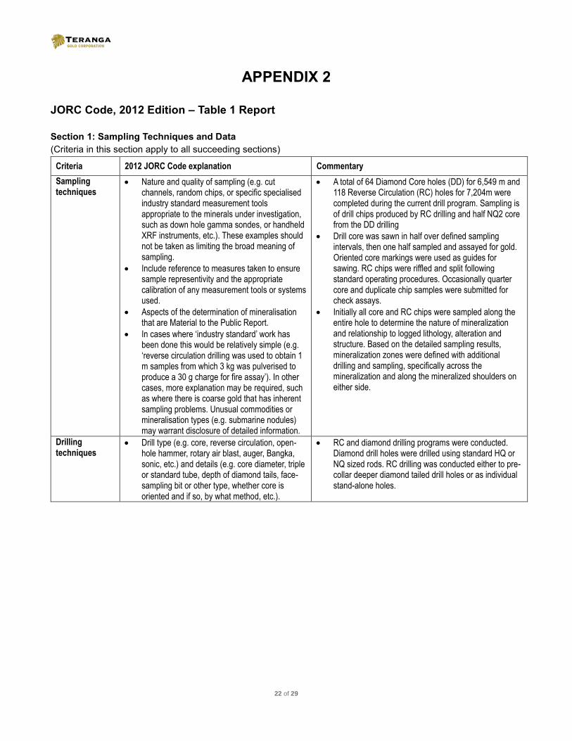
JORC Code, 2012 Edition – Table 1 Report
Section 1: Sampling Techniques and Data
(Criteria in this section apply to all succeeding sections)
Criteria 2012 JORC Code explanation Commentary
Sampling techniques
Nature and quality of sampling (e.g. cut channels, random chips, or specific specialised industry standard measurement tools appropriate to the minerals under investigation, such as down hole gamma sondes, or handheld XRF instruments, etc.). These examples should not be taken as limiting the broad meaning of sampling.
Include reference to measures taken to ensure sample representivity and the appropriate calibration of any measurement tools or systems used.
Aspects of the determination of mineralisation that are Material to the Public Report.
In cases where ‘industry standard’ work has been done this would be relatively simple (e.g. ‘reverse circulation drilling was used to obtain 1 m samples from which 3 kg was pulverised to produce a 30 g charge for fire assay’). In other cases, more explanation may be required, such as where there is coarse gold that has inherent sampling problems. Unusual commodities or mineralisation types (e.g. submarine nodules) may warrant disclosure of detailed information.
A total of 64 Diamond Core holes (DD) for 6,549 m and 118 Reverse Circulation (RC) holes for 7,204m were completed during the current drill program. Sampling is of drill chips produced by RC drilling and half NQ2 core from the DD drilling
Drill core was sawn in half over defined sampling intervals, then one half sampled and assayed for gold. Oriented core markings were used as guides for sawing. RC chips were riffled and split following standard operating procedures. Occasionally quarter core and duplicate chip samples were submitted for check assays.
Initially all core and RC chips were sampled along the entire hole to determine the nature of mineralization and relationship to logged lithology, alteration and structure. Based on the detailed sampling results, mineralization zones were defined with additional drilling and sampling, specifically across the mineralization and along the mineralized shoulders on either side.
Drilling techniques
Drill type (e.g. core, reverse circulation, open-hole hammer, rotary air blast, auger, Bangka, sonic, etc.) and details (e.g. core diameter, triple or standard tube, depth of diamond tails, face-sampling bit or other type, whether core is oriented and if so, by what method, etc.).
RC and diamond drilling programs were conducted. Diamond drill holes were drilled using standard HQ or NQ sized rods. RC drilling was conducted either to pre-collar deeper diamond tailed drill holes or as individual stand-alone holes.
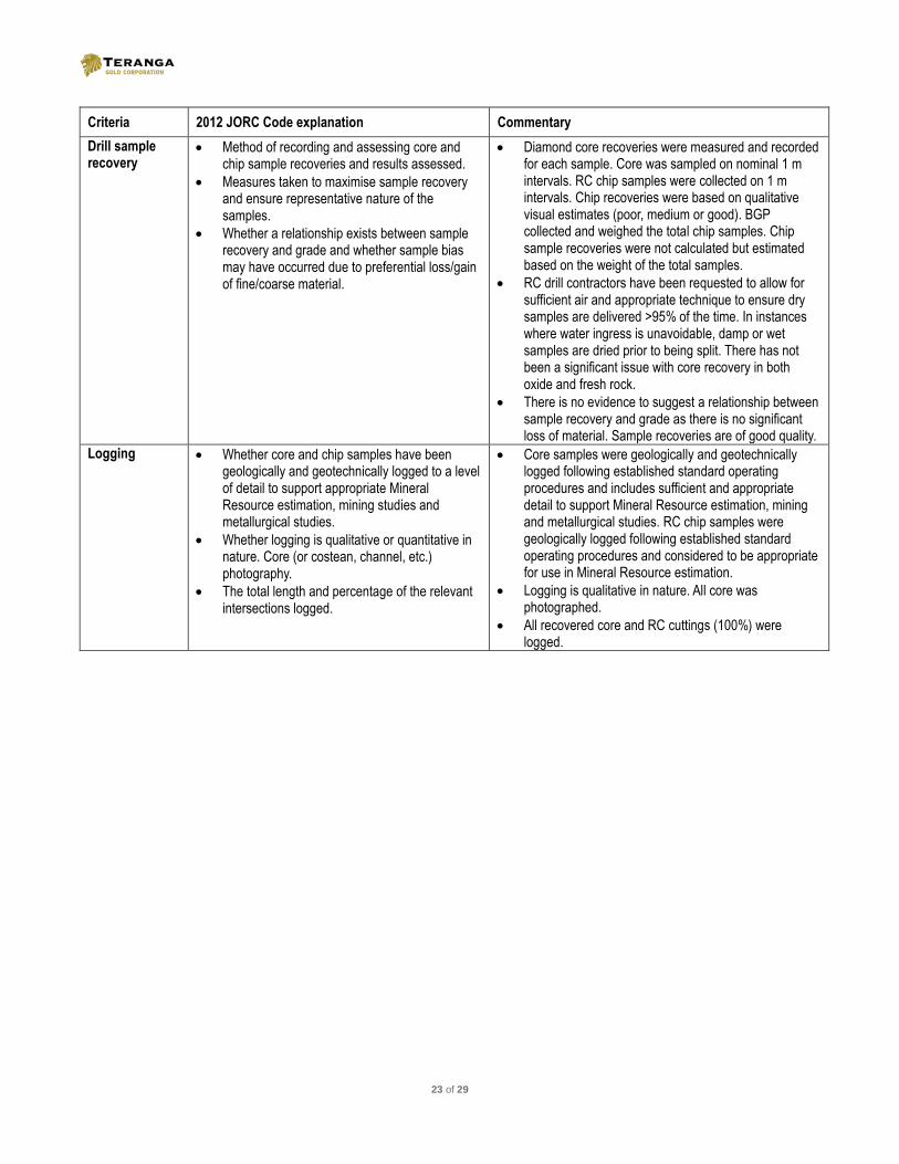
23 of 29
Criteria 2012 JORC Code explanation Commentary
Drill sample recovery
Method of recording and assessing core and chip sample recoveries and results assessed.
Measures taken to maximise sample recovery and ensure representative nature of the samples.
Whether a relationship exists between sample recovery and grade and whether sample bias may have occurred due to preferential loss/gain of fine/coarse material.
Diamond core recoveries were measured and recorded for each sample. Core was sampled on nominal 1 m intervals. RC chip samples were collected on 1 m intervals. Chip recoveries were based on qualitative visual estimates (poor, medium or good). BGP collected and weighed the total chip samples. Chip sample recoveries were not calculated but estimated based on the weight of the total samples.
RC drill contractors have been requested to allow for sufficient air and appropriate technique to ensure dry samples are delivered >95% of the time. In instances where water ingress is unavoidable, damp or wet samples are dried prior to being split. There has not been a significant issue with core recovery in both oxide and fresh rock.
There is no evidence to suggest a relationship between sample recovery and grade as there is no significant loss of material. Sample recoveries are of good quality.
Logging Whether core and chip samples have been geologically and geotechnically logged to a level of detail to support appropriate Mineral Resource estimation, mining studies and metallurgical studies.
Whether logging is qualitative or quantitative in nature. Core (or costean, channel, etc.) photography.
The total length and percentage of the relevant intersections logged.
Core samples were geologically and geotechnically logged following established standard operating procedures and includes sufficient and appropriate detail to support Mineral Resource estimation, mining and metallurgical studies. RC chip samples were geologically logged following established standard operating procedures and considered to be appropriate for use in Mineral Resource estimation.
Logging is qualitative in nature. All core was photographed.
All recovered core and RC cuttings (100%) were logged.

24 of 29
Criteria 2012 JORC Code explanation Commentary
Sub-sampling techniques and sample preparation
If core, whether cut or sawn and whether quarter, half or all core taken.
If non-core, whether riffled, tube sampled, rotary split, etc. and whether sampled wet or dry.
For all sample types, the nature, quality and appropriateness of the sample preparation technique.
Quality control procedures adopted for all sub-sampling stages to maximise representivity of samples.
Measures taken to ensure that the sampling is representative of the in situ material collected, including for instance results for field duplicate/second-half sampling.
Whether sample sizes are appropriate to the grain size of the material being sampled.
Drill core sampling intervals were defined then cut in half with a diamond saw along the core length following orientation lines. Half core was sampled over approximate one meter lengths or based on lithology intervals.
RC sampled by riffle splitting dry samples using a tiered splitter to 3kg sample and submitted for analysis
RC samples are split to 3 kg sample in the field by tiered splitter for dispatch to assay lab. At time of field splitting a second duplicate sample is collected for every interval and stored on site. The primary sample is pulverized in entirety at BIGGs in Laboratory in Ouagadougou by LM2 and split to a 200 g sub sample using riffle splitting. A 50 g subsample from this pulp is then selected for analysis. Sampling and subsampling methods are industry standard and are appropriate for the type of drilling. The use of the riffle tiered splitter is a demonstrated method of accurately splitting the primary sample and the field method has been validated with the field duplicate data over the life of the BGP.
For RC chips field duplicate sample collected every 20 samples and submitted to the laboratory to assess precision of the riffle splitting. Field duplicate data is routinely reviewed and show acceptable precision and variability.
Field duplicate data indicates acceptable variability indicating coarse gold is not a significant issue in the sampling.
Quality of assay data and laboratory tests
The nature, quality and appropriateness of the assaying and laboratory procedures used and whether the technique is considered partial or total.
For geophysical tools, spectrometers, handheld XRF instruments, etc., the parameters used in determining the analysis including instrument make and model, reading times, calibrations factors applied and their derivation, etc...
Nature of quality control procedures adopted (e.g. standards, blanks, duplicates, external laboratory checks) and whether acceptable levels of accuracy (ie lack of bias) and precision have been established.
Gold assays for RC drilling were obtained by using a 50g charge for a lead collection fire assay with an AAS finish. This is considered to be total gold estimate. Assaying was conducted in Ouagadougou by BIGGS Laboratories.
Not applicable
Certified reference materials, blanks and duplicates are regularly inserted into the sample preparation and analysis process with approximately 10% of all samples being related to quality control.
Data is reviewed before being accepted into the database. Any batches failing QAQC analysis resubmitted for check assays. Dataset QAQC contains acceptable levels of precision and accuracy.

25 of 29
Criteria 2012 JORC Code explanation Commentary
Verification of sampling and assaying
The verification of significant intersections by either independent or alternative company personnel.
The use of twinned holes.
Documentation of primary data, data entry procedures, data verification, data storage (physical and electronic) protocols.
Discuss any adjustment to assay data.
Significant intersections have been reviewed by staff geologists to check the geological context.
No twin holes have been undertaken in this programme.
All sample and recovery data is recorded to paper forms at the time of drilling. Data is then keypunched into controlled excel templates with validation. Geological logging is directly logged into template log sheets by Toughbook computer. The templates are then provided to an internal database manager for loading in Datashed database management software. Referential integrity is checked as part of the data loading process into Datashed.
Location of data points
Accuracy and quality of surveys used to locate drill holes (collar and down-hole surveys), trenches, mine workings and other locations used in Mineral Resource estimation.
Specification of the grid system used.
Quality and adequacy of topographic control.
Drillhole collar locations were surveyed by trained site based technicians using real time differential GPS (DGPS) to a sub decimetre accuracy in horizontal and vertical position. Signal correction completed using the Omnistar network. Vertical precision was supplemented using a Digital Surface Model created from WorldView-2 stereo imagery incorporating DGPS ground control points. Down hole drill hole surveys were undertaken by the drill contractor utilizing a Reflex EZ-Shot downhole survey instrument and by single shot Eastman Cameras. Survey intervals of 30m and end of hole were routinely collected. No strongly magnetic rock is present units are present within the deposit which may upset magnetic based readings.
Topographic control is based on World View 2 stereoscopic processed image, providing additional <1m RL precision.
Data spacing and distribution
Data spacing for reporting of Exploration Results.
Whether the data spacing and distribution is sufficient to establish the degree of geological and grade continuity appropriate for the Mineral Resource and Ore Reserve estimation procedure(s) and classifications applied.
Whether sample compositing has been applied.
Drilling is nominally on a 40 m by 20 m spacing, at Samavogo Deposit and 25m x 25m spacing at the Nogbele and Fourkoura Deposits.
Geological interpretation based on drill spacing has identified continuity of geology and grade and is determined to be sufficient for estimating Mineral Resources and Mineral Reserves. Experimental variograms generated for mineralized zones with sufficient data, have confirmed the grade continuity ranges based on the drill hole spacing.
RC chips and diamond drill core were sampled on nominal 1 meter intervals down the hole, and assayed. Sample compositing was not applied.

26 of 29
Criteria 2012 JORC Code explanation Commentary
Orientation of data in relation to geological structure
Whether the orientation of sampling achieves unbiased sampling of possible structures and the extent to which this is known, considering the deposit type.
If the relationship between the drilling orientation and the orientation of key mineralised structures is considered to have introduced a sampling bias, this should be assessed and reported if material.
Drill hole azimuths and dips have been oriented perpendicular to the interpreted mineralized zones in order to intersect the true widths of the zones as closely as possible. Occasionally, drilling was planned at oblique angles when the mineralization trends were not yet well defined or if the optimal collar location was not accessible. Generally, the majority of drilling is oriented such that the sampling of mineralization is unbiased.
The small percentage of holes oriented oblique to the mineralization are located in areas with sufficient drill density oriented perpendicular to mineralization, and will not introduce a significant sampling bias.
Sample security
The measures taken to ensure sample security. Samples are removed from the field immediately upon drilling and stored in a secure compound for sub sampling and preparation for lab dispatch. Samples are collected directly from site by the laboratory. Sample submission forms are sent in paper form with the samples as well as electronically to the laboratory. Reconciliation of samples occurs prior to commencement of sample preparation of dispatches
Audits or reviews
The results of any audits or reviews of sampling techniques and data.
All QA/QC data is reviewed in an ongoing basis and reported in monthly summaries. All QAQC data up until December 2012 has been reviewed and documented by CSA Global of Perth. Data subsequent to this period has been reviewed by the CP for this release.

27 of 29
Section 2: Reporting of Exploration Results
(Criteria listed in the preceding section also apply to this section.)
Criteria 2012 JORC Code explanation Commentary
Mineral tenement and land tenure status
Type, reference name/number, location and ownership including agreements or material issues with third parties such as joint ventures, partnerships, overriding royalties, native title interests, historical sites, wilderness or national park and environmental settings.
The security of the tenure held at the time of reporting along with any known impediments to obtaining a licence to operate in the area.
Drilling reported here has been completed on the Waghnion Exploitation permit (2014-675 PRES/PM/MME/MEF/MEDD) The Banfora Gold Project, comprises a further 6 exploration tenements, namely Nogbele (Arrete No. 2013 0000 95/MME/SG/DGMG), Nianka (Arrete No. 2013 000133/MME/SG/DGMG), Dierisso (Arrete No. 2015-000-210 /MME/SG/DGMGC), Nianka Nord (Arrete No. 2015-000-211 ME/SG/DGMG), Zeguedougou (Arrete No. 2015-000-9/MME/SG/DGMG), Nogbele Sud (Arrete No. 16-042 /MEMC/SG/DGMG).
Gryphon Minerals Ltd is 100% holder of the Exploitation and Exploration Permits.
No historical sites, wilderness or national park are located in the permit area.
Tenure is considered secure, Gryphon Minerals has been granted a mining license for the Banfora Gold Project.
Exploration done by other parties
Acknowledgment and appraisal of exploration by other parties.
Prior to Teranga’s acquisition of the Gryphon Minerals Ltd in October 2016, exploration work on the BGP was conducted by Gryphon Minerals Ltd.
Geology Deposit type, geological setting and style of mineralisation.
The Banfora Gold Project covers greenstone belts and intra belt granitoids of the Proterozoic Birimian Shield. The oldest rocks within the concession are interpreted to be tholeitic to calc-alkaline basalts, andesites and volcaniclastic sediments. Predominately mafic, volcano-sedimentary packages dominate the younger parts of the local stratigraphy. Numerous phases of plutonic activity have intruded the earlier sequences ranging from gabbroic to granitic in composition. Known mineralisation is structurally controlled and widely associated with hematite, iron carbonate, sericite, pyrite and locally albitic alteration. Both the mafic volcano-sedimentary packages and the coarse grained intrusive rocks host significant mineralisation in the project area.

28 of 29
Criteria 2012 JORC Code explanation Commentary
Drill hole Information
A summary of all information material to the understanding of the exploration results including a tabulation of the following information for all Material drill holes: o easting and northing of the drill hole collar o elevation or RL (Reduced Level – elevation
above sea level in metres) of the drill hole collar
o dip and azimuth of the hole o down hole length and interception depth o hole length.
If the exclusion of this information is justified on the basis that the information is not Material and this exclusion does not detract from the understanding of the report, the Competent Person should clearly explain why this is the case.
All drill hole collar locations, azimuth, dip and gold assay intercept data received to date is available on the Teranga Gold company website at www.terangagold.com.
Data aggregation methods
In reporting Exploration Results, weighting averaging techniques, maximum and/or minimum grade truncations (e.g. cutting of high-grades) and cut-off grades are usually Material and should be stated.
Where aggregate intercepts incorporate short lengths of high grade results and longer lengths of low grade results, the procedure used for such aggregation should be stated and some typical examples of such aggregations should be shown in detail.
The assumptions used for any reporting of metal equivalent values should be clearly stated.
Gold intercepts are reported as length-weighted average grades in grams per tonne, with a maximum of 4 metres contiguous internal dilution and no external dilution. Assays are not capped prior to averaging. A 0.5 g/t Au minimum cut-off grade was applied.
Grade intersections and inclusive higher grade intersections are reported separately and available on the Teranga Gold company website at www.terangagold.com.
Relationship between mineralisation widths and intercept lengths
These relationships are particularly important in the reporting of Exploration Results.
If the geometry of the mineralisation with respect to the drill hole angle is known, its nature should be reported.
If it is not known and only the down hole lengths are reported, there should be a clear statement to this effect (e.g. ‘down hole length, true width not known’).
Down hole core lengths are reported, as true widths have not yet been determined.
Diagrams Appropriate maps and sections (with scales) and tabulations of intercepts should be included for any significant discovery being reported These should include, but not be limited to a plan view of drill hole collar locations and appropriate sectional views.
Plan view maps of drill hole collar locations for Nogbele Fourkoura and Samavogo Deposits are available in Appendix 1 of this press release.
Balanced reporting
Where comprehensive reporting of all Exploration Results is not practicable, representative reporting of both low and high-grades and/or widths should be practiced to avoid misleading reporting of Exploration Results.
A representative selection of low and high grade intercepts are reported in the body of the press release, with a comprehensive listing of all gold intercept results available in Appendix 1 of this press release.

29 of 29
Criteria 2012 JORC Code explanation Commentary
Other substantive exploration data
Other exploration data, if meaningful and material, should be reported including (but not limited to): geological observations; geophysical survey results; geochemical survey results; bulk samples – size and method of treatment; metallurgical test results; bulk density, groundwater, geotechnical and rock characteristics; potential deleterious or contaminating substances.
No other meaningful or material exploration data has been collected.
Further work The nature and scale of planned further work (e.g. tests for lateral extensions or depth extensions or large-scale step-out drilling).
Diagrams clearly highlighting the areas of possible extensions, including the main geological interpretations and future drilling areas, provided this information is not commercially sensitive.
All data will be compiled and analysed for future follow-up programs at the BGP