Embed Size (px)
Citation preview

NewsletterSpring 2018
This Spring newsletter focuses on what the river carries to the sea. Simply put, the fresh water gives
life to the estuary and some silt is de-posited there. However, the years of human activity along the course of the catchment has had a major influ-ence on what ends up in the river. The resultant water quality hugely affects the river ecology and to a lesser extent the estuary.
Our first article is a summary of a fascinating study commissioned by the Environment Agency (EA) and the Norfolk Rivers Trust (NRT) on the Water quality in Blakeney Harbour, and the Glaven and Stiffkey Riv-ers which supply it with fresh water. This was done partly to assess the risks to Human health and Shellfish in the Harbour, and has led to a Proj-ect Proposal by the NRT to improve water quality. This will be based on the Stiffkey which is more amenable to some corrective actions. However it
doesn’t mean the Glaven is free from problems of its own.
Since last Autumn’s Newsletter, I think most of us here in Norfolk will have suffered a long wet cold Win-ter, which at last is begrudgingly giv-ing way to a late Spring. Aquifers will have had some topping up, and farm-ers reservoirs should be full, which reduces need for later abstraction to irrigate. On the down side, all the recent water and mud on the roads, which can often end up in the ditches, streams and rivers, carries silt, nutri-ents and other pollutants. We include an article on a brief Winter survey of some of the ‘Silt Routes’ of the Glaven.
This year our AGM will be held at Bodham Village Hall on Satur-day 30th of June at 2.30pm, re-
freshments provided. This is at the very top of the river catchment. The RGCG recognise the importance of how upstream problems will affect
the whole river. The planned Osted cabling routes across the upper river landscape is an immediate concern. We continue our involvement with the consultation process. The river as a wildlife corridor for birds, fish etc, with connections to adjacent river catchments is recognised. This is one of the potential benefits of farmland pond restoration which continues in the Bodham and Baconsthorpe area. They complement the aquatic envi-ronment of the river and are isolated from some of the damaging problems the river is exposed to. They also act as wildlife stepping stones to adja-cent catchments. Two more ponds in the area have been restored since the Autumn Newsletter article about the Norfolk Pond Project. Carl Sayer will follow our brief AGM with an illustrat-ed talk on the ponds restoration and upper river ecology. A visit to nearby restored ponds will follow if you wish to see the results. Recommended!
From source to seaHenry Crawley
Left: effluent from sewerage works that enters the upper Glaven. Right: Blakeney harbour where Glaven and Stiffkey waters meet

RGCG Newsletter2
Water quality in the Stiffkey and Glaven catchments, and Blakeney Harbour
The quality of water is of primary im-portance to the health of any river. The Glaven gets approximately
a third of its water from springs ris-ing from the chalk aquifers (hence its status as a Chalk Stream). The rest comes from surface drainage, whether off fields, roads or sewers. This obviously varies with rainfall and seasonal flow changes. The purity of the aquifers can depend on nutrients entering the aquifers, seeping down from farmland well beyond Norfolk. The surface and local ground seepage has the potential to carry all sorts of chemicals and organisms and silt into the River. What is released from sew-age and wastewater treatment works is closely monitored within legal re-quirements, but these are limited. The Water Company must prevent a list of toxic chemicals getting into their out-flows above defined levels. The list ex-pands as more chemicals are washed down our drains and we learn of new threats (eg micro plastics). If sufficient amounts of harmful substances get into a river the effects can be immedi-ate or deferred, local or distant. A well managed river can absorb silt and some nutrients into flood meadows if they exist (River Glaven projects have specifically aimed to re-create these). However as a general rule, what goes into the river, comes out in Blakeney Harbour. The Environment Agency
are responsible for keeping a check on water quality in rivers and a limited number of checks are done at points on the river. They rely on the Water Company to provide the obligatory tests on their outflows.
This article reports on a thorough study of water quality in the river and the estuary, which adds very useful information to our knowledge of pos-sible causes and solutions to subop-timal quality. The background and impetus to the study was the “bad” classification the estuary was given in 2015 on the biological criteria of water quality (principally phytoplankton). This affects the viability of shellfish harvesting as blooms of certain types of phytoplankton which produce tox-ins can be taken up by shellfish and then poison those who consume them. These toxins are similar to those that occasionally poison dogs who eat dead sea creatures on the sea shore.
This is a brief summary of the two year study commissioned by the En-vironment Agency and Norfolk Rivers Trust from CEFAS (the Centre for En-vironment Fisheries and Aquaculture Science) who have responsibility for research which can inform the health and edibility of seafood. The principal author Dr Carlos Campos presented it to interested parties at the Blakeney Harbour room on March 22nd.
The level of Faecal Indicator Bac-
teria (FIB – principally E.coli) in the harbour also determines the viability of shellfisheries. FIBs in rivers come from Sewage treatment works (even if functioning within legal limits), poorly functioning septic tanks and animal manure run-off from fields or cattle accessing the rivers.
Furthermore the levels of nutrients (principally Nitrogen and Phosphates) washed into the estuary will influ-ence the growth of phytoplankton.
The study aimed to better under-stand the sources and levels of FIB and Nutrients and suggest avenues for improvements. Numerous investi-gations were undertaken at sites up and down the 2 rivers and in the har-bour. Of the many interesting findings too numerous to mention here, I sum-marise key findings.
Phytoplankton were found at low levels and some harmful ones not at all. This is however a fluctuating problem and could re-emerge if nutri-ent levels increase.
Nutrients. Most marine water sam-ples had low nutrient levels. The rivers generally have “high” phosphate and nitrogen levels which vary seasonally in complicated ways. The overall Wa-ter Body Class from the Water Frame-work Directive (WFD) classification for the Glaven is “moderate”. The highest phosphate levels on the Glaven being at Wiveton Bridge. EA calculations are
Left: Baconsthorpe Sewage Treatment Works at the source of the riverRight: cattle crossing at Bayfield New River – note hard edging to reduce bank damage

Spring 2018 3
that 90% of this comes from Sewage treatment works (STWs) which on the Glaven are not limited on phosphate discharge. At marine sites the amount of dissolved nitrogen is well diluted by then, but also classified of “moderate” quality under WFD.
Faecal Indicator Bacteria. FIB loading measured at outflow was 1000 times higher from Holt STW than Cley. Cley STW has ultraviolet treatment of effluent specifically to re-duce FIB, being closer to the harbour. The higher upstream that contamina-tion with FIB occurs, the more dilu-tion and natural die off diminishes the levels by the time it reaches the harbour. At the river mouths, FIB loadings are 10 times higher from the Stiffkey than the Glaven. In the har-bour itself, E.Coli levels were low, but not low enough to mean shellfish can be eaten before a purification process. Also Wildlife excreta contributes more E.coli to the harbour water than the rivers do. Mind boggling calculations on the E.Coli load from 2000 odd seals and the many seabirds have been made. Seals alone out-do the riv-ers by a factor of 100 at least.
The study has helped to formulate
a project to improve the water quality in the harbour. The river most ame-nable to improvement measures is the Stiffkey, which has some STWs that could improve nutrient and FIB output by addition of reed bed areas, and there are potential measures to reduce cattle contamination in the extensive grazing areas upstream. Improving water quality in the river would have knock-on benefits for the harbour which incorporates well known protected wildlife zones. The NRT are putting together a compre-hensive plan to work with interested partners, and looking for funding.
The study found no evidence of the River Glaven Water posing signifi-cant problems to the harbour water. This may sound like good news, but is no cause for complacence. The di-lution of FIB from the rivers (cattle and STWs) may not be the principal cause of E.Coli in the shellfish (its probably the seals), and the nitrogen and phosphates coming out the rivers hasn’t been enough to cause Plank-ton blooms recently, but the poten-tial is there. What’s more concerning though is the high levels of Phosphate still leaving our STWs – arising from
sewage and detergents. Phosphates in excess encourage unbalanced plant and algal growth, and the whole ecol-ogy of a chalk stream suffers.
The Glaven would benefit most from better STW treatment at both major sites and especially the smaller village ones in the upper valley. EA monitor-ing sites on the river have diminished. There are still many poorly function-ing septic tanks in houses close to the river and tributaries that can con-taminate the watercourses. New regu-lations now coming into force should diminish this problem. A lot of effort in recent years to reduce agricultural nutrient run-off has been done in ma-nure management, optimal fertiliser application and buffer strips to arable crops. Continued efforts on combined fronts would not only improve the health of the river but also the envi-ronment of the estuary for those who work and play there.
Thanks to Dr Carlos Campos of CEFAS for permission to quote and summarise from his paper, and to David Diggens from the NRT and Rory Sanderson from the EA who commis-sioned the report. Henry Crawley
Left upper: Sluice where River Stiffkey enters the harbourLeft lower: mussel beds in harbour submerged with sand (not from the rivers)Right: Holt Sewage Treatment Outlet
RGCG Newsletter4
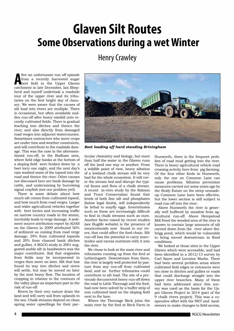
After an unfortunate run off episode from a recently harvested sugar beet field in the Upper Glaven
catchment in late December, Ian Shep-herd and myself undertook a roadside tour of the upper river and its tribu-taries on the first bright day of Janu-ary. We were aware that the causes of silt load into rivers are multiple. There is occasional, but often avoidable sud-den run-off after heavy rainfall onto re-cently cultivated fields. There is gradual leaching into ditches and thence the river, and also directly from damaged road verges into adjacent watercourses. Sometimes contractors who move crops are under time and weather constraints, and will contribute to the roadside dam-age. This was the case in the aforemen-tioned run-off, in the Bodham area, where field edge banks at the bottom of a sloping field were broken down by a beet lorry one night, and the next day’s rain washed some of the topsoil into the road and thence the river. Other causes not discussed here are bank damage by cattle, and undermining by burrowing signal crayfish (not our problem yet!).
There is some debate about how much silt comes from cultivated topsoil, and how much from road verges. Larger and wider agricultural vehicles together with beet lorries and increasing traffic on narrow country roads in the winter, inevitably leads to verge damage. A sedi-ment source attribution report by ADAS on the Glaven in 2009 attributed 50% of sediment as coming from road verge damage, 29% from cultivated topsoils and 20% from channel bank ditches and gullies. A RGCG study in 2001 sug-gested arable silt in headwaters was the major contributor. Soil that originates from fields may be incorporated in verges then move on later. Silt that has found its way into ditches and rivers will settle, but may be moved on later by the next heavy flow. The location of cropping in relation to the contours of the valley plays an important part in the risk of run-off.
Rivers by their very nature drain the land and will carry soil from uplands to the sea. Chalk streams depend on clean spring water upwellings for their par-
ticular chemistry and biology, but more than half the water in the Glaven runs off the land one way or another. From a wildlife point of view, heavy siltation of a lowland chalk stream will be very bad for the whole ecosystem. It will cov-er the stream bed and disrupt the typi-cal fauna and flora of a chalk stream. A recent in-vitro study by the Salmon and Trout Conservation found that levels of both fine silt and phosphates (below legal limits), will independently be lethal to mayfly eggs. Invertebrates such as these are increasingly difficult to find in chalk streams such as ours. Another factor raised by recent studies (see Buglife website) is the presence of neonicotinoids now found in our riv-ers, that could affect the food chain. Silt run-off has the potential to carry insec-ticides and excess nutrients with it into the river.
We chose to look at the main river and tributaries running up from the ford at Letheringsett. Downstream from there, the river is largely well protected by pas-ture from any run-off from cultivated land, and no further tributaries could contribute to silt load. The site of a pre-viously documented heavy run-off down the road to Little Thornage and the ford, had now been solved by a buffer strip of non cultivated land on the sloping field next to the lane.
Where the Thornage Beck joins the main river by the ford at Beck Farm in
Hunworth, there is the frequent prob-lem of road mud getting into the river. There is heavy agricultural vehicle road crossing activity here from pig farming. Of the four other fords in Hunworth, only the one on Common Lane can cause problems. Siltation prevention measures carried out some years ago by the Stody Estate on the steep unmade-up Common Lane have been effective, but the lower section is still subject to road run-off into the river.
Above Hunworth the river is gener-ally well buffered by meadow from ag-ricultural run-off. Above Hempstead Mill Pond the wooded area of the river is known to contain large amounts of silt carried down from the river above Sel-brigg pond, which would be vulnerable to being moved downstream in flood conditions.
We looked at those sites in the Upper Glaven which were accessible, and had been identified in a 2012/13 survey by Carl Sayer and Lorraine Marks. There had been several problem areas where cultivated field edges or entrances were too close to ditches and gullies or roads that could discharge straight into the upper river branches. Many of these had been addressed since this sur-vey was used as the basis for the Up-per Glaven Project in 2014 (part of the 9 chalk rivers project). This was a co-operative effort with the NRT and land-owners to make changes to field access,
Glaven Silt Routes Some Observations during a wet Winter
Henry Crawley
Beet loading off hard standing Briningham

Spring 2018 5
introduction of grassland buffer strips etc. It was pleasing to see the modifica-tions that had been made coping with the very wet January. There were some other areas that still need addressing
and the RGCG plan to revisit this sur-vey later in the year, and hope to work with landowners and others on some outstanding problems.
Thornage Beck is well buffered by
woodland or pasture up to and through Thornage to Brinton. However it is of-ten observed to be very turbid at times of high flow. The main Beck continues up to Gunthorpe where it originates from the Hall Lake. Throughout the up-per reaches there is pasture buffering, but the risk sites are at road crossings where mud on the road from whatever source can run into the river in heavy rain. This was also evident in Brinton village. Muddy seepage off a sloping field near the Old School on the Stody road, and from fields on the Sharrington road has easy access to the streams where they go under the road. This is also a problem at the Lobb’s valley stream that enters the village under the descending Briningham road, with potential for ag-ricultural run-off from a field entrance.
The other main tributary is the Burgh Beck that arises in Melton Constable and another branch in Briningham, meeting at Stody, and both pastured in the lower stretches. It is not known to be silt laden in heavy rain.
These observations do make me won-der what our rivers and streams were like before metalled roads replaced muddy tracks, and fords were largely replaced with bridges or pipes. Perhaps former ag-ricultural cultivation, being more limited and piecemeal, meant that there was less mobile soil to wash into watercourses. Silt is of course not a new problem (see Newsletter Autumn 2014). The current situation is that once muddy water starts running down a lane, side-cuts can ab-sorb some, but at the bottom of a slope, where roads cross watercourses, it’s dif-ficult to keep it out of the stream. The Highways Departments generally see their responsibility as being to avoid road flooding, and are perhaps less interested as to where the road run-off ends up. I’m sure some roadside cuts and drains could be better designed to reduce direct access to rivers.
Since the publication of our revamped Strategy for 2016-20, which refocused on the current risks to the River and our priorities in trying to deal with them, it is still clear that water borne soil erosion of the land and silt deposition is still the major threat to the sustainability to a chalk stream such as the Glaven. The Committee have been discussing what we can do to change this, and would like to work with landowners and others, as has been done in the past, to identify problem areas which can be improved. Much has been done, but changes in agricultural practice and weather pat-terns are not helping. The current Gov-ernment process of redefining the policy for agricultural environmental support will have a significant effect, and hope-fully the needs of both farming and wildlife can be met.
Top: easy run off into Lobb’s stream off Briningham Road, Brinton.Middle: field entrance at low end of field at Brinton-site of muddy seep-age onto road close to streamBottom: top end of Bodham stream, buffering from arable run-off, bet-ter on left side.

RGCG Newsletter6
The Glaven Valley Conservation Area (GVCA) was designated as such in 1978, and came about
through the foresight and persever-ance of the first Chairman of the newly formed North Norfolk District Council. The designation was based upon the beautiful and varied land-scapes within the valley, and the character of its villages. It stretches from the coast to the headwaters of the river. It encompasses the tribu-taries as well as the main river, and the boundary extends to a consider-able extent to east and west, from the south to north in the same direction of flow as the river, and becomes tidal as it approaches the Blakeney lagoon and enters the sea.
The coastal Area of Outstand-ing Natural Beauty (AONB) ex-tends south to Letheringsett par-ish boundary at Little Thornage. As such there is an overlap between the AONB running east west, and the GVCA running in a north south direction. The designation of the AONB and its boundary came in April 1968, and as such celebrates its 50th anniversary this year. When the GVCA was designated there would have been a discussion on why the overlap; and the propos-ers argued because of the charac-ter of the river valley, it has to be seen as a whole. We consider that was the correct decision, and it has become more so with time, particu-larly with increased knowledge and awareness of the interrelationship between landscape and wildlife.
With the abolishment of local ‘high value’ designation, the norm is now for any rural conservation area to be small. In planning inquiries an Inspector can get ‘itchy’ on seeing the size of the GVCA; the GVCA sur-vived that change as it has an inde-pendent legal provenance. However, unlike the Core Strategy adopted in 2008, the successor Local Plan will see a review of the GVCA. Infor-mation is being gathered now, and there will be a public consultation this summer on the GVCA.
The Glaven Valley Conservation Area:A Consultation on the designation for planning purposes
Ian Shepherd
Upper: Lower Bayfield Meadows – new scrapes completed 2015.Lower: Dexter cattle grazing restored meadows at Lower Thornage.
Opposite page upper: Holt Lowes – wetland restoration. Opposite page lower: Woody river stretch below Hempstead Mill.

Spring 2018 7
The Core Strategy of 2008 was brilliant and ahead of its time on Policy EN 9 on Biodiversity, in par-ticular the six page appendix on the ecological network and the impor-tance of the North Norfolk Rivers. However a considerable expansion over the past five or six years on the knowledge of the Glaven as part of the wider ecological network has led us to the view that biodiversity and landscape are interlocking and inte-gral to each other. Further there is a risk of insufficient weight in policy considerations in recognising that the sum of the two aspects is great-er than either alone; particularly for river systems.
We add that the National Plan-ning Policy Framework is under re-view at present, the first time since it was adopted in March 2012. The sections are set out in short gener-al statements, and that for Section 11, ‘Conserving and enhancing the natural environment’ is par for the course. It has five pages to provide guidance. This does include both landscape and biodiversity, and see paragraphs 109 and 115 for the general links. Also see paragraph 117 on planning for landscape scale across local authority boundaries as the first bullet point; the sec-ond and third bullet points on the identification of and the restoration of priority habitats, and ecological networks, etc.
The years since the NPPF was in-troduced have seen the realisation of the importance of the restoration of farmland ponds, particularly at a watershed, that can strengthen the wildlife connection between one riv-er system and the next, in the case of the Glaven headwater and that of the Bure. They act as stepping stones over the largely arable land which lies between the two. Our first report on this was the RGCG News-letter of Autumn 2016, front page and page 2; and followed by an arti-cle In Autumn 2017, with the article at pages 3 and 4. If you can’t find your copy, then go to our web site and click on Newsletters; they are all held there. Finally when the con-sultation on the GVCA takes place this summer, we hope that you will respond. There is a very real danger that the designation of the GVCA will be abolished, and in landscape terms there will be no special status in the planning system for the val-ley from Letheringsett Ford to the headwaters of the river.

RGCG Newsletter8
As part of the Norfolk Ponds Proj-ect and very much linked to the RGCG’s wider upper Glaven con-
servation strategy we have been re-storing ponds in the Bodham to Ba-consthorpe area over the last few years and studying the results.
Since the 1960s/70s period Norfolk farmland ponds have become highly overgrown by trees and bushes, with negative impacts for species due to a lack of aquatic plant habitat and be-cause overgrown ponds afford very harsh (anoxic) conditions for aquatic species. Thus the Norfolk Ponds Proj-ect has re-instated management and undertaken major scrub and sediment removal at many farmland ponds. Since 2012 some ten ponds (largely old marl pits) have been restored in the Bodham-Baconsthorpe area and to say the results have been positive and dramatic would be an understatement! A team of UCL PhD and MSc students have been studying invertebrates, plants, amphibians, pollinators, fishes and farmland birds all of which have shown major improvements. Also lo-cal dragonfly expert Bernard Dawson has revealed the restored ponds to be highly rich in this group.
After restoration, which typically takes place in September-November, restored farmland ponds slowly fill up again and by spring the waters are usu-ally clear and oxygen-rich. Then, in sum-mer, aquatic plants really start to thrive (Fig. 1) and when this happens inver-tebrates grow in number and richness and when mayflies (and other insects) emerge from the ponds they feed the birds. It is not an unusual sight to see 10-20 swallows, swifts and house mar-tins swooping over our ponds, swish-ing past your head into insect smoke-stacks. Amphibians increase in number after a few years and we have seen frog populations go up from a few individu-als to hundreds maybe thousands of animals. With dragonflies, between just two restored ponds at Beckett’s Farm, Baconsthorpe some twenty-two species (Fig. 2) have been recorded, even in-cluding a visit (holiday from the Broads) from the rare and magnificent Norfolk Hawker.
Conserving Glaven farmland ponds and the Great Twin Pond Dig project
Dr Carl Sayer (UCL)
Fig1. Shooting Close Pond Before (above) and After (below) restoration by scrub and sediment removal (photos: Carl Sayer)

Spring 2018 9
But there is more to ponds than just being points of high biodiversity as ponds contribute a great deal from a landscape perspective. Ponds can be seen as stepping stones and when they are considered with other old farmland features such as hedges, lokes and patches of old woodland they can be seen as vital components within an eco-logical network allowing species to more fully utilise and move through the land-scape. For example, mayflies and oth-er insects that emerge from ponds are unlikely to come out in high numbers in all ponds on the same day, so typi-cally offer a shifting resource and birds will move between ponds to find food. Equally, species that like specific pond habitat conditions (e.g. dragonflies, am-phibians, water beetles) may not always find what they need in any one pond in all years and so they move from pond to pond. Therefore networks of ponds linked to hedges and old habitats is the way to go for farmland conservation.
Since February 2017 a group of lo-cals have been monitoring four ponds in Bodham as part of the “Great Twin Pond Dig” project which is twinning both ponds and people between Nor-folk and Lancashire. This project, the brainchild of UCL PhD student Helen Greaves and funded by the British Ecological Society, is trialing an “Adopt a Pond” idea and has the aim of re-connecting people and farmers with their local farmland ponds and with pond ecology and restoration. So far the Bodhamers have done an awesome job of surveying the changing environ-ment and species of the ponds (Fig. 3). They have measured water chemis-try, hunted for amphibians, recorded plants and even set up camera traps and recorded visiting mammals. In-deed a resulting film entitled “Animals Around The Ponds” was short-listed at Cannes. In June 2017 they took part in a ‘Bioblitz’ event which was a great success and featured a barbe-cue, much cake and the attendance of several local natural history experts. Two ponds were restored in September 2017 (with 2 left as ‘control’ ponds) and the team are out studying the changes. The restorations went well and we are all expecting amazing results.
This year’s RGCG AGM (details on front page) will be followed by a talk on the Norfolk Ponds Project (by Carl Sayer) as it relates to the wildlife of the upper Glaven valley. It will feature film footage and even underwater sound recordings. This will be followed by a short tour of some of the ponds. We so hope you can come along, as by June the ponds will be at their peak in terms of both biodiversity and beauty, or should I say booty.
Upper: Fig 2. Scarce Emerald Damselfly at Becket’s Farm Pond, Baconsthorpe (photo: Bernard Dawson)
Lower: Fig 3. The Great Twin Pond Dig team on their first gathering at a Bodham pond (photo: Carl Sayer)

RGCG Newsletter10
MSc survey of floodplain ponds at Bayfield
Harry Stone
Harry Stone, a part-time MSc Aquat-ic Science student at UCL, tells the story of his masters research project comparing floodplain pond and river communities of aquatic plants and water beetles. He poses the ques-tion: why are floodplain ponds im-portant?
Most of our rivers have become boring, ecologically and morpho-logically speaking. Centuries of
straightening and simplification have robbed them of their complexity and floodplain connectivity. Healthy river
systems contain a messy array of beau-tiful back channels, resplendent relic meanders, omnifarious oxbows and flourishing floodplain ponds. This rich messiness is created as rivers crash and migrate across the land, driven by natural processes like floods, beavers, trees and even emergent plants such as the branched bur-reed (Spargani-um erectum).
Essentially stepping in for these lost and diminished processes, custodians of the River Glaven have been revers-ing the national trend towards boring rivers by creating and protecting a va-
riety of floodplain pond and backwa-ter habitats. Last year I set out to an-swer the question: how do constructed floodplain ponds affect river-floodplain diversity? My work focuses on some 10+ sites in the mid to lower Glaven valley, including four ponds (e.g. Fig. 1) recently created by the Norfolk Riv-ers Trust at Bayfield and Wiveton.
With the help of Carl Sayer, Norfolk Rivers Trust and my faithful compan-ion for the summer, MSc student Jack Greenhalgh (Fig. 2), I have analysed seven floodplain pond sites so far, com-paring each one to its nearby stretch of

Spring 2018 11
river. Of the sixty-four identified aquat-ic plant species, over half were found only in ponds, compared to just five species (8%) which were only found in and on the banks of the river. These results underline the importance of ponds to overall botanical diversity in floodplain environments (Fig. 3).
The ponds appear similarly im-portant for water beetles. Of the fifty species identified thus far, 46% were exclusive to ponds, compared to 17% of which were exclusive to the river. However, these results are heavily in-fluenced by one particular stretch of the Glaven which was at least twice the depth of every other river site. This site, just to the south of Wiveton, had
the highest water beetle abundance of all the sites – 204 specimens netted in just three minutes! It was also at this site that we found, presumably crawl-ing among the deep bed of starwort, ten very rare riffle beetles. Unlike their more familiar diving cousins, riffle bee-tles do not swim or surface to breathe. According to the NBN Atlas, Oulimnius troglodytes has never been recorded on the Glaven before, and was last re-corded in Norfolk in 1997.
This deep stretch of river might have complicated my results, but perhaps it also points towards the importance of river morphological heterogeneity to overall biodiversity. Or in other words, the more a river system is made up of
dissimilar parts, the more rich and ex-citing the flora and fauna is.
I’m hoping to squeeze in at least three more backwater sites this summer. If you have any comments or feedback please get in touch with me: [email protected]
Opposite: Figure 1. A lovely flood-plain pond created in 2014 by the Norfolk Rivers Trust at Bayfield as part of the Nine Chalk Rivers Proj-ect (photo: Carl Sayer, 2017)
This page, upper: Figure 2. MSc students Harry Stone (Right) and Jack Greenhalgh (Left) hunting for water beetles in a sample from a Glaven pond at Bayfield (photo: Carl Sayer, 2017)
This page, lower: Figure 3. A micro-jungle of brooklime (Veronica beccabunga) providing complex three-dimensional habitat (photo: Harry Stone, 2017)
Plague immunity in a Spanish population of White Clawed Crayfish
Aphanomyces astaci, or crayfish plague, classified as one of the 100 World´s Worst Invasive Alien Species, comes in five forms ranging in virulence. It origi-nates from North America and is car-ried on the highly invasive Red Swamp and Signal Crayfish, which are immune to the fungi-like pathogen. These spe-cies have been bought to Europe as food sources and in the pet trade, and have made their way in to European watercourses, decimating plants, fish and our native crayfish populations. When exposed to the plague, the Ameri-can crayfish’s immune system creates melanin in response, which is consid-ered both “fungitoxic and fungistatic”. Perhaps only by chance, and a long pe-riod of coevolution, the crayfish are able to survive an outbreak. In order to find out more about the susceptibility and resistance to the plague in populations of our native White Clawed Crayfish, a study was conducted on eight isolated populations in Spain where each popu-lation was exposed to the highly virulent strain of A. astaci., called strain “Pc”.
Five males from each of the eight populations (forty crayfish in total) were taken and acclimatised for two weeks in aquaria under the same conditions. All crayfish were examined before being the start of the experiment and showed no sign of melanisation and no pres-

We aim to work in friendly collaboration with landowners and farmers, conservation
organisations and relevant public bodies.
River Glaven Conservation GroupHenry Crawley Chairman 01263 713306
email: [email protected]
Ian Shepherd Secretary 01263 713370
Anne Rolfe Treasurer & Membership Secretary
Web site www.riverglaven.co.uk
ence of A. astaci. The crayfish were exposed to the plague steadily for 120 days, with a control tank being kept to monitor those not exposed.
All crayfish exposed to the pathogen started dying from day 7, except for the population from La Muga which all survived the full 120 day experiment. Three from Falgars and two from Done-ztebe also survived the full experiment, showing some form of resistance!
The immune population from the La Muga area showed a range of large macroscopic AND small microscop-ic melanised spots, a reaction to the plague, expressed on the legs and tails. The few survivors from the other popu-lations showed only small microscopic, weakly melanised spots but this dem-onstrates that they are able to resist it to a certain extent.
It is thought that the La Muga popu-lation may have a gene that has helped them survive, as they appear to be a dif-ferent genetic lineage to the other pop-ulations. An alternative theory is that the constant exposure to high densities of Red Swamp crayfish in the la Muga area has promoted this immune pheno-type. If this is the case, they have been thought to have evolved rapidly, as they have only been exposed to the plague since the 1990s.
Further work will be done to under-stand the dynamic, hopefully providing us with a solution to protect our stron-gest remaining population in the South, the Glaven White Clawed Crayfish. In the meantime everything possible must be done to protect them, biosecurity and water quality being our key issues. The silt in the upper Glaven is a real threat to the habitat as well as the pollutants running off our roads and into the river. Watch this space for the rejuvenation of the Upper Glaven silt project!
Ursula Juta, Norfolk Rivers Trust
Reference: Resistance to the crayfish plague, Aphanomyces astaci(Oomycota) in the endangered freshwater crayfish spe-cies, Austropotamobius pallipesLaura Martín-Torrijos, Miquel Campos Llach, Quim Pou-Rovira, Javier Diéguez-Uribeondo Published: July 27, 2017 https://doi.org/10.1371/journal.pone.0181226
Vole Breeding Success
Robin Combe has been having great success in captive breeding Water Voles at Natural Surroundings last year. He obtained breeding pairs from Devon, and with care and much feed-ing, they have produced 57 offspring. 28 were returned to Devon and 29 into the Lower Glaven. Robin would like to get some Water Vole surveying done this year. Please contact Robin or Henry Crawley if you are interested in helping.
Photo: Chris Jarvis
Crayfish Update
The protection of the local white clawed crayfish (WCC) in Norfolk Rivers and in particular the Glaven which has an isolated healthy popula-tion is overseen by the Crayfish Group which meets regularly. As has been reported in previous newsletters, the ‘ark project’ to introduce WCC to iso-lated sites as an insurance policy is a major plank in the work of the group. Last years surveys to assess the suc-cess of the ark project are promising but at an early stage. Further trans-fer from the Glaven population to new ark sites is planned this year. Sadly the Signal crayfish and their associat-ed plague is remorselessly spreading through other Norfolk Rivers, which makes this work ever more important.
Himalayan Balsam Control
Our annual volunteer days to Bash the Balsam will happen sometime
in July and August when flowering makes for easy identification. There are a few sites which still need to be cleared. Please let Henry Crawley know by phone or email if you would like to helpWe have signed up to an approved trial to introduce a specific rust which may weaken and control the inva-siveness of balsam.