Embed Size (px)
Citation preview

NFIP IMPACTS IN AGRICULTUREEDEN ANNUAL MEETING
OCTOBER 23, 2014
Pat Skinner [Separate slides]LSU AgCenter - [email protected]
Simin HoGovernment Accountability [email protected]

SEE LSU AGCENTER SLIDES FOR INFORMATION
PRESENTED BEFORE THE FOLLOWING SLIDES.
GAO DISCLAIMER
The opinions and views expressed in these slides are the author’s alone and are not intended to reflect GAO institutional views.


WHY GAO CONDUCTED THE STUDY
� FEMA’s National Flood Insurance Program has been subject to many changes in an effort to improve its finances after sustaining heavy losses in recent years.
� Flood map updates (one of the changes) could place large portions of agricultural areas in high-risk flood zones, or Special Flood Hazard Areas (SFHAs) and subject agricultural structures to building requirements (e.g., elevation and floodproofing).
� GAO was asked by congressional requesters to evaluate the possible effects of such changes on farmers and rural residents.

METHODOLOGY: IDENTIFYING
AGRICULTURAL FLOODPLAINS
� Because FEMA does not distinguish between urban or rural areas, we estimated the location of rural communities and agricultural areas in riverine SFHAs across the United States.
� Data used� Census Bureau � USDA Atlas of Rural and Small Town America � FEMA’s floodmap data, focusing on riverine floodplains

RURAL AND AGRICULTURAL RIVERINE
SPECIAL FLOOD HAZARD AREAS

METHODOLOGY: SELECTED COMMUNITIES
To more fully understand farmers’ experiences in dealing with building requirements, we selected 8 case study communities based on the following criteria:
� Communities that contain at least some agricultural land located SFHAs in riverine areas
� Communities with crop or livestock production requiring farm structures for nearby on-farm processing
� Geographic variations

8 SELECTED COMMUNITIES
Selected NFIP community Number of farmers and productionNumber of rural residents
Number of agricultural lenders/developers
Sutter County, CA8; Produced walnuts, rice, root stock, prunes, plumbs, crop protectant, and fertilizer
None 1 lender
Yolo County, CA4; Produced wine, wine grapes, alfalfa, wheat, tomatoes, walnuts, corn, and seed crops
4 1 lender /1 developer
Rapides Parish, LA3; Produced rice, crawfish, grain sorghum, wheat, corn, soybeans, and cotton
2 1 lender
St. Landry Parish, LA2; Produced rice, crawfish, soybeans, and wheat
None 1 lender /1 developer
Duplin County, NC4; Produced hogs, turkey, chicken, corn, soybean, cotton, and wheat
None
Tyrrell County, NC None None 1 lender
Cass County, ND2; Produced corn, soybeans, and wheat
None 1 lender
Walsh County, ND1; Produced spring wheat, corn, pinto beans, soybeans, sugar and beets
4
Total 24 106 lenders, 2 developers
Source: GAO. | GAO-14-583
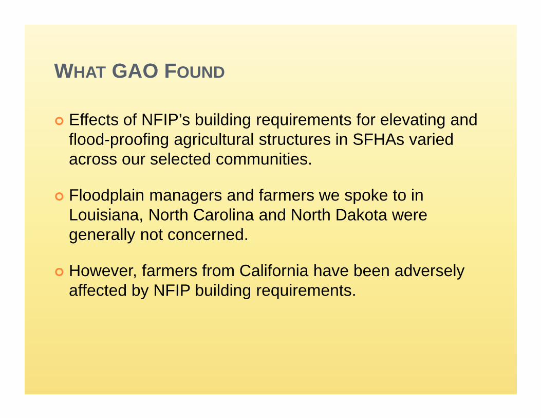
WHAT GAO FOUND
� Effects of NFIP’s building requirements for elevating and flood-proofing agricultural structures in SFHAs varied across our selected communities.
� Floodplain managers and farmers we spoke to in Louisiana, North Carolina and North Dakota were generally not concerned.
� However, farmers from California have been adversely affected by NFIP building requirements.

WHAT GAO FOUND
Two key factors may partly explain the differing views of farmers in California as compared to those from the other three states.
1. Vast floodplains: SFHA areas in the two California communities have greatly increased in size in recent years as a result of map updates and de-accredited levees.
2. Deep flood depths: Building requirements are difficult to meet in these communities because the flood depth is relatively higher than the other communities in our case studies.

WHAT GAO FOUND
� Farmers in areas with vast floodplain and high flood depths have had to “workaround” FEMA’s building requirements as they try to expand their businesses. Examples of these workarounds:
� Quickly built facilities before flood map revisions placed their farms in SFHAs.
� Instead of building new structures, only make incremental additions or repairs that were below NFIP’s substantial improvement threshold for building requirements.
� However, workarounds may not fully address the long-term expansion needs of these farmers.
� The workarounds may ultimately defeat the purpose of the building requirements because they may increase the risks of flood damage to the structures.

WHAT GAO FOUND
� FEMA acknowledged the need for additional guidance that covers all of the different types of agricultural structures and reflects recent developments in the size and scale of farm operations. The current guidance is more than 20 years old.
� Other agricultural areas across the country also have vast floodplains and deep flood depths—some up to 37 feet—including Southwest Illinois, Northeast Arkansas, Southwest Mississippi, Southeast North Carolina, and Northwestern Missouri. Farmers in these areas may face similar challenges in complying with FEMA building requirements.
� Additional and more comprehensive guidance would allow FEMA to better respond to recent developments and structural needs in vast and deep floodplains.

RECOMMENDATION
� GAO recommended that FEMA update existing guidance to include additional information on and options for mitigating the risk of flood damage to agricultural structures to reflect recent farming developments and structural needs in vast and deep floodplains.
� Updated guidance would help farmers in identifying feasible alternatives to complying with building requirements in expansive floodplains with deep flood depths.

SEE LSU AGCENTER SLIDES FOR INFORMATION
PRESENTED AFTER THE PRECEDING SLIDES.
GAO DISCLAIMER
The opinions and views expressed in these slides are the author’s alone and are not intended to reflect GAO institutional views.

ADDITIONAL INFORMATION
GAO Report (GAO-14-583)
� National Flood Insurance Program: Additional Guidance on Building Requirements to Mitigate Agricultural Structures’ Damage in High-Risk Areas is Needed
� http://www.gao.gov/search?q=GAO-14-583