Embed Size (px)
Citation preview
NH Geographic Information System (GIS) Committee
Established under HB377
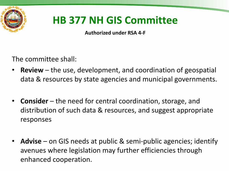
HB 377 NH GIS Committee Authorized under RSA 4-F
The committee shall:
• Review – the use, development, and coordination of geospatial data & resources by state agencies and municipal governments.
• Consider – the need for central coordination, storage, and distribution of such data & resources, and suggest appropriate responses
• Advise – on GIS needs at public & semi-public agencies; identify avenues where legislation may further efficiencies through enhanced cooperation.
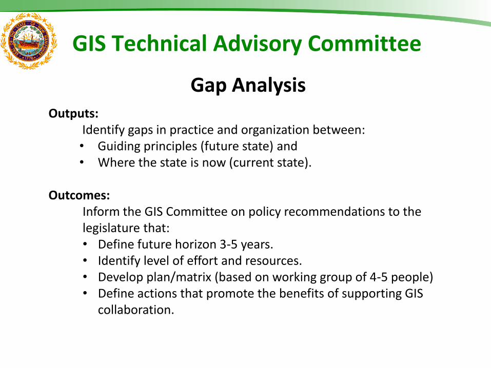
Outputs: Identify gaps in practice and organization between: • Guiding principles (future state) and • Where the state is now (current state).
Outcomes:
Inform the GIS Committee on policy recommendations to the legislature that: • Define future horizon 3-5 years. • Identify level of effort and resources. • Develop plan/matrix (based on working group of 4-5 people) • Define actions that promote the benefits of supporting GIS
collaboration.
GIS Technical Advisory Committee
Gap Analysis
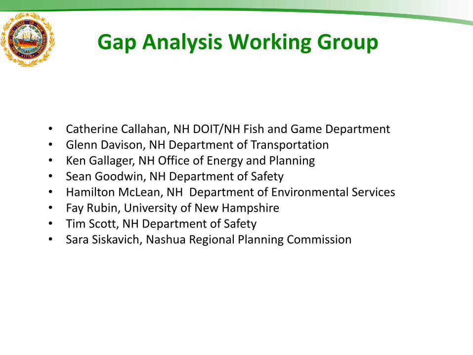
• Catherine Callahan, NH DOIT/NH Fish and Game Department • Glenn Davison, NH Department of Transportation • Ken Gallager, NH Office of Energy and Planning • Sean Goodwin, NH Department of Safety • Hamilton McLean, NH Department of Environmental Services • Fay Rubin, University of New Hampshire • Tim Scott, NH Department of Safety • Sara Siskavich, Nashua Regional Planning Commission
Gap Analysis Working Group
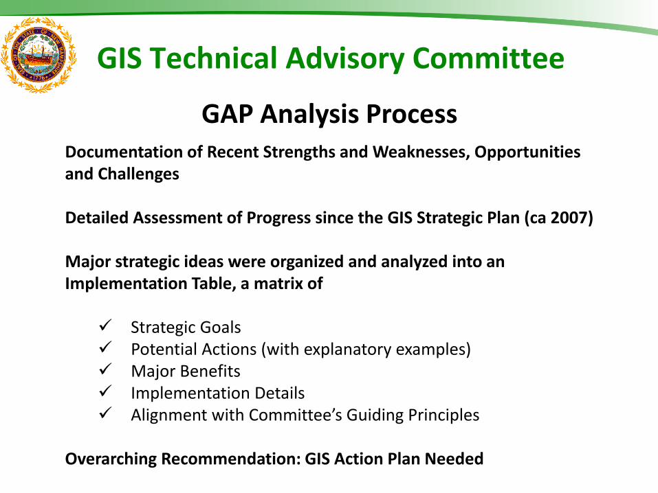
Documentation of Recent Strengths and Weaknesses, Opportunities and Challenges Detailed Assessment of Progress since the GIS Strategic Plan (ca 2007) Major strategic ideas were organized and analyzed into an Implementation Table, a matrix of
Strategic Goals Potential Actions (with explanatory examples) Major Benefits Implementation Details Alignment with Committee’s Guiding Principles
Overarching Recommendation: GIS Action Plan Needed
GIS Technical Advisory Committee
GAP Analysis Process

The GTAC proposes that a formal subcommittee of the GTAC be established to prepare a two-year Action Plan. Outputs
A sequence of steps that must be taken, or activities that must be performed effectively, for a strategy to succeed. Three major component areas:
• Specific tasks that will be completed and by whom • Time horizon when tasks will be completed • Capital and human resources needed for specific activities to be
completed
Required Action
GIS Committee adopts GTAC recommendations and commits to identifying resources to support the Strategies listed.
GIS Technical Advisory Committee
Recommendation
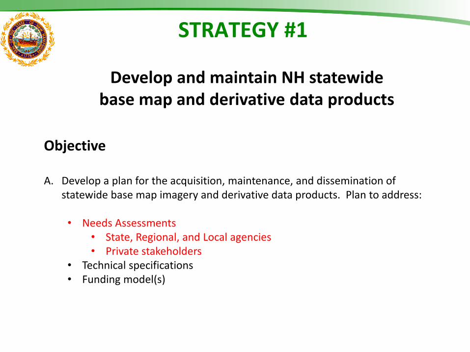
STRATEGY #1
Develop and maintain NH statewide base map and derivative data products
Objective A. Develop a plan for the acquisition, maintenance, and dissemination of
statewide base map imagery and derivative data products. Plan to address: • Needs Assessments
• State, Regional, and Local agencies • Private stakeholders
• Technical specifications • Funding model(s)
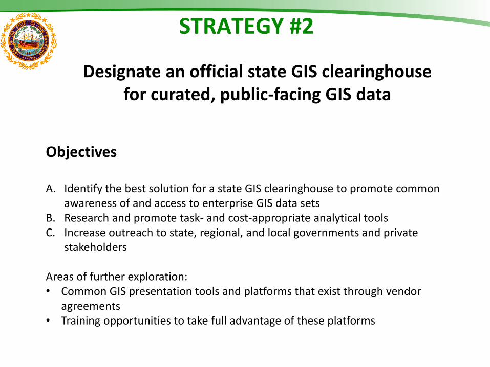
STRATEGY #2
Designate an official state GIS clearinghouse for curated, public-facing GIS data
Objectives A. Identify the best solution for a state GIS clearinghouse to promote common
awareness of and access to enterprise GIS data sets B. Research and promote task- and cost-appropriate analytical tools C. Increase outreach to state, regional, and local governments and private
stakeholders
Areas of further exploration: • Common GIS presentation tools and platforms that exist through vendor
agreements • Training opportunities to take full advantage of these platforms
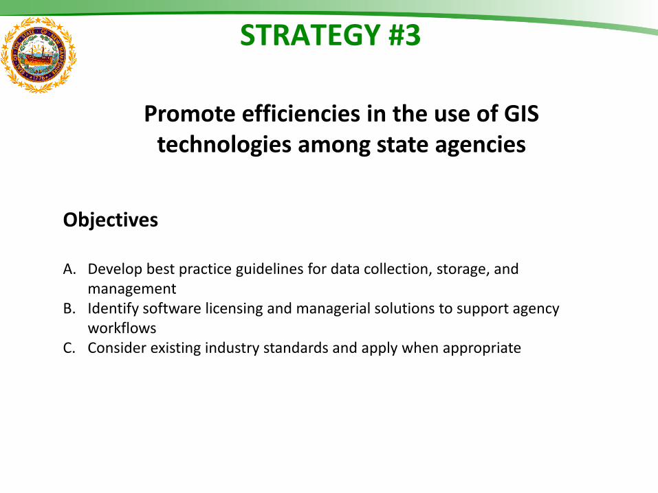
STRATEGY #3
Promote efficiencies in the use of GIS technologies among state agencies
Objectives A. Develop best practice guidelines for data collection, storage, and
management B. Identify software licensing and managerial solutions to support agency
workflows C. Consider existing industry standards and apply when appropriate
STRATEGY #4
Enhance statewide GIS governance and policies to guide best practices
Objectives A. Renew GTAC charge and outreach plan B. Document legal guidance on public records law as it pertains to GIS data,
including essential requirements and specific exemptions.
Summary of Recommendations: Two-Year GIS Action Plan
Outputs 1. A sequence of steps or activities that must be taken to support each Strategy
with three major components: • Specific tasks & by whom • Time horizon • Capital & human resources needed
Recommended Actions 1. GIS Committee adopts GTAC recommendations and commits to identifying
resources to support each of the Strategies 2. GIS Committee directs GTAC to achieve Strategy 1 first due to the budgetary
timeline, broad support and need for these data sets, and the likelihood of successful completion
3. GIS Committee reports to Legislature as required on the Action Plan progress Resource requirements
1. Assigned point of contact for overall coordination 2. GTAC working group or outside resources 3. Availability of agency staff resources or funding of outside resources
Questions ?
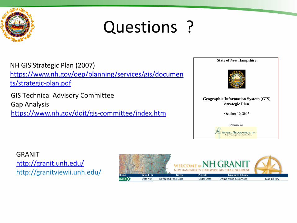
NH GIS Strategic Plan (2007) https://www.nh.gov/oep/planning/services/gis/documents/strategic-plan.pdf
GRANIT http://granit.unh.edu/ http://granitviewii.unh.edu/
GIS Technical Advisory Committee Gap Analysis https://www.nh.gov/doit/gis-committee/index.htm
Older versions of slides that were changed follows …
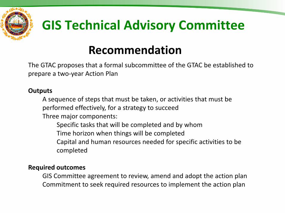
The GTAC proposes that a formal subcommittee of the GTAC be established to prepare a two-year Action Plan Outputs
A sequence of steps that must be taken, or activities that must be performed effectively, for a strategy to succeed Three major components:
Specific tasks that will be completed and by whom Time horizon when things will be completed Capital and human resources needed for specific activities to be completed
Required outcomes
GIS Committee agreement to review, amend and adopt the action plan Commitment to seek required resources to implement the action plan
GIS Technical Advisory Committee
Recommendation
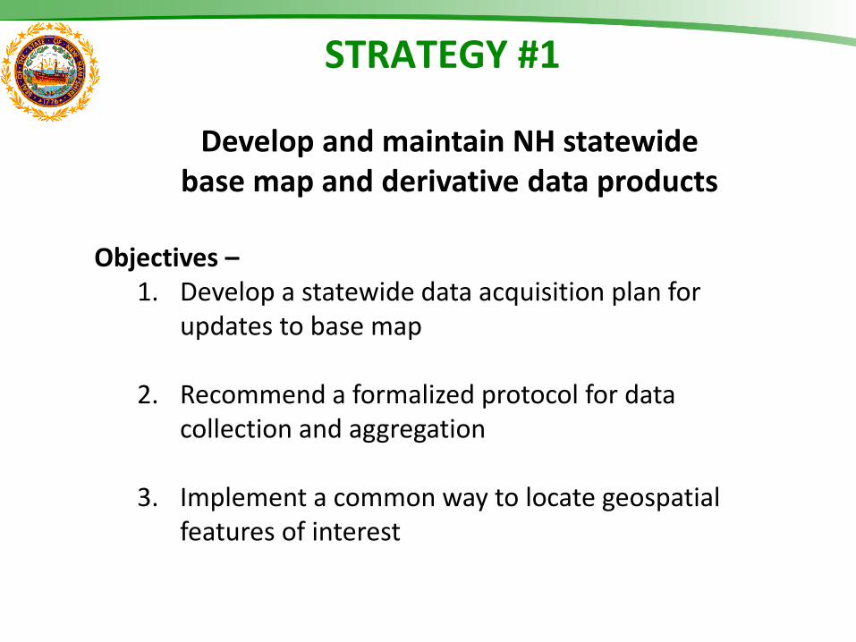
Objectives – 1. Develop a statewide data acquisition plan for
updates to base map
2. Recommend a formalized protocol for data collection and aggregation
3. Implement a common way to locate geospatial features of interest
STRATEGY #1
Develop and maintain NH statewide base map and derivative data products
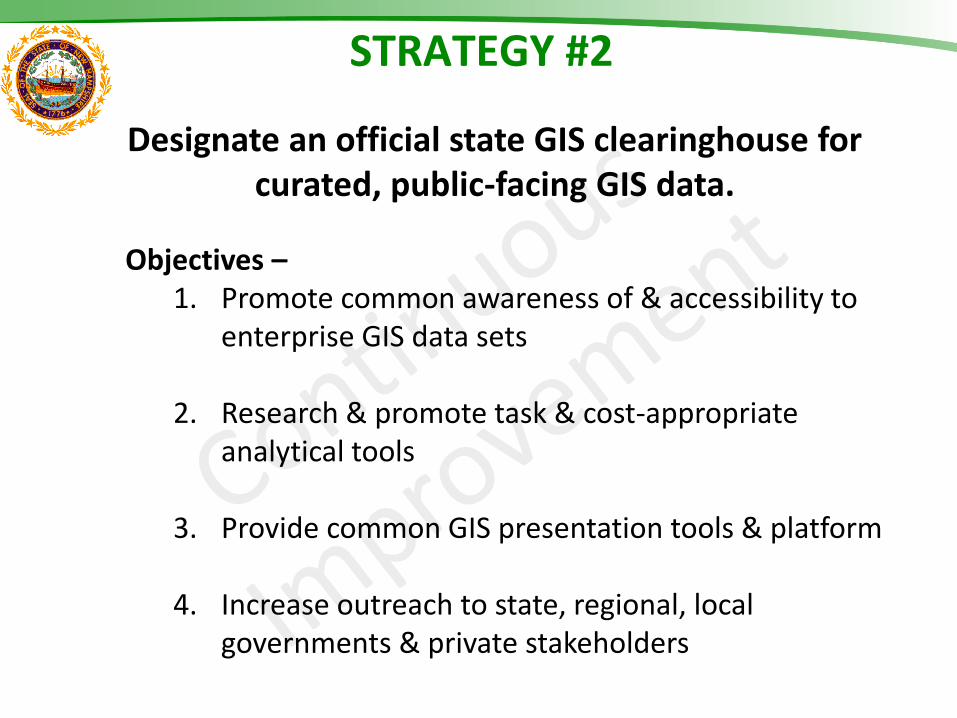
STRATEGY #2
Designate an official state GIS clearinghouse for curated, public-facing GIS data.
Objectives – 1. Promote common awareness of & accessibility to
enterprise GIS data sets
2. Research & promote task & cost-appropriate analytical tools
3. Provide common GIS presentation tools & platform
4. Increase outreach to state, regional, local governments & private stakeholders
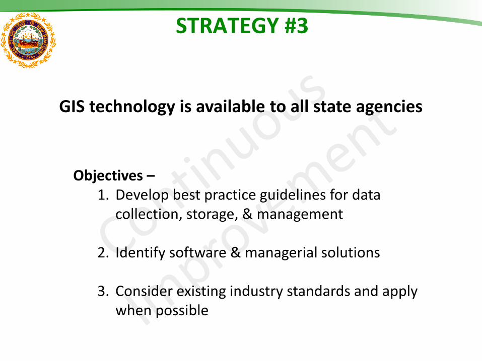
STRATEGY #3
GIS technology is available to all state agencies
Objectives – 1. Develop best practice guidelines for data
collection, storage, & management
2. Identify software & managerial solutions
3. Consider existing industry standards and apply when possible
STRATEGY #4
Objectives – 1. Renew GTAC charge and outreach plan
2. Elucidate uniform legal guidance with respect
to GIS and NH public records law
Enhance statewide GIS governance and policies to guide best practices
Summary of Recommendations: Two-Year GIS Action Plan
Outputs 1. A sequence of steps or activities that must be taken
for each objective to support respective strategy. 2. Three major components:
• Specific tasks & by whom • Time horizon • Capital & human resources needed
Required outcomes 1. GIS Committee review, amend & adopt 2. Identify available resources to implement 3. Report to Legislature
Resource requirements 1. Assigned point of contact for overall coordination 2. GTAC working group or outside resources 3. Availability of agency staff resources or funding of
outside resources


![Attachments [Plurilateral Agreements in General] [ITA] · Attachments [Plurilateral Agreements in General] 1. Multilateral Agreements and Plurilater al Agreements on Trade-related](https://img.pdfslide.net/doc/110x75/5f098b887e708231d42756e4/attachments-plurilateral-agreements-in-general-ita-attachments-plurilateral.jpg)