Embed Size (px)
Citation preview
Nillumbik Green Wedge Management Plan Part 1 – background and context

© Shire of Nillumbik 2010 This work is copyright. Apart from any use as permitted under the Copyright Act 1968, no part may be reproduced without permission from the Shire of Nillumbik. Requests and inquiries concerning reproduction and rights should be addressed to: Manager, Governance and Communications PO Box 476, Greensborough, Vic 3088 email: [email protected].
Contents
ILLUSTRATIONS AND TABLES V
PREFACE VI
A note on the structure of the Nillumbik Green Wedge Management Plan.....................................vi
ACKNOWLEDGEMENTS VII
1. 1 GREEN WEDGES
1.1 ................................................................................................................1 What is a green wedge?
1.2. ...........................................................................................2 Why green wedges are important
2. 3 THE NILLUMBIK GREEN WEDGE
2.1 ....................................................................................3 Location of the Nillumbik Green Wedge
2.2 ..............................................................................................................5 The natural environment
2.3 ........................................................................................................7 People and cultural heritage
3. 10 GREEN WEDGE MANAGEMENT PLANS AND THEIR PURPOSE
4. 11 POLICY CONTEXT
4.1 ...........................................................................................................12 State government policies
4.2 ...............................................................................................14 Nillumbik Shire Council policies
4.3 .......................................................................................................14 Nillumbik Planning Scheme
4.4 ............................................................................................16 Nillumbik Shire Council strategies
5. 18 CHALLENGES AND ISSUES
5.1 .........................................................................18 Climate change and greenhouse gas emissions
5.2 ............................................................................19 Population change and housing and services
5.3 .............................................................................21 Peak oil – the end of plentiful cheap energy
5.4 ......................................................................................................................................21 Economy
5.5 ................................................................................................................................22 Environment
5.6 ........................................................22 Governance – Nillumbik as part of a wider green wedge
iii
6. 24
DEVELOPMENT OF THE NILLUMBIK GREEN WEDGE MANAGEMENT PLAN
Stage 1 – background research............................................................................................................24
Stage 2 – values and vision...................................................................................................................25
Stage 3 – options development.............................................................................................................25
Stage 4 – draft green wedge management plan..................................................................................25
APPENDICES 26
Appendix 1 – green wedges..................................................................................................................27
Appendix 2 – natural and cultural values of the Nillumbik Green Wedge .....................................29
Appendix 3: Economy of the Nillumbik Green Wedge .....................................................................40
Appendix 4 – consultation and advisory groups ................................................................................43
ABBREVIATIONS AND TERMS 51
BIBLIOGRAPHY 54
iv
Illustrations and tables
Figure 1 Location of Melbourne’s green wedges Page 1
Figure 2 Map of green wedge areas in the Shire of Nillumbik Page 4
Figure 3 Where the GWMP sits in the council plan hierarchy Page 11
Figure 4 Diagram of the consultation process Page 44
v
Preface The Nillumbik Green Wedge Management Plan contains a long term vision for the green wedge and a range of existing and new initiatives that work towards delivering that vision. The plan will direct council policy and planning decisions relating to the green wedge and will be a referenced document in the planning scheme.
A note on the structure of the Nillumbik Green Wedge Management Plan There are two parts to the Nillumbik Green Wedge Management Plan: Part 1 provides background and context, and Part 2 sets out the vision for the Nillumbik Green Wedge with a framework and implementation plan for achieving that vision.
Part 1 – background and context This explains what a green wedge is, what is special about the Nillumbik Green Wedge, the challenges and issues for its future and why Nillumbik needs a green wedge management plan. It summarises the policy context for such a plan and, finally, it describes how the plan was developed through community consultation. More detailed information is available in the Green Wedge Background Paper 2007, which outlines the way that land is currently being used in the Nillumbik Green Wedge and is a key source of information for the plan. Appendices in Part 1 include more detailed information on:
green wedges
the natural and cultural values of the Nillumbik Green Wedge
the economy of the Nillumbik Green Wedge
the consultation that informed the management plan.
Part 2 – delivering the vision This sets out the vision for the Nillumbik Green Wedge and ways to work towards achieving that vision. It contains the following sections:
Summary of the green wedge management plan
Vision
Guiding principles
Aims
Areas for action - environment - economy - people and communities - governance
Implementation plan.
vi
vii
Acknowledgements Nillumbik Shire Council and the officer project team would like to thank all the people who took time to attend the workshops, to write to us with their ideas and thoughts about a future Nillumbik Green Wedge and to respond to the consultation papers and documents. In particular we would like to thank the following groups of people for their time, commitment and expertise in the development of the Nillumbik Green Wedge Management Plan. Community Advisory Group for the Green Wedge comprising:
council committees
community groups
community members
state agencies
Victorian Department of Planning and Community Development
Nillumbik Shire Councillors from November 2008
neighbouring councils Officer Technical Working Group Council officers DPCD Green Wedges team We would also like to thank Trevor Budge, Senior Lecturer, Planning, La Trobe University, Bendigo and Associate Professor Michael Buxton, Social Science and Planning, Royal Melbourne Institute of Technology, for their assistance at the beginning of the project and in the values and visioning workshops. A more detailed list of membership of the consultation groups is included in Appendix 4 – consultation and advisory groups.
1. Green wedges
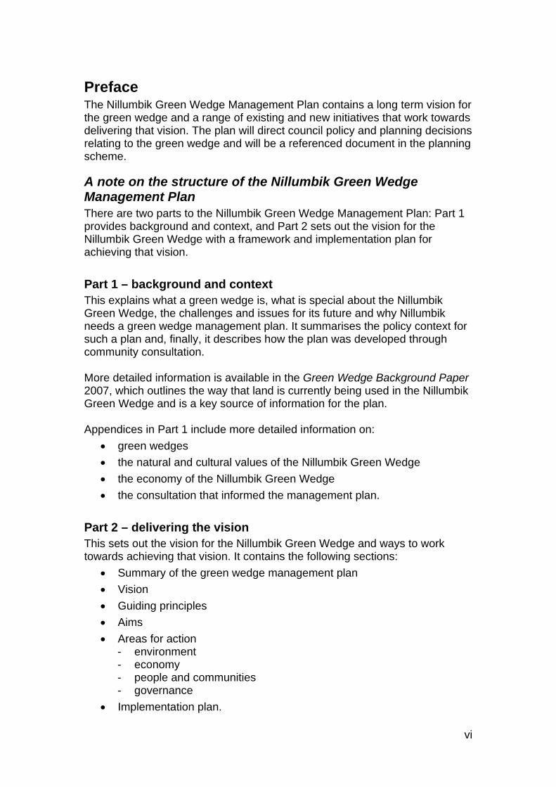
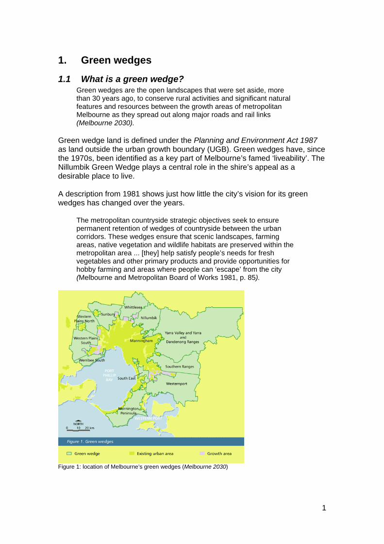
1.1 What is a green wedge? Green wedges are the open landscapes that were set aside, more than 30 years ago, to conserve rural activities and significant natural features and resources between the growth areas of metropolitan Melbourne as they spread out along major roads and rail links (Melbourne 2030).
Green wedge land is defined under the Planning and Environment Act 1987 as land outside the urban growth boundary (UGB). Green wedges have, since the 1970s, been identified as a key part of Melbourne’s famed ‘liveability’. The Nillumbik Green Wedge plays a central role in the shire’s appeal as a desirable place to live. A description from 1981 shows just how little the city’s vision for its green wedges has changed over the years.
The metropolitan countryside strategic objectives seek to ensure permanent retention of wedges of countryside between the urban corridors. These wedges ensure that scenic landscapes, farming areas, native vegetation and wildlife habitats are preserved within the metropolitan area ... [they] help satisfy people’s needs for fresh vegetables and other primary products and provide opportunities for hobby farming and areas where people can ‘escape’ from the city (Melbourne and Metropolitan Board of Works 1981, p. 85).
Figure 1: location of Melbourne’s green wedges (Melbourne 2030)
1
1.2. Why green wedges are important The Planning and Environment (Metropolitan Green Wedge Protection) Act 2003 provides protection for metropolitan green wedge land by establishing additional procedures for planning scheme amendments affecting that land. 1 The following broad purposes apply to all green wedges.
Economic
Provide opportunities for special uses including airfields, sewerage works and other infrastructure that supports urban areas.
Safeguard the opportunity for productive agricultural uses.
Provide for tourism and other businesses based on the natural and cultural heritage of the region.
Protect and conserve the opportunity to use non-renewable resources such as sand and stone.
Encourage the development of a more compact city.
Social
Preserve the enriching and cultural significance of open rural and scenic landscapes, green spaces and non-urban land.
Provide recreation development opportunities.
Provide a physically separate identity for towns and communities near the metropolitan boundary.
Environmental
Protect natural areas that contribute to biodiversity and the environmental health of the city.
Provide opportunities for developing a network of parks and open spaces based on the natural and cultural heritage of the region.
For a more detailed overview of green wedges and their history please see Appendix 1 and the Melbourne 2030 website at: <http://www.dse.vic.gov.au/melbourne2030online/content/implementation_plans/06_green.html>.
1
Authorisation from the Minister for Planning is required to prepare an amendment to a metropolitan fringe planning scheme that would amend or insert a UGB or amend or insert a provision that relates to or affects green wedge land.
Ratification by Parliament is required for any amendment to a metropolitan fringe planning scheme that has been approved by the minister that: (1) amends or inserts an urban growth boundary; or (2) has the effect of altering or removing any controls over the subdivision of any green wedge land to allow the land to be subdivided into more lots or into smaller lots than allowed for in the planning scheme (DSE 2003, p. 1).
2
2. The Nillumbik Green Wedge The Shire of Nillumbik was formed in 1994 with conservation of the green wedge as its strategic focus. The Nillumbik Green Wedge is distinguished from others by the quality of its environment and natural bushland. Above all it is the environmental qualities – the topography, the dense bushland and isolated spaces, the rivers and streams – and the diverse townships that create a sense of place and continue to draw people to settle in Nillumbik.
Melbourne 2030 identifies the Nillumbik Green Wedge as being of social, economic and environmental value because of the following features:
environmental and landscape quality (particularly the Yarra River and surrounds)
river red gums and other habitat areas
national parks
metropolitan water storages.
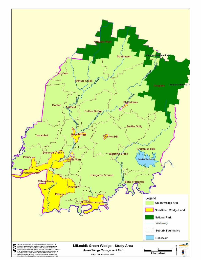
2.1 Location of the Nillumbik Green Wedge The Shire of Nillumbik is on Melbourne’s north-east fringe, 25 km from the city’s central business district. The Nillumbik Green Wedge covers 91 per cent of the total shire area. While the whole of Nillumbik is referred to as the ‘Green Wedge Shire’, in land use planning terms, green wedge land is defined as being outside the urban growth boundary. The Nillumbik Green Wedge is zoned Rural and is a mixture of Rural Residential (including some land zoned Low Density Residential) and hobby farms (together making up 47 per cent of the green wedge); vacant land (6 per cent); agriculture (20 per cent); conservation areas (20 per cent) and recreation land within the conservation areas (6 per cent). Seventy-nine per cent of Nillumbik Green Wedge land is in private ownership and around 43 per cent of that land has environmental significance (Nillumbik Shire Council 2006).
3
2.2 The natural environment The information in this section is a summary2, more detailed information can be found in Appendix 2 – natural and cultural values of the Nillumbik Green Wedge.
Geography and geology Framed by the Great Dividing Range to the north and by the Yarra River on the south, early European settlers called the central part of the region ‘The Plenty Hills’. The geographic essence of Nillumbik Green Wedge country is characterised by steep ridges and gently sloping hills enclosing plains and flats. The south is dominated by lowland hills and alluvial plains with ridgelines less than 200 metres in height. Further north, the country is steeper and comprises upland hills with ridgelines of over 200 metres. The shire's northern boundary is framed by the mountains of the Kinglake Ranges with elevations typically over 400 metres. The Aboriginal (Wurundjeri) name of ‘Nillumbik’ means ‘shallow earth’. Remnants of open grassy woodland, with relatively shallow soils dominated by long-leafed and red box eucalypts and occasional stands of ironbark, still remain on the hillsides, ridge tops and along the creeks. In fact wherever the land has not been cleared there are reminders of the original landscape and its origins, which distinguish this very special area. Both the landforms and the soils had their origin in sediments deposited in shallow seas during the Silurian period over 400 million years ago. Successive uplift, folding and erosion have not greatly altered the Silurian legacy of mudstones, siltstones and sandstones which are the basis of the generally clayey and silty soils. The fertile soils of an old volcano at Kangaroo Ground provide a stark contrast and farming and clearing there was widespread. The landscape is still evolving but it is the combination of natural and manmade elements which have given its scenery a distinctive character.
High conservation value Much of the shire’s native vegetation was cleared by European settlers for agriculture, particularly around Kangaroo Ground, Arthurs Creek and Doreen. However, Nillumbik retains large areas of native vegetation on both public and private land, particularly in the north and east of the shire. A comprehensive study of the biodiversity of Melbourne’s north-east, the NEROC report (Beardsell 1997), was conducted between 1986 and 1993. It identified 104 important sites across north-east Melbourne and, of these, 65
2 Historical information is from Butler,G. & associates 1996, Nillumbik Shire Heritage Study Environmental History and Aboriginal heritage studies completed between 1989 and 2006. Geological information is from Nillumbik Shire Council Land Capability Study 1998 and biodiversity (flora and fauna) data is based on a comprehensive and well regarded 1997 study: the NEROC report (Beardsell 1997).
5
are in the Shire of Nillumbik. NEROC identified 15 biodiversity ‘hotspots’ in the Nillumbik Green Wedge, seven of these are classified as 3ecological reference areas and the remaining eight as 4critical conservation areas. The report also identified three sites of national significance for their fauna: Yarrambat Morang wetland, Plenty-Janefield, Diamond Creek headwaters. The Department of Sustainability and Environment lists 72 biosites in the Nillumbik Green Wedge. Ten are of state significance and 29 of regional significance. Areas of intact native flora provide a high level of significant habitat and support a wide range of native animals. Extensive areas of the Nillumbik Green Wedge are of habitat or faunal importance and 61 per cent of the Nillumbik Green Wedge is covered by the Environmental Significance Overlay to protect these values. The Nillumbik Green Wedge is host to a number of state and national parks and Nillumbik Shire Council also manages a number of important environmental reserves.
Waterways and water catchment The Nillumbik Green Wedge is in the catchment of the Yarra River and is bordered by the Plenty River in the west and the Yarra River in the south and south-east. Three major creeks run through the Nillumbik Green Wedge: Diamond Creek, Watsons Creek and Arthurs Creek. The Nillumbik Green Wedge contains significant natural wetlands such as those along the Yarra River in the south-east and Running Creek Reservoir to the north of Arthurs Creek. Apart from natural waterways, the Nillumbik Green Wedge is the location for key parts of Melbourne’s infrastructure for potable water storage.
Bushfire Serious bushfire is a threat in the Shire of Nillumbik because of the vegetation cover, orientation of steep, sloping land and prevailing wind. In February 2009 Strathewen, St Andrews and Christmas Hills were severely affected by bushfire with significant loss of life and property. Major bushfires also affected parts of the shire in 1939, 1962, 1969, 1981 and 1991. In 2006 bushfires in Kinglake National Park threatened towns to the South of the Kinglake Ranges and were brought under control only after it rained. (Johns, D 2006).
3 Ecological reference areas are habitat and are defined as: ‘Tracts of viable, relatively undisturbed public land representative of land types that elsewhere have been subjected to extensive modification and use by Europeans’ (Land Conservation Council of Victoria, 1977 cited in Beardsell 1997, p. 67). 4 Critical Conservation Areas are on private land and contain ‘the most viable population for long term survival…of a designated threatened species… habitat…’ (Beardsell 1997, p. 66, 69).
6
2.3 People and cultural heritage This section outlines human influences on the landscape, the physical evidence left behind and the traditions that endure. More information can be found in the cultural heritage section of Appendix 2. When the first European settlers arrived in this area the most attractive features to their eyes were its proximity to Melbourne, the ease with which the land could be cleared for activities such as dairy farming and orchards and the discovery of gold at a number of sites. Over time, improved transport led to the development of more productive agricultural areas further away from Melbourne and Nillumbik found new business opportunities such as grape growing and providing for visitors.
Aboriginal owners The area called the Shire of Nillumbik is the traditional land of the Wurundjeri-willam clan of the Woiwurrung speaking people. A number of archaeological sites attest to Aboriginal presence within the shire including scarred trees and artefact scatters. Nillumbik Shire Council acknowledges the Wurundjeri as the traditional custodians of the land now known as the Shire of Nillumbik and values the Wurundjeri people’s history as essential to the unique character of the shire.
Pastoral leases and gold mining The transformation of the Nillumbik landscape began in the 1830s when the first European settlers arrived to take up pastoral leases across much of the shire. Other early settlers included timber cutters, who felled the stringybark forests for use in rapidly developing Melbourne; gold miners; itinerant workers; farm labourers and tenant farmers. Gold was discovered at Andersons Creek, Warrandyte in 1851, the first official goldfield in Victoria. The gold rush led to the establishment of townships at Panton Hill, Research, Queenstown (now St Andrews) and Diamond Creek.
Orcharding The development of a fruit industry in the northern areas of the shire and the arrival of the railway to Eltham and Hurstbridge helped sustain the towns and localities born during the gold rush era. By 1900, abundant orchards covered the west of the shire from Diamond Creek to Strathewen. Lemons, apples, plums, pears, peaches, grapes, oranges, persimmons, and more, were exported to other states and overseas. After Federation in 1901, World War I (1914–18) and the Great Depression (1929–32) many of the area's orchardists turned to other pursuits such as
7
poultry, selling firewood or supplementing their incomes by working for other landowners. Land was also more profitable for building and was sub-divided. Today, a small number of farms produce crops of apples, pears and grapes (Nillumbik Shire Council 2006, p. 22).
Wine growing Wine growing started in the Yarra Valley in 1836 at Yering. Today, the Shire of Nillumbik has a number of vineyards in the north-west corner of the Yarra Valley wine region.
Water supply Increasing population, following the gold rushes, created need for a permanent water supply. In the 1870s Yan Yean Reservoir's catchment area was extended and in 1886 work began on a weir on the Watts River near Healesville and on construction of the Maroondah Aqueduct to carry this water 66 kilometres into Melbourne. Creation of the Maroondah Aqueduct had a marked impact on the shire as many of the construction workers’ families settled along its route. Running Creek Reservoir, Hurstbridge, was completed in 1964 and Sugarloaf Reservoir was constructed during the 1970s. It was opened officially in 1980 and serves as a water storage and treatment plant supplying Melbourne.
Transport and tourism Many of the roads in the shire today are along routes set out by the early settlers. These include tracks laid out by miners and local suppliers of food to the diggings. The railway line to Eltham was opened officially in 1902 and was extended through Diamond Creek to Hurstbridge in 1912. It was electrified in 1926. Today, cars are the main form of transport within and to and from the Shire of Nillumbik. The shire's residents have the highest number of cars per household in Melbourne (Essential Economics 2008, p, 50). In the early 20th century easy access by rail was a boost for tourism, as day trippers flocked to enjoy the fresh air and rural aspects of the shire. There were a number of guest houses in Christmas Hills from the 1890sfor those wishing to stay more than a day (Butler 1996, p.48). Today, tourism is centred on boutique wineries, cafes and restaurants, art galleries and studios, bike riding, bed and breakfasts and on the area’s arts heritage. Scenic open spaces continue to be a drawcard as do attractions such as St Andrews Market and the Hurstbridge Farmers Market, which started in 2009.
8
A tradition of artists and ‘environmental’ building Ever since Walter Withers (1854–1914), a member of the 5Heidelberg School, lived in Eltham, the community has been home and inspiration for a number of Australia's artists and intellectuals. Montsalvat artists’ colony is the best known landmark of the area's artistic tradition. Clifton Pugh also established Dunmoochin, an artists’ colony, in the late 1950s at Cottles Bridge. Dunmoochin colony is an eclectic collection of mud brick homes, studios and cottages and still serves as an artist's retreat today. Alistair Knox, who designed and built many Eltham houses in his mud brick style, was a regular visitor to Montsalvat. He acknowledged its influence on his environmental building philosophy. Mud brick became the typical Eltham building style in the post-World War II period. In the 1970s local artist and environmental activist Neil Douglas established an Environmental Living Zone at Bend of Islands. He urged people to conserve their land as bush and to minimise their impacts on it. Such artists' colonies, the environmental and intellectual traditions and the diverse range of festivals, craft markets, galleries and exhibitions, all add to the shire's reputation as a centre for creative pursuits.
5 The Heidelberg School was an art movement in the late 19th century.
9
3. Green wedge management plans and their purpose
In October 2002 the Victorian Government introduced its 30-year planning framework Melbourne 2030 Planning for Sustainable Growth, which recognises the importance of Melbourne’s green wedges and protects them through the introduction of the metropolitan urban growth boundary. The Melbourne 2030 vision for green wedges is: ‘…to encourage their proper management and to protect them for non-urban uses’ (DSE 2005). The long term planning and management of Melbourne’s green wedges is a priority for the Victorian State Government. The city’s 17 green wedge councils are each required by Melbourne 2030 to produce a green wedge management plan for green wedge land in their municipality. A green wedge management plan (GWMP) is a council adopted strategy that identifies a vision, objectives and actions for the sustainable management of a particular green wedge. Nillumbik Shire Council’s GWMP is integral to the Nillumbik Planning Scheme. It informs, and provides guidance to, a range of other plans and strategies including the Municipal Strategic Statement. The plan identifies the values and features of the green wedge, the preferred land use, the environmental and natural resources to be protected and the social and economic needs of local communities and townships within the green wedge. It must be consistent with Melbourne 2030 and is not intended to re-open debates regarding Melbourne 2030 (DSE 2005, pp. 1, 5). Nillumbik’s GWMP includes the townships. These are not, technically, Green Wedge zoned land, but they are a part of its landscape: the future of the Nillumbik Green Wedge is linked to its townships. The Nillumbik Green Wedge will experience land use change over time. The GWMP is Nillumbik Shire Council’s opportunity to articulate, clearly, the kinds of development or activities – type, scale and form – likely to be supported in the Nillumbik Green Wedge and how this will be managed. The GWMP will provide greater clarity for all stakeholders, including landowners. Nillumbik’s GWMP includes a range of measures, such as changes to local planning policy, land use frameworks, education programmes and incentives. In delivering this GWMP it is important that the Shire of Nillumbik uses existing forums such as the interface councils and that it works in partnership and cooperation with adjoining municipalities, and with state government agencies. These agencies include Parks Victoria, Melbourne Water and the Port Philip Catchment Management Authority.
10
4. Policy context The Nillumbik Green Wedge Management Plan is not a stand-alone plan. It has been developed and will be delivered, within existing state and local planning frameworks and policies. Its preparation is guided by the Department of Sustainability and Environment practice note: Preparing a Green Wedge Management Plan, August 2005. The concept of green wedges as rural landscapes and natural areas separating corridors of urban development is a longstanding metropolitan planning commitment. This commitment has been endorsed and promoted by the Victorian State Government policy document Melbourne 2030 and, subsequently, by Melbourne @ 5million which confirms these policy directions. In this context the Nillumbik Green Wedge is a resource to be protected and managed on behalf of the whole metropolitan community because of its environment and its recreational, agricultural, economic and social values. The following policies, plans and strategies affect management of the Nillumbik Green Wedge:
state government policies
Nillumbik Shire Council policies and planning controls
related state government and council strategies.
11
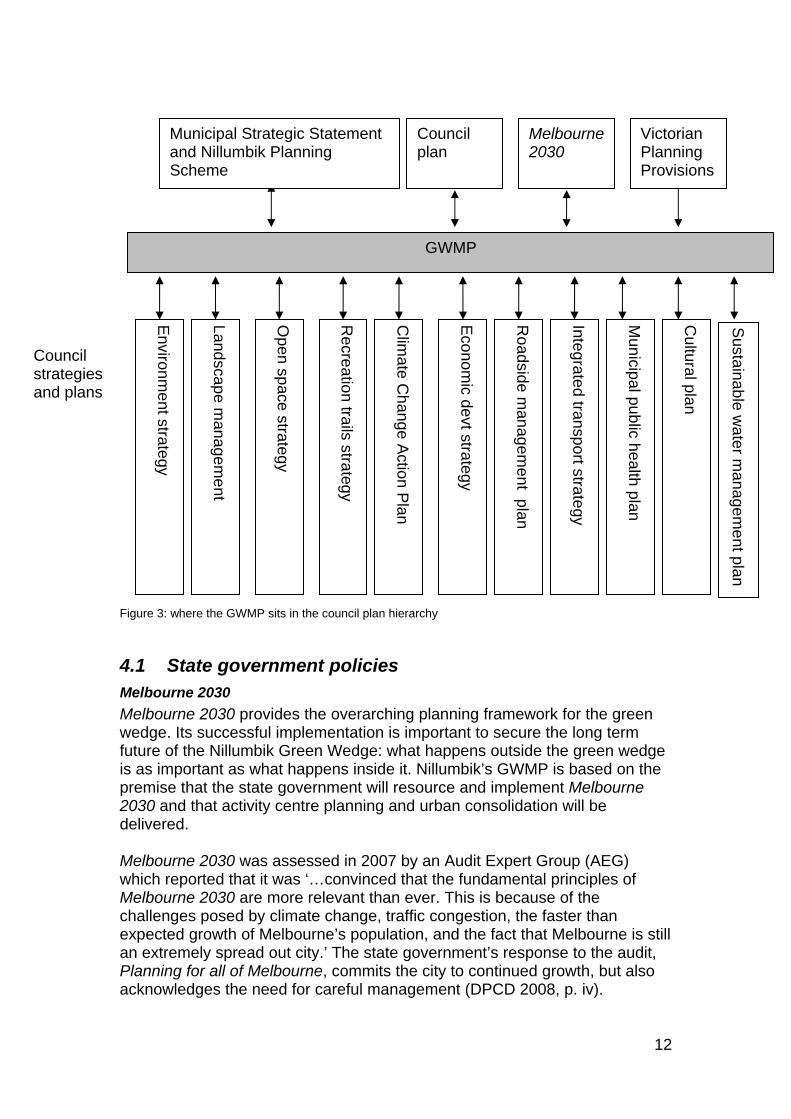
Figure 3: where the GWMP sits in the council plan hierarchy
4.1 State government policies Melbourne 2030
Melbourne 2030 provides the overarching planning framework for the green wedge. Its successful implementation is important to secure the long term future of the Nillumbik Green Wedge: what happens outside the green wedge is as important as what happens inside it. Nillumbik’s GWMP is based on the premise that the state government will resource and implement Melbourne 2030 and that activity centre planning and urban consolidation will be delivered. Melbourne 2030 was assessed in 2007 by an Audit Expert Group (AEG) which reported that it was ‘…convinced that the fundamental principles of Melbourne 2030 are more relevant than ever. This is because of the challenges posed by climate change, traffic congestion, the faster than expected growth of Melbourne’s population, and the fact that Melbourne is still an extremely spread out city.’ The state government’s response to the audit, Planning for all of Melbourne, commits the city to continued growth, but also acknowledges the need for careful management (DPCD 2008, p. iv).
Environm
ent strategy
GWMP
Landscape
managem
ent
Open space strategy
Recreation trails strategy
Clim
ate Ch
ange Actio
n Plan
Econom
ic devt strategy
Roadside m
anagement plan
Integrated transport strategy
Municipal public health plan
Cultural pla
n
Council plan
Melbourne2030
Municipal Strategic Statement and Nillumbik Planning Scheme
Victorian Planning Provisions
Sustainable w
ater managem
ent plan
Council strategies and plans
12
Of particular note for the Nillumbik GWMP is that the AEG made the following recommendation (AEG recommendation 5.2) in respect of green wedges:
…the state government gives higher priority to enhancing the contribution of green wedges to the sustainability and liveability of Melbourne. Means by which this can be achieved include:
implementing the green wedge management plans, ensure that controls on the land recognise the inherent differences in the nature and capability of land within each green wedge
developing appropriate incentives and programs for assistance to landowners to manage and maintain this important metropolitan resource
ensuring that tourist and recreational developments in green wedges are only approved where they support Melbourne 2030 (DPCD 2008, p. 47).
Melbourne @ 5 million
In December 2008 the state government released an update to Melbourne 2030: Melbourne @ 5 Million. Melbourne @ 5 million provides policy initiatives that are complementary to the directions of Melbourne 2030 and commits to protecting Melbourne’s green wedges by concentrating future urban growth into clearly defined growth corridors. The two documents should be considered together. Melbourne @ 5million contains proposals to expand the urban growth boundary to allow for expansion of the growth areas. Areas to be considered for inclusion within the growth areas are designated investigation areas. Amendment VC68, passed by the Victorian Parliament in August 2010, changes the alignment of the UGB in the Casey, Hume, Melton, Whittlesea and Wyndham planning schemes and extends it to include part of the Mitchell planning scheme to increase the area of urban land in Melbourne. Nillumbik is not in a designated growth/investigation area and, as such, no changes to the urban growth boundary in the Nillumbik area are proposed.
Other state and regional policies
There is a multitude of plans, programmes and other initiatives which have an impact on the Nillumbik Green Wedge and which cover areas such as tourism, agriculture, conservation, planning, and roads. The following are of particular note:
Melbourne 2030 - Implementation Plan 5: Green Wedges (2002)
Principles Issues and Guidelines for Green Wedge Management Plans (DSE 2005)
Preparing a Green Wedge Management Plan (Practice Note, DSE 2005).
13
In addition, there is regional or state level guidance available on related issues such as catchment management and biodiversity including:
Linking People and Spaces (Parks Victoria)
Northern Regional Housing Statement
Regional Catchment Management Strategy.
4.2 Nillumbik Shire Council policies Council Plan 2009–2013
Council’s Plan 2009–2013 recognises council’s responsibility for managing and protecting the green wedge (action 2.1.5). It also recognises the importance of the local economy and supports '… appropriate economic development in the green wedge including tourism, food production and agriculture…'.Council is committed to the placement of the urban growth boundary in accordance with state government policy.
4.3 Nillumbik Planning Scheme Nillumbik is called the Green Wedge Shire and this reflects the fact that 91 per cent of the shire is outside the urban growth boundary and recognises the strong conservation focus of its residents. The main council planning document applying to the Nillumbik Green Wedge is the Nillumbik Planning Scheme which incorporates the Municipal Strategic Statement (MSS). The MSS sets out the broad strategy for the Nillumbik Green Wedge and Nillumbik as a whole. The Nillumbik Municipal Strategic Statement states that:
… in defining the boundaries of the shire, the Local Government Board recognised the strong rural and conservation focus shared by the communities of interest in this particular region of Melbourne.
In keeping with this statement the Nillumbik Planning Scheme states that the shire has a role as a metropolitan cultural, nature conservation and recreation resource that will continue to be recognised throughout the state.
All future land use and development will enhance the aesthetic qualities of the urban and rural environment responding in particular to the character defined by land form, landscapes and vegetation cover. The energies of the Nillumbik Shire Council will be directed to enhancing the environmental conditions that enrich the area and promoting development which meets present needs without compromising the future wellbeing of the shire. In this way, the Shire of Nillumbik will achieve an environmentally, socially and economically sustainable future.
14
More detailed statutory controls are set out in the remainder of the planning scheme where provisions for the various Green Wedge Zones and overlays are described. Details of these can be found in the Nillumbik Planning Scheme.
Current planning controls The objective of planning controls is to protect the rural character and values of the Nillumbik Green Wedge and to prevent urban encroachment. In May 2004 the state government introduced into the Nillumbik Planning Scheme Clause 57 Metropolitan Green Wedge Land and the new Green Wedge Zones. This resulted in the Environmental Rural Zone and Rural zones being replaced by the Rural Conservation and Green Wedge Zones respectively. The introduction of the new zones, in particular the Rural Conservation Zone, which covers most of the non-urban part of the municipality, has tightened the planning controls; placing restrictions on uses including accommodation, industry, agriculture, retail, leisure and recreation. The changes are highly relevant to the future economic direction of the Nillumbik Green Wedge and will influence the type of development that can occur, especially tourism and related activities. The following planning controls are applied in the Nillumbik Green Wedge:
Green Wedge Zone (Clause 35.04)
Rural Conservation Zone (Clause 35.06)
Public Conservation and Resource Zone (Clause 36.03)
Public Use Zone (Clause 36.01)
Special Use Zone (Clause 37.01)
Environmental Significance Overlay (Clause 42.01) Schedules 1, 2, 3, 4
Siting and Design Policy for Buildings and Works in Rural Areas (Clause 22.04).
Development of Small Lots in Green Wedge Areas (Clause 22.03 – expired in 2009)
Subdivision Policy (Clause 22.02 – expired in 2009)
Wildfire Management Overlay (Clause 44.06)
Wildfire Management Policy (Clause 22.13). The Rural Conservation Zone is the predominant zone within the Nillumbik Green Wedge. This zone and the Green Wedge Zone, apply to private land within the Nillumbik Green Wedge. They are collectively referred to as the Green Wedge Zones.
15
4.4 Nillumbik Shire Council strategies Economic Development Strategy (2003)
The Economic Development Strategy provides guidance to council in setting its priorities for economic development in the shire. It is being updated in 2010.
Environment Strategy (2001)
The Nillumbik Environment Strategy describes council's vision and goals for the environment and as such, it provides a strategic framework for many of the environmental initiatives which impact on the green wedge. The Environment Strategy (2001) commits to the protection of the Nillumbik Green Wedge and associated biodiversity and landscape values. The strategy is being reviewed in 2010. The Climate Change Action Plan (2008–2015) and the Sustainable Water Management Plan (2008) replace the environment strategy on an interim basis. The GWMP is informed by, and informs, the Climate Change Action Plan and the Sustainable Water Management Plan in terms of priorities and actions. It will build on the recommendations of both strategies and, if appropriate, suggest modifications.
Climate Change Action Plan 2008–2015 (2008)
Climate change and conservation of resources is an area where the Nillumbik community wants to see action. This plan tackles the issues associated with greenhouse gas emission through our everyday council operations as well as ways in which to support the community to reduce reliance on greenhouse gases. As such this plan is a key delivery mechanism for the GWMP.
Sustainable Water Management Plan
The Nillumbik Sustainable Water Management Plan (SWMP) aims to provide strategic direction for improved water management throughout the Nillumbik community and council, and forms a key component of the ICLEI Water Campaign™ (International Council for Local Environmental Initiatives). The Sustainable Water Management Plan provides council and the community with a structure for building upon experiences to date and for achieving greater reductions in reticulated water usage.
Open Space Strategy (2005)
This strategy defines council’s vision and strategic directions for open space in the Shire of Nillumbik with emphasis on passive recreation and conservation. It aims to coordinate actions arising from state, regional and local policies that impact on Nillumbik’s open space. It covers both urban and rural areas of the shire and centres on three types of open space: reserves (land accessible to the public for recreation), nodes (popular destinations e.g. miniature railway at Eltham Lower Park) and trails (linking together the reserves and the nodes). The open space network is largely in place and this strategy looks at how it can be enhanced and, in some cases, extended. The strategy is based on five guiding principles one of which is ‘sustainability’ and commits to protecting
16
areas of environmental value including remnant vegetation, habitat, waterways, cultural heritage and areas of ‘landscape significance’ (p. iii). In the rural areas the emphasis is on ‘…enhancing and developing open space within townships and settlements, protecting native flora and fauna…’ Specific actions for rural open space are detailed on pages 4–9 of the strategy. Cultural heritage is recognised as a forming influence on the Nillumbik landscape and the strategy highlights both Aboriginal and European heritage and the desire to protect and interpret sites (pp. 26–27). The actions of this strategy contribute to delivery of the GWMP in promoting access to, and understanding of, Nillumbik’s environment.
Roadside Management Strategy (1997)
The aim of this strategy is to maintain and enhance the environmental, historical and landscape values of Nillumbik’s roadsides as well as providing service corridors for utilities such as sewerage and electricity. This strategy will be reviewed in 2010 following the February 2009 bushfires.
Recreation Trails Strategy (2007)
This strategy focuses on the provision and development of recreation trails in the Shire of Nillumbik, including green wedge areas. Its focus is on delivering council’s commitment to enhancing the wellbeing of communities through providing access to physical activity. The strategy is under review in 2010 and the strategies and consultation inputs from the GWMP will be considered by the consultant undertaking the review. The Recreation Trails Strategy is important for delivering social, environmental and economic objectives of the GWMP.
17
5. Challenges and issues This section of the GWMP summarises key challenges for the Nillumbik Green Wedge and their likely impact.
Identifying the challenges These issues were identified through research for the Green Wedge Background and Issues Paper (Nillumbik Shire Council 2006), consultation and economics research carried out by council in 2008. Strategies and actions for addressing the challenges are in Part 2 of this document. The Nillumbik Green Wedge faces many challenges. These range from the local impacts of global concerns such as climate change and peak oil, to locally expressed concerns about rural versus urban living; population decline; environmental and agricultural viability; the economic role of traditional agriculture and the opportunities and challenges presented by tourism. We need to acknowledge these challenges, recognise opportunities they might present and understand where council and the community can have an influence (and where they cannot.) We need to manage change in a positive and proactive way, to think globally and act locally. Former Victorian Commissioner for Sustainability, Ian McPhail, believes local governments can make a difference:
This level of government [local] has a very immediate role in shaping the local environment through urban planning, open space design and maintenance, and waste management (2008, p. 45).
Taking the challenges and local issues and combining them with what the community values about the Nillumbik Green Wedge produces a series of areas on which the GWMP concentrates its focus. These are as follows.
5.1 Climate change and greenhouse gas emissions Victoria has an ecological footprint three times the world average: ‘If everyone lived like Victorians, almost four planets would be needed…Victorians’ way of life is not sustainable’ (Commissioner Environment and Sustainability 2008, p. 4). Scientific evidence from the Intergovernmental Panel on Climate Change (IPCC), the Hadley Centre for Climate Change and Research and the UK’s Stern Review indicates that global temperatures are rising as a result of human-induced greenhouse gas emissions adding to the levels of carbon dioxide in the earth’s atmosphere. It is crucial to remove excess greenhouse gas from the atmosphere over the next 10 years (Nillumbik Shire Council 2008, p, 8).
18
In the Nillumbik Green Wedge, climate change is having an impact on land-use, water, agriculture and horticulture, on the environment as a whole and on the quality of life and wellbeing of residents. Council and the Nillumbik community have an opportunity to adopt best practice on a local basis to address it. Council’s Climate Action Plan (2008) identifies the following impacts on the Shire of Nillumbik and its green wedge: reduced rainfall and drought conditions, increased temperature extremes and more extreme weather events (Nillumbik Shire Council 2008 pp. 7–9). These climatic changes will result in a range of local impacts including increased fire risk; the loss of gardens; deterioration of parks and sporting ovals; higher food prices; damage to property (e.g. to foundations); decrease in run-off and stream flow; impacts on agricultural production; more vulnerability to weed and pest invasion; loss of plant and animal species; higher energy costs; risks of energy blackouts; heat stress particularly in the elderly and vulnerable; increased risk of harm to people and property; increased risk of water catchment damage. Management of fire risk in the Nillumbik Green Wedge is a significant issue. The combination of extensive vegetation cover, the orientation of steep sloping land and prevailing winds make serious bushfire a primary threat in the green wedge (Nillumbik Shire Council 2006, p. 45). The recommendations of the Royal Commission into the February 2009 bushfires are important. The management of weeds and other pests is a major issue. Managing the environment is the responsibility of all landowners and not just council and public agencies. The effectiveness of programmes and initiatives for environmental management must be assessed. The rate relief for farmers and grant programs are considered by recipients to be nominal and have little effect on land management practices. In summary, climate change will have, and is having, varied impacts on the Nillumbik Green Wedge which need to be addressed as a priority. All people in the Nillumbik Green Wedge need to recognise the impacts of climate change in the way they live and the choices they make.
5.2 Population change and housing and services According to estimates based on the Australian Bureau of Statistics (ABS) 2006 Census data, the population of the Nillumbik Green Wedge is approximately 17 750 with 10 450 people in the rural areas and 7300 in the towns. Currently, the Nillumbik Green Wedge has a slightly older age profile than the Shire of Nillumbik as a whole, but younger than metropolitan Melbourne. Projections show a significant ageing of the population to the year 2031 when it is estimated that 21 per cent of Nillumbik residents will be over 65 years old in contrast to the current figure of nine per cent (Essential Economics 2008, pp. iv, 16– 17). This has particular implications for provision of housing, and demand for services such as health care.
19
In addition to ageing, the Nillumbik Green Wedge population is also expected to decline over the next 25 years, with most decline in the townships (from 7300 to 6180 by 2031). This has social and economic implications, notably for retaining local services such as schools, sports grounds and clubs, stores, pubs and local employment. Conversely, the number of households is expected to grow from 5510 in 2006 to 5825 in 2016 and 6160 in 2031 following the wider trend for smaller households. (Essential Economics 2008, p. iv). While the population in the Nillumbik Green Wedge is expected to decline, the population of Melbourne and, particularly Whittlesea on the Shire’s western boundary, will increase. In Whittlesea, the population is expected to nearly double in the next 20 years from 132 155 to 220 000 by 2030 as the city becomes Victoria’s fastest growing municipality (Whittlesea City Council, 2008). Of the one million people projected to settle in Melbourne over the next 30 years 8.78 per cent will be in Whittlesea. More people produce more demand for services, recreation opportunities, water and transport and will mean higher car use and consequent pollution. This increase in Melbourne’s population could be seen as a threat to the integrity of the Nillumbik Green Wedge environment and sense of place but it could also be an opportunity. For example, it could mean more custom for local businesses, including tourism destinations, and advocates for the value of the Nillumbik Green Wedge. Incremental development through an expansion in rural residential living represents a potential threat to environmental and agricultural values and to the visual landscape. In particular, there is concern about the remaining undeveloped lots in the Nillumbik Green Wedge which are already below the minimum sub-division and could, potentially, have houses on them. Concerns relate to whether this type of development reduces agricultural viability where land is cleared and environmental values where it is not. There is a perceived lack of understanding by some new (previously urban) residents and visitors about the responsibility and reality of living in the Nillumbik Green Wedge. In summary, the demographic composition of the Shire of Nillumbik is changing and council has to plan for this inevitability. There are concerns that lower socioeconomic groups will be priced out of the Nillumbik Green Wedge property market and that climate change will adversely affect residents’ quality of life.
20
5.3 Peak oil – the end of plentiful cheap energy Ian Lowe, Emeritus Professor of Science, Technology and Society at Queensland’s Griffith University, notes that the two big challenges for future energy are ‘peak oil’6 and climate change: ‘Economic development in the 20th century was fuelled by plentiful cheap energy. It has been clear for decades that the energy outlook for this century is totally different … there is no escaping the conclusion that the age of plentiful cheap petroleum fuels is ending’ (Lowe 2008, p. 201, 202, 204). The relative lack of public transport, population spread and high proportion of workers travelling outside the municipality for work means Nillumbik’s Green Wedge residents have a high level of car dependence. More than 75 per cent of people commute to locations outside of the shire for work (Essential Economics 2008, p. 50). This is the highest rate of all the eight interface councils (Parliament of Victoria 2008, p. 314) and it raises social, economic and environmental issues. Of particular concern are: long hours away commuting for work, lack of local jobs particularly for young people, climate change and air pollution. Compact, urban activity centres providing essential goods and services, as envisaged by Melbourne 2030, are important for the future of the Nillumbik Green Wedge. A more optimistic view of the impending energy crisis is that there are alternative energy sources and that these will be harnessed in the future and, further, that climate change and peak oil are a positive opportunity to restructure our ways of living and to create sustainable towns7 and more local employment.
5.4 Economy Issues concerning the economy of the Nillumbik Green Wedge fall into the categories of funding, management, business opportunities and infrastructure. How can the management of the Nillumbik Green Wedge be funded? What types and level of business activity, including tourism, are in keeping with the Nillumbik Green Wedge so that they do not impact adversely on its values? How can business opportunities be expanded in townships (where there is a
6 Peak oil signifies the point in time when oil production is at its highest and, after that, it declines. The reason this is important is that following peak oil, worldwide supply will be unable to meet demand particularly since, as supply falls, demand is projected to increase. Scientific opinion indicates that peak oil has already been reached or will be reached within the next few years (Maribyrnong City Council <http://www.maribyrnong.vic.gov.au/Files/PeakOilPolicy.pdf>. 7 For example, the Transition Towns movement: <http://www.transitiontowns.org/>.
21
lack of commercial and industrial land and a perceived ‘anti-business’ attitude from council)? Finally how can council meet the high cost of maintaining infrastructure and waste disposal services in dispersed rural areas?
5.5 Environment There is widespread concern about the environment of the Nillumbik Green Wedge. These concerns are chiefly about management of land and environmental values, rural residential living, tourism and unsuitable development. Education is critical in managing the environmental impacts on the green wedge. In addition to the impacts of climate change, described in section 5.1 above, other issues are air and water pollution; the need to protect environmentally significant areas and the Nillumbik Green Wedge landscapes. There is also a perception that open landscapes are threatened by plantings like cypress hedges or windrows and concern that the impact of adjoining urban areas, particularly the Whittlesea growth corridor, will be detrimental to environmental values.
5.6 Governance – Nillumbik as part of a wider green wedge Sustainable green wedges are the responsibility of all levels of government and also non-government agencies, landholders and community. It is also important to closely coordinate the management of adjacent green wedges. One of the key recommendations from the Community Advisory Group was to consider the potential benefit in a whole-of-landscape approach to managing the green wedge. The key reason is that the landscape does not end artificially at council boundaries. Given that the GWMP commits to managing the environment at a landscape scale, there is merit in investigating alternative governance models. The model proposed by the Community Advisory Group would involve creating a larger green wedge, which might include Yarra Ranges, Whittlesea and Nillumbik Shire. A new model of governance, potentially an independent Green Wedge Management Authority, could manage it. This authority would have its role set out in legislation and would be responsible for:
conservation and enhancement of the green wedge landscape – which means looking after the landscape, heritage, flora and fauna
promoting people’s enjoyment of the landscape and providing opportunities for them to understand it
supporting the local economy to ensure a thriving local community. Areas of work for the management authority might be: conservation, land and water management, planning, recreation, visitor services and a key role in education. Its members would be drawn from councils and community. Under the proposed model, funding for the Green Wedge Management Authority and its programmes would be provided by state or federal government. Local services like rubbish collection would continue to be funded by the rate base within each of the three councils.
22
Recent boundary changes made by the state government and an electoral cycle that sees governments come and go contribute to a perception that the Nillumbik Green Wedge does not have long term security. In addition, funding to manage the Nillumbik Green Wedge is not recognised as a significant issue by state and federal governments. It is clear that additional funding sources are required and this is a key issue for council to pursue.
23
6. Development of the Nillumbik Green Wedge Management Plan
Nillumbik Shire Council’s GWMP is informed by a combination of existing and commissioned research and by consultation with communities. The GWMP was developed in four stages. Council provided multiple opportunities for people to provide input to the content of the plan and feedback on draft documents. A council-appointed Community Advisory Group, comprising representatives from a range of organisations, met at key stages in the process to provide input and guidance. A cross-council officer working group provided technical advice as required. A detailed account of the community consultation process is in Appendix 4.
Stage 1 – background research Technical studies
A number of technical studies inform the Nillumbik Green Wedge Management Plan.
Sites of Faunal and Habitat Significance (Beardsell 1997)
DSE Biosite mapping
Land Capability Study (Woodward-Clyde 1998)
Shire Commodity and Economic Profiles (Clark 2006)
Open Space Strategy (Nillumbik Shire Council 2005)
Roadside Management Plan ( Nillumbik Shire Council1997)
Recreational Trails Strategy (Nillumbik Shire Council 2001)
Nillumbik Green Wedge Management Plan – Economic Research (Essential Economics 2008)
Background and discussion papers
The comprehensive Green Wedge Background Paper (Nillumbik Shire Council 2006) documents existing information on the Nillumbik Green Wedge including studies on land capability, environmental values, and Aboriginal and European history. It includes sections on the history of the Nillumbik Green Wedge; policy context; land use; environment; people and community; infrastructure and services. The background report and technical studies provide an evidence base for developing the objectives and strategies of the GWMP and for identifying additional information needs. A Discussion paper was developed from the information in the Background Paper and issued for consultation in February 2007 (Nillumbik Shire Council 2007).
24
Stage 2 – values and vision The purpose of this stage was to understand what is special about the Nillumbik Green Wedge in terms of its environment, flora and fauna, cultural heritage and people. In this stage council consulted with communities to see what they value about the green wedge, and to identify the main issues that concern them. In this way council was able to develop an informed vision for the future of the Nillumbik Green Wedge. A range of consultation methods were used including workshops, an internet survey of council’s ‘talkback’ panel, meetings with key stakeholders and attendance at local fairs and markets. Feedback was drawn together into a consultation report and this was used to develop a paper – Visions values and guiding principles – that would guide the plan’s objectives, strategies and actions. The Values vision and guiding principles paper was issued for consultation in November 2007.
Stage 3 – options development The purpose of this stage was to draw together the differing viewpoints received through consultation to help move from an aspirational vision to something more tangible. A Scenarios paper setting out four possible futures for the Nillumbik Green Wedge was issued for consultation in March 2008. This paper acknowledged that the agreed way forward may be a combination of elements drawn from one or more of these possible futures.
Stage 4 – draft green wedge management plan The GWMP draws together data, issues, and community views from the three stages above and determines the direction council will take in managing the Nillumbik Green Wedge land. The draft GWMP was exhibited from 1 December 2009 to 1 March 2010.
25

Appendices
26
Appendix 1 – green wedges
Green wedge attributes
These features typify land in Melbourne’s green wedges.
Environment/conservation features
areas used and suited to parks and conservation (national, state and local)
areas of floral and faunal significance
areas with native vegetation cover
wetlands
rivers and streams and their environmental buffers
significant geographic features (ridge lines, river valleys, mountains, plains)
heritage areas (natural/Indigenous/European)
Natural resource features
areas with potential for extractive industries (stone, sand, clay, soil)
areas of productive agricultural land (existing or potential)
timber reserves
water-supply catchments
areas considered suited to waste-water reuse
Community value features
areas of recognised landscape value
areas used or suited for recreation – public and private
open landscapes separating and distinguishing different urban communities
Existing policy features
areas identified at state level as off-limits to urban development, for example, Mornington Peninsula, Yarra Valley, Dandenong Ranges, Macedon Ranges
land identified in local policy instruments as preferred non-urban areas
Physical/safety features
areas of flooding and drainage difficulty
areas of high fire hazard
steep land subject to erosion and/or subsidence
coastal land subject to erosion
land with effluent absorption constraints (septic systems)
areas of contaminated land
Trunk servicing features
areas remote from public transport corridors
areas with constraints in providing physical and social services
areas near high-voltage transmission lines and major gas pipelines
Major facility features
locations used for or suited to airports and airfields
27
locations used for sewage treatment
locations used for or suited to waste disposal and recycling
locations used for prisons and other institutional uses
Potential land use conflict features
buffer areas required around uses with off-site effects, for example, Environment Protection Authority buffers and airport buffers
Melbourne’s green wedge history Retention of … green areas in close proximity to urban development has been a feature of Melbourne since its inception…. Today, green wedges form part of a green belt, a vital component of a ‘most liveable city’. We must ensure adequate, unequivocal measures for their long term preservation as part of a viable strategy for Melbourne and its hinterland … Melbourne 2030 is an important step in that direction (Harris 2005, p. 71).
Protecting the green spaces around the fringe of Melbourne from encroaching urban development has been a hotly contested topic since the early 1900s. The basis of green wedge planning is traceable to the British planning model which influenced Australian town planning practices in the 1950s. The first description of a green wedge was published in a 1959 Melbourne Metropolitan Board of Works (MMBW) report: The problem of urban expansion in the Melbourne metropolitan area.
…controlled outward expansion [with] the development of compact communities possibly separated by substantial but limited areas of open space … [to] break up the urban mass and afford convenient opportunity for relaxation, recreation and enjoyment in a natural environment (ibid., p. 22).
In 1966 Richard Hamer, Minister for Local Government, introduced the idea of green wedges to protect non-urban areas and, in 1968, the state government formally adopted a green wedge strategy. The MMBW developed this further in its report Planning policies for the Melbourne metropolitan region which proposed designating permanent green wedges (Harris 2005, p. 37, 38). The Victorian Government’s Melbourne 2030: planning for sustainable development (2002) picks up this longstanding intention with the introduction of the metropolitan urban growth boundary (UGB). The UGB defines the boundary between urban and non-urban areas and prevents the unconstrained outward expansion of residential development. Under the Planning and Environment Act 1987 urban growth boundaries cannot be altered without positive ratification by both houses of Parliament. It is a step towards ensuring the future conservation of the green wedges, which have been a concern for community and government for more than 100 years. At the end of 2008, the Victorian Government indicated that it would, through Melbourne @ 5 Million, review the position of the metropolitan UGB in existing growth areas. It did this by passing Amendment VC68 through Parliament in 2010. There is no intention to review the UGB in other areas.
28
Appendix 2 – natural and cultural values of the Nillumbik Green Wedge There are many influences, both natural and cultural, that have shaped the Shire of Nillumbik, and its green wedge, over the centuries. This section outlines the natural and the cultural values of the Nillumbik Green Wedge including Aboriginal and European history and influences. In considering the current day challenges we must address, it helps to understand just how much has changed in the last 150 years. Historical information is drawn from council’s heritage study, Green Wedge Background report and reports on Aboriginal heritage in the Shire of Nillumbik:
Butler, G & Associates 1996, ‘Nillumbik Shire Heritage Study Stage 1, Vol. 2 Environmental History’, unpublished study
Ellender, I 1989, The Plenty Valley Corridor: The Archaeological Survey of Aboriginal Sites, unpublished survey
Ellender, I 1994, The Aboriginal Heritage of the Shire of Eltham, unpublished study
Du Cros & Associates 1996, Nillumbik Shire Council Aboriginal Heritage Study, unpublished study
Tardis Enterprises 2006, Nillumbik Shire Heritage Review, unpublished review.
Geological information is from Nillumbik Shire Council Land Capability Study, 1998. Biodiversity (flora and fauna) data is based on a comprehensive and well regarded 1997 study – the NEROC report (Beardsell 1997). This study illustrated the environmental significance of the Nillumbik environment. It will be reviewed in 2010/2011 as an action arising from the GWMP. Economic and population statistics were researched in 2008.
Natural values
Geology
The geology of the Nillumbik Green Wedge is mainly Devonian and Silurian sedimentary rocks. However, there are variations and in the south, near the Yarra and Plenty Rivers, there is siltstone, calcareous sand and dune limestone. The remaining areas, including the Kinglake Ranges, are siltstone, sandstone, slate and limestone. Geological folding has created a series of north-south ridges and valleys. One notable exception to the relatively uniform geology is a small volcanic plateau covering an area of 2.8 km2. At its centre (the eruption point) is one of the Nillumbik Green Wedge’s best known landmarks: the site of Kangaroo Ground War Memorial Tower and viewing platform at Kangaroo Ground. The land system here is Tertiary basalt overlying Silurian sediments.
Land systems
The Shire of Nillumbik is predominantly an undulating landscape. Lowland hills and alluvial plains with ridgelines less than 200 m in elevation dominate in the south. Further north, the country becomes steeper and comprises upland hills with ridgelines of over 200 m. Near the shire's northern boundary the more mountainous
29
terrain of the Kinglake Ranges of the Great Dividing Range has elevations typically over 400 m. The Nillumbik Land Capability Study was produced in 1998 and found that the majority of the shire has thin soils with poor structure and low inherent fertility. To offset this, the area has relatively high and reliable rainfall and a long growing season. The areas with gentle to moderate slopes (below 20%) are generally of average agricultural quality, but there are small areas of deeper, better structured soils. Most notably the 2.8 km2 of volcanic soils at Kangaroo Ground are of average to high agricultural quality. The capability study identified land systems, which are areas with similar rainfall, geology, topography and indigenous vegetation. There are five land systems present within the Nillumbik Green Wedge and a summary of these systems is provided below. Arthurs Creek land system This is the largest land system and it is fairly widely dispersed throughout the shire. It comprises low hills on sedimentary rock with duplex and gradational soils with slopes between 15% and 25% but up to 35%. Most of the area has been cleared and is used for grazing but it also contains areas of indigenous woodland or open forest. The land system has a high erosion hazard due to the hard-setting-surfaces which tend to increase run-off and dispersible clay soils. Land in the Arthurs Creek land system is defined as being Class 3 (average quality). Doreen land system This land system comprises low, primarily gently undulating hills in the west of the shire. The bedrock is sedimentary with duplex and gradational soils. Slopes are predominantly gentle to moderate (5 to 15%) but in places are up to 25% and most of the area has been cleared and is used for grazing. As the soils have dispersible clay sub-soils the erosion hazard is high. Land in the Doreen land system is defined as being Class 3 (average quality). Kangaroo Ground land system This small land system comprises 2.8 km2 of basalt capping at Kangaroo Ground. The topography is an undulating plain with slopes predominantly ranging from 5% to 10%. The soil comprises black clay of uniform texture and course structure and the area has been cleared of indigenous vegetation and has been used for agriculture. Erosion and foundation movement are hazards in this system due to expansive clay soils. Land in the Kangaroo Ground land system is defined as ranging from Class 2 (high agricultural quality) to Class 3 (average quality). Skyline Road land system Situated along the northern and eastern boundaries of the shire, this land system is characterised by long, high ridges and steep-to-very-steep slopes. The geology is sedimentary and soils are duplex or gradational; slopes are predominantly greater than 35%. Due to its steepness, most of the area is still covered with indigenous open forest. The steep slopes are highly susceptible to erosion and moderately susceptible to landslip following earthworks or clearing.
30
Land in the Skyline Road land system ranges from Class 3 (average quality) to Class 4 (poor). St Andrews land system This large land system is scattered throughout the shire but large concentrations occur at St Andrews, Christmas Hill and North Warrandyte/Research. It comprises steep hills on sedimentary rock with mostly shallow gradational and duplex soils. Slopes are predominantly greater than 35%, but there are small pockets with shallower slopes. Much of the area is still covered with indigenous woodland and erosion is an identified hazard. Land in the St Andrews land system ranges from Class 3 (average quality) to Class 5 (very poor). Distribution of land systems It is important to note that because of the extremely undulating nature of the Nillumbik landscape, it is common to find several land systems within a very small area. The land systems of Doreen, Kangaroo Ground and Skyline Road have easily defined boundaries. However the land systems of Arthurs Creek and St Andrews are less distinctly defined and are found throughout the central, eastern and southern areas of the shire. There are also a considerable number of variations in character within each land system.
Water
The Nillumbik Green Wedge is situated in the Yarra Drainage Basin and is bounded by the Plenty River in the west and the Yarra River in the south and south-east. Three major creeks run through the Nillumbik Green Wedge, these being the Diamond Creek, Watsons Creek and Arthurs Creek. Of these, only the Yarra and Plenty Rivers are perennial as their extensive catchments are in the highlands and are subject to high rainfall. The quality of catchments and tributaries vary throughout the Nillumbik Green Wedge depending on land use and population levels. Typically, the northern areas are characterised by the forested catchments of the Kinglake Ranges and small fast flowing streams. As the terrain becomes less mountainous, larger creeks meander through mainly agricultural areas and bushland. The Port Phillip and Western Port Regional Catchment Strategy identifies the waterways as ranging from poor to excellent environmental significance and notably, Watsons Creek is identified as being of excellent environmental significance for its entire length. The Nillumbik Green Wedge also contains significant natural wetlands. For example, a series of wetlands paralleling the Yarra River in the south-east are listed in the Directory of Nationally Important Wetlands. These wetlands are cited as being of environmental significance, and also of historic significance. A small wetland known as Running Creek Reservoir to the north of Arthurs Creek is also listed as a bioregionally significant wetland (Beardsell 1997). Apart from natural waterways, the Nillumbik Green Wedge accommodates key parts of Melbourne’s infrastructure for drinking water, namely the Sugarloaf Reservoir and the Maroondah Aqueduct. Sugarloaf Reservoir – and the surrounding land owned by Melbourne Water – covers an extensive area of green wedge land in the Christmas Hill area. Even though it is an artificial wetland, Sugarloaf Reservoir has environmental significance and is a significant wetland.
31
Climate
Elevation and topography significantly influence the Nillumbik Green Wedge climate. Temperature generally falls and rainfall increases towards the more elevated parts of the green wedge with annual rainfall ranging from about 800 mm in the south to 1400 mm in the Kinglake Ranges. Average maximum daily temperatures range from 25 oC in January to 10 oC in June.
Biodiversity
Biodiversity is defined as the variety of all life forms and is considered at three levels:
genetic diversity – the variety of genetic form contained in organisms
species diversity – the variety of species
ecosystem diversity – the variety of habitats and biotic communities. The locally native or indigenous biodiversity of a place, together with its landforms, is what gives every place its unique character. Using these characteristics, Nillumbik has been included in the Southern Fall Bio-Region which covers 1 202 757 ha (five per cent of the state) stretching from Whittlesea to East Gippsland. Biodiversity values are generally categorised into two broad groupings: flora and fauna. Flora Pre-1750 vegetation mapping shows that the Nillumbik Green Wedge was completely vegetated prior to European settlement. An extensive area of the Nillumbik Green Wedge still retains native vegetation cover, on both public and private land. This coverage is particularly extensive in the less settled and hillier eastern and north-eastern sections of the Nillumbik Green Wedge. This is also the area in which there is a high level of public protection of land for conservation. Particularly prevalent ecological vegetation classes in these areas include heathy dry forest, damp forest, herb-rich foothill forest and grassy dry forest. None of these classes are noted as being threatened but a number of threatened classes also exist in this area including:
box ironbark forest (vulnerable)
gully woodland (vulnerable). It is evident that a significant section of the Nillumbik Green Wedge has been cleared of native vegetation, including particularly extensive areas of land in Arthurs Creek, Doreen and Kangaroo Ground. Lowland areas and land of high agricultural value were historically subjected to clearing for European-style agriculture. Despite the low site coverage of native vegetation in these areas, they contain some ecological vegetation classes defined as vulnerable or endangered including:
plains grassy woodland (endangered)
creekline herb-rich woodland (endangered)
valley grassy forest (vulnerable)
riparian forest (vulnerable). In terms of diversity of flora species, 773 species of native flora have been recorded in the Shire of Nillumbik of which 44 species are listed as rare or threatened in Victoria and 14 listed as nationally threatened. Undisturbed land such as that found in the Nillumbik Green Wedge is identified as particularly important for flora diversity. In such areas the shire is rich in indigenous understorey species, especially terrestrial orchids, such as the spider orchid.
32
Areas of intact native flora within the Nillumbik Green Wedge provide a high level of significant habitat and support a wide range of native animals. There are three measures of habitat or biological significance to the Nillumbik Green Wedge land:
the Environmental Significance Overlay (Schedule 1)
environmental reference areas and critical conservation areas
sites of biological significance (biosites).
Environmental Significance Overlay (Schedule 1: Sites of habitat and faunal significance) In 1997, an ecological report on sites of faunal and habitat significance in North-East Melbourne was released – the NEROC report. The study area for this report included all of the Shire of Nillumbik’s current green wedge land. Sites of habitat and faunal significance identified by the NEROC report in the Shire of Nillumbik are recognised in the Nillumbik Planning Scheme by the Environmental Significance Overlay: Schedule 1: sites of faunal and habitat significance. Extensive areas of the Nillumbik Green Wedge are of faunal and habitat significance and 61 per cent is affected by the overlay. Application of the overlay to Nillumbik Green Wedge land is particularly extensive in the north and east of the shire’s green wedge. Of all the land identified as being of high environmental significance within the Nillumbik Green Wedge, the NEROC report found a number of sites to be of particular significance, including:
major public reserves including Kinglake National Park and Plenty Gorge Metropolitan Park
all ecological reference areas and critical conservation areas (discussed below)
major watercourses including Yarra River, Plenty River, Diamond Creek, Arthurs Creek and Watsons Creek
habitat links along the major watercourses
a strategic habitat link connecting Kinglake National Park to Warrandyte State Park
east–west habitat links connecting the Plenty River, Diamond Creek and Yarra River
roadside reserves containing significant native vegetation.
Ecological reference areas and critical conservation areas Ecological reference areas are tracts of viable, relatively undisturbed public land representative of land types that elsewhere have been subjected to extensive modification. Critical conservation areas are areas that contain the critical or most viable population for long term survival of a threatened species, habitat or assemblage, and the most intact or viable stands of a regionally threatened habitat not fully represented in an ecological reference area. The NEROC report identifies seven ecological reference areas and eight critical conservation areas in the Nillumbik Green Wedge. The ecological reference areas in the Nillumbik Green Wedge are:
the Diamond Creek headwaters (Site 103)
the Steels Creek–Watsons Creek headwaters (Site 104)
33
land abutting the Yarra River in the vicinity of Jumping Creek, Stane Brae, Yarra Brae and Bend of Islands (Site 59)
One Tree Hill–Watsons Creek Link (Site 80)
Yarrambat–Morang Wetlands (Site 40)
Land abutting the Yarra River in proximity of Reynolds Road (Site 57)
Hurstbridge to Kangaroo Ground red ironbarks (Site 72). It is worth noting that within the study area for the NEROC report only two other ecological reference areas exist outside of the Nillumbik Green Wedge. The critical conservation areas within the Nillumbik Green Wedge are:
Watsons Creek to Christmas Hills (Site 64)
Kangaroo Ground–St Andrews Road red ironbarks (Site 77)
Yering Gorge–Yering Flats (Site 62)
Dunmoochin (Site 68)
Diamond Creek and surrounds near Allendale Road (Sites 46 and 53)
Plenty River in the vicinity of Plenty and Janefield (Site 42)
Plenty River in the vicinity of Kurrak Road (Site 41)
Eltham Copper Butterfly Reserves at Eltham South (Site 49).
Sites of biological significance (biosites) Another indicator of environmental attributes in the Nillumbik Green Wedge is the occurrence of significant biological sites (biosites). These sites, mapped by the Department of Sustainability and Environment, define a physical area containing one or more biological assets. They are deemed to be of biological significance when a site contains assets that make a substantial contribution to the occurrence or conservation of that asset within the broader area. Biosites are rated into one of five broad groupings of significance: international, national, state, regional and local. There are 84 biosites listed within the Shire of Nillumbik and 72 of these are within the Nillumbik Green Wedge. Of these green wedge biosites, ten are of national significance, 32 are of state significance, 29 are of regional significance and one is of local significance. There is considerable overlap between the biosites identified by DSE as being of national and state significance and the critical conservation areas and ecological reference areas identified by the NEROC report. However, a number of the notable DSE biosites are not predominantly within the NEROC identified areas. These are:
Red Shirt Gully, Cottles Bridge (Biosite 5262: national significance)
St Andrews Caledonia Reserve (Biosite 5275: national significance)
Round the Bend Co-operative (Biosite 4706: state significance)
Christmas Hills (Biosite 1625: state significance). Fauna Surveys for the NEROC report identified 322 native terrestrial vertebrate species and 14 species of native freshwater fish, most of which occurred within the Shire of Nillumbik. The vast majority of this fauna is present on Nillumbik Green Wedge land. Only the more vegetated and remote parts of the shire support a range of ground dwelling mammals such as brush-tailed phascogale and the common dunnart.
34
Furthermore, three sites – identified by the NEROC report as being of national faunal significance – are all located within the Nillumbik Green Wedge:
the Yarrambat Morang Wetland (Site 40)
Plenty–Janefield (Site 42)
Diamond Creek headwaters (Site 103). A number of fauna species in the Nillumbik Green Wedge are particularly threatened and are listed under the Flora and Fauna Guarantee Act 1988. These species include the:
powerful owl
masked owl
swift parrot
painted honeyeater
regent honeyeater
brush-tailed phascogale
common bent-wing bat.
Cultural Heritage Nillumbik has been shaped by its people over time and evidence can be seen in the landscape. This section outlines the many human influences on the landscape, the physical evidence left behind and traditions that endure.
Land of the Wurundjeri
The area called the Shire of Nillumbik is the traditional land of the Wurundjeri-willam clan of the Woiwurrung speaking people. The Woiwurrung territory encompassed the watersheds of both the Yarra and Maribyrnong Rivers and covered much of present-day Melbourne. Early European squatters and settlers made fleeting references to the presence of Indigenous people in the area. They found Indigenous people camped near creeks and swamps near Whittlesea and Greensborough and along the lagoons and swamps near Diamond Creek and the river flats (presumably the Yarra River) near Eltham and further east. They were also recorded as using water holes near Kangaroo Ground. However, few records exist for other areas within the shire. The arrival of Europeans in the Port Phillip region had a significant impact on the local Indigenous population. Until European settlement much of Nillumbik Shire was covered in forest or woodland and the slopes of the Kinglake Ranges were hidden by dense scrub, brushwood and ferny gullies. Aboriginal people would have used common plant species in their daily lives. For example, the bark of the messmate stringybark was used as tinder for fire-making and to make nets and course string bags; silver wattle wood was used for stone axe handles and its gum was dissolved in water to make a sweet drink; blackwood bark was used as a treatment for rheumatism. Rivers and creeks, too, were an important source of food, stones and water-front camp-sites. Early European settlers made reference to Aboriginal people camped by the Yarra River, but it is unclear whether they were in traditional camping grounds or were displaced by European encroachment on traditional lands. A number of
35
archaeological sites remain as evidence of Aboriginal ownership within the shire including scarred trees and artefact scatters. Council recognises the past, present and future spiritual relationship between the land and its first people and the distinctive place of the Indigenous people in shaping Nillumbik’s identity. Council is committed to developing a strong and lasting relationship with the Wurundjeri and to supporting and celebrating their cultural heritage. The Nillumbik Shire Cultural Heritage Review identifies a total of 210 archaeological sites listed on the Aboriginal Affairs Victoria Registry. Of these 180 are listed as artefact scatters, 21 as scarred trees, eight as earth features and one quarry site. A significant number of these sites are within the Nillumbik Green Wedge. To protect them their locations cannot be made public, but it can be confirmed that there are groupings of sites in the following Nillumbik Green Wedge areas:
the St Andrews–Kinglake Road near its intersection with the shire’s north-east boundary
in the far north of the shire near Mount Sugarloaf
along the Plenty River near Plenty and Yarrambat
in the vicinity of Arthurs Creek
along the Yarra River near the Bend of Islands. There could well be other Indigenous cultural sites in the Nillumbik Green Wedge. Only five per cent of the shire has so far been subject to formal archaeological survey and, according to the shire’s Aboriginal Heritage Study, land within 200 m of creeks and rivers is of potential Indigenous cultural significance and undisturbed land like this is of particular significance. Land close to waterways is mainly in the Nillumbik Green Wedge and similarly, undisturbed land of this type is generally only found in the Nillumbik Green Wedge.
Transformation of the landscape – the first white settlers
The transformation of the Nillumbik landscape began in the 1830s when the first European settlers arrived to take up pastoral leases across much of the shire.
Gold fever
Gold was discovered at Anderson’s Creek, Warrandyte in 1851, the first official goldfield in Victoria, and Nillumbik’s gold rush was on. In the late 1850s and 1860s gold fever created demand for transport, services, food, accommodation, fuel and water and led to the establishment of townships at Panton Hill, Research, Queenstown (now St Andrews) and Diamond Creek.
Fruit and farming
The waxing and waning fortunes of gold mining after the 1860s and the depressions of the 1890s and 1930s encouraged more Europeans to settle in Nillumbik. Agriculture diversified to fruit growing and viticulture. A Scottish farming community thrived at Kangaroo Ground in the 1840s, thanks to its rich and fertile volcanic soil. The Land Acts and Selection Acts of the 1860s allowed smaller blocks of land around the gold mining areas to be bought on condition the owners made improvements such as fencing and clearing. While this encouraged further settlement, and some made a success of it, poor soil, small lot sizes and the cost of improvements meant some had to supplement their earnings through rabbit shooting, carting or timber felling.
36
Orchards
Until the 1860s it was mostly tenant farmers who worked the land and enjoyed profits generated by the gold rushes and increased demand for food. Next, selectors established orchards in the 1860s, making use of the quartz-laden soil of the gold mining areas and the small blocks of land selected in the Diamond Valley. By 1900, thriving orchards covered the west of the shire from Diamond Creek to Strathewen. Fruit was exported to other states and overseas. For example, in the 1890s, 700 cases were sent to Melbourne’s Victoria Market each week containing lemons, apples, plums, peaches, grapes, oranges, persimmons and more. Increased competition after Federation (1901), World War I (1914–18) and the Great Depression (1929–32) led many of the area's orchardists to turn to other pursuits such as poultry, selling firewood or supplementing their incomes by working for other landowners. Land was also more profitable for building and was sub-divided. Today, a small number of farms produce crops of apples, pears and grapes (Nillumbik Shire Council 2006, p. 22).
Wine growing
Wine growing started in the Yarra Valley in 1836 at Yering. In 1850 Joseph Stevenson established a vineyard at Kangaroo Ground. Today, the Shire of Nillumbik has 42 vineyards in the northern part of the Yarra Valley wine region.
Water supply
Melbourne’s increasing population created need for a permanent water supply. The shire's water resources were harnessed by first extending the Yan Yean Reservoir's catchment area in the 1870s. In 1886, work began on a weir on the Watts River near Healesville and on construction of the Maroondah Aqueduct. The Maroondah Aqueduct had a marked impact on the shire as many of the construction workers’ families settled along its route. The Aqueduct, opened in 1891, travels through Christmas Hills, Kangaroo Ground, Research and Greensborough on its way to Preston. Although it is no longer in use, the Maroondah Aqueduct can still be traced across the shire with some sections of the channel visible at Research and Eltham North. Running Creek Reservoir, Hurstbridge, was completed in 1964.The Sugarloaf Reservoir was constructed during the 1970s flooding 445 hectares of land in Christmas Hills. It was opened officially in 1980 and serves as a water storage and treatment plant supplying Melbourne.
Travel and transport
Many of the roads in the shire today are along routes set out by the early settlers. These include tracks laid out by miners and local suppliers of food to the diggings. The railway line to Eltham was opened officially in 1902. The line was extended through Diamond Creek to Hurstbridge in 1912 and was electrified in 1926. Today cars are the main form of transport for the majority of the community with the Shire of Nillumbik’s residents having the highest number of cars per household in Melbourne.
Tourism
Easy access by rail in the early 20th century was a boost for tourism as day trippers flocked to enjoy the fresh air and rural aspects of the shire; walking was particularly popular. For those staying more than a day, there were a number of guest houses in Christmas Hills from the 1890s (Butler 1996, p. 48).
37
Today, tourism is centred on boutique wineries, cafes and restaurants, small bed and breakfasts and on the area’s arts heritage and scenic open spaces.
A tradition of artists and ‘environmental’ building
Ever since Walter Withers (1854–1914), a member of the Heidelberg School, lived in Eltham, the community has been home and inspiration for a number of Australia's artists and intellectuals. Drawn by its beauty they have influenced the local lifestyle and environment of Nillumbik and its green wedge. Famous names The Shire of Nillumbik's artistic tradition boasts famous names in the fields of painting, sculpture, jewellery design, music, theatre, ceramics, cartooning, writing, and landscape architecture. Notable painters include: Clara Southern, Max Meldrum, May Vale, William 'Jock' Frater and Clifton Pugh. Local sculptors and jewellers include: Michael Wilson, Matcham Skipper, Tim Benson and Simon Baigent, and composers and musicians include: Dorian LeGallienne, Graeme and Roger Bell, Mike Brady, Sebastian Jörgensen and Franciscus Henri. The world of theatre is represented by playwright David Williamson, potter Leon Saper was a resident and cartoonists Michael Leunig and Percy Leason also lived in Nillumbik for several years. Writers and poets include Frank Dalby Davidson, Banjo Patterson, Alan Marshall, Betty Rowland and Jon Weaving. Landscape architects and builders such as Gordon Ford, Alistair Knox, Edna Walling, Ellis Stone, Sam Cox and Robert Boyle, also live, or have lived, in the shire. Building Warrandyte style Russian-born painter Danila Vassilief arrived in Warrandyte in the late 1930s, building his own home from logs and stone, some carved from natural rock, and so created what architect Robin Boyd would later term 'the Warrandyte style': a style of building using local materials. Montsalvat and mud bricks Montsalvat artists’ colony is perhaps the best known landmark of the area's artistic tradition. Justus Jörgensen began building his home in 1935 with help from family, friends and artists. Built in stages, new buildings were still being added in the 1970s. The lifestyle pursued by Jörgensen, his family, friends and students became nearly as famous as the buildings and came to have a lasting influence on the image of Eltham as a whole. Alistair Knox, a regular visitor to Montsalvat, designed and built many Eltham houses in his favoured mud brick which became the typical Eltham building style in the post-World War II period. The introduction to Knox’s book Living in the Environment begins with the assertion: ‘…the humble mud brick is unquestionably the most universal and enduring of all building materials’ and ‘The modern earth building movement could be said to have actually started in Eltham, Victoria [at Montsalvat]’.
The sound of the hammer and the song of the mud brick maker filled the Eltham Valley with an alternative approach to living that it has never lost (Knox, A 1985, p. 26).
A continuing tradition of ‘alternative’ lifestyles Artists, writers and intellectuals continued to be attracted to the Nillumbik area in the decades after World War II.
38
Clifton Pugh established an artist's colony in the late 1950s at Cottles Bridge and attracted several artists to join him. Called Dunmoochin, the colony is an eclectic collection of mud brick homes, studios and cottages still serving as an artist's retreat today. And, in the 1970s local artist and environmental activist Neil Douglas established an Environmental Living Zone at the Bend of Islands. He urged people to conserve their land as bush and to minimise their impacts on it. In 1982, they had the Bend of Islands Environmental Living Zone declared.
39
Appendix 3: economy of the Nillumbik green wedge
Agriculture There are approximately 200 active agribusinesses in the Nillumbik Green Wedge creating around 150 jobs (4.9 per cent of Nillumbik Green Wedge jobs) with further local employment supported through services to the industry. Areas of agriculture in the northern region are used primarily for grazing, and the eastern and southern regions support viticulture and horticulture (Essential Economics 2008, pp. 51–53). Most agricultural land in the Nillumbik Green Wedge is in a broad band running east-west from Doreen to just east of Strathewen. Both these areas are categorised in the Nillumbik Land Capability Study (Woodward and Clyde 1998) as of average agricultural value and comprise some of the shire’s best agricultural land. Other smaller areas are in the south-east around Kangaroo Ground – which is the shire’s best land but is mostly used for rural residential – and to the south-west of Hurstbridge and north-west of Diamond Creek. Many existing, traditional farming operations (especially broadacre farms) are in difficulty for reasons including drought, access to water, increased costs of farming, uneconomical farm sizes (i.e. not able to increase size). More intensive types of agribusiness appear to be performing better particularly grape growing, olive production and fruit harvesting. The main finding of the 2010 Outer Suburban/interface Services and Development Committee report: Inquiry into sustainable development of agribusiness in outer suburban Melbourne is that agriculture is one of the best uses of green wedge land. Its report concludes that there are a ‘…raft of possibilities for making farming a more sustainable and profitable pursuit in green wedges’. A report for Nillumbik Shire Council in 2005 (Clark & Associates 2006, p. 19–21) provided an overview of the agricultural sector. It identified a number of ‘stand-out’ crops in the shire: tomatoes, apples, pears, grapes and nurseries and noted that poultry is 58 per cent of the shire’s agricultural production. The report noted that horticulture and intensive livestock industries can produce high returns per hectare and that these industries have more scope for improvement than broadacre farming. Woodward-Clyde found that farm viability is not a realistic policy expectation in the Nillumbik Green Wedge and that the concept of technical viability is more important in this context. This suggests that farming can, generally, operate in the Nillumbik Green Wedge only as a supplement to non-farm incomes and explains the high incidence of part-time and hobby farming. This is borne out by Essential Economics’ finding that Agricultural activities in the Nillumbik Green
40
Wedge are small scale with low profit margins reflecting the growing number of hobby farmers (Essential Economics 2008, pp. 51–53). Stakeholder feedback to a 2008 Nillumbik Green Wedge business survey indicates that future opportunities for the agricultural sector might include farm stays, development of overnight accommodation, cottage industries, restaurants, wineries, small scale intensive primary production and fresh produce (Essential Economics 2008, p. 7). The current trend towards locally produced fresh foods is a significant opportunity and outlets include farmers markets and, potentially, shops in the townships. Recognising farmers as land managers who support conservation can also contribute to farm viability. Government funded stewardship schemes can make a big difference to landholders and the land. Federal and state governments have established small stewardship schemes. Examples include Bush Tender in Victoria and the federal Environmental Stewardship Programme (ESP). The parliamentary inquiry into sustainable agribusiness in outer suburban Melbourne views agriculture in green wedges as beneficial to the land and the economy. ‘It manages and preserves the landscape, supports local jobs and local economies, allows access to fresh and healthy food close to consumers and holds opportunities for the management and re-use of waste and water’ (Outer Suburban/interface Services and Development Committee 2010, p. 121).
Tourism A 2008 survey of 518 businesses8 as part of a study into the economics of the Nillumbik Green Wedge, found that businesses believe future opportunities are linked to Nillumbik Green Wedge’s green and sustainable image. They see future opportunities in the accommodation sector; developing cultural and arts activities; cafés and wineries and niche retail such as alternative health. Approximately 150 jobs are associated with accommodation, cafés and restaurants representing 5 per cent of all jobs in the Nillumbik Green Wedge.
Business development Apart from the significant agricultural activity described above, the Nillumbik Green Wedge depends on its townships for services and employment.
8 21% responded i.e. 109 businesses.
41
The main drivers for economic growth are perceived as population 9growth; capitalising on the area’s clean and green image; developing arts and cultural facilities; more cafés, restaurants and wineries; developing niche retailing such as alternative health; expansion of home-based businesses and encouraging the development of small scale intensive primary production (Essential Economics 2008, p. xii).
9 It is unlikely that there will be population growth in the green wedge. Essential Economics’ report shows a decrease in population. However, Whittlesea Growth corridor, on the western boundary of the green wedge, is Victoria’s fastest growing municipality.
42
Appendix 4 – consultation and advisory groups Throughout the development of the Nillumbik Green Wedge Management Plan council sought views from the community and from experts about how best to manage the green wedge for the future. The four main stages of the plan’s development are explained in section 6 of Part 1and the consultation process is summarised in the diagram on the following page. The three key aims for consultation were to:
inform, consult, involve and collaborate with the community and stakeholders
work in a transparent and mutually supportive way
engage with the community and stakeholders to: - identify issues of concern - identify what they value about the green wedge - develop a vision for working towards a sustainable green wedge - develop options for the future Nillumbik Green Wedge and for
achieving the vision. The process was designed to be transparent. At each stage in the development of the GWMP reports were produced and these were publicised through information bulletins sent to all ratepayers in the Nillumbik Green Wedge and through mailing lists and regular updates in Nillumbik News. The reports provided updates on progress and showed how community inputs were being used in creating the GWMP. At every stage feedback was sought in order to check if we had heard and understood what was being said. Reports were as follows:
December 2006, Green Wedge: background paper
February 2007, Green Wedge: discussion paper
November 2007, Green Wedge values, vision guiding principles
March 2008, Green Wedge scenarios paper
June 2008, Feedback to scenarios paper.
A variety of views All community responses from surveys, meetings and workshops have been documented, considered and reported at key stages in the plan’s development. The Nillumbik community is diverse and this diversity is reflected in the range of views expressed, many of which are in opposition to one another. Community input to the vision and values stage of the project formed the GWMP vision, the guiding principles and the challenges and issues section of the plan. Council has sought to rely on a strong evidence base and a need to balance the environmental, social and economic aims and objectives of the green wedge management plan.
43
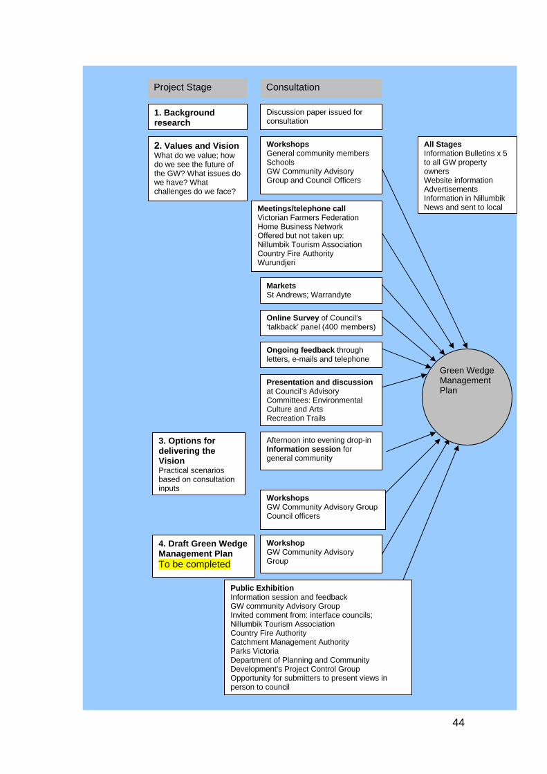
Green Wedge Management Plan
2. Values and Vision What do we value; how do we see the future of the GW? What issues do we have? What challenges do we face?
Afternoon into evening drop-in Information session for general community
Workshops GW Community Advisory Group Council officers
WorkshopsGeneral community members Schools GW Community Advisory Group and Council Officers
Meetings/telephone callVictorian Farmers Federation Home Business Network Offered but not taken up: Nillumbik Tourism Association Country Fire Authority Wurundjeri
Online Survey of Council’s ‘talkback’ panel (400 members)
MarketsSt Andrews; Warrandyte
Ongoing feedback through letters, e-mails and telephone
Presentation and discussion at Council’s Advisory Committees: Environmental Culture and Arts Recreation Trails
3. Options for delivering the Vision Practical scenarios based on consultation inputs
Consultation Project Stage
4. Draft Green Wedge Management Plan To be completed
WorkshopGW Community Advisory Group
1. Background research
Discussion paper issued for consultation
Public Exhibition Information session and feedback GW community Advisory Group Invited comment from: interface councils; Nillumbik Tourism Association Country Fire Authority Catchment Management Authority Parks Victoria Department of Planning and Community Development’s Project Control Group Opportunity for submitters to present views in person to council
All StagesInformation Bulletins x 5 to all GW property owners Website information Advertisements Information in Nillumbik News and sent to local
44
Scenarios for the future Feedback to the Scenarios paper represented a pivotal point in the consultation process. It drew together the ideas and views coming through consultation into four possible futures, or scenarios, for the Nillumbik Green Wedge. The Scenarios paper was advertised through Green Wedge Bulletin issue 3, March 2008 and a public information session was held at Hurstbridge in June. The four scenarios aimed to provoke discussion about how a future Nillumbik Green Wedge might look. In addition to environmental protection concerns, it asked respondents to consider where people are going to live and work. The scenarios were:
a) A do-nothing future, where the cumulative impact of small, incremental changes lead to long term impacts on the environment
b) emphasis on protecting the Nillumbik Green Wedge from change as the primary consideration
c) a positive attitude to developing housing in areas that are not environmentally sensitive or set aside for particular uses (e.g. agriculture), and investigating the creation of new ‘hamlets’ or small towns
d) a conservation model based on the UK’s national parks and involving a new governance framework. This manages the Nillumbik Green Wedge at a landscape scale for conservation and promotes people’s enjoyment of the Nillumbik Green Wedge.
Community feedback to the Scenarios paper produced consensus on key issues for the GWMP as well as a range of divergent views.
Consensus
There is broad agreement on the following.
1. Protecting the environment is the most important factor for the Nillumbik Green Wedge. Where people differ is in the extent of protection required.
2. Move away from one-size-fits-all policies: systematically determine what needs protecting (and what does not) and look after it through planning controls, enforcement and education.
3. Support landholders to look after the Nillumbik Green Wedge and recognise that bushfire is a huge risk.
4. Living in the Nillumbik Green Wedge is different. Urban or suburban levels of infrastructure will not necessarily be available or appropriate in isolated rural areas.
5. Emphasis should be placed on sustainable and renewable energy.
6. A circular public transport service linking Nillumbik Green Wedge townships is needed.
7. Nillumbik has a great opportunity to be a leader in passive recreation; the impact of demand from neighbouring municipalities has to be factored in.
8. Farming is of great value to the Nillumbik Green Wedge in terms of landscape, environmental and economic benefits. Farming is not self-sufficient and farmers need to be supported through policy and in practical ways (similar to the type of support given to farmers in Europe), to retain agricultural land for future food production.
45
9. Well planned and low impact tourism is a good thing and an opportunity for Nillumbik.
10. How council will fund the management of the Nillumbik Green Wedge is a central issue which has to be addressed.
Differences and finding a middle way Differences of opinion exist in the following areas although, frequently, there is a middle way articulated by community members. Where this is the case, it is also recorded below. The extent of protection for the environment One perspective is to tighten controls and enforcement; the opposite is that too many controls infringe people’s property rights. The middle way perspective is that a balance between environmental protection and the enjoyment of residents is needed, that change is inevitable and how we manage that change is important. This perspective recognises that Nillumbik Green Wedge land should not be viewed as speculative land, for development one piece at a time, but neither should we drive a heavy-handed environmental agenda at the expense of enjoyment. Tourism, business and the need to have somewhere to live are all important. This perspective wants council to find a way to allow both conservation and use; to protect the environment but balance this with some carefully managed development so that all sectors of the population can benefit. Where will housing go? Some in the community want more development in the Nillumbik Green Wedge and another second group is opposed to it. A third perspective is that we have to move away from the view that conservation is ‘good’ and use ‘bad’ and have a balance between environmental conservation and social and economic sustainability, including housing opportunities. Commercial development One view has it that there should be no commercial development in the Nillumbik Green Wedge and that council should place emphasis on improving existing areas of business rather than creating new ones. This is tempered by the view that identifying and then actively encouraging, the types of business we want in the Nillumbik Green Wedge is the way ahead. Examples are tourism, home-based business and aged-care support. Funding the management of the green wedge While there is agreement that council’s inability to adequately fund management of the green wedge is a central issue, views on how to raise the funds differ. One view is to extend the rates base through more housing. The other is to seek funding from state and federal governments. Council is already addressing this issue with other green wedge councils.
46
Advisory Groups Broad community input was essential to the development of a GWMP. Just as important was the contribution of the advisory groups, who drove and shaped the development. Below is a list of the people and organisations that provided expert advice.
Council officers
Jackie Donkin, Senior Strategic Planner Margaret Abbey, Group Manager Environment and Planning Services (until June 2010) Chad Griffiths, Coordinator Strategic Planning Pat Vaughan, Manager Environment and Strategic Planning (from July 2008), Rachel Haynes, (until March 2008) Andrew Port, Group Manager Corporate Services (from December 2007) Ron Exiner, (until December 2007) Paul Fyffe, Strategic Planner
Officer Technical Working Group
Adrian Cully, Manager Social & Cultural Development Darren Bennett, Manager Leisure Services Tara Frichitthavong, Manager Community Services Jon Miller, Coordinator, Environmental Works (to October 2008) Julie French, Tourism & Business Development Coordinator Donna Stoddart, Coordinator, Environmental Planning Robert Szymanski, Team Leader, Planning (to June 2008) Stuart Caldwell, Manager Planning & Building (to July 2008) Jacqui Hansen, Team Leader, Planning (to July 2008) Jeremy Livingston, Coordinator, Planning Tom Young, Manager Infrastructure Development (to December 2008)
Community Advisory Group for the Green Wedge comprising the following Council committees Environmental Advisory Committee Member – David Nicholls Recreation Trails Committee Member – Sharon Banner Culture and Arts Advisory Committee Member – Jenni Mitchell (until March 2007) Community groups Landcare and Friends of Groups – John Huf Nillumbik Tourism Association – Jan Kelly (until 2007); Ken King (from 2007) Victorian Farmers Federation – Ian McMillan Bend of Islands Grazing Properties – Stephen Hill (until 2008) Bend of Islands Conservation Association – Frank Pierce Green Wedge Protection Group – Kahn Franke Friends of Nillumbik – Sue Aldred (until 2009) Hurstbridge and District Advisory Committee – Pam Lawson Trust for Nature – Lynlee Tozer Community members Dr Geoff Mosley, Janet Mattiske, Anika Van Hulsen, Graeme Hubbert, Liezl Shnookal, Mike Pelling, Bronwyn South, Sue Aldred (from 2009) State agencies Country Fire Authority – Jeff Adair (until 2008); Ray Fritz (from 2008)
47
Other public agencies were consulted through the state government’s Department of Planning and Community Development Project Control Group Victorian Government Department of Planning and Community Development Shirley Diez, Mardi Tress, Emma Shorter (2007), Patsy Martin and Simon Michmacher (2008) DPCD Green Wedges team
Jack Krohn, Patsy Martin, Project Control Group Nillumbik Shire councillors from November 2008 Cr Bo Bendtsen (until 2009), Cr Ken King, Cr Lewis Brock to November 2008 Cr Warwick Leeson (Mayor), Cr Greg Johnson, Cr Peter Yates, Cr Bill Penrose Neighbouring councils Shire of Yarra Ranges – Graham Whitt (until 2008), Graham Bower (until 2009), Claudette Fahy (from 2009); Manningham – Hamish Allan (until 2009), Samantha Bradley (from 2009); Whittlesea – Darren Jackson (until 2008), Tanya Young (from 2008 to 2010)
Terms of reference for the community advisory group Council advertised for applications for membership of the community advisory group and appointed the following organisations and individuals. The original terms of reference are reprinted below. 1 CONTEXT
Nillumbik Shire Council is the Green Wedge Shire and it is committed to protecting and enhancing the natural and cultural environment of Nillumbik. It recognises that people who live in Nillumbik do so because they value the countryside and its native bushland, the rolling farmland, and the opportunity to live in a rural environment with plenty of space around them. The council wishes to prepare a green wedge management plan as a priority so that these values can be conserved and enhanced and so that the natural environment remains as a legacy for future generations to enjoy. The green wedge management plan will not be developed in a vacuum. The existing planning framework is already in place through the Nillumbik Planning Scheme and this defines the main areas of urban and rural land through a series of zones and overlays and associated regulations. These provisions include the urban growth boundary, which sets limits to urban growth and Green Wedge Zones, which set the framework within which the management plan is to be developed. The Green Wedge Zones which cover approximately 90 per cent of the shire are applied outside the urban areas and exclude townships such as Hurstbridge, Wattle Glen, Panton Hill and St Andrews. The council wishes to prepare a plan which has the backing of the community and which describes a vision for the Nillumbik Green Wedge which has a consensus of support. It believes that the plan will not be successful unless it has the broad backing of local people and local businesses and those who have a ‘stake’ in the green wedge and its values.
48
CONTEXT continued ...
Council therefore wishes to establish a community advisory group to assist in this process and to help inform the development of the green wedge management plan. Although the advisory group will be an important part of the community consultation process, there will be extensive further consultation to ensure that people are kept informed of progress and have a real opportunity to affect development of the plan. The plan will also contribute to better planning for the broader metropolitan area and can help to make Melbourne a more sustainable city in line with the values set out in Melbourne 2030.
2 PURPOSE
The purpose of the community advisory group is therefore to help develop a green wedge management plan for the Shire of Nillumbik. It will be advisory rather than decision-making, because decisions will by necessity remain with the elected representatives of the council itself. However, the advisory group is intended to be a 2-way communication between the community and the council and will be a sounding board on community values and aspirations. advisory group members will also communicate information and progress on the plan to the wider community and local interest groups. The objectives of the advisory group can therefore be summarised as follows:
To provide community input to the green wedge management plan To represent the views and values of the broader community and interest
group which they represent - rather than individual interests To assist and support the project team to prepare and deliver the plan To provide information, advice and feedback as needed to help inform and
improve the development of the plan To help inform the wider community about the development of the plan and
progress The group would be set up to help prepare the green wedge management plan and so will have a limited life. When the plan has been prepared and adopted by council, the group will have completed its work.
3 OUTPUTS
A work program for the development of the green wedge management plan has not yet been finalised nor approved by council. However it is anticipated that the plan will be developed over the course of 12 months and that the advisory group will meet at key stages over that time to provide input, to review draft papers, and to advise on key issues. Key outputs from the program will be identified at an early stage and referred to the advisory group for information and feedback.
49
4 PROCEDURAL
The advisory group should generally expect to meet quarterly through the course of the project or as necessary to consider key issues and draft papers. The venue will be the municipal offices at Greensborough and meetings will be held outside office hours on a weekday (or at a time agreed upon by the group). Representation on the advisory group has not yet been finalised but is likely to consist of approx 20 ‘stakeholders’ representing a diversity of community interests and values. Meetings will be chaired by the mayor and supported by the project team and specialist consultants as necessary. The normal conventions for meetings and advisory groups will be expected in terms of behaviour and respect for colleagues, participation, attendance, and reporting. Whilst a consensus on issues may be desirable, it is not mandatory and divergent views will be recorded and taken into account. Agendas and papers for meetings will be circulated in advance of meetings and a record of discussion will be circulated afterwards. It will be important to create an open and trustworthy environment at meetings so that all views can be represented and heard.
5 RESOURCING
Day to day support for the advisory group will be provided by the Green Wedge Project Team which will be headed by Claudette Fahy, Coordinator Strategic Planning. She can be contacted on 9433 3215 or by email via [email protected]. Specialist consultants may be engaged to assist in preparing the plan and they will attend and present to meetings as necessary.
50
Abbreviations and terms The following abbreviations and terms are used in this plan. Activity centre ‘Activity centres are vibrant hubs where people shop, work, meet,
relax and often live. Usually well served by public transport, they range in size and intensity of use from local neighbourhood strip shopping centres to universities and major regional shopping malls. Linking them to good transport networks (road, public transport, pedestrian and cycle) is crucial as they attract high numbers of people and generate a significant volume of trips in metropolitan Melbourne. They are a central part of Melbourne 2030, which will encourage more development into activity centres to foster more sustainable, more vibrant communities and will be the focus of major change over the next 30 years.’ <http://www.dse.vic.gov.au>
Agricultural, or farm viability (includes technical viability)
The Shire of Nillumbik’s Land Capability Study (Woodward-Clyde, 1998) differentiates between technical viability and farm viability. Technical viability refers to whether a farm has potential for agricultural production in a sustainable way and is not a measure of its economic performance. Farm viability refers to whether production is economically viable: does it make sufficient income to service borrowings, provide a family with an adequate standard of living, allow investment in the farm and demonstrate ecological sustainability? (Nillumbik Shire Council 2006, p. 25)
Biodiversity Biodiversity refers to the full range of variety and variability within and among living organisms and the ecological complexes in which they occur. It encompasses ecosystem or community diversity, species diversity and genetic diversity.
Carbon footprint A carbon footprint is a measure of the impact of human activities on the environment in terms of the amount of greenhouse gases produced, measured in units of carbon dioxide.
Climate change Climate change refers to the change in climate predicted to arise from human activities. This is predominantly attributed to an enhanced greenhouse effect which is the process whereby an increase in greenhouse gases including carbon dioxide (CO2), water vapour and methane, which are in the air closest to the earth’s surface, absorb outgoing radiant heat and radiate some of this heat back downwards to warm the surface of the earth.
Conservation ‘Conservation means all the processes and actions of looking after a place so as to retain its natural significance and always includes protection, maintenance and monitoring’. ‘In making decisions that will affect the future of a place, it is important to consider all of its heritage values – both natural and cultural … The Charter relates closely to the general structure and logic of The Burra Charter – the Australia ICOMOS Charter for Places of Cultural Significance 1999’ (Australian Natural Heritage Charter).
CSIRO Commonwealth Scientific and Research Organisation
51
Cultural significance ‘Australian conservation practice… is based on the concept of cultural significance i.e. that the values of a place can be described and that retaining significance is the primary objective of conservation. Some acts use slightly different terms – such as “heritage significance” or “cultural heritage value” – but the concept is the same as cultural significance.’ Cultural significance is embodied in a place, its fabric, setting, use, associations and meanings. A given place may have a range of values for different individuals or groups. In heritage practice the significance of a place is assessed in terms of five values: aesthetic, historic, scientific, social and spiritual value (Walker and Marquis-Kyle 2004)
Ecological footprint Ecological footprint analysis compares human demand on nature with the biosphere's ability to regenerate resources and provide services. It does this by assessing the biologically productive land and marine area required to produce the resources a population consumes and to absorb the corresponding waste, using prevailing technology.
Ecotourism ‘Ecologically sustainable tourism with a primary focus on experiencing natural areas that fosters environmental and cultural understanding, appreciation and conservation’, Ecotourism Australia
Enhance (as in conserve and enhance)
‘Enhancement means the introduction of additional organisms, genotypes, species or elements of habitat or geodiversity to those that naturally exist in a place.’ (Article 1.26 Australian Natural Heritage Charter)
Green wedge ‘Green wedges are the open landscapes that were set aside, more than 30 years ago, to conserve rural activities and significant natural features and resources between the growth areas of metropolitan Melbourne as they spread out along major roads and rail links.’ (DPCD 2008)
Green wedge management plan (GWMP)
The GWMP sets out objectives, strategies and actions to manage the Nillumbik Green Wedge
Heritage values See cultural significance Intellectual access This term implies that access to the Nillumbik Green Wedge will not
only be physical access but will include interpretation materials suited to a range of different audiences and learning styles. It is in line with interpretation best practice.
Interface councils The interface councils are located on the fringes of Melbourne. They are Cardinia, Hume, Melton, Mornington Peninsula, Nillumbik, Whittlesea, Wyndham and Yarra Ranges. These councils define themselves as 30 per cent urban and 70 per cent rural, forming the interface between regional and metropolitan Victoria.
Landscape values The value of a landscape is a combination of vegetative cover and wildlife and visual qualities, including landform features and views and the value placed on it by a community or communities. Landscape values contribute greatly to amenity and are an attraction for residents and visitors.
LGA Local Government Association Melbourne 2030 (M2030)
The Victorian Government’s planning strategy for Melbourne.
Municipal Strategic Statement (MSS)
A statutory document that guides future land use and development in the Shire of Nillumbik.
52
Peak oil Peak oil is the point in time when the maximum rate of global petroleum extraction is reached, after which the rate of production enters terminal decline.
SEIFA Social Economic Index for Areas is an analytical tool used to assess socio-economic wellbeing and identify areas of advantage and disadvantage.
SLA Statistical Local Area Sustainability Refers in its simplest form to the utilisation of resources at a level
that can be maintained into the distant future and in a manner that does not irreversibly damage natural ecosystems and human societies.
Sustainable tourism ‘Sustainable tourism development meets the needs of present tourists and host regions while protecting and enhancing opportunities for the future. It is envisaged as leading to management of all resources in such a way that economic, social and aesthetic needs can be fulfilled while maintaining cultural integrity, essential ecological processes, biological diversity and life support systems’ (Department of Environment and Heritage 2004).
Technical viability See Agricultural or farm viability. UGB (urban growth boundary)
The urban growth boundary is a tool that the government introduced in 2002 to help contain Melbourne’s outward growth.
53
Bibliography Australian Bureau of Statistics, Population projections <http://www.abs.gov.au/Ausstats/[email protected]/mf/3222.0>, viewed 30 October 2008 Australian Bureau of Statistics 2007, 2006 Census, ABS, http://wwww.id.com.au/profile/default.aspx?id=140, viewed 16 March 2009 Australian Natural Heritage Charter <http://www.environment.gov.au/heritage/ahc/publications/commission/books/australian-national-heritage-charter.html> ‘Australians ranked among the world’s worst eco-offenders’, The Age, 30 October 2008, p. 5 Beardsell, C 1997, Sites of faunal and habitat significance in north-east Melbourne, Nillumbik Shire Council, Greensborough Butler, G & Associates 1996, Nillumbik Shire Heritage Study: Environmental History Stage 1, Vol. 2 Clark, N & Associates 1998, Nillumbik Shire commodity and economic profiles, Nillumbik Shire Council, Greensborough Commissioner for Environmental Sustainability 2008, Victoria – State of the Environment, Victorian Government, Melbourne Context Pty Ltd August 2008, Knox City Council: 2008–2018 Sustainable Environment Strategy, Knox City Council, <www.knox.vic.gov.au/Page/Download.asp?name=Knox_Sustainable_Environment_Strategy.pdf&size=1419406&link=../Files/Knox_Sustainable_Environment_Strategy.pdf> Countryside Agency and Scottish Natural Heritage 2002, Landscape Character Assessment: Guidance for England and Scotland, <http://www.countryside.gov.uk/images/LCA_guidance_tcm2-19316.pdf>, viewed 25 May 2007 Countryside Agency 2006, Landscape: beyond the view, <www.landscapecharacter.org.uk>, viewed 25 May 2007 Department of Environment and Heritage 2004, Steps to sustainable tourism, Department of Environment and Heritage, Canberra Department of the Environment, Sport and Territories 1996, National Strategy for the Conservation of Australia's Biological Diversity, <http://www.environment.gov.au/biodiversity/publications/strategy/chap2.html>, viewed 7 May 2008, Department of Environment, Sport and Territories, Canberra Department of Human Services (Victoria) 2001, Environments for health – promoting health and wellbeing through built, social, economic and natural environments: municipal health planning framework, DHS, Melbourne
54
Department of Planning and Community Development (Victoria) 2008a, Planning for all of Melbourne, the Victorian Government response to the Melbourne 2030 audit, DPCD, Melbourne Department of Planning and Community Development (Victoria) 2008b, Melbourne @ 5 Million – full report, <http://www.dse.vic.gov.au/DSE/nrenpl.nsf/LinkView/1352EB2F109044AFCA2575120016BE8B718331E8AB7D9987CA256D1900299B45>, DPCD, Melbourne, viewed 11 March 2009 Department of Planning and Community Development (Victoria) 2008c, Melbourne @ 5 Million – Fact Sheet, <http://www.dse.vic.gov.au/DSE/nrenpl.nsf/LinkView/1352EB2F109044AFCA2575120016BE8B718331E8AB7D9987CA256D1900299B45>, DPCD, Melbourne, viewed 15 December 2008 Department of Primary Industries (Victoria) 2008a, Future Farming: Productive, Competitive, Sustainable, DPI, Melbourne Department of Primary Industries (Victoria) 2008b, Square Pegs in Green Wedges, DPI, Melbourne Department of Sustainability and Environment (Victoria) 1997, Victoria’s Biodiversity Strategy – Sustaining our Living Wealth, DSE, <http://www.dse.vic.gov.au/dse/nrence.nsf/LinkView/EFAC7933C595DA23CA256EE7000B6CCC1C26CB3A9ABC1C2FCA256EE700148D0B>, viewed 8 May 2008 Department of Sustainability and Environment (Victoria) 2003, Planning Provisions for Melbourne’s Green Wedges, DSE, Melbourne Department of Sustainability and Environment (Victoria) 2005, Principles, issues and guidelines for the preparation of green wedge management plans, DSE, Melbourne Department of Sustainability and Environment (Victoria) 2006, Our Environment, Our Future – Sustainability Action Statement 2006, Fact Sheet, DSE, <http://www.dse.vic.gov.au/ourenvironment-ourfuture/downloads.htm>, viewed 23 December 2008 Department of Sustainability and Environment (Victoria) 2008, Land and biodiversity at a time of climate change, Green Paper, DSE, Melbourne Department of Transport (Victoria) 2006, Meeting our Transport Challenges, DoT, <http://www.transport.vic.gov.au/DOI/Internet/planningprojects.nsf/AllDocs/80E779DD0C35BA08CA2573AE000509F0?OpenDocument>, viewed 28 May 2008 Department of Transport (Victoria) 2007, North East Integrated Transport Study (NEITS), DoT, <http://www.transport.vic.gov.au/Doi/Internet/planningprojects.nsf/AllDocs/8D2A24F5A2FB7552CA256F3200257724?OpenDocument#neits>, viewed 28 May 2008 Diamond Creek sub catchment Working Group 1999, Diamond Creek sub catchment – Local Action program
55
Dovers, S 2008, ‘Policy and Institutional Reforms’ in Ten Commitments Reshaping the Lucky Country’s Environment, eds D Lindenmayer, S Dovers, M Harriss Olsen, S Morton, CSIRO Publishing, Collingwood, Victoria Ellender, I 1994, The Aboriginal Heritage of the Shire of Eltham, unpublished study Essential Economics 2008, Nillumbik Green Wedge Management Plan Economic Research, Nillumbik Shire Council, Greensborough Flora and Fauna Guarantee Act 1988, s. 4, <http://www.austlii.edu.au/au/legis/vic/consol_act/fafga1988205/s4.html>, viewed 7 May 2008 Foran, B, Gurran, N 2008 ‘Population reforms’ in Ten Commitments Reshaping the Lucky Country’s Environment, eds D Lindenmayer, S Dovers,M Harriss Olsen, S Morton, CSIRO Publishing, Collingwood, Victoria Goldie, J 2005 ‘Population, the great multiplier’ in In Search of Sustainability, eds J Goldie, B Douglas,B Furnass, CSIRO Publishing, Collingwood, Victoria Harris, G 2005, Melbourne’s Green Belt and Wedges, School of Social Science and Planning, RMIT University, Melbourne Hatfield-Dodds, S, Proctor, W 2008, Delivering on the Promise of Stewardship: issues in realising the full potential of environmental stewardship payments for landholders and the land, a discussion paper prepared for the Australian Conservation Foundation, CSIRO Sustainable Ecosystems, Canberra Hughes, L 2008, ‘Climate change’ in Ten Commitments Reshaping the Lucky Country’s Environment, eds D Lindenmayer, S Dovers,M Harriss Olsen, S Morton, CSIRO Publishing, Collingwood, Victoria Jeavons and Jeavons 2000, Preliminary progress report Open Space Strategy, pp. 49–54, cited in Nillumbik Shire Council 2005, Open Space Strategy, Appendix 2, pp. 2–4, Nillumbik Shire Council, Greensborough Johns, D, The Kinglake Fires –- January 2006 Knox, A 1985, Living in the Environment, Second back Row Press, NSW Knox, A We are what we stand on, Adobe Press, Eltham Land and Water Australia 2003, Biodiversity Conservation in Regional NRM Planning research project VRA1 Fact sheet: September 2003, <http://downloads.lwa2.com/downloads/publications_pdf/PF030618.pdf> viewed 7 May 2008 Lowe, Ian, 2005 ‘Achieving a sustainable future’ in In Search of Sustainability, eds J Goldie, B Douglas, B Furnass, CSIRO Publishing, Collingwood, Victoria Lowe, Ian, 2008 ‘Energy’ in Ten Commitments Reshaping the Lucky Country’s Environment, eds D Lindenmayer, S Dovers, M Harriss Olsen, S Morton, CSIRO Publishing, Collingwood, Victoria
56
Maribyrnong City Council, Peak Oil Policy, <http://www.maribyrnong.vic.gov.au/Files/PeakOilPolicy.pdf>, viewed 7 May 2008 Melbourne and Metropolitan Board of Works 1981, Metropolitan Strategy Implementation Melbourne Water Corporation 2007, Port Phillip and Westernport Regional River Health Strategy, Melbourne Water, Melbourne Mitchell, N 2004, ‘Landscape-scale conservation: grappling with the green matrix’, cited in Levitt, J N, Land Lines vol.16, no.1, Lincoln Institute of Land Policy <http://www.lincolninst.edu/pubs/PubDetail.aspx?pubid=869> viewed 28 May 2008 Nillumbik Shire Council 2000, Draft Hurstbridge township strategy, Nillumbik Shire Council, Greensborough Nillumbik Shire Council 2001a, Integrated Transport Strategy, Nillumbik Shire Council, Greensborough Nillumbik Shire Council 2001b, Sustainable Water Management Plan, Nillumbik Shire Council, Greensborough Nillumbik Shire Council December 2006, Green Wedge: Background paper, Nillumbik Shire Council, Greensborough Nillumbik Shire Council 2005, Open Space Strategy, Nillumbik Shire Council, Greensborough Nillumbik Shire Council February 2007, Green Wedge: Discussion paper, Nillumbik Shire Council, Greensborough Nillumbik Shire Council 2009, Council Plan 2009–2013, Nillumbik Shire Council, Greensborough Nillumbik Shire Council, 2008, Draft Climate Change Action plan: 2008-2015, Nillumbik Shire Council, Greensborough Nillumbik Shire Council Municipal Strategic Statement, Nillumbik Shire Council, Greensborough Nillumbik Tourism Association 2008, Business Plan, Nillumbik Tourism Association, <http://www.nillumbiktourism.com/?PK_PAGE_ID=803> viewed 7 May 2008 Outer Suburban/interface Services and Development Committee 2010, Final report on the Inquiry into Sustainable Agriculture in Outer Melbourne Parks Victoria 2002, Linking people and spaces, Victorian Government, Melbourne Port Phillip and Westernport CMA 2000, Port Phillip and Westernport Native Vegetation Plan, Port Phillip and Westernport CMA, Frankston Port Phillip and Westernport CMA, 2002/3, Sustainability Objectives for natural resource management in the Port Phillip and Westernport region, Port Phillip and Westernport CMA, Frankston
57
58
Possingham, H 2008, ‘Biodiversity Reforms’ in Ten Commitments Reshaping the Lucky Country’s Environment, eds D Lindenmayer, S Dovers, M Harriss Olsen, S Morton, CSIRO Publishing, Collingwood, Victoria Sciusco, L 1996, Nillumbik Shire Council Aboriginal Heritage Study, unpublished study Scott, J M 2002, ‘Measuring whole farm sustainability and profitability at a credible scale’, Proceedings of the Fenner Conference on the Environment, Chicago State University, <http://www.csu.edu.au/special/fenner/> viewed 31 December 2008 Sustainability Victoria 2008, Green Light Report – Victorians and the Environment, Sustainability Victoria, <http://www.sustainability.vic.gov.au/www/html/2698-green-light-report.asp?intSiteID=4> viewed 23 December 2008 Tilbury, D, Wortman, D 2008, Engaging people in sustainability, IUCN Publications, Cambridge, UK Tourism Victoria 2007,Sustainability in Tourism, <www.tourismexcellence.com.au//sustainability-in-tourism.html> viewed 7 May 2008 Walker, M & Marquis-Kyle, P 2004, The illustrated Burra Charter: good practice for heritage places, Australia ICOMOS inc., Burwood Western Australian Government 2003, State Sustainability Strategy <http://www.dec.wa.gov.au/our-environment/sustainability/state-sustainability-strategy.html>, viewed 23 December 2008 Whittlesea City Council 2008, ‘About Whittlesea’, Whittlesea City Council website, <http://www.whittlesea.vic.gov.au/content/content.asp?cnid=949>, viewed 15 December 2008 Woodward-Clyde 1998, Nillumbik Shire Council Land Capability Study, Nillumbik Shire Council, Greensborough


![SHIRE OF NILLUMBIK | LANDSCAPE CHARACTER ......Nillumbik Landscape Character Assessment [ Final Report ] 1.2 Study Process The study was undertaken in six stages: Stage 1: Inception](https://img.pdfslide.net/doc/110x75/5f026c7e7e708231d4043383/shire-of-nillumbik-landscape-character-nillumbik-landscape-character-assessment.jpg)