Embed Size (px)
Citation preview

NOAA-20 CrIS SDR Beta Maturity Report 25 January 2018
NOAA-20 CrIS SDR Beta Maturity Status Report
January 25, 2018
CrIS SDR Team
With contributions from NOAA/STAR, NASA/GSFC, Harris, UW/SSEC, UMBC, UMD/CICS, SDL/USU, MIT/LL, Logistikos, Raytheon

NOAA-20 CrIS SDR Beta Maturity Report 25 January 2018
Outline
• Algorithm Cal/Val Team Members• NOAA-20 CrIS Cal/Val Time Line• NOAA-20 CrIS First Global Coverage Image• CrIS Instrument Performance
– On-orbit NEdN– DA Bias Tilt– Metrology Laser Set Optimization– Gain Setting– Bit Trim/Impulse Noise Mask Check– On-Orbit Torque Null Position Update for In-Track Angles
• CrIS SDR Performance– Radiometric Calibration Accuracy – Spectral Calibration Accuracy– Geolocation Accuracy
• Summary and Path Forward
Page | 2

NOAA-20 CrIS SDR Beta Maturity Report 25 January 2018
Cal/Val Team MembersPI Organization
Changyong Cao (acting) NOAA/STAR
Dave Tobin U. of Wisconsin (UW)
Larrabee Strow U. of Maryland Baltimore County (UMBC)
Deron Scott Space Dynamic Lab (SDL)
Dan Mooney MIT/LL
Dave Johnson NASA Langley
Lawrence Suwinski Harris
Joe Predina Logistikos
Deirdre Bolen JPSS/JAM
Wael Ibrahim Raytheon
• Big thanks for the dedicated and hard work of each of the contributing organizations• Team work has been and continues to be exceptional

NOAA-20 CrIS SDR Beta Maturity Report 25 January 2018 L + 90 (2/16/18) - - - - - - - - - - - - - - - - - - - - - - - - - - - - - - - - - - - - - - - - - - - - - - - - - - - - - - -
Page | 4
L + 46 (1/3/18) - - - - - - - - - - - - - - - - - - - - - - - - - - - - - - - - - - - - - - - - - - - - - - - - - - - - - -
End Outgassing; Deploy Cooler Door; Initial Cal Table
upload(v112) Instrument Stable
L + 47 (1/4/18) - - - - - - - - - - - - - - - - - - - - - - - - - - - - - - - - - - - - - - - - - - - - - - - - - - - - - -Science Data Available (L+48)First Earth view science data available
L + 60 (1/17/18) - - - - - - - - - - - - - - - - - - - - - - - - - - - - - - - - - - - - - - - - - - - - - - - - - - - -Second Cal Table (v113)
upload with PGA gain and new Neon Wavelength and
ILS parameters
Third Cal Table Upload v114
L + 11 (11/29/17) - - - - - - - - - - - - - - - - - - - - - - - - - - - - - - - - - - - - - - - - - - - - - - - - - - - -Begin Outgassing
Flight Activity Ground Activity
CrIS Diode Temp, IR Gain Check, BTM, Impulse Noise Mask Check, Jitter Performance, etc
SDR data available (Beta Maturity L+68), Spectral Cal/Laser Stability, Detector Noise/Linearity, Full Res Diagnostic,
Geolocationa2, ILS parameters Delivered w/STAR input (L+85)
JPSS-1 LaunchL + 0 (11/18/17) - - - - - - - - - - - - - - - - - - - - - - - - - - - - - - - - - - - - - - - - - - - - - - - - - - - - - -
Provisional Maturity
NOAA-20 CrIS SDR Cal/Val Timeline

NOAA-20 CrIS SDR Beta Maturity Report 25 January 2018
Beta Maturity Definition
Page | 5

NOAA-20 CrIS SDR Beta Maturity Report 25 January 2018
NOAA-20 SDR Calibration Uncertainty Specifications
Page | 6
Band Spectral range (cm-1)
N. of chan.
Resolution (cm-1)
FORs per
Scan
FOVs per FOR
NEdN@287K BB
mW/m2/sr/cm-1
Radiometric Uncertainty@287K BB
(%)
Spectral (chan center) uncertainty
ppm
GeolocationuncertaintyKm (Nadir)
LW 650-1095 713 0.625 30 9 0.14 0.45 10 1.5
MW 1210-1750 433 1.25 30 9 0.06 0.58 10 1.5
SW 2155-2550 159 2.5 30 9 0.007 0.77 10 1.5
Band Spectral range (cm-1)
N. of chan.
Resolution (cm-1)
FORs per
Scan
FOVs per FOR
NEdN@287K BB
mW/m2/sr/cm-1
Radiometric Uncertainty@287K BB
(%)
Spectral (chan center) uncertainty
ppm
GeolocationuncertaintyKm (Nadir)
LW 650-1095 713 0.625 30 9 0.14 0.45 10 1.5
MW 1210-1750 865 0.625 30 9 0.084 0.58 10 1.5
SW 2155-2550 633 0.625 30 9 0.014 0.77 10 1.5
Normal Spectral Resolution
Full Spectral Resolution
Radiometric uncertainty specification converted to Brightness Temperature (BT)

NOAA-20 CrIS SDR Beta Maturity Report 25 January 2018
NOAA-20 CrIS First Light Images• On Jan 5, 2018, forty-eight days after NOAA-20 was launched into Earth orbit, it sent back
its first Cross-track Infrared Sounder (CrIS) science data. • All three bands are working nominally, IDPS successfully generated both Normal Spectral
Resolution (NSR) and Full Spectral Resolution (FSR) SDR data.
Page | 7

NOAA-20 CrIS SDR Beta Maturity Report 25 January 2018
NOAA-20 CrIS First Light Images
Page | 8

NOAA-20 CrIS SDR Beta Maturity Report 25 January 2018
NEdN Compares well to 287K ECT TVAC NEdN – Full Spectral Resolution
• MW9 NEdN elevated as expected from prelaunch TVAC measurements but within specification
• LW7 NEdN elevated (high noise had been seen once before during EMI test phase)• NEdN calculated on 1-8 is very similar to prelaunch TVAC test results• NOAA-20 NEdN are comparable to S-NPP
Page | 9
Earth view data on 01/21/2018, from 23:40:16 to 23:59:28
ECT TVAC
(Specification using NSR, need to times 1.4 and 2.0 for FSR data for MWIR and SWIR, respectively)

NOAA-20 CrIS SDR Beta Maturity Report 25 January 2018
ICT NEdN Become Betterafter Instrument Temperature Stable
Page | 10
ICT NEdN on 01/05/2018
ICT NEdN on 01/21/2018

NOAA-20 CrIS SDR Beta Maturity Report 25 January 2018
DA Tilt Time History Total Tilt Value Better than S-NPP
S-NPP Example Total Tilt 0.234 urad
J1 Example Total Tilt 0.123 urad
Page | 11

NOAA-20 CrIS SDR Beta Maturity Report 25 January 2018
Optimal Laser Set PointFSR Extended Length Interferogram
Page | 12
Wavelength (nm)
Stem
Lin
es a
re a
t Fo
ld I
ndex
Cha
nge
Wav
elen
gth
Poin
ts
Base Laser Wavelength1547.64725 nm
-5 ppm Change inWavelength after ILS tuning1547.6395 nmSWIR Index
Change Point
LWIR MWIR SWIR
MWIR Index Change Point
78 ppm
145 ppm
Current Laser Wavelength is Well Outside keep-out Zones

NOAA-20 CrIS SDR Beta Maturity Report 25 January 2018
Gains Verified with Hottest Scene & Trended Over Several Days for Additional Confirmation
Earth Scene ZPD Amplitude trending confirmed gain setting is final• Gain setting on 1/9 (during 21:00 GMT) provides margin for bands/FOVs• ES ZPD amplitudes trended from 1/9 (post gain set) through 1/14• Hottest scene observed from South Africa pass on 1/11 (12:00-13:00 GMT)
• Actual pass is 12:35:45 – 12:39:15 (~ 32ᵒ42’S & 18ᵒ42’E to 22ᵒ41’S & 14ᵒ32’E)• Corresponds to apparent brightness temperature of about 336.7K• Max absolute ES ZPD Amplitudes for the pass shown below
Band LW MW SWFOV1 7120 3168 4752FOV2 6496 3040 4528FOV3 7088 3120 5152FOV4 6704 3232 4704FOV5 5728 2912 4544FOV6 6272 2928 4800FOV7 6752 3264 5200FOV8 6576 3280 4976FOV9 6864 3008 4592Max 7120 3280 5200
Page | 13

NOAA-20 CrIS SDR Beta Maturity Report 25 January 2018
ES ZPD Trending
• ES ZPD trending show gain set provides margin against max 8192 counts
• Occasional high or saturated single sample in SW FOVs from sun glint are not considered for gain or bit trim setting.
• Need future investigation why the MW ES ZPD gain so low
Page | 14

NOAA-20 CrIS SDR Beta Maturity Report 25 January 2018
NOAA-20 Bit Trim and Impulse Mask
Bit Trim Mask and Impulse Mask assessed with the hot scene data1. Full Spectral Resolution Bit Trim Mask launched with instrument is
sufficient• Includes the extended samples for LW and SW• No change to data rate
2. NOAA-20 impulse now at same levels as S-NPP• Open at ZPD and 1 bit down elsewhere
J1 FSR LWIR Bit Trim Table
Start Sample Index*
End Sample Index*
Bits Remaining
1 55 1156 96 1397 380 12381 426 13427 450 18451 496 13497 780 12781 821 13822 876 11
J1 FSR SWIR Bit Trim Table
Start Sample Index*
End Sample Index*
Bits Remaining
1 94 895 149 9150 243 8244 324 9325 377 10378 379 10380 429 15430 431 10432 484 10485 565 9566 659 8660 714 9715 808 8
Start Sample Index*
End Sample Index*
Bits Remaining
1 116 10117 316 11317 507 12508 509 12510 543 17544 545 12546 736 12737 936 11937 1052 10
J1 FSR MWIR Bit Trim Table
* After Decimation.
Page | 15

NOAA-20 CrIS SDR Beta Maturity Report 25 January 2018
Bit Trim Mask for NOAA-20
• Real component for hottest scene: South Africa Pass 1/11/18 12:00-13:00 GMT
• Imaginary component also within the mask – 1 bit (for sign) levels
Page | 16

NOAA-20 CrIS SDR Beta Maturity Report 25 January 2018
NOAA-20 SSM On-Orbit Null Torque Updates IT Angles
SSM Geolocation ROP performed on 1/12 during 23:00 hrGMT• SSM Velocity and Motion Compensation disabled• SSM Commanded In-Track Position set to zeroNull Torque value is the In-Track offset position • Some cross-coupling seen in IT from movement of the CT
going from ES10 to Space to ICT during test (48 sec collects)
• Zoom in of flat portion shows an average value of ~1542.4 urad vs. 1666 urad ground test value
• In-Track angles decrease by ~0.062 mrad in v113 eng pkt(uploaded 1/17) relative to v112 (uploaded 1/3)
• ~1 mrad offset remains between CrIS and VIIRS• Mapping angles in the engineering packet can be updated
to resolve CrIS and VIIRS offset, though CrIS already meets its geolocation specification.
Page | 17

NOAA-20 CrIS SDR Beta Maturity Report 25 January 2018
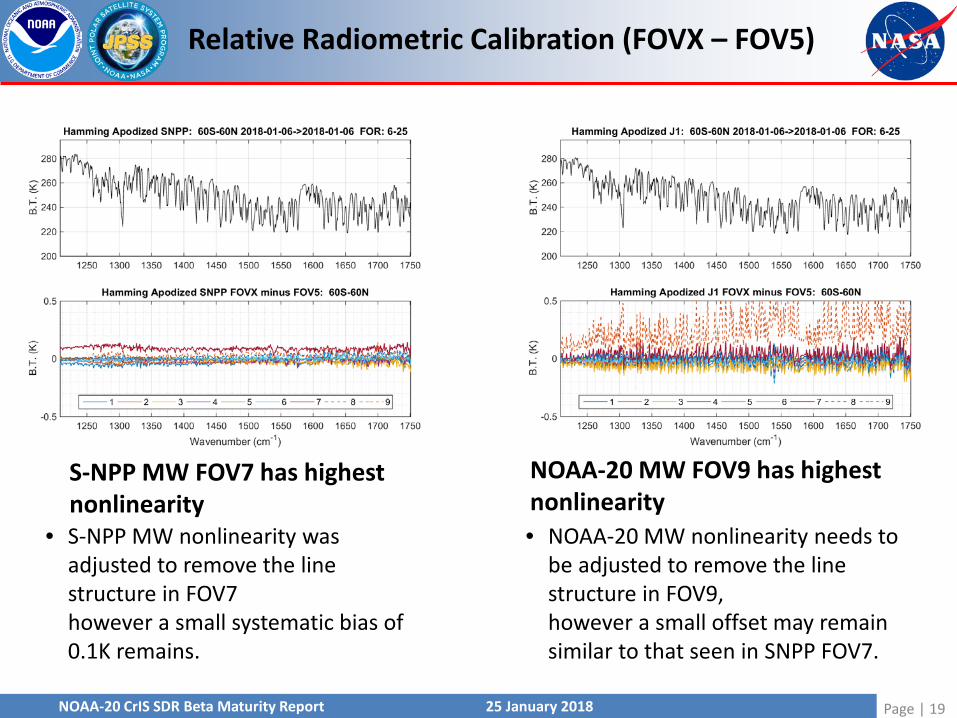
Relative Radiometric Calibration (FOVX – FOV5)
S-NPP LW agreement < 0.15 K
• S-NPP nonlinearity parameters were set during the S-NPP checkout phasein January 2012 but still remain valid six years later.
NOAA-20 LW bias wrt FOV5 ~ 0.2K
• Initial NOAA-20 flight data suggests a small post-launch adjustment to the NOAA-20 LW FOV5 a2 parameterand perhaps some minor refinements of the other FOVs.
Page | 18
NOAA-20 CrIS SDR Beta Maturity Report 25 January 2018
Relative Radiometric Calibration (FOVX – FOV5)
S-NPP MW FOV7 has highestnonlinearity
• S-NPP MW nonlinearity was adjusted to remove the line structure in FOV7however a small systematic bias of 0.1K remains.
NOAA-20 MW FOV9 has highestnonlinearity • NOAA-20 MW nonlinearity needs to
be adjusted to remove the line structure in FOV9,however a small offset may remain similar to that seen in SNPP FOV7.
Page | 19

NOAA-20 CrIS SDR Beta Maturity Report 25 January 2018
Relative Radiometric Calibration (FOVX – FOV5)
S-NPP SW FOV7 & 9 are out-of-family
• S-NPP SW has some issues on spectral lines for FOVs 7 & 9.This is more apparent in unapodizedspectra. (Apodized shown here)
NOAA-20 SW looks better
• NOAA-20 SW band looks very good
Page | 20

NOAA-20 CrIS SDR Beta Maturity Report 25 January 2018
FOV-2-FOV Radiometric Consistency NOAA-20 on 01/05/2018 MWIR FOV 9 out of family
Non-linearity need to be adjusted
Page | 21

NOAA-20 CrIS SDR Beta Maturity Report 25 January 2018
FOV-2-FOV Radiometric Consistency S-NPP on 01/05/2018
Page | 22

NOAA-20 CrIS SDR Beta Maturity Report 25 January 2018
Radiometric AccuracyCompared to Simulation
S-NPP
NOAA-20On 01/05/2018
Page | 23

NOAA-20 CrIS SDR Beta Maturity Report 25 January 2018
Radiometric AccuracyDouble Difference
(BT – BTcrtm)n20 – (BT – BTcrtm) npp
All channels (except one) are with ±0.2 K with S-NPP
Page | 24
Data on 01/05/2018

NOAA-20 CrIS SDR Beta Maturity Report 25 January 2018
Radiometric AccuracyScan Pattern
S-NPP
Page | 25
Data on 01/05/2018

NOAA-20 CrIS SDR Beta Maturity Report 25 January 2018
NOAA-20
Page | 26
Radiometric AccuracyScan Pattern
Data on 01/05/2018

NOAA-20 CrIS SDR Beta Maturity Report 25 January 2018
Northern Hemisphere SNOs, Hamming Apodized CrIS – IASI Bias (CrIS using EP v112)• Variation of results among FOVs in LW CO2 regions• MW FOV9 out-of-family among FOVs• Mean differences generally less than ~0.5K
LW MW SW
Page | 27
Preliminary IASI-B/CrIS SNOs

NOAA-20 CrIS SDR Beta Maturity Report 25 January 2018
Use AIRS as a transfer standard between S-NPP (CrIS-1) and NOAA-20 (CrIS-2)• Convert AIRS L1c to CrIS ILS (AIRS2CrIS)• Find CrIS-1 and AIRS2CrIS SNOs and difference: C1-ARIS• Find CrIS-2 and AIRS2CrIS SNOs and difference: C2-AIRS• (C1-AIRS) minus (C2-AIRS) radiometric differences
Page | 28
Preliminary AIRS/CrIS SNOs
CrIS-2 minus AIRS SNOs (C1- AIRS) - (C2-AIRS) = (C1- C2)

NOAA-20 CrIS SDR Beta Maturity Report 25 January 2018
M16 (~11.8 micron) time series. 4 minute time averages
S-NPP
NOAA-20
Page | 29
Preliminary CrIS/VIIRS Comparisons

NOAA-20 CrIS SDR Beta Maturity Report 25 January 2018
M16 (~11.8 micron) on January 7th
S-NPP NOAA-20
Page | 30
Preliminary CrIS/VIIRS Comparisons

NOAA-20 CrIS SDR Beta Maturity Report 25 January 2018
Spectral Accuracy at LWIRRelative and Absolute (Meet Specification)
NOAA-20
S-NPP
• Absolute spectral shiftFOV 5: -5 ppmFOV 7: +2 ppm FOV 9: +4 ppmOther FOVs: within ± 1 ppm
• Need to adjust FOVs 5, 7 and 9 ILS parameters
Page | 31
Data on 01/05/2018

NOAA-20 CrIS SDR Beta Maturity Report 25 January 2018
Spectral Accuracy at MWIRRelative and Absolute (Meet Specification)
NOAA-20
S-NPP
• Absolute spectral shiftFOV 5: -5 ppmFOV 9: +1 ppm Other FOVs: negative 2 to 3 ppm
• All FOVs ILS parameters need to be adjusted to within 1 ppm
Page | 32
Data on 01/05/2018

NOAA-20 CrIS SDR Beta Maturity Report 25 January 2018
Spectral Accuracy at SWIRRelative and Absolute (Meet Specification)
NOAA-20
S-NPP
• Absolute spectral shiftFOV 5: -5 ppmFOVs 4, 7, and 8: -4 to -5 ppm Other FOVs: negative 2 to 3 ppm
• All FOVs ILS parameters need to be adjusted to within 1 ppm
All on axis FOV 5 in three bands have about 5 ppm shift, which indicate that the true Neon Wavelength is lower than the value current used in the spectral calibration system. Recommended to adjust the Neon Wavelength in the EngPkt v113
Page | 33
Data on 01/05/2018

NOAA-20 CrIS SDR Beta Maturity Report 25 January 2018
FOV-2-FOV Spectral Calibration AnalysisUsing ILS Parameters in EngPkt v113
1) For the ADL FSR SDRs generated by STAR for the case study of 08 Jan 2018, the UW analysis of relative FOV2FOV agrees well with the STAR FOV2FOV analysis, with the notable exceptions of SW FOVs 1, 2, and 3.
2) For radiances generated using the UW matlab cal code (which uses FOVangles generated from the prescribed v113 EP ILS parameters), the relative FOV2FOV behavior is improved over the ADL SDRs.
Page | 34

NOAA-20 CrIS SDR Beta Maturity Report 25 January 2018
Future Improvement:FOV-2-FOV Spectral Calibration Analysis
Page | 35
UW L1B Radiance w/ UMBC FOVangles

NOAA-20 CrIS SDR Beta Maturity Report 25 January 2018
VIIRS M15 CrIS at 900.0 cm-1 CrIS –VIIRS BT Diff.
Collocated CrIS and VIIRS imagesResults indicate some sub-pixel level difference, relative to VIIRS
Page | 36
Geolocation Accuracy

NOAA-20 CrIS SDR Beta Maturity Report 25 January 2018
Geolocation Accuracy (Meet Specification)
Page | 37
Data after EngPkt v113

NOAA-20 CrIS SDR Beta Maturity Report 25 January 2018
VIIRS geolocation update at 0413 UTC on January 5, 2018
Page | 38
Geolocation Accuracy (Meet Specification)
EngPkt v113 upload
Overall performance for CrIS geolocation for all FOV positions:• it already meets the specifications (1.5
km at nadir - 11% of FOV size for all scan positions)
• In-track geolocation having up to about 6% FOV size error, which can be resolved by updating the mapping angles using VIIRS geolocation as reference

NOAA-20 CrIS SDR Beta Maturity Report 25 January 2018
• NOAA-20 CrIS SDR data well meet and exceed the beta maturity: NOAA-20 CrIS SDR data can be used to make initial qualitative or very limited quantitative assessments regarding product fitness-for-purpose
• Major NOAA-20 CrIS SDR data Performance:– NEdN: all FOVs and bands within the specification, comparable well to
S-NPP– Radiometric uncertainty: within the specification, all channels (except
one) are with ±0.2 K with S-NPP (global averaged), showing very good agreement with VIIRS, AIRS, and IASI (less than 0.5 K)
– Spectral uncertainty: within the specification, FOV 5 absolute spectral shift within 1 ppm, relative shift within 3 ppm for all bands after EngPktv113
– Geolocation uncertainty: within the specification, in-track geolocationhaving up to about 6% FOV size error
• NOAA-20 CrIS SDR data are available from 01/04/2018. The data gaps are due to CrIS PLTs or spacecraft maneuvers. Other than that, IDPS ground process can successfully generate the CrIS SDR data
Summary
Page | 39

NOAA-20 CrIS SDR Beta Maturity Report 25 January 2018
• The CrIS SDR team will continue performing the cal/val with NOAA-20 CrIStowards Provisional status milestone by mid February, 2018 – Radiometric uncertainty: Non-linearity coefficients adjustment,
especially for LWIR and MWIR FOV 9 – Spectral uncertainty: Fine tuning the ILS Parameters in focal plane to
reduce the relative spectral shift among FOVs – Geolocation uncertainty: updating the mapping angles using VIIRS
geolocation as reference to reduce in-track uncertainty
• Initial feedback from EDR team are very positive. Look forward to further collaborations
Path Forward
Page | 40