Embed Size (px)
Citation preview
NOAA Weather Modeling with the RAP/HRRR
24 October 2013 Curtis Alexander, Stan Benjamin,
Steve Weygandt, David Dowell, Tanya Smirnova, Eric James, Patrick Hofmann, Ming Hu,
John Brown, Joe Olson and Georg Grell
NOAA Earth System Research Laboratory
Boulder, CO
Friends and Partners in Aviation Weather
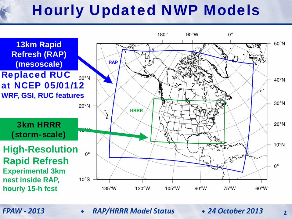
13km Rapid Refresh (RAP) (mesoscale)
3km HRRR (storm-scale)
High-Resolution Rapid Refresh Experimental 3km nest inside RAP, hourly 15-h fcst
Replaced RUC at NCEP 05/01/12 WRF, GSI, RUC features
Hourly Updated NWP Models
FPAW - 2013 24 October 2013 RAP/HRRR Model Status 2
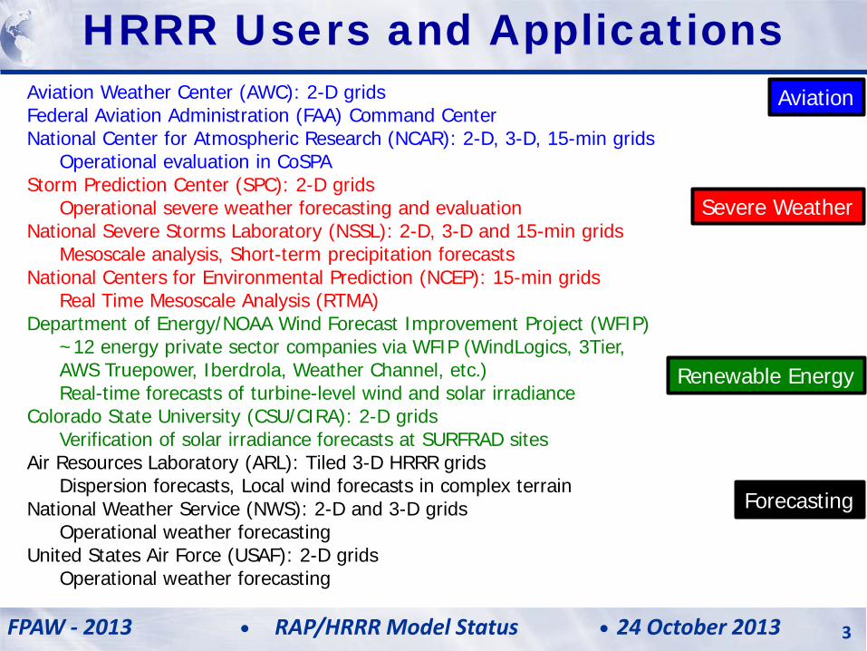
Aviation Weather Center (AWC): 2-D grids Federal Aviation Administration (FAA) Command Center National Center for Atmospheric Research (NCAR): 2-D, 3-D, 15-min grids Operational evaluation in CoSPA Storm Prediction Center (SPC): 2-D grids Operational severe weather forecasting and evaluation National Severe Storms Laboratory (NSSL): 2-D, 3-D and 15-min grids Mesoscale analysis, Short-term precipitation forecasts National Centers for Environmental Prediction (NCEP): 15-min grids Real Time Mesoscale Analysis (RTMA) Department of Energy/NOAA Wind Forecast Improvement Project (WFIP) ~12 energy private sector companies via WFIP (WindLogics, 3Tier, AWS Truepower, Iberdrola, Weather Channel, etc.) Real-time forecasts of turbine-level wind and solar irradiance Colorado State University (CSU/CIRA): 2-D grids Verification of solar irradiance forecasts at SURFRAD sites Air Resources Laboratory (ARL): Tiled 3-D HRRR grids Dispersion forecasts, Local wind forecasts in complex terrain National Weather Service (NWS): 2-D and 3-D grids Operational weather forecasting United States Air Force (USAF): 2-D grids Operational weather forecasting
Severe Weather
Aviation
Renewable Energy
Forecasting
HRRR Users and Applications
FPAW - 2013 24 October 2013 RAP/HRRR Model Status 3
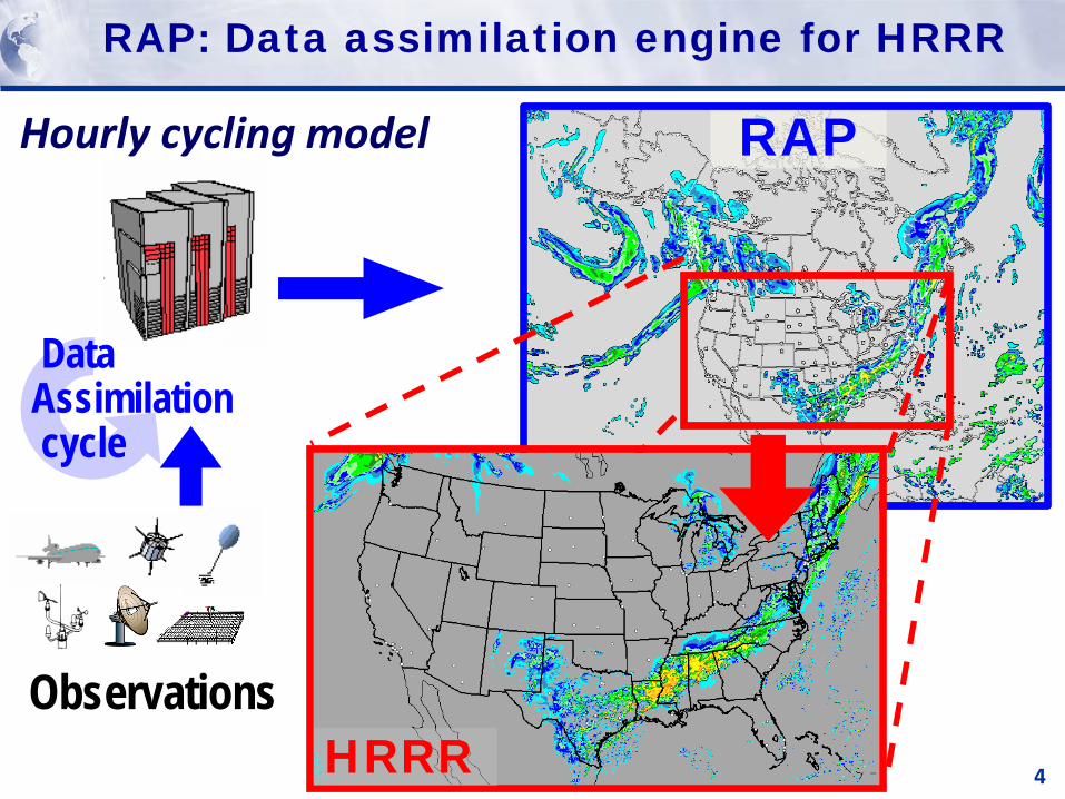
RAP: Data assimilation engine for HRRR
4
RAP
Data Assimilation cycle
Observations
Hourly cycling model
HRRR
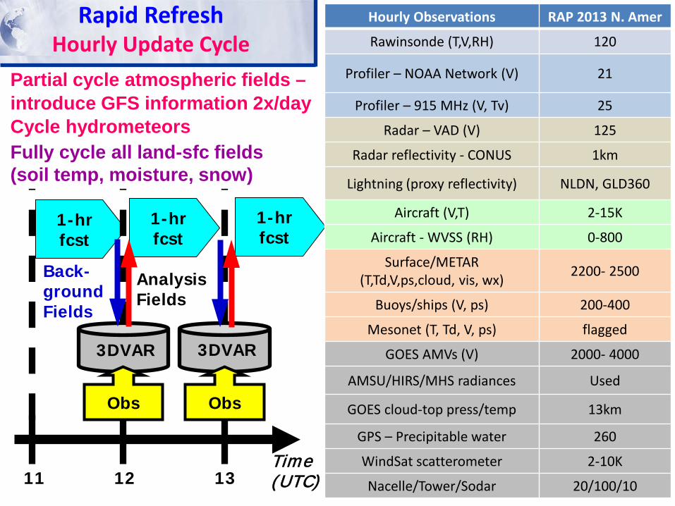
Rapid Refresh Hourly Update Cycle
1-hr fcst
1-hr fcst
1-hr fcst
11 12 13 Time (UTC)
Analysis Fields
3DVAR
Obs
3DVAR
Obs
Back- ground Fields
Partial cycle atmospheric fields – introduce GFS information 2x/day Cycle hydrometeors Fully cycle all land-sfc fields (soil temp, moisture, snow)
Hourly Observations RAP 2013 N. Amer
Rawinsonde (T,V,RH) 120
Profiler – NOAA Network (V) 21
Profiler – 915 MHz (V, Tv) 25
Radar – VAD (V) 125
Radar reflectivity - CONUS 1km
Lightning (proxy reflectivity) NLDN, GLD360
Aircraft (V,T) 2-15K
Aircraft - WVSS (RH) 0-800
Surface/METAR (T,Td,V,ps,cloud, vis, wx) 2200- 2500
Buoys/ships (V, ps) 200-400
Mesonet (T, Td, V, ps) flagged
GOES AMVs (V) 2000- 4000
AMSU/HIRS/MHS radiances Used
GOES cloud-top press/temp 13km
GPS – Precipitable water 260
WindSat scatterometer 2-10K
Nacelle/Tower/Sodar 20/100/10
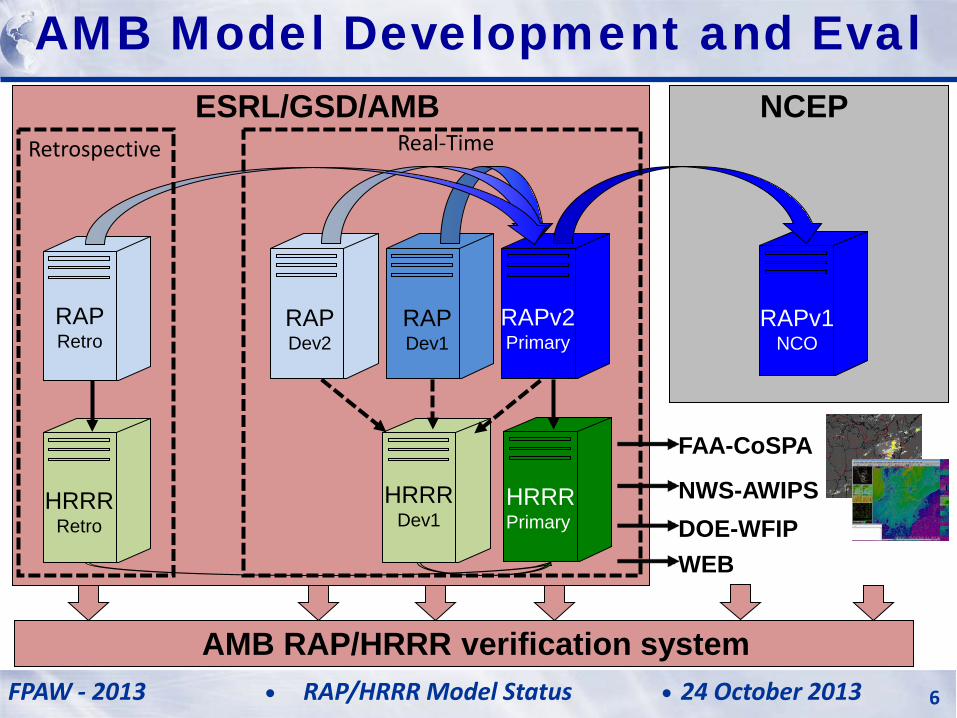
HRRR Primary
FAA-CoSPA
NCEP ESRL/GSD/AMB
RAP Dev1
RAPv2 Primary
HRRR Dev1
RAPv1 NCO
RAP Dev2
RAP Retro
HRRR Retro
Retrospective Real-Time
HRRR (and RAP) Future Milestones HRRR Milestones
AMB RAP/HRRR verification system
DOE-WFIP NWS-AWIPS
WEB
AMB Model Development and Eval
FPAW - 2013 24 October 2013 RAP/HRRR Model Status 6
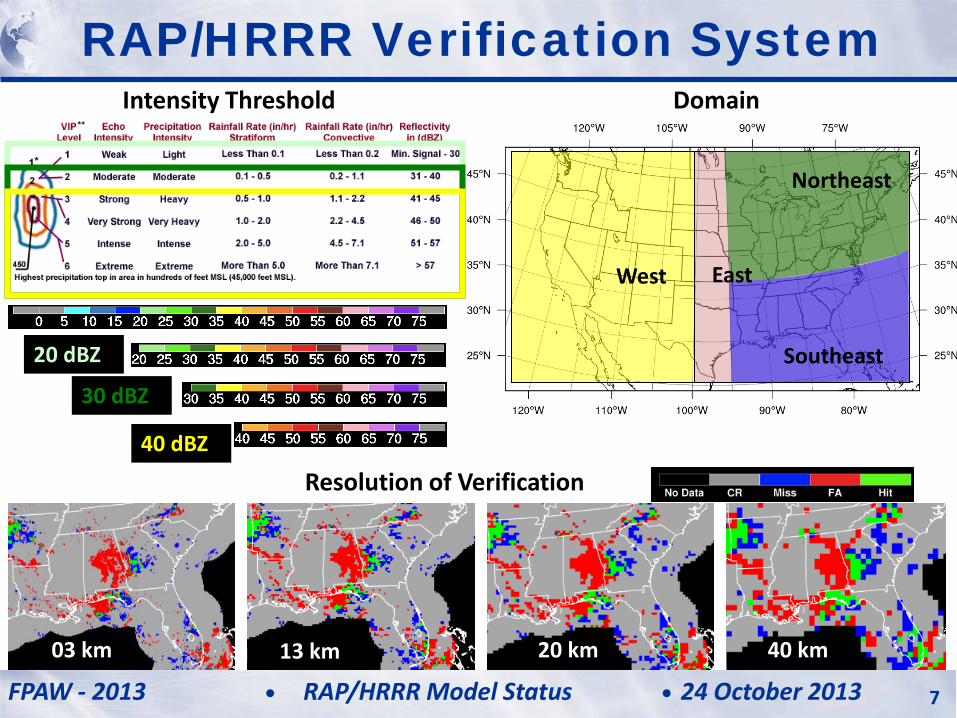
Intensity Threshold Domain
40 dBZ
Northeast
Southeast
East West
20 dBZ
30 dBZ
Resolution of Verification
03 km 13 km 20 km 40 km
RAP/HRRR Verification System
FPAW - 2013 24 October 2013 RAP/HRRR Model Status 7
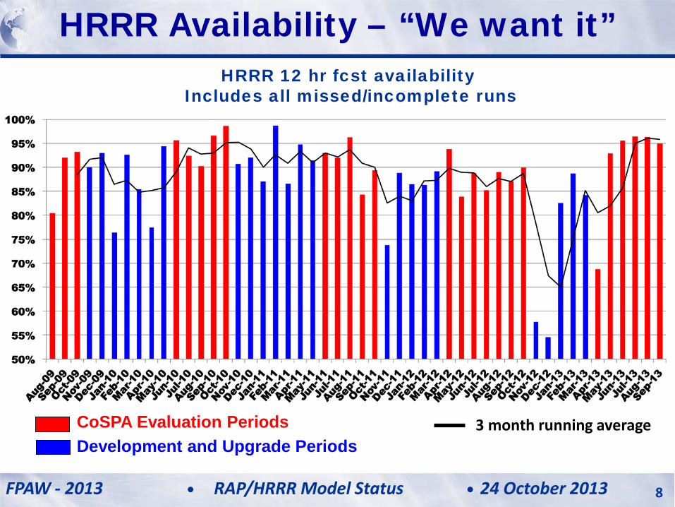
HRRR 12 hr fcst availability Includes all missed/incomplete runs
HRRR (and RAP) Future Milestones HRRR Milestones HRRR Availability – “We want it”
CoSPA Evaluation Periods Development and Upgrade Periods
3 month running average
FPAW - 2013 24 October 2013 RAP/HRRR Model Status 8
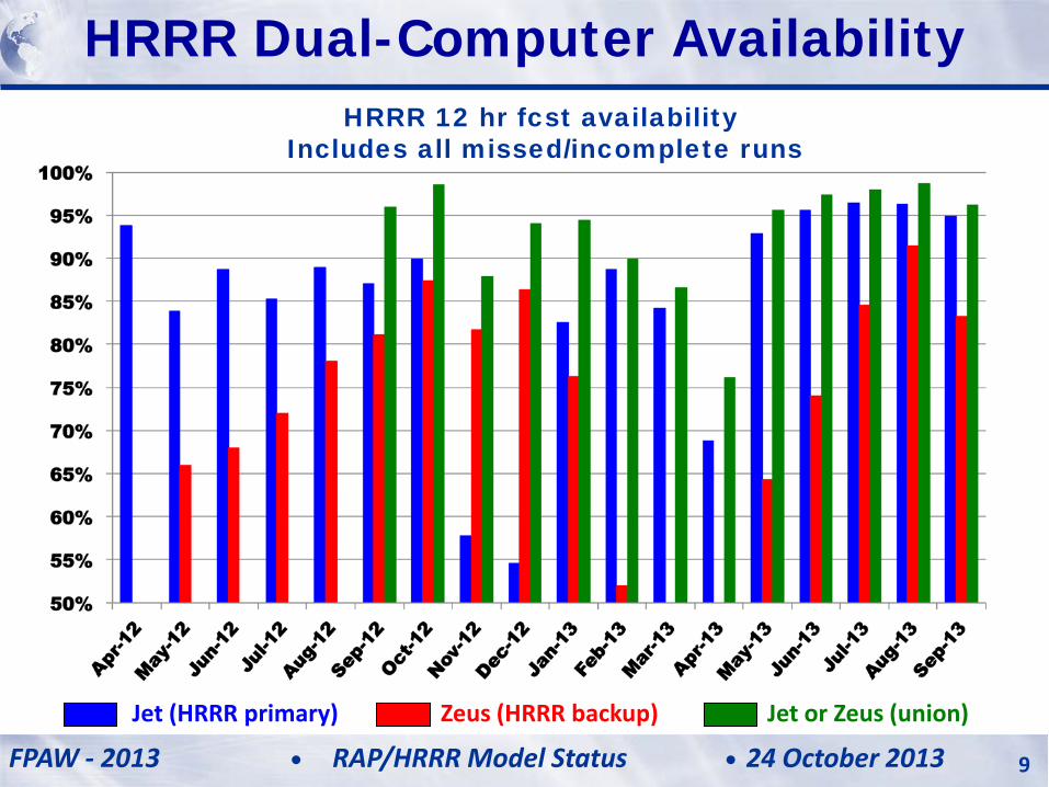
Jet or Zeus (union)
HRRR 12 hr fcst availability Includes all missed/incomplete runs
Jet (HRRR primary) Zeus (HRRR backup)
HRRR (and RAP) Future Milestones HRRR Milestones HRRR Dual-Computer Availability
FPAW - 2013 24 October 2013 RAP/HRRR Model Status 9
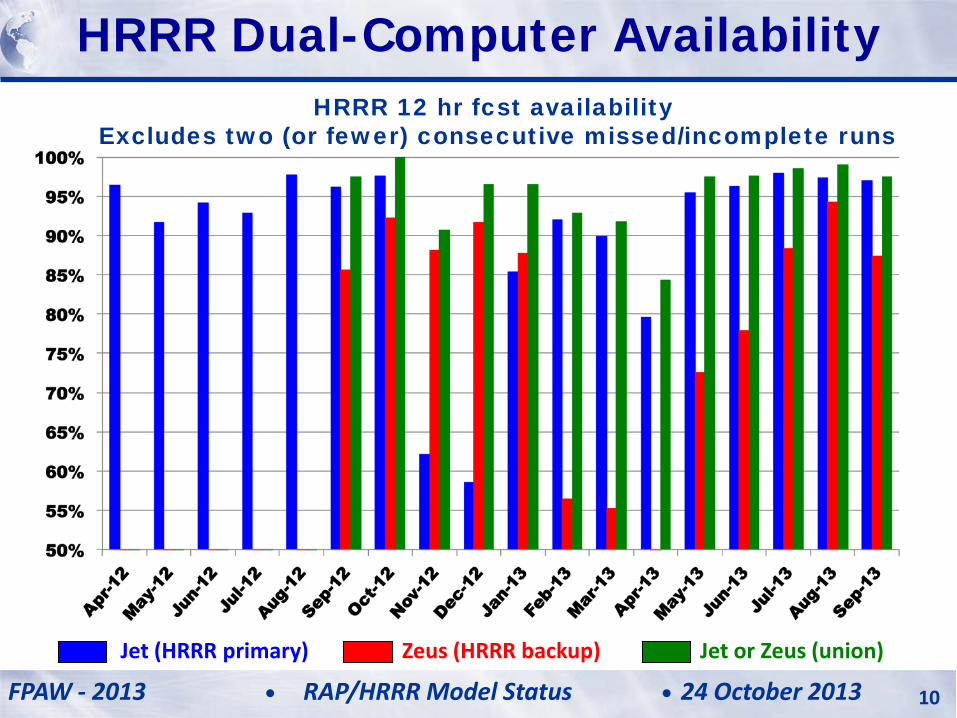
Jet or Zeus (union) Jet (HRRR primary) Zeus (HRRR backup)
HRRR 12 hr fcst availability Excludes two (or fewer) consecutive missed/incomplete runs
HRRR (and RAP) Future Milestones HRRR Milestones HRRR Dual-Computer Availability
FPAW - 2013 24 October 2013 RAP/HRRR Model Status 10
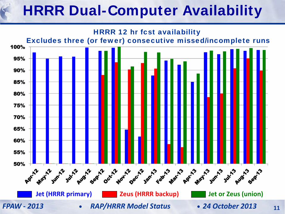
Jet or Zeus (union) Jet (HRRR primary) Zeus (HRRR backup)
HRRR 12 hr fcst availability Excludes three (or fewer) consecutive missed/incomplete runs
HRRR (and RAP) Future Milestones HRRR Milestones HRRR Dual-Computer Availability
FPAW - 2013 24 October 2013 RAP/HRRR Model Status 11
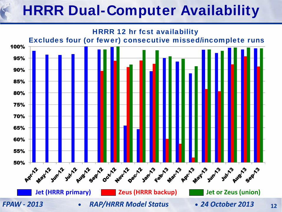
Jet or Zeus (union) Jet (HRRR primary) Zeus (HRRR backup)
HRRR 12 hr fcst availability Excludes four (or fewer) consecutive missed/incomplete runs
HRRR (and RAP) Future Milestones HRRR Milestones HRRR Dual-Computer Availability
FPAW - 2013 24 October 2013 RAP/HRRR Model Status 12
HRRR (and RAP) Future Milestones HRRR Milestones
CoSPA Evaluation Periods Development and Upgrade Periods
3 month running average
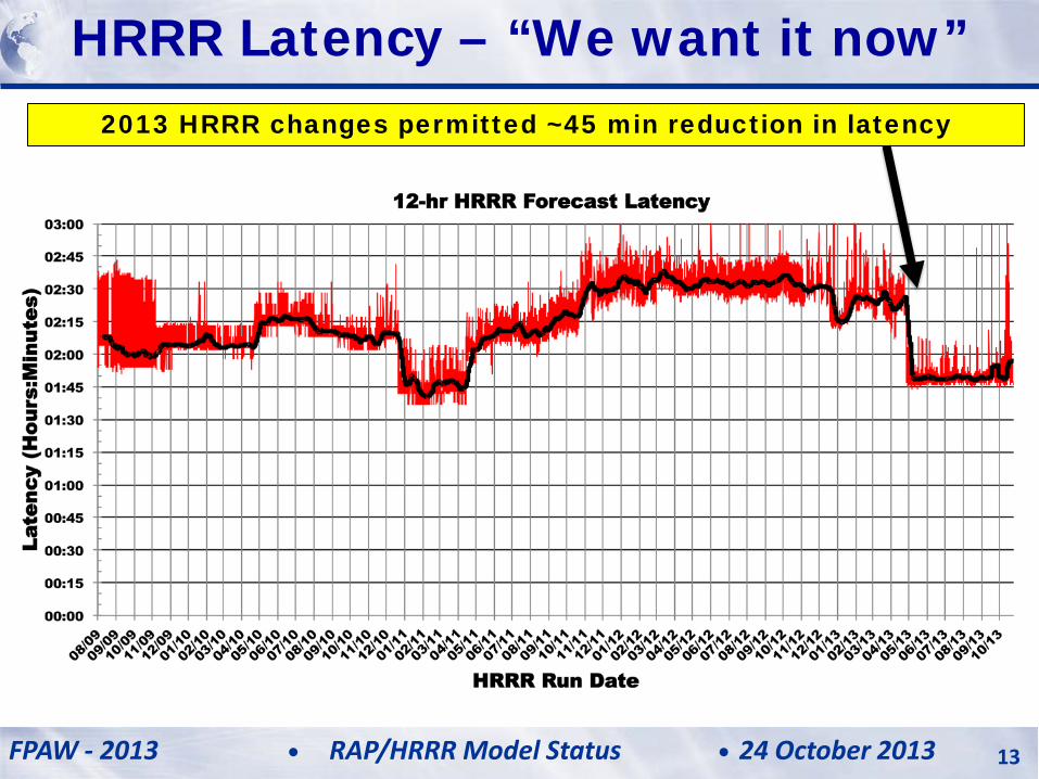
HRRR Latency – “We want it now”
FPAW - 2013 24 October 2013 RAP/HRRR Model Status 13
2013 HRRR changes permitted ~45 min reduction in latency
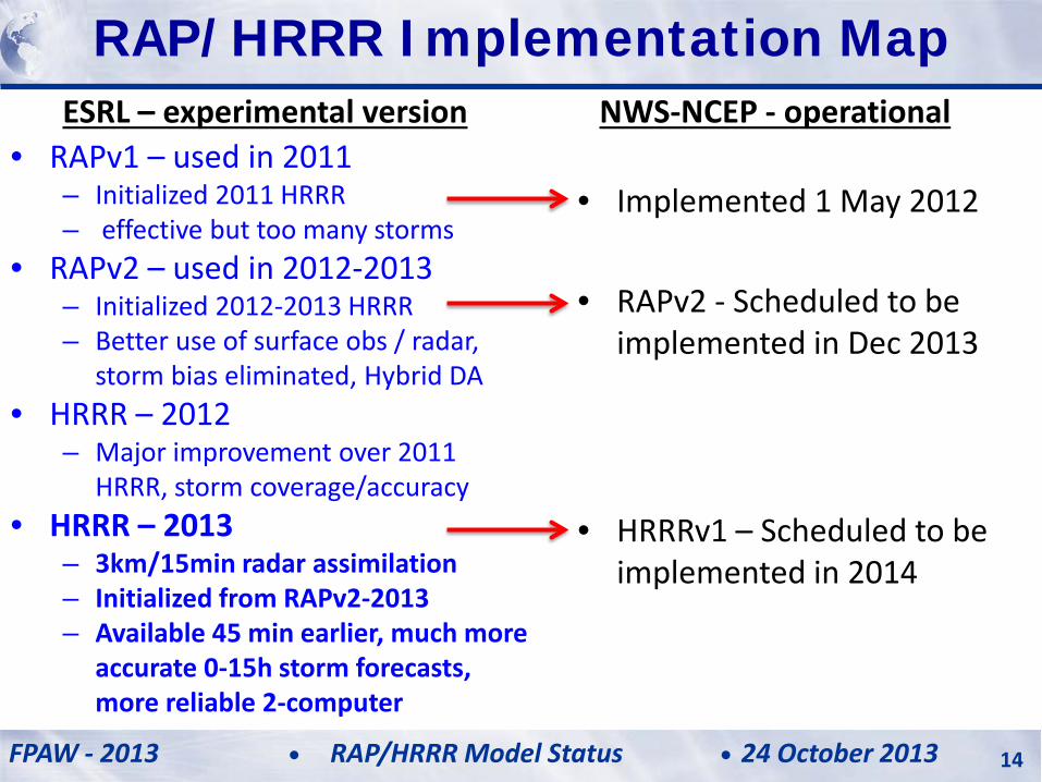
ESRL – experimental version • RAPv1 – used in 2011
– Initialized 2011 HRRR – effective but too many storms
• RAPv2 – used in 2012-2013 – Initialized 2012-2013 HRRR – Better use of surface obs / radar,
storm bias eliminated, Hybrid DA • HRRR – 2012
– Major improvement over 2011 HRRR, storm coverage/accuracy
• HRRR – 2013 – 3km/15min radar assimilation – Initialized from RAPv2-2013 – Available 45 min earlier, much more
accurate 0-15h storm forecasts, more reliable 2-computer
NWS-NCEP - operational
• Implemented 1 May 2012 • RAPv2 - Scheduled to be
implemented in Dec 2013
• HRRRv1 – Scheduled to be implemented in 2014
HRRR (and RAP) Future Milestones HRRR Milestones RAP/HRRR Implementation Map
FPAW - 2013 24 October 2013 RAP/HRRR Model Status 14
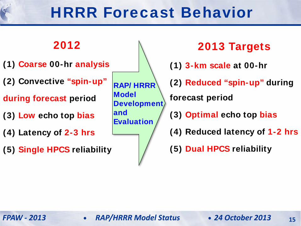
HRRR Forecast Behavior
2013 Targets
(1) 3-km scale at 00-hr
(2) Reduced “spin-up” during
forecast period
(3) Optimal echo top bias
(4) Reduced latency of 1-2 hrs
(5) Dual HPCS reliability
RAP/HRRR Model Development and Evaluation
2012
(1) Coarse 00-hr analysis
(2) Convective “spin-up”
during forecast period
(3) Low echo top bias
(4) Latency of 2-3 hrs
(5) Single HPCS reliability
FPAW - 2013 24 October 2013 RAP/HRRR Model Status 15
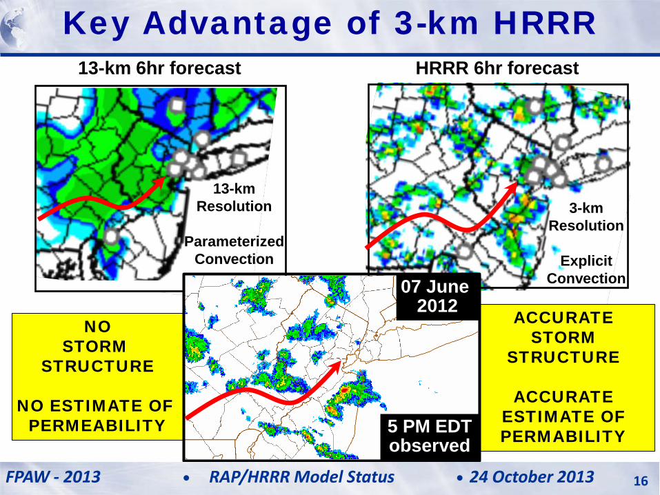
13-km 6hr forecast HRRR 6hr forecast
13-km Resolution
Parameterized
Convection
3-km Resolution
Explicit
Convection
HRRR (and RAP) Future Milestones HRRR Milestones Key Advantage of 3-km HRRR
ACCURATE STORM
STRUCTURE
ACCURATE ESTIMATE OF PERMABILITY
NO STORM
STRUCTURE
NO ESTIMATE OF PERMEABILITY
07 June 2012
5 PM EDT observed
FPAW - 2013 24 October 2013 RAP/HRRR Model Status 16
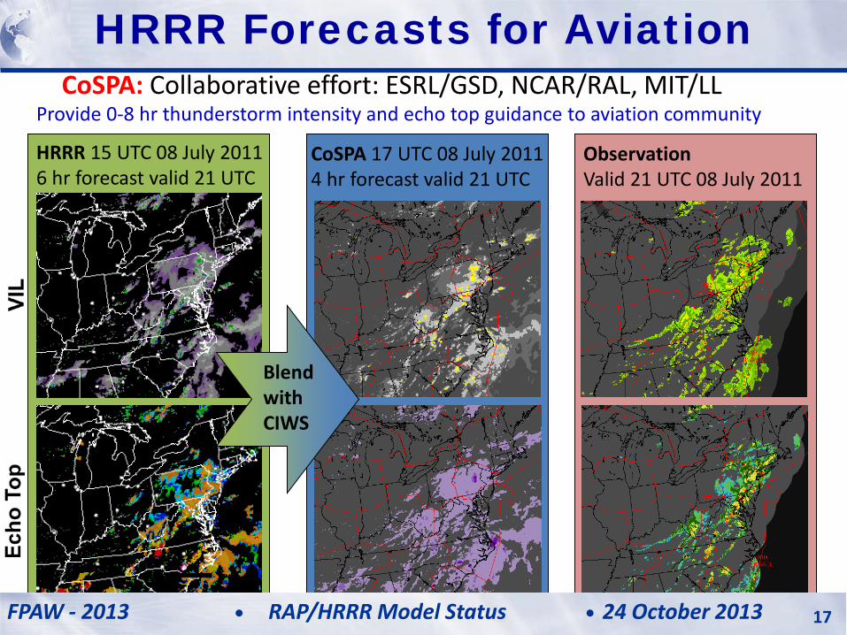
CoSPA: Collaborative effort: ESRL/GSD, NCAR/RAL, MIT/LL
Provide 0-8 hr thunderstorm intensity and echo top guidance to aviation community
HRRR 15 UTC 08 July 2011 6 hr forecast valid 21 UTC
CoSPA 17 UTC 08 July 2011 4 hr forecast valid 21 UTC
Observation Valid 21 UTC 08 July 2011
Blend with CIWS
HRRR (and RAP) Future Milestones HRRR Milestones HRRR Forecasts for Aviation
FPAW - 2013 24 October 2013 RAP/HRRR Model Status 17
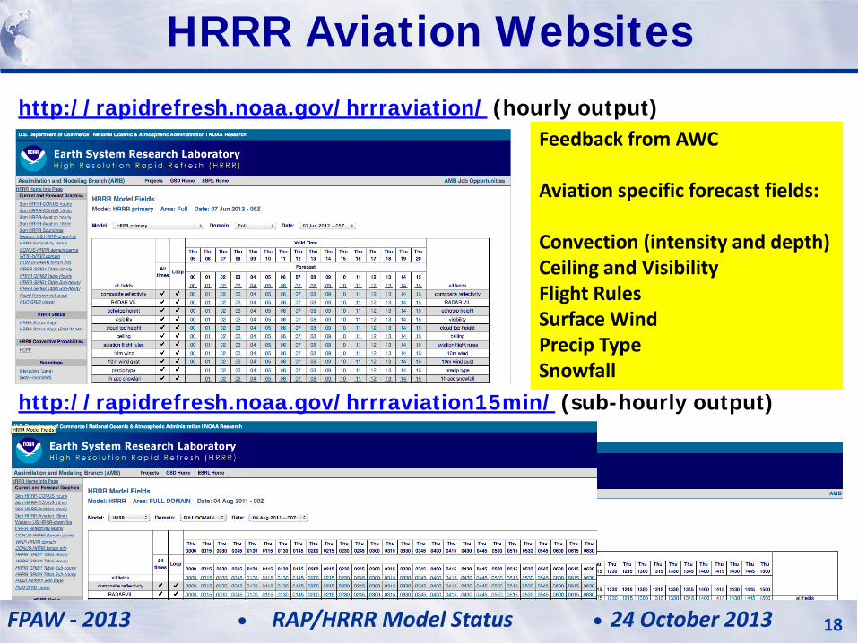
http://rapidrefresh.noaa.gov/hrrraviation/ (hourly output) Feedback from AWC Aviation specific forecast fields: Convection (intensity and depth) Ceiling and Visibility Flight Rules Surface Wind Precip Type Snowfall
http://rapidrefresh.noaa.gov/hrrraviation15min/ (sub-hourly output)
HRRR (and RAP) Future Milestones HRRR Milestones HRRR Aviation Websites
FPAW - 2013 24 October 2013 RAP/HRRR Model Status 18
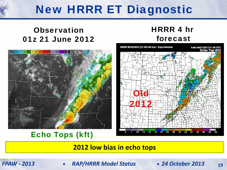
HRRR 4 hr forecast
Observation 01z 21 June 2012
Old 2012
Echo Tops (kft)
New HRRR ET Diagnostic
2012 low bias in echo tops
FPAW - 2013 24 October 2013 RAP/HRRR Model Status 19
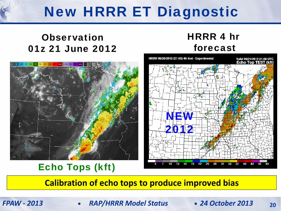
NEW 2012
New HRRR ET Diagnostic HRRR 4 hr
forecast Observation
01z 21 June 2012
Echo Tops (kft) Calibration of echo tops to produce improved bias
FPAW - 2013 24 October 2013 RAP/HRRR Model Status 20
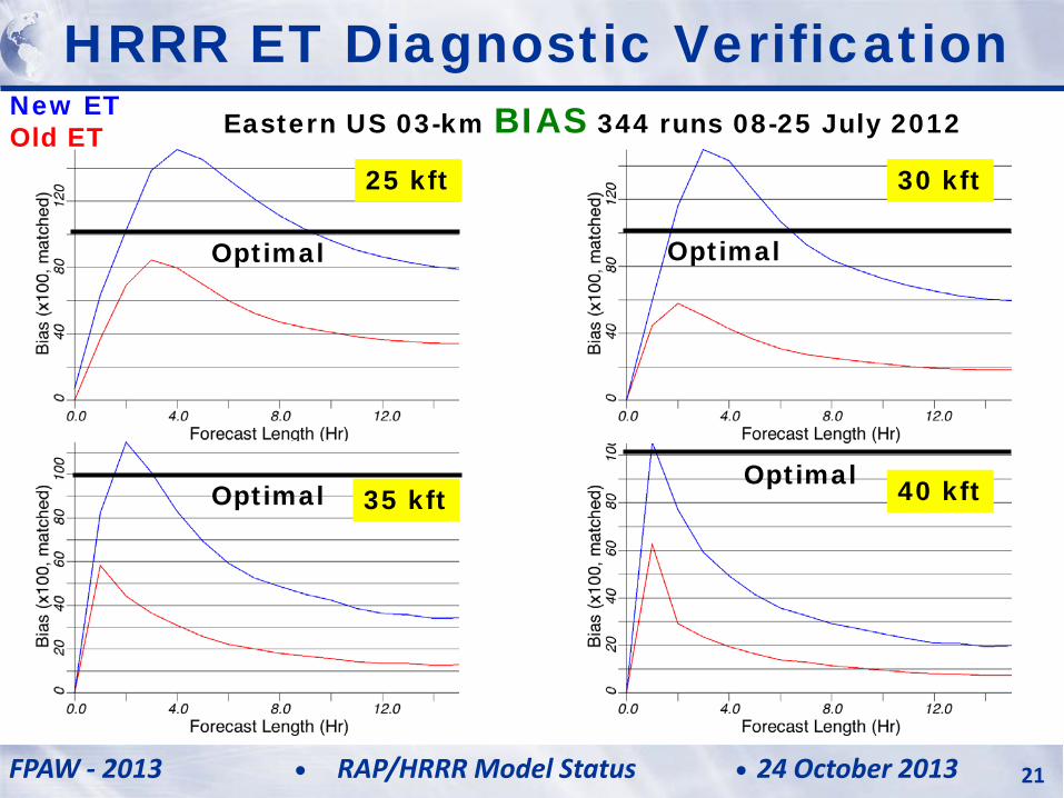
HRRR ET Diagnostic Verification Eastern US 03-km BIAS 344 runs 08-25 July 2012
25 kft 30 kft
35 kft 40 kft
Optimal Optimal
Optimal Optimal
New ET Old ET
FPAW - 2013 24 October 2013 RAP/HRRR Model Status 21
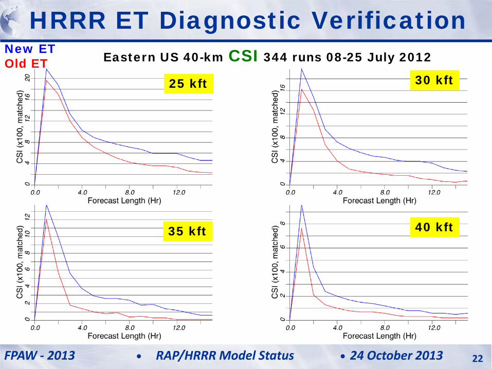
HRRR ET Diagnostic Verification Eastern US 40-km CSI 344 runs 08-25 July 2012
25 kft 30 kft
35 kft 40 kft
New ET Old ET
FPAW - 2013 24 October 2013 RAP/HRRR Model Status 22
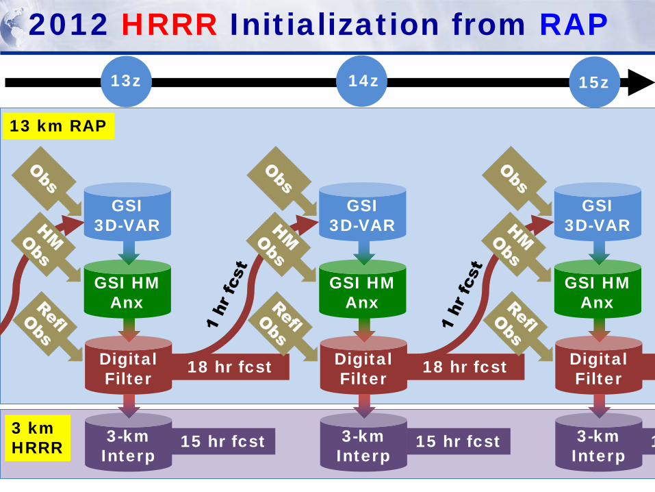
3-km Interp
2012 HRRR Initialization from RAP
GSI 3D-VAR
GSI HM Anx
Digital Filter
18 hr fcst
15 hr fcst 3-km Interp
GSI 3D-VAR
GSI HM Anx
Digital Filter
18 hr fcst
15 hr fcst 3-km Interp
GSI 3D-VAR
GSI HM Anx
Digital Filter
1
13 km RAP
3 km HRRR
13z 14z 15z
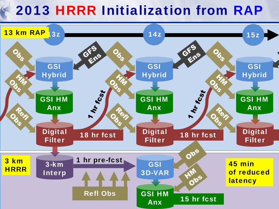
3-km Interp
2013 HRRR Initialization from RAP
GSI Hybrid
GSI HM Anx
Digital Filter
18 hr fcst
GSI Hybrid
GSI HM Anx
Digital Filter
18 hr fcst
GSI Hybrid
GSI HM Anx
Digital Filter
3 km HRRR
13z 14z 15z 13 km RAP
Refl Obs
1 hr pre-fcst
GSI HM Anx
GSI 3D-VAR
15 hr fcst
45 min of reduced latency
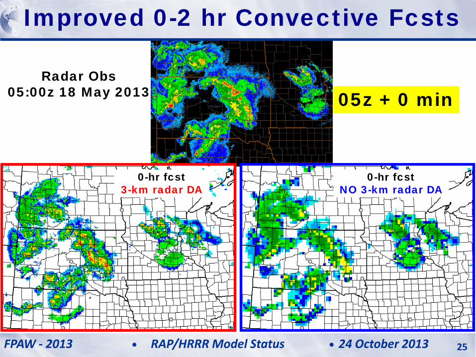
Radar Obs 05:00z 18 May 2013
0-hr fcst 3-km radar DA
0-hr fcst NO 3-km radar DA
Improved 0-2 hr Convective Fcsts
05z + 0 min
FPAW - 2013 24 October 2013 RAP/HRRR Model Status 25
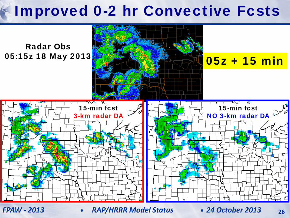
Radar Obs 05:15z 18 May 2013
Improved 0-2 hr Convective Fcsts
05z + 15 min
15-min fcst 3-km radar DA
15-min fcst NO 3-km radar DA
FPAW - 2013 24 October 2013 RAP/HRRR Model Status 26
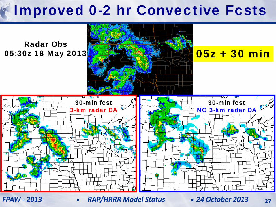
Radar Obs 05:30z 18 May 2013
Improved 0-2 hr Convective Fcsts
05z + 30 min
30-min fcst 3-km radar DA
30-min fcst NO 3-km radar DA
FPAW - 2013 24 October 2013 RAP/HRRR Model Status 27
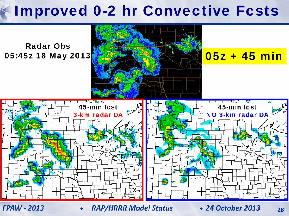
Radar Obs 05:45z 18 May 2013
Improved 0-2 hr Convective Fcsts
05z + 45 min
45-min fcst 3-km radar DA
45-min fcst NO 3-km radar DA
FPAW - 2013 24 October 2013 RAP/HRRR Model Status 28
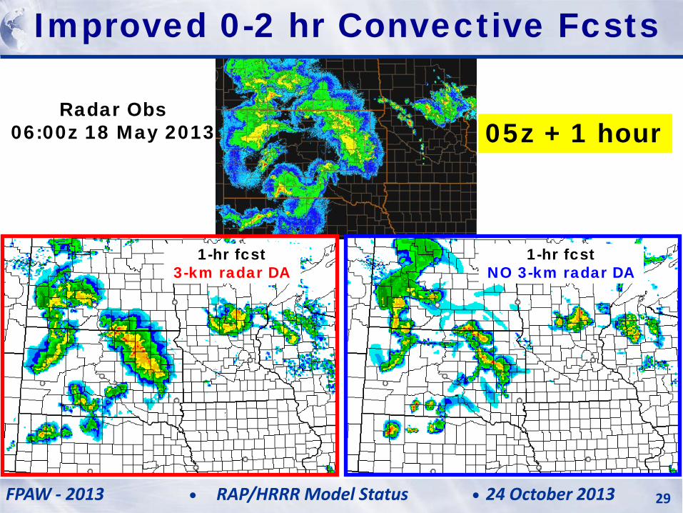
Radar Obs 06:00z 18 May 2013
Improved 0-2 hr Convective Fcsts
05z + 1 hour
1-hr fcst 3-km radar DA
1-hr fcst NO 3-km radar DA
FPAW - 2013 24 October 2013 RAP/HRRR Model Status 29
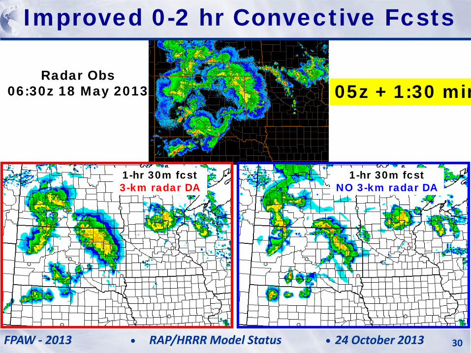
Radar Obs 06:30z 18 May 2013
Improved 0-2 hr Convective Fcsts
05z + 1:30 min
1-hr 30m fcst 3-km radar DA
1-hr 30m fcst NO 3-km radar DA
FPAW - 2013 24 October 2013 RAP/HRRR Model Status 30
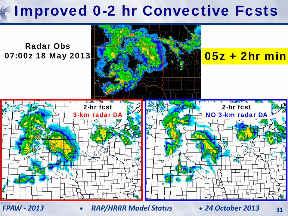
Radar Obs 07:00z 18 May 2013
Improved 0-2 hr Convective Fcsts
05z + 2hr min
2-hr fcst 3-km radar DA
2-hr fcst NO 3-km radar DA
FPAW - 2013 24 October 2013 RAP/HRRR Model Status 31
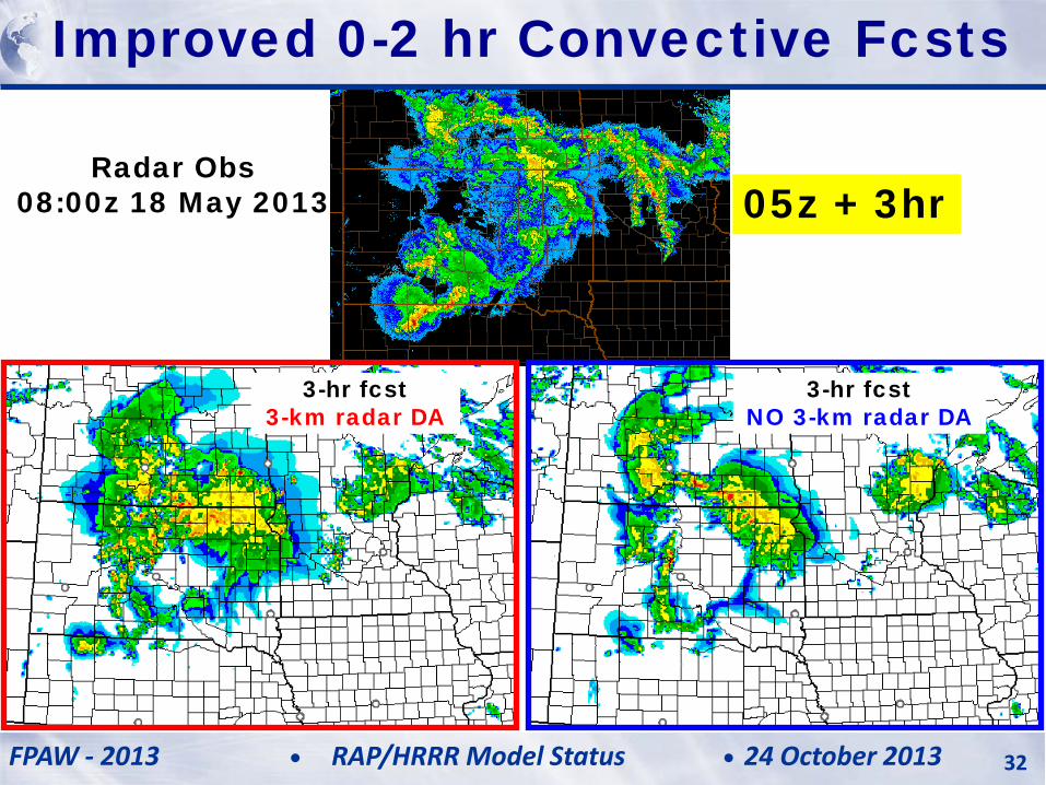
Radar Obs 08:00z 18 May 2013
Improved 0-2 hr Convective Fcsts
05z + 3hr
3-hr fcst 3-km radar DA
3-hr fcst NO 3-km radar DA
FPAW - 2013 24 October 2013 RAP/HRRR Model Status 32
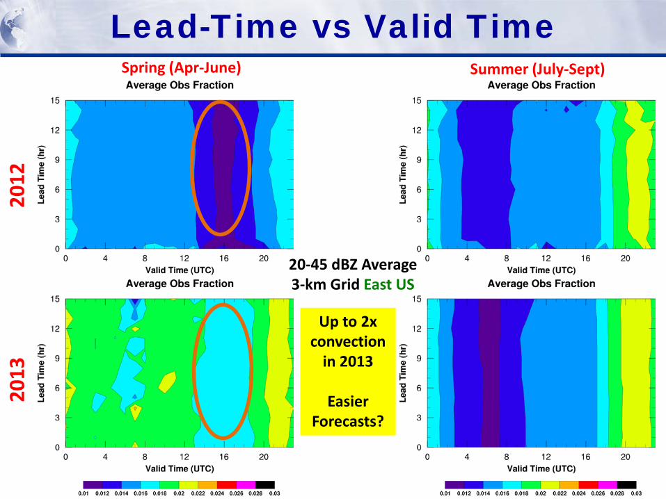
Lead-Time vs Valid Time Spring (Apr-June) Summer (July-Sept)
20-45 dBZ Average 3-km Grid East US
Up to 2x convection
in 2013
Easier Forecasts?
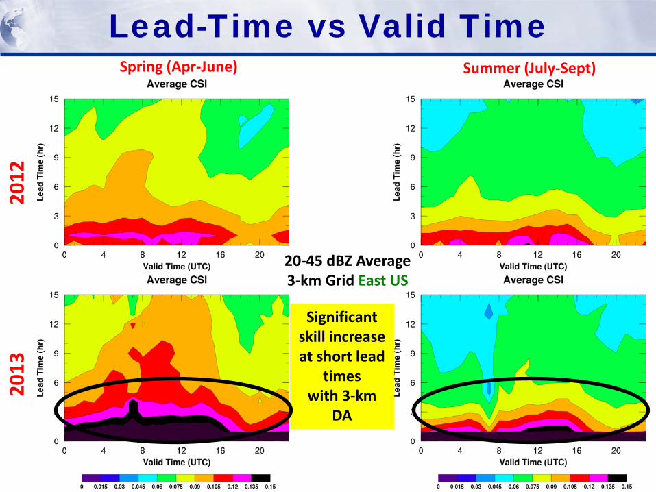
Lead-Time vs Valid Time Spring (Apr-June) Summer (July-Sept)
20-45 dBZ Average 3-km Grid East US
Significant skill increase at short lead
times with 3-km
DA
Lead-Time vs Valid Time Spring (Apr-June) Summer (July-Sept)
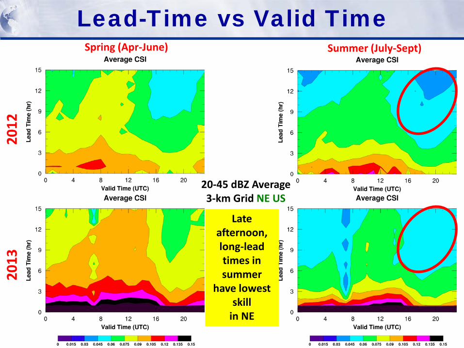
20-45 dBZ Average 3-km Grid NE US
Late afternoon, long-lead times in summer
have lowest skill
in NE
Lead-Time vs Valid Time Spring (Apr-June) Summer (July-Sept)
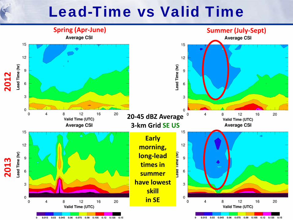
20-45 dBZ Average 3-km Grid SE US
Early morning, long-lead times in summer
have lowest skill in SE
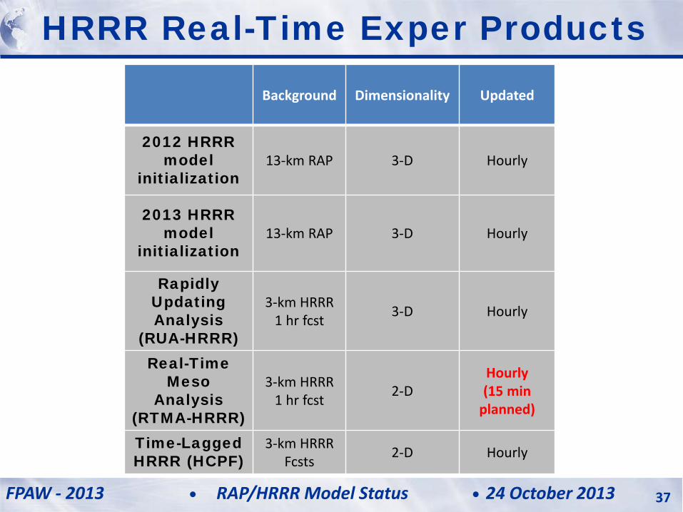
Background Dimensionality Updated
2012 HRRR model
initialization 13-km RAP 3-D Hourly
2013 HRRR model
initialization 13-km RAP 3-D Hourly
Rapidly Updating Analysis
(RUA-HRRR)
3-km HRRR 1 hr fcst 3-D Hourly
Real-Time Meso
Analysis (RTMA-HRRR)
3-km HRRR 1 hr fcst 2-D
Hourly (15 min
planned)
Time-Lagged HRRR (HCPF)
3-km HRRR Fcsts 2-D Hourly
HRRR Real-Time Exper Products
FPAW - 2013 24 October 2013 RAP/HRRR Model Status 37
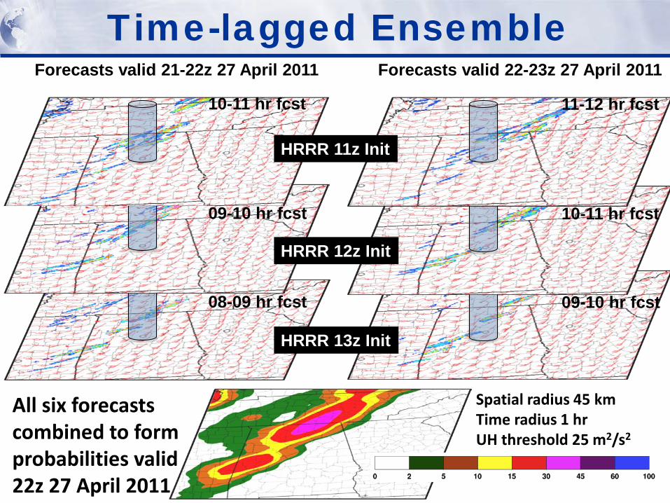
10-11 hr fcst
09-10 hr fcst
08-09 hr fcst
11-12 hr fcst
10-11 hr fcst
09-10 hr fcst
Forecasts valid 21-22z 27 April 2011 Forecasts valid 22-23z 27 April 2011
All six forecasts combined to form probabilities valid 22z 27 April 2011
HRRR 11z Init
HRRR 12z Init
HRRR 13z Init
Time-lagged Ensemble
Spatial radius 45 km Time radius 1 hr UH threshold 25 m2/s2
FPAW - 2013 24 October 2013 RAP/HRRR Model Status 39
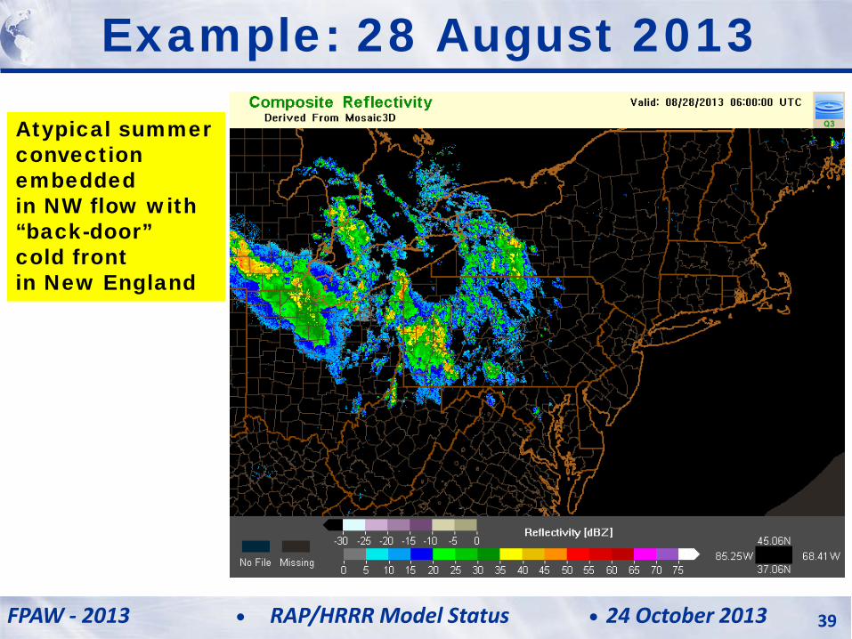
Example: 28 August 2013
Atypical summer convection embedded in NW flow with “back-door” cold front in New England
FPAW - 2013 24 October 2013 RAP/HRRR Model Status 40
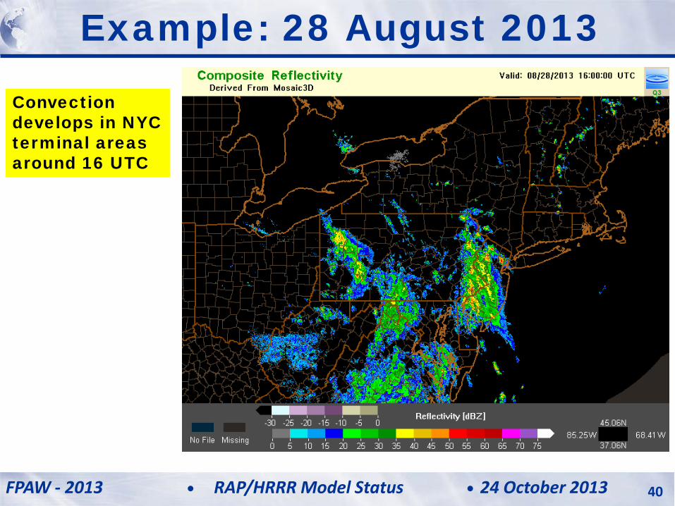
Example: 28 August 2013
Convection develops in NYC terminal areas around 16 UTC
FPAW - 2013 24 October 2013 RAP/HRRR Model Status 41
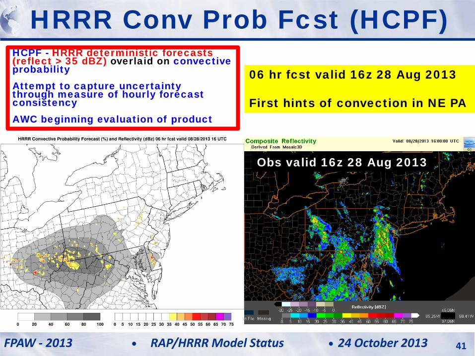
HCPF - HRRR deterministic forecasts (reflect > 35 dBZ) overlaid on convective probability Attempt to capture uncertainty through measure of hourly forecast consistency AWC beginning evaluation of product
HRRR Conv Prob Fcst (HCPF)
06 hr fcst valid 16z 28 Aug 2013 First hints of convection in NE PA
Obs valid 16z 28 Aug 2013
FPAW - 2013 24 October 2013 RAP/HRRR Model Status 42
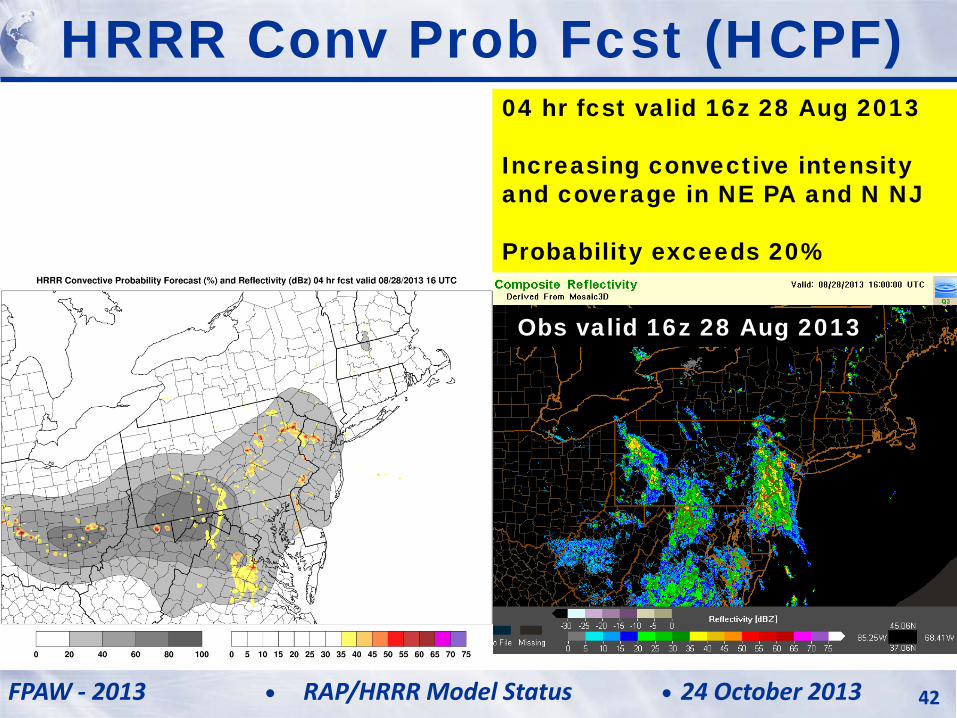
Obs valid 16z 28 Aug 2013
04 hr fcst valid 16z 28 Aug 2013 Increasing convective intensity and coverage in NE PA and N NJ Probability exceeds 20%
HRRR Conv Prob Fcst (HCPF)
FPAW - 2013 24 October 2013 RAP/HRRR Model Status 43
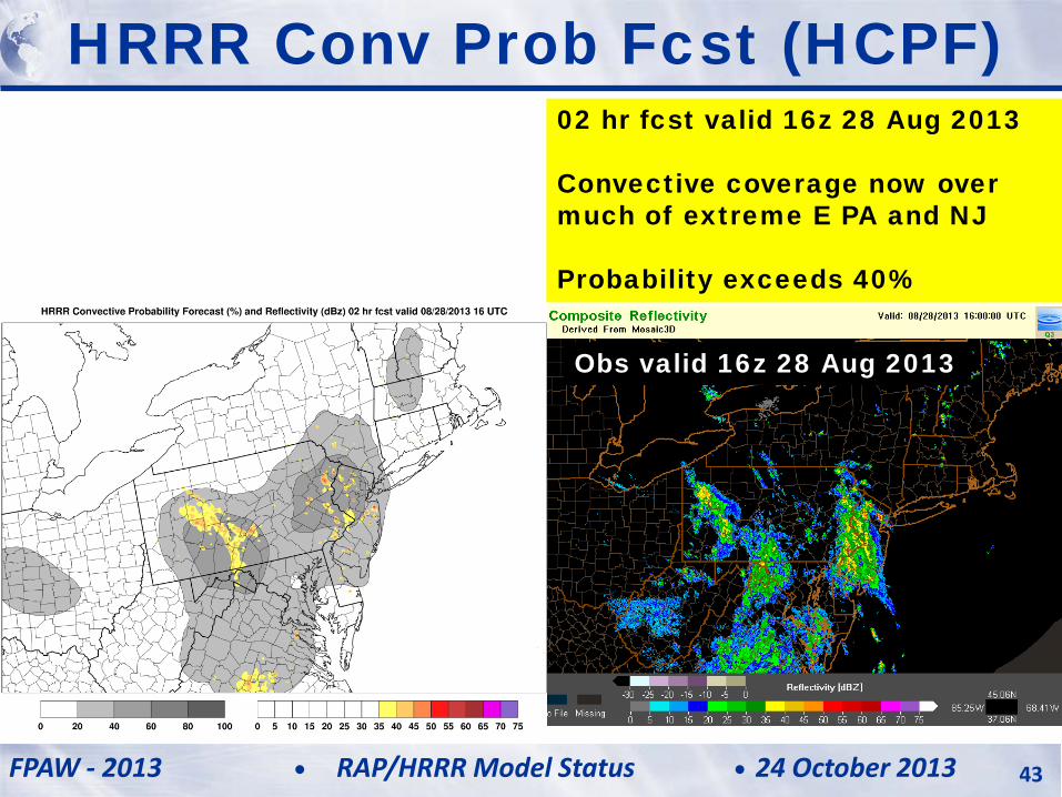
Obs valid 16z 28 Aug 2013
HRRR Conv Prob Fcst (HCPF) 02 hr fcst valid 16z 28 Aug 2013 Convective coverage now over much of extreme E PA and NJ Probability exceeds 40%

FPAW - 2013 24 October 2013 RAP/HRRR Model Status 44
Obs valid 16z 28 Aug 2013
Analysis valid 16z 28 Aug 2013 Probability exceeds 60% with centroid west of NYC
HRRR Conv Prob Fcst (HCPF)
FPAW - 2013 24 October 2013 RAP/HRRR Model Status 45
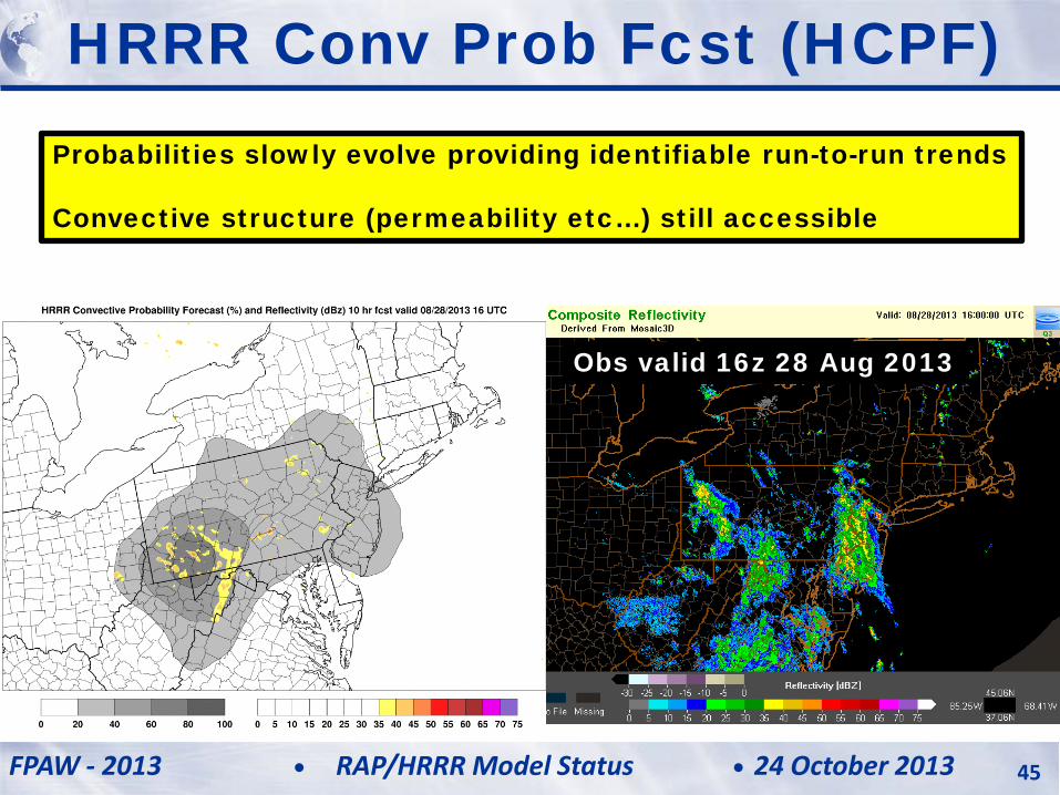
Obs valid 16z 28 Aug 2013
HRRR Conv Prob Fcst (HCPF) Probabilities slowly evolve providing identifiable run-to-run trends Convective structure (permeability etc…) still accessible
FPAW - 2013 24 October 2013 RAP/HRRR Model Status 46
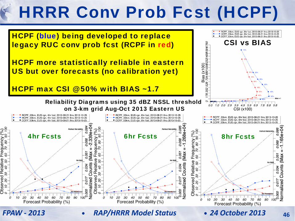
HRRR Conv Prob Fcst (HCPF) HCPF (blue) being developed to replace legacy RUC conv prob fcst (RCPF in red) HCPF more statistically reliable in eastern US but over forecasts (no calibration yet) HCPF max CSI @ 50% with BIAS ~1.7
Reliability Diagrams using 35 dBZ NSSL threshold on 3-km grid Aug-Oct 2013 Eastern US
4hr Fcsts 6hr Fcsts 8hr Fcsts
CSI vs BIAS
• Moist bias reduced in 2012 RAP and HRRR – Reduced false alarms, lower precipitation bias – GSI enhancements and WRF upgrade to v3.3.1 – Reflectivity diagnostic consistent with microphysics
• Science: Focus on 3-km assimilation for 2013 – 3-km variational analysis – 3-km non-variational cloud analysis – 3-km radar reflectivity data assimilation
• Technical: Reduced latency for 2013 (2-3 hrs now) – Approximate 1-hr reduction in execution time (1-2 hrs) – Faster post-processing with parallelization – Direct GRIB2 generation
Summary and Plans
FPAW - 2013 24 October 2013 RAP/HRRR Model Status 47
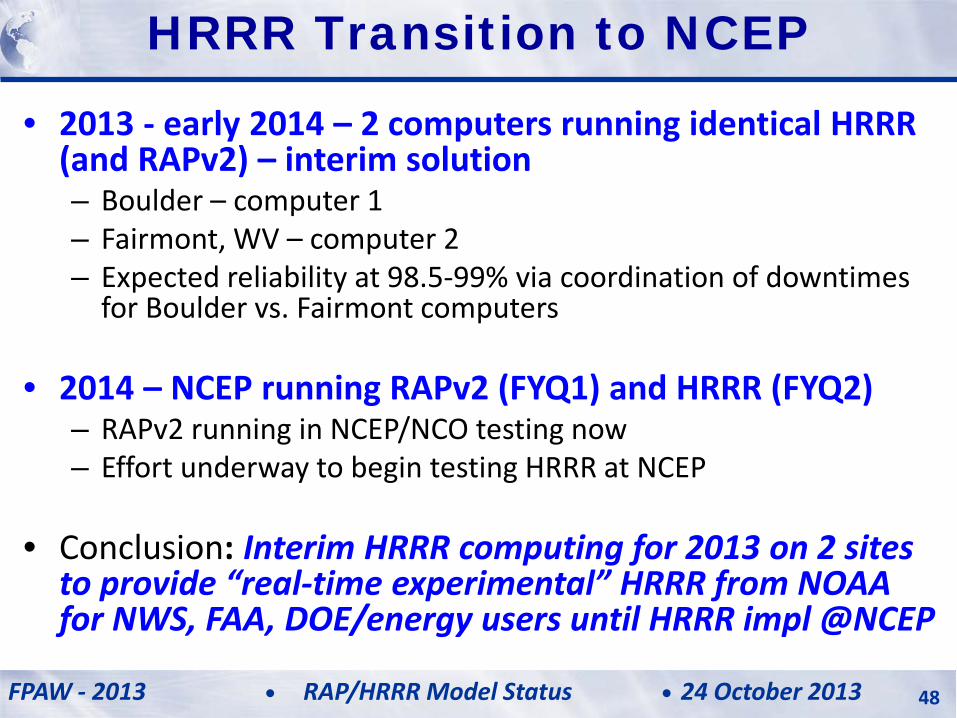
• 2013 - early 2014 – 2 computers running identical HRRR (and RAPv2) – interim solution – Boulder – computer 1 – Fairmont, WV – computer 2 – Expected reliability at 98.5-99% via coordination of downtimes
for Boulder vs. Fairmont computers
• 2014 – NCEP running RAPv2 (FYQ1) and HRRR (FYQ2) – RAPv2 running in NCEP/NCO testing now – Effort underway to begin testing HRRR at NCEP
• Conclusion: Interim HRRR computing for 2013 on 2 sites to provide “real-time experimental” HRRR from NOAA for NWS, FAA, DOE/energy users until HRRR impl @NCEP
HRRR Transition to NCEP
FPAW - 2013 24 October 2013 RAP/HRRR Model Status 48