Embed Size (px)
Citation preview

The NCEP Production Suite: Recent and Planned Upgrades
Michelle Mainelli presenting for:
Dr. William M. Lapenta Director, National Centers for Environmental Prediction NOAA/National Weather Service AMS Summer meeting July 2016, Tuscaloosa AL

Presentation Outline
2
• NWS and Weather Ready Nation
• The NCEP Production Suite
• Model Upgrades: GFS, RAP/HRRR, HWRF, NWM
• Recommended Long Term Plans to
Unify Suite

NWS Strategic Outcome:
Weather-Ready Nation
3
NWS Strategic Goals • Improve Weather Impact-Based Decision
Support Services
• Improve Water Forecasting Services
• Enhance Climate Services and adapt to climate-related risks
• Improve sector-relevant information in support of economic productivity
• Enable environmental forecast services supporting healthy communities and ecosystems
• Sustain a highly skilled, professional workforce equipped with training, tools, and infrastructure to meet mission
Operational numerical guidance:
Foundational tools to used to
improve public safety, quality of life
and make business decisions that
drive U.S. economic growth
Prediction is what makes NOAA/NWS unique and indispensable!

Seamless Suite of Operational
Numerical Guidance Systems
4
Forecast
Uncertainty
Minutes
Hours
Days
1 Week
2 Week
Months
Seasons
Years
Fo
recast
Lead
Tim
e
Warnings & Alert
Coordination
Watches
Forecasts
Threats
Assessments
Guidance
Outlook
Benefits
•North American Ensemble Forecast System
•Climate Forecast System
•Short-Range Ensemble
•Global Forecast System
•North American Mesoscale
•Rapid Refresh
•Dispersion (smoke)
•Global Ensemble Forecast System
• Waves • Global Ocean
• Space Weather
Spanning Weather and Climate
• NWM
• WAM
• Bays
•Global Dust
•Fire Wx
• Ozone
•Wave Ensemble •Land DA
• HRRR
•North American Multi-Model Ensemble System
• Tsunami • Nearshore Wave
• Regional Hurricane • Storm Surge

GFS/GDAS 4D Hybrid En-Var:
Implemented May 2016
5
4-D Hybrid En-Var:
All-sky AMSU-A Radiances
SATWND/Aircraft ob changes AVHRR satellite winds and aircraft moisture data are also
assimilated.
Modified relocation/tracking to allow
hourly relocation
Modified thinning/weight in time • Semi-implicit upgrade,
• Convective gravity wave
upgrade,
• Tracer adjustment upgrade
• Corrections to land surface
to reduce summertime warm,
dry bias over Great Plains
• Improved icing probability
products and new icing severity
product
• Hourly output through 120-hr
forecast
2m Dew Point RMSE 00Z Cycles 7 July to 11 Nov 2015

6
Hourly GFS Output to Day-5
04 June 2016, 12 UTC cycle; Hourly to 120 hours
GFS Colum Precipitable Water (kg/m2)
0.25° x 0.25°
Fcst Hour
http://nomads.ncep.noaa.gov/pub/data/nccf/com/gfs/prod/gfs
ftp://ftp.ncep.noaa.gov/pub/data/nccf/com/gfs/prod/gfs

High-Resolution Forecast Guidance
from HWRF for all global Tropical
Cyclones: Upgraded July 2016
Typhoon
Rammasun
Philippines
Typhoon
Phanfone Japan
Typhoon Usagi
China/Taiwan
Typhoon Neoguri
Korea/Japan
Twin Hurricanes
Iselle and Julio,
Hawaii
Typhoon Pam
Vanuatu Islands,
Southern
Hemisphere
Typhoon Bavi
Micronesian
Islands
Hurricane Sandy,
North Atlantic

RAP/ HRRR
Planned Upgrade Aug 2016
8
Hourly-Updated weather model guidance for improved decision-making
W
arm
C
oo
l
Jul-Aug 12 hr 2m Temp
Exper RAPv3
Oper RAPv2
Difference
Forecast Hours:
RAPv3 increasing
from F18 to F21
HRRRv2 increasing
from F15 to F18
Significant improvements: Better PBL, LSM, Microphysics, data assimilation
Benefits: Significantly reduced biases, reduced RMS, Improved convection
Reduced warm bias
Reduced dry bias
July-Aug 12hr 2m Dewpt
M
oist D
ry
Exper RAPv3
Oper RAPv2
Difference
Improved convection
(reduced over-prediction)
Oper
HRRRv1
Exper
HRRRv2
Radar
Obs.

The National Water Model (NWM) Implementation planned Aug 2016
9 OWP Office of
WaterPrediction
• NWM hydrologic model scheduled for operational implementation in August – A collaborative research-to-operations effort between OWP, NCAR and NCEP
– Will provide high resolution forecast information for rivers/streams at 2.7 million locations,
complementing the ~4,000 NWS core river forecast locations now available and providing first-ever
coverage for many areas of the United States
– Output also includes key water resource components such as soil states, snow pack, and energy fluxes
on 1km CONUS+ grid
– Will help forecasters better predict floods/droughts, supports FEMA’s flood response mission
• Uncoupled NWM will use atmospheric model data, observations as forcing – Hourly NWM analyses driven by hourly MRMS, assimilate streamflow from USGS gauges
– Hourly Deterministic NWM forecasts driven by HRRR to 15 hours
– Once daily deterministic NWM forecasts driven by GFS to 10 days
– Once daily ensemble NWM forecasts driven by CFS out to 30 days (output comes out all day)
• Dissemination via public NWC website, feed for RFC CHPS systems, and
NOMADS
Current NWS river forecast points (red)
NWM forecast points (blue)

Feedback: Model Requirements and
Pre-Implementation Assessments
Requirements definition • Identified as a weakness by NCEP
stakeholders
• incomplete requirements may create false
expectations
• NWS needs an improved process—is
portfolio management the answer?
10
Stakeholders--- need earlier access to information • What changes are being made?
• What’s the rational?
• What characteristics of the tool will change?
• Stakeholder calibration methods need time and access to
pre-implementation data in order to adapt (i.e., GEFS FY15
Upgrade)
• 30-day NCO parallel insufficient for customer assessment
IMPROVE COMMUNICATION BETWEEN MODEL DEVELOPERS AND STAKEHOLDERS
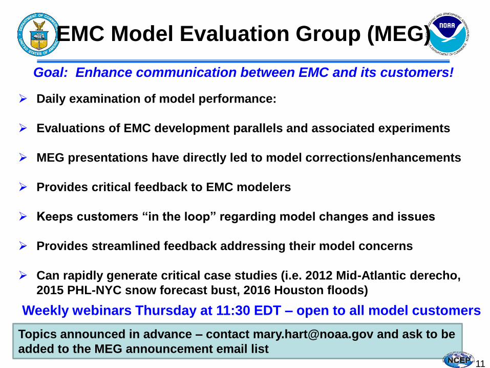
EMC Model Evaluation Group (MEG)
Goal: Enhance communication between EMC and its customers!
Daily examination of model performance:
Evaluations of EMC development parallels and associated experiments
MEG presentations have directly led to model corrections/enhancements
Provides critical feedback to EMC modelers
Keeps customers “in the loop” regarding model changes and issues
Provides streamlined feedback addressing their model concerns
Can rapidly generate critical case studies (i.e. 2012 Mid-Atlantic derecho,
2015 PHL-NYC snow forecast bust, 2016 Houston floods)
Weekly webinars Thursday at 11:30 EDT – open to all model customers
Topics announced in advance – contact [email protected] and ask to be
added to the MEG announcement email list 11

12
Hurricane Sandy (2012) Raises Public
Awareness of Modeling…… http://www.nbcnews.com/video/nightly-news/51108647#51108647
http://www.washingtonpost.com/blogs/capital-weather-gang/post/to-be-the-best-in-weather-forecasting-why-europe-is-beating-the-us/2013/03/08/429bfcd0-8806-11e2-9d71-
f0feafdd1394_blog.html

Computer Upgrade
Now in Place!
13
Tera
FLO
P p
er o
per
atio
nal
sys
tem
Reflectivity Observations HRRR 15 UTC 29 June 2012
Increased HPC capacity to 2.8 petaFLOPs
(for primary and backup, respectively–for a total of 5.6 PF)
Accepted for Operations: November 30th, 2015

14
External Review Committee for
NCEP Modeling Suite
Meeting 4-7 August 2015 in College Park
90 Participants across the community
Preliminary findings and recommendations briefed to NOAA leadership
Report published December 2015:
http://www.ncep.noaa.gov/director/ucar_reports/ucacn_20151207/UMAC_Final_Report_20151207-v14.pdf

15
UMAC Preliminary Findings and
Recommendations

UMAC Overarching
Recommendations
Reduce complexity of the NCEP Production Suite.
A unified, collaborative strategy for model development
across NOAA is needed.
Leverage the capabilities of the external community
Continue to enhance High Performance Computing
capabilities.
Execute strategic and implementation plans based on
stakeholder requirements.
16

Regional Hurricane
GFDL WRF-NMM
WRF(ARW, NMMB, NMM)
Climate Forecast System (CFS)
Short-Range Ensemble Forecast
Complexity???
What Complexity?
GFS, MOM4, NOAH, Sea Ice
North American Ensemble Forecast System
GEFS, Canadian Global Model
Dispersion HYSPLIT
Air Quality
CMAQ
Regional NAM
NMMB NOAH
3D
-VA
R
DA
Regional Bays •Great Lakes (POM)
•N Gulf of Mexico (FVCOM) •Columbia R. (SELFE) •Chesapeake (ROMS)
•Tampa (ROMS) •Delaware (ROMS)
•San Francisco (FVCOM)
Space Weather
ENLIL 17
North American Land Surface Data Assimilation
System NOAH Land Surface Model
Global Spectral NOAH
3D
-En
-Var
D
A
Global Forecast System (GFS)
3D
-VA
R
DA
3D
-VA
R
DA
WRF ARW
Rapid Refresh
3D
-VA
R
DA
Waves WaveWatch III
NWPS
Ocean HYCOM
Ecosystem EwE
Global Ensemble Forecast System (GEFS)
21 GFS Members
ESTOFS ADCIRC
SURGE SLOSH
P-SURGE SLOSH
WRF ARW
3D
-VA
R
DA
High Resolution RR
NEMS Aerosol Global Component (NGAC)
GFS & GOCART
WRF(ARW, NMMB)
High Res Windows

Next Generation Global Prediction System Path
to Unified Weather and Climate Guidance?
18
High-resolution nested grid simulations
using HiRAM and Finite Volume 3 (FV3)
NGGPS Seamless solutions for
tropical weather and
climate in a unified
global-to-local-scale
modeling framework

19
Overall Assessment & NGGPS Program Manager
Recommendation to NWS AA
The FV3 core represents the lowest risk, lowest cost alternative for
the new NGGPS atmospheric model
• Compared to the MPAS, FV3:
– Meets all technical needs
– Less expensive to implement
– Higher readiness for implementation
– Significantly better technical and computational performance
– Lower risk
• NGGPS strategy has always been to find and implement the best
global model (not the best convective scale model, although
nothing in results precludes eventual global/convective-scale
unification based on FV3)
Recommendation: Select GFDL FV3 and proceed to NGGPS
Phase 3 dynamic core integration and
implementation

20
Important Links to
NCEP Model Data
http://nomads.ncep.noaa.gov/pub/data/nccf/com/
NOAA Operational Model Archive and Distribution System (NOMADS):
ftp://ftp.ncep.noaa.gov/pub/data/nccf/com
NCEP FTP Server:
NCEP Model, Analysis and Guidance WEB Page:
http://mag.ncep.noaa.gov/
Questions About Model Data:
EMC Model Evaluation Group:
Model Suite Review Report: http://www.ncep.noaa.gov/director/ucar_reports/ucacn_20151207/UMAC_Final_Report_20151207-v14.pdf