Embed Size (px)
Citation preview

Welcome to National Park and National Forest lands in the North Cascades. Located east of I-5, there are many opportunities for you to enjoy this area with relatively easy access by several major highways. Starting up north: take a drive on the Mt. Baker Scenic Byway (State Route 542). This route starts in Bellingham, winds along the North Fork of the Nooksack River, and, from the town of Glacier, climbs 24 miles to an elevation of 5,100 feet at Artist Point in Heather Meadows. This destination is legendary for spectacular views of Mt. Baker, Mt. Shuksan and surrounding peaks.
For other stunning vistas, follow the northern part of the Cascade Loop along the North Cascades Scenic Highway (State Route 20). A side trip up the Baker Lake Road, 16 miles east of Sedro-Woolley, leads into the Baker Lake Basin, which hosts campgrounds, water recreation and numerous trails.
The 125-mile Skagit Wild and Scenic River System – made up of segments of the Skagit, Cascade, Sauk, and Suiattle Rivers – provides important wildlife habitat and recreation. The Skagit is home to one of the largest winter populations of bald eagles in the United States and provides spawning grounds for one-third of all salmon in Puget Sound.
NORTH CASCADES NATIONAL PARK COMPLEXMT. BAKER RANGER DISTRICT810 STATE ROUTE 20SEDRO-WOOLLEY, WA 98284-1239
EXPERIENCE YOUR AMERICA™
Recreational Opportunities
page 2
Trip Planning and Safety
page 3
Baker Lake and Mt. Baker Scenic Byway
pages 4 - 5
North Cascades Highway
pages 6 - 7
North Cascades National Park
Complexpages 8 - 10
Key Partners and Volunteer Opportunities
page 11
www.nps.gov/noca www.fs.fed.us/r6/mbs
The North Cascades Scenic Highway travels through the gateway communities of Concrete, Rockport, and Marblemount before reaching Ross Lake National Recreation Area within North Cascades National Park Complex.
Along the way, visit the North Cascades Visitor Center near Newhalem and many viewpoints above Gorge, Diablo and Ross lakes, which offer pristine perspectives of surrounding peaks. These mountains are home to more than 300 glaciers in the park and over 600 in the ecosystem.
Further to the east, Lake Chelan National Recreation Area features the third deepest lake in the nation. Gaze into the clear waters of Lake Chelan as you boat to the remote community of Stehekin and the Golden West Visitor Center.
Enjoy your visit. Be safe and be prepared.
FIND MORE INFO AT:
Banner photo: Courtesy of William Clark. Right: FS. Bottom: NPS/Bender Sidebar photos, from top down: David Snyder for the NPS, Snyder, FS, Snyder, Clark, Snyder
South of Fisher BasinNorth Cascades National Park
VISITOR INFORMATION GUIDENORTH CASCADES AND MT. BAKER

HIKING TRAILS AND CLIMBING PEAKS Hundreds of miles of trails lead into the North Cascades. Storm damage may affect your trip, so check trail conditions before you leave home. Most long hikes and climbs enter designated Wilderness Areas where special restrictions may apply. Climbers should choose experienced partners or licensed guides and fill out Voluntary Climbing Registers at the station nearest your climb.
Ask for a Wilderness Trip Planner and Climbing Notes or a list of outfitter guides. Visit the National Park and National Forest web sites for current recreation reports and climbing information.
BACKCOUNTRY National Forest: Backcountry camping does not require a permit, but a Northwest Forest Pass may be needed to park at some trailheads. Campers in the Mt. Baker National Recreation Area and some areas of the Wilderness must camp at designated spots. Campfires are not allowed in all backcountry areas and seasonal fire restrictions apply.
National Park: There are more than 200 backcountry camping sites, from boat-in sites to high alpine backpacking sites. Camping is allowed only at established sites. Camps include pit toilets, tent pads and in some cases, tables and fire pits. Backcountry permits are free, but are required for all overnight stays. Permits are issued in person only on a first-come, first-served basis. For permit information, contact the Wilderness Information Center (360) 854-7245 or visit www.nps.gov/noca/planyourvisit.
North Cascades and Mt. Baker Visitor Information Guide2
Explore, Experience and Enjoy
GO FISHING Fishing in Washington, including in National Parks and Forests, requires a valid Washington State fishing license.
In the National Forest, Baker Lake is a popular destination for trout fishing. The Skagit River, part of one of Washington’s major watersheds, is home to seven species of anadromous fish (five types of salmon and two types of trout) and freshwater trout and char.
In the National Park, Diablo and Gorge Lakes have been stocked with rainbow and cutthroat trout. Ross Lake offers quality sport fishing opening annually on July 1. Lake Chelan has fresh water cod, trout and kokanee, a land-locked species of salmon. The Stehekin River offers rainbow and cutthroat trout. Comply with special regulations listed in the Washington Department of Fish and Wildlife Sport Fishing Regulations, available wherever licenses are sold and online at: wdfw.wa.gov
WATER RECREATION River floating is an excellent adventure to plan. Experienced boaters run the Skagit, Nooksack and Stehekin rivers. Ask for a list of local outfitters at any ranger station.
Kayaking, canoeing and motor boating are other options. No personal watercraft (jet skis, etc.) are allowed in North Cascades National Park Complex. Motorboat and paddling rentals are available at Baker Lake, Ross Lake and Lake Chelan. Boat ramps are located at Baker Lake, Gorge Lake, Diablo Lake, Lake Chelan and the north end of Ross Lake at Hozomeen.
HORSEBACK RIDING Stock animals are welcome on trails maintained to stock standards. Trail rules and seasons of use vary and special rules apply in Wilderness Areas.
• Stock parties are limited to 12 (people + animals) on trails. • Grazing is permitted in the National Forest without a permit. But stock must use weed-free or processed feed while on National Forest lands.• Grazing with a permit is allowed in the Ross Lake and Lake Chelan National Recreation Areas. This can be obtained with your backcountry permit.• Grazing is prohibited in the National Park; pack in processed food pellets.
TRAVELING WITH YOUR DOG Dogs are not permitted on trails or in cross-country areas within the National Park. Leashed dogs are allowed in Ross Lake and Lake Chelan National Recreation Areas, along the Pacific Crest Trail and along roads in the National Park.
Dogs are allowed in the National Forest but must be leashed in developed recreation areas such as trailheads, campgrounds, picnic areas and Heather Meadows. For safety reasons, dogs are not allowed on Table Mountain Trail 681 in the Heather Meadows Area.
NORTH CASCADES BY BICYCLE Many people tour across the North Cascades by bicycle. Ask for the bulletin "Cycling the North Cascades Highway" at any ranger station. Mountain biking is not permitted on park or forest trails except where developed for that use. Riding is allowed on roads. Visitors should check for use restrictions on the trail system before heading out on a mountain bike trip.
TRAVELING WITH CHILDREN• Make the most out of your adventure by taking special safety precautions. • Children should remain with adults. • Establish rules for keeping together. • If separated, the child should hug a tree near an open area and stay put.• Pick trails and adjust goals to children’s ages and abilities.• Bring along the ten essentials. • Have children help make an emergency kit and make sure they know how to use the items.• Help children develop responsible outdoor practices.
ACTIVITY IDEAS FOR CHILDRENExplore with ears and eyes. Play observation games—watch for birds and identify plants, bugs and animal tracks. Listen for sounds of wildlife. Draw a picture or write a poem to remember the trip.
Spend time with a ranger or volunteer naturalist. Ask them for Junior Ranger and Family Fun activities and programs. Information is available at visitor centers and ranger stations. Top: NPS.
Bottom: Snyder
DO I NEED A PASS?North Cascades National Park Complex does not require an entrance fee or parking pass at trailheads. However, parking at certain trailheads, picnic areas and recreation sites in the National Forest does require a federal recreation pass.
The Northwest Forest Pass is valid throughout all National Forests in Oregon and Washington. The new America the Beautiful Pass, Interagency Senior and Interagency Access Pass (formerly known as the Golden Passports) are also honored at Northwest Forest Pass sites. When in the area, passes can be obtained at ranger stations and some local vendors. You may also purchase the passes in advance by calling (800) 270-7504 or online at: www.naturenw.org.
Passes should be displayed from the rearview mirror or on the dashboard of your vehicle when parked at a Northwest Forest Pass site.
Day Pass $5Annual Pass $30Interagency Annual Pass $80 * Interagency Senior Pass $10** The Interagency Access Pass is free for U.S. citizens with medically determined permanent disability. * Valid at U.S. Federal Recreation areas. ** Lifetime pass for U.S. citizens 62 and over.

SAFETY TIPSUse caution on access roads. Watch for obstructions such as rocks, sharp turns, parked vehicles and pedestrians.
Safeguard your possessions by keeping them out of sight. Lock your vehicle.
Carry the ten essentials listed on this page.
Stay on trails. Wear adequate footwear and use a topographic map and compass.
After hiking, check yourself for ticks, which may carry lyme disease.
Horses can startle easily. When stock approach, make your presence known and stand on the lower side of the trail.
Report trail damage to the nearest ranger station.
Do not depend on cell phones as there are many ‘dead spots.’
Travel Safely, Step Lightly
Many people come to the North Cascades to enjoy its rugged beauty and remote wildness. Recreating in natural areas, however, has inherent dangers and responsibilities. Conditions in mountainous areas can change very rapidly, even during a day trip. These travel tips can help you have a safe and responsible journey so that you, and future travelers, can enjoy the landscape to its fullest.
Always tell a friend your travel plans, including destination and expected return time.
Leave Fireworks at Home. Visitors are reminded that due to the potential fire danger, using or possessing fireworks of any kind is illegal on all federal and state-managed public lands in Washington throughout the year.
Be Alert - Check for Avalanche Danger.Before heading out into the backcountry, check with the Northwest Weather and Avalanche Center for current weather and avalanche forecasts. You can also call the Avalanche Information Hotline at 206-526-6677 (WA) and 503-808-2400 (OR).
Hunting on National Forest lands, Ross Lake and Lake Chelan National Recreation Areas is governed by Washington Game Regulations. Visitors should exercise caution when hiking during hunting season; wear bright clothing and make your presence known. Hunting is not allowed in North Cascades National Park.
North Cascades and Mt. Baker Visitor Information Guide 3
Managed by
User fee
Accessible facilities
Drinking water
Flush toilets
Vault toilets
Garbage facilities
Boat ramp
Hiking trail
Fishing
Dump stations
Silver Lake Park+
Douglas Fir+
Excelsior Group++
Silver Fir+
Kulshan
Horseshoe Cove+
Panorama Point+
Boulder Creek+
Park Creek+
Shannon Creek+
Rasar State Park+
Steelhead Park+
Goodell Creek
Newhalem Creek+
Goodell Group++
Colonial Creek
Lone Fir
Klipchuck
Early Winters
Marble Creek+
Mineral Park+
Hozomeen
Bayview Group++
SR 542
Baker Lake Road
Milepost 14-23
SR 20
Milepost81-180
Cascade River Road
Via B.C.
CAMPING AREASLocation
Campground: + Reservation available ++ Reservation required
Number of Campsites* hook-ups
available
100+*
30
2
21
104
34
2
16
10
12
20
38*
59*
21
110
3
142
27
46
13
22
22
122
FS = Forest Service SP = Washington State Park P = Puget Sound EnergyPS = National Park Service CP = County Park
CP
FS
FS
FS
P
FS
FS
FS
FS
FS
FS
SP
CP
NP
NP
NP
NP
NP
FS
FS
FS
FS
FS
Newhalem Group++ 2
ESSENTIALS
NP
• • • • • • • • • •• • • • • • •• • • •• • • • • •• • • • • • • •• • • • • • • •• • • •• • • • • • •• • •• • • •• • • • • • •• • • • • • • •• • • • • • •• • • • • •• • • • • • • •
• • • • • • • • • •• • • • • •• • • • • •• • • • •• • • • •• • • •• • • • • •
•
• • • • • • •• • •
••
•
LEAVE NO TRACEPlan Ahead and Prepare Know the regulations and special concerns for the region you are visiting. Prepare for emergencies and hazards.
Travel and Camp on Durable Surfaces Stay on the trail and camp in designated spots.Avoid fragile areas along waterways and in alpine meadows.
Minimize Campfire Impacts Use established fire rings or pits; keep fires small. Put out fires completely and scatter ashes. Use a stove when possible.
Respect Wildlife Observe wildlife from a distance. Never feed animals.
Be Considerate of Other Visitors Be courteous; yield to others. Strive to not disturb the natural ambiance.
Dispose of Waste ProperlyPack it in, pack it out. Use toilets where available. Otherwise, dig a cathole 6 to 8 inches deep away from trails and water.
Leave What you FindObserve, but do not take. Leave all natural and historical objects as you find them.
Top: FS, courtesy of Kevin Hammond
WHERE CAN I CAMP? Many public campgrounds in the North Cascades are accessible by car. Most sites are available on a first-come, first-served basis.
Group camps in the National Park are located at Goodell and Newhalem Creek campgrounds. National Forest group sites are available in the Baker Lake and Mt. Baker Scenic Byway areas.
National Park and Forest campground reservations can be made online at www.recreation.gov or at (877) 444-6777. Group sites can be reserved a year in advance and family sites may be reserved six months ahead.
For information about camping and other lodging opportunities in Washington State Parks, call (888) 226-7688 or visit www.parks.wa.gov
LODGING There are a variety of lodging options. Local Chamber of Commerce offices are happy to assist you. Remote accommodations in the North Cascades include: Ross Lake Resort (206) 386-4437 www.rosslakeresort.com
Stehekin Landing Resort www.stehekinlanding.com. Other lodging is available in Stehekin. Pick up the Stehekin Visitor Guide at any ranger station.
Learn about other tourism opportunities around the state at www.experiencewashington.com
THE 10 ESSENTIALS TO BRING ON EVERY TRIP:1) Food and water 2) Clothing 3) Navigation/map 4) Light 5) Fire starter 6) Sun protection 7) First aid kit 8) Knife 9) Emergency signal 10) Emergency shelter
North Cascades and Mt. Baker Visitor Information Guide4
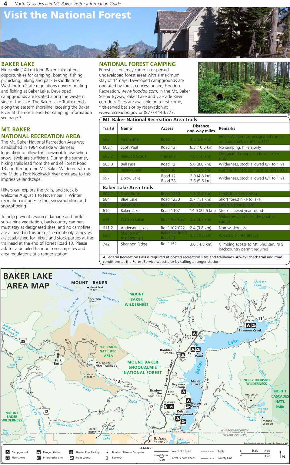
BAKER LAKENine-mile (14 km) long Baker Lake offers opportunities for camping, boating, fishing, picnicking, hiking and pack & saddle trips. Washington State regulations govern boating and fishing at Baker Lake. Developed campgrounds are located along the western side of the lake. The Baker Lake Trail extends along the eastern shoreline, crossing the Baker River at the north end. For camping information see page 3.
MT. BAKER NATIONAL RECREATION AREAThe Mt. Baker National Recreation Area was established in 1984 outside wilderness legislation to allow for snowmobile use when snow levels are sufficient. During the summer, hiking trails lead from the end of Forest Road 13 and through the Mt. Baker Wilderness from the Middle Fork Nooksack river drainage to this impressive landscape.
Hikers can explore the trails, and stock is welcome August 1 to November 1. Winter recreation includes skiing, snowmobiling and snowshoeing.
To help prevent resource damage and protect sub-alpine vegetation, backcountry campers must stay at designated sites, and no campfires are allowed in this area. One-night-only campsites are established for hikers and stock parties at the trailhead at the end of Forest Road 13. Please ask for a detailed handout on campsites and area regulations at a ranger station.
603 Park Butte Road 13 3.5 (5.6 km)
603.1 Scott Paul Road 13 6.5 (10.5 km) No camping, hikers only
603.3 Bell Pass Road 12 5.0 (8.0 km) Wilderness, stock allowed 8/1 to 11/1
696 Ridley Creek Road 38 5.5 (8.9 km) Not maintained, connects to trail 603.3
Mt. Baker National Recreation Area Trails
Baker Lake Area Trails
603.2 Railroad Grade Trail 603 1.0 (1.6 km) Designated camps, no fires, hikers only
Road 12 3.0 (4.8 km)Road 38 3.5 (5.6 km)
697 Elbow Lake Wilderness, stock allowed 8/1 to 11/1
Distance one-way miles
Trail # Name Access Remarks
604.1 Dock Butte Road 1230 1.5 (2.4 km) Leads to a scenic vista604 Blue Lake Road 1230 0.7 (1.1 km) Short forest hike to lake606 Baker River Road 11 2.6 (4.2 km) Enters National Park610 Baker Lake Road 1107 14.0 (22.5 km) Stock allowed year-round
611.2 Anderson Lakes Rd. 1107-022 2.4 (3.8 km) Non-wilderness
611 Watson Lakes Rd. 1107-022 2.3 (3.7 km)Wilderness, no fires, designated camps
623 0.5 ( 0.8 km) Accessible, interpretive Shadow of the Sentinels
A Federal Recreation Pass is required at posted recreation sites and trailheads. Always check trail and road conditions at the Forest Service website or by calling a ranger station.
Enters Wilderness, designated camps, no fires, stock ok 8/1 to 11/1
FS
NATIONAL FOREST CAMPINGForest visitors may camp in dispersed undeveloped forest areas with a maximum stay of 14 days. Developed campgrounds are operated by forest concessionaire, Hoodoo Recreation, www.hoodoo.com, in the Mt. Baker Scenic Byway, Baker Lake and Cascade River corridors. Sites are available on a first-come, first-served basis or by reservation at www.recreation.gov or (877) 444-6777.
Baker Lk. RoadRoad 11
Visit the National Forest
742 3.0 ( 4.8 km) Climbing access to Mt. Shuksan, NPS backcountry permit required
Shannon Ridge Rd. 1152

MazamaLake
Bagley
Lakes
IcebergLake
GalenaChainLakes
HayesLake
ArbuthnotLake
HighwoodLake
PictureLake
HuntoonPoint
Mt. Baker
Highway
To Glacier, WA(USFS/NPSInformation)
ToLake Ann
To Ptarmigan RidgeTrail 682.1
Artist Point
Bagley LakesTrailhead Parking
Mt. Baker Ski AreaHeather Meadows Day Lodge
Mount Herman
Mazama Dome
Heather MeadowsVisitor Center(Summer Only)
Mt. BakerSki AreaWhite SalmonDay Lodge
Gate closedin summer
Austin PassPicnic Area
Mount Baker Ski Area
Shuksan
Arm
Table Mountain
5426286 ft1916 m
5842 ft1781 m
Trail 600
Trail 681
Picture Lake PathTrail 735
Bagle
yLa
kes
Wild
G oose
Trai
l
Chai
nLa
kes
Trai
l
Chain Lakes Trail
Trail
682
682Trail
Fire andIce Trail
Trail 684.2
Wild
Go
ose
Artist RidgeTrail
1.0 km
0
0
0.7 miScale
MOUNT BAKERWILDERNESS
MT. BAKER SCENIC BYWAYThe scenic Mt. Baker Byway winds along the North Fork of the Nooksack River, ending at Artist Point at 5,100 feet (1545 m) in Heather Meadows. The last 24 miles (39 km) is designated as a National Forest Scenic Byway. At the road’s end, trail systems lead into the Mt. Baker Wilderness. During winter months motor traffic ends at the Mt. Baker Ski Area three miles (6 km) below Artist Point.
POINTS OF INTERESTGLACIER PUBLIC SERVICE CENTER - MP 34:Stop by to get current conditions from Forest Service and National Park staff.
Boyd Creek Interpretive Trail, FS Road 37: This short, self-guided nature trail focuses on components of healthy fish habitat.
Nooksack Falls, MP 40: A dramatic waterfall plummets more than 100 feet over rocky outcrops. A fence-lined pathway leads to a viewpoint.
Shuksan Picnic Area: Day use area at the base of Forest Road 32 (Hannegan Road). Pass required.
HEATHER MEADOWS AREAVisit this spectacular sub-alpine setting along the upper reaches of the Mt. Baker Scenic Byway. Spread out a picnic lunch at Austin Pass Picnic Area and check in with staff at the Heather Meadows Visitor Center. Open daily in summer from 10 am to 4 pm. A valid Federal Recreation Pass is required for parking in the area during the summer season.
Hike along a network of scenic trails and enjoy several self-guided interpretive opportunities and accessible viewpoints. Several longer hikes lead into the surrounding Mt. Baker Wilderness, where Wilderness regulations apply. When entering such areas, be prepared for risk and challenge. The terrain can be rugged and the weather unpredictable.
During winter months, check avalanche forecasts by calling at www.nwac.us or call (206) 526-6677.
North Cascades and Mt. Baker Visitor Information Guide 5
MT. BAKER SCENIC BYWAY
Glacier Area TrailsDistance
one-way milesTrail # Name Access Remarks
A Northwest Forest Pass is required at posted recreation sites and trailheads. Always check trail and road conditions at the Forest Service website or by calling a ranger station.
POPULAR TRAILS ALONG THE MT. BAKER SCENIC BYWAY
625 Damfino Lakes Road 31 3.0 (4.8 km) No fires, connects with High Divide
671 Church Mountain Road 3040 4.2 (6.8 km) Steep hike up forested slopes677 Heliotrope Ridge Road 39 3.7 (6.0 km) Wilderness, no fires678 Skyline Divide Road 37 5.5 (8.9 km) Wilderness, no fires, stock 8/1 to 11/1687 Horseshoe Bend Hwy 542 1.5 (2.4 km) Follows Nooksack River673 Goat Mountain Road 32 4.0 (6.4 km) Wilderness, stock allowed 8/1 to 11/1
674 Hannegan Pass Road 32 5.0 (8.0 km) Wilderness, no fires, enters National Park, stock allowed 7/1 to 11/1
685 Winchester Mtn. Road 3065 2.0 (3.2 km)
686 Tomyhoi Lake Road 3065 4.0 (6.4 km) Wilderness, no fires
Heather Meadows Area Trails600 Lake Ann Hwy 542 4.8 (7.7 km) Wilderness, no fires682.1 Ptarmigan Ridge Trail 682 5.0 (8.0 km) Wilderness, no fires681 Table Mountain Hwy 542 0.7 (1.1 km) Wilderness, no fires, no dogs
682 Chain Lakes Hwy 542 6.5 loop Wilderness, no fires, camp at designated sites only
735 Picture Lake Hwy 542 0.5 loop Accessible, Interpretive684.2 Fire and Ice Hwy 542 0.5 loop Accessible, Interpretive684.3 Wild Goose Hwy 542 2.5 (4.0 km) No camping one mile from trail669 Artist Ridge Hwy 542 1.0 loop Accessible viewpoint
630 High Divide Hwy 542 13.0 (20.9 km) Wilderness, no fires, stock 8/1 to 11/1
686.1 Yellow Aster Butte Trail 686 2.0 (3.2 km) Wilderness, no fires, Jct 686 at 1.5 mi
High clearance vehicle needed on road, Wilderness, no fires
626 Boyd Creek Road 37 0.25 (0.4 km) Accessible, Interpretive
HEATHER MEADOWSDETAIL MAP

CascadeRiver
Road
Cascad e RiverRoad
GreenLake
GraniteLakes Doubtful
Lake
RainyLake
BlueLakeLake Ann
HiddenLake
MoraineLake
PorcupineCreek
ThorntonLakes
SourdoughLake
GorgeLake
Shuksa
n
CreekCreek
Diablo Lake
Creek RO
SS
LA
KE
Ruby Creek
Crat
er
Cre
ek Creek
BoulderCreek
Canyon
Beaver
Big
Goodell
Creek
Thunder
JordanCreek
Marble Creek
Bo
ulder
Creek
River
Sauk
Rive
r
Skag
it
Creek
Creek
Creek
Creek
East Creek
Granite
Creek
Swamp Creek
Methow River
Granite
Creek
Fisher
Panther
Th
un
der
Diobsud
Bacon
Creek
Noisy
North Fork
Mill
Creek
SlateCreek
ShuksanLake
BerdeenLake
BarnabySlough
Falls Lake
Jug Lake
JordanLakes
FoundLakes
SlideLake Whale Lake
Cyclone Lake
MonogramLake
Blum
Baker River
Creek
Creek
Creek
Cascade
Otter Cr
River
Illabot
C reek
Rocky
JackmanCreek
Finney
Creek
Cr
Pres
sentin
GrandyLake
RidleyCr
LakeShannon
BakerLake
Skagit
River
North Cascades National ParkWilderness Information Center
North Cascades National ParkVisitor Center
CRESCENT CREEK SPIRES
PICKETRA
NG
E
GorgeDam
ThorntonLakesRoad
GoodellCreek
NewhalemCreek
MARBLEMOUNT
NEWHALEM
DIABLO
BucknerMountain9112ft2777m
Mineral Park
North Fork of Bridge CreekTrail
Rainy LakeNational Recreation Trail
Rainy PassWashington Pass
Overlook
Universal accessto Rainy Lake
Mount Ballard8301ft2530m
Harts Pass
MC
KA
YRID
GE
O K A N O G A N
N A T I O N A L
F O R E S T
Ross Dam
RubyCreek
Ross LakeResortBoat taxiBoat fuel
EnvironmentalLearning Center
DiabloDam
PASAYTEN
WILDERNESS
Ross LakeOverlook
Marble Creek
To Sedro-Woolley, I-5
To Darrington
To Winthrop
CONCRETE
ROCKPORT
Upper BakerDam
BakerDam
The Portage
MOUNT BAKER
WILDERNESS
M O U N T B A K E R -
S N O Q U A L M I E
N A T I O N A L
F O R E S T
NOISY-
DIOBSUD
WILDERNESS
MOUNT BAKERNATIONAL RECREATION
AREA(Forest Service)
Bake
rLa
keRoad
Sauk
Concrete
Valley
Road
Rockport Cascade Road
Road
CreekIllabot
Park Creek
Panorama Point
Shadow ofSentinels
BoulderCreek
Kulshan
HorseshoeCove
Shannon CreekBaker LakeResort
RockportState Park
Howard MillerSteelhead Park
South SkagitHwy
12
17
13
11
Grandy LakeCampground
Colonial CreekCampground
Diablo Lake Overlook
Gorge Creek FallsOverlook
Happy Creek Forest Walk
Sourdough Mountain6120ft 1865m
Davis Peak7051ft2149m
Bacon Peak7061ft2152m
Mount Triumph7271ft2216m
Damnation Peak5635ft1718m
DevilsDome6982ft2128m
Jack Mountain
DiobsudButtes5893ft1796m
Sauk Mountain5541ft1689m
Finney PeaK
Lookout Mountain5699ft1737m
Pyramid Peak7182ft 2189m
Ruby Mountain7408ft 2258m
CraterMountain
8128ft2477m
Gabriel Peak7920ft2414m
Easy Pass6525ft1989m
Fisher Peak8060ft2457m
Liberty Bell Mtn7740ft, 2359m
Mesahchie Peak8795ft2681m
Mount Arriva8215ft2504m
5477ft1669m
Washington Pass
6837ft2084m
Cutthroat Pass
Rainy Pass4855ft1480m
Johannesburg Mtn8200ft2499m
Mount Logan9087ft2770m
Red Mountain7658ft2334m
Sahale Mtn8680ft2646m
Park Creek Pass6059ft1847m
Forbidden Peak8815ft2687m
8894ft2711m
Boston Peak
Cascade Pass5392ft 1643m
Black Peak8970ft2734m
GoodeMountain
9220ft2810m
Eldorado Peak8868ft2703m
Klawatti Peak8485ft2586m
Mount Despair7292ft2223m
MountChallenger
Mount Blum7680ft2341m
Mount Baker10781ft3286m
Suiattle Mountain5040ft1536m
Kulshan Cartographic Services, Bellingham WA
20
20
20
20
20
530
530530
No
rthC
ascadesH
ighway
(closed
mid-N
ovto
April)
Pacif
icCrest
National
Sc
enic
Trai
l
N O R T H C A S C A D E S
N A T I O N A L P A R K
N O R T H C A S C A D E S
N A T I O N A L P A R K
ROSS LAKENATIONAL
RECREATIONAREA
ROSS LAKENATIONAL
RECREATION AREA
FROM WEST TO EAST
BAKER LAKE AND MT. BAKER NATIONAL RECREATION AREAAt MP 82 on SR 20 turn north onto Baker Lake Road #11 for access to water recreation, hiking and campgrounds. After entering the National Forest, Roads #12 and #13 lead to the Mt. Baker National Recreation Area for winter sports and hiking on the south side of Mt. Baker.
ROCKPORT MP 96-98. Two parks, Rockport State Park and Howard Miller Steelhead Park, offer excellent day hikes near the Skagit River. State Route 530 goes south along the Sauk River, part of the Skagit Wild and Scenic River System, and accesses roads to the Glacier Peak Wilderness. Forest Roads 1030 and 1036 provide access to the Sauk Mt. Trail.
MARBLEMOUNT MP 105-107. This is the last stop for full services and gas before Mazama and Winthrop. National Park backcountry permits are issued at the Wilderness Information Center one mile (1.6 km) north of SR 20 on Ranger Station Road. East of town, the Cascade River Road leads through the National Forest to campgrounds and the Cascade Pass Trailhead.
NEWHALEM MP 120. Across the Skagit River is the North Cascades National Park Visitor Center with several short trails including To Know a Tree, Rock Shelter and River Loop. Newhalem Creek and Goodell Creek Campgrounds offer tent, RV and group campsites. In town, Seattle City Light runs an Information and Tour Center with facilities, walking tours, trails including Trail of the Cedars and Ladder Creek Falls and a general store.
GORGE CREEK FALLS AND OVERLOOK MP 123. Rest stop and accessible loop trail offering views of the gorge and dam.
COLONIAL CREEK CAMPGROUND MP 130. Located on Diablo Lake, this campground has camp hosts and offers naturalist programs in the summer, an accessible picnic area and fishing platform. Thunder Creek, Thunder Woods and Thunder Knob trails leave from the campground and go through diverse forests to scenic views.
DIABLO LAKE OVERLOOK MP 132.Viewpoint has a variety of vistas, restrooms, a map, and shelter.
ROSS DAM TRAILHEAD MP 134.The Ross Dam, West Bank and Happy Panther trails are accessed from this area, as well as Ross Lake Resort. SR 20 winter gate closure November through April.
ROSS LAKE OVERLOOKS MP 135-136. View Ross Lake, mountains and displays about ancient glaciers, lakes and more recent fire lookouts. Walk the Happy Creek Forest accessible trail.
EAST BANK TRAILHEAD M.P. 138Panther Creek, East Bank and Ruby Creek trails converge near here. A new option is to follow the Happy Panther Trail west from here.
RAINY PASS PICNIC AREA M.P. 158One-mile (1.6 km) accessible trail leads to Rainy Lake and waterfall views. Longer hikes go to Lake Ann (2 mi, 3.2 km) or around Maple Pass Loop (7.5 mi, 12 km). Typically not snow-free until late July.
WASHINGTON PASS M.P. 162Highest point along the highway, enjoy views of Liberty Bell and Early Winters Spires.
UPPER METHOW VALLEY M.P. 180Mazama turnoff to Hart’s Pass (22 mi, 35.4 km). Road unpaved.
North Cascades and Mt. Baker Visitor Information Guide6 North Cascades and Mt. Baker Visitor Information Guide 7
ACCESSIBLE INTERPRETIVE TRAILSShadow of the Sentinels: 0.5 miles (0.8 km) trail through old growth forest.
Sterling Munro: 330 ft (120 m) boardwalk with view of Picket Range.
River Loop: 1.8 miles (2.9 km) trail begins at North Cascades National Park Visitor Center or in Newhalem Creek Campground for easier grade.
Rock Shelter: 0.3 miles (0.6 km) trail to Native American campsite above Newhalem Creek, moderate grade.
SEDRO-WOOLLEY TO NEWHALEM Sedro-Woolley to Concrete Concrete to Rockport Rockport to Marblemount Marblemount to Newhalem
NEWHALEM TO WASHINGTON PASS Newhalem to Diablo Overlook Diablo Overlook to Rainy Pass Rainy Pass to Washington Pass
WASHINGTON PASS TO WINTHROP Washington Pass to Mazama Mazama to WinthropTOTAL TRIP:
552488
15
4414264
301713
129
7525101525
6525355
452520
3 hrs
How far is it? How long will it take? In Miles In Minutes
Photos from left to right: NPS, NFS, NPS, NPS
Gorge Overlook: 0.5 miles (0.8 km) 0.2 miles paved with views of Gorge Lake and Gorge Dam.
Happy Creek Forest Walk: 0.3 miles (0.5 km) boardwalk through ancient creekside forest.
Rainy Lake: One mile (1.6 km) paved trail leads to Rainy Lake with views of waterfalls.
Washington Pass Overlook: 810 ft (250 m) loop trail with view of mountains from a high bluff.

CascadeRiver
Road
Cascad e RiverRoad
GreenLake
GraniteLakes Doubtful
Lake
RainyLake
BlueLakeLake Ann
HiddenLake
MoraineLake
PorcupineCreek
ThorntonLakes
SourdoughLake
GorgeLake
Shuksa
n
Creek
Creek
Diablo Lake
Creek RO
SS
LA
KE
Ruby Creek
Crat
er
Cre
ek Creek
BoulderCreek
Canyon
Beaver
Big
Goodell
Creek
Thunder
JordanCreek
Marble Creek
Bo
ulder
Creek
River
Sauk
Rive
r
Skag
it
Creek
Creek
Creek
Creek
East Creek
Granite
Creek
Swamp Creek
Methow River
Granite
Creek
Fisher
Panther
Th
un
der
Diobsud
Bacon
Creek
Noisy
North Fork
Mill
Creek
SlateCreek
ShuksanLake
BerdeenLake
BarnabySlough
Falls Lake
Jug Lake
JordanLakes
FoundLakes
SlideLake Whale Lake
Cyclone Lake
MonogramLake
Blum
Baker River
Creek
Creek
Creek
Cascade
Otter Cr
River
Illabot
C reek
Rocky
JackmanCreek
Finney
Creek
Cr
Pres
sentin
GrandyLake
RidleyCr
LakeShannon
BakerLake
Skagit
River
North Cascades National ParkWilderness Information Center
North Cascades National ParkVisitor Center
CRESCENT CREEK SPIRES
PICKETRA
NG
E
GorgeDam
ThorntonLakesRoad
GoodellCreek
NewhalemCreek
MARBLEMOUNT
NEWHALEM
DIABLO
BucknerMountain9112ft2777m
Mineral Park
North Fork of Bridge CreekTrail
Rainy LakeNational Recreation Trail
Rainy PassWashington Pass
Overlook
Universal accessto Rainy Lake
Mount Ballard8301ft2530m
Harts Pass
MC
KA
YRID
GE
O K A N O G A N
N A T I O N A L
F O R E S T
Ross Dam
RubyCreek
Ross LakeResortBoat taxiBoat fuel
EnvironmentalLearning Center
DiabloDam
PASAYTEN
WILDERNESS
Ross LakeOverlook
Marble Creek
To Sedro-Woolley, I-5
To Darrington
To Winthrop
CONCRETE
ROCKPORT
Upper BakerDam
BakerDam
The Portage
MOUNT BAKER
WILDERNESS
M O U N T B A K E R -
S N O Q U A L M I E
N A T I O N A L
F O R E S T
NOISY-
DIOBSUD
WILDERNESS
MOUNT BAKERNATIONAL RECREATION
AREA(Forest Service)
Bake
rLa
keRoad
Sauk
Concrete
Valley
Road
Rockport Cascade Road
Road
CreekIllabot
Park Creek
Panorama Point
Shadow ofSentinels
BoulderCreek
Kulshan
HorseshoeCove
Shannon CreekBaker LakeResort
RockportState Park
Howard MillerSteelhead Park
South SkagitHwy
12
17
13
11
Grandy LakeCampground
Colonial CreekCampground
Diablo Lake Overlook
Gorge Creek FallsOverlook
Happy Creek Forest Walk
Sourdough Mountain6120ft 1865m
Davis Peak7051ft2149m
Bacon Peak7061ft2152m
Mount Triumph7271ft2216m
Damnation Peak5635ft1718m
DevilsDome6982ft2128m
Jack Mountain
DiobsudButtes5893ft1796m
Sauk Mountain5541ft1689m
Finney PeaK
Lookout Mountain5699ft1737m
Pyramid Peak7182ft 2189m
Ruby Mountain7408ft 2258m
CraterMountain
8128ft2477m
Gabriel Peak7920ft2414m
Easy Pass6525ft1989m
Fisher Peak8060ft2457m
Liberty Bell Mtn7740ft, 2359m
Mesahchie Peak8795ft2681m
Mount Arriva8215ft2504m
5477ft1669m
Washington Pass
6837ft2084m
Cutthroat Pass
Rainy Pass4855ft1480m
Johannesburg Mtn8200ft2499m
Mount Logan9087ft2770m
Red Mountain7658ft2334m
Sahale Mtn8680ft2646m
Park Creek Pass6059ft1847m
Forbidden Peak8815ft2687m
8894ft2711m
Boston Peak
Cascade Pass5392ft 1643m
Black Peak8970ft2734m
GoodeMountain
9220ft2810m
Eldorado Peak8868ft2703m
Klawatti Peak8485ft2586m
Mount Despair7292ft2223m
MountChallenger
Mount Blum7680ft2341m
Mount Baker10781ft3286m
Suiattle Mountain5040ft1536m
Kulshan Cartographic Services, Bellingham WA
20
20
20
20
20
530
530530
No
rthC
ascadesH
ighway
(closed
mid-N
ovto
April)
Pacif
icCrest
National
Sc
enic
Trai
l
N O R T H C A S C A D E S
N A T I O N A L P A R K
N O R T H C A S C A D E S
N A T I O N A L P A R K
ROSS LAKENATIONAL
RECREATIONAREA
ROSS LAKENATIONAL
RECREATION AREA
FROM WEST TO EAST
BAKER LAKE AND MT. BAKER NATIONAL RECREATION AREAAt MP 82 on SR 20 turn north onto Baker Lake Road #11 for access to water recreation, hiking and campgrounds. After entering the National Forest, Roads #12 and #13 lead to the Mt. Baker National Recreation Area for winter sports and hiking on the south side of Mt. Baker.
ROCKPORT MP 96-98. Two parks, Rockport State Park and Howard Miller Steelhead Park, offer excellent day hikes near the Skagit River. State Route 530 goes south along the Sauk River, part of the Skagit Wild and Scenic River System, and accesses roads to the Glacier Peak Wilderness. Forest Roads 1030 and 1036 provide access to the Sauk Mt. Trail.
MARBLEMOUNT MP 105-107. This is the last stop for full services and gas before Mazama and Winthrop. National Park backcountry permits are issued at the Wilderness Information Center one mile (1.6 km) north of SR 20 on Ranger Station Road. East of town, the Cascade River Road leads through the National Forest to campgrounds and the Cascade Pass Trailhead.
NEWHALEM MP 120. Across the Skagit River is the North Cascades National Park Visitor Center with several short trails including To Know a Tree, Rock Shelter and River Loop. Newhalem Creek and Goodell Creek Campgrounds offer tent, RV and group campsites. In town, Seattle City Light runs an Information and Tour Center with facilities, walking tours, trails including Trail of the Cedars and Ladder Creek Falls and a general store.
GORGE CREEK FALLS AND OVERLOOK MP 123. Rest stop and accessible loop trail offering views of the gorge and dam.
COLONIAL CREEK CAMPGROUND MP 130. Located on Diablo Lake, this campground has camp hosts and offers naturalist programs in the summer, an accessible picnic area and fishing platform. Thunder Creek, Thunder Woods and Thunder Knob trails leave from the campground and go through diverse forests to scenic views.
DIABLO LAKE OVERLOOK MP 132.Viewpoint has a variety of vistas, restrooms, a map, and shelter.
ROSS DAM TRAILHEAD MP 134.The Ross Dam, West Bank and Happy Panther trails are accessed from this area, as well as Ross Lake Resort. SR 20 winter gate closure November through April.
ROSS LAKE OVERLOOKS MP 135-136. View Ross Lake, mountains and displays about ancient glaciers, lakes and more recent fire lookouts. Walk the Happy Creek Forest accessible trail.
EAST BANK TRAILHEAD M.P. 138Panther Creek, East Bank and Ruby Creek trails converge near here. A new option is to follow the Happy Panther Trail west from here.
RAINY PASS PICNIC AREA M.P. 158One-mile (1.6 km) accessible trail leads to Rainy Lake and waterfall views. Longer hikes go to Lake Ann (2 mi, 3.2 km) or around Maple Pass Loop (7.5 mi, 12 km). Typically not snow-free until late July.
WASHINGTON PASS M.P. 162Highest point along the highway, enjoy views of Liberty Bell and Early Winters Spires.
UPPER METHOW VALLEY M.P. 180Mazama turnoff to Hart’s Pass (22 mi, 35.4 km). Road unpaved.
North Cascades and Mt. Baker Visitor Information Guide6 North Cascades and Mt. Baker Visitor Information Guide 7
ACCESSIBLE INTERPRETIVE TRAILSShadow of the Sentinels: 0.5 miles (0.8 km) trail through old growth forest.
Sterling Munro: 330 ft (120 m) boardwalk with view of Picket Range.
River Loop: 1.8 miles (2.9 km) trail begins at North Cascades National Park Visitor Center or in Newhalem Creek Campground for easier grade.
Rock Shelter: 0.3 miles (0.6 km) trail to Native American campsite above Newhalem Creek, moderate grade.
SEDRO-WOOLLEY TO NEWHALEM Sedro-Woolley to Concrete Concrete to Rockport Rockport to Marblemount Marblemount to Newhalem
NEWHALEM TO WASHINGTON PASS Newhalem to Diablo Overlook Diablo Overlook to Rainy Pass Rainy Pass to Washington Pass
WASHINGTON PASS TO WINTHROP Washington Pass to Mazama Mazama to WinthropTOTAL TRIP:
552488
15
4414264
301713
129
7525101525
6525355
452520
3 hrs
How far is it? How long will it take? In Miles In Minutes
Photos from left to right: NPS, NFS, NPS, NPS
Gorge Overlook: 0.5 miles (0.8 km) 0.2 miles paved with views of Gorge Lake and Gorge Dam.
Happy Creek Forest Walk: 0.3 miles (0.5 km) boardwalk through ancient creekside forest.
Rainy Lake: One mile (1.6 km) paved trail leads to Rainy Lake with views of waterfalls.
Washington Pass Overlook: 810 ft (250 m) loop trail with view of mountains from a high bluff.

In addition to the Junior Ranger program, North Cascades National Park also offers Family Fun Packs and hidden Questing activities within the park. Learn more at any of the visitor centers.
North Cascades National Park ComplexNorth Cascades and Mt. Baker Visitor Information Guide8
THE NORTH CASCADES ARE CALLING
“The sublimity of true mountain scenery in the Cascade Mountains . . . must be seen, it cannot be described. Nowhere do the mountain masses and peaks present such a strange, fantastic, dauntless and startling outline as here. Whoever wishes to see nature in all its wildness must go and visit these mountain regions…”– Henry Custer, United States Northwest Border Commission topographer, 1859
North Cascades National Park, Ross Lake National Recreation Area and Lake Chelan National Recreation Area offer unique opportunities to get outside and experience wilderness. Whether you enjoy hiking, camping, fishing, climbing or just taking a drive along a scenic highway, the park has something for you! On this and the following pages learn how to:
• Become a Junior Ranger • Do Your Part! for Climate Friendly Parks • Drive the scenic North Cascades Highway and take the family for a hike • Travel picturesque Lake Chelan aboard the Lady of the Lake to the unique community of Stehekin • Be involved: volunteer
Take advantage of the many opportunities to learn, recreate and spend time with family in these special places that have been saved by the American people so that all may experience our heritage.
In 2009, North Cascades National Park launched a new Junior Ranger program that consists of four age-appropriate activity booklets. Each is designed to help get kids outside, have fun and learn about unique natural and cultural resources of your park. A "totem animal" guides kids through the activities and offers instruction, hints and ways to apply their new knowledge during their visit to the North Cascades.
BECOME A JUNIOR RANGER!
DO YOUR PART! FOR CLIMATE FRIENDLY PARKS
With over 300 glaciers representing 1/3 of those remaining in the lower 48 states, the ecosystem and landscapes of North Cascades National Park Complex will experience unprecedented change in the future. Recognizing the drastic consequences of climate change, park staff is committed to reducing the park’s contribution to greenhouse gasses, supporting climate science, research and adaptive management and leading public awareness and education. “Do Your Part! for Climate Friendly Parks” is the first interactive online program in the country that provides national park visitors and supporters with the tools to understand and reduce their carbon footprints and thereby help protect our national parks from global warming.
LEARN MORE:Climate Friendly Parkswww.nps.gov/climatefriendlyparks
Do Your Part! for Climate Friendly Parkswww.DoYourPartParks.org
The EPA Climate Change Kids Sitewww.epa.gov/climatechange/kids
U.S. Forest Service Climate Change Resource Center: www.fs.fed.us/ccrc
• Wilderness Information Center • North Cascades Visitor Center • Golden West Visitor Center
Pick up a FREE booklet at any of the following locations: • Glacier Public Service Center • Park and Forest Information Center • Hozomeen
Top: Werran, courtesy of REI. Bottom: Snyder
JUNIOR RANGER
NO
RTH
CASCADES NATIONALPA
RK
Explore our growing digital image library on Flickr:www.flickr.com/northcascadesnationalparkBe inspired by beautiful photographs and even submit your own!

NEWHALEM The North Cascades were still remote and wild in the 1910s, when the power of the Skagit River was first being harnessed. Newhalem was built as a company town for the men who worked at the dams and their families. Learn about the area’s natural and cultural history by exploring interactive exhibits, watching theater presentations or talking with rangers at the North Cascades National Park Visitor Center. The interpretive staff at the center present a wide variety of programs including evening programs at both Colonial Creek and Newhalem Creek campgrounds.
Ross Lake National Recreation Area
Sterling Munro 120 0.1 (0.2 km) very easy Accessible boardwalk with view of the Picket Range
River Loop 120 1.8 (2.9 km) easy Accessible, forested path to the Skagit River
Rock Shelter 120 0.3 (0.5 km) easy Accessible trail to historic site used by Native People 1,400 years ago
Gorge Overlook 123 0.5 (0.8 km) easy Accessible trail with views of a deep gorge and waterfall
Pyramid Lake 127 4.2 (6.8 km) moderate Moderately steep hike through diverse habitat leading to a lake, no camping
Diablo Lake 128 7.6 (12.2 km) moderate Offers views of glaciers and peaks, located on north side of Diablo Lake
Thunder Knob 130 3.6 (5.8 km) easy Hike through dry forest terrain, views of Diablo Lake and surrounding peaks
Thunder Creek* 130 1.6-46 (2.8-74 km) easy-difficult Excellent day hikes, extended trips to Stehekin Valley via Park Creek Pass
Thunder Woods 130 0.9 (1.5 km) moderate Nature trail that highlights the unique habitat near Thunder Creek
Ross Dam 134 1.5 (2.4 km) moderate Short, steep trail down to Ross Dam
Happy Panther 134 10.5 (16.9 km) easy Follows south shore of Ross Lake, connects Ross Dam Trail to East Bank Trail
Happy Creek 134 0.3 (0.5 km) very easy Accessible boardwalk interpretive trail through ancient forest
East Bank* 138 0.5-62 (0.8-99.8 km) easy-moderate Winds along forested path, loops around Desolation Peak to Hozomeen
Trail Name Milepost Difficulty RemarksRound-Trip
Distance in miles
POPULAR TRAILS ALONG NORTH CASCADES HIGHWAY
The North Cascades Highway, or State Route 20, meanders through the upper Skagit watershed among forests and soaring peaks. A variety of activities can be accessed from the corridor including challenging hikes and paddling. A number of scenic vistas, picnic areas, campgrounds and short trails are available for those seeking a more relaxing trip.
Below Newhalem, the free-flowing portion of the Skagit River offers excellent wildlife viewing and rafting opportunities. A raft launch is located next to Goodell Creek Campground, but careful planning is required to float the swift Skagit as there can be seasonal hazards and closures.
Diablo Lake offers the only easy access for launching watercraft off from State Route 20. The lake, surrounded by glaciated peaks, is a brilliant turquoise blue in summer. This unique color is caused by refracted light on fine rock sediment called glacial flour, carried into the lake by glacier-fed streams. There are three small boat-in campgrounds where a backcountry permit is required.
Ross Lake, the largest of the three reservoirs, winds nearly 25 miles from Ross Dam to Hozomeen on the Canadian border. The only vehicle access is via Hope, British Columbia, but small motor boats (14’ and under) and canoes/kayaks can be portaged around Ross Dam from Diablo Lake. Nineteen boat-in campgrounds (backcountry permit required) and Ross Lake Resort are available for those looking to spend multiple days in this remote landscape.
Newhalem Area Trails
North Cascades and Mt. Baker Visitor Information Guide 9
NPS
*Obtain a permit at the Wilderness Information Center in Marblemount for all backcountry camping.

LODGINGA variety of accommodations are available in Stehekin ranging from resorts to backcountry camping.
For a complete list of lodgings, services and schedules, consult the National Park website (www.nps.gov/noca/planyourvisit/stehekin.htm) or call the Golden West Visitor Center (360) 854-7365 ext. 14.
Lake Chelan National Recreation Area
Embrace the pioneer spirit and journey to the remote community of Stehekin, located on the northern shore of Lake Chelan. Nestled in a serene valley and surrounded by wilderness, Stehekin offers a variety of attractions to suit all visitors. Whether you are seeking a quiet weekend or want to challenge your muscles on rugged peaks, Stehekin and the surrounding trails have plenty of new sights to discover.
WHAT TO SEE, WHAT TO DOThe Historic Golden West Visitor Center: knowledgeable rangers can assist you with trail and camp conditions, backcountry permits, and general information. The visitor center also offers daily naturalist programs featuring natural and cultural history, including evening programs, short talks, guided walks, bicycle tours and Junior Ranger activities.
The Golden West Gallery: located in the visitor center, displays artwork inspired by the North Cascades.
Stehekin Pastry Company: no visit is complete without stopping by the bakery for a fresh, delicious treat.
Buckner Orchard: an intact example of early entrepreneurial farming in the Pacific Northwest and the only farm currently producing Common Delicious apples in the United States.
Hike: more than 11 trails varying in difficulty and length.
Camp: more than 13 campsites are available with locations on the lakeshore or deep in the wilderness.
North Cascades and Mt. Baker Visitor Information Guide10
TRAVELING TO STEHEKINFerryLake Chelan Boat Company provides round-trip service between Chelan and Stehekin with scheduled stops at Field’s Point and Lucerne. • Lady of the Lake II offers one daily round trip from May 1 through October 15. • Lady Express offers one daily round trip from June 1 through September 30. From May 1 through May 31 & October 1 through October 15 one round-trip shuttle is offered Saturdays and Sundays only. For up-to-date schedule and rates, regulations regarding transportation of freight and pets, or information regarding private charters visit www.LadyoftheLake.com or call (509) 682-4584.
On Foot or HorsebackFor a wilderness adventure hike or horseback into the Stehekin Valley, multiple routes transverse the surrounding Wilderness areas. For trail conditions and trip planning, contact a ranger station.
Private BoatThere are over 16 public docks along Lake Chelan including four in the National Recreation Area. Boaters using any of these federal docks need a dock site pass from May 1 to October 31 ($5 daily or $40 for the season). This fee helps pay for maintenance costs. Passes can be obtained at the Chelan Ranger Station and from local vendors.
Float PlaneChelan Airways offers daily flights during summer months. For more information or to schedule a flight visit www.chelanairways.com or call (509) 682-5555.
All photos: NPS
Learn more at: www.nps.gov/noca/planyourvisit/stehekin.htm

VOLUNTEER WITH NORTH CASCADES NATIONAL PARKNorth Cascades National Park Complex partners with a variety of groups to organize volunteer work for trails, campgrounds and facilities maintenance. For information contact: [email protected]
The Artist-in-Residence program offers artists a unique opportunity to live and work in the North Cascades. Each spring and fall an artist spends a month in either the Skagit or Stehekin valley gaining perspective from the surrounding wilderness and using their talents to inspire others. Artists are selected by a panel of park staff and community members. Former artists include:photographer David Snyder; painters Alice Dubiel, Karen Lewis and Becky Fletcher; musician David Boye and sculptor Greg Pierce.
Applications are available by contacting [email protected], or, for the Stehekin program contact [email protected]. Learn more at: www.nps.gov/noca/supportyourpark/volunteer.htm
VOLUNTEER WITH THE U.S. FOREST SERVICEThe Mt. Baker-Snoqualmie National Forest works with several groups to help organize volunteers for trails and other restoration projects. Volunteer hours may help earn a Northwest Forest Pass.
Volunteers for Outdoor Washington (206) 517-3019 www.trailvolunteers.org
Washington Trails Association (206) 625-1367 www.wta.org
Skagit Fisheries Enhancement Group(360) 336-0172 www.skagitfisheries.org
MOUNTAIN STEWARDS From late July through mid-September, Mountain Stewards assist with educational efforts along popular trails surrounding Mount Baker. These trails are well-traveled by day hikers looking for breathtaking vistas, as well as climbers attempting the summit of Mount Baker.
Mountain Stewards help teach the importance of “Leave No Trace”, a program encouraging people to reduce their impact on wilderness areas. The sheer number of feet on these trails leaves them vulnerable to damage and deterioration.
The Mountain Stewards program is an exciting way to become an advocate for the Mount Baker area. Participants need to be skilled in hiking and outdoor recreation, including snow travel, but are not required to travel on technical climbing routes.
Volunteers donate three trail days in addition to two days of training. Trail days take place during daytime hours, Friday through Sunday. If you are interested in becoming a Mountain Steward contact Barb Richey at the Mount Baker Ranger District (360) 856-5700.
Volunteering in the National Park and Forest is an opportunity to give back to the resources and meet people with similar connections to the North Cascades. Participating in group work projects allows for a deeper understanding of the many issues related to management of public lands. No matter your skill level, a day spent combining friends, fun and stewardship is rewarding for all.
North Cascades InstituteNorth Cascades Institute offers a variety of hands-on programs, including Mountain School, a residential program for elementary, junior and high-school students from various school districts in western Washington. Other programs include summer youth adventures, family getaways, adult seminars and retreats, graduate studies and volunteer stewardship opportunities.
For more information about classes and programs call (360) 856-5700 or visit www.ncascades.org.
The Environmental Learning Center is located across Diablo Dam, near Sourdough Creek on the shores of Diablo Lake. NCI offers a variety of day and overnight field seminars at the ELC.
Washington’s National Park FundEvery year millions of people visit Washington State’s spectacular national parks: Mount Rainier, North Cascades and Olympic. Since 1993, Washington’s National Park Fund has connected people to parks and inspired contributions of time, talent and money. The Fund helps to ensure visitors have high quality, memorable experiences by sponsoring educational, trail and wildlife projects. By securing funding from individuals, corporations, foundations and businesses, the Fund supports park restoration, enhancement and preservation.
For information about how you can help Washington’s national parks, visit www.wnpf.org or call (206) 770-0627.
Student Conservation AssociationThe Student Conservation Association (SCA) is a nonprofit organization that offers conservation internships and summer trail crew opportunities to more than 3,000 people each year. SCA’s mission is to build the next generation of conservation leaders and inspire lifelong stewardship of our environment and communities by engaging young people in hands-on service to the land.
For more information about opportunities with SCA in the Northwest, visit www.thesca.org or call (206) 324-4998.
Discover Your Northwest Interpretive AssociationOn-site and online provider of education materials and activities related to the National Parks and Forests in Washington State. www.discovernw.org
National Forest FoundationBringing people together for public lands. www.nationalforests.org
North Cascades and Mt. Baker Visitor Information Guide 11
Get Involved!
A FEW KEY PARTNERS...
Backcountry Horseman www.bchw.org
Pacific Northwest Trail Association (360) 854-9415 www.pnt.org
Nooksack Salmon Enhancement Association (360) 715-0283 www.n-sea.org
Both photos: David Snyder

Summer Hours ONLY Call during other seasons
OUTDOORRECREATIONINFO CENTER
OUTDOORRECREATIONINFO CENTER
N
VERLOTPublic Service
Center
NORTH CASCADES HIGHWAY LOOP
Mt. BakerNRA
Mt. BakerWilderness
PasaytenWilderness
CANADA
USA
RossLake
LakeChelan
PugetSound
NORTH CASCADESNORTH CASCADESNATIONAL PARKNATIONAL PARK
NORTH CASCADESNORTH CASCADESNATIONAL PARKNATIONAL PARK
ROSS LAKEROSS LAKENRANRA
LAKE CHELANLAKE CHELANNRANRA
OKANOGANOKANOGANNATIONALNATIONALFORESTFOREST
WENATCHEEWENATCHEENATIONALNATIONALFORESTFOREST
GlacierPeak
Wilderness
Henry M.Jackson
Wilderness
BoulderRiver
Wilderness
EVERETT
MT. VERNON
BELLINGHAM
CONCRETE
ROCKPORT
MT. BAKER-MT. BAKER-SNOQUALMIESNOQUALMIENATIONALNATIONALFORESTFOREST
Lake Chelan-Sawtooth
Wilderness
SEATTLE
Glacier PublicService Center,
GLACIER
Mt. Baker Ski Area& Heather Meadows
N. CascadesNPS ComplexHeadquarters,Mt. BakerRanger Station,SEDRO-WOOLLEY
Skykomish River
BELLEVUE
0 10 20Miles
0 10 20 30Kilometers
Alpine LakesWilderness
NORTH BENDRanger Station
Methow ValleyRanger StationWINTHROP
LEAVENWORTHRanger Station
Lake WenatcheeRanger Station
SkykomishRanger Station
MARBLEMOUNTRanger Station
Hozomeen
North CascadesVisitor Center,NEWHALEM
CHELANRanger Station
Ferry Landing,CHELAN
Ferry Landing,Field's Point
STEHEKINRanger Station
& Visitor Center
DEMING
Okanogan and WenatcheeNational Forests' Headquarters,WENATCHEE
Snoqualmie Pass
PATEROS
ALL INFORMATION STATIONS ARE ACCESSIBLE
BakerLake
LakeShannon
ARLINGTON
MARYSVILLE
MAZAMA
ENTIATRanger Station
WENATCHEEWENATCHEENATIONALNATIONALFORESTFOREST
MT. BAKER-MT. BAKER-SNOQUALMIESNOQUALMIENATIONALNATIONALFORESTFOREST
DARRINGTONRanger Station
Skagit Ri ver
TWISP
MOUNTLAKETERRACE
StevensPass
Columbia
River
cclloosseeddiinnwwiinntteerr
North Cascades National Park; Mt. Baker Ranger DistrictPark and Forest Information CenterSEDRO-WOOLLEY Daily: 8 am to 4:30 pm (360) 856-5700 ext. 515 (FS) (360) 854-7200 (NPS)
Wilderness Information CenterBackcountry Information/PermitsMARBLEMOUNT Friday to Saturday: 7 am to 8 pm Sunday to Thursday: 7 am to 6 pm (360) 854-7245
North Cascades Visitor CenterNEWHALEM Daily May-October: 9 am to 5 pm July & August: 9 am to 6 pm (206) 386-4495
Golden West Visitor CenterLake Chelan National Recreation Area STEHEKIN Daily: 8:30 am to 5 pm (360) 854-7365 ext. 14
Okanogan National Forest; Methow Valley Ranger DistrictMethow Valley Ranger Station Monday through Friday: 7:45 am to 4:30 pm (509) 996-4000
Wenatchee National ForestChelan Ranger DistrictLake Chelan National Recreation Area Monday to Friday: 7:45 am to 4:30 pm (509) 682-4900 (NPS and FS)
Leavenworth Ranger District Monday to Saturday: 7:45 am to 4:30 pm (509) 548-6977
Lake Wenatchee Ranger District Thursday to Saturday: 8 am to 4:30 pm (509) 763-3103
Mt. Baker-Snoqualmie National ForestHeadquarters - Everett - no visitor services Supervisor’s office: (425) 783-6000 1-800-627-0062 or TDD 1-800-272-1215
Glacier Public Service Center Daily: 8 am to 4:30 pm, (360) 599-2714
Heather Meadows Visitor Center July to September: 10 am to 4 pm No phone, call Glacier Public Service Center
Darrington Ranger District Monday to Saturday: 8 am to 4:30 pm (360) 436-1155
Verlot Public Service Center Daily: 8 am to 4:00 pm, (360) 691-7791
Skykomish Ranger District Monday to Saturday: 8 am to 4:30 pm (360) 677-2414
Snoqualmie Ranger District North Bend Office Monday to Saturday: 8 am to 4:30 pm (425) 888-1421 Enumclaw Office Monday to Saturday: 8 am to 4:30 pm (360) 825-6585 Snoqualmie Pass Visitor Center Thursday to Monday: 8:30 am to 3:30 pm (425) 434-6111
FOR ADDITIONAL INFORMATION, VISIT OUR WEBSITES:North Cascades National Park Complex www.nps.gov/nocaMount Baker-Snoqualmie National Forest www.fs.fed.us/r6/mbsThe Visitor Information Guide is produced and published cooperatively by the North Cascades National Park Service Complex (USDI) and the Mt. Baker Ranger District of the Mt Baker - Snoqualmie National Forest (USDA). Printing is funded by Discover Your Northwest Interpretive Association. Writing and editing by Cindy Bjorklund (NPS), Debra Paul (USFS) and Michael Liang (NPS). Photographs from NPS, USFS, and others as credited. Maps from Anne Braaten (NPS) and Chuck Kitterman (Kulshan Cartographic Services). Printed November 2009.