Embed Size (px)
Citation preview
Business and Environmental Services
A responsive County Council providing excellent and efficient local services
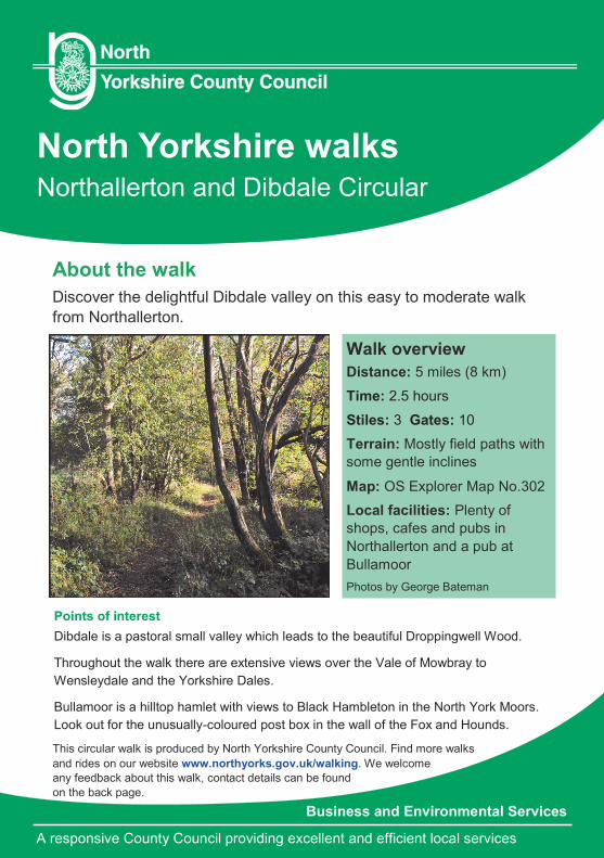
North Yorkshire walks Northallerton and Dibdale Circular
About the walk
Discover the delightful Dibdale valley on this easy to moderate walk
from Northallerton.
Walk overview
Distance: 5 miles (8 km)
Time: 2.5 hours
Stiles: 3 Gates: 10
Terrain: Mostly field paths with
some gentle inclines
Map: OS Explorer Map No.302
Local facilities: Plenty of
shops, cafes and pubs in
Northallerton and a pub at
Bullamoor
Photos by George Bateman
This circular walk is produced by North Yorkshire County Council. Find more walks
and rides on our website www.northyorks.gov.uk/walking. We welcome
any feedback about this walk, contact details can be found
on the back page.
Points of interest
Dibdale is a pastoral small valley which leads to the beautiful Droppingwell Wood.
Throughout the walk there are extensive views over the Vale of Mowbray to
Wensleydale and the Yorkshire Dales.
Bullamoor is a hilltop hamlet with views to Black Hambleton in the North York Moors.
Look out for the unusually-coloured post box in the wall of the Fox and Hounds.
North Yorkshire County Council Business and Environmental Services
2
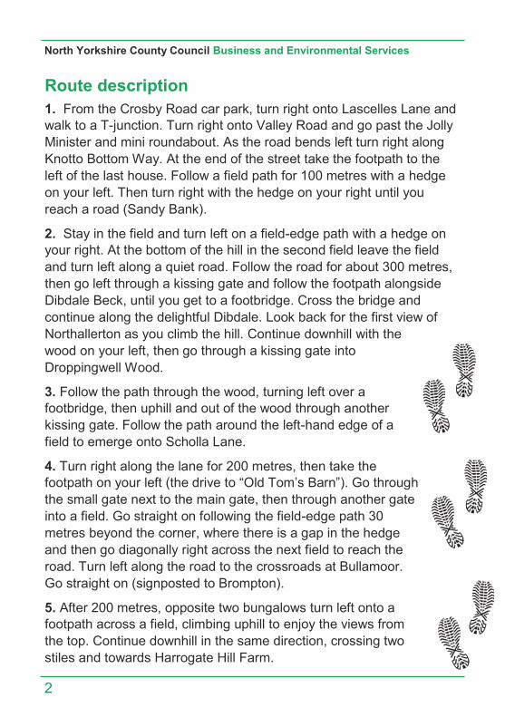
Route description
1. From the Crosby Road car park, turn right onto Lascelles Lane and
walk to a T-junction. Turn right onto Valley Road and go past the Jolly
Minister and mini roundabout. As the road bends left turn right along
Knotto Bottom Way. At the end of the street take the footpath to the
left of the last house. Follow a field path for 100 metres with a hedge
on your left. Then turn right with the hedge on your right until you
reach a road (Sandy Bank).
2. Stay in the field and turn left on a field-edge path with a hedge on
your right. At the bottom of the hill in the second field leave the field
and turn left along a quiet road. Follow the road for about 300 metres,
then go left through a kissing gate and follow the footpath alongside
Dibdale Beck, until you get to a footbridge. Cross the bridge and
continue along the delightful Dibdale. Look back for the first view of
Northallerton as you climb the hill. Continue downhill with the
wood on your left, then go through a kissing gate into
Droppingwell Wood.
3. Follow the path through the wood, turning left over a
footbridge, then uphill and out of the wood through another
kissing gate. Follow the path around the left-hand edge of a
field to emerge onto Scholla Lane.
4. Turn right along the lane for 200 metres, then take the
footpath on your left (the drive to “Old Tom’s Barn”). Go through
the small gate next to the main gate, then through another gate
into a field. Go straight on following the field-edge path 30
metres beyond the corner, where there is a gap in the hedge
and then go diagonally right across the next field to reach the
road. Turn left along the road to the crossroads at Bullamoor.
Go straight on (signposted to Brompton).
5. After 200 metres, opposite two bungalows turn left onto a
footpath across a field, climbing uphill to enjoy the views from
the top. Continue downhill in the same direction, crossing two
stiles and towards Harrogate Hill Farm.
North Yorkshire walks
3
Route description continued
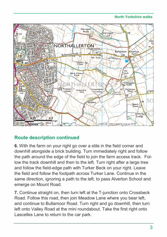
6. With the farm on your right go over a stile in the field corner and
downhill alongside a brick building. Turn immediately right and follow
the path around the edge of the field to join the farm access track. Fol-
low the track downhill and then to the left. Turn right after a large tree
and follow the field-edge path with Turker Beck on your right. Leave
the field and follow the footpath across Turker Lane. Continue in the
same direction, ignoring a path to the left, to pass Alverton School and
emerge on Mount Road.
7. Continue straight on, then turn left at the T-junction onto Crossbeck
Road. Follow this road, then join Meadow Lane where you bear left,
and continue to Bullamoor Road. Turn right and go downhill, then turn
left onto Valley Road at the mini roundabout. Take the first right onto
Lascelles Lane to return to the car park.
How to get there...
By Car: From A1 follow A19/A168 to
Northallerton. Start Grid Ref. SE 372 939.
Parking: Parking in Crosby Road car park
Northallerton. Grid Ref. SE 372 939.
Train: Northallerton Station - National Rail
Enquiries: 08457 484950.
Bus: Traveline 0871 2002233.
Walk your way to a
healthier lifestyle.
Walking one mile burns virtually the same number of calories as jogging a mile, it just takes a little longer!
Walking is FREE and requires no special equipment or clothing.
Regular walking helps reduce the risk of heart disease, strokes, diabetes and high blood pressure.
Always follow
The Countryside Code
• Be safe - plan ahead and
follow any signs
• Keep dogs under close
control
• Prevent uncontrolled
moorland fires
• Protect plants and
animals, and take your
litter home
• Leave gates and
property as you find
them
• Consider other people Contact us
North Yorkshire County Council, County Hall,
Northallerton, North Yorkshire, DL7 8AD
Our Customer Service Centre is open Monday to
Friday 8.00am - 5.30pm (closed weekends and
bank holidays). Tel: 01609 780 780
email: [email protected]
www.northyorks.gov.uk/paths or you can
access all North Yorkshire County Council
information online at: www.northyorks.gov.uk
If you would like this information in
another language or format such as
Braille, large print or audio, please ask us.
Tel: 01609 780 780
Email: [email protected]
Public footpath can be used by walkers.
Waymarked with a yellow arrow.
Public bridleway can be used by
walkers, horse riders and cyclists.
Waymarked with a blue arrow.
Restricted byway can be used by
walkers, horseriders, cyclists and non
motorised vehicles. Waymarked with a
purple arrow.
Byway open to all traffic (BOAT) can
be used by walkers, horse riders, cyclists
and motor vehicles. Waymarked with a
red arrow.
This walk guide was developed
in partnership with members of
the Ramblers - Northallerton
Group.
www.northallertonramblers.org.uk