Embed Size (px)
Citation preview
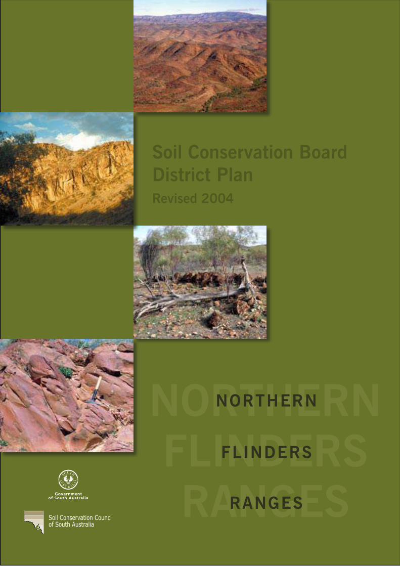
NORTHERNFLINDERSRANGESRANGES
Soil Conservation BoardDistrict PlanRevised 2004
NORTHERN
FLINDERS

FOREWORD The Northern Flinders Soil Conservation Board has been involved in various activities since the inception of our first District Plan, which was completed in 1997. Most of the activities that we pursued since that time have been carried out or on-going.
Several new projects have been completed, namely the Aroona Dam Biodiversity Enhancement Project. This project has seen the construction of two walking trails, interpretive signage, feral animal control including goats, foxes and cats, as well as a comprehensive destruction of rabbit warrens and land rehabilitation.
Another project was a Pilot Programme, which involved local landholders, Animal Plant Control Commission and NPWSA in a range of activities including weed control, feral animal control and land rehabilitation. This integrated with the NPWSA Bounceback Programme in feral goat control, donkey control and 1080 baiting for foxes. Some projects undertaken by landholders were rabbit warren destruction, water point relocation, land rehabilitation and water ponding to name just a few.
The Northern Flinders Soil Conservation Board has also become involved with a Regional Soil Board Executive, which has sourced funding from N.H.T. grants from the Commonwealth Government. Most of this funding is on a 50/50 basis and has met with approval from landholders throughout the Soil Board region.
The proposed Natural Resources Management Act has yet to be legislated and further meetings are planned before it will become law. There are a number of concerns by Boards in the Rangelands of South Australia not the least of which is the ongoing funding of these proposed groups and the people who will drive them.
Many issues are ongoing, but funding is vital. Without adequate funding and the commitment of both State and Federal Governments, feral animal and noxious weed control and land rehabilitation could grind to a halt, thereby undoing much of the hard slog that the Soil Board has committed itself to over the past 14 years.
Total commitment from ALL participants will ensure that the biodiversity of the region is maintained and enhanced.
John Mengersen
CHAIR, NORTHERN FLINDERS RANGES
SOIL CONSERVATION BOARD
ABBREVIATIONS
COAG Council of Australian Governments DEH Department of Environment and Heritage, South Australia DWLBC Department of Water, Land and Biodiversity Conservation GIS Geographic Information System ICM Integrated Catchment Management INRM Integrated Natural Resource Management NHT Natural Heritage Trust. NLWRA National Land and Water Resources Audit NPWSA National Parks and Wildlife, South Australia. NRDB Northern Regional Development Board. NRM Natural Resource Management PIRSA Primary Industries and Resources, South Australia. PMIS Pastoral Management Information System, maintained by the Pastoral
Program in DWLBC. RAP Rangeland Action Project. RCD Rabbit Calici Virus, a viral disease which only affects European
Rabbits. This disease has spread throughout most of Australia where rabbits occur, since its escape from Wardang Island in October 1995.
RHD Rabbit Hemorrhagic Disease – alternative name for above, relates
specifically to the disease, which results from the virus. RSBEX Rangeland Soil Board Executive Committee, formed in 1998, initially to
produce the Rangelands Regional Strategy. Made up of Chairpersons (or their representatives) from the seven rangeland soil boards. Currently also responsible for managing the RAP.
RSSA Rural Solutions South Australia, an agricultural consulting business
unit within PIRSA. SB Soil Boards, full name is Soil Conservation Boards. SAMLISA Strategy for Aboriginal Managed Lands in South Australia. SSIR Supporting Sustainable Industries in the Rangelands. SRRP Southern Rangelands Rural Plan. TSA Transport SA
Northern Flinders District Plan

GLOSSARY AEOLIAN Wind blown deposits.
ALLUVIAL SOIL A soil developed from Alluvium.
ALLUVIUM An extensive stream laid deposit which may include gravel, sand, silt and clay. Typically forming floodplains that develop alluvial soils.
ANNUAL PLANT Plants which germinate, flower and seed in one season or year, eg. button grass, fairy grass. (See perennial plant).
ARID Refers to climates or regions, which lack sufficient rainfall for crop production or extensive sown pastures. Usually defined as a climate with annual average rainfall less than 250 mm (10 inches).
BRUMBY Feral horse.
CARRYING CAPACITY An estimation of the long term stocking rate land can support without a decline in the sustainability or condition of the vegetation and soil resource.
CHENOPOD A plant which is a member of the drought and salt tolerant Chenopodiaceae family (e.g. saltbush, bluebush, bindyi).
CONDITION The condition or 'health' of plant and soil resources, relative to their potential. Condition is determined by comparing similar sites under different grazing impacts.
CONDITION TREND The trend in condition or 'health' of the soil and plant resource as determined by monitoring. The trend could be described as stable, declining or improving.
COVER The proportion of ground surface covered by plants, litter and stone (usually expressed as a percentage). Cover is one of the most important factors in reducing soil erosion.
DECREASER PLANTS Plants which are preferred by stock and which decrease in density and are eventually eliminated from zones of high grazing pressure. Bladder saltbush and Mitchell grass are decreaser plants. (See indicator plants, increaser plants).
DEGRADATION Degradation of land is the decline in the quality of the natural resources of the land resulting from human activities on the land.
DESTOCKING The removal of stock from a grazing area, generally to reduce the grazing pressure on the area and often to provide the vegetation in the area an opportunity to resprout, seed or recruit.
DOG FENCE Vermin proof fence designed to keep dingoes out of the sheep country.
The idea of a continuous fence running from the NSW border to the Great Australian Bight was formalised in 1946 by the Dog Fence Act, which also established the Dog Fence Board to administer, patrol and organise maintenance of the fence.
A new system is currently being put in place where pastoralists are no longer required to maintain their sections of the Dog Fence. Local Dog Fence Boards were recently set up to undertake the day to day management of the various sections of the fence in South Australia. Contractors to these Local Boards, for maintenance and monitoring, conduct fortnightly patrols.
A fence supervisor inspects the entire 2,230 km four times per year. The cost of maintaining the Dog Fence in South Australia is met through a levy on all property holdings larger than 10 km2 south of the fence and is subsidised dollar for dollar by the State Government.
DIRECT SEEDING Application of seed directly into the area in which the seedlings are to germinate and grow to maturity.
DISPERSABLE SOIL A structurally unstable soil which readily disperses into its constituent particles (clay, silt, sand) in water. Highly dispersible soils are normally highly erodible. (See soil erodibility).
DOMINANT SPECIES The tallest plant species present at a site. There must be several individuals of the plant present at the site for it to be the dominant species.
DUPLEX SOIL A soil in which there is a sharp change in soil texture between the A horizon (topsoil) and B horizon (subsoil). In the pastoral areas these soils are common and are prone to scalding.
ECOLOGY The study of relationships between living organisms and their environment.
EXCLOSURE An area of rangeland from which domestic and / or feral or native animals are excluded for the purposes of studying the effects of grazing on vegetation. Such an area may range in size, however exclosures established by the Pastoral Management Branch are normally in sets of 3, each 50 x 50 meters. One exclosure is stock, rabbit and kangaroo proof; the second exclosure is stock and kangaroo proof, and the third area is the control and is marked and measured but not fenced.
GILGAI Micro-relief associated with some clayey soils consisting of depressions and / or hummocks of varying size, shape and frequency. Gilgai depression formation and / or maintenance is a continuing long-term process in which the shrinking and swelling of deep subsoils with changes in moisture content causes the redistribution of soil. ‘Gilgai’ is an aboriginal word meaning small waterhole.
GRADATIONAL SOIL A soil in which there is a gradual change in soil texture from the A horizon (surface soil) to the B & C horizons (subsoil).
GROUND COVER Material which protects the soil from erosion. Ground cover can include plants, stone, plant litter and lichen.
Northern Flinders District Plan

GULLIES An open incised erosion channel in the landscape greater than 30 cm deep. The main factor contributing to the formation of gullies is the concentration of surface runoff; gullies are often associated with drainage lines.
GYPSUM A naturally occurring soft crystalline material containing approximately 23% calcium and 18% sulphur. Gypsum is commonly used to improve soil structure and reduce crusting in hard setting clays.
HUMMOCKING The mounding of windblown material at the base of plants. See soil erosion (wind erosion).
INCREASER PLANTS Plants which are not preferred by stock for grazing and which increase in density and eventually dominate zones of high grazing pressure (replacing decreaser plants). Poverty bush, silvertails and sandhill wattle can be increaser plants in some situations. (See invader plants, weeds, indicator plants).
INDICATOR PLANTS Plants of which can be used to indicate levels of range condition through their occurrence or abundance for a particular soil - vegetation association. (See increaser plants, decreaser plants).
INFILTRATION The downward movement of water into the soil. Factors affecting infiltration include soil structure, soil surface and plant density.
INVADER PLANTS Plants which establish, and subsequently dominate, sites on which they were formerly scarce or absent. The invasion usually occurs after, or as a result of, soil disturbance, for example, vegetation clearance, fire or high grazing pressure. (See increaser plants, undesirable plants).
LAND CAPABILITY The ability of land to sustain a type and intensity of use permanently, or for specified periods under specific management.
LAND CONDITION INDEX An index which provides an objective estimate of the relative overall condition of all the leases in a Soil Conservation Board District. (Previously known as the Weighted Average Condition (WAC) index). A manual developed for each Soil Conservation District which provides criteria and photographic standards for assessing the condition (good, fair, poor) of each pasture type and component within the district.
LAND SYSTEM An area of land distinct from surrounding areas with a relatively uniform climate and throughout which there is a recurring pattern of topography, geology, soils and vegetation. Land systems are most commonly delineated on a map. (See land unit, vegetation association).
LAND UNIT An area with uniform landform, geology, soils, and vegetation. A land unit may occur repeatedly at similar points in the landscape over a defined region. A land unit is a constituent part of a Land System. (See vegetation association)
MECHANICAL REHABILITATION The rehabilitation of degraded land using mechanical implements such as opposed disc ploughs and pitter planters.
MONITORING Collection and comparison of information to determine type, extent and cause of change.
PASTURE COMPOSITION The species and proportion of each species present in the pasture. Pasture species composition can change in response to grazing, fire or seasons. Undesirable changes may include a shift from perennial to annual species, or from palatable to less palatable species, or an increase in the proportion of woody shrubs and / or weeds in the pasture (see increaser plants and decreaser plants). If an undesirable change in species composition is thought to be the result of grazing, it is referred to as vegetation degradation.
PEDESTALLING The removal of soil from the base of a plant exposing the roots. Often a result of wind and stream-bank erosion.
PENEPLAIN Level to gently undulating landform pattern with extremely low relief and sparse slowly migrating alluvial stream channels, which form a non-directional, integrated tributary pattern. It is eroded by barely active sheet flow, creep, and channeled and over-bank stream flow.
PERENNIAL PLANT A plant whose life cycle extends for more than two years (e.g. bladder saltbush). Some perennials, such as grasses and herbs, have above-ground parts, which die off in unfavorable seasons leaving an underground structure, such as a bulb or rhizome, to produce new growth when the season is favourable, (e.g. Mitchell grass). (See annual plant).
PHOTOPOINT A photopoint is a marked site from which photographs are taken to monitor change over time. Photopoints are set up as part of the pastoral lease assessment process. At these sites vegetation condition is usually also monitored.
PHYTOTOXIC Poisonous to plants.
PIONEER PLANTS Plants which colonise bare or disturbed areas.
PIOSPHERE The zone of altered vegetation density and composition resulting from stock pressure associated with a water point. (Pio = water)
PLANT DENSITY The number of plants in a defined area. Usually expressed as plants per unit area.
RANGELAND Land used for extensive grazing of sheep, cattle or other domestic stock. Rangeland vegetation is typically native or naturalised pasture and the country in general does not have the capability to sustainably support the economic production of crops. (See land capability, sustainable use).
RANGELAND CONDITION Describes the current condition of rangeland in relation to the potential condition of the particular area for the extensive grazing of domestic stock. (See condition trend, sustainable use).
RE-ASSESSMENT When used by the Pastoral Management Branch refers to monitoring of established monitoring sites (photopoint sites), determining a Land Condition Index for a lease and making comments regarding the condition of the land subsequent to the initial lease assessment required under the Pastoral Land Management and Conservation Act 1989.
Northern Flinders District Plan

REFERENCE AREA A reference area is an area of land representing a particular pasture type, which is used to separate the effect of the grazing of stock from that of climate / season. Some reference areas include exclosures which are used to separate the effect of the grazing of stock from that of feral animals. The Pastoral Land Management and Conservation Act 1989 provides for the establishment of reference areas and specifies that they will not be greater than 1 km2.
REGENERATION The re-establishment of native pastures by self-seeding and growth.
REHABILITATION The treatment of degraded or disturbed land to achieve an agreed level of capability and stability, preferably at least equal to that which existed prior to degradation or disturbance. Rehabilitation may involve cultivation, earthworks, direct seeding etc. (See mechanical rehabilitation, land capability.)
REVEGETATION The re-establishment of plants on an area where the vegetation has previously been depleted, often to provide protection against soil erosion. (See regeneration, direct seeding.)
ROBUSTNESS INDEX A number calculated from the Land Condition Index for each lease which gives an indication of the ability of the land in the lease to sustainably carry stock compared with other leases in the District.
RUNOFF The portion of precipitation not absorbed into or detained upon the soil and which becomes surface flow.
SCALD A bare area produced by the removal of the surface soil by wind and / or water erosion or salination. The result is exposure of the more clayey subsoil which is, or becomes, relatively impermeable to water. Scalds are a typical erosion form of duplex soils in the semi-arid and arid regions. Scalds are difficult to revegetate due to the lack of topsoil, low permeability, and often saline surface.
SEMI-ARID Refers to climates or regions which lack sufficient rainfall for regular crop production. Usually defined as a climate with annual rainfall greater than 250 mm but less than 375 mm.
SOIL EROSION The detachment and transportation of soil and its deposition at another site by wind, water or gravitational effects.
Natural erosion Erosion occurring under natural environmental conditions, undisturbed by humans. Accelerated erosion Erosion which is attributable to the influence of human activities. See also scald, hummocking and pedestalling. Water erosion An erosion process in which soil is detached and transported from the land by the action of rainfall, runoff and seepage. Types of water erosion include:
Splash erosion The spattering of soil particles caused by the impact of raindrops on the soil; an important component of sheet erosion.
Sheet erosion The removal of a fairly uniform layer of soil from the land surface by wind and raindrop splash and /or runoff. No rills are formed.
Rill erosion The removal of runoff from the land surface whereby numerous small channels are formed. Rills are defined as small channels up to 30 cm deep.
Gully erosion The removal of soil by water whereby large incised channels (> 30 cm deep) are formed. The severity of gully erosion may be recorded as minor, moderate, severe or very severe. Gully erosion processes may include the removal of soil from the land surface by concentrated runoff or the dispersion of unstable subsoils.
Stream bank erosion The removal of soil from stream banks by the direct action of steam flow and/or wind /wave action. Typically occurs during periods of high flow.
Wind erosion The removal and transportation of soil by wind. (See sheet erosion). SOIL ERODIBILITY The susceptibility of a soil to the detachment and transportation of soil particles by erosive agents.
Erodibility is a function of mechanical, chemical and physical characteristics. SOIL PROFILE A cross-sectional exposure of a soil, extending downwards from the soil surface to the parent material
(bedrock). A soil profile is generally composed of three major layers designated A, B and C horizons.
SOIL TEXTURE The coarseness (sand content) or fineness (clay content) of soil.
SOIL SURFACE CONDITION Refers to the stability or form of degradation of the soil.
STABILISING PLANTS Plants used for the stabilisation of areas which have been eroded or disturbed.
SUSTAINABLE USE The use of the resource, (eg. pastoral land), in such a manner that the productivity and quality of the resource is maintained indefinitely.
TEXTURE CONTRAST SOIL Texture contrast soils are soils with a sharp change in texture between the topsoil (A horizon) and the subsoil (B or C horizons). Topsoils are generally light sandy or loamy textured, and subsoils are clayey.
UNIFORM SOIL A soil in which there is little if any change in soil texture between the A (surface) and B (subsoil) horizons.
VEGETATION ASSOCIATION A stable plant community of definite composition presenting a uniform appearance and growing in more or less uniform habitat conditions.
VEGETATION CONDITION Refers to the condition, composition and density of the plants in an area. (See pasture composition, plant density).
WEED Plants growing out of place. In a pastoral context weeds may be undesirable plants or increaser species which grow where desirable or decreaser plants have been removed. (See increaser plants, invader plants).
WOODY WEEDS Trees or shrubs which have increased in density to a point where productivity or management is adversely affected. (See increaser plants, invader plants).
Northern Flinders District Plan
CONTENTS SUMMARY ...................................................................................................................................................................1
INTRODUCTION..........................................................................................................................................................2
THE NORTHERN FLINDERS RANGES SOIL CONSERVATION BOARD ............................................................2
DUTY OF CARE .....................................................................................................................................................2
ROLE OF THE BOARD ..........................................................................................................................................2
AIMS OF THE BOARD AND THE DISTRICT PLAN...............................................................................................3
COMMUNITY CONSULTATION.............................................................................................................................3
REVIEW..................................................................................................................................................................3
OTHER ACTS AFFECTING SOIL CONSERVATION AND LANDCARE................................................................3
DESCRIPTION OF THE DISTRICT .............................................................................................................................5
INTRODUCTION ....................................................................................................................................................5
CLIMATE ................................................................................................................................................................7
Winds...........................................................................................................................................................8
Rainfall.........................................................................................................................................................8
Meteorological drought ................................................................................................................................9
Potential evaporation ...................................................................................................................................9
Temperature ..............................................................................................................................................10
Frosts.........................................................................................................................................................10
Sunshine hours..........................................................................................................................................10
GEOLOGY............................................................................................................................................................11
Soil Types .................................................................................................................................................11
LAND SYSTEMS ..................................................................................................................................................15
WATER RESOURCES .........................................................................................................................................19
Surface water ............................................................................................................................................19
Groundwater ..............................................................................................................................................19
LAND USE HISTORY ...........................................................................................................................................20
Aboriginal cultural regions .........................................................................................................................20
Exploration.................................................................................................................................................20
Pastoralism................................................................................................................................................20
Farming .....................................................................................................................................................22
Mining ........................................................................................................................................................23
Transport ...................................................................................................................................................24
Communication..........................................................................................................................................25
PRESENT LAND USE ..........................................................................................................................................25
Pastoral .....................................................................................................................................................25
Tourism......................................................................................................................................................25
Conservation .............................................................................................................................................26
Flinders Ranges National Park ..................................................................................................................26
Mining ........................................................................................................................................................28
Agriculture .................................................................................................................................................28
Urban areas and infrastructure ..................................................................................................................29
Communication/Transport .........................................................................................................................29
LAND TENURE.....................................................................................................................................................29
Pastoral Lease...........................................................................................................................................29
Perpetual Lease.........................................................................................................................................30
Freehold Land ...........................................................................................................................................30
Indigenous Protected Areas ......................................................................................................................30
Miscellaneous Lease .................................................................................................................................30
Reserves ...................................................................................................................................................30
Unallotted Crown Land ..............................................................................................................................31
Mining and Mineral Extraction Lease.........................................................................................................31
THE DOG FENCE ................................................................................................................................................31
Northern Flinders District Plan

LAND MANAGEMENT .........................................................................................................................................32
LAND CAPABILITY...............................................................................................................................................32
RANGELAND CONDITION ..................................................................................................................................32
PASTORAL LAND MANAGEMENT......................................................................................................................33
Grazing management ................................................................................................................................33
Water .........................................................................................................................................................33
Water management plans..........................................................................................................................34
Feed ..........................................................................................................................................................34
Soil Type....................................................................................................................................................35
Rainfall.......................................................................................................................................................35
PROPERTY PLANNING ......................................................................................................................................35
Fencing and distribution of water ...............................................................................................................35
Paddock size and shape............................................................................................................................36
Topography ...............................................................................................................................................36
Stock handling facilities .............................................................................................................................36
Managing for dry seasons .........................................................................................................................36
General stock management ......................................................................................................................37
PASTURE TYPES - PRODUCTION INDICATORS & CONSTRAINTS................................................................37
Chenopod shrublands – saltbush and bluebush country ...........................................................................37
Annual pasture ..........................................................................................................................................39
Mitchell grass country ................................................................................................................................40
Scrub country ............................................................................................................................................41
Woodlands.................................................................................................................................................41
PASTORAL LEASE ASSESSMENT.....................................................................................................................42
MINING AND EXPLORATION..............................................................................................................................43
Abandoned mines......................................................................................................................................43
Working mines...........................................................................................................................................43
New mining projects ..................................................................................................................................44
Resource exploration.................................................................................................................................44
AGRICULTURE AND HORTICULTURE...............................................................................................................44
POTENTIAL ALTERNATIVE LAND USES ...........................................................................................................45
Agriculture and horticulture........................................................................................................................45
Tourism and recreation..............................................................................................................................46
Rubbish disposal .......................................................................................................................................46
Public Access ............................................................................................................................................46
Education...................................................................................................................................................46
BIODIVERSITY ....................................................................................................................................................47
Management..............................................................................................................................................49
RABBITS ..............................................................................................................................................................50
Control .......................................................................................................................................................51
FERAL GOATS.....................................................................................................................................................53
Control .......................................................................................................................................................53
OTHER FERAL ANIMALS ....................................................................................................................................54
NATIVE GRAZING ANIMALS...............................................................................................................................54
Kangaroos .................................................................................................................................................54
Emus .........................................................................................................................................................57
Insects .......................................................................................................................................................57
SCALDING ...........................................................................................................................................................57
WIND EROSION...................................................................................................................................................58
WATER EROSION ...............................................................................................................................................58
FIRE......................................................................................................................................................................59
INTRODUCED WEEDS........................................................................................................................................59
WOODY SHRUB INCREASE ...............................................................................................................................61
Northern Flinders District Plan

INFRASTRUCTURE CONSTRUCTION AND MAINTENANCE............................................................................61
CULTURAL HERITAGE .......................................................................................................................................62
Aboriginal heritage and culture ..................................................................................................................62
Heritage of early settlers and explorers .....................................................................................................62
PROPERTY MANAGEMENT PLANNING............................................................................................................62
REVIEW OF THREE YEAR PLAN & NEW PLAN ................................................................................................64
REFERENCES .....................................................................................................................................................67
APPENDIX 1 – Historical rainfall records for selected stations.............................................................................68
APPENDIX 2 – Mean and median rainfall for selected stations............................................................................71
APPENDIX 3 – Rainfall deciles for selected stations............................................................................................72
APPENDIX 4 – Temperature data for Andamooka, Leigh Creek & Hawker .........................................................74
APPENDIX 5 – Scientific and common names of plants referred to in the district plan ........................................75
APPENDIX 6 – Weed identification form ..............................................................................................................79
Northern Flinders District Plan

LIST OF FIGURES Figure 1 Location of the Northern Flinders Ranges Soil Conservation District ......................................... 5
Figure 2 The Average Mean Sea Level Pressure Pattern For Mid-Season Months ................................. 7
Figure 3 The Geology of the Northern Flinders Ranges Soil Conservation District ................................ 12
Figure 4 The Land Systems of the Northern Flinders Ranges SCD ........................................... 13 and 14
LIST OF TABLES Table 1 Extreme Daily Rainfalls Recorded at Selected Stations ............................................................. 9
Table 2 Average Monthly Potential Evaporation Estimates for Mid-Season Months ............................. 10
Table 3 Management of Mining Operations for Environmental Sustainability........................................ 44
Table 4 Agricultural and Horticultural Land Management ...................................................................... 45
Table 5 Kangaroo Densities and Estimated Populations from DEH Survey Data .................................56
Northern Flinders District Plan

Northern Flinders District Plan SUMMARY
SUMMARY
The Northern Flinders Ranges Soil Conservation District is located between 320 and 560 kilometres north of Adelaide. The most extensive land use in the District is the grazing of sheep and cattle on native pastures. Cropping is carried out in a small area in the south, near Hawker. Coal extraction is carried out at Leigh Creek and uranium mine is located at Beverley. The Flinders Ranges and Vulkathunha-Gammon Ranges National Parks are within the District, and there are a variety of tourist facilities provided, making tourism a major land use in the area.
The area is one of the most environmentally diverse and scenic in South Australia. It includes rugged, mountainous areas, grasslands, land dominated by saltbush and bluebush, sandy dune - swale systems and watercourses lined with river red gums and/or melaleucas.
The Northern Flinders Ranges has an arid climate, with hot dry summers and cool to mild winters, generally with low annual rainfall. The ranges have an important influence on rainfall, increasing the average from below 200 mm on the plains to more than 300 mm over the higher parts of the range.
There are a few springs which feed creeks and provide near-permanent waterholes which are important for domestic and stock use, tourism and native animals. Dams are a significant part of the water supply network for domestic and stock use on stations but pumped groundwater is the primary water source of the pastoral industry in the District.
Land management issues in the District include managing total grazing pressure, managing mining operations, conserving biodiversity, prevention of accelerated soil erosion and rehabilitation of affected areas, fire management and weed control.
The Northern Flinders Soil Conservation Board is committed to promoting and encouraging the management of the District’s natural resources according to world’s best practice.
1

North Flinders District Plan INTRODUCTION
INTRODUCTION
THE NORTHERN FLINDERS RANGES SOIL CONSERVATION BOARD
The Northern Flinders Ranges Soil Conservation Board is a body corporate constituted under the Soil Conservation and Land Care Act 1989. The Board is made up of seven land managers from within the District who are committed to promoting soil conservation in the context of productive land use. The Minister for Environment
(John Hill) appoints board members for a three-year term. Six members must live within the District and have suitable knowledge and experience in land management. The seventh member has been nominated from National Parks and Wildlife SA in DEH.
The members of the 2004 Board are:
Name and Role Location and Phone number
John Mengersen (Chairperson) Depot Springs Station, 86752553
Donald Fels (Secreary/Treasurer) Merna Mora Station, 86484717
John (Jack) Shute (Local Government) Hawker, 86484210
Roger Johnson (Member) Nepabunna, 86483701
Peter McInnis (Member) Wonoka Station, 86484035
Leonard Nutt (Member) Edeowie Station, 86484714
Nicki DePreu (National Parks) Hawker, 86484244
Members of previous Boards are Richard Warwick, Beat Odermatt, Judith Nutt, Phillip Spiers, Daryl Wanke, Phil Strachan, Warren Fargher, Brent Williams, Dean Rasheed, John Spiers, Keith Wiseman, Jim Best, Tom Flynn, Douglas Sprigg, Cathy Zwick, Vincent Coulthard, Ian Shute and Heather Snelling.
DUTY OF CARE The Board feels it is the responsibility of all land users whether land managers or visitors to care for the land.
The Soil Conservation and Land Care Act 1989 provides that it is the duty of all landholders to take all reasonable steps to prevent degradation of the land. Degradation of land means a decline in the quality of soil, vegetation, water and other natural resources of the land resulting from various activities, or failure to take appropriate action.
ROLE OF THE BOARD The role of the Board is to:
• develop community awareness and understanding of land conservation issues;
• promote the principle that land must be used within its capability;
• develop and support community projects for land conservation and rehabilitation;
• provide advice and assistance to landholders on land conservation and rehabilitation;
• seek landholder cooperation to ensure land is not degraded;
• prepare District Plans, Three-Year Programs and approve property plans; and
• implement the provisions of the Soil Conservation and Land Care Act 1989.
2
Northern Flinders District Plan INFORMATION
AIMS OF THE BOARD AND DISTRICT PLAN
The aim of the Board and District Plan is to provide guidelines for sustainable land management and environmental care by landholders, residents and visitors. The Board aims to encourage the integrated conservation and protection of natural resources such as soils, vegetation, wildlife and water with human activities such as grazing, mining and recreation.
The Board supports the concept of multiple land use which ensures care for all natural resources by environmentally responsible management of infrastructure, business enterprises and recreational facilities.
The Board actively encourages the monitoring and surveillance of land condition.
This District Plan describes the District including its land systems, land capability, land uses and existing and potential soil and vegetation degradation problems.
The Board, through this District Plan, aims to assist the implementation of land management practices which will protect the diversity and density of vegetation, protect soils from erosion, improve the vegetation of degraded lands and safeguard the long term productivity of the land.
A Three-Year Program, (including a review of the previous 3 year plan) which outlines the Board’s proposed objectives and activities for the management of natural resources and promotion of the land care ethic is also included in this Plan.
COMMUNITY CONSULTATION This review of the District Plan has been prepared by the Board with the comments of local land managers in mind. This document has been released in draft form for a 90-day period during which comments on its content were sought from the community.
REVIEW This District Plan will be reviewed on a regular basis, when concerns and guidelines presented in this Plan will be updated. Ongoing consultation with the
community is recognised by the Board as necessary to maintain the relevance of this Plan and the Board’s activities to the current natural resource management issues within the District.
This plan has been reviewed in consideration of the imminent changes to Soil Conservation, Water Resources and Animal and Plant Control legislation and the introduction of integrated management of natural resources within the state and the rangelands specifically. All effort has been made to ensure that this plan is consistent with these changes and also with other current planning initiatives such as the Water Management Plan for the North East, Flinders and Gawler Ranges and the proposed Integrated Natural Resources Management Plan and Investment Strategy.
OTHER ACTS AFFECTING SOIL CONSERVATION AND LAND CARE
The North Flinders Soil Conservation Board is a prescribed body under the Animal and Plant Control Act 1983. This means that the board has a role in: -
Raising awareness of animal and plant control issues
Identifying animal and plant control priorities (in the District Plan)
Determining in liaison with the Animal and Plant Control Commission what action is required.
The Water Resources Act 1997, has resulted in the formation of the Arid Areas Water Catchment Management Board, which is responsible for the management of water resources (ground and surface) in the out of hundreds area of the state. Its role is to develop water management plans for the area. These will be consistent with the Soil Board district plans and any other relevant plans and legislation.
The Natural Resource Management Act 2004 will repeal the Animal and Plant Control Act 1983, the Water Resources Act 1997
3

Northern Flinders District Plan INFORMATION
and the Soil Conservation and Land Care Act 1989.
Much of the District is Pastoral Lease held under the Pastoral Land Management and Conservation Act 1989. This Act limits land uses on pastoral leaseholds almost solely to grazing specified stock on native pastures.
Flinders Ranges National Park, Vulkathunha-Gammon Ranges National Park, and Lake Torrens National Park are dedicated under the National Parks and Wildlife Act 1972. While this Act may not necessarily limit the applicability of the Soil Conservation and Land Care Act 1989, control of activities on reserve lands falls normally under the National Parks and Wildlife Act 1972. Most reserves dedicated for conservation purposes as the main land use, either possess or require a management plan under the National Parks and Wildlife Act 1972 (including amendments to Act and schedules), and come under the direct control of the National Parks and Wildlife (NPWSA)
The Commonwealth Environmental Protection and Biodiversity Conservation Act 1999 aims to provide for the protection of the environment, especially those aspects of the environment that are matters of national environmental significance. Under the assessment and approval provisions of the EPBC Act, actions that are likely to have significant impact on national environmental assets (Nationally Threatened species/communities, RAMSAR wetlands) are subject to a rigorous assessment and approval process.
Other acts that impinge on soil conservation are those covering exploration for oil and gas, and minerals. The Mining Act 1971, the Petroleum Act 2000, all provide for specific soil conservation and land care measures as part of exploration and operation. Activities under these Acts are also required to meet the objectives of the Soil Conservation and Land Care Act 1989. Also, the Development Act 1993, through its provision for Environmental Impact Statements (EIS), and the Environment Protection Act 1993 may provide another level of required protection for some developments.
Whilst the Soil Conservation Board has no specific role in these Acts, matters may arise which come under the Board's responsibility, and the mining and related Acts require that activities also conform to the Soil Conservation and Land Care Act 1989. The Board has a more clearly defined direct role in the management of lands under pastoral land use; hence the emphasis within this District Plan tends frequently to be on pastoral land uses. However, the Board can be used as a forum for consultation where conflicts arise.
The Soil Board recognises and acknowledges that there may be
changes to these or any other legislation, including the introduction of new legislation, which may affect
soil conservation and landcare, during the review period of this plan.
4

Northern Flinders District Plan INFORMATION
Figure 1 Location of the Northern Flinders Ranges Soil Conservation District.
5

Northern Flinders District Plan DESCRIPTION OF THE DISTRICT
DESCRIPTION OF THE DISTRICT
INTRODUCTION The Northern Flinders Ranges Soil Conservation District is 33,511 km2 and is located between 320 and 560 km north of Adelaide (Figure 1). The District is bounded by the Dog Fence to the north and east, Lake Torrens to the west and to the south by the hundreds of Barndioota, Wonoka, Wirreanda and Yednalue and Holowiliena South and Baratta Stations.
The towns of Hawker, Cradock, Leigh Creek, Copley, Blinman, Nepabunna, Parachilna and Lyndhurst provide services within the District.
The most extensive land use in the District is the grazing of sheep and cattle on native pastures. Cropping is carried out in a small area in the south of the District and coal extraction is a major industry at Leigh Creek. Tourism is a growing industry and is increasing in its economic contribution to the district, second only to mining in terms of economic returns.
Leigh Creek and Hawker provide the only hospital facilities in the District while the Royal Flying Doctor Service provides
medical clinics and evacuation in emergencies.
There are schools at Leigh Creek and Hawker; and the Open Access College provides for children on stations and in small communities. A regular school bus to Leigh Creek services the Nepabunna community.
TAFE provides training courses at the Leigh Creek campus.
The Northern Flinders Ranges Soil Conservation District is one of the most environmentally diverse regions within South Australia. It includes rugged mountainous areas, grasslands, land dominated by saltbush, alluvial plains, sandy dune / swale systems, and watercourses lined with river red gums and / or melaleucas.
The present vegetation and wildlife have been affected to varying degrees by human activities such as grazing, mining, exploration, agriculture, tourism, construction of roads and railways, and township development.
6

Northern Flinders District Plan DESCRIPTION OF THE DISTRICT
CLIMATE The Northern Flinders Ranges has an arid climate, with hot, very dry summers, cool to mild winters, and a low annual rainfall. Orographic uplift has an important influence on the climate, increasing the average annual rainfall from below 200 mm on the plains to more than 300 mm over the more elevated parts of the Ranges.
Seasonal variation in weather is influenced
by the location of the large-scale high-pressure systems which form part of the subtropical ridge (Fig. 2). During the warmer part of the year (December to March), the ridge is generally south of the District and the broad scale surface winds are from the southeast. During autumn, the ridge moves equator-wards and from June to September it generally lies north of the District, and the prevailing stream is westerly (northwest to southwest).
Figure 2 The average mean sea level pressure pattern for a) January, b) April, c) July, and d) October. The subtropical ridge (· - - ·), south of the continent in summer, moves northwards in April and is located just north of the Northern Flinders Ranges in July. (Source: National Meteorological Operations Centre, Bureau of Meteorology.)
7

Northern Flinders District Plan DESCRIPTION OF THE DISTRICT
Winds
While the prevailing airstream is determined by the large-scale pressure patterns that influence the area (Fig. 2), topography can have a marked influence on local wind speed and direction. This is particularly so overnight and in the early morning, when stable conditions enable localised wind regimes to be set up. For example, under certain atmospheric conditions, winds in the ‘lee’ of the range may be fresh to strong and quite blustery. Alternatively, under otherwise calm conditions, gentle down slope winds may occur overnight. During the day, hills and ridges may deflect the prevailing wind stream and shelter leeward localities.
In the period December to March winds are generally light to moderate (less than 30 kph) and the most frequent directions are from the eastern and southern quadrants. During the afternoon, winds typically turn more south to southwesterly.
From April to June winds are generally lighter and more variable, but the most frequent directions continue to be from the southeast and south quadrants.
From July to September winds during the day are generally fresher, and westerlies (northwest to southwest) prevail over most of the District. However the 9.00 am wind roses highlight the stable and frequently calm conditions which occur overnight.
Wind direction is more variable in October and November but northwest to southwest winds are most common during the day.
In general, the most frequent strong winds occur in the period from late winter through spring (August to November), while a ‘lull’ coincides with the subtropical ridge moving across the District in the period April to June. Gales (winds in excess of 62 kph) are infrequent, but are most likely from August to November.
Rainfall Rainfall in the Northern Flinders Ranges is highly variable, with the greatest variability in the lower rainfall areas. Average annual totals range from more than 300 mm along the South Flinders Ranges and on the Gammon Ranges, to below 200 mm at lower elevations. No seasonality is apparent in the northwest of the District, but in the south there is a weak winter rainfall maximum. Tables of monthly mean and median rainfalls, together with the mean number of rain days for selected stations, are in Appendix 2.
Widespread significant rainfall is infrequent. It is most likely to result from low level moist tropical inflow in summer, or from slow moving cut-off low pressure systems or north-west cloud bands, at any time of the year. The cloud bands, which originate over the tropical northeast Indian Ocean, are associated with moist north westerly flow aloft; but at the surface easterly, north easterly, or even light variable winds, may prevail. From May to September, falls may be supplemented along the South Flinders and occasionally on the Gammon Ranges, by rain or showers from frontal systems. Under extremely cold conditions, snow may also occur.
Rainfall in the warmer months is highly erratic, and most often in the form of heavy showers, associated with thunderstorms. Despite the seasonally dry conditions, it is at this time that extreme falls may be observed. Intrusion of copious moist air, associated with a trough of low pressure extending from the tropics can, in some years, produce prolonged periods of widespread rain. For example, in mid-March 1989, when a low pressure centre lay just to the north of the region, many places experienced record 24-hour falls well in excess of 200 mm, and many had record monthly falls, eg. Balcanoona had a monthly total of 676 mm. (Balcanoona’s median March rainfall is just 6 mm.) Extreme daily rainfalls for selected stations are shown in Table 1.
8

Northern Flinders District Plan DESCRIPTION OF THE DISTRICT
Station Station No. Highest daily fall (mm) Date Period of Record
Motpena Station 17098 273 14 Mar 1989 1969-1993
Nilpena 17113 247 14 Mar 1989 1973-1993
Balcanoona 17010 246 14 Mar 1989 1945-1993
Beltana Roadhouse 17119 236 14 Mar 1989 1986-1993
Commodore 17017 222 14 Mar 1989 1910-1993
Mt. Serle 17035 214 14 Mar 1989 1917-1991
Wilpena Chalet 19070 214 14 Mar 1989 1962-1993
Arkaroola 17099 190 30 Mar 1956 1938-1993
Warcowie 19046 189 13 Feb 1955 1872-1993
Wooltana 17056 188 16 Mar 1950 1877-1993
Hawker Post Office 19017 173 14 Mar 1989 1882-1993
Blinman 17014 158 14 Mar 1989 1874-1993
Erudina 20005 146 14 Mar 1989 1911-1993
Umbertana 17048 140 17 Mar 1950 1886-1993
Yednalue 19061 138 24 Dec 1919 1917-1993
Wilpena Head Station 19049 137 29 Jun 1939 1903-1985
Table 1 Extreme daily falls (9.00 am to 9.00 am) recorded at selected stations across the District. The Motpena Station extreme is the highest official daily rainfall recorded in South Australia.
The historical rainfall records for selected stations are graphed in Appendix 1. These graphs show:
• The annual and May to October totals for each year since records commenced;
• The median annual rainfall at each station (line M); and
• The lowest 10% of annual totals on record (line D).
The graphs highlight the year-to-year rainfall variability.
Annual and monthly decile tables for these stations are in Appendix 3. These tables can be used to estimate the probability (or chance) of rainfall totals exceeding a given threshold.
Meteorological drought The term drought refers to an acute water shortage. Although the amount of available water depends to a large extent upon storage (in the soil, in artesian basins and in dams and reservoirs) and in losses from evaporation, the best single indicator of water availability is rainfall. Gibbs and Maher (1967) showed that the years with an annual total in the first decile range (ie. the
lowest 10% of falls on record) correspond well with recorded droughts. Using this guide, and rainfall records from a number of stations, 12 years (since 1885) are identified as those in which drought affected extensive areas of the District. These years are 1888, 1902, 1927, 1928, 1929, 1935, 1940, 1943, 1944, 1948, 1967, 1982 and 2002.
The record shows that some of the more severe drought events have lasted up to two years or more, and that there are other periods of five years or so (eg. in the 1940s and 1960s), when large areas were affected by prolonged dry conditions interrupted only by brief, isolated rain events.
More rigorous methods of analysis, such as that used in Drought Review Australia, will identify slightly different drought periods to those identified above, including those of shorter duration.
Potential evaporation Evaporation is dependent on sunshine, temperature, humidity, wind and available water. For a given latitude, evaporation rates are generally lower on the Ranges, where cooler daytime temperatures occur.
9

Northern Flinders District Plan DESCRIPTION OF THE DISTRICT
On exposed ridges, persistently windy conditions can counter this effect.
Evaporation values used by the Bureau of Meteorology are based upon daily rates measured by a Class ‘A’ Evaporimeter (fitted with bird guard). These are potential evaporation values, as they represent the amount of evaporation possible, given an unlimited water supply. The values used in this climatology survey have been taken from evaporation analyses for South Australia, based on available records and compiled by the Bureau of Meteorology (1988).
Average annual evaporation ranges from 2500 mm in the south of the District to 3000 mm in the north. Table 2 shows the average monthly evaporation for the mid-season months. Mean monthly potential evaporation far exceeds the average monthly rainfall for all months.
January April July October
North 450 200 100 300
South 375 175 75 250
Table 2 Average monthly potential evaporation estimates for the mid-season months. Estimates are to the nearest 25 mm.
Temperature Daily maximum and minimum temperatures are influenced by elevation. On average, maximum temperatures will be reduced by around 1°C for every 100 m increase in elevation.
In the hotter part of the year (late November to March), in all but the higher regions (above an elevation of +400 m), mean maximum temperatures exceed 30°C. Daily temperatures over 40°C have been recorded in each month over most of the District between October and March. Average minimum temperatures for the period November to March are within a few degrees of 20°C at Leigh Creek (elevation 194 m), while at higher elevations, eg. At Wilpena Chalet (not shown, elevation 530.0 m) minima are generally in the low to mid-teens.
For the cooler months May to September, average maximum daily temperatures range
from near 20°C, down to the mid-teens in the coolest months, June and July. Average minimum temperatures are less than 10°C and fall to below 5°C in the Ranges from June to August. Minimum temperatures below zero have been recorded in each month between May and September in the Ranges, and from June to August at Leigh Creek.
Frosts Frosts occur in the cooler part of the year, generally on calm, clear nights when there is little moisture in the air. The frequency of frost is dependent on local surface features (including vegetation and soil moisture) and topography. Some locations, such as depressions, are more prone to frost occurrence than others are. Frost is reported when ice deposits are observed or when the ground surface temperature falls below minus 0.9°C, whether or not ice is observed. A minimum air temperature of less than 2.2°C is a good indicator of ground frost, and this criterion has been used to identify frost-days for this study. Actual observations of white frost (ice deposits) may occur less frequently. Air temperatures equal to or below zero indicate a heavy or severe frost.
In the ranges, frost-days have been observed as early as April and through to November, but the most frequent occurrence is from June to August. In this 3-month period, Arkaroola has, on average, 34, and Hawker 26, frost-days per year. At Leigh Creek frosts-days have been reported in all months from May to September but, again, are most common from June to August when, on average, 15 frost-days are observed.
Sunshine hours On an annual basis, the average number of hours per day of bright sunshine across the District is nine. This varies from an average of eleven hours per day in January to seven hours per day, on average, in July.
10

Northern Flinders District Plan DESCRIPTION OF THE DISTRICT
GEOLOGY There are two main types of geological formations in the Northern Flinders Ranges SCD;
• Hard rocks which form the ranges, and
• Sediments which infill broad shallow basins to form flat plains.
The hard rocks are very old (Adelaidian age) and were deposited between 500 million and 1,000 million years ago. Shallow seas covered the area at this time and a variety of sediments were laid down which were derived mostly from ancient mountain ranges on the Gawler Craton to the west. These sediments include fine-grained shales and siltstones, limestones and coarser grained sandstones, quartzites and conglomerates. The sediments were deposited in a deeply subsiding basin in thick and continuous layers, which have been compacted and hardened over millions of years. Despite being tilted and folded by crustal forces about 500 million years ago, these layers can still be traced for many kilometres (Figure 3). Block faulting about 50 million years ago had a major influence on today’s landscape by creating the highland of the Flinders Ranges and sedimentary basins to the east and west.
The sandstones and quartzites such as the ABC Quartzite are the most resistant to weathering and erosion and consequently form the most prominent hills and ranges such as Wilpena Pound and the Elder Range. On the other hand, the finer grained sediments such as shales and siltstones are softer and more easily weathered and eroded away. As a result, they form low hills or are completely concealed below ground level.
At the north-eastern extremity of the North Flinders in the Mount Painter area, lies an older group of basement rocks (1,850 to 1,000 million years old), which form rugged ranges and outcrops. These rocks were much more affected by heat and pressure (metamorphism) and much more deformed than the younger Adelaidian sediments. Rock types include gneiss schist, quartzite, granite and volcanic rocks
Sediments infill valleys between the ranges and underlie the broad plains to the east and west of the ranges. They are made up of clays, sands, and gravels, which are still soft and unconsolidated. They may vary in thickness from several metres to over 200 m in the Pirie - Torrens Basin to the west. There is also a considerable thickness of sediments in the Frome Embayment to the east of the ranges.
SOIL TYPES
The major soil types in the District are clay, kopi, sand, gibber, quartzite, dolomite, siltstone, conglomerate and gravel.
Most soil types in the Flinders Ranges have been created by years of erosion from the uplands to the plains and valleys on either side of the ranges.
Clay would have to be the dominant soil type over most of the Ranges with most plains and valleys interspersed with a combination of kopi and sedimentary soils containing a mixture of eroded rocks washed down from higher points.
There appears to be areas of kopi, which generally run parallel to the mountain ranges found in the Flinders Ranges.
11

Northern Flinders District Plan DESCRIPTION OF THE DISTRICT
Figure 3 Geology of the Northern Flinders Ranges Soil Conservation District.
12

Northern Flinders District Plan DESCRIPTION OF THE DISTRICT
Figure 4 Land Systems of the Northern Flinders Ranges Soil Conservation District.
13

Northern Flinders District Plan DESCRIPTION OF THE DISTRICT
14

Northern Flinders District Plan DESCRIPTION OF THE DISTRICT
LAND SYSTEMS The vegetation, soils, topography, and geomorphology of the Northern Flinders Ranges Soil Conservation District have been described by dividing the District into Land Systems. A Land System is an area, or group of areas throughout which there is a recurring pattern of geology, topography, soils, and vegetation.
The Land Systems and their component
units are described here, and a Land System map is presented in Figure 4.
The Land Systems described in this document were determined by combining the work of Laut et al. (1977), geological maps, satellite imagery and ground survey by staff of the Pastoral Program of DWLBC, the Flinders Ranges Management Review team and Roger Playfair.
Land System Descriptions
Alluvial Plains Arrowie Alluvial deposits and outwash plains;
very sparse prickly wattle flood outs, Mitchell grass plains with gilgais, low bluebush slopes and rises.
Arrowie Land System
Parachilna Stony outwash plains; sandy soils; prickly wattle and harlequin fuchsia bush over ward’s weed and copperburrs.
Saltia Alluvial footslopes and plains; stony red soils; bladder saltbush, low bluebush and scattered groves of black oak and prickly wattle.
Drainage areas Blanche Shallow salt lakes, sandy plains,
jumbled dunefields and sand mounds; saline and gypseous silts and clays; samphires and chenopod shrublands; nitrebush, canegrass, grass and forbs.
Blanche Land System
Plains Mumpie Undulating gibber tablelands with
gilgais; Mitchell grass, poverty bush and samphires with occasional cottonbush, dead finish and bladder saltbush.
Mumpie Land System
15
Northern Flinders District Plan DESCRIPTION OF THE DISTRICT
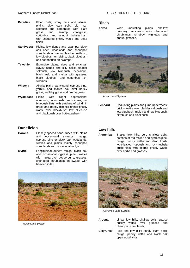
Paradise Flood outs, stony flats and alluvial plains; clay loam soils; old man saltbush and samphires with plate grass and swamp canegrass; cottonbush and harlequin fuchsia bush with scattered prickly wattle and dead finish.
Sandyoota Plains, low dunes and swamps; black oak open woodlands and chenopod shrublands on slopes; bladder saltbush, low bluebush on plains; black bluebush and cottonbush on swamps.
Telechie Extensive plains, rises and swamps; clayey sands and silty soils; bladder saltbush, low bluebush, occasional black oak and mulga with grasses; black bluebush and cottonbush on swamps.
Wilpena Alluvial plain; loamy sand; cypress pine, yorrell, and mallee box over barley grass, wallaby grass and brome grass.
Wyambana Plains with slight depressions; nitrebush, cottonbush run-on areas; low bluebush flats with patches of windmill grass and barley mitchell grass; prickly wattle over blackbush; low bluebush and blackbush over bottlewashers.
Dunefields Corona Closely spaced sand dunes with plains
and occasional swamps; mulga, cypress pine or black oak woodlands; swales and plains mainly chenopod shrublands with occasional mulga.
Myrtle Longitudinal dunes; mulga, black oak and occasional cypress pine; swales with mulga over copperburrs, grasses; chenopod shrublands on swales with heavier soils.
Myrtle Land System
Rises Anzac Wide undulating plains; shallow
powdery calcareous soils; chenopod shrublands, shrubby twin-leafs and annual grasses.
Anzac Land System
Lennard Undulating plains and jump-up terraces; prickly wattle over bladder saltbush and low bluebush; mulga and low bluebush; nitrebush and blackbush.
Low hills Alerumba Shaley low hills; very shallow soils;
patches of red mallee and cypress pine, mulga, prickly wattle and dead finish, lobe-leaved hopbush and rock fuchsia bush; flats with sparse prickly wattle over herbs and grasses.
Alerumba Land System
Aroona Linear low hills; shallow soils; sparse prickly wattle over grasses and chenopod shrublands.
Billy Creek Hills and low hills; sandy loam soils; mulga, prickly wattle and black oak open woodlands.
16

Northern Flinders District Plan DESCRIPTION OF THE DISTRICT
Burr Isolated pockets of low hills and rises with much outcropping and surface stone; red mallee woodland over chenopod shrubs; samphires and bristly sea-heath in salty areas.
Etina Shaley low hills and rises; calcareous soils; prickly wattle over annual grasses.
Kunoth Outcropping shaley low hills; pearl bluebush and rock fuchsia bush over herbs and grasses.
Morris Low hills and rises; sandy loam soils; low bluebush and bladder saltbush shrublands; patches of red mallee or black oak woodland; ephemeral flats with Ward’s weed and bottlewashers.
Morris Land System
Munyalina Low hills, rises and alluvial flats; calcareous soils; low hills with curly mallee and rock fuchsia bush; flats with prickly wattle and dead finish over annual grasses; occasional Mitchell grass flats.
Wertaloona Low hills and dissected plateaus; rock fuchsia bush and cassias over daisies and grasses; pearl, low and black bluebush over annual grasses.
Willawertina Low sandstone hills; skeletal sandy soils; very open mulga woodland over annual and perennial grasses.
Woolnough Basalt foothills; shallow fine sandy loams; mulga, prickly wattle and dead finish open woodland over rock fuchsia bush, wild hops and copperburrs.
Hills Fitton Hills, low hills and rises; shallow soils;
red mallee and red box woodlands over spinifex or bluebush; mulga open scrub over herbs and grasses.
Grindstone Long thin range of sandstone hills; sandy soils; red box, mallee and mulga open woodlands; chenopod shrublands.
Hemming Hills, low hills and rises with outcropping ridges; very shallow fine-textured soils; hills with mulga and dead finish open woodlands, or lobe-leaved hopbush and rock fuchsia bush over grasses; flats with sparse prickly wattle over Ward’s weed.
Hemming Land System
Parara Hills, low hills and plains; calcareous soils on limestone; prickly wattle over Ward’s weed and grasses; groves of black oak and bullock bush; shrubby twin-leaf calcareous hills; patches of mallee with native cherry and desert broombush over sea heath.
Parara Land System
Roebuck Hills and low hills; clay loam soils; lemon-scented grass and herbs; prickly wattle over bladder saltbush; curly mallee over chenopod shrubs.
17
Northern Flinders District Plan DESCRIPTION OF THE DISTRICT
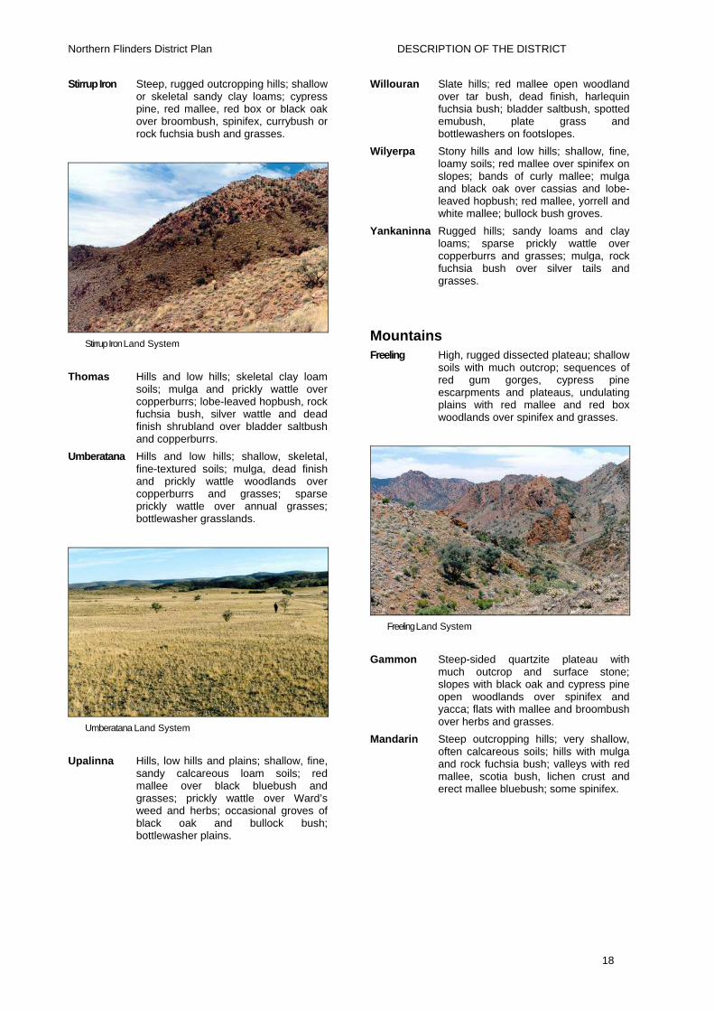
Stirrup Iron Steep, rugged outcropping hills; shallow or skeletal sandy clay loams; cypress pine, red mallee, red box or black oak over broombush, spinifex, currybush or rock fuchsia bush and grasses.
Stirrup Iron Land System
Thomas Hills and low hills; skeletal clay loam soils; mulga and prickly wattle over copperburrs; lobe-leaved hopbush, rock fuchsia bush, silver wattle and dead finish shrubland over bladder saltbush and copperburrs.
Umberatana Hills and low hills; shallow, skeletal, fine-textured soils; mulga, dead finish and prickly wattle woodlands over copperburrs and grasses; sparse prickly wattle over annual grasses; bottlewasher grasslands.
Umberatana Land System
Upalinna Hills, low hills and plains; shallow, fine, sandy calcareous loam soils; red mallee over black bluebush and grasses; prickly wattle over Ward’s weed and herbs; occasional groves of black oak and bullock bush; bottlewasher plains.
Willouran Slate hills; red mallee open woodland over tar bush, dead finish, harlequin fuchsia bush; bladder saltbush, spotted emubush, plate grass and bottlewashers on footslopes.
Wilyerpa Stony hills and low hills; shallow, fine, loamy soils; red mallee over spinifex on slopes; bands of curly mallee; mulga and black oak over cassias and lobe-leaved hopbush; red mallee, yorrell and white mallee; bullock bush groves.
Yankaninna Rugged hills; sandy loams and clay loams; sparse prickly wattle over copperburrs and grasses; mulga, rock fuchsia bush over silver tails and grasses.
Mountains Freeling High, rugged dissected plateau; shallow
soils with much outcrop; sequences of red gum gorges, cypress pine escarpments and plateaus, undulating plains with red mallee and red box woodlands over spinifex and grasses.
Freeling Land System
Gammon Steep-sided quartzite plateau with much outcrop and surface stone; slopes with black oak and cypress pine open woodlands over spinifex and yacca; flats with mallee and broombush over herbs and grasses.
Mandarin Steep outcropping hills; very shallow, often calcareous soils; hills with mulga and rock fuchsia bush; valleys with red mallee, scotia bush, lichen crust and erect mallee bluebush; some spinifex.
18

Northern Flinders District Plan DESCRIPTION OF THE DISTRICT
WATER RESOURCES
Surface water There are some reliable, permanent sources of surface water in the District. There are also a few natural springs, which feed creeks and provide near-permanent soaks and waterholes (limited supply), which are important for domestic and stock use, tourism and the habitat for native fauna. Most natural springs occur on the edge of the ranges, in gullies and creek beds. Most of the natural spring water is potable, however some may be very saline.
Flash flooding, the rapid rise of water in creeks following a rainstorm, is an infrequent but dramatic event.
Aroona Dam on Scott Creek is the water storage and supply for the townships of Leigh Creek, Copley and Lyndhurst, the coalfield and several neighbouring pastoral properties.
Dams are a significant part of the water supply network for domestic and stock use on stations. The location of dams is dependent on soil type, which varies throughout the District and affects the water holding capacity, drainage and water runoff of the catchments. Dam storage is effectively limited by evaporation. About 70% of water stored in dams is lost by evaporation annually. The quality of water is equivalent to rainwater, depending on size of the storage and evaporation rate. Dam water often remains drinkable right until the end, just before it dries out.
There are number of lakes within the district, notably Lake Torrens, which is saline. However, in the small freshwater lakes, water quality remains at a drinkable level until evaporation occurs to the extent that salinity rises above the level, suitable for animal use.
Groundwater Groundwater is the mainstay of the pastoral industry in this District. Nearly all stock water is groundwater. Rainfall, which percolates through the soil, fractured rock surfaces and by the infiltration of surface water in streams (even if they only rarely flow) is stored as groundwater.
Groundwater can be found throughout the
District, although quantity and quality may vary considerably. In the hard rock areas in the ranges, groundwater occurs in joints and fractures. Usually larger supplies can be obtained from fractures in the harder brittle sandstones and quartzites compared to the softer shales. Some limestone layers have cavities, which have formed by percolating slightly acid rainwater dissolving the alkaline limestone. Such cavities can supply high yields, eg. supplementing the town water supply for Leigh Creek.
In the sediment-filled valleys and basins, groundwater is stored between the individual grains of gravel, sand or silt, much like a bath, which is filled with sand but can still be half-filled with water.
Good stock quality water can be found throughout the area from both the fractured (confined and unconfined) rock aquifer and shallow wells in alluvium with salinities often between 20 and 5,000 mg / L (5,000ppm – 15,000ppm). Similarly, very good stock quality water can be obtained from sediments in both the Frome Embayment and the Pirie-Torrens Basin.
The Great Artesian Basin (GAB) extends into the northeast of the District. Water enters this aquifer by rainfall in the Great Dividing Range in Queensland and moves in a southwesterly direction into South Australia at a very slow rate of about one metre per year, which means it takes about 2 million years to travel to Lake Eyre. The aquifer is confined by the overlying fine-grained Bulldog Shale, which keeps the groundwater under pressure.
Groundwater discharges from the GAB by mound spring eg. Hotel Springs (Moolawatana Station), flowing bores and by diffuse upward leakage through the Bulldog Shale at slow rates. Because of the great depth of the aquifer in some areas, the temperature of the water can often reach boiling point (100oC). Mound springs form along fault lines or fractures which allow the groundwater to discharge more easily up through the confining Bulldog Shale. The salinity of the GAB groundwater is generally less than 2,000 mg / L.
19

Northern Flinders District Plan DESCRIPTION OF THE DISTRICT
LAND USE HISTORY The history section is based chiefly on Mincham 1964 and 1980.
Aboriginal Cultural Regions Five Aboriginal cultural regions and groups occupied different parts of the Northern Flinders Ranges Soil Conservation District. The Jadliaura cultural region includes the eastern plain from Mt. McKinlay almost to the site of Quorn and included Cradock. The Pangkala cultural region lies mostly on the western plain and included country on each side of the southern part of Lake Torrens and much of Eyre Peninsula. North of the Pangkala the Kujani cultural region extended to Lake Eyre South and includes Parachilna and Beltana. The area to the northwest of Lake Frome is the Pilatapa cultural region. The spine of the northern Flinders Ranges is the cultural region of the Wailpi or Adnjamathanha (Hemming and Clark 1989).
Exploration Early exploration of the area began with Edward John Eyre in 1839. Eyre travelled up from Spencer Gulf to Depot Creek south of Mt. Arden, where there was permanent spring water, and then followed the Flinders Ranges northwards. From a high point (Mt. Eyre) he sighted Lake Torrens.
In 1840 Eyre’s third exploration set out from Government House and travelled north via Gawler, Crystal Brook and Mt. Remarkable, which he named. A base camp was established at Depot Creek from which he headed further north to Mt. Eyre, which he again climbed to see Lake Torrens. Eyre then rode to the lake over plains and sand hills to a ‘desolate and forbidding shore’. He then made his way to, climbed and named Mt. Deception, from which he saw Lake Torrens ‘large and mysterious as ever’ and to the north he could see only ‘a cheerless-looking waste’. His only consolation was that there were so many traces of Aboriginal occupation of the area that he felt sure the ranges were certain to contain adequate supplies of water.
From Mt. Deception, Eyre rode southeast and found and named Depot Pool southeast
of Beltana. He moved his base camp to Depot Pool and then explored further north to a hill he named ‘Termination Hill’. On returning he found ‘a large hole of rain water among the rocks’ on a creek he named Scott Creek to which the base camp was moved. Eyre then pressed northward to a hill he named ‘Mt. Nor-west’. Maintaining a course to the northwest, Eyre found himself in wide, open, stony country in which there were ‘scattered fragments of tableland’ and then reached the winding arm of what he thought was Lake Torrens but which was actually Lake Eyre South. He returned to the Scott Creek camp and explored the creek, describing the scenery as ‘grand and sublime’. Aroona Dam is built on Scott Creek.
Eyre and his party left the Scott Creek camp and headed northeast passing over Leigh Creek (which he did not name) and Mundy and Burr creeks (which he named). He camped in the bed of Burr Creek at a spot he called Depot Springs. To the south and east of this camp is Mt. Serle, which Eyre named, and on route to climb this mount he crossed and named the Frome River. From the top of Mt. Serle he saw his ‘worst forebodings’, “Lake Torrens” now faced him to the east. He was convinced that the lake he saw to the east was part of a horseshoe-shape, which stretched up the western side of the ranges around their northern end and down their eastern flank.
Eyre set off to the northeast, not to satisfy him, for the view from the top of Mt. Serle had already done that, but to discharge his duty to the Governor and the promoters of the expedition. Eyre rode to and named Mt. Distance, from which he could not see the expected barrier, and so rode on for another day to Mt. Hopeless, which he named even before he reached it. And from the top he saw, as he had known he must, salt lakes to the north and to the east. For him the matter was settled ‘beyond all doubt’. In fact the northern stretch of lake he saw was Lake Blanche and the eastern stretch, Lake Callabonna.
Pastoralism Less than 20 years after the explorations of Eyre, a great patchwork of sheep and cattle runs spread throughout these ranges.
Pastoral settlement in the 1850s
20

Northern Flinders District Plan DESCRIPTION OF THE DISTRICT
immediately disrupted the traditional life of the Aborigines. The settlers took possession of the precious permanent waters, around which sheep were shepherded and grazed to a radius of about seven kilometres. The settlers soon extended their occupation further by sinking wells, which permitted sheep to be grazed over greater areas. In some areas, flocks of up to 10,000 sheep were not uncommon.
During the great drought of the mid-1860s Aborigines throughout the Flinders beyond Mt. Brown suffered intensely, for the drought devastated a country, which had been overstocked and eaten bare. J.B. Hughes who, after travelling north as far as Yudnamutana in June 1865, wrote to The Register stating that "the Christian inhabitants of South Australia are lamentably neglecting their duty to the Aborigine....". He stressed that they were almost starving because most of their game had died in the drought. "Wallabies, euros and kangaroos were lying dead in all directions.".
Traditional tribal life, though modified by pastoral settlement and mining operations, continued longer in the northern Flinders Ranges than in the Hawker locality. Most Aboriginal descendants today, including those who live at Hawker, are of Wailpi or Adnjamathanha origin. The last full blood died in 1973.
As the number of stock in the colony grew so did the demand for new pastoral land. Two doctors by the name of Browne played a notable part in establishing pastoralism in the North Flinders. In 1850 the Brownes applied for the leases of Arkaba, Wilpena, and Aroona, which they opened as stations in early 1851. These were among the first batch of 14-year leases issued.
Until 1851 all runs beyond the surveyed areas had been held on occupation licence, which had to be renewed annually. On 7 November 1850 Governor Young’s Order In Council authorised in the “Government Gazette” the granting of pastoral leases for a term of 14 years. The promise of extended tenure speeded the search for country suitable for runs, resulting in a rapid pastoral expansion throughout 1851-52. These leases required that within three months the claim be stocked with sixteen
cattle or 100 sheep per square mile. A squatter was also required to furnish a plan of the run claimed, accurately drawn at a scale of not less than one half inch to the mile, showing the position of the run in relation to some point laid down on the map in the Surveyor General’s Office. At the same time the squatter had to pay a deposit of £5.
Assistant Surveyor General W.G. Goyder made his first trip to the region in April 1857. His task was to survey a road through Pichi Richi Pass and to start a private surveyor J.M. Painter on a survey beginning at Mt. Serle. During this expedition Goyder, deceived by observations of artesian springs and heavy rain in the far northeast of the District saw Lake Torrens as ‘a depot for future observations of the northern districts’ and suggested ‘a properly constructed boat (be) placed upon its waters’. He also recommended the sinking of a series of wells along the western plain of the Ranges.
Goyder’s account of the inland lake created excitement and destroyed the reputation of Eyre as an explorer. Eyre’s horseshoe barrier was broken at last by fresh water! Applications for leases poured in.
By this time the regulations for the issue of a lease had been modified. Lessees were now permitted a year to stock their claims and the number of stock per square mile had been reduced to 50 sheep or eight cattle per square mile.
In 1858 A.C. Gregory cracked the horseshoe. He left Moreton Bay in Queensland to follow the tracks of Leichhardt who had disappeared 10 years previously. Gregory followed Cooper Creek to its junction with the Strzelecki, the bed of which led him down to Lake Blanche. Here he had no difficulty passing between the lakes now known as Blanche and Callabonna to Mt. Hopeless and from there continued by way of the ranges to Adelaide.
The northern boom continued until late 1864 but prolonged drought, overgrazing of heavily stocked runs, and shortages of water at supposedly permanent waters, and caused the death of large numbers of stock. Some pastoralists moved their stock south for agistment but many left it too late to move weakened and starving sheep and
21

Northern Flinders District Plan DESCRIPTION OF THE DISTRICT
cattle. The drought referred to as the great drought continued in some areas until 1866. It depopulated the northern Flinders and ended mining at Yudnamutana, Nuccaleena, Oratunga and other places. Blinman managed to survive.
Many of the pastoralists hard hit by the drought of 1863-6 appealed to the Government for the remission of rent for two years and for other concessions. They strongly condemned Goyder for his excessive valuations. Originally the rent on runs was 10 shillings per square mile, but after a few years it was felt that the pastoralists were paying too little for the runs, which enabled them to drive around in buggies and coaches and live in fine houses. So a levy of two pence per sheep was introduced to be paid according to the carrying capacity of each run as assessed by the Surveyor-General. This he had carried out during exceptionally favourable seasons. Many of Goyder’s assessments were unreasonably high; for example Arkaba 105, and Wilpena 77 sheep per square mile. Many blamed Goyder for the over-stocked runs and therefore the great suffering during the drought.
The appeals made it necessary for the southern limit of the drought to be defined on a map; this line is now known as Goyder’s Line. The pastoralists beyond the line won concessions, which, it seems, stemmed the exodus from the northern country and the consequent loss of rents. After the Great Drought better seasons returned. Flocks were moved north again, wool prices rose to a peak in 1871, fencing became general and shepherding declined. The pastoralists on the runs beyond Goyder’s Line seemed assured of a prosperous future.
Farming The harvest of 1870-1 was a record and the Government was pressed upon to open up new areas to farming. The optimism generated by the very good harvest after the rains of 1875 led to the planning in 1876 of a big expansion to the east and north of Kanyaka. Ten new hundreds were surveyed for proclamation early in 1877 including the hundreds of Yednalue, Wonoka and Arkaba and the isolated hundred of Carr near
Blinman. The hundred of Carr was surveyed and sold not for farming so much as to provide land for the numerous teamsters to hold their animals and to grow feed. The teamsters had until then complained that they were trespassers as soon as they unyoked their bullocks.
With the revenue of the land sales flowing in, the Government began to seriously consider extending the railway north from Port Augusta, which had been sought by the copper mining interests since 1860.
During the winter of 1882 there were heated exchanges in the Parliamentary debates on the question of the agricultural advance onto the northern areas, with the Hon. J. Carr contending that ‘despite all that had been said against it, there was a good deal of truth in the maxim that “rain follows the plough”.’ Mr Rudolf Henning (who had arrived with his parents from Germany in 1849) strongly advocated ‘the stoppage of selection beyond Goyder’s Line...’ He contended that ‘a huge blunder had been committed in allowing the selectors to go up north on land not worth the money they undertook to pay for it’. He said the bulk of the country in South Australia was ‘poor and miserable from having such scanty rainfall.’
In 1886 the farmer who had settled in the hundred of Coomooroo reported ‘rabbits which have preceded the farmers, are very numerous here and threaten to become a serious pest’; the Holowiliena diaries first recorded rabbits on that station in August 1878 and afterwards made frequent reference to the efforts to eliminate them. The main source of the northern invasion of the rabbit was apparently Anlaby Station where they were released on Julia Creek. They remained there without spreading very much due to predation by native cats (Dasyurids), but when the cats disappeared in about 1866 the rabbits spread rapidly.
In 1881 the Government had surveyed a string of hundreds up the western plain ahead of the railway in anticipation of the continuing advance of the wheat farmers. The drought of the 1880s ended the advance and the hundreds were divided into blocks for grazing.
In 1900 the Hill family took up the lease of the Wilpena Pound for 21 years. John Hill on his farm Glenallen, in the Hundred of
22

Northern Flinders District Plan DESCRIPTION OF THE DISTRICT
Arkaba, had failed to grow wheat profitably in most seasons over the preceding 20 years. He was impressed by the higher and more reliable rainfall in the Pound and with his five sons was not daunted by the difficulties of building an access road into the Pound and clearing the floor of the pound for cropping. The venture proved successful in producing wheat. Old-timers have often said that the best wheat ever brought into Hawker was grown by the Hills in the Pound. In 1902, a year of extreme drought, the Hills were the only farmers in the District with a crop to reap. In 1904 the drought ended in a terrific downpour, which washed away the road into the Pound. The Hills abandoned the Pound for wheat, and one son continued with the lease until 1910 when the Government paid him £140 for the house and £173/16/- for other improvements.
Mining John Bull, made the first discovery of copper in the Northern Flinders in 1856, along the Warrioota Creek near Beltana Station (Klaassen 1986).
Other discoveries soon followed, and at the end of the 1850s many mines had been discovered in the Northern Flinders Ranges, most being copper. The best known of them were the Blinman, discovered by Robert Blinman, and the Yudnamutana, discovered by Frost and Gleeson. There were many others, less well known, such as Mochatoona, Mount Rose, the Welcome Mine, Parabarana, Oratunga and the Appealina. Copper was discovered in Sliding Rock Creek in 1869.
Mining companies were formed to mine these deposits. One of the best known was the Great Northern Mining Company, floated in 1859. This company worked many mines in the Northern Flinders, such as Mount Chambers, Mount Deception, Mount McKinlay, Mount Samuel, Two Brothers and the Nuccaleena.
As transport was costly, miners and mining companies pressured the Government for a railway from Port Augusta to Nuccaleena. During 1860 the Government had surveyed a line north from Port Augusta. With one of the worst droughts ever to hit South Australia, in the 1860s the Government did
put in a few wells to help the teamsters along the main tracks.
Mr R A Fiveash, the Superintendent of the Yudnamutana Mining Company was convinced that if a railway was constructed from Port Augusta, he could send down 1,000 tons a month from the Blinman and 2,000 tons from the Yudnamutana mines, with the greatest ease. Unfortunately, by the time the Port Augusta line was finally built in the 1880s most of the mines in the north had been closed and forgotten (Klaassen 1986).
Transport of copper in the 1870s was an arduous task. Bags of washed copper were transported by bullock-team to Port Augusta, from where it was carried by steamer to Port Adelaide. In 1892 gold was discovered at Sliding Rock by a Mr Davies and about 40 miners rushed to the field. This gold was the result of Davies’ son salting the claims. Sliding Rock was finally closed in the early 1900s after large bodies of water continually flooded the mine. This same water is now used to augment the Aroona Dam supply for Leigh Creek.
In 1888 John Henry Reid discovered coal-bearing shale during the sinking of a railway dam in the Leigh Creek area. This discovery led to the establishment of underground workings. Number 1 shaft sunk by the Leigh Creek Coal Mining Co was abandoned on striking a heavy flow of water. It was not until 1940 that the Leigh Creek deposits were reconsidered. Exploratory boring by the Mines Department began in 1941. Control of the open-cut and excavation commenced in 1943. It was obvious that the electricity supply industry would use most of the coal for power generation and the coalfield was transferred to the Electricity Trust of South Australia in 1948. The use of large excavating machines, together with the rebuilding of a railway line between Leigh Creek and Port Augusta by the Commonwealth Railways, resulted in economic production and delivery of coal to the Thomas Playford Power Station. The decision to build a 500 megawatt Northern Power Station alongside the Thomas Playford Power Station at Port Augusta in the mid 1970s saw the enlargement of the coalfield using new methods to extract deeper coal and increase production Because the existing
23

Northern Flinders District Plan DESCRIPTION OF THE DISTRICT
town was located within the coal basin, a new town, Leigh Creek South, was built south of the coalfield.
New uranium mining initiatives are located at Beverley on Wooltana Pastoral Lease.
Transport The Flinders was on the droving route from Queensland to the Adelaide market. Drovers brought stock down to Hawker from places like Winton; they then were trucked to Adelaide. When the railway reached Marree, stock were then loaded there.
Sheep were also walked to the large stock markets at Carrieton and Quorn.
Stock were also trucked north to Hawker and then walked to their destinations. The last droving in the District was in the 1950s.
In 1867 Sir Thomas Elder established a camel breeding station with 123 animals. These camels were driven to his Beltana property by 12 Afghans (this was just 14 years before the coming of the railway). Soon some of the camels were being used in the general carrying business up and down the western plains and along the route of the future railway, transporting equipment to the copper mines in the Flinders Ranges and carrying mined ore to Port Augusta for export (Fuller 1975).
While camels were superior transport in the open, treeless plains and sandhill country, and bullocks excelled at pulling great loads in heavy wet areas, the donkey was hardy, surefooted, easy to train and outfit, and ideally suited for working in tough outback conditions. In the years before 1908 when the Blinman Smelters were still operating, donkey teams brought in ore from smaller outlying mines.
As late as 1909 donkeys were still being imported from Spain. Early Beltana Pastoral Co stations used mules, donkeys or camels. Horses were worked only on Cordillo Downs.
By the late 1940s working donkeys were a rarity and had been almost totally replaced by motorised transport.
In 1857 impatient miners in the Flinders Ranges were pressing for a railway to serve their needs, but at that time construction had advanced only about 25 miles north of
Adelaide. There was talk of a horse drawn train, but this was dropped because of insufficient feed near the routes intended. The miners also complained of the poor standard of roads. Eighteen years later, when the railway building started, the roads were no better. One account stated that on the western plain “the ground is so torn up in places, so boggy in others that one unfortunate who had loaded with wool could only progress toward Port Augusta at the rate of 5 miles per day, and in the first six miles capsized and had to unload twice”.
Government attitude appears to have been that no matter how rich a copper mine it must eventually reach a production limit, and then the District it had made prosperous would decline. Thus mines ensured no continuity of traffic, and so afforded insufficient justification for expensive railway construction.
However the Great Northern Mining Company directors engaged a civil engineer in 1860s to survey a route for a northern railway, up the western plain from Port Augusta to Parachilna Creek where it would swing eastward to Mt. Samuel and Oratunga. At this time bullockies were becoming more avaricious, charging between £9 and £11 a ton for the Blinman–Port Augusta round trip. No copper mine could afford this and the need for a railway was admitted. Knowing the strength of their position the bullockies withheld their labour as it suited them – camel transport was still five years in the future. This was when the steam traction engines were bought by the Yudnamutana Copper Mining Company and tested. During a trial in September 1863, where the ground was hard, the engine travelled at a good rate, but in sandy tracts it came to a halt. However, the engines were put to use, but not at the expected 5 mph as the road was in no condition to accept so high a speed. These early road trains worked between Blinman and Port Augusta, but lack of wood for the boilers eventually proved their downfall (Klaassen 1986).
Work on the railway eventually started and it reached Hawker in 1880, Marree in 1884 and in Oodnadatta 1890. Camels were used to cart sleepers, rails and supplies to the construction teams. Camel transport ended in the late 1930s (Fuller 1975).
24

Northern Flinders District Plan DESCRIPTION OF THE DISTRICT
In the late 1850s William Rounsevell was driving a weekly mail cart between Port Augusta and Copley, using a nine-horse team to “ensure passage on sandy stretches”. Conway’s mail from Mern Merna had to be driven over the plain at walking speed (Fuller 1975).
The road to Wilpena Pound was sealed in the 1970s and the Hawker to Lyndhurst road was also sealed in the late 1970s and early 1980s.
However, the road conditions in the district have generally deteriorated over the intervening years. Especially the main arterial roads during recent years, even though a lot of maintenance work is being done. This may be due to the use of low quality materials, related to cuts in government funding.
Communication Overland telegraph using Morse Code was the first form of telecommunication. This continued into at least the 1930s.
The first telephone in Hawker was at the railway station for rail traffic control. There were about a dozen telephones manned by staff at the Post Office before 1927, when the first telephonist, Nell Rowe (nee Ganley), was employed. This was when party line telephones were introduced to properties in the area. The Government paid for the installation of these lines to the property boundaries, then the landowners had to erect the lines to their homes. When Nell was employed in 1927, telephonists had to be dismissed at 19 years of age, so their careers were very short. All telegrams from the north went to Hawker by telegraph before being sent on to their destinations.
Mail services in the 1800s ran by coach from Burra to Arkaba and points north on the eastern side of the Flinders Ranges.
PRESENT LAND USE Pastoral
There are approximately 80 pastoral runs in the District on which wool, mutton and beef cattle are produced by grazing stock on native and volunteer pastures. Pastoralism is the most extensive land use in the District, and continues to support a
significant population.
The carrying capacity of vegetation and soils varies depending on land type and station infrastructure and historical and present land management practices. The average carrying capacity of the District is low in most pasture types. In general, stocking rates range up to 15 DSE sheep / km2 depending on the water supply, season and vegetation condition. Further details are given in the Pastoral Land Management section.
Tourism Tourism is a growing industry in the Northern Flinders Ranges, one of the most scenic areas of South Australia. Tourism offers visitors a wide range of activities and experiences, which have appeal to the young through to the elderly who enjoy the outdoor life. The area is noted for its scenic beauty, outdoor experiences, unique flora and fauna, fascinating geology and Aboriginal and European heritage.
The tourist industry is significant in the District and provides employment, infrastructure and tourist facilities located at Wilpena in the Flinders Ranges National Park (FRNP), at Angorichina, Arkaroola, Beltana, Blinman, Cradock, Vulkathunha-Gammon Ranges National Park (GRNP), Hawker, Leigh Creek, Lyndhurst and Parachilna. Many stations in the region also offer accommodation and activities such as self-drive 4WD tours for tourists.
The Flinders Ranges offer the bushwalker a variety of walking trails including the Heysen Trail and others of varying duration. The Mawson Trail offers the opportunity to tour the region by bicycle. Tours of the region are offered by many tour operators and provide a range of activities including coach tours, personalised 4WD tours, camel trekking, horse riding, bushwalking, town tours, and scenic flights.
Approximately 150,000 people visit and stay within the FRNP each year (2001) and it is estimated that a further 20,000 people make day visits to the park each year; 43% of the visitors are driving a 4WD and 40% are driving a standard car; 55% come from interstate, and 15% are international visitors (FRNP Visitor Survey 200/2001 DEH). Average length of stay is 2.75 days.
25

Northern Flinders District Plan DESCRIPTION OF THE DISTRICT
Visitation to the FRNP exhibits a strong seasonal bias with spring and autumn stretching park facilities to the limit. Most visitors stay at Wilpena but bush camping elsewhere in the park is becoming more popular as basic facilities are extended to these areas. 90% of all park visitors go to Wilpena at some stage. Visitors are mainly from South Australia and Victoria. Overseas visitors make up about 10% of the visitor population.
The FRNP is the core destination for visitors to the region and therefore contributes significantly for the regional economy. Accommodation, nature based tourism and bus tours rely heavily on the park’s natural and cultural resources.
The pattern of visitor use of the GRNP has changed over the past decade or so. Prior to dedication and in the years following 1970 the GRNP was used primarily by wilderness bush walkers and occasionally by vehicle-based campers. Following dedication of the Balcanoona Lease in 1982 the park became accessible to a wider range of visitors, who caused impacts of concern. Approximately 15,000 people visited GRNP in 2001 (Visitor Data System GRNP DEH); 83% overnight park stay and 17% day visit; average length of stay 2 nights; 80% 4WD and 19% car; 53% interstate, 41% intrastate and 7% international. (GRNP Visitor Survey 2001/2002 DEH). Both camping and accommodation is offered in park. Visitor impacts need to be managed in popular camping areas such as Weetootla Gorge, Grindell’s Hut and Italowie Gorge.
Arkaroola Tourist Village has facilities including an airstrip, motel style accommodation and camping grounds.
Conservation The vegetation and habitats of the District are primarily native. Some plant species are rare or endangered. Species and habitat management and conservation is the responsibility of all land managers, not just the Government.
The control of feral animals, particularly rabbits, goats and foxes, is very important in conservation of the natural heritage. Efforts to control these feral animals are being
made by concerned land managers.
The three National Parks Reserves in the District, - Flinders Ranges National Park, Vulkathunha-Gammon Ranges National Park and Lake Torrens National Park, provide public access to the unique landscape, flora and fauna of the region. There are four private sanctuaries presently operating under NPW legislation, - Arkaroola, managed by the Sprigg family, and Aroona Dam, managed by NRG Flinders and the Bunkers Conservation Reserve managed by the Hunting and Conservation Branch of the Sporting Shooters Association of Australia. The Wetlands and Wildlife Company also manage Waraweena pastoral lease for conservation purposes. The Ediacara Fossil Reserve protects fossils of the Ediacara assemblage.
Flinders Ranges National Park (FRNP)
The core values of the FRNP are:
• A large tract of land reserved for nature conservation purposes and capable (with appropriate management) of maintaining ecosystems that preserve populations of significant wildlife, including vulnerable, rare and endangered species.
• Land containing outstanding scenic quality generally not visually intruded by the activities or constraints of people.
• Land containing a world-class geological and morphological record, and an extensive fossil record of some of the earliest life on earth.
• Land offering visitors a comprehensive and particularly broad range of recreation opportunities and educational experiences.
• A State and regional tourism asset of economic significance and which represents an important economic opportunity.
Within the FRNP there are currently 85 plant species of conservation significance at national, State and regional level. Of the 85 species almost 71% occur within Wilpena Pound, 20% occur in the Oraparinna section of the park and 1% have been recorded in the “Wilpena Station” lands. Many of the plants are confined to rocky moist habitats
26
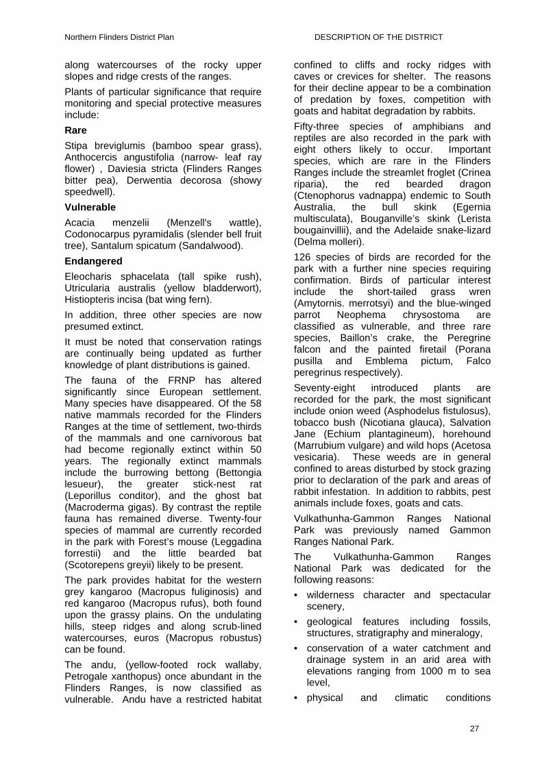
Northern Flinders District Plan DESCRIPTION OF THE DISTRICT
along watercourses of the rocky upper slopes and ridge crests of the ranges.
Plants of particular significance that require monitoring and special protective measures include:
Rare
Stipa breviglumis (bamboo spear grass), Anthocercis angustifolia (narrow- leaf ray flower) , Daviesia stricta (Flinders Ranges bitter pea), Derwentia decorosa (showy speedwell).
Vulnerable
Acacia menzelii (Menzell's wattle), Codonocarpus pyramidalis (slender bell fruit tree), Santalum spicatum (Sandalwood).
Endangered
Eleocharis sphacelata (tall spike rush), Utricularia australis (yellow bladderwort), Histiopteris incisa (bat wing fern).
In addition, three other species are now presumed extinct.
It must be noted that conservation ratings are continually being updated as further knowledge of plant distributions is gained.
The fauna of the FRNP has altered significantly since European settlement. Many species have disappeared. Of the 58 native mammals recorded for the Flinders Ranges at the time of settlement, two-thirds of the mammals and one carnivorous bat had become regionally extinct within 50 years. The regionally extinct mammals include the burrowing bettong (Bettongia lesueur), the greater stick-nest rat (Leporillus conditor), and the ghost bat (Macroderma gigas). By contrast the reptile fauna has remained diverse. Twenty-four species of mammal are currently recorded in the park with Forest’s mouse (Leggadina forrestii) and the little bearded bat (Scotorepens greyii) likely to be present.
The park provides habitat for the western grey kangaroo (Macropus fuliginosis) and red kangaroo (Macropus rufus), both found upon the grassy plains. On the undulating hills, steep ridges and along scrub-lined watercourses, euros (Macropus robustus) can be found.
The andu, (yellow-footed rock wallaby, Petrogale xanthopus) once abundant in the Flinders Ranges, is now classified as vulnerable. Andu have a restricted habitat
confined to cliffs and rocky ridges with caves or crevices for shelter. The reasons for their decline appear to be a combination of predation by foxes, competition with goats and habitat degradation by rabbits.
Fifty-three species of amphibians and reptiles are also recorded in the park with eight others likely to occur. Important species, which are rare in the Flinders Ranges include the streamlet froglet (Crinea riparia), the red bearded dragon (Ctenophorus vadnappa) endemic to South Australia, the bull skink (Egernia multisculata), Bouganville’s skink (Lerista bougainvillii), and the Adelaide snake-lizard (Delma molleri).
126 species of birds are recorded for the park with a further nine species requiring confirmation. Birds of particular interest include the short-tailed grass wren (Amytornis. merrotsyi) and the blue-winged parrot Neophema chrysostoma are classified as vulnerable, and three rare species, Baillon’s crake, the Peregrine falcon and the painted firetail (Porana pusilla and Emblema pictum, Falco peregrinus respectively).
Seventy-eight introduced plants are recorded for the park, the most significant include onion weed (Asphodelus fistulosus), tobacco bush (Nicotiana glauca), Salvation Jane (Echium plantagineum), horehound (Marrubium vulgare) and wild hops (Acetosa vesicaria). These weeds are in general confined to areas disturbed by stock grazing prior to declaration of the park and areas of rabbit infestation. In addition to rabbits, pest animals include foxes, goats and cats.
Vulkathunha-Gammon Ranges National Park was previously named Gammon Ranges National Park.
The Vulkathunha-Gammon Ranges National Park was dedicated for the following reasons:
• wilderness character and spectacular scenery,
• geological features including fossils, structures, stratigraphy and mineralogy,
• conservation of a water catchment and drainage system in an arid area with elevations ranging from 1000 m to sea level,
• physical and climatic conditions
27

Northern Flinders District Plan DESCRIPTION OF THE DISTRICT
supporting relict species and communities,
• botanic features including regional endemic species like Eucalyptus gillii, relict species like Melaleuca uncinata and rare species such as Acacia araneosa,
• to conserve populations of andu (yellow-footed rock wallaby) and their habitat,
• to conserve significant examples of ancient Aboriginal rock art, sites of Aboriginal significance and Aboriginal occupation sites,
• to conserve important examples of the history of European occupation and settlement, and
• to meet community demand for such a wilderness park relatively close to major highways.
The Gammon Ranges contain a number of species of conservation, botanical or biogeographical significance, these include: Acacia araneosa, Acacia beckleri, Eremophila alternifolia, Prostranthera striatiflora, Melaleuca uncinata, Eucalyptus flindersii, Eucalyptus viridis, Acacia rivalis, Condoncarpus pyramidalis, Acacia confluens, Doodia caudata and Pteris tremula.
The distribution of fauna species in the Flinders Ranges is of biogeographical importance. The comparatively moist habitats of the Ranges allow some temperate species to persist.
Twenty-seven species of mammal are recorded in the park, while another 12 occur within the region, and can be expected to occur within the park. Up to 22 species have become locally extinct since European settlement.
Important species within the park today include the andu (yellow-footed rock wallaby Petrogale xanthopus), the narrow nosed planigale (Planigale tenuirostris), the fat tailed dunnart (Sminthopsis crassicaudata), and the stripe-faced dunnart (Sminthopsis macroura). The native rodent Forrest’s mouse (Leggadina forresti) is recorded for the plains block. Three species of Pseudomys (native rodent) may occur within the park.
Over 70 bird species have been recorded in the park and an additional 53 species may
occur but confirmation is required. Many bat species are recorded for the park including the now locally extinct ghost bat. The dingo is mostly excluded from the park by the dog fence.
Pest animals include rabbits, cats, foxes, goats and donkeys.
Due to the remote location and difficult terrain, the fauna and their habitat requirements are not well studied in the park. Changes to habitats and native fauna brought about by past land uses and as a result of feral animals are only partly understood. The conservation of the fauna of the park will benefit from surveys and management-oriented studies.
Further information on these National Parks can be found in their respective Park Management Plans.
Mining Mining is a vital component of the economy of the Northern Flinders Ranges. Much of the existing infrastructure, including schools and health facilities in the area would not be viable without the mining industry.
However, mining is a temporary land use. There are numerous abandoned mines throughout the District from which minerals such as copper, radium and uranium were extracted. Current mining operations in the District include the extraction of coal, talc, slate, barytes, uranium and zinc.
Agriculture In the south of the District cereal growing is undertaken to a very minor extent. The most critical limitation for dryland agriculture is the lack of reliable rainfall. Given sufficient rainfalls during the growing season reasonable cereal yields can be achieved.
Cropping land not cropped for five successive years constitutes a change in land use under the Native Vegetation Act 1991, and the Regulations require an application to be made to the Native Vegetation Management Branch (DEH) for permission to cultivate.
28

Northern Flinders District Plan DESCRIPTION OF THE DISTRICT
Urban Areas and Infrastructure The towns and settlements of Hawker, Leigh Creek, Beltana, Parachilna, Copley, Nepabunna and Blinman occupy a small area of the District but house the majority of the population. Infrastructure including communications, transport, housing, roads, railways, airports, pipelines, dams and recreational facilities are necessary to their needs.
The main road through the District from north to south is sealed, as is the road from Hawker to Wilpena Pound. All other roads in the District are unsealed. The railway between Leigh Creek and Port Augusta is used to transport coal from the Leigh Creek coal mines to the power station at Port Augusta.
There are two hospitals in the District, at Leigh Creek and Hawker. The Royal Flying Doctor Service provides medical services throughout the District including regular clinics at Blinman, Wertaloona, Wirrealpa and Nepabunna, and emergency evacuation of patients.
The two schools in the area are the Hawker Area School and the Leigh Creek Area School. The School of Distance Education provides education services to students on stations and smaller settlements, which now runs on satellite communication, which has replaced the HF radio system.
Communication / Transport Telephone service is available throughout the District. Overhead telephone lines have been replaced by the Digital Radio Concentrator System (DRCS) and fibre optic cables making it possible for people in the region to use facsimile and computer networks. Code Division Multiple Access (CDMA) mobile phones are in use in some of the larger settlements.
UHF radio repeater towers are located such that virtually all the District is covered. The channels used in the District are 3, 4, 6, and 7.
Many people in the District still use HF radio. However, the introduction of the Telestra broadband Internet system has allowed incredibly fast Internet access to stations and more remote settlements. The increasing use of Internet as a communication system and access to
information and facilities has meant that HF radio is of less use as a primary communication method. The Government Radio network (GRN) is being implemented in the district for use by emergency services such as CFS.
There are sealed airstrips at Hawker, Balcanoona and Leigh Creek and numerous private airstrips throughout the District.
The Moomba to Point Bonython liquids and Moomba to Adelaide gas pipelines pass through the District.
LAND TENURE There are several systems of land tenure in the Northern Flinders Ranges Soil Conservation District, each affected and managed by different State legislation. The major classes of tenure are freehold and leasehold.
The forms of tenure occurring within the District include:
• Pastoral Lease
• Perpetual Lease
• Freehold Land
• Miscellaneous Lease
• Reserve
• Unallotted Crown Land
• Mining and Mineral Extraction Lease
Pastoral Lease Pastoral Leasehold land is Crown Land leased under the Pastoral Land Management and Conservation Act 1989 for a 42-year renewable term, with rent payable on annual basis. The lease may include land management conditions providing for the following matters:
• the species of animals depastured on the land;
• maximum stocking levels for the lease;
• the purposes to which the land is put;
• maintenance of existing fencing and constructed stock watering points; and
• rehabilitation of degraded land.
The Pastoral Board may vary the land management conditions on a lease if the
29

Northern Flinders District Plan DESCRIPTION OF THE DISTRICT
lease has been assessed as required by the Act, and notice is given to the lessee in writing at least four months before the variation takes effect.
Pastoral lessees must obtain permission from the Pastoral Board to increase stock numbers beyond the maximum set for the lease, take stock on agistment or change land use. Pastoral leases are subject to inspection by Pastoral Inspectors and land condition assessment officers.
Some lands (particularly pastoral lease and NPWS lands) within the district are subject to Native Title claims.
Perpetual Lease Perpetual leases are leases issued by the Crown entitling the lessee, the lessee’s heirs and assigns, to use a particular area of land for a specific purpose, usually agriculture, forever.
The 25 or so different types of Perpetual Lease all have different covenants and conditions. In many cases the covenants and conditions are outdated (eg. erect no brush fences), or have been superseded by other legislation (eg. control weeds and rabbits). The rental on Perpetual Leases is generally fixed and not subject to review; most rentals are less than $25 per annum.
The payment of an annual rental and the need to obtain approvals to effect transactions on a Perpetual Lease is now the only real difference between perpetual leasehold and freehold titles.
Marginal Lands Perpetual Leases are issued under the Marginal Lands Act 1940. Covenants on these leases require the following specific conservation practices:
• the reservation of 5 acres in every 250 acres for the growth of timber which shall not be destroyed;
• set apart and keep reserved for the purpose of preventing soil erosion areas covered with natural scrub growth, not to exceed one tenth of the area of the lease; and
• destroy and keep the lease free of vermin.
The current government is reviewing its policy on the administration of Perpetual
Leases, which includes two distinct zones. Within the North Flinders District, some perpetual Leases are considered to be in the ”Transitional Zone”, and the opportunity to freehold is still valid. The other zone is termed “Rangelands” and these will dealt with on a case by case basis.
However, in the interim the following provisions are still valid:
• treat perpetual leasehold land as freehold, recognising the financial interest of Government and within the constraint that perpetual leaseholders are tenants; and
• perpetual leases of all types will be subject to the provisions of the Soil Conservation and Land Care Act 1989 as if they were held in freehold title.
Freehold Land This land is held in fee simple, and the interest in the land can be inherited. Freehold land, including properties within the townships of Hawker and Blinman are still subject to the provisions of the Soil Conservation and Land Care Act 1989.
Indigenous Protected Areas The Nantawarrina Aboriginal Land is held in fee simple by the Aboriginal Lands Trust and leased under the Aboriginal Lands Trust Act 1966 to the Nantawarrina Community for a term of 99 years with right to renewal, commencing July 20th 1988. This Land has now been declared as an Indigenous Protected Area.
As freehold land, it is still subject to the provisions of the Soil Conservation and Land Care Act 1989.
Miscellaneous Lease Miscellaneous leases are issued for less than 21 years for a variety of purposes and at whatever terms and conditions the Minister thinks fit.
Reserves There are several types of reserves created under various Acts generally for specific public purposes. They can be placed under
30

Northern Flinders District Plan DESCRIPTION OF THE DISTRICT
Mining, Exploration and Mineral the care, control and management of Government or incorporated under community bodies or, they can become the responsibility of a particular body by virtue of the Act under which they were created (eg. national parks).
Extraction Lease These leases are an agreement between the lessee and the Government, which gives the lessee the right to mine minerals in accordance with the Mining Act 1971 and the Mines and Works Inspection Act 1926.
Some of the purposes of reserves include:
• recreation, water and conservation reserves,
The general term of the lease is seven years; with entitlement to renewal provided the lessee complies with the lease conditions, covenants and the Acts. One of the conditions of leases is that the lessee prepares a plan identifying how the mining will progress and the methods and timing of the rehabilitation of the site.
• public utilities, eg. railways, cemeteries, roads, stock routes or municipal buildings, and
• parklands and sanctuaries.
Reserves cannot be transferred or mortgaged but may sometimes be leased by the managing authority. Reserves under the Crown Lands Act may revert to the Crown if they are no longer used or required for the purposes of the reservation.
THE DOG FENCE
A 5400 km long dog fence runs from the cliffs of the Great Australian Bight across South Australia to the NSW border then up into Queensland. Its purpose is to confine dingoes and wild dogs to the cattle country on the northern side of the fence and maintain a dingo and wild dog free zone in the sheep country on the southern side of the fence.
Joint management is currently being negotiated for the Vulkathunha–Gammon Ranges National Park.
Unallotted Crown Land Unallotted Crown land in this State is confined to areas of waterfront, both river and sea, and reverted reserves. Crown land is public land and the public is entitled to access and may camp on it on a temporary basis.
The Dog Fence forms the eastern and part of the northern perimeter of the District. The Dog Fence is administered under the Dog Fence Act 1946 and is vital to the survival of the sheep industries throughout South Australia. Each landholder pays a percentage rates towards the up keep of the fence and work actively to maintain it.
Regardless of the form of tenure, the Soil Conservation and Land Care Act 1989 gives all land managers the common responsibility of sustainable land
management.
31

Northern Flinders District Plan LAND MANAGEMENT
LAND MANAGEMENT LAND CAPABILITY
Land capability is the ability of the land to sustain a type and intensity of use, permanently or for specified periods under specific management. A land use is ‘within’ the capability of the land if it maintains or improves the condition of the land.
The capability of the land depends on the nature of the physical characteristics or limitations of the land and environment. Gross physical factors such as underlying geology, slope and aspect can significantly affect plant growth.
The low annual rainfall and high variability of the rainfall in the Northern Flinders Ranges limits the opportunities for production to extensive land uses such as grazing stock on native pastures. Where water resources are reliable some arid horticulture is possible and in the south of the District some seasons provide suitable soil moisture for dry land cropping of wheat, barley and oats.
Soil structure, texture, nutrient status and salinity determine productivity. The soils of the district are generally low in nutrients and, in areas, can have a naturally high salt content. The soils of the rangelands are ancient and highly weathered. Because of this weathering the soil has lost many nutrients. In addition, the low rainfall does not produce much vegetative growth that in turn results in low returns of organic matter to the soil when the vegetation breaks down.
Salt is a natural feature in the soil profile and lack of leaching from rainfall results in accumulations of salt at or near the soil surface.
The low erratic rainfall limits options for reducing soil salinity such as through cover crops, and increasing soil organic matter through addition of fertiliser, cropping and stubble retention.
In areas used for grazing stock on native vegetation, land capability can be equated to the sustainable carrying capacity that is the estimated long term stocking rate the land can support without a decline in the sustainability or condition of the vegetation and soil resource. The ability of the land to carry stock is diminished by grazing
pressure of other animals. Kangaroos, rabbits, goats, donkeys, grasshoppers and other herbivores contribute to the grazing pressure on pastures.
RANGELAND CONDITION The sustainable management of the land in this District must conserve:
• plant density,
• plant diversity,
• perennial grass and bush cover,
• mixed age stands of vegetation, and
• the vegetation’s ability to respond to seasonal and climatic influences.
The maintenance of the vegetation protects the soil from erosion, and dry seasons are part of the overall conditions, which must be managed for. This is ‘boom-and-bust’ country. Management should aim to avoid the ‘bust’ by conservative stocking practices, and adopting the drought strategies detailed later in this Plan.
Rangeland condition is the ‘health’ of the plant and soil resources, relative
to their potential condition in that particular area.
Monitoring and surveillance of land condition allows trends to be established which can then be used as indicators for changes in management. The mix and density of plant species gives an indication of the condition of the rangeland.
Alterations to the soil resource, which result in a decline in the quality and, condition of the soil are called soil degradation. Soil degradation in pastoral areas is largely the result of accelerated (compared with natural) wind or water erosion. If the soil environment is changed the plant community will also change.
Vegetation diversity, vegetation cover and the susceptibility of soils to erosion is determined by:
32

Northern Flinders District Plan LAND MANAGEMENT
• Land capability, which is the combination of environmental factors such as soil types, aspect, slope, rainfall pattern; and
• previous and current land use and management.
Condition is determined by comparing similar soil and vegetation sites under different land use pressures (monitoring). Changes in rangeland condition can occur over short or long periods and may be reversible or irreversible and can be detrimental to long-term productivity.
PASTORAL LAND MANAGEMENT
The constraints of climate limit the capability of the land in the District. The dominant land use in the District is the grazing of sheep and cattle on native pastures.
Pastoral rangeland condition is influenced by total grazing pressure from domestic, native and feral animals. The introduction of exotic weeds and vertebrate pests such as rabbits and goats have greatly affected the condition of the vegetation or have frustrated effective regeneration of degraded vegetation.
Indicators of high grazing pressure are:
• Loss of the more palatable perennial species and / or remaining perennial species in poor condition.
• Replacement of perennial species with annual and ephemeral species.
• Replacement of palatable species with less palatable species, e.g. replacement of pearl bluebush with black bluebush.
• Bare, unstable soil surface with associated water and wind erosion.
• Increased grazing of unpalatable species.
Grazing pressure is generally highest where stock congregate, such as watering points and dam catchments. Poorly positioned waters in relation to fencing and topography are a major cause of poor rangeland condition.
Grazing Management In the Northern Flinders Ranges the main factor affecting pastoral land condition is total grazing pressure from domestic, native
and feral animals. Land condition may also reflect past management practices.
Stock management, combined with integrated programs of feral animal control, is the best strategy pastoralists have for the maintenance of native pasture resources. Management of ‘total grazing pressure’, which includes rabbit, goat, and kangaroo impact minimisation is a central concept to sustainable land use in the District. Sound management of stock in paddocks and during stock handling procedures such as crutching and shearing are crucial to the maintenance of rangeland condition.
Factors, which need to be considered when placing stock in paddocks or on waters, are:
• Water – quality, distribution and quantity • Feed – type and quantity • Soil type • Rainfall – season, amount and intensity • Prevailing wind directions • Fencing and distribution of water • Topography Past grazing history (under the Native
Vegetation Act, areas previously ungrazed for a period of ten years or more are not suitable for placement of new watering points.)
Water points should be located in areas that will sustain constant visitation by grazing animals, without degrading the ecology, causing erosion or stripping the area of palatable and other vegetation. Where possible water points should be located away from corners of paddocks and fence lines to allow for a 360 degree grazing pressure. Water should be piped to areas of the property, which will give the most benefit to stock but also conserve the vegetation resource and native animal habitat.
Water Water quantity
Sheep typically consume 7-8 litres of water per day and cattle consume up to 60 litres per day. Stock usually water at least once every two days and in dry seasons once or twice per day. Hence care must be taken not to stock waters such that undue stress is placed on the vegetation near waters.
Water supplies include bore water, surface
33

Northern Flinders District Plan LAND MANAGEMENT
water stored in dams and catches and natural waterholes, and creeks. The supply of surface water is dependent on the holding capacity of storages, rainfall and catchment runoff. Underground water is the mainstay of the pastoral industry. It is pumped to the surface by windmills or diesel pumps. Wind droughts are caused by a lack of water available to stock due to insufficient wind to drive the windmill pumps.
Water quality
Cattle require better quality water than sheep. Dry beef cattle will tolerate up to 10,000-ppm salts and adult dry sheep up to 13,000 ppm. Lactating stock, lambs and calves require water in the 5-6,000 ppm range or better.
Wethers are generally run on the poorer quality waters as they can tolerate a higher salt content than breeding ewes. Ewes and lambs require less saline water to maintain condition, and if placed on poor quality water will stay around the water point putting pressure on the nearby vegetation. In these situations, stock numbers need to be adjusted accordingly.
Troughs should be cleaned regularly so that fresh supply of water is available for stock. This will allow them to graze further from the water points.
The cleaning out of bores, dams and natural springs is recommended. In the case of natural springs, this is only if the activity does not interfere with the ecology of the water system and water source and in all cases the “land care ethic” should be used. Silting up of natural springs can be common in areas of high visitation by grazing animals.
No spring, dam, waterhole, well or borehole should be allowed to be contaminated by chemicals, poisons, saline liquid or other pollutants.
Water Management Plans The Arid Areas Catchment Water Management Board (Water Board) was established under the Water Resources Act 1997 in May 2000. The primary role of the Water Board is to work collaboratively with the community and government to manage water resources in an integrated way to
achieve economic, environmental and social goals. The Water Board has begun its planning process within the North Flinders district by developing its proposal statement. This is a document, which sets out the proposed content of the plan and the key issues to be addressed; it provides guidance to the development of the plan. Further developments in this area will be considered in the context of this review of the Northern Flinders Soil Board plan.
Feed Annual feed
The timing and amount of rainfall determines the type and quantity of annual feed. Winter rains produce annual herbs including wild spinach, geranium, Salvation Jane, buckbush and bindyis. Frosts can kill young winter-feed. Summer rain may encourage the growth of summer grasses and bindyis.
Annual feed produced after adequate rain germinates and grows quickly, providing green feed and reducing the reliance of stock on water. Annual feed tends to be short lived on sandy soils, whereas in heavier soils annual feed will last longer. On runon areas, which have heavier soils, annual feed lasts for longer periods.
Grazing management needs to maximise the utilisation of annual feed when it is available, and to allow perennial bushes to shoot and seed.
Perennial feed
Many bush, shrub and tree species are grazed by stock. These include pearl and low bluebush, bladder saltbush, bullock bush and some acacias.
If winter rainfall occurs, reliance on perennial feed is reduced as stock graze the softer annual feed. Grazing management of these plants needs to:
• include regular monitoring of indicator species condition by the land manager;
• evaluate the stock grazing pressure, which the area can sustain whilst maintaining the health and density of the bush;
• allow bush and grasses to seed to ensure future recruitment of perennials and annuals;
34

Northern Flinders District Plan LAND MANAGEMENT
• provide for the protection of young plants until they are established;
• consider spelling as a tool in the maintenance of the bush condition; and
• control the total grazing pressure of the area including grazing by stock, goats, kangaroos and rabbits.
To assist with good grazing management a useful tool is regular monitoring. Monitoring can be undertaken by taking photographs or videos periodically at the same permanently marked location. Where available, permanent monitoring points established by the Pastoral Program (DWLBC) should be used. Notes as to season, stock movements and plant species present and their condition will also assist.
Soil Type Soil type determines the type of vegetation in an area; sandy and skeletal soils tend to support mulga woodland and grasses whereas desert loam soils will support chenopod shrublands.
Different soils have different moisture holding and storage capacities. The type and speed of plant growth after rain therefore varies with soil type. Generally sandy soils absorb rainfall readily; hence fast-responding short-lived plants grow and flower shortly after rain on these soils. However, because sandy soils have limited water storage capacity these plants die quickly unless there is follow-up rain. Desert loam, clay and saline soils generally absorb water more slowly, store more than sandy soils, and are more likely to produce run-off. Slow steady rain will wet these soils sufficiently to produce annual feed which is slower to germinate and longer lived due to the moisture stored in the soil.
Soil type needs also to be considered when choosing the type of stock to run. Cattle, being bigger animals, are stocked at lower densities than sheep. Hence running cattle on the lighter soils limits disturbance of the soil by trampling. Nevertheless lighter soils need to be stocked more conservatively than the heavier soils. Sheep on harder desert loam and clay soils often produce cleaner fleeces. These soils tend to support chenopod shrubs, which are more preferred by sheep than cattle.
Rainfall - season, amount and intensity
Because different soils produce different runoff and plant growth responses depending on the season, amount and intensity of rain, the type of rainfall is a necessary consideration in the management of the land.
Runoff is produced from quick, high intensity rainfalls on firm soils. The placement of dams and catches needs to make best use of these rainfall events.
Exposed soils are likely to be damaged by high intensity rainfall events. Raindrop impact damages soil structure, and runoff may cause soil erosion.
Soil moisture and the type of plant growth will be determined by the season, amount and intensity of rain and the soil type. Sandy, lighter country eg dunes respond well to summer rains and the harder country performs best with winter rains. The southern area of the district tends to be more winter rainfall dominant with a tendency towards summer rains in the far north of the district.
PROPERTY PLANNING Fencing and distribution of water
To maximise the efficiency of production, paddock improvements need to be carefully planned.
The location of water is an important factor in maximising pastoral productivity, whilst maintaining adequate vegetation cover. By minimising the distance between water and good quality feed, the need for stock to walk is reduced and production increased. Location of waters on harder country limits the dust contamination of wool, reduces erosion and loss of valuable pasture.
Where possible, locate waters slightly north of the centre of the paddock and away from fences. This location maximises the grazing radius from water within the paddock. Because sheep graze into the wind, placing the water point slightly north of centre maximises the use of the southern end of the paddock.
Corner waters and waters on or near southern fence lines limit the spread of grazing. Where waters are in these
35

Northern Flinders District Plan LAND MANAGEMENT
locations it is necessary to reduce the number of stock per water to ensure the sustainable use of the vegetation resource.
The provision of alternate water points in each paddock assists with spreading grazing pressure. Stock prefer the better quality waters, so mechanisms which enable the manager to close off waters, will allow for the manipulation of stock movements and grazing to maximise stock production and pasture utilisation. However, consideration must be given to the implications of the Native Vegetation Act 1991 which prohibits moving water points into areas that are considered to be previously ungrazed.
Ephemeral waters such as dams and catches are an economical way of providing alternate waters in paddocks. Ephemeral waters provide good quality water after showers of rain. They provide the opportunity to take the grazing pressure off the area around permanent waters. It is a good strategy to locate several of these waters in each paddock wherever soils are suitable.
Paddock size and shape The shape and size of paddocks also influences stock grazing patterns. Creeks and hills limit options for fencing. Square paddocks or rectangular paddocks, with the long axis running with the dominant wind direction (north-south) spread grazing more evenly than very narrow paddocks or paddocks with an east-west orientation.
The size and productivity per unit area of properties varies a great deal in the Northern Flinders Ranges SCD. In the south of the District properties have higher rainfall and productivity and are smaller in area than in the drier north. It is therefore not possible to generalise about the optimum size of paddocks, as they will necessarily be bigger in the north of the District than in the south. Size of paddocks will vary with the carrying capacity of the land, number of water points and water location.
Topography Hilly paddocks have a lower carrying capacity than flat paddocks; stock don’t like to climb for feed and won’t walk up hills after a drink. For this reason hilly paddocks are often not used to their full potential due to limitations on fencing, water placement and stock grazing patterns.
Hilly paddocks are best stocked with wethers as they are better walkers and will therefore graze the paddock more evenly than ewes, especially pregnant ewes which will tend to stay on the flat ground near creeks and / or near the waters, putting additional pressure on the vegetation in these areas.
Stock Handling Facilities Portable crutching and tailing yards are becoming popular in the District. Portable yards are set up in a small paddock close to the stock’s ‘home’ paddock, and stock are mustered and crutched and turned out in half a day. The efficiency of this system reduces the impact of stock grazing and trampling by allowing stock to be congregated for shorter periods in a number of locations rather than longer periods at the shearing shed as was done in the past.
Using portable yards, or smaller fixed crutching sheds and drafting yards, sheep are mustered to and from the shearing shed once a year. Improved road transport enables stock to be moved on and off country to best respond to seasonal feed and water conditions.
Managing For Dry Seasons This is ‘boom and bust country’. Dry seasons are part of the conditions that must be managed for. Lack of forage can be caused by a number of factors: drought and killing off of feed by frost or dry northerly winds.
Management options used when the season looks as though it may be dry include:
• reassessing stock numbers at shearing, culling more stock if necessary;
• delaying joining rams and ewes or, joining fewer breeders;
36

Northern Flinders District Plan LAND MANAGEMENT
• not joining at all so that stock numbers are not increased by lambing or calving; and
• moving stock to reserved feed areas, which are not generally, grazed, especially stands of chenopods.
When culling, cattle are generally sold early as they lose condition quickly. Wethers and non-breeding stock are also among the first sheep to go. A priority consideration is the maintenance of breeding stock of suitable bloodlines. Breeding stock (ewes, rams, cows and bulls), are maintained by spreading the grazing pressure as thinly and evenly as possible, and buying in feed, feedlotting or agisting.
Combinations of these strategies should be used to ensure the viability of vegetation and soil resources, and to maintain breeding stock through dry seasons.
General Stock Management Current initiatives which focus on quality assurance such as Cattle Care, Flock Care Clip Care and Organic Certification, combined with close attention to animal health issues and disease surveillance and control, can become the starting point for the introduction of Environmental Management Systems (a systematic approach used by businesses to manage impacts on the environment, including a record keeping system to demonstrate achievements) and accreditation in this area. These issues are likely to become more important to pastoralists, in terms of marketing their products both domestically but more importantly overseas. Following many of the guidelines within this plan can assist in implementation and achieving accreditation this area.
PASTURE TYPES – PRODUCTION INDICATORS & CONSTRAINTS
The following land management guidelines have been prepared for the dominant pasture types occurring within the District. The pasture types used are those identified by the Pastoral Program of DWLBC for use in determining the Land Condition Index during lease assessment. The dominant pasture types are:
1. Chenopod shrublands
2. Annual pasture
3. Mitchell grass country
4. Scrub country
5. Woodlands
For each main pasture type, the information is set out as follows:
• Description of the pasture type and its variants which are common in the District.
• the occurrence of the pasture type is described in terms of the Land Systems / main rock types and soils (see the Land Systems map Figure 4 pages 13 and 14), in which the pasture type commonly occurs.
• Land Condition is described in terms of species, which occur in various condition states and their grazing value.
• Carrying capacity for pasture types is given, assuming fair to good condition and average seasons unless otherwise indicated.
• Strategies for rehabilitation of areas of this pasture type which have previously suffered degradation. These include appropriate grazing management, mechanical rehabilitation and pasture improvement strategies where relevant, or where information on likely effectiveness is available.
1. Chenopod shrublands - Saltbush and Bluebush country Description
Various saltbushes, together with bluebushes, blackbush, and cotton bush make up this diverse pasture type. Originally, bladder saltbush, (Atriplex vesicaria), alone or with low bluebush, (Maireana astrotricha), was probably the most common of these shrubs. In general, this type is one of the most important pastorally, but large areas have disappeared or been highly modified since the introduction of grazing stock and attempts at cultivation in the Flinders Ranges and adjacent areas.
Occurrence
These pastures were originally widespread in much of the lower dissected hills and
37

Northern Flinders District Plan LAND MANAGEMENT
outwash plains and valleys on both sides of the main spine of the Flinders Ranges, and the broad plains both to the west and east of the ranges area. Early surveyors’ records indicate that even much country which now only supports nitrebush or annual grasslands (eg. the Willochra Plain) once supported good stands of perennial saltbushes.
The main Land Systems in which this pasture type occurs, or originally occurred, are those characterised by calcareous shales, and where a calcareous (lime) layer occurs in soils. These soils have formed over various rock types, or floodplain sediments of recent or ancient origin, with heavy depositional soils. The main Land Systems which support these pasture types are Morris, Parachilna, Paradise and Saltia, but all Land Systems have some elements with chenopods in some areas.
Telechie, Corona, and Sandyoota Land Systems, extending into the North-East Pastoral District, are also predominantly chenopod systems. The Frome System, which is composed mainly of the lake itself, has a fringe of samphires and chenopod shrublands. Kunoth Land System, a minor system in the southeast of the District, comprises almost exclusively a chenopod shrubland of pearl bluebush and rock emubush (Eremophila freelingii). Burr Land System commonly has an understorey beneath a mallee canopy of chenopods, commonly mallee bluebush and ruby saltbush (Enchylaena tomentosa).
Land Condition
Overgrazing of these pastures, or their loss through cultivation or fire has, in many areas of the “softer” country in the Flinders region, resulted in extensive soil loss through drift or scalding. Much bladder saltbush country in particular originally occurred on duplex or texture-contrast soils, i.e. those soil types characterised by a shallow sandy surface layer overlying a more impervious clay subsoil. Much of this damage occurred last century during the early years of colonisation when the capacities of the land were unknown and the relatively well-watered nature of the accessible areas of the hills formed a focus for pastoral development. Attempts at cultivating wheat, in particular, had a
devastating effect on these pastures and the soils that originally supported them.
There is a wide variation in response to grazing pressure of these pastures, depending on soil type and rainfall zone. However most saltbush / bluebush pastures are quite resilient to continuous moderate grazing pressure, provided that the bushes are not completely defoliated or are drought-affected. Saltbush appears far more susceptible to overgrazing, but can, if pressure is relieved, regenerate naturally if soils are intact and a seed source remains. Bluebushes, on the other hand, are resistant to repeated defoliations by stock or feral animals, but are much harder to re-establish if killed out. Less palatable bushes such as yanga bush (Maireana brevifolia), blackbush (M. pyramidata), and ruby saltbush (Enchylaena tomentosa), will tend, in many areas, to increase in response to the loss of the other bush types, and / or soil instability.
In higher rainfall or sandy areas, the bitter saltbush (A. stipitata) may replace the sweeter bladder saltbush under continuous grazing pressure.
Because of the long period since the loss of the original pastures in many areas, there are now other pasture species which have progressively invaded land which the saltbush / bluebush previously occupied. Some of the more common of these are twinleaf (Zygophyllum spp.), perennial mulla mulla (Ptilotus obovatus), and in drainage areas or deeper valley soils, the nitrebush (Nitraria billardierei). Similarly, bindyis (Sclerolaena spp.) and weeds such as onion weed and Wards weed now occupy many areas once supporting perennial chenopod pasture shrubs.
Carrying Capacity
Grazing practices vary depending on the land condition and the season. Current stocking rates for this particular pasture type range from 5 - 20 DSE / km2.
Rehabilitation Strategies
Over the years much effort has been put into attempts to encourage the regeneration or recovery of the original perennial shrub component of the more productive valleys in the Northern Flinders Ranges and North-East Pastoral Soil Conservation Districts, in particular. Early work by the Soil
38

Northern Flinders District Plan LAND MANAGEMENT
Conservation Branch of the Department of Agriculture, and cooperating pastoralists in the 1950s demonstrated that it is possible to re-establish saltbush on areas from which it had disappeared. Broadacre methods have been further refined during the large-scale rehabilitation projects in more recent times funded by the Commonwealth.
The most cost-effective of the mechanical rehabilitation strategies employed on these projects is to use a disc-pitter to trap seed on flatter scalded country, or in conjunction with a seeding procedure (eg. the camel pitter) if no seed source remains. These methods do not require expensive and time-consuming survey work to be undertaken beforehand.
On degraded sloping land, contour furrowing, especially if undertaken with a ripper fitted with side “wings”, can be very effective at promoting increased annual cover, as well as the establishment of chenopod shrubs. The furrows formed by ripping, trap seed and enhance infiltration. Water ponding structures result in increased plant growth between the banks. Contour furrows should be surveyed properly on gently sloping land to avoid the formation of erosion gullies. The costs per hectare are higher for contour furrowing than camel pitting, and the areas treated are difficult to traverse afterwards by wheeled vehicles.
Regardless of the mechanical technique employed, the effort will be wasted if there is not a reduction in grazing pressure by stock, rabbits and goats prior to treatment, and spelling of treated areas for several years afterwards is essential to ensure establishment of the seedlings.
In accessible country, the most practical rehabilitation strategy may be to establish a seed source of the desirable saltbushes or other perennial species, using the cheaper, more practical revegetation machines available (eg. the camel pitter). These areas could be located in temporarily fenced plots in strategic parts of the paddock and then, once established, the surrounding areas could be carefully managed to take advantage of favourable seasonal conditions, when seed set occurs.
Without intervention, there is little prospect of significant recovery of many of the valleys and formerly highly productive areas in the
District, which now support only annual volunteer and less palatable pastures.
Where chenopod shrublands are still more or less intact, management should aim to encourage seeding of the saltbush component, and avoiding complete defoliation of the bushes at any time. As a general guide, experience across a range of intact chenopod pastures has been that about 300–500 sheep can be carried on a single water point centrally located within a paddock. The average paddock size may vary but generally in sheep country paddock size is around 30-50km2 or 10 sheep per km2.
2. Annual pasture Description
Although now fairly widespread in the higher rainfall parts of the Ranges, it is likely that much of the land presently supporting only annual grasses once contained a greater diversity of palatable pasture species, including the chenopod shrublands mentioned above.
True native annual pasture typically consists of treeless areas with a uniform cover of bottlewashers (Enneapogon spp.) or wallaby grass (Danthonia spp.). These areas may also carry native or introduced ephemeral growth after good seasons, and may intergrade with the shrublands described below, especially those dominated by prickly wattle (Acacia victoriae). In the highest elevations, wallaby grasses occur as an understorey in open woodlands once dominated by drooping sheoak (Allocasuarina verticillata), for example on Worumba and Warraweena.
Occurrence
Annual pastures are common in the shaley hills characteristic of the central spine of the Northern Flinders (Umberatana, Mt. Freeling etc.), but are also found in widely scattered areas elsewhere. Originally these pastures may have been more widespread, but have been taken over in some areas by native pine, wattle and lemon-scented grass (Cymbopogon ambiguus).
Pastures dominated by introduced species occur in the south of the District and also near Blinman. These areas were cleared for cultivation and cropping in the early days
39

Northern Flinders District Plan LAND MANAGEMENT
of settlement of the region. Experience has shown that rainfall is too unreliable for annual or frequent cropping and the land is now used for extensive livestock production.
Soils are mainly calcareous loams derived from shales or stream sediments, and are fairly resistant to erosion due to the shallow nature and hard-setting surface, often with a lichen crust. The main Land Systems in which these grasslands occur are Umberatana, Parara and parts of Anzac, Willouran and Wertaloona Land Systems.
Land Condition
The pastures are quite resilient to moderate grazing pressure, but heavy grazing, especially if coupled with uncontrolled rabbit activity, leads to a reduction in cover and production, with or without an increase in plants such as horehound (Marrubium vulgare) or potato weed (Heliotropium europaeum).
The major problem facing land managers in the higher rainfall areas of the Ranges, where this pasture type is potentially the most productive, is the invasion, over much of its former extent, by inedible or undesirable perennial plants. An example of this is on Warraweena, where formerly productive wallaby grass and bottlewasher-dominant grasslands are being now almost entirely taken over by the native pine (Callitris glaucophylla), silver wattle (Acacia rivalis) and wallowa (A. calamifolia). In other areas lemon-scented grass (Cymbopogon ambiguus) is colonising much of the remaining open hillslope areas (eg. Gum Creek).
Open country with powdery calcareous soils is not susceptible to invasions by the above species of shrubs and trees. In the terminal stages of degradation it is colonised by little apart from annual or ephemeral forbs, some spear grass, and shrubs such as wild tobacco (Nicotiana glauca).
Carrying Capacity
Current stocking rates (during the period of ephemeral flush) range from 8 DSE / km2 in the north, to 40 DSE / km2 in the south.
Rehabilitation Strategies
The annual grasslands appear to respond well to any treatment, which increases infiltration of rainfall and reduces runoff.
Camel-pitting on Angepena with continued moderate grazing pressure has resulted in increased cover of the wallaby and spear grasses. However significant increases in productivity are unlikely unless the rehabilitation or re-seeding work is coupled with a spelling of treated areas, at least for the first season’s growth.
It is apparent that part of the problem with this pasture type is its proximity to inaccessible and unproductive hills and ranges. Hence stock are often concentrated on productive country of limited extent, with significant goat and rabbit grazing pressure also superimposed on these areas. Reducing the feral grazing pressure will sometimes result in significant increases in cover levels without any further treatment.
3. Mitchell grass country Description
This is a rather distinctive pasture type, of limited occurrence in the District, but significant from a pastoral perspective. It is characterised by treeless plains with a diversity of ephemeral and perennial tussock grasses, with barley Mitchell grass (Astrebla pectinata) and in some areas curly Mitchell grass (Astrebla lappacea) being the most useful.
Occurrence
It is restricted to the residual peneplains, and outwash plains of the areas adjacent to the ranges, and to tableland soil types west of the Leigh Creek road. The Mumpie and northern parts of Arrowie Land Systems contain the best examples.
Land Condition
This country is remarkably resilient to grazing pressure, being for the most part a gibber-covered clay or clay-loam. Historically heavy grazing has reduced the proportion of palatable grasses such as Chloris or Eragrostis, and resulted in more unpalatable bindyis, such as Sclerolaena bicornis, S. divaricata and Dissocarpus paradoxus.
Carrying Capacity
Current stocking rates for the Mitchell grassland can be up to 10 - 12 DSE / km2.
40

Northern Flinders District Plan LAND MANAGEMENT
Rehabilitation Strategies
The best strategy for this type of pasture is to stock the area prudently, allowing for seed setting of the Mitchell grasses when favourable conditions occur.
4. Scrub country Description
This includes all areas where bushes and scrub of wattle (Acacia spp.), hopbushes (Dodonaea spp.), punty bushes (Senna spp.) and emubushes (Eremophila spp.) occur as an overstorey to mixed annual forbs, herbs and grasses.
Occurrence
Mainly in the core of the ranges, especially towards the northern end, and also out on the dry sandy country towards the lakes. Commonly associated with the Parara, Roebuck, Hemming, Alerumba, Billy Creek, Thomas, and parts of Lennard and Wyambana Land Systems.
Land Condition
The species of shrubs or bush which comprise this general pasture type vary in palatability, and hence degree to which they are represented in pastures where grazed by stock, feral animals or kangaroos. Again much of this country is infested with rabbits. Goat numbers, although variable, have often been high at times in many areas.
Shrublands that have been subjected to constant but moderate grazing over many years may be quite well preserved, with only a slight change in species composition or abundance. However ground cover may have been reduced significantly. More severe grazing by stock or goats, or more particularly rabbits, has often caused profound changes to the shrubs. For example, palatable species such as sandalwood (Santalum spicatum), or spotted emubush, (Eremophila alternifolia), have been virtually eliminated from wide areas.
Soil erosion can also be a problem, but the presence of unpalatable shrubs in most areas has ensured that few problems occur. There are examples where, through overgrazing, surface soil has become scalded or gullied, making those sites even
less valuable for sheep production.
Unpalatable shrubs such as Acacia rivalis, Eremophila freelingii, and Dodonaea lobulata have increased significantly in some areas over recent years. The African boxthorn (Lycium ferocissimum) is also becoming prevalent in waterways through this and other pasture types in the District.
Carrying Capacity
The carrying capacity in this pasture type is extremely variable as it is grazed only on a seasonal basis.
Rehabilitation Strategies
The only practical rehabilitation strategy for degraded areas of shrubs is to manage both the feral animal and stock grazing pressure carefully. In particular the control of feral goats will preserve some of the more palatable scrub species to provide cover or grazing for stock.
5. Woodlands Description
A wide diversity of tree communities makes up the woodlands, which give the Flinders Ranges its unique character. The most common are probably the mulga (Acacia aneura), northern cypress pine (Callitris glaucophylla), black oak (Casuarina pauper) and various eucalypt species, particularly gum-barked coolabah (E. intertexta), and curly mallee (E. gillii). The river red gum creeks, a common feature of the Ranges, are not mentioned specifically as they are almost exclusively confined to drainage lines, and consequently do not cover a significant area of land of pastoral value.
Occurrence
Woodlands occur on many types of soil and Land Systems in the Ranges, but are particularly characteristic of the quartzitic and granitic country (Stirrup Iron, Mundawatana and Gammon Land Systems), and non-calcareous tillites, sandstones and shales of the Alerumba, Fitton, Mandarin and parts of Hemming Land Systems. Mallee woodlands are characteristic of the dolomitic or gypseous country of the Parara Land System.
Extensive invasion of the tree species such as Callitris glaucophylla into country not
41

Northern Flinders District Plan LAND MANAGEMENT
previously characterised by these species (eg. Yankaninna Land System on Warraweena) has been noted in recent years, particularly since 1974. 1974 was an exceptionally wet year when Acacia aneura and Callitris glaucophylla regenerated vigorously. Further wet years in 1977, ‘78 and ‘79 ensured that Callitris species got a foothold and to this day are thriving. It appears that exceptionally wet seasons are the catalyst for this to occur.
Land Condition
Initially, overgrazed woodlands lose ground cover and herbaceous vegetation, such as the various chenopod shrubs and grasses, which may occur sparsely in these, pasture types. Undoubtedly much of the severe degradation and soil loss characteristic of some of these communities is due to continuous rabbit grazing coupled with intermittent or regular goat grazing on the established shrubs and young trees.
Moderate though unsustainable grazing pressure by sheep or goats will initially lead to an increase in bare soil, with little change in the mature plant populations. However when this is coupled with good seasonal conditions, extensive regeneration of the less palatable species occurs. Only severe overstocking combined with drought causes significant mortality of such regeneration. More commonly the extra shrub and tree seedlings compete more severely with any residual ground cover species, causing further surface or gullying of susceptible soils.
An exception to the above is woodlands historically dominated by mulga (A. aneura). These woodlands are readily depleted and ultimately killed out by even moderate rabbit grazing, and they have now largely disappeared from large areas where they were once common. Allocasuarina verticillata, because of its attractiveness to most herbivores, in particular rabbits and sheep, has suffered a similar fate.
Carrying Capacity
The carrying capacity for this pasture type is seasonally variable and ranges from 5 - 15 DSE / km2. The carrying capacity is related to the amount of grass and herbage cover.
Rehabilitation Strategies
There is really only one option for improving the condition of degraded woodlands, which have either lost palatable components and ground covers, or suffered soil gullying or surface scalding. This is to control total grazing pressure including feral goats and rabbits, to ensure that species diversity, especially the palatable components, is maintained. Much of the woodlands in the Flinders Ranges should probably be taken out of grazing use, as there are no practical means for reinstating this country.
Where trees and woody shrubs have taken over large areas, research interstate suggests that if enough ground cover could be allowed to accumulate to carry a fire, this can be used effectively to thin out such growth. Prior to implementation of remedies such as burning or clear felling, more information is required about the development of these species and the ecology of the plant species of these ecosystems. Fire is always difficult to manage and it requires large amounts of resources and staff. Permits to burn are required from the Native Vegetation Council and the CFS. Monitoring is necessary to establish the effectiveness of fire as a management tool. It is also labour intensive.
The Board is aware of and concerned about the effect of the uncontrolled invasion of unpalatable increaser genera such as Callitris, Cassia and Eremophila within areas of the District. The issue of woody weed increase in the District is discussed further under ‘Woody Shrub Increase’.
PASTORAL LEASE ASSESSMENT The Pastoral Program (DWLBC), in accordance with the Provisions of the Pastoral Land Management and Conservation Act 1989 undertakes assessments of Pastoral leasehold lands. This assessment process includes the establishment of permanent photographic monitoring points, Land System mapping and in the cattle country, a grazing gradient analysis centred on specific watering points. In the Northern Flinders District, this process has been completed, with about 600 photopoints being established (usually one per paddock) over the 46 Pastoral runs.
42

Northern Flinders District Plan LAND MANAGEMENT
These assessments are only undertaken on land under Pastoral Lease tenure.
This information, together with the paddock descriptions, land management issues, tenure, stock, and rainfall details, forms an Assessment Report. This Assessment Report is part of an ongoing monitoring program of all Pastoral Leases in South Australia. Following the initial assessment, it is intended that all leases will be revisited at least every 3 years (some leases more frequently) by a Pastoral Inspector working with a Rangelands Officer. This will involve the traditional Pastoral Inspection, as well as a detailed review of the issues identified in the Assessment Report. In addition to the Assessment Report, all information and photographs collected at photopoints is provided to the lessee, or manager, in a Photopoint Manual. Lessees or managers are encouraged to use these monitoring points and rephotograph them periodically themselves. An updated Paddock Plan and a Land Systems (or land type) map are also produced as an aid to management planning.
MINING AND EXPLORATION Mining is a temporary land use. The extraction of minerals and energy resources will lead to changes of the soil surface. Such changes may involve the destruction of vegetation, alteration of topography, changes in surface and groundwater dynamics and may be an eyesore. Indirect impacts of mining may include the introduction of weeds, pollution of waterways and the exposure of the environment to a higher population density.
Mining has a positive impact on the local economy. By enhancing the economy, society is more financially able to contribute to environmental protection and conservation projects.
Mining is a vital component of the economy in parts of the District. Much of the existing infrastructure including schools and health facilities in the area would not be available without the mining industry.
Mining is regarded as integral to the economy of the District. At the same time mining should not have a permanent negative impact on the environment.
All mining and exploration activities require approval from PIRSA. Standards set by the Department need to be in agreement with the aims of the Soil Conservation Board.
Abandoned Mines There are numerous abandoned mines in this District. Early mining for minerals was undertaken with little or no regard to any environmental constraints. As soon as diggings became uneconomic, sites were abandoned and left to degrade.
In some areas abandoned mines may cause little or no future environmental damage and could be regarded as having heritage value as early evidence of European settlements. In cases where environmental damage continues or where old operations may cause danger to visitors and wildlife, security and / or rehabilitation work should be undertaken.
It is desirable that an inventory of all abandoned mines be undertaken to determine the value of each mine, and that a management plan be developed and implemented. The Board believes that this inventory and action plan needs to be compiled by PIRSA in conjunction with the Heritage Branch of DEH and Tourism SA.
Working Mines All existing mining operations need to have a plan that at least meets the requirements of, and is approved by PIRSA. The plan must address the issues of damage to soil, vegetation and water resources and describe environmental management strategies to be adopted during mineral extraction and rehabilitation of disturbed sites. An environmental management plan must address issues such as the control of weeds, feral animals and erosion, and water and waste management. A post-mining land use plan needs to be included.
Due to existing environmental legislation and compliance with both PIRSA requirements and community expectations, the positive environmental impacts of mining are as follows:
• Education of workforce and community – raising general environmental awareness.
43

Northern Flinders District Plan LAND MANAGEMENT
• Provision of environmental expertise to the broader community, eg. advice on soil conservation and land use etc.
• Control of feral predators.
• Promotion of biodiversity.
• Provision of wildlife habitats due to the creation of ephemeral water bodies.
• Various environmental initiatives to raise community awareness eg. Leigh Creek yellow-foot rock wallaby release.
Table 3 Management of Mining Operations for Environmental Sustainability
Issue – Road construction
Impact – Soil erosion caused by runoff and vegetation destruction.
Management – Design and build roads to minimise runoff velocity. Construct roads in a manner, which minimises vegetation destruction. Where permanent roads are not required, use rollers instead of grader blades to provide vehicle access. Contour rip all roads and tracks no longer in use.
Impact – Vehicles and road maintenance vehicles spread noxious and / or undesirable weeds.
Management – Steam clean equipment and vehicles prior to arriving in sensitive areas. Inspect the area regularly for weeds and take effective early control. Advise relevant government bodies regarding discovery of new weeds in a new area.
Issue – Mining and overburden removal
Impact – Waste materials change the topography of land, which can often be very unsightly.
Management – Adjust slopes of overburden dumps to levels which allow visual integration with the surrounding landscape and which remain stable.
Impact – Erosion may result from changed surface water drainage patterns.
Management – Integrate drainage design into mine plans. Design and construct all drains in a manner to prevent soil erosion. Design and construct anti-pollution dams, holding dams and / or implement other means to prevent pollution of lands and waterways adjoining sites.
Impact – Vegetation density and / or diversity may be changed, and plants may be damaged or destroyed.
Management – Carry out rehabilitation and revegetation as early as possible after disturbance. If possible use fresh original topsoil to re-establish full soil biodiversity.
Impact – Feral animal populations may increase due to additional habitat, food and surface water.
Management – Undertake effective control of all feral animals in the area and prevent reintroduction. Rabbit-proof the foundations of new buildings. Avoid having surface water accessible to feral animals. Educate the workforce and their families of the benefits of rabbit control etc.
Issue – De-watering
Impact – Plants may die due to the removal of available groundwater resources.
Management – Study the impact of water removal from a given area and take preventative action to prevent or reduce vegetation loss.
Impact – Disposal of saline water on the soil surface may kill existing vegetation and alter the soil conditions limiting the recruitment of plants.
Management – Ensure alternative use of phytotoxic waters, such as road watering or evaporation.
New Mining Projects Future mining projects and or major expansion of existing mining projects must include planned and agreed standards and controls, which prevent or minimise the impact of mining on soil, water and vegetation resources. These standards and controls need to be negotiated between PIRSA, the SCB and the mine operator. An agreed post-mining land use plan, and a mine rehabilitation plan, needs to be in place before commencement of mining.
Resource Exploration Exploitation of minerals, energy resources and water may have an impact on soil and water resources. The impact of such activities varies greatly. The approval from Government agencies responsible for mineral, energy and water resources is required before such exploration is undertaken. Rehabilitation of all exploration sites needs to meet the requirements of these approvals.
44

Northern Flinders District Plan LAND MANAGEMENT
AGRICULTURE AND HORTICULTURE The area of the Northern Flinders Ranges provides agriculture and horticulture with many challenges. The most critical limitation for dry land agriculture is the lack of reliable rainfall. Poor fertility soils, high summer temperatures, frost, locusts and
rabbits are other factors limiting agricultural and horticultural prospects in the District.
In the southern area of the District some cereal growing is undertaken with moderate success. Reasonable cereal yields are harvested if sufficient rain falls during the critical autumn / winter period.
Table 4 Agricultural and Horticultural Land Management
BROADACRE FARMING
Impact – Removal of vegetation and soil disturbance through land clearing and mechanical cultivation can cause wind and water induced soil erosion and soil structure decline.
Management – Apply minimum tillage techniques and stubble retention. Construction contour banks. Use shelterbelts. Avoid disturbance of land until sufficient subsurface moisture provides a good chance for an economical crop. Utilise the services of specialist soil conservation services from Primary Industries and Resources SA or qualified private consultants before commencement of new agricultural ventures.
Impact – Importation of seeds may lead to introduction of new and or noxious weeds.
Management – Use only certified weed free seed. Undertake control of all weeds and cooperate with Primary Industries and Resources SA or Animal and Plant Control Boards for their early identification and eradication.
HORTICULTURE
Impact – Planting of crops requires destruction of local native flora.
Management – Refer to present vegetation clearance legislation.
Impact – The need for irrigation may change water dynamics in an area and runoff waters from irrigated areas may affect adjoining lands.
Management – Flood or sprinkler irrigation is strongly discouraged within the District. Monitoring of water source and water runoff areas must be maintained to identify potential harm to the environment at an early stage to perform effective remedial action. Construction of dams, the installation of bores etc. should be done strictly according to present legislative guidelines.
Impact – Chemicals used for pest control may harm wildlife and reduce water quality.
Management – Store and use chemicals strictly according to the label. Dispose of all containers according to existing State and Federal laws.
Impact – Monoculture of horticultural crops may enhance the habitat for new pests and weeds.
Management – Strict monitoring of pests, diseases and weeds should be maintained and early effective curative and preventative control methods must be implemented.
POTENTIAL ALTERNATIVE LAND USES
Agriculture and Horticulture Returns for commodity products such as wool have shown a steady decline during the past decades. It has become more likely that some alternative land use options such as eco-tourism, alternative livestock and specialist horticulture will develop in the area. Crops such as Acacia seed and other native foods and kangaroo harvesting, may have potential in the area.
Low rainfall will remain the major limitation for mainstream horticultural industries. Minimal irrigation of some native plant species can increase their productivity and reliability and make them more commercially viable. Examples include
quandong and sandalwood. Other local native plants such as nitrebush have some commercial potential (fresh fruit, pickling, alcohol production) and do not require any additional irrigation. Other crops such as date palms can utilise brackish water and are ideal for the northern area of the District and have the potential to become a significant horticultural industry.
Recycling of effluent water, the use of trickle irrigation and other water conservation techniques open the potential for commercial growing of fresh table fruit (grapes, stone fruits). Such crops can be grown in the Flinders Ranges successfully and due to lower latitudes would enter the prime pre-Christmas markets before southern crops.
45

Northern Flinders District Plan LAND MANAGEMENT
As the area is isolated and free of fruit fly, a niche market for export is possible.
Changes in land use will change the impact of human activities on soils and water. With careful planning, such changes can be beneficial to the sustainability of the area’s natural resources. However, thoughtless introduction of new agricultural enterprises for example could see a repetition of mistakes made last century when massive agricultural expansion into unsuitable lands caused permanent damage to large areas.
Introduction of cross bred sheep and other exotic meat sheep has been occurring more throughout the district as pastoralists seek to diversify their incomes. There have been some small-scale feedlot developments within the district to allow for management of stock through exceptional dry seasons and to capitalise on the meat sheep markets.
The Board would like to discuss plans for any new horticultural enterprises with the managers to enable the development of pro-active strategies to prevent degradation. At the same time the Board encourages the development of horticultural business ventures and practices. Land tenure restrictions need to be considered when developing a new industry. Approval for clearance of native vegetation is required from the Native Vegetation Council and the Soil Conservation Board.
Tourism and Recreation Tourism, as an alternative land use in the district has increased significantly. The different forms of tourism have different impacts on the land. Bush walkers and camel safaris leave very little sign of passage. Drivers of conventional vehicles usually stay on outback tracks. Drivers of off-road vehicles often see steep hills, sandy creeks and wet conditions as a challenge. Just one set of wheel tracks up a steep incline can become deeply rutted after rain.
The vision for tourism in the region is to grow in an ecologically, culturally and economically sustainable way while contributing to the community. The Flinders Ranges has been identified as a precinct or major landscape region. Activity nodes (major attractions) have also been identified. These are Arkaroola, Hawker,
Wilpena, Brachina, Parachilna, Blinman and Beltana. An air link for tourists is available through the all weather strips at Leigh Creek, Hawker and Balcanoona via Port Augusta and Adelaide.
At present there are bus tours but most tourism marketing is directed at the self-drive domestic motorist. There are plans to broaden this to market the Flinders Ranges to fly-drive (hire car companies) backpackers, overseas visitors (Northern Europe and America) and interstate visitors.
Most visitors to the District come from regions where the climate is less harsh and they are not familiar with the local environment. A lack of knowledge can lead to damage to local vegetation, endanger wildlife and disrupt pastoral activities. In some cases wilful action leads to littering, pollution of waters, shooting of wildlife and livestock, illegal fishing and / or serious damage to land and roads.
Rubbish Disposal As a general rule there has been little effect other than isolated dumping of rubbish by campers. A good rule for all visitors is “If you bring it in - take it out again”. There are excellent recycling facilities at Leigh Creek and Arakaroola uses these.
Public Access The public roads and public access routes provide access to some of the features of interest to tourists. It is necessary for tourists to obtain permission from the lessee before travelling on leases and privately maintained tracks.
There is a need however, to work more closely with TSA to reduce the impact that they have on roadsides within the district. This is in particular related to the number of “turn arounds” they use when wet maintaining roads. Water erosion is also a major issue eg water trapped in roadside drains and forming gullies or creeks.
Education Education and the provision of information to visitors can address and reduce problems caused by ignorance. An education program
46

Northern Flinders District Plan LAND MANAGEMENT
should be introduced to better inform visitors to the region, particularly 4WD’s as to the damage that they can potentially cause, both short and long term by their indiscriminate “off road” excursions and travel on unformed tracks during and after rain.
For these reasons it is recommended that information such as the Transport SA and Tourism SA brochures, which include information on how to travel with minimal impact on the environment, be:
• displayed at public rest areas;
• included in tourist information;
• made available at hotels, shops, police stations, petrol stations etc.
BIODIVERSITY Conservation of native habitats and species is the primary role of National Parks. However not all ecosystems are represented within the reserve system and therefore the maintenance of biodiversity needs to include off-park conservation strategies.
Privately initiated on-property conservation may provide the opportunity for a potentially large and effective conservation strategy for rangelands in the District. It is a widely held view that long-term survival of many plant and animal species will only be possible if active management of animal and plant diversity by landholders and managers occurs. Arkaroola Sanctuary and Aroona Dam are exceptional examples of this approach to conservation, and smaller initiatives on other stations such as Waraweena Sanctuary, the Indigenous Protected Area of Nantawarinna and the Bunkers Conservation Reserve contribute to the conservation of the native flora and fauna. Particularly in areas remote from stock water points under a total grazing management program, habitats as good or better than those in reserves are conserved. Good land management is effectively off-park conservation. There is conservation value in areas of undeveloped pastoral land, and therefore there is a need to assess the wildlife impacts associated with the provision of additional waters.
Conservation management has two main avenues of approach - species-specific conservation, and habitat management.
Species-specific conservation has been tested in the District primarily in the GRNP and FRNP where exclosures have been established to protect threatened plant species.
These exclosures are also very important in providing information on the capability of these plant species and land type in any given season without grazing. Removal of grazing impacts of different animals assists the development of management strategies to control total grazing pressure.
The Flinders Ranges has a great diversity of landforms and vegetation types and the area contains a significant number of plants and animals, which are rare or very restricted in occurrence. Landowners should know of the significance of these populations and how to protect them.
Some of the more significant plants in this category are:
• Balcanoona wattle Acacia araneosa
• Menzells wattle Acacia menzelii
• Baratta wattle Acacia barattensis
• slender bell-fruit Codonocarpus pyramidalis
• ashy haired swainsona Swainsona tephrotricha
• native lime Eremocitrus glauca
Properly constructed and maintained exclosures will help to protect isolated stands of significant plants until other broader strategies can be developed. Exclosures can protect some of these stands from grazing but many other ecological, environmental or physiological factors may need to be considered in developing conservation strategies. Many of the smaller mammals originally found in the District are now at least regionally extinct. The andu (yellow-footed rock wallaby) has been suffering a significant decline due to predation by foxes and the grazing competition of feral goats and rabbits. Some andu populations recorded in the late 1970s have since disappeared. However, significant increases in the populations of yellow–footed rock wallaby has been achieved throughout the district through the Bounceback program, funded through the Federal and State governments and implemented in conjunction with the community. The program has focused on an integrated pest management strategy that
47

Northern Flinders District Plan LAND MANAGEMENT
includes feral goat control across majority of landholdings in the district in addition to the control of rabbits and foxes in key areas.
The main strategies for the maintenance or increase of populations of these rare species are to either protect the population from grazing, in the case of small plant populations, or the enhancement of the habitat in the case of animals. In both cases, reducing competition from undesirable species of plants and feral animals is the objective.
Habitat management is complex, though in its simplest form encompasses day-to-day pastoral management decisions. It involves managing and minimising the impacts of degrading influences and establishing or maintaining viable populations of desirable animal and plant species. Degrading influences are feral animals, overstocking, excessive populations of native animals, pest plants and uncontrolled tourist impacts; basically anything that can lead to reduced biodiversity.
While all land needs to be managed sustainably, some environments require specific management approaches.
Creeks and their surroundings (riparian areas) are of particular significance. Some riparian areas provide suitable conditions for remnant communities, which were common in the region during wetter geological times. Riparian areas provide drought refuge for native animals and stock, which rely on and compete for the water supply and nearby forage. Predators also concentrate in these areas. Threatened animal or plant populations whose range contracts to these refuges during drought are particularly vulnerable to extinction by predation, competition, overgrazing, disease or catastrophe.
The most heavily grazed areas are around water points where there is a radiating reduction in palatable species (a piosphere effect). The conservation of pasture and sustainable grazing management of these areas requires that the species mix and plant density be maintained, improved, or re-established depending on its current condition. Management strategies include, sustainable grazing management of stock, eradication of feral animals, appropriate stock water location and distribution, and revegetation (refer to the section on
Pastoral Land Management).
During the droughts of the 1800s the concentration of stock near waterholes resulted in overgrazing and land degradation leading to massive stock loss. The slow recovery of these areas was hampered by the impact of rabbits, but also by other grazing animals and most will not recover unless grazing pressure is considerably reduced for long periods.
Intense grazing pressure by feral, native or stock animals leads to soil disturbance, and a change in vegetation cover and species mix. Effects are due to the increase in density of unpalatable plants (increaser species) and decrease in density of palatable species (decreaser species). This alteration in the plant species mix threatens the local survival of palatable plant species and their associated communities, and reduces the grazing potential of the site.
Waterholes and dams can become polluted following high grazing pressure. Some waterholes in the Gammon Ranges have had a pH of 3. This highly acid water is attributed to very high goat densities polluting the water with their droppings, and has resulted in fish kills, including the rare purple spotted gudgeon (per. comm. Bryan Pierce).
Tourism can also lead to locally high impacts on vegetation, soils and animals. Uncontrolled tourist access can lead to unreasonable disturbance of stock and wildlife. Planning of visitor facilities needs to consider pollution issues including litter and wastewater disposal. Tourist pressure on firewood, especially near campgrounds can be severe, and can reduce microhabitat availability to reptiles and other small animals. Off-road driving causes vegetation disturbance leading to soil erosion or compaction and to the introduction of weeds.
Introduced plants reduce the integrity of pasture and native plant communities. In some circumstances pest plants are beyond total eradication (eg. Salvation Jane and onion weed). Biological controls offer some hope where pest plant eradication is uneconomic.
Rabbits contribute considerably to soil erosion, vegetation destruction and help sustain higher populations of predators, foxes and cats. Cats and foxes in turn prey
48

Northern Flinders District Plan LAND MANAGEMENT
on native species and lambs (foxes only) particularly during the crashes in rabbit populations that follow myxomatosis and calicivirus outbreaks or drought. Foxes in particular may focus their prey take on one species (episodic hunting), which can lead to dramatic decreases in the populations of these animals.
Management Conservation of biodiversity in the District will be improved if environmental information is collected regularly. Information regarding the status of soils, plants and animals, including details of their distribution, abundance, threats, and conservation significance, needs collecting. Monitoring of biological systems in arid areas, where there are vast seasonal variations, requires data collection over many years before trends become evident. Sustainable management techniques and strategies need to be developed, often on a scant knowledge base, and modified as the information from monitoring improves the understanding of environmental systems. All land managers have the responsibility to protect and sustainably manage the habitats within their control.
Species-specific conservation often uses exclosures to protect small and isolated plant populations. The success of exclosures in conserving threatened plants is limited because of the small area of the exclosure, and, often, through a lack of understanding of the reproductive and growth needs of the species being protected. Without continual maintenance exclosures may trap herbivores and lead to accelerated population declines in the plants being protected. In some places an active rabbit control program combined with management of other grazing animals will provide better results, but this is not always possible leaving exclosures as the only viable alternative.
Habitat conservation requires an integrated approach, which considers cause and effect of actions and how to combine these to best effect. Considerations should include:
• the biology of the species involved;
• ecological and environmental factors;
• interaction between species and prey switching;
• timing of controls;
• a regional, local and neighbour perspective;
• budgetary and labour constrains; and,
• monitoring the strategy.
The following controls and strategies have been shown to be effective in this District:
Feral Goat Control
Stage 1 Ground muster,
Stage 2 Helicopter muster,
Stage 3 Ground shooting,
Stage 4 Helicopter shooting,
Rabbit control
Stage 1 Warren mapping
Stage 2 Warren ripping
Stage 3 Blasting inaccessible warrens
Stage 4 Follow-up ripping/fumigating / blasting.
When all warrens are destroyed there may be a case for other control methods to be employed, ie. poisoning, shooting, trapping etc, to mop up surface dwelling rabbits.
Kangaroo Control
Kangaroo control measures are described in detail on page 54.
Dingo Control
The dog-proof fence which aims to maintain the southern area of the state as dingo free runs to the east and north of the District. Land managers in the District are responsible for its maintenance, contractors are employed to maintain the fence but landholders still do some maintenance. 1080 baiting is also used to control dingo populations both inside and outside the dog proof fence. About 20 properties in the District bait twice per year to prevent dingo populations establishing south of the fence.
Fox Control
The use of 1080 meat baits over large areas four times per year has shown to be effective in the FRNP, Vulkathunha-Gammon Ranges NP, Arkaroola and Bunkers Conservation Reserve and at Aroona Dam. Shooting and trapping are extremely labour intensive control methods
49

Northern Flinders District Plan LAND MANAGEMENT
and although useful for monitoring fox populations they are not effective methods for ongoing reductions in population.
Cat Control
No significantly effective method has been developed for controlling cat populations, although recent trials at Roxby Downs have used a sausage type bait containing 1080 (developed by Conservation and Land Management WA) to reduce feral cat numbers in a area where previously extinct mammal species have been re-introduced. Trapping and shooting has shown to be effective for monitoring the population.
Pest Plants
In conjunction with integrated vermin control, the establishment of desirable plant species needs to be encouraged. This can be done by distributing seed of desirable species in mechanically treated areas (eg. disc pitting and contour furrowing). The desirable and generally palatable species may provide sufficient competition to reduce the density and vigour of the weedy species, particularly if grazing pressure is kept to a minimum
Biological controls offer some hope for widespread pest plant control. A variety of biological controls have been developed for Salvation Jane and horehound, but their effectiveness is yet to be demonstrated. Weevils that attack Salvation Jane were introduced to the Flinders Ranges National Park (FRNP) in November 1996. Between 1996-1999 there were a number of releases of the Plume Moth on FRNP in an attempt to further develop biological control agents for Horehound. None of these agents have proved successful to date due to low annual rainfall and the fact that host plants die back in drier months. One exception is the Wilpena Creek where plume Moths have continued to survive due to the presence of permanent water.
Wheel cactus Opuntia robusta is a member of the Prickly Pear family native to Central America and one of several cactus species that have been introduced to the District and become established as pest plants. Unlike other members of this family, wheel cactus is not affected by the biological control agent Cactoblastis and has established dense infestations in a core area of approximately 150 km2 in the District. A
control program for Wheel Cactus commenced on FRNP in 1996 and has expanded through the Bounceback program in conjunction with the Blinman Wheel Cactus Action Group. A strategy is currently being developed by landholders in an attempt to control this pest plant across ten landholdings in the Blinman area. GIS mapping will be used to identify the extent of the problem and assist in development of a strategic control plan that will identify priority areas for herbicide treatment.
Further biological controls will be welcomed by this Soil Conservation Board for the management of weed species.
Targeted applications of herbicides in heavily infested areas of prescribed weeds are followed by a reseeding program in NPW reserves. An effort in eradication of prescribed species, especially invasive plants, is warranted throughout the District to maintain the productivity of pasture and integrity of habitats.
Tourism
Proper planning for tourism developments is essential, even for minor developments. Planned tourist facilities within a regional strategy will benefit all landholders with improved roads, communications, commercial developments and social services. Landholders manage the key resource of the District, scenic attractions, historic sites and wildlife. Landholders and tourist managers who integrate their combined expertise towards sustainable development will benefit the region.
RABBITS The spread of rabbits into the District is not well documented. Rabbits had reached Holowiliena Station by 1878 (pers. comm. R. Warwick), Beltana in 1886 and Lake Callabonna in 1888 (Stodart 1988).
Rabbits proliferated in 1946 and 1947 following two good seasons and caused great damage to regenerating bush. The scarcity of labour and materials made it difficult for pastoralists to cope with the pest. In 1951 myxomatosis gave pastoralists their first real weapon in the fight against rabbits. They were no longer dependent on droughts to wipe them out. Jim Johnson reported on Holowiliena on 24 October 1952:
50

Northern Flinders District Plan LAND MANAGEMENT
Holowiliena has always presented a problem in rabbit control. Active measures are adopted by the lessees to counteract this menace, poisoning, ploughing in, Larvacide and the introduction of myxomatosis have all been tried, but this lease has a special attraction for rabbits. There is some indication that myxomatosis has taken here and on Baratta, and this appears the only real hope of control (Donovan 1995).
Rabbits have successfully spread throughout the temperate regions of Australia. Their successful establishment has been attributed to their ability to survive most seasons without free water, their capacity to breed and the use of warrens to provide protection from predators and climatic extremes.
Where plants containing at least 60% moisture content are available, rabbits do not require free water to drink. When their feed dries off, rabbits need free water to make use of the dry feed. At this stage they may begin to strip bark from shrubs. Under food and water stress rabbits respond by eating less food, lose weight and dehydrate. Rabbits may lose up to 50% of their body weight through food and moisture stress before dying. The rabbit’s ability to tolerate such severe weight loss explains why some rabbits manage to survive even the most severe droughts. Rabbits require a high quality diet with 40% fibre and at least 10-12% crude protein (needed for reproduction). They have easily manoeuvrable mouthparts, which allow them to be selective feeders and to graze plants to ground level.
Rabbits will breed as soon as conditions are favourable, and stop breeding once conditions deteriorate. Actively growing green grass is the trigger for breeding, providing vitamins required to stimulate reproductive activity. A litter typically contains 3-7 young, the gestation period is four weeks, young females are sexually mature at between 3 and 10 months and females can become pregnant again immediately after giving birth. It is not unusual for populations to increase 5 fold over an average breeding season. Warrens are an important factor in the survival of rabbits as they provide protection from extremes in climate and predators. Litters of young are protected in the warren and stay underground for the first 21 days of life.
Rabbits form social groups centred on the warren and individuals rarely move far from that home warren. Outside the breeding season rabbits may roam within a home range of 300-600 m from the warren usually in search of food. This range may increase as food becomes scarce. During breeding, movement is restricted by territorial fighting (Linton 1995).
The impacts of rabbits are:
• even low numbers of rabbits suppress regeneration of perennials and can contribute to the replacement of a perennial plant community with an annual or ephemeral plant community or, an increase in the density of unpalatable species;
• rabbits heavily graze areas surrounding warrens, leading to increased erosion especially in sandy country;
• 12-13 rabbits graze the equivalent of one dry sheep (DSE) or 2 warrens per DSE based on an average warren population of 5-6 rabbits. The grazing impact of rabbits is significant and reduces the sustainable stock carrying capacity;
• rabbits provide a food source for dingoes, cats and foxes enabling these animals to reach high numbers which then impact on wildlife and livestock.
The perception of rabbits by the general public is of cute, soft, furry animals, family pets and ‘Easter Bunny’, a symbol of new life. The enormous cost to production and the environment caused by rabbits is not understood by most Australians.
Control Mechanical control
Warren destruction is the key to rabbit control because rabbits rarely breed away from a warren. Control is most effectively carried out when rabbit numbers are low. Warren destruction is recommended in ‘harder’ more productive country. In sandy country control is more difficult as reopening rates are higher.
Rabbits are difficult and expensive to control. The results of the rabbit control trial on Morialpa Station indicate that warrens need to be cross ripped using powerful machinery (D5 / 6 bulldozer) with tynes
51

Northern Flinders District Plan LAND MANAGEMENT
which will rip to at least 70 cm deep, and a spacing of no more than 50 cm, preferably with winged boots. The whole ripping program needs to be completed in as short a time as possible. For this reason a contractor dedicated to the job is often the best option, as down time caused by distractions of other responsibilities and / or machinery breakdown are kept to a minimum.
Work should be done in summer or during a dry spell when rabbit numbers are low to take advantage of:
• dry, friable soil which readily collapses into the warren;
• less likelihood of warrens being re-opened;
• heat - rabbits without the shelter of their warrens tend to be in poorer condition as they have no refuge from the heat and dehydrate, and are more vulnerable to predation.
It is important to rip any warren that could shelter rabbits. Warrens need to be ripped to a depth of at least 60 cm and ripping needs to extend two metres beyond the edge of the warren to ensure destruction of the entire warren structure.
Warrens that have been reopened must be re-ripped or fumigated to ensure the effectiveness of the ripping program. The complete destruction of all warrens and all warren structure is vital for effective long-term rabbit control.
Rabbit control is also a part of the Bounceback program with rabbit control works undertaken over the area in excess of 300sq. km including areas on pastoral land adjacent to the parks. This is one of the largest continuous areas of rabbit control in the rangelands and a major achievement for the district.
Biological Control
Biological control of rabbits is often seen as the only real opportunity for rabbit control in the extensive areas of the rangelands. Myxomatosis is still effective at reducing rabbit numbers in the rangelands. The Spanish Rabbit Flea will, it is hoped, be a more efficient vector for spreading myxomatosis in the hotter drier regions of Australia. The Spanish rabbit flea has been released extensively throughout the District.
When the Rabbit Calicivirus (now referred to as RHD – Rabbit Haemorrhagic Disease) escaped from quarantine trials on Wardang Island in October 1995 it was first detected on Yorke Peninsula not far from the trial site. The second identified outbreak was in the Yunta area. The virus soon spread through the District. There are confirmed reports of calicivirus disease from Commodore, Wallerberdina, Oraparinna (FRNP), Gum Creek, Edeowie, Yednalue, Martins Well, Parachilna, Brachina (FRNP), Leigh Creek Township, Holowiliena, Motpena and Wintabatinyana. The introduction of Calicivirus initially resulted in an estimated 90% reduction in rabbit numbers. Its impact has continued to be significant over the years and it is still present and impacting on rabbit numbers today. However, in order to maximise the effect of the virus, destruction of rabbit warrens is still vital.
Rabbit control and research on the effectiveness of the virus and other control initiatives is still occurring in the district, specifically on the national parks and nearby properties such as Gum Creek, Yednalue and Wertaloona.
Since the outbreak of Calicivirus in 1995, research programs conducted by the Animal and Plant Control Commission into the impact and epidemiology of RHD has continued at selected sites in the District. These sites were one of ten located throughout Australia that was established to study the impact of RHD on agriculture and conservation values under the Australia and New Zealand RCD Program. The sites within the NFSCB are the only ones across Australia where long-term research into the virus has continued. These programs continue to provide important information for landholders regarding the effectiveness of the virus.
52

Northern Flinders District Plan LAND MANAGEMENT
Whilst calicivirus has substantially reduced rabbit numbers, it must be understood however that no biological control measure ever completely kills its host and that the rabbit will still be a pest in the District. It is necessary to take advantage of the low rabbit numbers caused by disease whether it is Myxomatosis or Calicivirus to destroy rabbit warrens according to a plan that considers the productivity of the land and the costs and benefits of such a program.
FERAL GOATS Goats are hardy and well adapted to the topography and climate of the District. Goats will eat almost any plant and have the ability to browse up to 2 metres from the ground and to ring bark trees. Goats contribute to the total grazing pressure and are particularly difficult to control. They are very mobile, thrive in rugged and inaccessible terrain, are relatively free of disease and parasites, and are drought tolerant. They have a high reproductive rate. Female goats may breed at as young as 3 months old. Typically a nanny gives birth to two kids every 8 months. The goat population can thus increase by up to 75% in one year particularly in good seasons (Henzell, 1993).
Goats increase the grazing pressure and compete with stock for feed and stock water. Ewes will not go to drink whilst goats are at the water; hence stock condition and production are affected. The destruction of vegetation by goats and the damage to soil structure by their hard hooves increases susceptibility of the soil to erosion. Goats are susceptible to many exotic animal diseases, including foot and mouth disease. In the event of a disease outbreak goat populations will make it very much more difficult to contain the disease. Feral goats are a declared pest animal in South Australia.
Goats are also a saleable commodity. Mustered and trucked to abattoirs, goats can fetch between $20 and $40 per head. This price pays for the mustering and trucking operation and provides a reasonable profit for effort. The prices fetched for goats fluctuate and hence so does the impetus for their muster and control. It appears that goat-mustering
operations occur more frequently when prices are high. This indicates that not all land managers are committed to goat control and eventual eradication, and that goats are regarded by some as owned by the pastoral community and a resource rather than an environmental pest. Goats are both a threat to the sustainability of the region, and a financial resource. It has been demonstrated that goats remaining after a mustering operation, cost the pastoralist more to keep than to remove from the property when competition between sheep and goats, ecological, management and social issues are considered (Michelmore and Henzell, 1994).
Control Goats need for water in dry times and their herd instincts are exploited in their control. The most common method of dealing with goats is to muster herds or trap herds on waters during dry times when there is limited free water, and to truck goats caught for sale. Goats are very mobile and smart. They are difficult to muster and learn from experience, making it difficult to muster escapees. Where numbers are low they are often shot on sight.
However, the herd instinct makes goats susceptible to mustering and to the Judas goat method of locating herds. This involves placing a collar with a radio-tracking device on a billy goat. This goat joins a herd, which is then located by radio tracking. In inaccessible and difficult terrain helicopter mustering and follow up shooting by the Hunting and Conservation Branch of the Sporting Shooters Association and / or from helicopter has been shown to be successful and economic. Many managers make it a policy to shoot or kill any goats on sight as part of day-to-day station management.
All goats located must be trucked or shot. None should be ‘let go for later’.
Although profitable sale of mustered goats is encouraged, the cessation of mustering when it becomes non-profitable is discouraged.
To improve the efficiency of mustering and trapping goats, their capture needs to be coordinated between neighbours and enough time dedicated to a thorough and
53

Northern Flinders District Plan LAND MANAGEMENT
planned operation. Goat control needs to be coordinated across property boundaries to be successful. Goats are not hindered by fences and neither should their control and management.
A successful co-ordinated feral goat control program has been running in the district for a number of years, involving National Parks, the Soil Board and landholders. The estimated total number of feral goats removed is 156,000 from 2000 to the present, (2003).
OTHER FERAL ANIMALS Camels, donkeys, brumbies, cats and foxes are pest animal species, which occur in the District. These animals need to be controlled on an ongoing basis with the ultimate intent of eradication. Camel, donkey and brumby numbers are not high and these animals are shot on sight. Baits are used for cat and fox control. Baits are available through the APCC officer at the PIRSA Port Augusta Office.
NATIVE GRAZING ANIMALS Kangaroos
Improved waters and the Dog (dingo) Fence provide conditions that permit increases in kangaroo population densities. Dispersed and permanent waters reduce the necessity for red kangaroos to migrate, and may aid the invasion of grey kangaroos. The new waters also permit euro numbers to increase. The Dog Fence, along with restricting kangaroo movements, keeps dingoes out of the District. With the prime kangaroo predator removed, major population increases in all of the larger kangaroo species have been recorded.
Red and grey kangaroos are nomadic and populations follow rain and feed availability. Because kangaroos are mobile their management needs to be tackled on both property and District level. Where the grazing pressure of kangaroos is not controlled, adverse impacts on the management strategies of neighbouring pastoralists may be felt. Kangaroo numbers are affected by drought, and parasites or disease can also quickly reduce numbers at times.
Kangaroos are now more abundant and less mobile, and therefore, exert greater
pressure on feed and water resources on a more continual basis. Kangaroos increase the total grazing pressure and euros, in particular, damage fences.
However, kangaroos are an important economic resource to the District. They provide livelihoods for a number of kangaroo harvesters. Kangaroo meat is set to enter the European market, which may improve the economic viability of the kangaroo industry substantially.
Kangaroos are also very important to the tourist industry, and reasonably high densities should be tolerated and encouraged in some areas. The andu (yellow-footed rock wallaby) needs some special protection, because of its vulnerable status. Andu are highly rated amongst tourists and tour operators because they are nationally rare, strikingly beautiful, amazingly agile making them thrilling to watch, and they live in the most spectacular scenic areas of the District. Andu are particularly susceptible to fox predation, with some of the District’s populations disappearing, even in the past 10 years.
Kangaroo management
Red and western grey kangaroo numbers have been monitored by aerial survey in the District since 1978. Ground-based surveys have also been conducted in a number of locations, including intensive line transects conducted on foot to determine euro densities in areas of optimal habitat. Work is also under way on determining the abundance of the andu (yellow-footed rock wallaby), which occurs in low numbers over much of the mountainous country in the District, and promoting its recovery.
Aerial survey figures supplied by DEH indicate that since 1978 red kangaroo density has averaged 9.0 / km2 and western grey kangaroo density has averaged 0.3 / km2. Euro densities in their optimum habitat within the region have averaged greater than 20 / km2 based on line transect based surveys.
The Board believes that western grey kangaroo numbers have built up within the District beyond their natural range and abundance. Euros present a serious grazing problem within the District because their numbers have been largely unchecked by harvesting in the past, and densities of greater than 20 / km2 exert an unacceptable
54

Northern Flinders District Plan LAND MANAGEMENT
grazing pressure. 3: Avoid excessive increases in red kangaroo and euro numbers and prevent concentration of large numbers of these species on dwindling food and water resources during the onset of drought.
Management objectives proposed under the South Australian Kangaroo Management Program: Red Kangaroos and Euros: Action: A land management based
kangaroo harvesting quota will be available in years where kangaroo densities are above target levels. The land management component of the South Australian kangaroo harvesting quota is available to lower unusually high kangaroo numbers or address specific land management issues identified at a regional level.
1: To retain red kangaroos and euros as widespread and abundant within the District and protect appropriate habitats.
Action: Ensure that populations of both species are not threatened by land use changes, harvesting programs or habitat destruction. This will be achieved by monitoring land use developments and kangaroo population trends. Target kangaroo population levels will be set to signal the lower limits where harvesting will be halted or severely curbed. Kangaroo grazing impacts will be contained within a framework that regulates total grazing pressure. Maximum kangaroo population targets will be set to limit the contribution that kangaroos have to the total herbivore pressures within the District.
In years where drought conditions are developing, the Board, in consultation with the DEH, will seek to achieve a lowering of kangaroo densities in the region. This will be done through additional kangaroo harvesting quotas or shoot and let lie permits when conditions are severe and the kangaroo industry is unable to take the required numbers.
Encourage landholders to address the problems associated with kangaroo numbers increasing in areas that are rested from grazing by directing harvesting quotas to land where vegetation recovery is desired.
2: To harvest red kangaroos and euros as a sustainable resource.
Action: A sustainable use harvest quota for red kangaroos and euros of 15% of the estimated populations on each property will be issued each year based on survey results of the previous year. Permits are issued in whole at the beginning of each calendar year. Landholders can use part of their sustainable use quota for personal use, for which personal use tags (yellow) are issued.
4: Limit the occurrence of the western grey kangaroo to trace levels only.
Action: Make arrangements with the DEH and the kangaroo industry that will enable a high harvest level on this species, even when they are at low levels, to lower current numbers and prevent further expansion of this species into the District. This approach seeks to prevent a build up
of high kangaroo numbers, facilitates the development of a kangaroo harvesting industry capable of sustaining the required harvest and where possible enable an economic return to landholders from kangaroo harvesting and enable harvesting of kangaroos in less accessible locations through the use of personal use tags.
5: To protect colonies of yellow-footed rock wallabies within the District.
Action: Monitor the outcome of efforts to recover remnant colonies of this species in the District and encourage the DEH to manage grazing pressures within natural areas to promote habitat recovery.
55

Northern Flinders District Plan LAND MANAGEMENT
Table 5 Kangaroo Densities and Estimated Size of Kangaroo Populations from DEH survey data. Red and Western Grey Kangaroo densities and population sizes are estimated from broad-scale aerial survey. Euro densities and population sizes are estimated from small-scale walked surveys using line transect methodology. Note: Euros only inhabit approximately 25% of the total District area (8,600 km2)
Year Reds / km² No. Reds Greys / km² No. Greys Euros / km2 No. Euros
1978 9.24 318,000 0.07 2,000 >20.0 >172,000
1979 7.79 268,000 0.02 1,000 >20.0 >172,000
1980 10.37 357,000 0.88 3,000 >20.0 >172,000
1981 17.93 617,000 0.06 2,000 >20.0 >172,000
1982 7.46 257,000 0.02 1,000 >20.0 >172,000
1983 6.69 230,000 0.1 3,000 >20.0 >172,000
1984 4.86 167,000 0.06 2,000 >20.0 >172,000
1985 7.22 248,000 - No data >20.0 >172,000
1986 8.26 284,000 0.1 3,000 >20.0 >172,000
1987 6.16 212,000 0.04 1,000 >20.0 >172,000
1988 9.78 336,000 0.18 6,000 >20.0 >172,000
1989 9.26 319,000 0.18 6,000 >20.0 >172,000
1990 13.61 468,000 0.46 16,000 >20.0 >172,000
1991 9.32 321,000 0.18 6,000 >20.0 >172,000
1992 11.03 379,000 0.72 25,000 >20.0 >172,000
1993 7.84 270,000 0.8 28,000 >20.0 >172,000
1994 6.12 211,000 0.58 20,000 >20.0 >172,000
1995 9.05 331,000 0.56 19,000 >20.0 >172,000
1996 9.58 330,000 0.92 32,000 >20.0 >172,000
1997 6.38 219,000 0.6 21,000 20 172,000
1998 8.17 281,000 1.08 37,000 20 172,000
1999 7.29 251,000 0.73 25,000 20 172,000
2000 6.69 230,000 1.34 46,000 20 172,000
2001 8.05 277,000 1.02 35,000 16 138,000
2002 6.49 223,000 1.2 41,000 18 155,000
2003 4.43 152,392 0.93 31,992 21 181,000
2004 4.31 148,264 0.68 23,392 42.7 367,000
Average 8.27 285,358 0.52 16,784 22.21 191,125
All Soil Conservation Board Districts in the SA commercial harvest zone receive harvest quotas set at 20% of the estimated Red Kangaroo population size, and 15% of the Western Grey Kangaroo and Euro population size. These quotas are designed to allow a long-term sustainable harvest of kangaroos, and are not designed to drive populations towards pre-European target densities.
For further information on quota setting procedures, see the Macropod Conservation and Management Plan: Conservation and Management of Common Kangaroos, which can be viewed at http://www.environment.sa.gov.au/biodiversity/kangaroo.html.
56

Northern Flinders District Plan LAND MANAGEMENT
Emus Emu populations can increase to large numbers and contribute to total grazing pressure.
Emus feed on the fruits of many shrub species, which in return require ingestion of seeds by emus for germination. For this reason emus are an important species to many plants for propagation. Emus may also spread weeds in this way.
There has been a rapid increase in emu numbers over the past few years, attributable to movement into the area as a result of the drought in other areas and possibly due to the successful fox baiting. Destruction permits are available for controlling large numbers. DEH include emus in the annual surveys of kangaroo numbers, so data on changes in numbers of emus is available.
Insects Locusts, grasshoppers, army worms, caterpillars, and Ruthenglen bugs can at times occur in plague proportions and strip leaves from large areas of vegetation. Christmas beetles can cause tree decline when, in plague proportions they destroy tree roots.
When locusts and grasshoppers reach plague proportions, control programs are undertaken by the Plague Locust Commission in consultation with PIRSA.
SCALDING Scalds are bare areas produced by the removal of the surface soil by wind and / or water erosion. The result is exposure of the more clayey subsoil, which is, or becomes, relatively impermeable to water. Scalds are a typical form of degradation affecting texture contrast soils in semi-arid and arid regions.
Scalds may result from the removal of protective plant cover (eg. by high grazing pressure, hailstorm, or drought) followed by removal of topsoil by high intensity rainfall and / or winds. Scalds should not be confused with natural claypans, which are areas where water lies for extended periods following big rainfall events.
Scalds are difficult to revegetate due to the lack of topsoil, low permeability to rainfall, and often saline surface.
Texture contrast, and calcareous soils are susceptible to scalding.
Land Management and Rehabilitation
Plant cover must be maintained to prevent scalds from developing on susceptible soils. Plant cover protects the soil from the erosive actions of water and wind and provides niches for the accumulation of organic matter, wind-blown soil and seeds. Perennial bush species provide the best soil protection because they are present in dry times when the soil is most vulnerable to erosion.
Scalds have a smooth, crusty and often saline surface, which is unsuitable for seed lodgement, germination and seedling establishment. A successful revegetation program alters the environment to provide conditions suitable for seeds and plant growth.
To rehabilitate scalds:
• assess the expected benefit against cost;
• runoff needs to be controlled;
• wind velocity needs to be reduced at the soil surface;
• adequate moisture of suitable quality needs to be provided for seed germination and seedling establishment;
• sites need to be suitable for seed germination and growth; and
• seed needs to be provided to the site by:
a) a source of mature bushes of appropriate species within 50 metres of the site or,
b) direct seeding.
These needs can be met by mechanically altering the site. Furrowing and water ponding have been shown to be successful treatments for reclaiming scalds. Disc pitting has been trialed extensively but is often not successful on scalded areas as the soil slakes and / or disperses when wet and the pits quickly fill with soil and crust over.
57

Northern Flinders District Plan LAND MANAGEMENT
WIND EROSION Wind erosion occurs where soil surface protection is inadequate, and soil particles are loose enough to be moved by wind (drift).
The major cost of wind erosion to the land manager is a reduction of the soils water holding capacity, the loss of fine soil particles to which nutrients are attached, and loss of organic matter. The loss of the most productive part of the soil reduces the productivity of the site and increases its susceptibility to further erosion. The sand blasting effect of eroding soil may damage plants, particularly seedlings.
Soil loss by wind erosion is most likely to occur in areas where vegetation has been removed. Vegetation may be removed by stock and feral animal grazing, fire, frost and hailstorm (small isolated patches).
Soils prone to drift are the sandy soils of the sand plain and sand dune Land Systems. The sandy loams of the texture contrast soils are prone to wind erosion leading to the development of scalds (see section on scalding).
The Myrtle Land System and isolated sand dunes associated with salt lakes have sand dunes, which are naturally unstable and shifting. These systems are aeolian in origin and tend to be susceptible to wind movement if not well vegetated.
Land Management and Rehabilitation
Prevention of erosion is cost effective and much easier than revegetating areas after erosion has occurred.
Measures for the prevention of wind erosion include:
• maintain or increase the density of perennial vegetation cover;
• maintain annual pastures to maximise grass and litter cover on sandy soils;
• avoid placing access tracks and water points on sandy soils;
• manage fire affected areas to ensure maximum recruitment of plants and establishment of perennial plants in the longer term;
• control rabbits or, if possible, eradicate them;
• maintain the lichen crust on soil surfaces.
To revegetate areas where wind erosion has occurred it is necessary to restrict grazing pressure. Providing a seed source and nutrient traps in the form of dead timber or rough soil surface will contribute to the establishment of vegetation.
WATER EROSION Water erosion is a natural process of soil movement and involves both removal and deposition. It occurs through the action of rainfall, runoff and seepage, and can be exacerbated by poor management. There are a number of forms – sheet, rill (small gutters) and gully erosion.
The major costs of water erosion to the land manager is the reduced water holding capacity of the soil, loss of soil nutrients, loss of plant cover, increases sedimentation in water ways and water storage facilities and, where major gullies form, problems in traffic ability of stock, machinery etc.
Water erosion occurs to some degree throughout the whole District but it is particularly noticeable in the following areas:
• where there is a lack of protective cover ie. vegetation or stone (gibber), this includes naturally bare areas, over grazed and burnt areas;
• near natural waters, historically overgrazed and not given the opportunity to recover;
• on deeper clay soils, especially if the sandy top soil has been removed;
• steep slopes;
• along animal pads;
• along vehicle tracks, roads and airstrips;
• near / at rabbit burrows;
• mining areas;
• along fence lines (especially netting fences on hill slopes); and
• along pipelines.
58

Northern Flinders District Plan LAND MANAGEMENT
Land Management and Rehabilitation
Management to limit the effect of water erosion includes:
• maintaining the protective cover, ie. vegetation and / or stone;
• managing the total grazing pressure;
• rabbit control, ie. ripping rabbit burrows;
• appropriate placement and management of watering points, eg. generally not in corners of paddocks, not on soft ground (highly erodable);
• appropriate placement of tracks, eg. not down slopes, not on erodable soil types;
• timing major earthworks before winter; and
• avoiding steep drains and banks into dams.
Rehabilitation of land affected by water erosion can be achieved by:
• engineering works;
• contour banks;
• disc pitting;
• water spreading / ponding;
• revegetation;
• selecting gravelly top soil for rehabilitation works;
• ripping access tracks, no longer in use; and
• reducing total grazing pressure.
FIRE Large bushfires tend to occur in ‘good’ years when high fuel loads, generally of spear grasses, are ignited by lightning during summer thunderstorms and fanned by hot dry winds on a hot day.
Fires are inevitable in the region. Losses include stock and station improvements and from a soil conservation point of view, vegetation and vital soil surface cover.
The fire hazard is greatest in the south of the District where higher rainfall produces higher fuel loads. However the ranges attract lightning strikes and small fires are ignited but tend to be quenched by rain shortly after starting. Fires are also known to have been started by rock falls in spinifex country. Spinifex is flammable in all
seasons. Saltbush and bluebush country is difficult to ignite and tends not to burn unless there is a lot of grass produced in response to good rainfalls.
There is little information about, and knowledge of, the fire regime of this region and its relationship with the plant communities. A lack of natural frequency burning will cause an imbalance in the mix of plants. Patch burning is no longer practised and big fires are inevitable. The Board encourages research into fire control and management, including the gathering of historical data from the District.
Control and management
Fires occurring in the District are attended by the CFS with cooperation and support from the NPWSA. In inaccessible country fires are generally left to burn out, unless lives, property or significant conservation values are threatened.
The management of fire affected areas requires that:
• stock numbers in the paddock need to be reduced in proportion to the area burned;
• plants which establish after rainfall are maintained and allowed to establish to limit soil erosion.
Grazing management of these areas is a balance between lowering stock numbers and managing the grazing impact of kangaroos. The first feed to grow is the sweetest and if sheep don’t eat it kangaroos will, unless managed by a combination of increased kangaroo culling and closing off access to waters. To protect fire damaged areas pastoralists may need to apply for a kangaroo destruction permit under the land management quota.
INTRODUCED WEEDS Introduced plants that are considered weeds in the pastoral context in this District include onion weed, Wards weed, Salvation Jane, horehound, statice (winged sea lavender), Bathurst burr, African rue, mesquite, pepper tree, African boxthorn, prickly pear, wheel cactus, oleander and athel pine (tamarisk).
Wards weed, Salvation Jane, horehound and Bathurst burr are all eaten by stock and, although not preferred pasture, these
59

Northern Flinders District Plan LAND MANAGEMENT
species provide both soil surface cover and / or stock feed.
Weed species can be introduced in many ways including:
• deliberate introduction as stock feed or for soil stabilisation, eg. Salvation Jane;
• introduction as garden species, eg. athel pine, pepper tree and prickly pear;
• accidental introduction on animals of burr weeds such as Noogoora burr or, in an animals’ stomachs, eg. Wards weed and mimosa bush in stock and, African boxthorn in birds;
• accidental introduction of seeds on vehicles; including through road works and visitors to the area
• accidental introduction of seed in imported goods, eg. African rue in camel pack saddles, seed in imported hay; and
• natural dispersal, eg. athel pine seed is transported downstream by water.
The colonisation and naturalisation of weeds depends on their ability to grow and propagate in the region in successive seasons and to be able to withstand drought. Weeds are generally unpalatable and manage to survive, even under severe grazing conditions, where they out-compete the palatable species. Disturbance is a key factor in the arid zone. The greater the disturbance (prolonged, repeated, intense) the greater the invasion, the poorer the native vegetation community. Disturbance, significant, subtle or small, creates conditions which an invading plant can exploit. Disturbance in the arid zone is a natural phenomenon; drought, flood, fire, wind storm, an emu pad, but the types and scale of disturbance have increased greatly since European settlement (Michelmore 1995). Roadsides, mine-sites, townships and stock waters are areas where this disturbance is greatest.
Weed control strategies
Due to the relatively low productive value of pastoral land and normally high costs of weed control, it is important to control new infestations of weeds as soon as possible.
Identify new plants first. Many desirable native plants can remain dormant for many years and then ‘reappear’ as a ‘new’ plant. To identify any new plants post specimens of leaves, flowers, and seed pods / fruits to
DWLBC in Adelaide, (a copy of the form is contained in Appendix 6) for identification. Wrap the specimen in newspaper, NOT plastic, before posting.
Developing a weed control program
Many Pastoral Lands Notes are available to pastoralists to guide them to develop appropriate control programs for specific weeds. Once the weed has been identified:
• analyse the present and likely spread of the weed,
• analyse present and likely locations / habitats,
• identify whether the plant density is increasing within a given habitat? Has there been a management practice or some other change in environmental conditions that may have promoted this increase?
• identify the concerns the weed will cause if it spread to its maximum in the District,
• identify the costs, methods and effectiveness of control,
• determine the control program - eradication, control to contain, control to minimise economic damage or monitor, follow guidelines of the Animal and Plant Control Commission where applicable.
• implement the control program,
• review the program regularly.
The Board is interested in determining the extent and occurrence of introduced weed species throughout the District.
Control methods
Hygiene – Buy only weed-free stock and equipment. Be particularly careful to avoid stock that come from areas with innocent weed, galvanised burr, Noogoora burr and Californian burr. Hold new stock in a holding paddock for 10 days to clear intestinal weed seeds before putting them into the main paddocks.
Machinery hygiene is an important issue and all land managers and machinery operators need to be aware of the requirement to wash down plant and vehicles prior to leaving an area and re-entering new areas.
Hoeing – If annuals are hoed or slashed just above ground level they often reshoot. If they are hoed just below ground level they
60

Northern Flinders District Plan LAND MANAGEMENT
generally die. If perennials are hoed to 100 mm below ground level they generally die.
Bulldozing – Most trees and shrubs die if bulldozed 150 mm below ground level. Use herbicides on regrowth or hard-to-kill plants.
Hand Pulling – Most annuals die once hand pulled. However, if the plant breaks off at ground level they often reshoot. It is therefore important to monitor regrowth and follow up with maintenance control. All weeds removed need to be disposed of appropriately which may require burning to destroy any associated seeds.
Herbicide – Poor results will be achieved with herbicides if plants are not actively growing, poor quality water is used, label or recommended rates are not followed or the herbicide is not evenly applied.
Management – Please seek advice before commencing an extensive control program using fire or grazing pressure in the rangelands.
Biological Control – May be available for Salvation Jane and prickly pear and cactus. Some trials have been conducted on horehound, however success of these trials is not conclusive. Please contact PIRSA, Port Augusta.
The Board has a role in assisting landholders and the wider community in the correct identification of weeds and the appropriate control methods. The Board would like to encourage weed management and control in conjunction with other land managers / land users on a regional basis and to promote the safe use of chemicals.
Management that conserves the native pastoral vegetation will generally succeed in minimising the naturalisation and spread of weeds.
For further information and to obtain copies of Pastoral Lands Notes on weeds contact, PIRSA, Port Augusta.
WOODY SHRUB INCREASE Grazing practices in the pioneering days of the District caused the removal of palatable perennial plants from some areas and led to the increase in density of some species of woody shrubs. These include native pine, hopbush, emubush and prickly wattle. These species may be considered
undesirable because they are unpalatable and tend to grow in thickets, which makes management difficult. They are native to the area.
Experience interstate indicates that these species increase where the vegetation and soils have been disturbed and / or where there is a lack of competition for soil moisture from grasses. In these situations the growth of woody shrub seedlings is not limited by competition and shrubs may establish in high densities.
The increase in density of woody shrubs is not a big or extensive problem in this District. The Board considers it important that the situation be monitored by land users, and that the information is used to increase the understanding of the factors leading to woody shrub increase be gained. Research into the ecology and management of these species needs to be done in the future.
To prevent an increase in woody shrubs it is necessary to stock country so that the density of palatable perennial bush and grass is not reduced and soil stability is maintained.
It is very tempting to treat the symptoms of this problem rather than the cause. Destroying woody shrubs is not the entire solution to the problem. Soil needs to be stabilised and a good cover of vigorous deep-rooted plants is also necessary.
Approval from the Soil Conservation Board, the Pastoral Board and the Native Vegetation Council is required prior to removing native vegetation, including woody shrubs.
INFRASTRUCTURE CONSTRUCTION AND MAINTENANCE
Planners, builders and managers need to adopt a pro-active approach to infrastructure development, construction and maintenance with the aim of minimising impacts on resources such as soils, vegetation and water by:
• ensuring that activities do not cause soil erosion;
• controlling and where possible eradicating weeds and pest animals;
61

Northern Flinders District Plan LAND MANAGEMENT
• disposing of all wastes safely and appropriately;
• ensuring that activities do not degrade vegetation.
CULTURAL HERITAGE
Aboriginal heritage and culture Due respect by all land managers and visitors should be given to all Aboriginal heritage sites and sites of cultural importance. The Aboriginal culture is active and land managers need to understand and respect the importance of land to Aboriginal cultures.
Land managers are encouraged to develop good relationships with Aboriginal groups active in their areas and take reasonable steps to ensure that Aboriginal sites are not interfered with. Before development takes place near or on known or potential sites of Aboriginal cultural importance relevant Government Departments (i.e. DOSAA) should be contacted for advice, especially in relation to the objects of the Aboriginal Heritage Act 1988. The requirements for obtaining clearance is very specific and there are severe penalties for not adhering to the requirements of the Act.
Heritage of early settlers and explorers
The Soil Conservation Board requests that all land managers respect all sites of historical significance. Land managers are urged to liaise with relevant government departments regarding appropriate methods of preservation or conservation of such sites.
For sites in the Flinders Ranges, classification is under the Heritage Sites Register; refer to the Heritage Branch of DEH.
PROPERTY MANAGEMENT PLANNING
Landcare practices are usually tied to income, which in turn is affected by commodity prices, tax liability and tax deductibility. The inability to control prices of produce, general market variability and increasing costs of production are management risks currently of major
concern to many pastoralists. While these risks themselves are not new, enterprise profit margins are now so small that there is no tolerance to sub-optimal management.
To address these risk management problems, farm business management planning can assist pastoralists with producing a sustainable and viable business.
Property Management Planning offers a challenging and productive approach to pastoral enterprise management. It is a process that integrates personal goals with production, economics, marketing and natural resources management. When implemented, a good property management plan can contribute to the development of a sustainable and viable business.
The elements of a property management/business plan are: -
1 Setting direction
• set personal and business vision and goals,
• identify strengths, weaknesses, opportunities and threats.
2 Natural resources and property layout
• stocktake of the property’s soil, vegetation and water resources and existing property layout,
• discuss climatic variability,
• develop general plans for sustainable grazing management.
3 Human resources and business position
• identify the people involved in the business and their skills,
• equity, cash flow and net profit / loss,
• identify and discuss business structures.
identify risks to the business
4 Enterprise evaluation
• livestock performance indicators.
62

Northern Flinders District Plan LAND MANAGEMENT
5 Enterprise planning
• methods for assessing proposed management changes, diversification etc.
6 Business planning
• estate and retirement planning,
• identify short, medium and long term objectives,
• plan monitoring and business controls.
63

Northern Flinders District Plan REVIEW OF THE 3 YEAR PLAN
REVIEW OF LAST 3 YEAR PLAN and NEW ACTIVITIES FOR NEXT 3 YEARS – 2003 - 2006
Activity: Review – achieved? New activities/actions
By when? Who is involved, responsible?
Rangeland condition Monitoring is occurring, need to continue encouraging this activity
Promote / distribute existing material eg mail out, field days, internet. Collect Fact Sheets eg Gawler Ranges, Monitoring Manual, Feral Goat photopoints, APCC Exclosures. Establish working relationship with Pastoral Board and Pastoral Inspector in relation to monitoring land condition and appropriate advice for district; ensure that process is outcomes orientated. Action – meeting with pastoral inspector and board members to discuss issues and how to resolve them.
2003 Before summer 2003
Whole Board
Grazing land management
Ongoing role for Board, has been achieved
Promote through: - General field day Internet – photos eg Don’s rabbit photos Across the Outback newsletter Hawker paper Exchange visit with other Boards and into other
areas Travel through district (Board) Plant ID course – open to whole district General introduction letter to new people in the
district – includes offer of assistance, where to access help and what they need to do.
What needs to be done: - Collect and collate info Meet and sort through as group, decide what is to
be used and included in promotion, put together. Field day – focus on monitoring, plant ID, weeds, participate in Beltana
By 2003 Aug 2003 May 2003
Whole Board, John to draft and submit for acceptance by whole Board Sandy in conjunction with Board
64

Northern Flinders District Plan REVIEW OF THE 3 YEAR PLAN
Activity: Review – achieved? New activities
By when? Who is involved,
responsible?
Mining Not achieved Seek advice on liability issues, rehab. options and fencing – PIRSA (Mines and Energy) Request that an inventory of old mines is undertaken Action – draft letter to PIRSA and Pastoral Program in DWLBC
2003 (next 12 months) but ongoing
John to contact PIRSA on behalf of board
Biodiversity Animal pest control management Rehabilitation and revegetation
Achieved Achieved Contour furrowing Water ponding Pitting Direct seeding across the
district
Continue to promote control of feral animals Other options Seek alternative funding Work in conjunction with NPWSA, P Board, APCC,
landholders Continue Promote projects / achievements by Field Days,
Word of mouth, Media, Internet etc Work with Bushcare / Greencorps Support RAP
Ongoing Ongoing
Tourism / Recreation Achieved – behaviour improved, now more responsible
Promote good behaviour / education re responsibilities when travelling through a fragile environment How – internet site, develop and distribute pamphlet through tourism operators
2004 - ongoing
Whole Board with Sandy, at Board meeting.
Native Grazing Animals
Achieved – Meetings Rod Henderson – DEH Kangaroo transects – Soil Board involvement Not field day / media
Involvement of landholders in transects - Rod Henderson Need nominated person from Board to deal with this issue Promote this across district eg letter, media Input into “Land management” quota Attend meetings in Port Augusta
Nov each year
John and Don All Board members to take turns
65

Northern Flinders District Plan REVIEW OF THE 3 YEAR PLAN
Activity: Review – achieved? New activities
By when? Who is involved,
responsible?
Erosion control (see rehab) Achieved Info produced Distributed through involvement in projects eg Pilot Project, RAP
ongoing
Weeds
Achieved African Rue Wheel Cactus –
commenced but not complete
Boxthorn Onion Weed – started
Weed booklet – focus on recognition, awareness, control. Action – expand on Marree SB booklet and APCC info, source Fact Sheets through APCC, decide which are relevant, set out in folder with contact numbers. Distribute and send to all landholders. Field days General (Beltana) Specific weeds – site inspection, combine with
board meeting Support Environmental. Officer TSA with education of machine operators and all trucks eg letter to David Powell supporting wash bays at sale yards. Support Blinman Progress Association in developing implementation strategy for control of wheel cactus.
2004 Done
APCC, Sandy with the Board
Board Awareness
People know about Board, promote District Plan Action – promote via website and letter of introduction to new people in the district
2003 John Mengersen to draft letter.
NRM Reform and Integration
Work with the INRM groups and other stakeholders to further evolution of INRM process
2003/04
66

Northern Flinders District Plan REFERENCES
REFERENCES Bunbridge, K. (undated) The Donkey Drivers. Published by the author.
Bureau of Meteorology (1988) Climatic Atlas of Australia. Australian Government Printing Service.
Bureau of Meteorology (1989) Drought in Australia. Australian Government Printing Service.
Donovan, P. (1995) In the Interest of the Country. Pastoral Management Branch of the South Australian Department of Environment and Natural Resources.
SA Generation Corporation (1991) Leigh Creek UF 0818 12/91.
Fuller, B. (1975) The Ghan-The Story of the Alice Springs Railway. Seal Books, Rigby.
Flinders Ranges and Outback Of South Australia Regional Tourist Association Inc. (1995) The 1995 Official Visitors Guide Flinders Ranges and Outback South Australia. Twelfth Edition.
Gibbs, W.J. and Maher, J.V. (1967) Rainfall Deciles as Drought Indicators. Bulletin No 48. Australian Government Printing Service.
Hemming and Clark (1989) Aboriginal People of South Australia. Department of Aboriginal Affairs.
Henzell, R. (1993) The Ecology of Feral Goats. In Goat Note, PISA, Port Augusta.
Klaassen, N. (1986) Sliding Rock – To Mine or Not to Mine. Published by the author.
Laut P. et al. (1977) Environments of South Australia. CSIRO Division of Land Research.
Lay, B.G. (1976) Fire in the Pastoral Country. J.Agric. SA. 79(1): 9 - 14.
Linton, V. (1995) Rabbit Scratchings. In Across the Myalls. 6 issues / year, PISA, Port Augusta.
Matheson, W.E. (1992) Water Erosion in Pastoral Districts. Fact Sheet FS14/92. Dept. Agric.
Matheson, W.E. (1992) Wind Erosion in Pastoral Districts. Fact Sheet FS13/92. Dept. Agric.
Michelmore, M. and Henzell, R. (1994) Goat Control Economics. In Pastoral Lands Notes, Animal and Plant Control Commission of South Australia.
Michelmore, M. (1995) Weeds of Arid South Australia. PISA, Animal and Plant Control Commission, Technical Report No 240 AGDEX 640.
Mincham, H. (1964) The Story of the Flinders Ranges. Rigby Ltd, Adelaide.
Mincham, H. (1980) Hawker Hub of the Flinders Ranges. Hawker Centenary Committee.
Stodart, E. and Parer, I. (1940) Colonisation of Australia by the Rabbit. CSIRO, Division of Wildlife and Ecology, Project Report No 6.
DENR (1996) Flinders Ranges National Park Draft Management Plan.
DENR (1996) Gammon Ranges National Park Draft Management Plan.
Climatic Data Availability
Weather and climate observations are routinely recorded and archived from three locations in the District; Leigh Creek, Arkaroola, and Hawker, and for a short period were also archived from Wilpena Chalet. The Leigh Creek data is from the original aerodrome site, closed in 1982. A short record is now also available from Leigh Creek South Airport, 15 km south of the old site.
Rainfall observations are undertaken by a national volunteer network. Records are available from around 30 locations in the District. All climate and rainfall observations are quality controlled and archived in the national climate databank, and made available to researchers and other interested users.
More information is available from the Bureau of Meteorology, 25 College Rd, Kent Town, South Australia, 5067, (phone (08) 8366 2600, fax (08) 8366 2693). E-mail [email protected]
67

Northern Flinders District Plan APPENDIX
APPENDIX 1
Historical Rainfall Records For Selected Stations These graphs show: • annual, and May to October totals for each year since records commenced; • median annual rainfall at each station (line M); and • lowest 10% of annual totals on record (line D). The graphs highlight the year to year rainfall variability.
Annual and monthly decile tables for these stations are at Appendix 3. These tables can be used to estimate the probability of rainfall totals exceeding a given threshold. For example, the Decile 5 value (median) is the mid-point of all observations. Based on the historical record there is a 50% chance that in any year, the annual rainfall will be less than the annual Decile 5 value. The Decile 1 value identifies the lowest 10% of falls on record. In the southern ranges (eg. Blinman) the annual Decile 1 value is near 170 mm. Here, on average, in one year in 10, the rainfall is less than 170 mm. (eg. in the 120-year record for Blinman there are 12 years in which the annual rainfall was below 171 mm. Note also that the incidence of Decile 1 rainfall is not necessarily regular; both 1935 and 1936 were Decile 1 years). In the drier areas to the east, the one in 10 expectation is an annual total less than 80 mm (eg. Erudina). The annual Decile 9 value (delineating the highest 10% of falls) at Erudina is 342 mm, ie. on average, in one year in 10, the rainfall exceeds 342 mm. Decile values give an indication of rainfall reliability.
Blinman 17014
0
100
200
300
400
500
600
700
800
1875
1885
1895
1905
1915
1925
1935
1945
1955
1965
1975
1985
1995
2005
Year
Rai
nfa
ll (m
m)
t ot al annual
rainf allMay/ Oct
rainf all
M Median Annual Rainf all = 174mm
D Lowest 10% of Annual Tot als = 85mm
M
DD
68

Northern Flinders District Plan APPENDIX
Myrtle Springs - 17040
0
100
200
300
400
500
600
700
80018
75
1885
1895
1905
1915
1925
1935
1945
1955
1965
1975
1985
1995
2005
Year
Rai
nfa
ll (m
m)
M
D
M Median Annual Rainf all = 173mm
D Lowest 10% of Annual Tot als = 76mm
total annual
r ainf al l
May/ Oct
r ainf al l
Wooltana - 17056
0
100
200
300
400
500
600
700
800
1875
1885
1895
1905
1915
1925
1935
1945
1955
1965
1975
1985
1995
2005
Year
Rai
nfa
ll (m
m)
M
D
M Median Annual Rainf al l = 166mm
D Lowest 10% of Annual Totals = 85mm
total annual
r ainf al l
May/ Oct
r ainf al l
69

Northern Flinders District Plan APPENDIX
Erudina - 20005
0
100
200
300
400
500
600
700
80018
75
1885
1895
1905
1915
1925
1935
1945
1955
1965
1975
1985
1995
2005
Year
Rai
nfa
ll (m
m)
M
D
M Median Annual Rainf all = 169mm
D Lowest 10% of Annual Tot als = 79mm
total annual
r ainf al l
May/ Oct
r ainf al l
Yednalue - 19061
0
100
200
300
400
500
600
700
800
1875
1885
1895
1905
1915
1925
1935
1945
1955
1965
1975
1985
1995
2005
Year
Rai
nfa
ll (m
m)
M
D
total annual
r ainf al l
May/ Oct
r ainf al l
M Median Annual Rainf al l = 297mm
D Lowest 10% of Annual Totals = 149mm
70

Northern Flinders District Plan APPENDIX
APPENDIX 2
Mean and Median Rainfall for Selected Stations
Station : 017014 Blinman 31o 06'S 138o 41'E Elev 605m
Means and Medians for the period 1874 to 1993 using all available data
Jan Feb Mar Apr May Jun Jul Aug Sep Oct Nov Dec Totals
Mean Rainfall (mm) 25.0 24.0 20.7 18.0 30.3 34.6 33.1 29.4 25.3 22.7 20.8 23.1 307.4
Median Rainfall (mm) 8.8 9.7 7.5 11.4 23.0 28.3 29.7 23.5 19.7 14.3 14.5 13.5 289.6
Mean No. of Raindays 2 2 2 2 4 6 6 5 4 4 3 3 43
Station : 020005 Erudina 31o 29'S 139o 23'E Elev 70m
Means and Medians for the period 1911 to 1993 using all available data
Jan Feb Mar Apr May Jun Jul Aug Sep Oct Nov Dec Totals
Mean Rainfall (mm) 22.0 22.7 20.3 13.6 18.1 12.6 12.0 10.8 10.7 16.9 15.5 16.9 191.6
Median Rainfall (mm) 4.8 8.5 4.8 3.3 8.0 7.6 8.8 6.9 4.6 8.9 8.6 7.3 167.6
Mean No. of Raindays 2 2 2 2 3 3 3 2 2 3 2 2 28
Station : 019017 Hawker P O 31o 53'S 138o 25'E Elev 315m
Means and Medians for the period 1882 to 1993 using all available data
Jan Feb Mar Apr May Jun Jul Aug Sep Oct Nov Dec Totals
Mean Rainfall (mm) 19.4 19.4 17.2 20.3 32.1 39.6 34.2 32.7 27.5 24.3 22.3 21.3 310.2
Median Rainfall (mm) 8.1 6.3 8.2 10.5 24.9 30.2 29.2 28.3 19.6 17.0 13.3 12.3 291.2
Mean No. of Raindays 2 2 2 3 5 7 7 7 6 5 4 3 53
Station : 017040 Myrtle Springs 30o 27'S 138o 13'E Elev 170m
Means and Medians for the period 1897 to 1993 using all available data
Jan Feb Mar Apr May Jun Jul Aug Sep Oct Nov Dec Totals
Mean Rainfall (mm) 17.2 22.1 15.8 10.2 17.5 19.1 12.0 12.7 13.1 13.3 12.6 16.9 182.9
Median Rainfall (mm) 5.6 7.6 2.5 3.6 10.2 9.1 8.1 7.5 9.2 6.4 5.6 7.3 173.1
Mean No. of Raindays 1 1 1 1 2 2 2 2 2 2 2 1 19
Station : 017056 Wooltana 30o 25'S 139o 25'E Elev 120m
Means and Medians for the period 1877 to 1993 using all available data
Jan Feb Mar Apr May Jun Jul Aug Sep Oct Nov Dec Totals
Mean Rainfall (mm) 23.0 21.1 26.1 13.9 15.1 13.0 9.5 9.4 11.4 14.4 13.5 21.1 191.3
Median Rainfall (mm) 5.6 3.8 4.0 2.8 7.1 6.2 4.2 4.6 4.6 9.4 6.0 5.4 162.7
Mean No. of Raindays 1 1 1 1 2 2 1 2 1 2 1 1 16
Station : 019061 Yednalue 32o 03'S 138o 39'E Elev 550m
Means and Medians for the period 1917 to 1993 using all available data
Jan Feb Mar Apr May Jun Jul Aug Sep Oct Nov Dec Totals
Mean Rainfall (mm) 24.0 21.8 16.6 19.3 30.2 30.2 29.5 28.7 24.6 26.1 20.6 20.0 291.7
Median Rainfall (mm) 11.2 8.4 5.3 12.7 23.8 23.6 26.2 26.4 19.0 17.8 13.5 11.8 297.3
Mean No. of Raindays 2 2 2 3 5 6 7 6 4 4 3 3 47
71

Northern Flinders District Plan APPENDIX
APPENDIX 3
Rainfall Deciles for selected stations Rainfall Deciles for Myrtle Springs
Decile Jan Feb Mar Apr May Jun Jul Aug Sep Oct Nov Dec Total
low 0 0 0 0 0 0 0 0 0 0 0 0 35
1 0 0 0 0 0 0 0 0 0 0 0 0 74
2 0 0 0 0 0 1 0 0 0 0 0 0 99
3 0 1 0 0 1 4 1 3 2 2 0 2 123
4 1 4 1 0 4 6 5 5 4 4 3 5 156
Median 5 5 8 3 4 10 9 8 8 9 6 6 8 174
6 9 15 8 6 18 16 12 12 12 9 10 15 188
7 16 25 12 10 28 22 14 15 17 15 14 23 214
8 33 42 22 17 32 34 20 24 25 28 23 30 243
9 50 75 44 27 44 52 30 34 38 41 33 47 324
high 161 154 260 149 120 143 80 64 66 68 93 129 574
No. of Years
98 98 97 97 97 97 97 97 97 97 97 97 97
Rainfall Deciles for Blinman
Decile Jan Feb Mar Apr May Jun Jul Aug Sep Oct Nov Dec Total
low 0 0 0 0 0 0 0 0 0 0 0 0 84
1 0 0 0 0 1 6 5 4 4 2 0 1 172
2 1 0 0 1 5 12 11 9 7 5 3 3 209
3 2 2 1 4 9 17 17 15 12 9 5 5 241
4 5 5 4 7 15 20 22 19 17 12 9 8 268
Median 5 8 10 8 11 23 28 30 24 20 14 15 14 292
6 13 18 12 15 33 37 33 30 23 20 21 17 318
7 23 31 19 20 43 44 40 34 27 29 27 26 348
8 42 41 31 29 52 54 54 43 36 42 37 44 393
9 80 67 59 43 73 77 70 66 54 53 52 61 472
high 211 195 294 154 142 123 107 130 158 95 149 219 734
No. of Years
121 120 120 120 120 120 120 120 120 120 120 120 120
Rainfall Deciles for Wooltana
Decile Jan Feb Mar Apr May Jun Jul Aug Sep Oct Nov Dec Total
low 0 0 0 0 0 0 0 0 0 0 0 0 23
1 0 0 0 0 0 0 0 0 0 0 0 0 81
2 0 0 0 0 0 0 0 0 0 0 0 0 107
3 0 0 0 0 2 1 1 2 0 3 0 1 119
4 0 3 1 0 4 3 3 3 2 6 4 4 139
Median 5 6 4 4 3 7 6 4 5 5 9 6 6 163
6 13 12 7 7 13 10 7 7 10 11 9 12 183
7 20 23 14 14 17 13 12 10 15 15 15 22 213
8 29 45 26 24 24 20 17 19 21 21 22 43 258
9 64 64 88 36 39 35 26 26 32 37 37 59 337
high 257 194 376 254 133 129 70 60 80 97 136 173 715
No. of Years
116 117 116 116 116 116 116 116 116 116 117 117 115
72

Northern Flinders District Plan APPENDIX
Rainfall Deciles for Erudina
Decile Jan Feb Mar Apr May Jun Jul Aug Sep Oct Nov Dec Total
low 0 0 0 0 0 0 0 0 0 0 0 0 24
1 0 0 0 0 0 0 0 0 0 0 0 0 79
2 0 0 0 0 1 1 0 1 0 2 0 0 113
3 1 2 0 0 2 4 2 3 1 4 3 1 135
4 3 5 2 1 5 5 5 4 3 6 6 6 153
Median 5 4 9 5 3 8 8 9 7 5 9 9 7 168
6 11 22 8 6 19 11 12 11 11 13 13 13 182
7 23 34 19 11 25 14 16 14 13 18 18 18 222
8 34 42 28 17 32 22 21 19 18 31 26 36 271
9 75 61 59 57 49 34 31 26 30 53 41 55 342
high 177 131 218 157 117 78 54 49 65 86 146 88 597
No. of Years
83 83 82 82 83 83 83 83 83 83 83 83 82
Rainfall Deciles for Yednalue
Decile Jan Feb Mar Apr May Jun Jul Aug Sep Oct Nov Dec Total
low 0 0 0 0 0 0 0 0 0 0 0 0 77
1 0 0 0 0 1 2 9 5 3 1 0 0 156
2 1 0 0 2 5 9 14 11 6 7 2 2 182
3 4 2 1 4 9 13 18 15 12 8 6 6 232
4 6 5 2 7 16 19 23 22 15 13 8 9 258
Median 5 11 8 5 13 24 24 26 26 19 18 14 12 300
6 16 14 11 17 31 35 30 33 22 24 19 17 313
7 28 29 20 21 37 40 36 38 29 31 25 21 337
8 43 43 26 32 48 50 43 46 37 45 33 32 364
9 76 58 41 55 82 68 55 53 59 62 51 54 435
high 132 144 219 113 132 102 101 106 110 117 137 170 583
No. of Years
77 77 77 77 77 77 77 77 77 77 77 77 77
The Drought Watch Service provided by the Bureau of Meteorology. Areas of serious or severe rainfall deficiencies are identified based upon 6 month (for pastoral areas) accumulated rainfall totals. See Drought in Australia, Bureau of Meteorology, 1989.
73

Northern Flinders District Plan APPENDIX
APPENDIX 4
Temperature Data for Arkaroola, Leigh Creek & Hawker Arkaroola (1977 - 1993) (Air temperature in a Stevenson Screen at 1.2 m above ground level.)
Minimum(°C) Maximum(°C) Average number of days
Extreme Mean Mean Extreme >40°C >35°C >30°C <2.3°C <=0°C
Jan 10.4 19.7 33.7 44.5 4 13 23 0 0
Feb 9.5 19.4 33.7 43.9 3 13 21 0 0
Mar 5.7 16.1 30.5 41.1 1 7 16 0 0
Apr 1.0 10.8 25.1 37.9 0 0 6 0 0
May -1.5 6.8 20.0 30.0 0 0 0 3 1
Jun -3.2 4.6 16.6 25.8 0 0 0 10 3
Jul -5.0 3.2 16.0 25.0 0 0 0 15 8
Aug -3.2 4.5 18.7 30.2 0 0 0 9 4
Sep -1.0 7.9 22.2 36.5 0 0 2 1 0
Oct 1.8 11.2 26.1 38.9 0 1 8 0 0
Nov 6.7 14.9 30.1 43.5 1 7 15 0 0
Dec 9.4 17.6 32.7 45.5 3 11 21 0 0
Leigh Creek (1952 - 1982)
Minimum(°C) Maximum(°C) Average number of days
Extreme Mean Mean Extreme >40°C >35°C >30°C <2.3°C <=0°C
Jan 9.3 21.2 35.3 47.9 5 17 27 0 0
Feb 10.6 20.7 34.5 45.0 3 13 23 0 0
Mar 7.0 17.8 31.6 42.6 0 7 20 0 0
Apr 3.3 13.4 26.4 36.1 0 0 7 0 0
May 0.5 8.7 20.7 30.1 0 0 0 1 0
Jun -1.8 6.0 17.7 26.1 0 0 0 4 1
Jul -2.5 4.7 16.9 29.0 0 0 0 7 1
Aug -0.8 6.0 18.7 32.0 0 0 0 4 0
Sep 1.8 9.5 22.8 37.0 0 0 2 0 0
Oct 4.4 13.0 26.8 41.1 0 2 9 0 0
Nov 5.3 16.0 30.5 43.7 1 6 16 0 0
Dec 9.3 18.7 33.3 45.9 3 13 22 0 0
Hawker (1966 - 1993)
Minimum(°C) Maximum(°C) Average number of days
Extreme Mean Mean Extreme >40°C >35°C >30°C <2.3°C <=0°C
Jan 5.6 17.3 33.5 45.0 3 12 23 0 0
Feb 7.3 17.7 33.2 42.7 2 11 21 0 0
Mar 5.5 14.9 30.2 41.5 0 5 16 0 0
Apr 0.9 10.8 25.3 37.0 0 0 5 0 0
May -1.5 7.1 20.0 29.4 0 0 0 2 0
Jun -3.7 4.3 16.4 24.4 0 0 0 7 2
Jul -4.7 3.6 15.9 26.9 0 0 0 10 4
Aug -2.8 4.2 17.6 28.8 0 0 0 9 2
Sep -3.0 6.2 21.1 34.5 0 0 1 4 1
Oct 0.3 9.6 25.5 39.2 0 1 5 0 0
Nov 2.0 12.8 28.8 41.8 0 4 12 0 0
Dec 6.2 15.7 31.6 43.2 1 8 19 0 0
74

Northern Flinders District Plan APPENDIX
APPENDIX 5
Scientific and Common Names of Plants referred to in the District Plan
Scientific Name Common Name
Acacia aneura mulga
Acacia araneosa Balcanoona wattle
Acacia barattensis Baratta wattle
Acacia beckleri Barrier Range wattle
Acacia calamifolia wallowa
Acacia carnei purple wood wattle
Acacia confluens
Acacia iteaphylla Flinders Range wattle
Acacia ligulata umbrella bush
Acacia menzelii Menzel's wattle
Acacia oswaldii Oswald's wattle
Acacia rivalis silver wattle
Acacia salicina Broughton willow
Acacia tetragonophylla dead finish
Acacia victoriae prickly wattle
Acetosa vesicaria wild hops
Alectryon oleifolius bullock bush
Allocasuarina verticillata drooping she-oak
Anthocercis angustifolia narrow-leaved ray-flower
Asphodelus fistulosus onion weed
Astrebla lappacea curly Mitchell grass
Astrebla pectinata barley Mitchell grass
Atriplex angulata fan saltbush
Atriplex holocarpa pop saltbush
Atriplex lindleyi flat top saltbush
Atriplex nummularia ssp. nummularia Old man saltbush
Atriplex semibaccata berry saltbush
Atriplex spongiosa pop saltbush
Atriplex sp. saltbush
Atriplex stipitata bitter saltbush
Atriplex turbinata
Atriplex vesicaria bladder saltbush
Avena barbata bearded oat
Bromus diandrus great brome
Bromus rubens red brome
Bromus sp. brome
Callitris glaucophylla cypress pine
Carrichtera annua Wards weed
Cassinia laevis curry bush
Cassinia uncata sticky cassinia
Chenopodium nitrariaceum nitre goosefoot
Chloris pectinata comb windmill grass
Chloris truncata windmill grass
Codonocarpus pyramidalis bell fruit tree
Cymbopogon ambiguus lemon-scented grass
75

Northern Flinders District Plan APPENDIX
Scientific Name Common Name
Danthonia sp. wallaby-grass
Daviesia stricta bitter-pea
Derwentia decorosa
Doodia caudata small rasp-fern
Dissocarpus paradoxus cannonball
Dodonaea lobulata lobe-leaved hop-bush
Dodonaea viscosa ssp. angustissima narrow-leaved hop-bush
Dodonaea viscosa ssp. spatulata sticky hop-bush
Echium plantagineum Salvation Jane
Eleocharis sphacelata tall spike-rush
Enchylaena tomentosa var. tomentosa ruby saltbush
Enneapogon avenaceus common bottle-washers
Enneapogon cylindricus jointed bottle-washers
Enneapogon intermedius
Enneapogon nigricans black-head grass
Enneapogon oblongus purple-head nine awn
Enneapogon polyphyllus limestone bottlewashers
Eragrostis australasica cane grass
Eragrostis dielsii plate grass
Eragrostis eriopoda woollybutt
Eragrostis setifolia narrow-leaved neverfail
Eragrostis xerophila knotty-butt neverfail
Eremocitrus glauca native lime
Eremophila alternifolia narrow-leaved emubush
Eremophila duttonii harlequin fuchsia bush
Eremophila freelingii rock emubush
Eremophila glabra tar bush
Eremophila longifolia weeping emubush
Eremophila maculata var. maculata spotted emubush
Eremophila scoparia scotia bush
Eremophila sturtii turpentine
Eucalyptus camaldulensis river red gum
Eucalyptus dumosa white mallee
Eucalyptus flindersii Flinders grey mallee
Eucalyptus gillii curly mallee
Eucalyptus gracilis yorrell
Eucalyptus intertexta gum-barked coolibah
Eucalyptus odorata peppermint box
Eucalyptus oleosa red mallee
Eucalyptus porosa mallee box
Eucalyptus socialis summer red mallee
Eucalyptus viridis green mallee
Exocarpos aphyllus leafless cherry
Exocarpos cupressiformis native cherry
Frankenia serpyllifolia bristly sea-heath
Frankenia sp. sea-heath
Halosarcia sp. samphire
Heliotropium europaeum potato weed
Histiopteris incisa bats wing fern
76

Northern Flinders District Plan APPENDIX
Scientific Name Common Name
Limonium lobatum winged sea-lavender
Lycium ferocissimum African boxthorn
Maireana aphylla cottonbush
Maireana appressa appressed bluebush
Maireana astrotricha low bluebush
Maireana brevifolia yanga bush
Maireana coronata crown fissure-weed
Maireana enchylaenoides wingless bluebush
Maireana eriantha woolly bluebush
Maireana erioclada rosy bluebush
Maireana excavata bottle bluebush
Maireana georgei satiny bluebush
Maireana integra rib fruit bluebush
Maireana pentatropis erect mallee bluebush
Maireana pyramidata blackbush
Maireana sedifolia pearl bluebush
Maireana sp. bluebush
Maireana trichoptera mallee bluebush
Maireana triptera three-wing bluebush
Maireana turbinata
Marrubium vulgare horehound
Melaleuca sp. tea-tree
Melaleuca uncinata broombush
Nicotiana glauca tobacco bush
Nitraria billardierei nitrebush
Opuntia sp. prickly pear
Peganum harmala African rue
Pittosporum phylliraeoides native apricot
Prosopis juliflora. mesquite
Prostanthera striatiflora Striated mintbush
Pteris tremula tender brake
Ptilotus obovatus silver tails
Rhagodia parabolica mealy saltbush
Rhagodia spinescens thorny saltbush
Salsola kali buck bush
Santalum acuminatum quandong
Santalum lanceolatum plumbush
Santalum spicatum sandalwood
Schinus areira pepper-tree
Sclerolaena bicornis goathead burr
Sclerolaena bicuspis
Sclerolaena brachyptera short winged bindyi
Sclerolaena decurrens green copperburr
Sclerolaena diacantha grey copperburr
Sclerolaena divaricata pale poverty-bush
Sclerolaena eriacantha silky copperburr
Sclerolaena intricata poverty-bush
Sclerolaena lanicuspis wooly copperburr
Sclerolaena limbata pearl copperburr
77

Northern Flinders District Plan APPENDIX
Scientific Name Common Name
Sclerolaena longicuspis long-spined poverty bush
Sclerolaena obliquicuspis limestone poverty bush
Sclerolaena parallelicuspis western poverty bush
Sclerolaena patenticuspis spear-fruit poverty bush
Sclerolaena uniflora
Sclerolaena ventricosa salt poverty bush
Senna artemisioides sp. cassia
Stipa breviglumis bamboo spear grass
Stipa sp. spear-grass
Swainsona tephrotricha ashy-haired swainsona
Swainsona viridis creeping Darling pea
Tamarix aphylla Athel pine
Triodia irritans spinifex
Utricularia australis yellow bladderwort
Xanthium californicum Californian burr
Xanthium strumarium Noogoora burr
Xanthium spinosum Bathurst burr
Xanthorrhoea quadrangulata yacca
Zygophyllum apiculatum gall weed
Zygophyllum aurantiacum shrubby twinleaf
Zygophyllum eremaeum climbing twinleaf
Zygophyllum iodocarpum violet twinleaf
Zygophyllum prismatothecum square-fruit twinleaf
Zygophyllum sp. twinleaf
78

Northern Flinders District Plan APPENDIX
APPENDIX 6
Weed Identification form Our use:
Botanical name: Our ref:----------------- Common name: ---------------------------
WEED SPECIMEN Post to: Weeds Survey Date: Animal and Plant Control Commission
GPO Box 2834 ADELAIDE SA 5001 Your specimen number: Where was this specimen collected? --------------------------------------------------------------------------------------------------------------------------------------- Hundred ---------------------------------------------------- Section------------------------------------------------------------- GPS co-ordinates (if known) --------------------------------------------------------------------------------------------------- Animal and Plant Control Board area ----------------------------------------------------------------------------------------- Landowner (if known)----------------------------------------------------------------------------------------------------------- How is the land being used?
Cropping? Please specify ------------------------------------------------------------------------- Pasture? Please specify ------------------------------------------------------------------------- Garden? Native vegetation? Something else? Please specify---------------------------------------------------------------------------
How large is the infestation (size and density): -------------------------------------------------------------------- --------------------------------------------------------------------------------------------------------------------------------------- Other details and comments: --------------------------------------------------------------------------------------------- --------------------------------------------------------------------------------------------------------------------------------------- ---------------------------------------------------------------------------------------------------------------------------------------
SENDER: ------------------------------------------------------------ Address: ------------------------------------------------------------- --------------------------------------------------------------------------- ---------------------------------------------------------------------------
79