Embed Size (px)
Citation preview

Northern Half Moon Bay
Shoreline Improvement Project
Pillar Point Harbor, CA
Section 216 Initial Appraisal
Review of Completed Projects
USACE: 1 December 1959

The purpose of this Initial Appraisal is to review the existing
United States Army Corps of Engineers project at Pillar
Point Harbor (authorized in 1948 with initial breakwater
construction from 1959 to 1961) to determine whether it is
appropriate for the Corps to participate in the resolution of
documented shoreline erosion and structural damage along
the northern open-ocean shoreline of Half Moon Bay.
USACE: 11 November 1959

Based on the evaluations of these factors, the
Corps will determine Federal interest, and, if
positive, will recommend a further study that could
lead to the design and execution of a remedial
project.
Corps participation will be based on two factors:
1.The extent of the post-construction shoreline
change beyond the natural change that would
have been expected without the Pillar Point
Harbor project.
2.The economic viability of a potential project to
mitigate for such physical changes.

GOOGLE EARTH: 2007

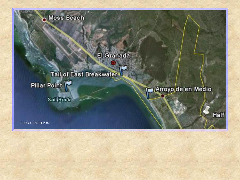
GOOGLE EARTH: 2007

Northern Half Moon Bay Shoreline Conditions
Relative to Construction at Pillar Point Harbor
Date Event Beach Condition
Prior to
1959
Natural Conditions Broad sandy beach with
cliff retreat of 3 in/yr and
an erosion rate of ~30,000
yd3/yr (throughout the
Bay)
1959 to
1961
Two Outer Breakwaters
Built
Transitional phase;
erosion rates increasing
Post 1961 Various remedial actions
including rubble-mound
revetments
Narrowing of the beach
with initial exposed sea-
cliff retreat up to 80 in/yr
and erosion rates up to
~75,000 yd3/yr
deposition on north side of
East Breakwater

PRIME, USGS: 1971

LAJOIE, USGS:1971
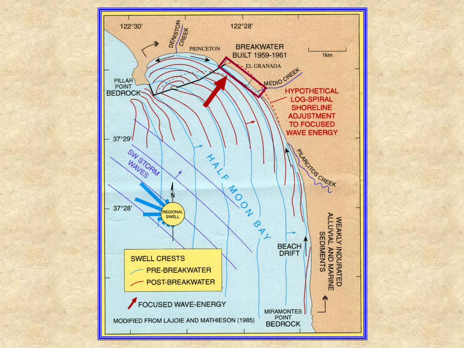

LAJOIE AND MATHIESEN USGS POSTER
LAJOIE AND MATHIESEN USGS POSTER


In conclusion, a preponderance of evidence substantiates the
claim that the construction of the East Breakwater led to a
dramatically increase in the erosion rate of the shoreline
between the root of the breakwater and Arroyo de en Medio.
Other causal effects, such as changes in weather patterns,
are thought to have made a minor contribution at best to the
increased erosion rate. Parts of the shoreline in question
were protected by rock and concrete periodically dumped
between 1959 and 1981. However, the erosion continued
and a more substantial rubble-mound revetment was
constructed in 1983 to protect Highway 1 where it passes
within 30 ft of the cliff edge. Erosion of the unarmored
shoreline continues.

Consequently, this Initial Appraisal supports the
conclusion reached by an earlier USACE study (1971):
“The District Engineer finds that the erosion problem
along the shores of El Granada Beach exists in two
forms: (1) the direct erosion of material from the low
bluffs immediately landward of the beach, and (2) the
loss of littoral material from the beach backshore. He
also finds that protective measures are required in the
reach of coast from the Half Moon Bay East Breakwater
to the mouth of the Arroyo de en Medio, approximately
4,600 feet to the southeast. No improvements are
justified along the remaining coastline studied as the
shoreline from Arroyo de en Medio to Miramontes Point
is not eroding substantially at this time.”
Note that further study will be required in any future
project to confidently prove and quantify the amount of
change caused by the outer breakwaters.