Embed Size (px)
Citation preview

Concept
Recreational Zone
5.36 This AAP seeks to promote the Lea Valley area as a regionalrecreational zone, where visitors and locals can come to interact withthe natural setting that is the Lee Valley Regional Park. The parkcurrently provides a range of recreational activities, however theenvironment around the Lea Bridge Road in this character area isdisjointed and there is a lack of integration around the ice rink, ridingcentre and other uses. The leisure facilities at Lea Bridge shouldcomplement and support one another so that visitors are drawn to thearea by the range of complementary and integrated uses and arecompelled to stay in the area for longer. These could include bothformal activities such as boat hire, ice skating, riding, and informalactivities such as walking or cycling. Access from Lea Bridge Roadinto the proposed Walthamstow Wetlands area is an importantrecreational opportunity.
Walthamstow Wetlands
5.37 The Walthamstow Wetlands project would improve access toapproximately 400 hectares of blue and green open spaces and helpdeliver convergence, increase the attractiveness of the area as a placeto live and visit and strengthen neighbourhood pride. Specifically, itaims create an urban wetland centre and nature reserve at the ThamesWater owned Walthamstow Reservoirs and to turn the extensivewaterscape into a regional destination, a valuable environmental andrecreational resource and a focus for learning for local people.
5.38 An integrated recreational zone could potentially be organisedfrom a central hub area in the vicinity of the Ice Rink. This wouldencourage visitors to spendmore time in the area and support greaterinteraction between existing activities to achieve multi-activity visits.
Accessing the Park
5.39 Access to and through the park should be improved toencourage informal use of Lea Bridge. Improved pedestrianconnections would encourage local community use of the park.Entrance points into the park should also be strengthened, withconsideration to both how local communities and regional visitors willaccess the park.
5.40 Strengthening the quality of routes and connections wouldencourage cyclists to use the park. Improved horse trails will alsoencourage the use of the park for recreational purposes.
5.41 Currently, the area suffers from low public transportaccessibility, and investment in this would greatly boost the use of thearea. Connections between the character area and public transportnodes (e.g. Clapton Station, local bus stops) should also bestrengthened. Links between Lea Bridge and Stratford should also beconsidered, particularly in terms of issues relating to re-opening LeaBridge Station.
Lea Bridge Road
5.42 Lea Bridge Road dissects the green nature of the Lea ValleyPark, and in its current state as a busy arterial road does not promotethe park as a place to visit, or its natural character. This AAP thereforeseeks to promote enhancements to Lea Bridge Road to create a morenatural and friendly setting, with open views to the north and southup and down the Lea Valley, creating a nature focused pedestrianand cycling experience along the valley crossing. Appropriate newdevelopment and public realm improvements would create a morepositive frontage onto the road, improve crossing conditions forpedestrians and strengthen the entrance into the park from the east,creating a gateway into the park.
Spatial Planning - London Borough of Waltham Forest58
Northern Olympic Fringe AAP Proposed Submission

Underutilised Metropolitan Open Land
5.43 This AAP supports the opening up of any Metropolitan OpenLand sites that are currently not for public use. Where it is appropriate,the Council supports the development of compatible uses to enablethis to be achieved.
Lea Bridge Station
5.44 The re-opening of Lea Bridge station, will be important to thepromotion of Lea Valley character area as an attraction for people.The reopening of the station would create the following regional andlocal benefits:
Improving accessibility to public transport to and from Lea Bridge,creating a direct rail link between Chingford and Liverpool StreetviaWalthamstow Central and Stratford. There may also be furtherconnections to the Stratford and Broxbourne services viaTottenham Hale;Wider sub-regional benefits would include new links to StanstedAirport (via Chingford), which is an hour away from Lea Bridge;Strengthening rail connections would increase the catchmentarea for the park, making it more accessible for a greaterpopulation. It would encourage existing residents in Stratford andNewham to visit and use the park on a more regular basis.The station would also benefit the new communities housed inthe mixed use development proposed as part of the planningframework and the additional residents living in the OlympicVillage;The re-opening of the station would create a sustainabledestination for those looking to access new leisure activities andopen spaces close to their homes. The station is within an eightminute walk of many of the leisure facilities along Lea BridgeRoad, including the Lea Valley Park and Trail, WaterworksCentre, Golf Centre and Riding Centre. The Regional Ice Centrerink is also within walking distance of the station. Improving the
rail links would widen the appeal of these attractions, and promotea modal shift from the use of the car onto rail;Re-opening the station would also have a positive impact uponthe industrial areas clustered around the station. Improvedaccessibility of the area would encourage businesses to locateat Lea Bridge, and would support workers and visitors to theindustrial areas.
TottenhamHale
SevenSisters
BlackhorseRoad
CentralLeeside
Walthamstow
StokeNewington
Clapton
HackneyMarshes
Mill Fields
SpringfieldPark
SpringfieldMarina
WalthamstowStreet Market
Low HallFields
WalthamstowMarhses
MiddlesexFilter Beds
pub
EssexFilter BedsNature Reserve
LVRPAGolf Course
Ice Rink
EquestrianCentre
filter beds
Eyre
Markfield ParkBeam EngineMuseum
TottenhamMarshes
The
DownLanePark
TottenhamHigh Road
MarineEngineHouse
Listed
Banbury Reservoir
WestWarwickReservoir
WestWarwickReservoir
WalthamstowReservoirs
MaynardReservoirs
LockwoodReservoirs
StonebridgeLock
WildMarshEast Wild
MarshWest
A406
Underground Stations
Future development
Walthamstow Reservoirs Site Boundary
Activity Cluster
New Valley Routes
N200m 500m 1km
New Entry Points
althamstow Wetlands
Douglas
Fields
Paddock
Ferry Boat Inn
Copper Mill
Picture 5.9 Walthamstow Wetlands
59Spatial Planning - London Borough of Waltham Forest
Northern Olympic Fringe AAP Proposed Submission
Lea Bridge
Policy NOF5 - Lea Bridge Character Area
The Council will seek co-ordinated redevelopment of theopportunity sites within the Lea Bridge character area andrecognise that in the Lea Bridge character area:
a. There is an important function as an industrial area and theCouncil will work to retain, intensify, support and enhancethese uses;
b. New development around the Lea Bridge neighbourhoodcentre should promote the area as a gateway into theBorough and improve the public realm;
c. Area for taller buildings of 5 to 7 stories to be considered atthe gateway site along Lea Bridge Road; and
d. Heritage assets such as the Pump House (Grade II ListedBuilding) and its setting should be appropriately conserved( see site policy NOF5: site 11).
Introduction
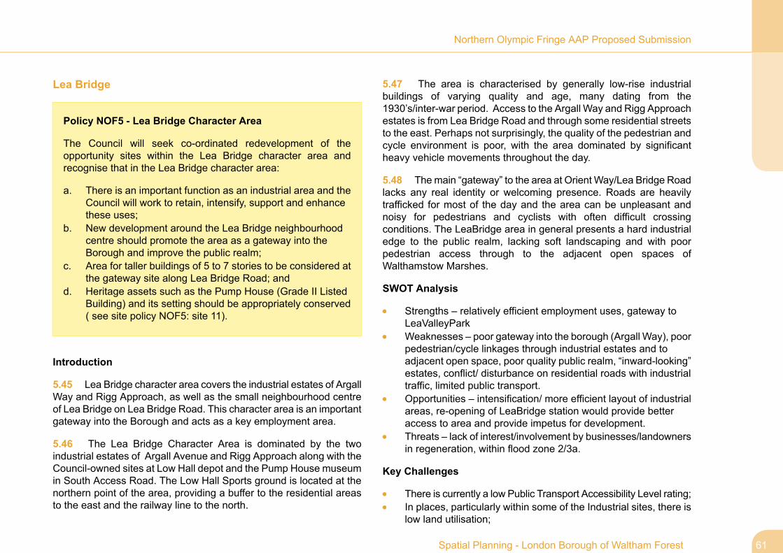
5.45 Lea Bridge character area covers the industrial estates of ArgallWay and Rigg Approach, as well as the small neighbourhood centreof Lea Bridge on Lea Bridge Road. This character area is an importantgateway into the Borough and acts as a key employment area.
5.46 The Lea Bridge Character Area is dominated by the twoindustrial estates of Argall Avenue and Rigg Approach along with theCouncil-owned sites at Low Hall depot and the Pump House museumin South Access Road. The Low Hall Sports ground is located at thenorthern point of the area, providing a buffer to the residential areasto the east and the railway line to the north.
5.47 The area is characterised by generally low-rise industrialbuildings of varying quality and age, many dating from the1930’s/inter-war period. Access to the Argall Way and Rigg Approachestates is from Lea Bridge Road and through some residential streetsto the east. Perhaps not surprisingly, the quality of the pedestrian andcycle environment is poor, with the area dominated by significantheavy vehicle movements throughout the day.
5.48 Themain “gateway” to the area at Orient Way/Lea Bridge Roadlacks any real identity or welcoming presence. Roads are heavilytrafficked for most of the day and the area can be unpleasant andnoisy for pedestrians and cyclists with often difficult crossingconditions. The LeaBridge area in general presents a hard industrialedge to the public realm, lacking soft landscaping and with poorpedestrian access through to the adjacent open spaces ofWalthamstow Marshes.
SWOT Analysis
Strengths – relatively efficient employment uses, gateway toLeaValleyParkWeaknesses – poor gateway into the borough (Argall Way), poorpedestrian/cycle linkages through industrial estates and toadjacent open space, poor quality public realm, “inward-looking”estates, conflict/ disturbance on residential roads with industrialtraffic, limited public transport.Opportunities – intensification/ more efficient layout of industrialareas, re-opening of LeaBridge station would provide betteraccess to area and provide impetus for development.Threats – lack of interest/involvement by businesses/landownersin regeneration, within flood zone 2/3a.
Key Challenges
There is currently a low Public Transport Accessibility Level rating;In places, particularly within some of the Industrial sites, there islow land utilisation;
61Spatial Planning - London Borough of Waltham Forest
Northern Olympic Fringe AAP Proposed Submission
As a gateway into the Borough, particularly around the old LeaBridge Station, the gateway sites are of poor quality;The quality of the public realm along Lea Bridge is poor.
Picture 5.11
Objectives
5.49 The Objectives for the Lea Bridge neighbourhood are asfollows:
Activation of Lea Bridge Road through development and publicrealm improvements;Promotion of the role of the Lea Bridge neighbourhood centre;Development of key landmark sites such as the Bingo Hall onthe corner of Church Road and Lea Bridge Road, and 97 LeaBridge Road;Rationalisation and intensification of industrial units around theArgall Estate and Rigg Approach to promote further industrialuses.Improving the key gateways into the borough, particularly at ArgallWay/Orient Way, through major public realm improvements andlandscaping.Introduction of appropriate traffic calming measures alongresidential streets which currently carry significant amounts ofindustrial traffic.Improving the frontages of industrial estates onto the public realm,particularly at Rigg Approach.
Spatial Planning - London Borough of Waltham Forest62
Northern Olympic Fringe AAP Proposed Submission

Figure 5.4 Design Principles for Lea Bridge Character Area
63Spatial Planning - London Borough of Waltham Forest
Northern Olympic Fringe AAP Proposed Submission

Concept
Strategic Employment Land
5.50 Waltham Forest’s Employment Land Study (October 2009)supports the retention of the majority of industrial land uses in the LeaBridge Road area, and the employment areas around Argall Way,Rigg Approach and Lammas Road which are currently well occupiedand offer a diverse range of employment uses. These should beimproved and retained as Strategic Industrial Land. Unfortunately, thequality of many of the industrial areas is not high. The Argall area (themain industrial park) has little street activity and provision forpedestrians. Given the size and accessibility of the land at RiggApproach, it has been identified as Waltham Forests’s only potentialwaste site within the North London Waste Strategy DPD (preferredoption). However, the final approved DPD will determine the futureuse of this site. Strategic employment lands will be retained andenhanced to promote further employment uses, with the exception of97 Lea Bridge Road which is being proposed for de-designation inline with the recommendations of the Council's Employment LandStudy (2009).
Lea Bridge Neighbourhood Centre
5.51 The Council will promote the local functions of the Lea BridgeNeighbourhood Centre, with improvements to the public realm andan improvement of the key landmarks such as the Bingo Hall. A purelyretail development is unlikely to be a commercially viable prospect atpresent and a mixed-use development appears more feasible.Stimulating retail demand in the area is more likely to rest onimprovements to existing centres rather than expansion, which couldinclude shopfront and streetscape improvements, as well as possiblycreating larger units to attract operators who often favour smallercentres.
Spatial Planning - London Borough of Waltham Forest64
Northern Olympic Fringe AAP Proposed Submission


Spatial Planning - London Borough of Waltham Forest66
Northern Olympic Fringe AAP Proposed Submission

Key Opportunities Sites
67Spatial Planning - London Borough of Waltham Forest
Northern Olympic Fringe AAP Proposed Submission

6 Key Opportunities Sites6.1 Introduction
6.2 A range of opportunity sites has come forward through previousconsultation. The sources of these include the:
Leyton Area Action Plan Scoping Studying July 2006Northern Olympic Fringe Master Plan November 2009Borough wide 'Call for Sites' summer of 2009Lea Bridge Area Issues and Options Consultation July 2009Northern Olympic Fringe Preferred Options Consultation January2011Ongoing discussions with landowners and stakeholders
6.3 This section sets out proposed uses for these sites, based onwhat is considered an appropriate use of land and securingregeneration benefits for the wider area. Proposed uses have beenthe subject of ongoing discussions with relevant landowners.
6.4 Where figures are provided of employment floorspace or numberof residential units, these provide a broad indication of what we thinkthe capacity of the site may be, based onmatters such as PTAL (PublicTransport Accessibility Level) ratings, pre-application discussions,and surrounding uses. However, at the detailed design state, futureplanning applications may be able to justify higher figures, whilst stillachieving a high quality development.
6.5 Figure 4.1 of this document shows where within the AAP eachkey site is located. It is not an exhaustive list and over the plan periodfurther opportunity sites may come forward.
Site Policy NOF2: Site 1 - Drapers Fields
Policy NOF2: Site 1 - Drapers Fields
Enhancement of Open Space for outdoor recreational use.(Site Area - 3 hectares)
1. Development proposals for the redevelopment of the site shouldcontain the following:
a. The site should serve as a significant ‘gateway’ to theOlympic Park after the 2012 Games, sitting as it does on akey east-west route linking the Olympic Park withWansteadFlats to the east, and Hackney Wick/Victoria Park to thewest.
b. It should feature strongly in the routes to and from the newChobham all-age academy located within the Athletes Villagedevelopment.
c. Temple Mills Lane should provide access into this area aspart of the Olympic Park transformation and Legacy works.This will alter movement patterns along Temple Mills Lane,and the existing access point opposite Leyton Road mayneed to be altered.
d. Brief views towards the Olympic Park should be enhancedto improve legibility from High Road Leyton.
e. Open and frame views into the Olympic and Lea Valley Parkshould be enhanced .
f. Alter access points at Temple Mills Lane to take account ofchanges in movement patterns brought about by the Olympicimprovement works.
Spatial Planning - London Borough of Waltham Forest68
Northern Olympic Fringe AAP Proposed Submission

g. Enhance recreational facilities within the open space andconsider ancillary building uses that will bring activity atdifferent times of the day.
h. The pavement and road narrows at the bridge adjacent tothe site should be improved. Beyond the bridge the qualityof the environment for pedestrians should be improved.
i. The High Road Leyton edge of the site is distinctive,predominantly due to the line of trees and Victorian railings,this character should be retained and where necessaryimproved.
6.6 Character area - Leyton
6.7 Current use - Playing field with AGP, 2x grass pitches and 2xpavilions.
6.8 Context - The eastern edge of this playing field site is definedby High Road Leyton and the area beyond is predominantly residentialin character. To the west lies the Cheshunt/Stansted Airport toStratford railway line and behind that lies the Olympic Park. Thesouthern boundary is defined by Temple Mill Lane and follows the lineof the Waltham Forest/Newham borough boundaries.
The site is within 10minutes walking distance of Leyton neighbourhoodcentre and Leyton tube station. Westfield Stratford City and StratfordInternational station are both approximately 10-15 minutes’ walk away.
6.9 PTAL - 6a/5
6.10 Character area/site opportunities and challenges
Lack of activity – The open space currently lacks activitygenerating uses at its edges.
Distinctive edge - The Victorian railings and row of matureLondon planes provide a distinctive edge along High Road Leytonto the open space. The railings are run down and in need ofrepair.
Parking - The site lies within Crownfield Road controlled parkingzone (CPZ).
69Spatial Planning - London Borough of Waltham Forest
Northern Olympic Fringe AAP Proposed Submission

Picture 6.1 NOF Site 1 - Drapers Fields
Spatial Planning - London Borough of Waltham Forest70
Northern Olympic Fringe AAP Proposed Submission

Site Policy NOF2: Site 2 - ChobhamAcademy Playing Fields
Policy NOF2: Site 2 - Chobham Academy PlayingFields
New playing fields with community use as part of ChobhamAcademy. (Site Area - 2.85 hectares)
1. Development should achieve and contribute to the following:
a. The openness of the Lee Valley Regional Park should besafeguarded and this site should be designed andmanagedto enhance its ecological potential.
b. The Council should seek to maintain the open character ofthis land and therefore any proposed buildings should belimited in scale and carefully sited.
c. Should the proposed bridge across the Cheshunt/StanstedAirport to Stratford railway line be made from Leyton Mills,the site could then connect to Leyton Neighbourhood Centreto the north along Temple Mills Lane.
d. Routes from the proposed Academy should be enhancedfor pedestrians and cyclists.
e. As this site is at the borough, Olympic and Lee ValleyRegional Park gateways, key points at the edge of the siteshould be improved. This should include the planting oftrees, high quality landscaping or public art.
f. Improvements should be made to the public realmsurrounding the site including enhancements for pedestriansand cyclists. If any ancillary buildings are proposed for thesite, they should be designed to bring activity to thesurrounding streets as well as the open space.
g. A preliminary site evaluation would be required beforedevelopment proposals are considered.
h. The site should create a suite of high-quality sportingfacilities serving the academy and local community.
6.11 Character area - Leyton
6.12 Current use - Within the Olympic Park, under construction.
6.13 Context - This triangular site lies to the south of the boroughon the boundary with Newham, and is defined by Temple Mills Laneto the west and south and the Cheshunt/Stansted Airport to Stratfordrailway line to the east. The site is within the Olympic Park and LeeValley Regional Park, and is within 10 minutes walking distance ofLeyton Neighbourhood Centre. The nearest stations are Leyton andStratford International, and Westfield Stratford City is a short walkaway.
6.14 PTAL - 4/5
6.15 Character area/site opportunities and challenges
Lee Valley Regional Park – This site is within the Park.
Metropolitan Open Land (MOL) – The site is designated as theTemple Mills MOL.
71Spatial Planning - London Borough of Waltham Forest
Northern Olympic Fringe AAP Proposed Submission
Severance – The Cheshunt/Stansted Airport to Stratford railwayline restricts movement to east, however this line is bridged tothe south-east of the site. Links to Leyton Neighbourhood Centrecannot currently be made from the north of the site.
ChobhamAcademy - The academy is approximately 2-3minuteswalking distance from the playing fields, and some of the roadsalong the route to it have little natural surveillance and feel unsafe.
Gateway site – This site lies on a gateway to the borough, theOlympic Legacy area, and the Lee Valley Regional Park.
Public realm –Temple Mills Lane that edges the site to both thewest and south has the character of a service road with very littleactivity at its edges making it feel unsafe. Footways adjacent tothe site are either not present or are narrow, and where they arepresent they are shared with cyclists. Neither the pedestrian norcycling environment is of high quality.
Flood zone – The site is within flood zone 2.
Archaeological Priority Zone (APZ) – The site lies within APZ1.
Spatial Planning - London Borough of Waltham Forest72
Northern Olympic Fringe AAP Proposed Submission

Picture 6.2 NOF Site 2 - Chobham Academy
73Spatial Planning - London Borough of Waltham Forest
Northern Olympic Fringe AAP Proposed Submission

Policy NOF2: Site 3 - Eton Manor
Policy NOF2: Site 3 - Eton Manor
Olympic Legacy upgrades including hockey, football andtennis areas and possible re-located allotments/communitygardens. (Site Area- 11 hectares)
1. Development should achieve and contribute to the following:
a. The Lea Valley Pathway Corridor gateway (western cornerof the site) should be improved to create a focal point whichannounces and raises the profile of the regional park. Theopenness of the Lee Valley Regional Park should also besafeguarded and this site should be designed andmanagedto enhance its ecological potential.
b. The Council should seek to maintain the open character ofthis land and therefore any proposed buildings should belimited in scale and carefully sited.
c. The trees that are subject to preservation orders should beprotected and retained. Therefore these trees should notbe felled, lopped, topped, uprooted or damaged and theCouncil should be consulted prior to any works taking placeon or near the trees.
d. Improved cycle and pedestrian links should be made toLeyton Neighbourhood Centre to the east and to Stratfordand the Olympics to the south and west.
e. Improvements should be made to the public realmsurrounding the site, and smaller scale uses such ascommunity gardens or any proposed ancillary buildingsshould be designed to bring activity to the surroundingstreets as well as the open space.
f. A preliminary site evaluation would be required beforedevelopment proposals are considered.
6.16 Character area - Leyton
6.17 Current use - Within the Olympic Park, currently underconstruction.
6.18 Context - This site lies on the south-eastern edge of WalthamForest on the borough boundaries with Newham and Hackney. It iswithin the Olympic Park and Lee Valley Regional Park and thewestern-most point is one of the key entrance points to the Lea ValleyPathway Corridor. The site is defined by Ruckholt Road to the north,Temple Mills Lane to the east and the A12 to the south. The site isapproximately 15-20 minutes walking distance to Westfield StratfordCity and the nearest station is Leyton which is approximately 10minutes walking distance away. Stratford International Station is alsoapproximately 10 minutes walking distance away.
6.19 PTAL - The PTAL of the site varies from 1b in the south, 2 tothe west and north and 5 to the east.
6.20 Character area/site opportunities and challenges
Lee Valley Regional Park – This site is within the Park and thewestern corner is identified in the Lee Valley Regional Park Planas one of the key entrances to the Lea Valley Pathway Corridor.The Pathway Corridor runs along the western edge of the sitealong the old Quartermile Lane.
Spatial Planning - London Borough of Waltham Forest74
Northern Olympic Fringe AAP Proposed Submission

Metropolitan Open Land (MOL) – The site is currentlydesignated as the Quartermile Lane MOL.
Preserved trees - There are a number of trees with PreservationOrders on the site (see attached plan).
Severance – The site is currently segregated from Stratford bythe A12 and from Leyton Neighbourhood Centre by theCheshunt/Stansted Airport to Stratford railway line.
Public realm – The roads surrounding the site have beendesigned for vehicles. They are not of a pedestrian scale andhave little activity at their edges making them feel unsafe. TempleMills Lane is a good example of this where the site is edged bya high brick wall offering no views or activity from the open space.The A12 is also elevated in relation to the site and therefore is adominant feature to the south.
Flood zone – Part of the site is within flood zone 2.
Crossrail 2 safeguarding zone – The north-west of the site iswithin the safeguarding zone.
Archaeological Priority Zone (APZ) – The site lies within APZ1.
75Spatial Planning - London Borough of Waltham Forest
Northern Olympic Fringe AAP Proposed Submission

Picture 6.3 NOF Site 3 - Eton Manor
Spatial Planning - London Borough of Waltham Forest76
Northern Olympic Fringe AAP Proposed Submission
Policy NOF2: Site 4 - Leyton Mills / Asda Site
Policy NOF2: Site 4 - Leyton Mills / Asda Site
Mixed use site including retail / residential / socialinfrastructure to incorporate a pedestrian and cycle bridgelink to Eton Manor. (Site Area - 9.34 hectares)
1. Development should achieve and contribute to the following:
a. Proposals should be developed to improve connections withthe High Road both in terms of access.
b. Proposals should include development plans that bridgeover the railway linking the western edge of the site to EtonManor. The treatment of this bridge needs to be carefullyconsidered to ensure it does not create hostile or awkwardspaces at its base. Proposed buildings should be orientatedto bring activity and natural surveillance to this link.
c. The Council may seek contributions towards improvementsto Leyton station.
d. Building heights near the High Road should be kept to 3storeys to respect the context, amenity and privacy ofresidential neighbours (although a higher landmark buildingcould possibly be located towards the railway edge).Building heights could be higher towards the southern andwestern edges of the site. Taller buildings for 7 to 10 storeyswould be considered at appropriate locations. Any residentialdevelopment towards the south-eastern or south-western
edges of the site will need to consider the impact of trafficnoise from the A12 and railway line, and an appropriatenoise assessment is likely to be required.
e. Intensification with mixed uses and appropriate orientationof buildings should improve natural surveillance.
6.21 Character area - Leyton
6.22 Current use - Mixed use retail park.
6.23 Context - The site is close to the borough boundaries withNewham and Hackney. It lies within Leyton Neighbourhood Centreand the main pedestrian entrance is opposite Leyton tube station.Vehicular access if via Marshall Road to the west, and many of theretail units currently cater predominantly to car users. The surroundingarea is predominantly residential in character and there are parks andopen spaces within a 10 minute walk. The south-eastern andsouth-western edges of the site are severed from neighbouring areasby the A12 and the Stratford to Cheshunt/Stansted Airport railwayline. Stratford International Station and Westfield Stratford City areapproximately 15-20 minutes walk away.
6.24 PTAL - The PTAL of the site varies from 6a near High RoadLeyton to 1a at the southern corner of the site.
6.25 Character area/site opportunities and challenges
Public realm – The quality of the public realm on High RoadLeyton is poor in places, and there is a poor interface betweenthe High Road and the site.
Out of town character - Despite being within Leyton’sNeighbourhood Centre, the retail park has an out-of-towncharacter, with most visitors arriving by car.
77Spatial Planning - London Borough of Waltham Forest
Northern Olympic Fringe AAP Proposed Submission

Severance – The site is severed from Lea Valley Park, OlympicPark and Stratford by the railway and A12.
Leyton Station - Leyton station is overcrowded at peak times.
Antisocial behaviour - The area is affected by antisocialbehaviour.
2 storey neighbours - 2 storey residential neighbours near theHigh Road Leyton edge of the site are likely to affect buildingheights in that area.
Traffic noise - Traffic noise from the A12 can be heard on thesite.
Levelling ponds - There are 2 levelling ponds on the site thatmay affect development.
Flood zone - The south western edge of the site is within floodzone 2.
Spatial Planning - London Borough of Waltham Forest78
Northern Olympic Fringe AAP Proposed Submission

Picture 6.4 NOF Site 4 - Leyton Mills / ASDA Site
79Spatial Planning - London Borough of Waltham Forest
Northern Olympic Fringe AAP Proposed Submission

Policy NOF2: Site 5 - Ruckholt Road
Policy NOF2: Site 5 - Ruckholt Road
Mixed use / residential. Artist studios. (Site Area - 0.76hectares)
1. Development should achieve and contribute to the following:
a. The proposed Crossrail tunnel may affect the design ofunderground structures and foundations.
b. As this is a prominent site close to the borough boundaryand Olympic Park/Legacy area, it should be suitable for alandmark building that is distinctive but which still respectsits context.
c. Building heights on this site should range between 2 and 5storeys. This should enable the development to compliment2-storey neighbours yet still respond to its prominent location.
d. Proposed development should improve the interface withthe public realm on Ruckholt Road and at the junction ofOliver Road which may require adjustment of levels at thisedge. Footways along Ruckholt and Oliver Road should bewidened as part of any development.
e. A preliminary site evaluation may be required beforedevelopment proposals are considered.
6.26 Character area - Leyton
6.27 Current use - Nissan Car dealership.
6.28 Context - This triangular, gateway site on Ruckholt Road isnear the borough boundary with Hackney. It is in a prominent locationat a bend in the road and lies within a predominantly residential area.It is approximately 5 minutes walking distance of LeytonNeighbourhood Centre and the Lee Valley Regional Park, and is within10 minutes walking distance of Leyton tube station.
6.29 PTAL - 6a/5
6.30 Character area/site opportunities and challenges
1. Crossrail 2 safeguarding zone – The site lies within theCrossrail 2 safeguarding zone and Crossrail plan to tunnel at thislocation.
d. Prominent site – The site sits on a bend on Ruckholt Road andis therefore visually prominent.
e. Proximity to Olympic park/Legacy area – The site is close toRuckholt bridge which provides a link to the Olympic park/Legacyarea. As this is a prominent site, it provides an opportunity tohelp create a dynamic stepping stone between the Legacy areaand Waltham Forest.
f. Public realm – The site is currently elevated above the footwayat the Ruckholt Road edge andOliver Road junction. The existingbuilding is also set back, both of which reduce the site’sconnection with Ruckholt Road. Furthermore, the footways onRuckholt and Oliver Road are relatively narrow, particularly atthe bus stop outside the site.
Spatial Planning - London Borough of Waltham Forest80
Northern Olympic Fringe AAP Proposed Submission

g. 2 storey neighbours – There are two 2-storey residentialproperties immediately adjacent to the site. Where these remainoutside the development area, building heights at this edge shouldrespond to these properties and their amenity and privacyrespected. Scope for approximately up to 116 residential units.
h. Archaeological Priority Zone (APZ) – The site lies within APZ1.
81Spatial Planning - London Borough of Waltham Forest
Northern Olympic Fringe AAP Proposed Submission

Picture 6.5 NOF Site 5 - Ruckholt Road
Spatial Planning - London Borough of Waltham Forest82
Northern Olympic Fringe AAP Proposed Submission

Policy NOF2: Site 6 - High Road Leyton/ Grange Park Road
Policy NOF2: Site 6 - High Road Leyton / GrangePark Road
Opportunity for enhancement / mixed use / residential. (SiteArea - 0.93 hectares)
1. Development should achieve and contribute to the following:
a. The site is in a highly visible location on the junction of threeof the borough's principal roads, and the south of the site isaccessible to public transport, it would be appropriate for ataller landmark building. The existing Lion and Key pubprovides an appropriate landmark at the junction of HighRoad Leyton and Church Road, a new landmark could becreated at the junction of High Road Leyton and GrangePark Road. Due to the high profile nature of this site, a highquality of design and architecture should be required for anyproposed development.
b. The main interest of the Lion and Key pub building is theoriginal Victorian section, it is important that anyimprovements or extensions to the pub retain the Victorianpart of the building as the tallest and most dominant element.
6.31 Character area - Leyton
6.32 Current use - Redundant retail site.
6.33 Context - This triangular site is bounded by Church Road atthe north, High Road Leyton to the east and Grange Park Road to thewest. It includes the Lion and Key pub which is locally listed. The sitelies within 5 minutes walking distance of Francis Road and Leyton
Neighbourhood Centres, and is approximately 10 minutes walkingdistance of Leyton Midland train station. Leyton tube station is within15 minutes walk.
6.34 PTAL - 3 at the northern edge of the site /6a towards the south.
6.35 Character area/site opportunities and challenges
Landmark site – This site lies on the junction of three of theborough's principal roads and the junction points are highlyvisible.
Local listing – The Lion and Key pub which is located on thenorth-eastern edge of the site is locally listed. The main interestof the local listing is the original Victorian section of the buildingholding the lion statues.
Public realm – There are a number of Victorian buildings thatbring richness and interest to High Road Leyton, but they are rundown and lower the quality of the public realm. There are alsoa number of street signs, particularly on High Road Leyton thatbring clutter to the street and reduce the width of the footway.There are few street trees around the periphery of the site tosoften the built form. Scope for approximately up to 60 residentialunits. Any land mark building may be appropriate with amaximum building height of 5 storeys.
Archaeological Priority Zone (APZ) – The site lies within APZ16.
83Spatial Planning - London Borough of Waltham Forest
Northern Olympic Fringe AAP Proposed Submission

Picture 6.6 NOF Site 6 - High Road Leyton / Grange Park Road
Spatial Planning - London Borough of Waltham Forest84
Northern Olympic Fringe AAP Proposed Submission

Policy NOF2: Site 7 - Bywaters Site - Auckland Road
Policy NOF2: Site 7 - Bywaters Site - Auckland Road
Redeveloped waste facility possibly including mixed use /residential / social infrastructure. (Site Area - 5.22 hectares)
1. Development should achieve and contribute to the following:
a. Improving the layout and block structure as part ofredevelopment in this site would help to increase the legibilityand improve connections within the area. Access for anyproposed waste facility where lorries will be entering the sitemay be from Orient Way due to its scale and character.Contributions may be sought for improvements to OrientWay to make it less hostile for pedestrians and cyclists.East-western connections should be made to improvepermeability particularly for cyclists.
b. Any proposed residential or social infrastructure uses maybe located to the north and east of the site and any proposedwaste facility may be located to the south and west. Thisfollows appropriate points of access and ensures anyresidential development is located away from the flood zone.Developers should consider the impact of the Score Centrepitch floodlighting on any proposed residential neighbours.
c. Proposed development should not create any adverse impacton the character of the houses on Osier Way and DunedinRoad.
d. Significant trees along the periphery of the site should beretained. Consideration should also be given to theecological value of hedgerows when determining whichshould be retained or removed.
e. A preliminary site evaluation would be before developmentproposals are considered.
f. Ground contamination is likely to have occurred, and willneed remediation.
6.36 Character area - Leyton
6.37 Current use - Waste management facility.
6.38 Context - The site is within 10 minutes walking distance ofLeyton tube station, Leyton Neighbourhood Centre and the Lee ValleyRegional Park. It is also within 5 minutes walking distance ofCoronation Gardens and Leyton Orient football ground. It is boundedby Orient Way to the south-west, allotments to the south-east andnorth-west, and the Score community centre to the north-east.
6.39 PTAL - Ranges between 1b and 4.
6.40 Character area/site opportunities and challenges
Movement - The character of Orient way is industrial and ishighway dominated. There is little activity along its edges. Thereare few east-west links to the north of the site reducing thepermeability of the area. The streets to the north and east areresidential in character.
Water overflow – The Thames Water owned part of the sitecontains a storm water overflow. Development here would besubject to the water overflow being capped or relocated.
Mature trees – There are a number of mature trees edging thesite that merit retention.
85Spatial Planning - London Borough of Waltham Forest
Northern Olympic Fringe AAP Proposed Submission

Waste facility – The existing waste facility is noisy and its edgeon Osier Way sits awkwardly with residential neighbours.
Score centre – The pitch is flood lit which may affect proposedneighbouring uses.Flood plain – The south-western edge of this site is within floodzone 2.
Archaeological Priority Zone (APZ) – The site lies within APZ1.
Spatial Planning - London Borough of Waltham Forest86
Northern Olympic Fringe AAP Proposed Submission

Picture 6.7 NOF Site 7 - Bywater Site - Auckland Road
87Spatial Planning - London Borough of Waltham Forest
Northern Olympic Fringe AAP Proposed Submission

Policy NOF2: Site 8 - SCORE Centre
Policy NOF2: Site 8 - SCORE Centre
Improvement to existing facilities. (Site Area - 3.02 hectares)
1. Development should achieve and contribute to the following:
a. Connections should be improved in conjunction withdevelopment of the Bywaters site.
b. Developers would be required to provide contributionstowards improving the route for pedestrians and cyclists tothe recreational facilities of the Olympic Legacy Area andthe Lee Valley Regional Park. This would focus aroundRuckholt Road.
c. The currently unused parcel of land in the south of the siteshould be brought back into use for sport or communityactivities. These activities should also seek to improvenatural surveillance along Auckland Road and Oliver Road.
d. Consideration should be given to the impact of noise fromthe Bywaters site when considering development of this site.
6.41 Character area - Leyton
6.42 Current use - Community sports facility with AGP and indoorhalls.
6.43 Context - This rectangular site is immediately opposite toLeyton Orient football ground and is accessed from Oliver Road. Itcurrently houses the relatively modern Score Centre building, sportspitches, children’s play area and car park. The site lies to thenorth-east of the Bywaters waste facility and is 10 minutes walking
distance from Leyton tube station. The Olympic and Lee ValleyRegional Parks are also approximately 10 minutes walking distanceaway and Leyton Neighbourhood centre is approximately 5 minutesaway.
6.44 PTAL - The PTAL of the site varies from 2 in the north to 5 inthe south.
6.45 Character area/site opportunities and challenges
Movement& public realm – This site, in conjunction with theadjacent waste facility, restricts north-south movement in theimmediate area. Connections in the area are also restricted inan east-westerly direction at Osier Way. Access to therecreational facilities of the Olympic Legacy Area and Lee ValleyRegional Park would bemade via Ruckholt Road which currentlyprovides a poor environment for pedestrians and cyclists.
Underused land – The southern part of the site is currently notused.
Bywaters site – The existing waste facility at the adjacentBywater site is noisy.
Spatial Planning - London Borough of Waltham Forest88
Northern Olympic Fringe AAP Proposed Submission

Picture 6.8 NOF Site 8 - SCORE Centre
89Spatial Planning - London Borough of Waltham Forest
Northern Olympic Fringe AAP Proposed Submission
Policy NOF2: Site 9 - Leyton Orient Football Club
Policy NOF2: Site 9 - Leyton Orient Football Club
Improvement to existing facilities. (Site Area - 2.07 hectares)
1. Development should achieve and contribute to the following:
a. Any improvements to facilities should seek to improve activityand natural surveillance on adjacent streets.
b. Developers may be required to provide contributions towardsimproving the route for pedestrians to and from Leytonstation and for pedestrians and cyclists to the OlympicLegacy Area and the Lee Valley Regional Park.
6.46 Character area - Leyton
6.47 Current use - Football stadium with residential units.
6.48 Context - This rectangular site comprises Leyton Orient footballstadium with residential blocks at its edges. The area is generallyresidential in character with Coronation Gardens to the south and theScore community and sports centre to the west. Oliver Road,Buckingham Road and Brisbane Road define 3 edges of the site andthe rear gardens of properties on Windsor Road define the remainingedge. Leyton tube station and the Olympic and Lee Valley RegionalParks are approximately 10 minutes walking distance away, andLeyton Neighbourhood centre is within 5 minutes on foot.
6.49 PTAL - 5
6.50 Character area/site opportunities and challenges
Ground floor activity – The existing arrangement brings littleground floor activity and natural surveillance to adjacent streetsdue to the undercroft car parking arrangement and location ofthe football pitch.Public realm and Leyton Station – Visitors travelling to thestadium are likely to arrive at Leyton station which is overcrowdedat peak times. The quality of the public realm along the routefrom the station is being improved particularly on High RoadLeyton by the station. Movement towards the recreationalfacilities of the Olympic Legacy Area and Lee Valley RegionalPark would be made via Ruckholt Road which is being improvedto provide a better environment for pedestrians and cyclists.
Spatial Planning - London Borough of Waltham Forest90
Northern Olympic Fringe AAP Proposed Submission

Picture 6.9 NOF Site 9 - Leyton Orient Football Club
91Spatial Planning - London Borough of Waltham Forest
Northern Olympic Fringe AAP Proposed Submission

Policy NOF3: Site 10 - Ive Farm Sports Ground
Policy NOF2: Site 10 - Ive Farm Sports Ground
Green space enhancement. (Site Area - 5.08 hectares)
1. Development should achieve and contribute to the following:
a. Small scale uses and ancillary buildings could be introducedto bring natural surveillance over the open space and IveFarm Lane. Connections to Marsh Lane playing fields andto Leyton Neighbourhood centre and the Olympic Parkshould be made safer. This could be achieved by cuttingback vegetation and improving visibility and openness, andwhere possible bring natural surveillance and overlookingfrom neighbouring uses. An additional connection to theopen space could be made from Ive Farm Close.
b. The brook should become a feature at the edge of the sportsground.
c. The Council will seek to maintain the open character of thisland and therefore any proposed buildings should be limitedin scale and carefully sited.
d. As much of the site is within flood zone 3a, any developmentproposals should be accompanied by an exception test.
e. A preliminary site evaluation would be required beforedevelopment proposals are considered.
6.51 Character area - Marsh Lane/Church Road
6.52 Current use - Unused playing field with small running track,pavilion and football pitches.
6.53 Context - This l-shaped site is broadly defined by DagenhamBrook and Marsh Lane playing fields to the west, Etloe Road industrialestate to the north and Oliver Road allotments to the south. To theeast of the site are a number of small social housing estates. Thenearest stations are Leyton Midland and Leyton which are bothapproximately 15-20 minutes walking distance away.
6.54 PTAL - 1b
6.55 Character area/site opportunities and challenges
Access – Whilst most of the site is currently closed, existingaccess to the site would be made from Ive Farm Lane. Otherroutes leading up to the open space such as Ive Farm Close andWalnut Road are cul-de-sacs and do not connect to the openspace. Ive Farm Lane feels very unsafe which is largely createdby inactive edges facing onto it. The link at the north-west of thesite over Dagenham Brook to Marsh Lane Playing fields isovergrown and feels very unsafe.
Natural surveillance over the open space – The propertiesedging the open space bring little natural surveillance with backgardens rather than front doors edging the space.Dagenham Brook – The brook runs along the western edge ofthe site and is an under-utilised resource within the site.Metropolitan Open Land (MOL) – This site is part of the LeytonMarshes Metropolitan Open Land.
Flood zone – A large area of the site is within flood zone 3a.
Archaeological Priority Zone (APZ) – This site is within APZ16.
Spatial Planning - London Borough of Waltham Forest92
Northern Olympic Fringe AAP Proposed Submission

Picture 6.10 NOF Site 10 - Ive Farm Sports Ground
93Spatial Planning - London Borough of Waltham Forest
Northern Olympic Fringe AAP Proposed Submission

Policy NOF5: Site 11 - Pump House Markhouse Avenue
Policy NOF2: Site 11 - Pump House MarkhouseAvenue
Residential / community uses. (Site Area - 0.42 hectares)
1. Development should achieve and contribute to the following:
a. Proposals with community uses must include a travel planwith any planning application.
b. The Grade II listed Pump House should be retained and anyalterations, extensions or proposed adjacent buildings mustbe of an appropriate scale and designed sensitively tocompliment the style and quality of the listed building.
c. A preliminary site evaluation would be required beforedevelopment proposals are considered.
d. Given the context and proximity of the Grade II listed PumpHouse, proposed building heights of 2/3 storeys may beappropriate. Development proposals should seek to increasethe activity at the edges of the site.
e. Access to the site from Brunel Road may be affected by thelevel difference between the road and the site and thereforeaccess may need to be achieved from Low Hall Lane and/orMarkhouse Avenue.
f. A root protection area will be required to protect the treeson the adjacent school site boundary.
6.56 Character area - Lea Bridge
6.57 Current use - Transport museum.
6.58 Context - The site lies on the edge of a predominantly 2 storeyresidential area with Barn Croft School immediately to the south ofthe site and Lloyd Park and the wider Lee Valley Regional Park to thewest. It is approximately 5 minutes walking distance from St James’Street Station and Lee Valley Regional Park. Queens Road Stationis just over 10 minutes walk away.
6.59 PTAL - 2
6.60 Character area/site opportunities and challenges
Public Transport Accessibility Level (PTAL) - The PTAL ofthe site is low.
Statutory listing - The Pump House to the east of the site isGrade II listed.
Archaeological Priority Zone (APZ) - The site lies within APZ1.
Level difference - Brunel Road is at a higher level than the site.
Public realm - Much of the public space around the site hasinactive edges with few windows and doors opening onto them.Scope for approximately up to 20 residential units.
Trees - Trees on site are not of significant value, but those offsite on the school boundary merit protection.
Spatial Planning - London Borough of Waltham Forest94
Northern Olympic Fringe AAP Proposed Submission

Picture 6.11 NOF Site 11 - Pump House
95Spatial Planning - London Borough of Waltham Forest
Northern Olympic Fringe AAP Proposed Submission

Policy NOF3: Site 12 - Marsh Lane Playing Fields
Policy NOF2: Site 12 - Marsh Lane Playing Fields
Opportunity for enhancement and increase in access, useand safety. (Site Area - 16.3 hectares)
1. Development should achieve and contribute to the following:
a. Proposals should seek to include small scale uses to theedges of the site to bring an activity. These should provideinformal surveillance over the park and adjacent streets, andpromote the interests and activities of the site. Theexpansive yards and security fencing along Orient Wayshould be improved along with the footbridge link acrossOrient Way into the Lee Valley Regional Park.Improvements should be made to provide easier accessalong the existing desire line from Seymour Road. Thisshould be revitalised as a key green link feature and a highquality riverbank area provided.
b. The Victorian building at the Marsh Lane entrance to thesite and avenue of trees along Marsh Lane should beretained as part of any improvement proposals.
c. Should any ancillary buildings be proposed, a preliminarysite evaluation would be required before developmentproposals are considered.
6.61 Character area - Marsh Lane / Church Road
6.62 Current use - Playing field with allotments and under-usedgrass pitches.
6.63 Context - This site lies in an area predominantly comprisingresidential and industrial uses. Dagenham Brook defines the easternboundary and Orient Way is on the southern boundary. Marsh Laneruns through the site in an east-westerly direction, and the neareststations are Leyton Midland and Leyton Underground which are bothover 20 minutes walking distance away.
6.64 PTAL - The PTAL of the site ranges from 1b to 2.
6.65 Character area/site opportunities and challenges
Public Transport Accessibility Level (PTAL) - The PTAL ofthe site is low. There are aspirations to reopen the redundantLea Bridge Station as part of the Hall Farm Curve reinstatement.Should the station be reopened the PTAL of the site wouldimprove.Public realm, access and safety – The site currently suffersfrom little natural surveillance. Uses surrounding the site includethe back gardens of houses on Clementina Road, LammasSchool, gas holders, marshalling yards, Ive Farm open spaceand industrial estates. None of these provide informalsurveillance over the playing fields. Access to the site is fromSeymour Road or Marsh Lane. The route along Marsh Lane tothe playing fields from Church Road also has little naturalsurveillance as residential properties back onto the road andschools and industrial areas are inward looking with blank edges.This leads to a site and access that feels unsafe. There is anexisting desire line from Seymour Road to the south of the siteon Orient Way. The interests and activities of the Marsh Laneplaying fields are not visible from Orient Way, and to the easternentrance via Marsh Lane itself. The quality of experience alongthe route to and on the footbridge over the marshalling yardsshould be improved.
Dagenham Brook - Dagenham Brook defines the eastern edgeof the site and is polluted and overgrown. It is an underutilisedresource within the site.
Spatial Planning - London Borough of Waltham Forest96
Northern Olympic Fringe AAP Proposed Submission

Existing buildings/trees - The Victorian building and avenue oftrees along Marsh Lane are assets to the site.
Flood zone – The site lies within flood zones 2 and 3a.
Archaeological Priority Zone (APZ) – This site is within APZ16.
97Spatial Planning - London Borough of Waltham Forest
Northern Olympic Fringe AAP Proposed Submission

Picture 6.12 NOF Site 12 - Marsh Lane Playing Fields
Spatial Planning - London Borough of Waltham Forest98
Northern Olympic Fringe AAP Proposed Submission

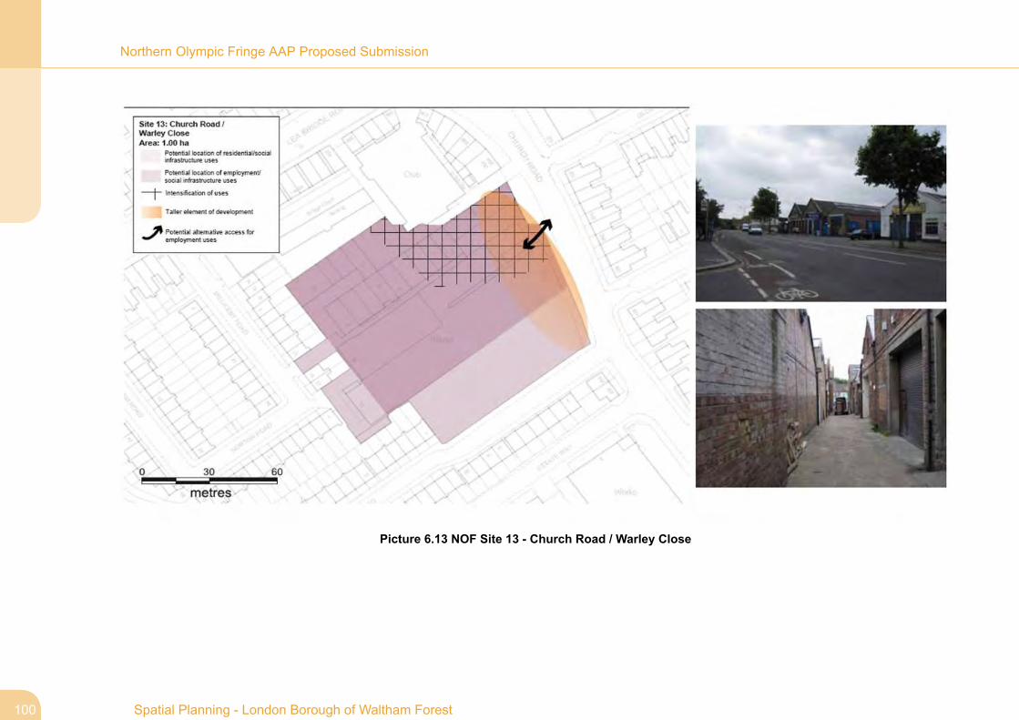
Policy NOF3: Site 13 - Church Road - Warley Close
Policy NOF2: Site 13 - Church Road - Warley Close
Mixed use / employment / residential / social infrastructure.(Site Area - 1 hectare)
1. Development should achieve and contribute to the following:
a. Primary access for employment uses may be relocated toChurch Road. Any internal routes should be wide enoughto enable required vehicle movement.
b. Residential and social infrastructure uses should be locatedto the south and east of the site, and employment useslocated throughout the rest of the site. The north of the siteis furthest away from existing residential neighbours andtherefore should be the location of any employmentintensification.
c. Redevelopment should seek to achieve active edges withdoors and windows opening onto the public realm.
d. Building heights of 2-3 storeys may be appropriate, howeverif designed sensitively 4 storeys may be achievable in somelocations. The height and amenity of 2 storey neighboursshould be respected.
6.66 Character area - Marsh Lane / Church Road
6.67 Current use - Industrial estate.
6.68 Context - The site lies in a predominantly residential area withsome retail and industrial uses. It edges Markhouse CornerNeighbourhood Centre in the north, Church Road in the east, andTallack Road and Millicent Road to the south and west. The neareststations are Queens Road and Leyton Midland which are both over15 minutes walking distance away.
6.69 PTAL - 1b - 3
6.70 Character area/site opportunities and challenges
Access – The main access to the industrial units is currentlyachieved fromMillicent Road, with secondary and limited accessfrom Church Road. Warley Close runs through the site and isnarrow restricting movement for vehicles. Millicent Road andTallack Road are typical residential streets and therefore notideal for access for industrial uses.
Existing buildings – The existing industrial units are 1-1.5 storeybrick buildings and are representative of interwar industrialarchitecture. They create a reasonably active frontage to ChurchRoad.
Vacant site – The south-eastern block, adjoining Tallack Road,is vacant.
99Spatial Planning - London Borough of Waltham Forest
Northern Olympic Fringe AAP Proposed Submission
Picture 6.13 NOF Site 13 - Church Road / Warley Close
Spatial Planning - London Borough of Waltham Forest100
Northern Olympic Fringe AAP Proposed Submission

Policy NOF3: Site 14 - Church Road - Estate Way
Policy NOF2: Site 14 - Church Road - Estate Way
Mixed use / employment / residential / social infrastructure.(Site Area - 5.23 hectares)
1. Development should achieve and contribute to the following:
a. Development should seek to achieve a better interface withthe playing fields. Buildings along this edge should bedesigned to be accessed from and overlook the spacebringing greater natural surveillance. Architecture shouldbe of a high quality.
b. Proposals should consider the provision of an attractivepedestrian and cycle path along the edge of DagenhamBrook and further consideration should be given to it crossingthe brook at a key location such as Lammas School.Development of the site should also seek to improve naturalsurveillance along existing routes, in particular Marsh Lane,providing a safer gateway to the open space.
c. The Brook is generally an underused asset which should berevitalised as a key green link and ecological spine with ahigh quality riverbank area.
d. A preliminary site evaluation would be required beforedevelopment proposals are considered.
6.71 Character area - Marsh Lane / Church Road
6.72 Current use - Industrial estate
6.73 Context - This busy industrial estate is in a number of differentownerships. It is edged by residential streets to the north and east,schools to the south and Seymour Road playing fields and LammasSchool to the west. Dagenham Brook runs along the western edgebetween the estate and the open space. The Lee Valley RegionalPark is approximately 10 minutes walking distance away and thenearest station is Leyton Midland which is over 15 minutes walkingdistance away.
6.74 PTAL - Broadly 2 with an area of 1b edging Marsh Lane.
6.75 Character area/site opportunities and challenges
Relationship to open space – The industrial estate backs ontoSeymour Road playing fields. It does not have windows or doorsopening onto the open space bringing little natural surveillance.This has created an edge to the open space that feels unsafe.
Access and street environment –Marsh Lane and the gatewayto Seymour Road playing fields have little activity. This is largelycreated by the inward looking nature of the industrial estate, buthas also been exacerbated by treatment at the edges of WillowBrook Primary and St Josephs Catholic Infant School. Theinterface with Church Road is also poor with limited naturalsurveillance and extensive open security fencing allowing viewsonto tatty looking buildings. The arrangement of the estate alsorestricts movement in an east-westerly direction creating a barrierbetween the residential streets to the east and the open spaceand Lammas School to the west. Access is also restricted byDagenham Brook. Scope for approximately upto 90 residentialunits.
Dagenham Brook - Dagenham Brook runs along the westernedge of the site and is polluted and overgrown. It creates abarrier to the open space, but Marsh Lane at the south of the site
101Spatial Planning - London Borough of Waltham Forest
Northern Olympic Fringe AAP Proposed Submission

bridges the river providing a pedestrian/cyclist connection to theopen space. The Brook is an undervalued asset between theopen space and the industrial estate.
Flood zone – The site edges flood zone 3/2a by DagenhamBrook.
APZ – Part of the site lies within APZ1.
Trees – There are a number of mature trees running along theedge of Dagenham Brook that merit retention.
Spatial Planning - London Borough of Waltham Forest102
Northern Olympic Fringe AAP Proposed Submission

Picture 6.14 NOF Site 14 - Church Road - Estate Way
103Spatial Planning - London Borough of Waltham Forest
Northern Olympic Fringe AAP Proposed Submission

Policy NOF3: Site 15 - Church Road - Etloe Road
Policy NOF2: Site 15 - Church Road - Etloe Road
Mixed use / employment / residential / social infrastructure.(Site Area - 2.13 hectares)
1. Development should achieve and contribute to the following:
a. Development of this site should seek to achieve a betterinterface with the playing fields. Buildings along this edgeshould be designed to be accessed from and overlook thespace bringing greater natural surveillance. Given theprominence of the site in relation to the adjacent open space,a high quality design will be required.
b. Development should seek to improve natural surveillancealong Ive Farm Lane.
c. The DagenhamBrookis generally an underused asset whichshould be revitalised as a key green link and ecological spinewith a high quality riverbank area.
d. Consideration should be given to the possible risk of flooding,particularly in relation to vulnerable uses such as housing.Where housing is proposed an Exception Test would berequired.
6.76 Character area - Marsh Lane / Church Road
6.77 Current use - Industrial estate
6.78 Context - This site is edged by Marsh Lane playing fields inthe west, St Joseph’s Infants School in the north and Etloe Road andIve Farm Lane to the east and south. At the southern most point of
the site, Ive Farm Lane crosses Dagenham Brook which runs betweenthe site and the playing fields. Markhouse Corner NeighbourhoodCentre is approximately 10 minutes walking distance away and thenearest train station is Leyton Midland which is over 15 minuteswalking distance away.
6.79 PTAL - 1b
6.80 Character area/site opportunities and challenges
Relationship to open space – The industrial estate backs ontoMarsh Lane playing fields. It does not have windows or doorsopening onto the open space bringing little natural surveillance.This has created an edge to the open space that feels unsafe.The site's existing interface with Etloe Road is of a domestic scaleso does not feel awkward within the residential environment.Scope for approximately upto 25 residential units.
Access and street environment – Ive Farm Lane suffers frominactive edges and the route feels very unsafe.
Dagenham Brook - Dagenham Brook runs along the westernedge of the site and is polluted and overgrown. The Brook is anundervalued asset between the open space and the industrialestate.
Flood zone – The site is within flood zone 3a/2.
Spatial Planning - London Borough of Waltham Forest104
Northern Olympic Fringe AAP Proposed Submission
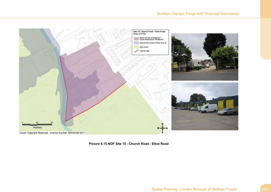
Picture 6.15 NOF Site 15 - Church Road - Etloe Road
105Spatial Planning - London Borough of Waltham Forest
Northern Olympic Fringe AAP Proposed Submission

Policy NOF5: Site 16 - Rigg Approach
Policy NOF2: Site 16 - Rigg Approach
Intensification / enhancement of employment generatingland uses. (Site Area - 5.12 hectares)
1. Development should achieve and contribute to the following:
a. The Lea Valley Pathway Corridor gateway (eastern cornerof the site) should be improved to create a focal point whichannounces and raises the profile of the regional park. Theopenness of the Lee Valley Regional Park should also besafeguarded and this site should be designed andmanagedto enhance its ecological potential. The Dagenham BrookCorridor is to the western edge of the site and the Councilmay seek contributions towards its enhancement.
b. Development should not have a detrimental effect on thenature conservation and wildlife value of the SSSI, and takeopportunities to enhance it. This may be through habitatcreation such as incorporating bird/ bat boxes or using swiftbricks; provision of green roofs/walls; or planting nectar richnative species.
c. The Council will seek to maintain the open character of thisland and therefore any proposed buildings should be limitedin scale and carefully sited.
d. Connection should bemade to the pedestrian bridge towardsthe north of the site and any development is likely to berequired to make contributions to improve the quality of theeast-western link from Argall Way to the Lea Valley PathwayCorridor.
e. Any development should seek to improve the quality of thefrontage adjacent to Lea Bridge Road. Developments mayalso be required to make contributions to broader publicrealm improvements along Lea Bridge Road.
f. The site is in a number of different ownerships, aco-ordinated approach to development will be required.
g. A preliminary site evaluation would be required beforedevelopment proposals are considered.
h. Development will need to take account of the level differenceat the south-eastern corner of the site and seek to achievean appropriate and inclusive connection with Lea BridgeRoad and the remainder of the site.
6.81 Character area - Lea Bridge
6.82 Current use - Industrial estate
6.83 Context - This triangular site lies within the Lee Valley RegionalPark. It is edged by the Stratford to Cheshunt/Stansted Airport railwayline to the north-east, Lea Bridge Road to the south-east, and theRiver Lea flood relief channel to the west. The flood relief channeland broader area are designated as a Site of Special Scientific Interest(SSSI). The nearest station is Clapton which is approximately 20minutes walking distance away and the nearest centre is MarkhouseCorner Neighbourhood Centre which is a little over 10 minutes walkingdistance away.
6.84 PTAL - 2/3
6.85 Character area/site opportunities and challenges
Spatial Planning - London Borough of Waltham Forest106
Northern Olympic Fringe AAP Proposed Submission
Lee Valley Regional Park – The eastern corner of the siteadjacent to Lea Bridge Road is identified in the Lee ValleyRegional Park Plan 2000 as a key entrance point to the LeaValley Pathway Corridor.
Site of Special Scientific Interest (SSSI) and MetropolitanOpen Land (MOL) – The site is immediately adjacent to theWalthamstow Marshes SSSI and the Lea Bridge MOL.Isolated site – The railway line and flood relief channel createa barrier to the site. The site is only accessible from Lea BridgeRoad in the south-east. There is a pedestrian footbridge to thenorth of the site that provides an east-west connection over therailway line, however it is inaccessible from Rigg Approach.
Low Public Transport Accessibility Level (PTAL)/redundantstation – The area currently suffers from a low PTAL, with theredundant Lea Bridge Station to the edge of the site. There areaspirations to reopen the redundant Lea Bridge Station. Shouldthe station be reopened, the developer will be required to improvepedestrian/cycle links to this station.Poor quality of public realm along Lea Bridge Road – Otherthan the Greyhound pub, the existing buildings and land useswithin the site create an inactive and unattractive edge to LeaBridge Road.
Site ownership - The site is in a number of different ownerships.Archaeological Priority Zone (APZ) – Part of the site lies withinAPZ1.
Level difference – There is approximately a 2 metre leveldifference between the south-eastern edge of the site and LeaBridge Road.
107Spatial Planning - London Borough of Waltham Forest
Northern Olympic Fringe AAP Proposed Submission

Picture 6.16 NOF Site 16 - Rigg Approach
Spatial Planning - London Borough of Waltham Forest108
Northern Olympic Fringe AAP Proposed Submission

Policy NOF3: Site 17 - Lea Bridge Gas Holders
Policy NOF2: Site 17 - Lea Bridge Gas Holders
Mixed use / employment / residential redevelopment in theevent of de-commissioning by National Grid. (Site Area - 2.49hectares)
1. Development should achieve and contribute to the following:
a. New proposals should seek to improve connections with thesurrounding area, particularly for cyclists and pedestrians.This may be achieved by creating a new link from OliverRoad.
b. Due to the nature of the surrounding area, any proposedresidential uses should be appropriately located to the northof the site and employment to the south. Employment usesmay be accessed from Oliver Road.
c. Any new development should respect the open nature ofLeyton Marshes, and any new buildings edging this spaceare to achieve high standards of design supported by highquality landscaping.
d. Mitigation measure should be provided in respect of possiblerisk of flooding, particularly in relation to uses such ashousing.
e. A contamination report should be provided and anymitigationmeasures should be taken prior to work commencing onsite.
f. A preliminary site evaluation would be required beforedevelopment proposals are considered.
6.86 Character area - Marsh Lane / Church Road
6.87 Current use - Gas-holders site
6.88 Context - This National Grid owned site is edged by SeymourRoad playing fields in the east, Golden Business Park to the west andWarner housing on Clementina Road to the north. The site is closeto the Lee Valley Regional Park, and the nearest stations are LeytonMidland and Clapton which are over 20 minutes walking distanceaway. Markhouse Corner Neighbourhood Centre is within 10 minuteswalking distance.
6.89 PTAL - Predominantly 2, with 1b in the south-eastern corner.
6.90 Character area/site opportunities and challenges
Access – The site is currently accessed from Clementina Roadwhich is a quiet Warner terraced street. The other edges of thesite create a barrier to movement.
Metropolitan Open Land (MOL) – The eastern edge of the siteis adjacent to Leyton Marshes Metropolitan Open Land.
Mature trees - There are a number of mature trees edgingSeymour Road playing fields that may merit retention.
Flood zone – The site is within flood zone 3a/2.
Contaminants – Given the site's current use, the site is likely tobe contaminated.
Archaeological Priority Zone (APZ)– The site lies within APZ1.
109Spatial Planning - London Borough of Waltham Forest
Northern Olympic Fringe AAP Proposed Submission

Picture 6.17 NOF Site 17 - Lea Bridge Gas Holders
Spatial Planning - London Borough of Waltham Forest110
Northern Olympic Fringe AAP Proposed Submission

Policy NOF5: Site 18 - Argall Avenue
Policy NOF2: Site 18 - Argall Avenue
Intensification of employment generating land uses. (SiteArea - 27.8 hectares)
1. Development should achieve and contribute to the following:
a. Access for the waste facility should be made from ArgallWay to reduce the volume of lorries and vans along StaffaRoad.
b. Any development at the south of the site edging Lea BridgeRoad should be of an appropriate scale and quality to actas a gateway to the borough.
c. Developers would be required to make contributions toimprove the quality of the streetscape on Lea Bridge Road.
d. Improvements should be made to both the north-south andeast-western routes within the site to make them feel safer.This may be achieved by activating their edges so they areoverlooked. Contributions are likely to be sought to improvethe east-western link beyond the boundaries of the site.
e. The open character of the Park should be retained andwhere necessary areas of industry should be screened.Signage should be provided to identify the location of thepark where required. New buildings edging the Park shouldoverlook the open space and be of a high quality design asthey will be highly visible.
f. Development will need to ensure it does not have adetrimental effect on the nature conservation and wildlifevalue of the SSSI, and take opportunities to enhance it.
This may be through habitat creation such as incorporatingbird/ bat boxes or using swift bricks; provision of greenroofs/walls; or planting nectar rich native species.
g. The green corridor should be retained and enhanced wherenecessary. The tree that is subject to a Preservation Orderand others that merit protection should be retained.
h. A preliminary site evaluation would be required beforedevelopment proposals are considered.
6.91 Character area - Lea Bridge
6.92 Current use - Industrial estate
6.93 Context - This large industrial site is edged by Low Hall Sportsground to the north-west, Low Hall Farm allotments and neighbouringresidential area to the east, and the Stratford to Cheshunt/StanstedAirport railway line in the west. Part of the site lies within the LeeValley Regional Park, is 10 –15 minutes walking distance fromMarkhouse Corner Neighbourhood Centre, and the nearest station isClapton which is approximately 20-25 minutes walking distance away.
6.94 PTAL - 1a/2
6.95 Character area/site opportunities and challenges
Public Transport Accessibility Level (PTAL) – The area suffersfrom a low PTAL rating, however the redundant Lea BridgeStation is immediately adjacent to the southern part of the site.There are aspirations to reopen the redundant Lea Bridge Stationas part of the Hall Farm Curve reinstatement. Should the stationbe reopened, the PTAL of the area is likely to increaseconsiderably.
111Spatial Planning - London Borough of Waltham Forest
Northern Olympic Fringe AAP Proposed Submission

Neighbouring uses – The site's industrial uses conflict withresidential neighbours towards the south of the site along StaffaRoad. In particular, the existing waste facility draws lorries andvans to the site which carry out awkward manoeuvres, and bringnoise and congestion to the street.
Borough gateway – The site edges a borough gateway at LeaBridge but it is of poor quality.Public realm – The quality of the public realm at Lea BridgeRoad is poor.
Pedestrian/cyclist links – The north-south link through the sitearound the bakery feels unsafe because it is not overlooked, islong, and is dog-legged preventing clear views along its entirelength. East-western links across the Stratford toCheshunt/Stansted Airport railway line are also poor. Thepedestrian footbridge adjacent to the bend in Argall Way providesa link to the Lee Valley Regional Park, but it is not overlookedand feels unsafe.
Lee Valley Regional Park – Part of the area is within the LeeValley Regional Park.
Site of Special Scientific Interest (SSSI) – The western edgeof the site is adjacent to Walthamstow Marshes SSSI.
Green corridors and existing trees – A green corridor runsalong the western and northern edges of the site which provideshabitats and a feeding station for wildlife. There is one treeadjacent to Staffa Road that is the subject of a PreservationOrder, and there are other large trees within the site that alsomerit retention.
Archaeological Priority Zone (APZ) – The site lies within APZ1.
Spatial Planning - London Borough of Waltham Forest112
Northern Olympic Fringe AAP Proposed Submission

Picture 6.18 NOF Site 18 - Argall Avenue
Policy NOF5: Site 19 - Low Hall Depot
Policy NOF2: Site 19 - Low Hall Depot
Potential redevelopment to includemixed use / employment/ social infrastructure / residential uses. (Site Area - 5.3hectares)
1. Development should achieve and contribute to the following:
a. The developer would be required to provide contributionsto improve the bus services in the area.
b. Proposed development should seek to provide active buildingfrontages thereby improving informal surveillance overadjacent streets.
113Spatial Planning - London Borough of Waltham Forest
Northern Olympic Fringe AAP Proposed Submission
c. Connections to Argall Avenue should be enhanced forpedestrians and cyclists.
d. Consideration should be given to enhancing DagenhamBrook as a key asset , at the same time taking into accountthe flood risk.
e. The unpleasant odours created by the tanks should be takeninto consideration when developing the site. These tanksshould be covered or relocated.
f. The flood zone may affect the nature of proposeddevelopment in areas of the site and an Exception Testwould be required.
g. A contamination report would be required beforedevelopment proposals are considered.
h. Development proposals should consider the possibleextension to Barn Croft school towards the north of the site.Should an associated secondary school be included as partof any proposals, designs should ensure the edges of theschool bring activity to adjacent roads.
i. Development proposals should consider creating access tothis space.
j. A preliminary site evaluation would be required beforedevelopment proposals are considered.
6.96 Character area - Lea Bridge
6.97 Current use - Council offices, depot and recycling.
6.98 Context - This site is located just outside the eastern edge ofthe Lee Valley Regional Park and is surrounded by park on most ofits edges. Argall Avenue industrial estate is immediately to the southof the site, Low Hall sports ground to the west, and Barn Croft schoolto the east with a broadly residential area beyond. The site isapproximately 10 minutes walking distance from Walthamstow MajorCentre and the nearest station is St James’ Street which is alsoapproximately 10 minutes walking distance away.
6.99 PTAL - The PTAL of the area varies from 2 in the north to 1bin the south.
6.100 Character area/site opportunities and challenges
Public Transport Accessibility Level (PTAL) – The PTAL ofthe area is low.
Inactive edges - Existing site is inward looking creating aninactive edge along South Access Road and other roads edgingthe site.
DagenhamBrook – Dagenham Brook runs through the site withmature trees along its edge.
Storm overflow tanks - Storm water overflow tanks on the siteprovide an overflow system for the foul and rain water fromWalthamstow. When the water drains from the tanks they createunpleasant odours, lowering the quality of the environment.
Flood zone – Parts of the site are within flood zone 2 and 3b.
Contamination – The site is likely to be contaminated.
Neighbouring school – Barn Croft school adjacent to the sitecould potentially extend into the site.
Spatial Planning - London Borough of Waltham Forest114
Northern Olympic Fringe AAP Proposed Submission

Flood storage area – The Environment Agency use an area tothe east of the site for flood storage, which is designated an areaof local nature conservation importance.
Archaeological Priority Zone (APZ) – The site lies within APZ1.
115Spatial Planning - London Borough of Waltham Forest
Northern Olympic Fringe AAP Proposed Submission

Picture 6.19 NOF Site 19 - Low Hall Depot
Spatial Planning - London Borough of Waltham Forest116
Northern Olympic Fringe AAP Proposed Submission

Policy NOF4: Site 20 - Lea Bridge Road - Thames Water
Policy NOF2: Site 20 - Lea Bridge Road - ThamesWater
Enhancement of open space and improved access toMetropolitan Open Land and Lee Valley Regional Park. (SiteArea - 6.14 hectares)
1. Development should achieve and contribute to the following:
a. Lea Bridge Road area should be enhanced to improve thequality of experience for pedestrians and cyclists. The edgesof the road should be activated with small scale activities(appropriate within a MOL) to improve natural surveillance.
b. The Thames Water Depot building should be retained andany maintenance or enhancement should be sympatheticto the original building. Any alterations or extensions will beexpected to achieve a high standard of design. Theremnants of tram lines and any other historic features shouldbe retained as they bring heritage interest to the area.
c. The Council will seek to maintain the open character of thisland and therefore any proposed buildings should be limitedin scale and carefully sited.
d. Development will need to ensure it does not have adetrimental effect on the nature conservation or wildlife valueof the SSSI.
6.101 Character area - Lea Valley
6.102 Current use - Light industrial use - within MOL designation.
6.103 Context - This site is within the Lee Valley Regional Parkand lies to the south of Lea Bridge Road opposite the Lee Valley IceCentre. The southern and western edges are defined by the RiverLea, and the Walthamstow Marshes Site of Special Scientific Interest(SSSI) lies to the east. Clapton is the nearest station which isapproximately 15 minutes walking distance away.
6.104 PTAL - 2
6.105 Character area/site opportunities and challenges
Public transport accessibility level (PTAL) – The PTAL of thearea is low. Should Lea Bridge Station be reopened, the PTALof the area will improve and give the site access to a station within5 minutes walking distance.
Borough gateway – This site is at one of the borough gatewayson the boundary with Hackney.
Lee Valley Regional Park – This site is within the Lee ValleyRegional Park. It is adjacent to Waterworks nature reserve andgolf centre, and the Lee Valley ice and riding centres are oppositeforming a recreational hub to the Park. The Lea Valley PathwayCorridor runs along the eastern edge of the site.
Public realm –The existing public realm on Lea Bridge Road isvehicle dominated with vehicles moving at speed. There is littlenatural surveillance provided by neighbouring buildings, creatingan environment that is unfriendly to cyclists and pedestrians.Unattractive and heavily engineered palisade railings to the edgeof the site further reduce environmental quality. The public realmat Lea Bridge Road area should be improved.
117Spatial Planning - London Borough of Waltham Forest
Northern Olympic Fringe AAP Proposed Submission

Local listing – The imposing Victorian Thames Water Depotbuilding is Locally Listed. Remnants of tram lines that were usedfor transporting coal to drive the water pump are still present.
MetropolitanOpen Land (MOL) – This site is part the Lea Bridge(South) MOL.
Site of Special Scientific Interest (SSSI) - The site is adjacentto part of the Walthamstow Marshes SSSI. This is currentlyfenced off as a bird sanctuary.
Spatial Planning - London Borough of Waltham Forest118
Northern Olympic Fringe AAP Proposed Submission

Picture 6.20 NOF Site 20 - Lea Bridge Road - Thames Water Site
119Spatial Planning - London Borough of Waltham Forest
Northern Olympic Fringe AAP Proposed Submission

Policy NOF4: Site 21 - Lea Valley Ice Rink
Policy NOF2: Site 21 - Lee Valley Ice Rink
Opportunity for enhancement to increase access and viewsinto the Lea Valley Park. (Site Area - 9.62 hectares)
1. Development should achieve and contribute to the following:
a. The openness of the Lee Valley Regional Park should besafeguarded and this site should be designed andmanagedto enhance its ecological potential whilst also responding tothe open character of the area. Any proposed buildingsshould not be higher than the existing ice rink building.
d. Consider providing horse trails as part of linkages- considerwider context. Remove banking to edge of path along floodrelief channel – create a route between the paddocks to thenorth of the site.
e. Development will need to ensure it does not have adetrimental effect on the nature conservation and wildlifevalue of the SSSI.
f. The Council will seek to maintain the open character of thisland and therefore any proposed buildings should be limitedin scale and carefully sited.
g. Lea Bridge Road area should be enhanced to improve thequality of experience for pedestrians and cyclists andpromote this location important recreational facility withinthe Lea Valley Park.
h. A preliminary site evaluation would be required beforedevelopment proposals are considered.
6.106 Character area - Lea Valley
6.107 Current use - Ice rink and riding stables, with car-park.
6.108 Context - This site lies near the borough boundary withHackney and is within the Lee Valley Regional Park. The southernedge is defined by Lea Bridge Road and the east by the River LeaFlood Relief Channel which is also part of the Walthamstow MarshesSite of Special Scientific Interest (SSSI). The SSSI continues acrossthe north of the site and the western edge of the site is defined by theLea Valley Pathway Corridor.
6.109 PTAL - 2
6.110 Character area/site opportunities and challenges
Lee Valley Regional Park – The area is within the Lee ValleyRegional Park.Views – Views of buildings in Hackney to the west affect theopen nature of the site. Some views to the west of the industrialestates are poor quality. Views from Lea Bridge Road towardsthe Lee Valley Regional Park are limited and could be enhanced.
Public transport accessibility level (PTAL) – The general areasuffers from a low PTAL. Should Lea Bridge Station be reopened,the PTAL of the area will improve and provide access to a stationwithin 5 minutes walking distance of the site.
Linkages – The existing link from the north of the site across therailway line and flood relief channel to Argall Way feels extremelyunsafe. The riding school extension creates a barrier to east-westmovement. The route along the edge of the flood relief channelis banked restricting views to the riding stable and open spaceand which reduce natural surveillance to and from the path.
Site of Special Scientific Interest (SSSI) – The site isimmediately adjacent to the Walthamstow Marshes SSSI.
Spatial Planning - London Borough of Waltham Forest120
Northern Olympic Fringe AAP Proposed Submission

Metropolitan Open Land (MOL) – This site is part of the LeaBridge South MOL.
Car park – The existing car park is underused.
Public realm – The public realm at Lea Bridge Road is dominatedby vehicles, is not of a pedestrian scale and should be improvedparticularly for pedestrians and cyclists.
Flood zone – The site lies within flood zone 2.
Archaeological Priority Zone (APZ) – The site lies with APZ1.
121Spatial Planning - London Borough of Waltham Forest
Northern Olympic Fringe AAP Proposed Submission

Picture 6.21 NOF Site 21 - Lea Valley Ice Rink
Spatial Planning - London Borough of Waltham Forest122
Northern Olympic Fringe AAP Proposed Submission

Policy NOF4: Site 22 - Essex Wharf
Policy NOF2: Site 22 - Essex Wharf
Residential. (Site Area - 0.66 hectares)
1. Development should achieve and contribute to the following:
a. The openness of the Lee Valley Regional Park should besafeguarded and this site should be designed andmanagedto enhance its ecological potential whilst also responding tothe open character of the area.
b. Development will need to ensure it does not have adetrimental effect on the nature conservation interests ofthe Site of Special Scientific Interest (SSSI).
c. This is a prominent and highly visible site into the borough,a high quality of design will be required.
d. A preliminary site evaluation would be required beforedevelopment proposals are considered since it is within theArchaeological Priority Zone (APZ).
6.111 Character area - Lea Valley
6.112 Current use - Disused industrial site.
6.113 Context - This site lies on the borough boundary with Hackneyand is within the Lee Valley Regional Park. It is in a prominent locationon a bend of the River Lea with North Millfields recreation ground onthe opposite side of the river. The Lee Valley Ice Centre is behind
the site to the east, with the site currently accessed from Lea BridgeRoad. The nearest station is Clapton which is approximately 10minutes walking distance away.
6.114 PTAL - 2
6.115 Character area/site opportunities and challenges
Lee Valley Regional Park – This site lies within the Lee ValleyRegional Park on the edge of the River Lea which is defined asa green corridor in Hackney’s Core Strategy.
Site of Special Scientific Interest (SSSI) and MetropolitanOpen Land (MOL) – The site is immediately adjacent to theWalthamstow Marshes SSSI and the LeaBridge (south) MOL.
Archaeological Priority Zone (APZ) –The site lies within APZ1.
Flood zone – This site is within flood zone 2.
Gateway – This is a prominent gateway site into the borough.Scope for approximately 124 residential units.
123Spatial Planning - London Borough of Waltham Forest
Northern Olympic Fringe AAP Proposed Submission

Picture 6.22 NOF Site 22 - Essex Wharf
Spatial Planning - London Borough of Waltham Forest124
Northern Olympic Fringe AAP Proposed Submission

Policy NOF5: Site 23 - 97 Lea Bridge Road
Policy NOF2: Site 23 - 97 Lea Bridge Road
Mixed use / employment / residential / social infrastructure.(Site Area - 0.82 hectares)
1. Development should achieve and contribute to the following:
a. Access for the waste facility may be made from Argall Wayto reduce the volume of lorries and vans along Staffa Road.
b. Building heights of 3-4 storeys would be considered andthey should be designed to bring activity and naturalsurveillance to Wellington and Burwell Road. This may beachieved by providing a number of doors and widows openonto the public realm.
c. A preliminary site evaluation would be required beforedevelopment proposals are considered.
6.116 Character area - Lea Bridge
6.117 Current use - Light industry
6.118 Context - This prominent site lies to the south eastern edgeof the Argall Avenue industrial estate along Wellington Road. Thearea to the north and east is predominantly residential in characterand is a short distance away from Lea Bridge Road. The neareststations are St James’ Street and Clapton and are both approximately20minutes walking distance away. Markhouse Corner NeighbourhoodCentre is approximately 10 minutes walking distance away.
6.119 PTAL - 2
6.120 Character area/site opportunities and challenges
Public transport accessibility level (PTAL) – The area suffersfrom a low PTAL, however the redundant Lea Bridge Station isa short distance away from the site. There are aspirations toreopen the redundant Lea Bridge Station. Should the station bereopened, the PTAL of the area is likely to increase considerably.Neighbouring uses – The industrial uses on Argall WayIndustrial Estate (particularly the waste facility on Staffa Road)bring lorries and vans along Wellington Road and Staffa Road.These vehicles carry out awkward manoeuvres and bring noiseand congestion to the streets.
Archaeological Priority Zone (APZ) – The site lies within APZ1.
125Spatial Planning - London Borough of Waltham Forest
Northern Olympic Fringe AAP Proposed Submission
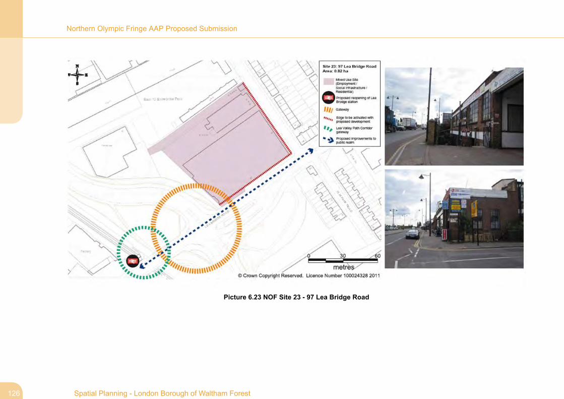
Picture 6.23 NOF Site 23 - 97 Lea Bridge Road
Spatial Planning - London Borough of Waltham Forest126
Northern Olympic Fringe AAP Proposed Submission