Embed Size (px)
Citation preview
Project:Project Number:
Project Manager:Reported:
EEI - Carlsbad2195 Faraday Ave., Ste K ACR-71294
Brian Brennan
Bialkowski
01/16/12 13:27Carlsbad CA, 92008
25712 Commercentre DriveLake Forest, California 92630
949.297.5020 Phone949.297.5027 Fax
Notes and Definitions
Sample results reported on a dry weight basis
Relative Percent DifferenceRPD
dry
Not ReportedNR
Analyte NOT DETECTED at or above the reporting limitND
Analyte DETECTEDDET
Daniel Chavez, Project Manager
SunStar Laboratories, Inc. The results in this report apply to the samples analyzed in accordance with the chain of custody document. This analytical report must be reproduced in its entirety.
Page 55 of 55
Phase I ESA and Limited Phase II Sampling March 19, 2012 (March 26, 2012 revisions) Accretive Investments, Inc., “Bialkowski” Property – Escondido, CA EEI Project No. ACR-71294
APPENDIX H LIMITED AST SUBSURFACE SAMPLING
LABORATORY REPORT AND CHAIN OF CUSTODY
25712 Commercentre DriveLake Forest, California 92630
949.297.5020 Phone949.297.5027 Fax
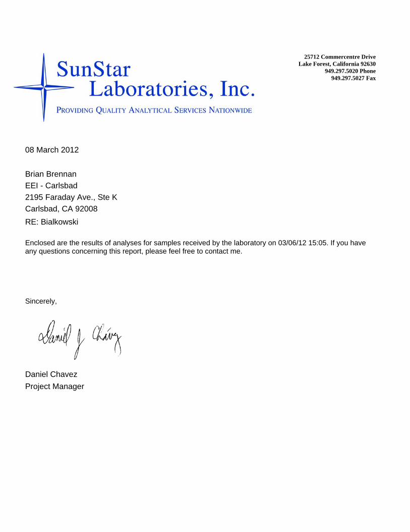
EEI - Carlsbad
RE: BialkowskiCarlsbad, CA 920082195 Faraday Ave., Ste K
Brian Brennan
Daniel ChavezProject Manager
Enclosed are the results of analyses for samples received by the laboratory on 03/06/12 15:05. If you have any questions concerning this report, please feel free to contact me.
Sincerely,
08 March 2012
Project:Project Number:
Project Manager:Reported:
EEI - Carlsbad2195 Faraday Ave., Ste K ACR-71294
Brian Brennan
Bialkowski
03/08/12 10:38Carlsbad CA, 92008
25712 Commercentre DriveLake Forest, California 92630
949.297.5020 Phone949.297.5027 Fax
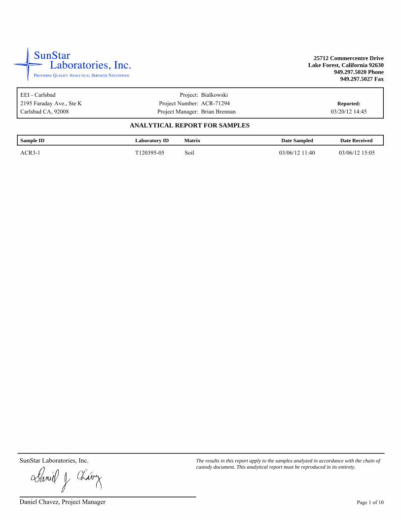
Sample ID Laboratory ID Matrix Date Sampled
ANALYTICAL REPORT FOR SAMPLES
Date Received
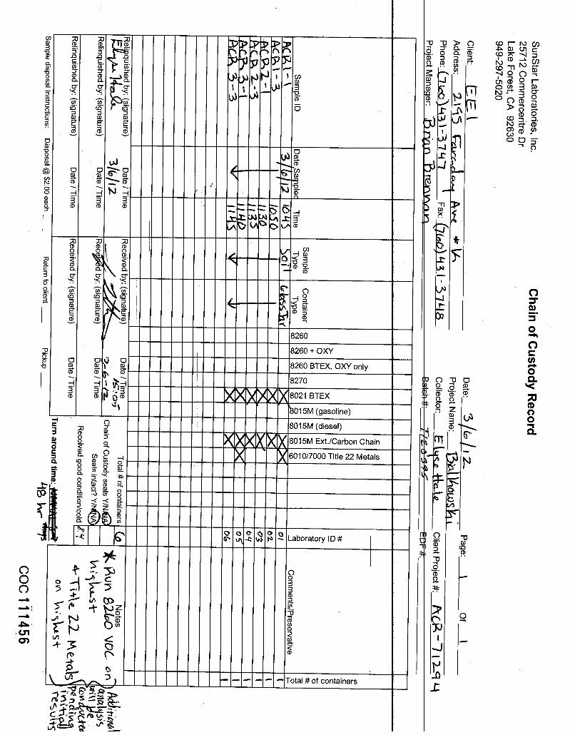
ACR1-1 T120395-01 Soil 03/06/12 10:45 03/06/12 15:05
ACR1-3 T120395-02 Soil 03/06/12 10:50 03/06/12 15:05
ACR2-1 T120395-03 Soil 03/06/12 11:30 03/06/12 15:05
ACR2-3 T120395-04 Soil 03/06/12 11:35 03/06/12 15:05
ACR3-1 T120395-05 Soil 03/06/12 11:40 03/06/12 15:05
ACR3-3 T120395-06 Soil 03/06/12 11:45 03/06/12 15:05
Daniel Chavez, Project Manager
SunStar Laboratories, Inc. The results in this report apply to the samples analyzed in accordance with the chain of custody document. This analytical report must be reproduced in its entirety.
Page 1 of 9

Project:Project Number:
Project Manager:Reported:
EEI - Carlsbad2195 Faraday Ave., Ste K ACR-71294
Brian Brennan
Bialkowski
03/08/12 10:38Carlsbad CA, 92008
25712 Commercentre DriveLake Forest, California 92630
949.297.5020 Phone949.297.5027 Fax
ResultAnalyte Limit BatchReporting
Prepared Analyzed Method Notes DilutionUnits
ACR1-1T120395-01 (Soil)
SunStar Laboratories, Inc.
Extractable Petroleum Hydrocarbons by 8015CND EPA 8015C03/07/12 03/07/12 mg/kg 20307071C6-C12 (GRO) 10ND "" "" ""C13-C28 (DRO) 10ND "" "" ""C29-C40 (MORO) 10
"" " "65-13584.2 %Surrogate: p-Terphenyl
Daniel Chavez, Project Manager
SunStar Laboratories, Inc. The results in this report apply to the samples analyzed in accordance with the chain of custody document. This analytical report must be reproduced in its entirety.
Page 2 of 9

Project:Project Number:
Project Manager:Reported:
EEI - Carlsbad2195 Faraday Ave., Ste K ACR-71294
Brian Brennan
Bialkowski
03/08/12 10:38Carlsbad CA, 92008
25712 Commercentre DriveLake Forest, California 92630
949.297.5020 Phone949.297.5027 Fax
ResultAnalyte Limit BatchReporting
Prepared Analyzed Method Notes DilutionUnits
ACR1-3T120395-02 (Soil)
SunStar Laboratories, Inc.
Extractable Petroleum Hydrocarbons by 8015CND EPA 8015C03/07/12 03/07/12 mg/kg 20307071C6-C12 (GRO) 10ND "" "" ""C13-C28 (DRO) 10ND "" "" ""C29-C40 (MORO) 10
"" " "65-13585.9 %Surrogate: p-Terphenyl
Daniel Chavez, Project Manager
SunStar Laboratories, Inc. The results in this report apply to the samples analyzed in accordance with the chain of custody document. This analytical report must be reproduced in its entirety.
Page 3 of 9
Project:Project Number:
Project Manager:Reported:
EEI - Carlsbad2195 Faraday Ave., Ste K ACR-71294
Brian Brennan
Bialkowski
03/08/12 10:38Carlsbad CA, 92008
25712 Commercentre DriveLake Forest, California 92630
949.297.5020 Phone949.297.5027 Fax
ResultAnalyte Limit BatchReporting
Prepared Analyzed Method Notes DilutionUnits
ACR2-1T120395-03 (Soil)
SunStar Laboratories, Inc.
Extractable Petroleum Hydrocarbons by 8015CND EPA 8015C03/07/12 03/07/12 mg/kg 20307071C6-C12 (GRO) 10ND "" "" ""C13-C28 (DRO) 10ND "" "" ""C29-C40 (MORO) 10
"" " "65-13588.5 %Surrogate: p-Terphenyl
Daniel Chavez, Project Manager
SunStar Laboratories, Inc. The results in this report apply to the samples analyzed in accordance with the chain of custody document. This analytical report must be reproduced in its entirety.
Page 4 of 9

Project:Project Number:
Project Manager:Reported:
EEI - Carlsbad2195 Faraday Ave., Ste K ACR-71294
Brian Brennan
Bialkowski
03/08/12 10:38Carlsbad CA, 92008
25712 Commercentre DriveLake Forest, California 92630
949.297.5020 Phone949.297.5027 Fax
ResultAnalyte Limit BatchReporting
Prepared Analyzed Method Notes DilutionUnits
ACR2-3T120395-04 (Soil)
SunStar Laboratories, Inc.
Extractable Petroleum Hydrocarbons by 8015CND EPA 8015C03/07/12 03/07/12 mg/kg 20307071C6-C12 (GRO) 10ND "" "" ""C13-C28 (DRO) 10ND "" "" ""C29-C40 (MORO) 10
"" " "65-13587.1 %Surrogate: p-Terphenyl
Daniel Chavez, Project Manager
SunStar Laboratories, Inc. The results in this report apply to the samples analyzed in accordance with the chain of custody document. This analytical report must be reproduced in its entirety.
Page 5 of 9

Project:Project Number:
Project Manager:Reported:
EEI - Carlsbad2195 Faraday Ave., Ste K ACR-71294
Brian Brennan
Bialkowski
03/08/12 10:38Carlsbad CA, 92008
25712 Commercentre DriveLake Forest, California 92630
949.297.5020 Phone949.297.5027 Fax
ResultAnalyte Limit BatchReporting
Prepared Analyzed Method Notes DilutionUnits
ACR3-1T120395-05 (Soil)
SunStar Laboratories, Inc.
Extractable Petroleum Hydrocarbons by 8015CND EPA 8015C03/07/12 03/07/12 mg/kg 20307071C6-C12 (GRO) 10
"480 " " "" "C13-C28 (DRO) 10"38 " " "" "C29-C40 (MORO) 10"" " "65-13586.2 %Surrogate: p-Terphenyl
Daniel Chavez, Project Manager
SunStar Laboratories, Inc. The results in this report apply to the samples analyzed in accordance with the chain of custody document. This analytical report must be reproduced in its entirety.
Page 6 of 9

Project:Project Number:
Project Manager:Reported:
EEI - Carlsbad2195 Faraday Ave., Ste K ACR-71294
Brian Brennan
Bialkowski
03/08/12 10:38Carlsbad CA, 92008
25712 Commercentre DriveLake Forest, California 92630
949.297.5020 Phone949.297.5027 Fax
ResultAnalyte Limit BatchReporting
Prepared Analyzed Method Notes DilutionUnits
ACR3-3T120395-06 (Soil)
SunStar Laboratories, Inc.
Extractable Petroleum Hydrocarbons by 8015CND EPA 8015C03/07/12 03/07/12 mg/kg 20307071C6-C12 (GRO) 10ND "" "" ""C13-C28 (DRO) 10ND "" "" ""C29-C40 (MORO) 10
"" " "65-13585.9 %Surrogate: p-Terphenyl
Daniel Chavez, Project Manager
SunStar Laboratories, Inc. The results in this report apply to the samples analyzed in accordance with the chain of custody document. This analytical report must be reproduced in its entirety.
Page 7 of 9
Project:Project Number:
Project Manager:Reported:
EEI - Carlsbad2195 Faraday Ave., Ste K ACR-71294
Brian Brennan
Bialkowski
03/08/12 10:38Carlsbad CA, 92008
25712 Commercentre DriveLake Forest, California 92630
949.297.5020 Phone949.297.5027 Fax
Result LimitReporting
Units LevelSpike
ResultSource
%REC%RECLimits RPD
RPDLimit Notes Analyte
Extractable Petroleum Hydrocarbons by 8015C - Quality ControlSunStar Laboratories, Inc.
Batch 2030707 - EPA 3550B GC
Blank (2030707-BLK1) Prepared & Analyzed: 03/07/12 C6-C12 (GRO) mg/kgND 10C13-C28 (DRO) "ND 10C29-C40 (MORO) "ND 10
" 100 65-135Surrogate: p-Terphenyl 78.078.0
LCS (2030707-BS1) Prepared & Analyzed: 03/07/12 C13-C28 (DRO) mg/kg530 10 500 75-125106
" 100 65-135Surrogate: p-Terphenyl 84.084.0
LCS Dup (2030707-BSD1) Prepared & Analyzed: 03/07/12 C13-C28 (DRO) mg/kg550 10 500 2075-125110 3.82
" 100 65-135Surrogate: p-Terphenyl 85.885.8
Daniel Chavez, Project Manager
SunStar Laboratories, Inc. The results in this report apply to the samples analyzed in accordance with the chain of custody document. This analytical report must be reproduced in its entirety.
Page 8 of 9
Project:Project Number:
Project Manager:Reported:
EEI - Carlsbad2195 Faraday Ave., Ste K ACR-71294
Brian Brennan
Bialkowski
03/08/12 10:38Carlsbad CA, 92008
25712 Commercentre DriveLake Forest, California 92630
949.297.5020 Phone949.297.5027 Fax
Notes and Definitions
Sample results reported on a dry weight basis
Relative Percent DifferenceRPD
dry
Not ReportedNR
Analyte NOT DETECTED at or above the reporting limitND
Analyte DETECTEDDET
Daniel Chavez, Project Manager
SunStar Laboratories, Inc. The results in this report apply to the samples analyzed in accordance with the chain of custody document. This analytical report must be reproduced in its entirety.
Page 9 of 9


25712 Commercentre DriveLake Forest, California 92630
949.297.5020 Phone949.297.5027 Fax
EEI - Carlsbad
RE: BialkowskiCarlsbad, CA 920082195 Faraday Ave., Ste K
Brian Brennan
Daniel ChavezProject Manager
Enclosed are the results of analyses for samples received by the laboratory on 03/06/12 15:05. If you have any questions concerning this report, please feel free to contact me.
Sincerely,
20 March 2012
Project:Project Number:
Project Manager:Reported:
EEI - Carlsbad2195 Faraday Ave., Ste K ACR-71294
Brian Brennan
Bialkowski
03/20/12 14:45Carlsbad CA, 92008
25712 Commercentre DriveLake Forest, California 92630
949.297.5020 Phone949.297.5027 Fax
Sample ID Laboratory ID Matrix Date Sampled
ANALYTICAL REPORT FOR SAMPLES
Date Received
ACR3-1 T120395-05 Soil 03/06/12 11:40 03/06/12 15:05
Daniel Chavez, Project Manager
SunStar Laboratories, Inc. The results in this report apply to the samples analyzed in accordance with the chain of custody document. This analytical report must be reproduced in its entirety.
Page 1 of 10
Project:Project Number:
Project Manager:Reported:
EEI - Carlsbad2195 Faraday Ave., Ste K ACR-71294
Brian Brennan
Bialkowski
03/20/12 14:45Carlsbad CA, 92008
25712 Commercentre DriveLake Forest, California 92630
949.297.5020 Phone949.297.5027 Fax
ResultAnalyte Limit BatchReporting
Prepared Analyzed Method Notes DilutionUnits
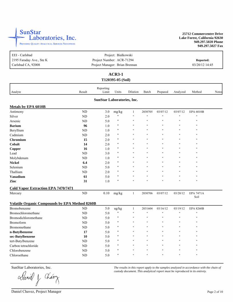
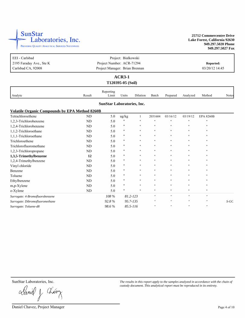
ACR3-1T120395-05 (Soil)
SunStar Laboratories, Inc.
Metals by EPA 6010BND EPA 6010B03/07/12 03/07/12 mg/kg 20307051Antimony 3.0ND "" "" ""Silver 2.0ND "" "" ""Arsenic 5.0
"96 " " "" "Barium 1.0ND "" "" ""Beryllium 1.0ND "" "" ""Cadmium 2.0
"15 " " "" "Chromium 2.0"14 " " "" "Cobalt 2.0"16 " " "" "Copper 1.0
ND "" "" ""Lead 3.0ND "" "" ""Molybdenum 1.0
"6.4 " " "" "Nickel 2.0ND "" "" ""Selenium 5.0ND "" "" ""Thallium 2.0
"61 " " "" "Vanadium 5.0"31 " " "" "Zinc 1.0
Cold Vapor Extraction EPA 7470/7471ND EPA 7471A
Soil03/07/12 03/20/12 mg/kg 20307061Mercury 0.10
Volatile Organic Compounds by EPA Method 8260BND EPA 8260B03/16/12 03/19/12 ug/kg 20316041Bromobenzene 5.0ND "" "" ""Bromochloromethane 5.0ND "" "" ""Bromodichloromethane 5.0ND "" "" ""Bromoform 5.0ND "" "" ""Bromomethane 5.0
"17 " " "" "n-Butylbenzene 5.0"10 " " "" "sec-Butylbenzene 5.0
ND "" "" ""tert-Butylbenzene 5.0ND "" "" ""Carbon tetrachloride 5.0ND "" "" ""Chlorobenzene 5.0ND "" "" ""Chloroethane 5.0
Daniel Chavez, Project Manager
SunStar Laboratories, Inc. The results in this report apply to the samples analyzed in accordance with the chain of custody document. This analytical report must be reproduced in its entirety.
Page 2 of 10
Project:Project Number:
Project Manager:Reported:
EEI - Carlsbad2195 Faraday Ave., Ste K ACR-71294
Brian Brennan
Bialkowski
03/20/12 14:45Carlsbad CA, 92008
25712 Commercentre DriveLake Forest, California 92630
949.297.5020 Phone949.297.5027 Fax
ResultAnalyte Limit BatchReporting
Prepared Analyzed Method Notes DilutionUnits
ACR3-1T120395-05 (Soil)
SunStar Laboratories, Inc.
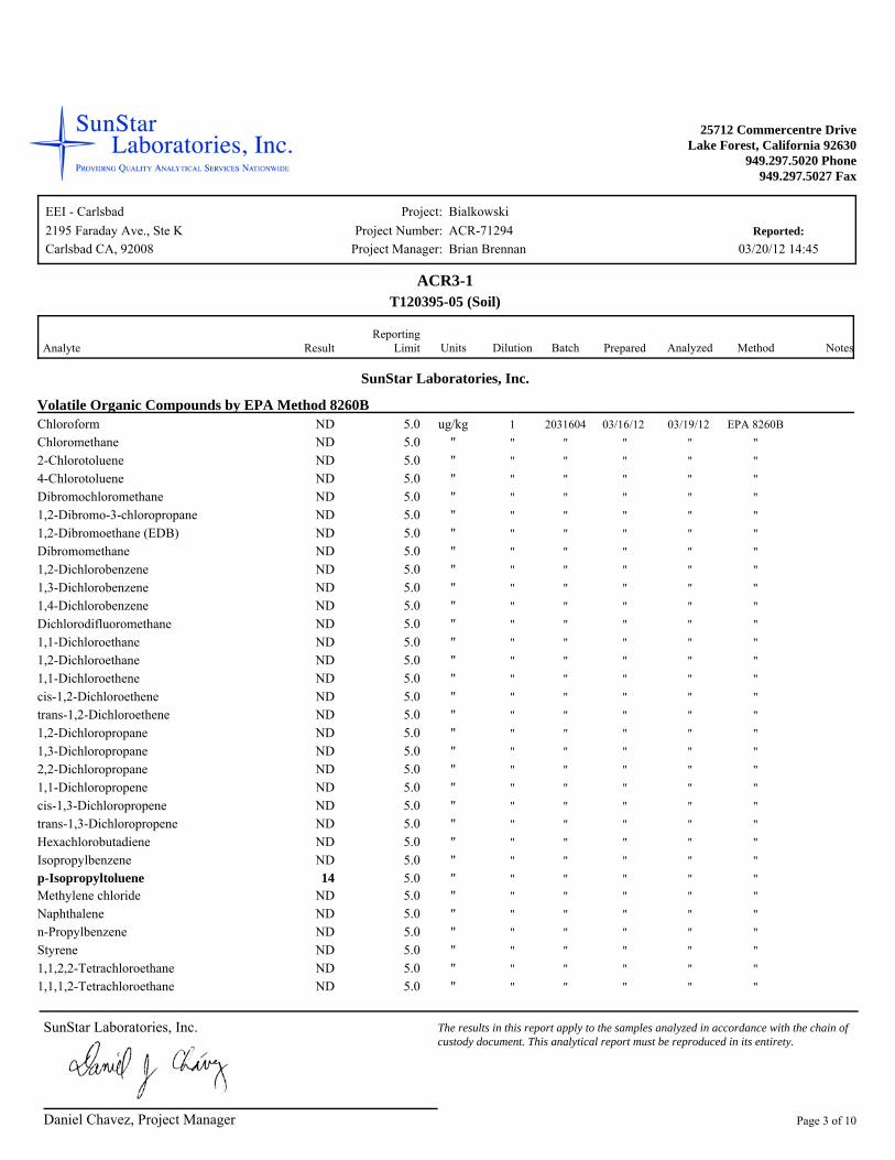
Volatile Organic Compounds by EPA Method 8260BND EPA 8260B03/16/12 03/19/12 ug/kg 20316041Chloroform 5.0ND "" "" ""Chloromethane 5.0ND "" "" ""2-Chlorotoluene 5.0ND "" "" ""4-Chlorotoluene 5.0ND "" "" ""Dibromochloromethane 5.0ND "" "" ""1,2-Dibromo-3-chloropropane 5.0ND "" "" ""1,2-Dibromoethane (EDB) 5.0ND "" "" ""Dibromomethane 5.0ND "" "" ""1,2-Dichlorobenzene 5.0ND "" "" ""1,3-Dichlorobenzene 5.0ND "" "" ""1,4-Dichlorobenzene 5.0ND "" "" ""Dichlorodifluoromethane 5.0ND "" "" ""1,1-Dichloroethane 5.0ND "" "" ""1,2-Dichloroethane 5.0ND "" "" ""1,1-Dichloroethene 5.0ND "" "" ""cis-1,2-Dichloroethene 5.0ND "" "" ""trans-1,2-Dichloroethene 5.0ND "" "" ""1,2-Dichloropropane 5.0ND "" "" ""1,3-Dichloropropane 5.0ND "" "" ""2,2-Dichloropropane 5.0ND "" "" ""1,1-Dichloropropene 5.0ND "" "" ""cis-1,3-Dichloropropene 5.0ND "" "" ""trans-1,3-Dichloropropene 5.0ND "" "" ""Hexachlorobutadiene 5.0ND "" "" ""Isopropylbenzene 5.0
"14 " " "" "p-Isopropyltoluene 5.0ND "" "" ""Methylene chloride 5.0ND "" "" ""Naphthalene 5.0ND "" "" ""n-Propylbenzene 5.0ND "" "" ""Styrene 5.0ND "" "" ""1,1,2,2-Tetrachloroethane 5.0ND "" "" ""1,1,1,2-Tetrachloroethane 5.0
Daniel Chavez, Project Manager
SunStar Laboratories, Inc. The results in this report apply to the samples analyzed in accordance with the chain of custody document. This analytical report must be reproduced in its entirety.
Page 3 of 10
Project:Project Number:
Project Manager:Reported:
EEI - Carlsbad2195 Faraday Ave., Ste K ACR-71294
Brian Brennan
Bialkowski
03/20/12 14:45Carlsbad CA, 92008
25712 Commercentre DriveLake Forest, California 92630
949.297.5020 Phone949.297.5027 Fax
ResultAnalyte Limit BatchReporting
Prepared Analyzed Method Notes DilutionUnits
ACR3-1T120395-05 (Soil)
SunStar Laboratories, Inc.
Volatile Organic Compounds by EPA Method 8260BND EPA 8260B03/16/12 03/19/12 ug/kg 20316041Tetrachloroethene 5.0ND "" "" ""1,2,3-Trichlorobenzene 5.0ND "" "" ""1,2,4-Trichlorobenzene 5.0ND "" "" ""1,1,2-Trichloroethane 5.0ND "" "" ""1,1,1-Trichloroethane 5.0ND "" "" ""Trichloroethene 5.0ND "" "" ""Trichlorofluoromethane 5.0ND "" "" ""1,2,3-Trichloropropane 5.0
"12 " " "" "1,3,5-Trimethylbenzene 5.0ND "" "" ""1,2,4-Trimethylbenzene 5.0ND "" "" ""Vinyl chloride 5.0ND "" "" ""Benzene 5.0ND "" "" ""Toluene 5.0ND "" "" ""Ethylbenzene 5.0ND "" "" ""m,p-Xylene 5.0ND "" "" ""o-Xylene 5.0
"" " "81.2-123108 %Surrogate: 4-Bromofluorobenzene"" " " S-GC95.7-13592.8 %Surrogate: Dibromofluoromethane"" " "85.5-11698.6 %Surrogate: Toluene-d8
Daniel Chavez, Project Manager
SunStar Laboratories, Inc. The results in this report apply to the samples analyzed in accordance with the chain of custody document. This analytical report must be reproduced in its entirety.
Page 4 of 10

Project:Project Number:
Project Manager:Reported:
EEI - Carlsbad2195 Faraday Ave., Ste K ACR-71294
Brian Brennan
Bialkowski
03/20/12 14:45Carlsbad CA, 92008
25712 Commercentre DriveLake Forest, California 92630
949.297.5020 Phone949.297.5027 Fax
Result LimitReporting
Units LevelSpike
ResultSource
%REC%RECLimits RPD
RPDLimit Notes Analyte
Metals by EPA 6010B - Quality ControlSunStar Laboratories, Inc.
Batch 2030705 - EPA 3051
Blank (2030705-BLK1) Prepared & Analyzed: 03/07/12 Antimony mg/kgND 3.0Silver "ND 2.0Arsenic "ND 5.0Barium "ND 1.0Beryllium "ND 1.0Cadmium "ND 2.0Chromium "ND 2.0Cobalt "ND 2.0Copper "ND 1.0Lead "ND 3.0Molybdenum "ND 1.0Nickel "ND 2.0Selenium "ND 5.0Thallium "ND 2.0Vanadium "ND 5.0Zinc "ND 1.0
LCS (2030705-BS1) Prepared & Analyzed: 03/07/12 Arsenic mg/kg102 5.0 100 75-125102Barium "95.5 1.0 100 75-12595.5Cadmium "96.7 2.0 100 75-12596.7Chromium "99.3 2.0 100 75-12599.3Lead "103 3.0 100 75-125103
LCS Dup (2030705-BSD1) Prepared & Analyzed: 03/07/12 Arsenic mg/kg89.3 5.0 100 2075-12589.3 13.6Barium "83.4 1.0 100 2075-12583.4 13.5Cadmium "85.2 2.0 100 2075-12585.2 12.6Chromium "87.1 2.0 100 2075-12587.1 13.1Lead "89.5 3.0 100 2075-12589.5 13.7
Daniel Chavez, Project Manager
SunStar Laboratories, Inc. The results in this report apply to the samples analyzed in accordance with the chain of custody document. This analytical report must be reproduced in its entirety.
Page 5 of 10
Project:Project Number:
Project Manager:Reported:
EEI - Carlsbad2195 Faraday Ave., Ste K ACR-71294
Brian Brennan
Bialkowski
03/20/12 14:45Carlsbad CA, 92008
25712 Commercentre DriveLake Forest, California 92630
949.297.5020 Phone949.297.5027 Fax
Result LimitReporting
Units LevelSpike
ResultSource
%REC%RECLimits RPD
RPDLimit Notes Analyte
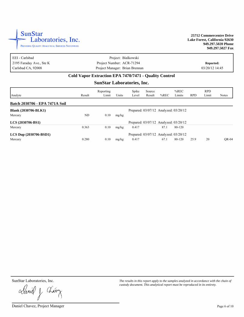
Cold Vapor Extraction EPA 7470/7471 - Quality ControlSunStar Laboratories, Inc.
Batch 2030706 - EPA 7471A Soil
Blank (2030706-BLK1) Prepared: 03/07/12 Analyzed: 03/20/12 Mercury mg/kgND 0.10
LCS (2030706-BS1) Prepared: 03/07/12 Analyzed: 03/20/12 Mercury mg/kg0.363 0.10 0.417 80-12087.1
LCS Dup (2030706-BSD1) Prepared: 03/07/12 Analyzed: 03/20/12 Mercury mg/kg0.280 0.10 0.417 20 QR-0480-12067.1 25.9
Daniel Chavez, Project Manager
SunStar Laboratories, Inc. The results in this report apply to the samples analyzed in accordance with the chain of custody document. This analytical report must be reproduced in its entirety.
Page 6 of 10
Project:Project Number:
Project Manager:Reported:
EEI - Carlsbad2195 Faraday Ave., Ste K ACR-71294
Brian Brennan
Bialkowski
03/20/12 14:45Carlsbad CA, 92008
25712 Commercentre DriveLake Forest, California 92630
949.297.5020 Phone949.297.5027 Fax
Result LimitReporting
Units LevelSpike
ResultSource
%REC%RECLimits RPD
RPDLimit Notes Analyte
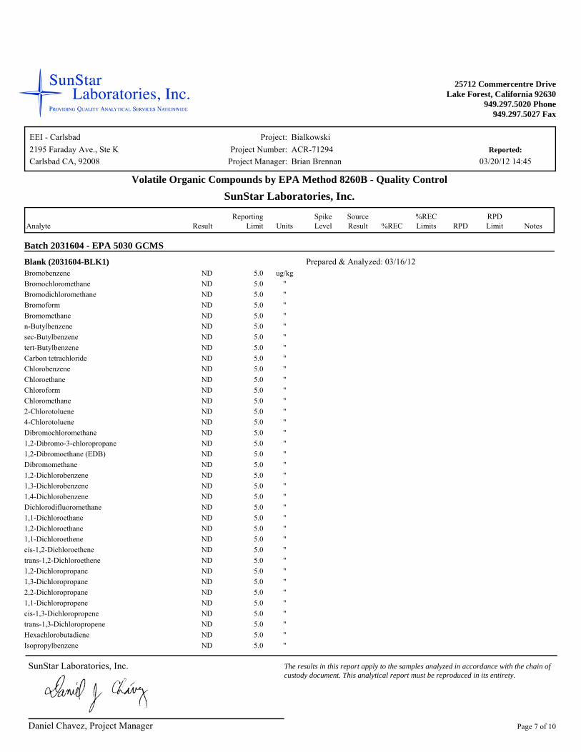
Volatile Organic Compounds by EPA Method 8260B - Quality ControlSunStar Laboratories, Inc.
Batch 2031604 - EPA 5030 GCMS
Blank (2031604-BLK1) Prepared & Analyzed: 03/16/12 Bromobenzene ug/kgND 5.0Bromochloromethane "ND 5.0Bromodichloromethane "ND 5.0Bromoform "ND 5.0Bromomethane "ND 5.0n-Butylbenzene "ND 5.0sec-Butylbenzene "ND 5.0tert-Butylbenzene "ND 5.0Carbon tetrachloride "ND 5.0Chlorobenzene "ND 5.0Chloroethane "ND 5.0Chloroform "ND 5.0Chloromethane "ND 5.02-Chlorotoluene "ND 5.04-Chlorotoluene "ND 5.0Dibromochloromethane "ND 5.01,2-Dibromo-3-chloropropane "ND 5.01,2-Dibromoethane (EDB) "ND 5.0Dibromomethane "ND 5.01,2-Dichlorobenzene "ND 5.01,3-Dichlorobenzene "ND 5.01,4-Dichlorobenzene "ND 5.0Dichlorodifluoromethane "ND 5.01,1-Dichloroethane "ND 5.01,2-Dichloroethane "ND 5.01,1-Dichloroethene "ND 5.0cis-1,2-Dichloroethene "ND 5.0trans-1,2-Dichloroethene "ND 5.01,2-Dichloropropane "ND 5.01,3-Dichloropropane "ND 5.02,2-Dichloropropane "ND 5.01,1-Dichloropropene "ND 5.0cis-1,3-Dichloropropene "ND 5.0trans-1,3-Dichloropropene "ND 5.0Hexachlorobutadiene "ND 5.0Isopropylbenzene "ND 5.0
Daniel Chavez, Project Manager
SunStar Laboratories, Inc. The results in this report apply to the samples analyzed in accordance with the chain of custody document. This analytical report must be reproduced in its entirety.
Page 7 of 10
Project:Project Number:
Project Manager:Reported:
EEI - Carlsbad2195 Faraday Ave., Ste K ACR-71294
Brian Brennan
Bialkowski
03/20/12 14:45Carlsbad CA, 92008
25712 Commercentre DriveLake Forest, California 92630
949.297.5020 Phone949.297.5027 Fax
Result LimitReporting
Units LevelSpike
ResultSource
%REC%RECLimits RPD
RPDLimit Notes Analyte
Volatile Organic Compounds by EPA Method 8260B - Quality ControlSunStar Laboratories, Inc.
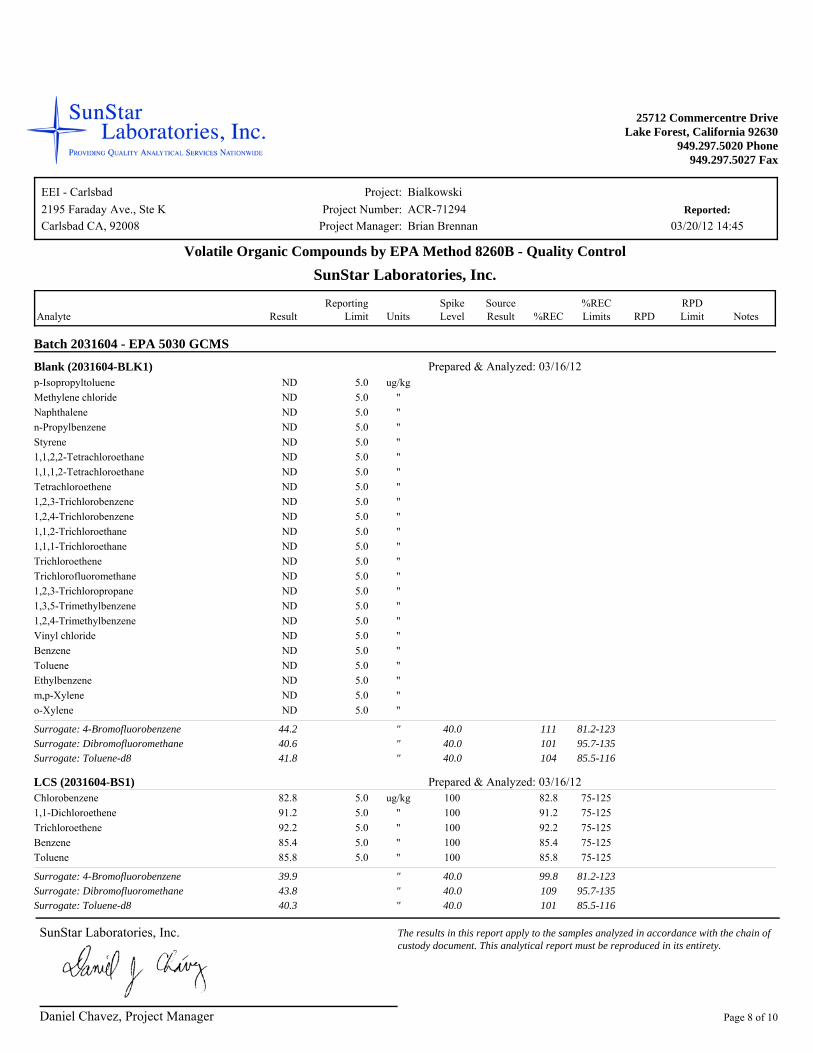
Batch 2031604 - EPA 5030 GCMS
Blank (2031604-BLK1) Prepared & Analyzed: 03/16/12 p-Isopropyltoluene ug/kgND 5.0Methylene chloride "ND 5.0Naphthalene "ND 5.0n-Propylbenzene "ND 5.0Styrene "ND 5.01,1,2,2-Tetrachloroethane "ND 5.01,1,1,2-Tetrachloroethane "ND 5.0Tetrachloroethene "ND 5.01,2,3-Trichlorobenzene "ND 5.01,2,4-Trichlorobenzene "ND 5.01,1,2-Trichloroethane "ND 5.01,1,1-Trichloroethane "ND 5.0Trichloroethene "ND 5.0Trichlorofluoromethane "ND 5.01,2,3-Trichloropropane "ND 5.01,3,5-Trimethylbenzene "ND 5.01,2,4-Trimethylbenzene "ND 5.0Vinyl chloride "ND 5.0Benzene "ND 5.0Toluene "ND 5.0Ethylbenzene "ND 5.0m,p-Xylene "ND 5.0o-Xylene "ND 5.0
" 40.0 81.2-123Surrogate: 4-Bromofluorobenzene 11144.2" 40.0 95.7-135Surrogate: Dibromofluoromethane 10140.6" 40.0 85.5-116Surrogate: Toluene-d8 10441.8
LCS (2031604-BS1) Prepared & Analyzed: 03/16/12 Chlorobenzene ug/kg82.8 5.0 100 75-12582.81,1-Dichloroethene "91.2 5.0 100 75-12591.2Trichloroethene "92.2 5.0 100 75-12592.2Benzene "85.4 5.0 100 75-12585.4Toluene "85.8 5.0 100 75-12585.8
" 40.0 81.2-123Surrogate: 4-Bromofluorobenzene 99.839.9" 40.0 95.7-135Surrogate: Dibromofluoromethane 10943.8" 40.0 85.5-116Surrogate: Toluene-d8 10140.3
Daniel Chavez, Project Manager
SunStar Laboratories, Inc. The results in this report apply to the samples analyzed in accordance with the chain of custody document. This analytical report must be reproduced in its entirety.
Page 8 of 10
Project:Project Number:
Project Manager:Reported:
EEI - Carlsbad2195 Faraday Ave., Ste K ACR-71294
Brian Brennan
Bialkowski
03/20/12 14:45Carlsbad CA, 92008
25712 Commercentre DriveLake Forest, California 92630
949.297.5020 Phone949.297.5027 Fax
Result LimitReporting
Units LevelSpike
ResultSource
%REC%RECLimits RPD
RPDLimit Notes Analyte
Volatile Organic Compounds by EPA Method 8260B - Quality ControlSunStar Laboratories, Inc.
Batch 2031604 - EPA 5030 GCMS
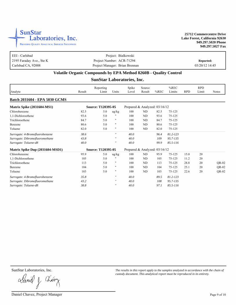
Matrix Spike (2031604-MS1) Prepared & Analyzed: 03/16/12 Source: T120395-05Chlorobenzene ug/kg82.5 5.0 100 ND 75-12582.51,1-Dichloroethene "93.6 5.0 100 ND 75-12593.6Trichloroethene "84.7 5.0 100 ND 75-12584.7Benzene "80.6 5.0 100 ND 75-12580.6Toluene "82.0 5.0 100 ND 75-12582.0
" 40.0 81.2-123Surrogate: 4-Bromofluorobenzene 96.438.6" 40.0 95.7-135Surrogate: Dibromofluoromethane 10943.8" 40.0 85.5-116Surrogate: Toluene-d8 99.940.0
Matrix Spike Dup (2031604-MSD1) Prepared & Analyzed: 03/16/12 Source: T120395-05Chlorobenzene ug/kg95.9 5.0 100 ND 2075-12595.9 15.01,1-Dichloroethene "105 5.0 100 ND 2075-125105 11.2Trichloroethene "113 5.0 100 ND 20 QR-0275-125113 28.8Benzene "104 5.0 100 ND 20 QR-0275-125104 25.1Toluene "103 5.0 100 ND 20 QR-0275-125103 22.6
" 40.0 81.2-123Surrogate: 4-Bromofluorobenzene 89.535.8" 40.0 95.7-135Surrogate: Dibromofluoromethane 10843.2" 40.0 85.5-116Surrogate: Toluene-d8 97.138.8
Daniel Chavez, Project Manager
SunStar Laboratories, Inc. The results in this report apply to the samples analyzed in accordance with the chain of custody document. This analytical report must be reproduced in its entirety.
Page 9 of 10
Project:Project Number:
Project Manager:Reported:
EEI - Carlsbad2195 Faraday Ave., Ste K ACR-71294
Brian Brennan
Bialkowski
03/20/12 14:45Carlsbad CA, 92008
25712 Commercentre DriveLake Forest, California 92630
949.297.5020 Phone949.297.5027 Fax
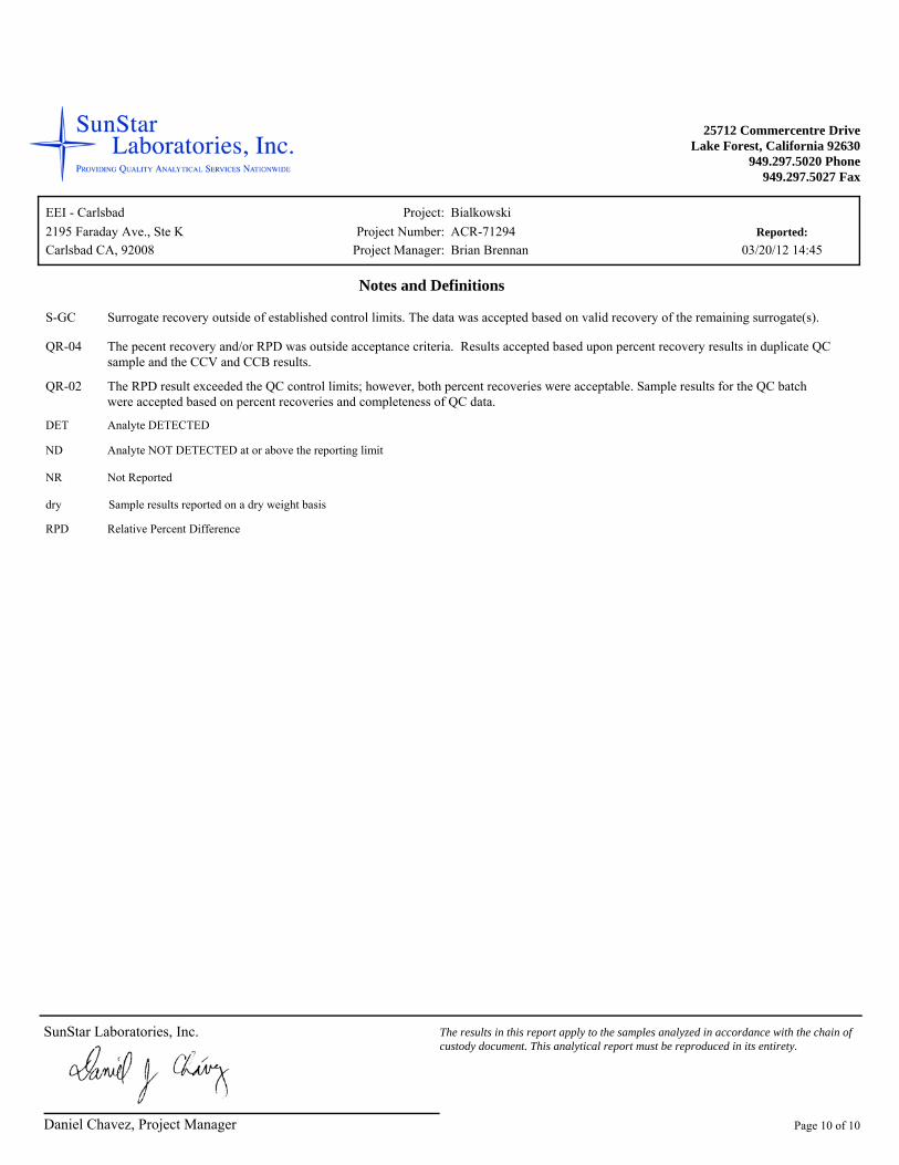
Notes and Definitions
S-GC Surrogate recovery outside of established control limits. The data was accepted based on valid recovery of the remaining surrogate(s).
QR-04 The pecent recovery and/or RPD was outside acceptance criteria. Results accepted based upon percent recovery results in duplicate QC sample and the CCV and CCB results.
QR-02 The RPD result exceeded the QC control limits; however, both percent recoveries were acceptable. Sample results for the QC batch were accepted based on percent recoveries and completeness of QC data.
Sample results reported on a dry weight basis
Relative Percent DifferenceRPD
dry
Not ReportedNR
Analyte NOT DETECTED at or above the reporting limitND
Analyte DETECTEDDET
Daniel Chavez, Project Manager
SunStar Laboratories, Inc. The results in this report apply to the samples analyzed in accordance with the chain of custody document. This analytical report must be reproduced in its entirety.
Page 10 of 10

2195 Faraday Avenue Suite KCarlsbad, California 92008-7207 Ph: 760-431-3747Fax: 760-431-3748www.eeitiger.com
PHASE I ENVIRONMENTAL
SITE ASSESSMENT
and
LIMITED AGRICULTURAL
CHEMICAL SURVEY
Accretive Investments, Inc.
12.72-Acre “Dawson” Property
APNs 129-011-16 and 129-011-17
Escondido, California 92026
County Project Number: SP 3800 12-001; Lilac Hills Ranch
Environmental Log Number: 3910 12-02-003
April 18, 2012
EEI Project Number ACR-71445
PHASE I ENVIRONMENTAL SITE ASSESSMENT AND LIMITED AGRICULTURAL CHEMCIAL SURVEY Prepared for: Mr. Jon Rilling Vice President Accretive Investments, Inc. 12275 El Camino Real, Suite 110 San Diego, California 92130 Subject property location: 12.72-Acre ñDawsonò Property APNs 129-011-16 and 129-011-17 Escondido, California 92026 EEI Project Number ACR-71445 Prepared and Edited by:
Brian R. Brennan, REA-II 07920 Senior Project Manager Reviewed by: Bernard A. Sentianin, PG 5530, REA I 3477 Principal Geologist EEI 2195 Faraday Avenue, Suite K Carlsbad, California 92008 (760) 431-3747 EEI Project No. ACR-71445
TABLE OF CONTENTS
GENERAL SUBJECT PROPERTY INFORMATION ............................................................................ i EXECUTIVE SUMMARY .........................................................................................................................ii 1.0 INTRODUCTION ................................................................................................................................. 1
1.1 Purpose ....................................................................................................................................... 1 1.2 Scope of Services ........................................................................................................................ 1 1.3 Reliance ...................................................................................................................................... 2
2.0 PHYSIOGRAPHIC SETTING ............................................................................................................ 2
2.1 Subject Property Description ...................................................................................................... 2 2.2 Topography ................................................................................................................................. 2 2.3 Regional and Local Geology ...................................................................................................... 3 2.4 Regional and Local Hydrogeology ............................................................................................. 3 2.5 Hydrologic Flood Plain Information ........................................................................................... 4
3.0 SUBJECT PROPERTY BACKGROUND ......................................................................................... 4
3.1 Subject Property Ownership ....................................................................................................... 4 3.2 Subject Property History ............................................................................................................. 5
3.2.1 Aerial Photograph and Historical Map Review .......................................................... 5 TABLE 1 - Summary of Historical Use Review .................................................................. 5 3.2.2 City/County Directories .............................................................................................. 6 TABLE 2 ï Summary of City/County Directory Search...................................................... 6 3.2.3 Sanborn Fire Insurance Maps ..................................................................................... 6 3.2.4 County of San Diego Land Use and Environmental Group ........................................ 6
3.3 Regulatory Database Search ....................................................................................................... 6 3.3.1 Federal Databases ....................................................................................................... 6 3.3.2 State and Regional Sources ........................................................................................ 7
3.4 Regulatory Agency Review ........................................................................................................ 8 3.4.1 Deer Springs Fire Protection District .......................................................................... 8 3.4.2 County of San Diego Department of Environmental Health....................................... 8 3.4.3 State Water Resources Control Board ........................................................................ 8 3.4.4 Department of Toxic Substances Control ................................................................... 8 3.4.5 Review of Division of Oil, Gas, and Geothermal Resources Files ............................. 8 3.4.6 National Pipeline Mapping System ............................................................................ 9
3.5 Interview with Current Property Owner ..................................................................................... 9 3.5.1 Past or Present Uses Indicating Environmental Concern ............................................ 9 3.5.2 Environmental Liens or Governmental Notification ................................................... 9 3.5.3 Presence of Hazardous Substances or Environmental Violations ............................... 9 3.5.4 Previous Assessments ................................................................................................. 9 3.5.5 Legal Proceedings ....................................................................................................... 9 3.6 User Provided Information ......................................................................................................... 9 3.6.1 Environmental Liens or Activity and Use Limitations ............................................... 10
3.6.2 Specialized Knowledge ............................................................................................ 10 3.6.3 Valuation Reduction for Environmental Issues ........................................................ 10 3.6.4 Presence or Likely Presence of Contamination ......................................................... 10 3.6.5 Other ......................................................................................................................... 10
3.7 Previous Assessments ............................................................................................................... 10
TABLE OF CONTENTS (Continued) 3.8 Other Environmental Issues ...................................................................................................... 10
3.8.1 Asbestos-Containing Materials ................................................................................. 10 3.8.2 Lead-Based Paint ...................................................................................................... 11 3.8.3 Radon ....................................................................................................................... 11 3.8.4 Polychlorinated Biphenyls ........................................................................................ 11
4.0 SUBJECT PROPERTY RECONNAISSANCE ............................................................................... 12
4.1 Purpose ..................................................................................................................................... 12 4.2 Subject Property ....................................................................................................................... 12 TABLE 3 ï Summary of Subject Property Reconnaissance ........................................................... 13 4.3 Adjacent Properties................................................................................................................... 13
5.0 LIMITED AGRICULTURAL CHEMICAL SURVEY .................................................................. 14
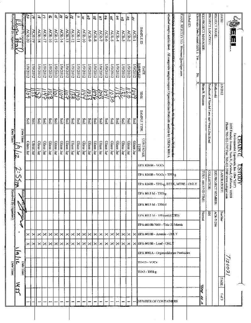
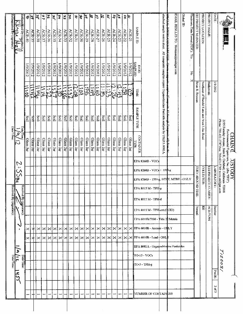
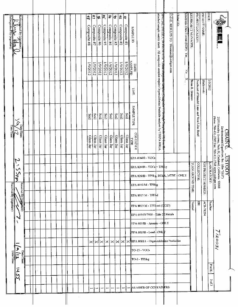
5.1 Field Investigation .................................................................................................................... 14 5.2 Laboratory Analytical Program ................................................................................................. 14 TABLE 4 - Soil Sample Results ..................................................................................................... 15 5.3 Discussion of Testing Results ................................................................................................... 15
6.0 FINDINGS AND OPINIONS ............................................................................................................. 16 7.0 DATA GAPS AND DEVIATIONS FROM ASTM PRACTICES ................................................... 16
7.1 Historical Data Gaps ................................................................................................................. 16 7.2 Regulatory Data Gaps ............................................................................................................... 16 7.3 On-site Data Gaps ..................................................................................................................... 17 7.4 Deviations from ASTM Practices ............................................................................................. 17
8.0 CONCLUSIONS .................................................................................................................................. 17 9.0 REFERENCES .................................................................................................................................... 18
FIGURES:
Figure 1 ï Site Location Map Figure 2 ï Aerial Site Map Figure 3 ï Soil Boring Location Map
APPENDICES: Appendix A ï R®sum® of Environmental Professional
Appendix B ï San Diego County Assessorôs Parcel Map Appendix C ï Aerial Photographs/Topographic Maps Appendix D ï Environmental Records Search Appendix E ï User Provided Information Appendix F ï Photographic Log Appendix G ï Limited Agricultural Chemical Survey Laboratory Report and Chain of Custody
i
GENERAL SUBJECT PROPERTY INFORMATION Project Information: 12.72-Acre ñDawsonò Property EEI Project Number: ACR-71445 Subject Property Information: APNs 129-011-16 and 129-011-17 Escondido, California 92026 EEI Project Number ACR-71445 Subject Property Access Contact: Mr. Jon Rilling, Accretive Investments, Inc. (858) 345-3644 Consultant Information: EEI 2195 Faraday Avenue, Suite K Carlsbad, California 92008 Phone: (760) 431-3747 Fax: (760) 431-3748 E-mail Address of Environmental Professional: [email protected] Inspection Date: March 14, 2012 / Report Date: April 18, 2012 Client Information: Mr. Jon Rilling Vice President Accretive Investments, Inc. 12275 El Camino Real, Suite 110 San Diego, California 92130 Site Assessor: Brian R. Brennan, REA-II 07920 ï Senior Project Manager EP Certification: I declare that, to the best of my professional knowledge and belief, I meet the definition of Environmental Professional as defined in 40 CFR 312.10 (Resume, Appendix A).
Brian R. Brennan, REA-II 07920 ï Senior Project Manager AAI Certification: We have the specific qualifications based on education, training, and experience to assess a property of the nature, history, and setting of the subject property. We have developed and performed the all appropriate inquiries in conformance with the standards and practices set forth in 40 CFR Part 312.
Brian R. Brennan, REA-II 07920 ï Senior Project Manager
Phase I ESA and Limited Agricultural Survey April 18, 2012 Accretive Investments, Inc., ñDawsonò Property ï Escondido, CA EEI Project No. ACR-71445
ii
EXECUTIVE SUMMARY At the request and authorization of Accretive Investments, Inc. (ñClientò), EEI conducted a Phase I Environmental Site Assessment (ESA) for the property located approximately 500 feet north of the intersection of Rodriguez Road and Nelson Way, Escondido, California. The purpose of this Phase I ESA was to assess the presence or likely presence of an existing, historical, or threatened release of any hazardous substances or petroleum products into structures, soil, and/or groundwater beneath the subject property, to the extent practical (i.e., recognized environmental conditions as delineated in ASTM E1527-05). The subject property encompasses a total of 12.72-acres on two contiguous parcels identified as Assessorôs Parcel Numbers (APNs) 129-011-16 and 129-011-17. According to the County of San Diego Assessor, the subject property does not have a physical address. Access to the subject property can be obtained from the east at Rodriguez Road, where an unimproved access road traverses the northern portion of the property from east to west. The subject property consists of agricultural land including field crops and an existing orchard grove in the western portion. A single, wood structure is located in the northwest portion of the property, and appeared to be used by the farm workers as a staging area and for agricultural activities. A review of the County of San Diego Land Use and Environmental Group (LUEG, 2012) website data indicated that the subject property is currently zoned as A70 ï Limited Agriculture. Based on historical records such as aerial photographs, topographic maps, and County records, the subject property, from approximately 1947 to 2012, the subject property appeared utilized for agricultural-related land use. EEI contacted the County of San Diego, California Department of Toxic Substances Control (DTSC), State Water Resources Control Board (SWRCB), and reviewed other State and Federal databases to determine if the subject property, or any adjacent properties, were listed as hazardous waste generators, underground storage tank releases (UST), or as having other environmental concerns (i.e., spill, leak, or aboveground tank). No releases/leaks or spills were documented at the subject property on any of the databases researched. March 16, 2012, EEI personnel conducted a reconnaissance of the subject property to physically observe the property and adjoining properties for conditions indicating a potential environmental concern. Concerns would include any evidence of contamination, distressed vegetation, petroleum-hydrocarbon staining, waste drums, illegal dumping, or improper waste storage and/or handling. No evidence of environmental conditions (RECs) was noted on the subject property during our subject property reconnaissance efforts. Based on the historical agricultural use of the property, EEI performed a limited agricultural chemical survey to evaluate soil beneath the subject property. Sampling activities were conducted on March 16, 2012. A total of 12 discrete soil samples (ACR-1 through ACR-12), were collected at 6-inches below ground surface and analyzed for Arsenic and Lead by EPA Test Method 6010B. Additionally, four (4) composite samples (Composite #1 through Composite #4) (prepared by a California-State certified laboratory), were analyzed for Organochlorine Pesticides by EPA Method 8081A. The results of our agricultural chemical survey revealed that no concentrations of arsenic or organochlorine pesticides were detected above the laboratory reporting limit (i.e., ñnon-detectò) in the soil samples collected from the subject property. Lead was detected above the laboratory reporting limit in samples ACR-3 and ACR-10 at 4.9 milligrams per kilogram (mg/kg) and 4.3 mg/kg, respectively. No other samples analyzed detected lead above the laboratory reporting limit (i.e., ñnon-detectò).
Phase I ESA and Limited Agricultural Survey April 18, 2012 Accretive Investments, Inc., ñDawsonò Property ï Escondido, CA EEI Project No. ACR-71445
iii
The reported lead concentrations of 4.9 mg/kg and 4.3 mg/kg in soil samples collected during this investigation are less than the residential California Human Health Screening Level (CHHSL) value of 150 mg/kg; therefore, further investigation does not appear to be warranted. Furthermore, the lead concentrations appear to represent background levels inherent to the site vicinity. Trace or background levels for soils within central and southwestern San Diego County range from 15.6 mg/kg to 57.1 mg/kg (Kearney Foundation Special Report, 1996). We have performed a Phase I Environmental Site Assessment (ESA) in conformance with the scope and limitations of ASTM Designation E1527-05 for the subject property identified as APN 129-011-06 and -17, and located northwest of Rodriguez Road and Nelson Way, Escondido, California. Any exceptions to, or deletions from, this practice are described in Section 7.0 of this report. Phase I ESA has revealed no evidence of recognized environmental conditions in connection with the property. In addition EEI has the following comment:
Based on the subject propertyôs historical agricultural use, it is possible that buried/concealed/hidden
agricultural by-products, both below and above ground may have existed or exists on the subject property. Any buried trash/debris, or other waste encountered during future subject property development should be evaluated by an experienced environmental consultant prior to removal. If stained or suspicious soil is encountered during future grading operations, the material should be evaluated and if deemed necessary, characterized for proper disposal.
Phase I ESA and Limited Agricultural Survey April 18, 2012 Accretive Investments, Inc., ñDawsonò Property ï Escondido, CA EEI Project No. ACR-71445
1
1.0 INTRODUCTION 1.1 Purpose The purpose of this Phase I Environmental Site Assessment (ESA) was to assess the possible presence of recognized environmental conditions at the property located approximately 500 feet north of the intersection of Rodriguez Road and Nelson Way, Escondido, California (Figure 1). Recognized environmental conditions include those property uses that may indicate the presence or likely presence of an existing, historical, or threatened release of any hazardous substances or petroleum products into structures, soil, and/or groundwater beneath the property. The term recognized environmental conditions are not intended to include de minimis conditions that generally do not present a material risk of harm to public health or the environment and that would not be subject to enforcement actions by a regulatory agency. This ESA was performed in general conformance with the American Society for Testing and Materials (ASTM) Standard Practice for Environmental Site Assessments: Phase I Environmental Site Assessment Process, Designation E1527-05. 1.2 Scope of Services The following scope of services was conducted by EEI:
Å A review of readily available documents which included topographic, geologic, and hydrogeologic conditions associated with the subject property.
Å A review of readily available maps, aerial photographs, and other documents relative to historical
subject property usage and development. Å A review of previous environmental reports and regulatory file information pertaining to both existing
and historic property conditions.
Å A review of readily available federal, state, county, and city documents and database files concerning hazardous material storage, generation and disposal, active and inactive landfills, existing environmental concerns, and associated permits related to the subject property and/or immediately adjacent sites.
Å A subject property reconnaissance to ascertain current conditions on the subject property.
Å Interviews with person(s) knowledgeable of the subject property.
Å A limited agricultural chemical survey, which consisted of collecting and analyzing soil samples from
the subject property.
Å The preparation of this report which presents our findings, conclusions, and recommendations.
Phase I ESA and Limited Agricultural Survey April 18, 2012 Accretive Investments, Inc., ñDawsonò Property ï Escondido, CA EEI Project No. ACR-71445
2
1.3 Reliance This ESA has been prepared for the sole use of Accretive Investments, Inc. (Client). This assessment should not be relied upon by other parties without the express written consent of EEI and Client. Any use or reliance upon this assessment by a party other than the Client, therefore, shall be solely at the risk of such third party and without legal recourse against EEI, its employees, officers, or directors, regardless of whether the action in which recovery of damages is brought or based upon contract, tort, statute or otherwise. This assessment should not be interpreted as a statistical evaluation of the subject property, but rather is intended to provide a preliminary indication of on-site impacts from previous property usage and/or the release of hazardous materials. If no significant indicators of the presence of hazardous materials and/or petroleum contamination are encountered during this search, this does not preclude their presence. The findings in this report are based upon published geologic and hydrogeologic information, information (both documentary and oral) provided by the County of San Diego, FirstSearchÈ (i.e., agency database search), various state and federal agencies, and EEIôs field observations. Some of these data are subject to change over time. Some of these data are based on information not currently observable or measurable, but recorded by documents or orally reported by individuals. 2.0 PHYSIOGRAPHIC SETTING 2.1 Subject Property Description The subject property is located approximately 500 feet north of the intersection of Rodriguez Road and Nelson Way, Escondido, California (Figure 2). The subject property encompasses a total of 12.72-acres on two contiguous parcels identified as Assessorôs Parcel Numbers (APNs) 129-011-16 and 129-011-17 (Appendix B). According to the County of San Diego Assessor, the subject property does not have a physical address. Access to the subject property can be obtained from the east at Rodriguez Road, where an unimproved access road traverses the northern portion of the property from east to west. The subject property consists of agricultural land including field crops and an existing orchard grove in the western portion. A single, wood structure is located in the northwest portion of the property, and appeared to be used by the farm workers as a staging area for agricultural activities. A review of the County of San Diego Land Use and Environmental Group (LUEG, 2012) website data indicated that the subject property is currently zoned as A70 ï Limited Agriculture. Based on historical records such as aerial photographs, topographic maps, and County records, the subject property, from approximately 1947 to 2012, the subject property appeared utilized for agricultural-related land use. 2.2 Topography The subject property is located on the United States Geological Survey (USGS), Pala, 7.5-Minute Quadrangle (USGS, 1997). Overall, the subject property is located on gently sloping terrain consisting of varying topographic relief from north to south. The subject property elevation ranges from approximately 840 feet above mean sea level (amsl) (northwestern portion) to approximately 900 feet amsl (southeastern portion). Based on topographic relief, surface water drainage appears to be predominately to the northeast.
Phase I ESA and Limited Agricultural Survey April 18, 2012 Accretive Investments, Inc., ñDawsonò Property ï Escondido, CA EEI Project No. ACR-71445
3
2.3 Regional and Local Geology The subject property and vicinity lies within the Peninsular Ranges Geomorphic Province of California (CGS, 2002). The Peninsular Ranges Geomorphic Province extends from the Transverse Ranges Geomorphic Province and the Los Angeles Basin, south to Baja California. This province varies in width from about 30- to 100-miles. It is bounded on the west by the Pacific Ocean, on the south by the Gulf of California and on the east by the Colorado Desert Province. The Peninsular Ranges are essentially a series of northwest-southeast oriented fault blocks. The Transverse Ranges Geomorphic Province bounds the Peninsular Ranges on the north. Major fault zones and subordinate fault zones found in the Peninsular Ranges Province typically trend in a northwest-southeast direction. The closest major faults to the subject property are the Julian segment of the Elsinore Fault zone; the Rose Canyon Fault zone; and the Coronado Bank Fault zone (including the San Diego Trough Fault). Other major faults in the region include the San Jacinto Fault zone and the San Andreas Fault zone. The San Andreas Fault zone is considered the most active fault zone and borders the northeasterly margin of the province. Geologic maps indicate the general vicinity of the subject property is underlain by Mesozoic aged (Cretaceous-age) granitic rocks (USGS, 2000). Specifically, the property is underlain by Tonalite of Couser Canyon, described as a Hornblende-biotite tonalite; coarse grained and massive. This Tonalite contain some granodiorite and is characterized by an abundance of pegmatite dikes. Soils beneath the site and in the vicinity of the site have been identified by the United States Department of Agriculture ï Natural Resources Conservation Service, Web Soil Survey as the Bonsall Sandy Loam (BID2); Cieneba Coarse Sandy Loam (CIE2); and steep gullied land (StG) (USDA, 2012). Soils in these series are reportedly well drained soils that formed in material weathered from granitic rocks and are situated on slopes ranging from 9 to 30 percent. 2.4 Regional and Local Hydrogeology According to the San Diego Regional Water Quality Control Board (SDRWQCB, 1994), the subject property is located within the groundwater designation of the Bonsall Subarea (HSA ï 903.12), which is a part of the lower San Luis Hydrologic Area (HA ï 903.10) and located within the San Luis Rey Hydrologic Unit (HU ï 903.00). Groundwater beneath the San Luis HA has been identified as having existing beneficial uses for municipal, agricultural, and industrial supply processes. EEI contacted the County of San Diego Department of Environmental Health, Land and Water Quality Division, for information pertaining to any water supply well permits associated with the subject property. According to Ms. Sandy Johnson Senior Office Assistant, Department of Environmental Health Land & Water Quality Division, there are no records associated with the two subject parcels APNs 129-011-16 and -17. EEI reviewed the California Department of Water Resources, Water Data Library website (WDL, 2012) for more information pertaining any well(s) on or adjacent to the subject property. According to the website no water supply wells were located on the subject property. Two (2) water supply wells were located in close proximity to the northern subject property boundary. One well was located to the northeast (well 10S02W29E002S) and a second well was located to the east (well 10S02W29E001S). According to the website, the wells were last measured in 1967, and indicated that the depth-to-groundwater in the wells were recorded at 36 feet below ground surface (bgs) and 34 feet bgs, respectively.
Phase I ESA and Limited Agricultural Survey April 18, 2012 Accretive Investments, Inc., ñDawsonò Property ï Escondido, CA EEI Project No. ACR-71445
4
2.5 Hydrologic Flood Plain Information EEI reviewed the Federal Emergency Management Agency (FEMA, 2012) Flood Insurance Rate Map (FIRM) online database to determine if the subject property was in a flood zone. According to FEMA, FIRM coverage for the subject property was not available for review (Panel No. 06073C0492F). EEI reviewed the San Diego Geographic Information Source website (SanGIS, 2012) for flood plain information. According to the website, the subject property is located within flood Zone X. FEMA defines Zone X as an area of minimal flood hazard, usually depicted on FIRMs as above the 500-year flood level. 3.0 SUBJECT PROPERTY BACKGROUND 3.1 Subject Property Ownership According to the County of San Diego Assessor the current owner of the subject property (APNs 129-011-16 and 129-011-17) is identified as Clyde and Ethel Dawson Survivor Trust, with the following mailing address: c/o Larry Dawson, 9842 Hot Springs Drive, Huntington Beach, California 92646. 3.2 Subject Property History EEI reviewed readily available information sources to evaluate historic land use in and around the subject property. These information sources include information from aerial photographs, USGS maps and the County of San Diego. The information sources reviewed is summarized in the following sections.
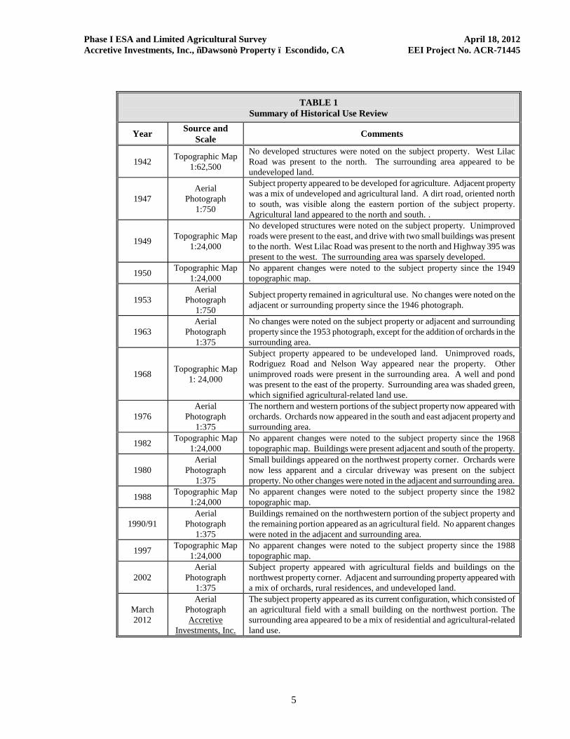
3.2.1 Aerial Photograph and Historical Map Review Aerial photographs and historical topographical maps were reviewed to identify historical land development and any surface conditions which may have impacted the subject property. Photographs and historical topographic maps dating 1942, 1947, 1949, 1950, 1953, 1963, 1968, 1976, 1980, 1982, 1988, 1990-91, 1997, and 2002 were obtained and reviewed from Track Info Services/FirstSearchÈ, an environmental information/database retrieval service. A 2012 aerial photograph was provided by Accretive Investments, Inc. and reviewed, a copy of which is included herein (Figure 2). Table 1 summarizes the results of the historical use review. Copies of the aerial photographs and historical topographic maps provided by Track Info Services/FirstSearchÈ are included in Appendix C. According to the information reviewed, from approximately 1947 to 2010, the subject property appeared utilized for agricultural-related land use.
Phase I ESA and Limited Agricultural Survey April 18, 2012 Accretive Investments, Inc., ñDawsonò Property ï Escondido, CA EEI Project No. ACR-71445
5
TABLE 1 Summary of Historical Use Review
Year Source and Scale Comments
1942 Topographic Map 1:62,500
No developed structures were noted on the subject property. West Lilac Road was present to the north. The surrounding area appeared to be undeveloped land.
1947 Aerial
Photograph 1:750
Subject property appeared to be developed for agriculture. Adjacent property was a mix of undeveloped and agricultural land. A dirt road, oriented north to south, was visible along the eastern portion of the subject property. Agricultural land appeared to the north and south. .
1949 Topographic Map 1:24,000
No developed structures were noted on the subject property. Unimproved roads were present to the east, and drive with two small buildings was present to the north. West Lilac Road was present to the north and Highway 395 was present to the west. The surrounding area was sparsely developed.
1950 Topographic Map 1:24,000
No apparent changes were noted to the subject property since the 1949 topographic map.
1953 Aerial
Photograph 1:750
Subject property remained in agricultural use. No changes were noted on the adjacent or surrounding property since the 1946 photograph.
1963 Aerial
Photograph 1:375
No changes were noted on the subject property or adjacent and surrounding property since the 1953 photograph, except for the addition of orchards in the surrounding area.
1968 Topographic Map 1: 24,000
Subject property appeared to be undeveloped land. Unimproved roads, Rodriguez Road and Nelson Way appeared near the property. Other unimproved roads were present in the surrounding area. A well and pond was present to the east of the property. Surrounding area was shaded green, which signified agricultural-related land use.
1976 Aerial
Photograph 1:375
The northern and western portions of the subject property now appeared with orchards. Orchards now appeared in the south and east adjacent property and surrounding area.
1982 Topographic Map 1:24,000
No apparent changes were noted to the subject property since the 1968 topographic map. Buildings were present adjacent and south of the property.
1980 Aerial
Photograph 1:375
Small buildings appeared on the northwest property corner. Orchards were now less apparent and a circular driveway was present on the subject property. No other changes were noted in the adjacent and surrounding area.
1988 Topographic Map 1:24,000
No apparent changes were noted to the subject property since the 1982 topographic map.
1990/91 Aerial
Photograph 1:375
Buildings remained on the northwestern portion of the subject property and the remaining portion appeared as an agricultural field. No apparent changes were noted in the adjacent and surrounding area.
1997 Topographic Map 1:24,000
No apparent changes were noted to the subject property since the 1988 topographic map.
2002 Aerial
Photograph 1:375
Subject property appeared with agricultural fields and buildings on the northwest property corner. Adjacent and surrounding property appeared with a mix of orchards, rural residences, and undeveloped land.
March 2012
Aerial Photograph Accretive
Investments, Inc.
The subject property appeared as its current configuration, which consisted of an agricultural field with a small building on the northwest portion. The surrounding area appeared to be a mix of residential and agricultural-related land use.
Phase I ESA and Limited Agricultural Survey April 18, 2012 Accretive Investments, Inc., ñDawsonò Property ï Escondido, CA EEI Project No. ACR-71445
6
3.2.2 City/County Directory Due to the absence of development of the subject property or an associated physical address, this information source was not researched as it was not deemed to be sufficiently useful and not researched during this Phase I ESA. 3.2.3 Sanborn Fire Insurance Maps
Sanborn Fire Insurance maps were developed in the late 1800s and early 1900s for use as an assessment tool for fire insurance rates in urbanized areas. An on-line search was made at the Los Angeles County Public Libraryôs collection of Sanborn Fire Insurance maps (LAPL, 2012). Sanborn map coverage was not available for the subject property and/or surrounding area; therefore, indicating little or no development prior to the 1950s. 3.2.4 County of San Diego Land Use and Environmental Group EEI researched the County of San Diego Land Use and Environmental Group (LUEG) website to review any existing records related to development of the subject property. According to the online database maintained by the County (LUEG, 2012), no records were on file for the two subject property parcels APNs: 129-011-16 and 129-011-17. In addition, EEI requested a search for environmental records (i.e., wells or septic tanks) with the County. According to Ms. Sandy Johnson Senior Office Assistant, Department of Environmental Health Land & Water Quality Division, there are no records associated with the two subject parcels APNs 129-011-16 and -17.
3.3 Regulatory Database Search EEI reviewed known electronic database listings for possible hazardous waste generating establishments in the vicinity of the subject property, as well as adjacent sites with known environmental concerns. Facilities were identified by county, state, or federal agencies that generate, store, or dispose of hazardous materials. The majority of information in this section was obtained from FirstSearchÈ, an environmental information/database retrieval service. A copy of the FirstSearchÈ report is provided in Appendix D, along with a description of the individual databases. The subject property was not listed on any of the databases researched.
3.3.1 Federal Databases National Priority List (NPL) ï No listings were reported within one mile of the subject property. NPL Delisted ï No listings were reported within one-half mile of the subject property. Comprehensive Environmental Response, Compensation, and Liability Information System (CERCLIS) ï No listings were reported within one-half mile of the subject property. CERCLIS (NFRAP) Archive ï No listings were reported within one-half mile of the subject property.
Phase I ESA and Limited Agricultural Survey April 18, 2012 Accretive Investments, Inc., ñDawsonò Property ï Escondido, CA EEI Project No. ACR-71445
7
Resource Conservation and Recovery Information System (RCRA) Corrective Action Sites (COR) ï No listings were reported within one mile of the subject property. RCRA TSD Facility List (RCRA-D) ï No listings were reported within one-half mile of the subject property. RCRA Generators (RCRA-G) ï No listings were reported within one-quarter mile of the subject property. RCRA No Longer Regulated (NLR) ï No listings were reported within one-eighth mile of the subject property. Federal IC/EC ï No listings were reported within one-quarter mile of the subject property. Emergency Response Notification System (ERNS) ï No listings were reported within one-eighth mile of the subject property. The subject property was not identified on any of the above-referenced databases researched. 3.3.2 State and Regional Sources Tribal Lands ï One listing was reported: Bureau of Indian Affairs Contact I. Tribal Lands listing are not generally considered rationale for environmental concern, unless the facility has a dual listing, such as a reported release. The listing does not have a dual listing or reported release; therefore, is not considered to be an environmental concern at this time. State/Tribal Sites ï No listings were reported within one mile of the subject property. State Spills 90 ï No listings were reported within one-eighth mile of the subject property. State/Tribal Solid Waste Landfill (SWL) Sites ï No listings were reported within one-half mile of the subject property. State/Tribal California State Leaking Underground Storage Tanks (LUST) ï No listings were reported within one-half mile of the subject property. State/Tribal Permitted Underground Storage Tanks (UST)/Aboveground Storage Tanks (AST) ï No listings were reported within one-quarter mile of the subject property. State/Tribal IC/EC ï No listings were reported within one-quarter mile of the subject property. State/Tribal Voluntary Cleanup Program Properties (VCP) ï No listings were reported within one-half mile of the subject property. State/Tribal Brownfields ï No listings were reported within one-half mile of the subject property.
Phase I ESA and Limited Agricultural Survey April 18, 2012 Accretive Investments, Inc., ñDawsonò Property ï Escondido, CA EEI Project No. ACR-71445
8
State Permits ï One listing was reported within one-quarter mile of the subject property: Rodriguez Ranch (31030 Rodriguez Road, adjacent and to the southwest). No additional details were provided. State permits are not generally rationale for environmental concern, unless a facility has a dual listing, such as a reported release. The subject property does not have a dual listing or reported release; therefore, the listing is not considered to be an environmental concern at this time. State Other ï No listings were reported within one-quarter mile of the subject property. The subject property was not identified on any of the above-referenced databases researched.
3.4 Regulatory Agency Review
3.4.1 Deer Springs Fire Protection District EEI contact the Deer Springs Fire Protection District (DSFPD) for information pertaining to hazardous waste releases, spills, incident reports, and/or inspection reports for the subject property. According to staff, the DSFPD does not hold records related to hazardous releases, spills, or UST permits and referred EEI to the County of San Diego Department of Environmental Health (see below). A search by personnel for incident or inspection reports related to the subject property revealed no records on file. 3.4.2 County of San Diego Department of Environmental Health
EEI submitted requests to review public records to the County of San Diego Department of Environmental Health (DEH) for the subject property APNs: 129-011-16 and 129-011-17. According to Ms. Joyce Ellman, Office Support Specialist, no permits were on file.
3.4.3 State Water Resources Control Board
EEI reviewed the online database GeoTracker (2012), which provides records on LUSTs and Spills, Leaks, Investigation and Cleanup (SLIC) sites, which is maintained by the State Water Resources Control Board. Neither the subject property nor any adjacent or nearby properties were listed on any of the databases researched. 3.4.4 Department of Toxic Substances Control EEI reviewed the online database EnviroStor (2012), which provides records on LUSTs, SLICs, Priority cleanup sites and states sites, which is maintained by the Department of Toxic Substances Control (DTSC). Neither the subject property nor any adjacent or nearby properties were listed on any of the databases researched.
3.4.5 Review of Division of Oil, Gas and Geothermal Resources Files Oil and gas wells were not observed on the subject property during our subject property reconnaissance. A review of the California Division of Oil, Gas, and Geothermal Resources Website for oil and gas fields in California and Alaska (CDOGGR, 2012) indicated no petroleum exploration or production has occurred on or immediately adjacent to the subject property (identified as within Township 10S, Range 02W, Section 30).
Phase I ESA and Limited Agricultural Survey April 18, 2012 Accretive Investments, Inc., ñDawsonò Property ï Escondido, CA EEI Project No. ACR-71445
9
3.4.6 National Pipeline Mapping System EEI reviewed the National Pipeline Mapping System (NPMS, 2012) public viewer website for gas transmission pipelines and hazardous liquid trunklines on or close to the subject property. According to the information reviewed, no pipelines are located on or in close proximity to the subject property.
3.5 Interview with Current Property Owner EEI contacted the property owner, Mr. Larry Dawson for information regarding the subject property. Mr. Dawson provided the information documented below. 3.5.1 Past or Present Uses Indicating Environmental Concern
Mr. Dawson stated that his family utilized the subject property for cultivating palm trees from approximately 1958 through approximately 1976, at which time it became fallow. Mr. Dawson noted that no agricultural chemicals were used at the property and that he is not aware of any current or previous uses of the subject property or any adjoining property which may create an environmental concern.
3.5.2 Environmental Liens or Governmental Notification
Mr. Dawson stated that he is not aware of any environmental liens or governmental notification relating to past or recurrent violations of environmental laws with respect to the property or any facility located on the property.
3.5.3 Presence of Hazardous Substances or Environmental Violations
Mr. Dawson stated that he is not aware of any hazardous substance and environmental violations related to the subject property.
3.5.4 Previous Assessments
Mr. Dawson stated that he is not aware of any previous environmental reports prepared for the subject property.
3.5.5 Legal Proceedings
Ms. Dawson stated that he is not aware of any past, threatened, or pending lawsuits or administrative proceedings concerning a release or threatened release of any hazardous substance or petroleum products involving the property by any owner or occupant of the property.
3.6 User Provided Information Pursuant to ASTM E1527-05, EEI provided a Phase I ESA User Specific Questionnaire to the ñuserò (the person on whose behalf the Phase I ESA is being conducted), in this case, Mr. Jon Rilling, with Accretive Investments, Inc., completed the questionnaire. The User Specific Information provided by Mr. Rilling is documented below. A copy of the user specific questions (per ASTM E1527-05) with Mr. Rillingôs associated responses is included in Appendix E.
Phase I ESA and Limited Agricultural Survey April 18, 2012 Accretive Investments, Inc., ñDawsonò Property ï Escondido, CA EEI Project No. ACR-71445
10
3.6.1 Environmental Liens or Activity and Use Limitations Mr. Rilling stated that he is not aware of any environmental liens, land use limitations, deed restrictions or governmental notifications relating to past or recurrent violations of environmental laws with respect to the property or any facility located on the property. 3.6.2 Specialized Knowledge Mr. Rilling stated that his specialized knowledge related to the subject property included the information that the property has been utilized for farming. 3.6.3 Valuation Reduction for Environmental Issues Mr. Rilling stated that the purchase price for this property reasonably reflects the fair market value of the property. 3.6.4 Presence or Likely Presence of Contamination Mr. Rilling indicated that he does not know of any specific issues related to past uses, specific chemicals, spills, releases, or cleanups which may have occurred on the property. 3.6.5 Other Mr. Rilling noted that the Phase I ESA is required due to county requirements related to the purchase of the subject property.
3.7 Previous Assessments Based on the information provided by the client, Mr. Jon Rilling, no previous site investigation activities have been conducted on the subject property. 3.8 Other Environmental Issues
3.8.1 Asbestos-Containing Materials
Asbestos, a natural fiber used in the manufacturing of a number of different building materials, has been identified as a human carcinogen. Most friable (i.e., easily broken or crushed) asbestos- containing material (ACM) was banned in building materials by 1978. By 1989, most major manufacturers had voluntarily removed non-friable ACM (i.e., flooring, roofing, and mastics/sealants) from the market. These materials, however, were not banned completely. In October 1995, the Federal Occupational Safety and Health Administration (OSHA) redefined the manner by which building materials are classified in regards to asbestos and the also the way these materials are to be handled. Under this ruling, ñthermal system insulation and sprayed-on or troweled on or otherwise applied surfacing materialsò applied before 1980 are considered presumed asbestos containing materials (PACM). Other building materials such as ñfloor or ceiling tiles, siding, roofing, transite panelsò (i.e., non-friable) are also considered PACM unless tested.
Phase I ESA and Limited Agricultural Survey April 18, 2012 Accretive Investments, Inc., ñDawsonò Property ï Escondido, CA EEI Project No. ACR-71445
11
An ACM survey was not conducted at the subject property as part of this Phase I ESA. With the exception of a single, wood storage structure, the subject property consists of vacant land. Based on this information, the presence of asbestos-containing materials is not considered likely. 3.8.2 Lead-Based Paint
Lead-based paint (LBP) is identified by OSHA, the Environmental Protection Agency (EPA) and the Department Housing and Urban Development Department (HUD) as being a potential health risk to humans, particularly children, based upon its effects to the central nervous system, kidneys, and bloodstream. The risk of lead-based paint has been classified by HUD based upon the age and condition of the painted surface. This classification includes the following:
Å maximum risk is from paint applied before 1950; Å a severe risk is present from paint applied before 1960; Å a moderate risk is present from paint applied before 1970; Å a slight risk is present from paint applied before 1977; and Å paint applied after 1977 is not expected to contain lead.
With the exception of a single, wood storage structure, the subject property consists of vacant land Based on this information, the presence of lead based paint is not considered likely. 3.8.3 Radon
Radon is a radioactive gas which has been identified as a human carcinogen. Radon gas is typically associated with fine-grained rock and soil, and results from the radioactive decay of radium. The U.S. EPA recommends that homeowners in areas with radon screening levels greater than 4 Picocuries per liter (pCi/L) conduct mitigation of radon gas to reduce exposure. Sections 307 and 309 of the Indoor Radon Abatement Act of 1988 (IRAA) directed the U.S. EPA to list and identify areas of the US with the potential for elevated indoor radon levels. U.S. EPAôs Map of Radon Zones (EPA-402-R-93-071) assigns each of the 3,141 counties in the US to one of three zones based on radon potential:
Å Zone 1 counties have a predicted average indoor radon screening level greater than 4 pCi/L. Å Zone 2 counties have a predicted average indoor radon screening level between 2 and 4
pCi/L. Å Zone 3 counties have a predicted average indoor radon screening level less than 2 pCi/L.
Based on such factors as indoor radon measurements; geology; aerial radioactivity; and soil permeability, the U.S. EPA has identified the County of San Diego as Zone 3 (i.e., a predicted average indoor radon screening level less than 2 pCi/L). EEI does not consider radon as a significant environmental concern at this time. 3.8.4 Polychlorinated Biphenyls
Polychlorinated biphenyls (PCBôs) are used in electrical equipment, particularly in capacitors and transformers, because they are electrically nonconductive and stable at high temperatures. PCBôs persist in the environment, accumulate in organisms, and concentrate in the food chain.
Phase I ESA and Limited Agricultural Survey April 18, 2012 Accretive Investments, Inc., ñDawsonò Property ï Escondido, CA EEI Project No. ACR-71445
12
The disposal of these compounds is regulated under the Toxic Substances Control Act, which banned the manufacture and distribution of PCBôs. By Federal definition, PCB equipment contains 500 parts per million (ppm) or more of PCBôs, where PCB-contaminated equipment contains PCB concentrations greater than 50 ppm but less than 500 ppm. The US Environmental Protection Agency (EPA), under TSCA guidance, regulates the removal and disposal of all sources of PCBôs containing 50 ppm or more. Any electrical equipment containing dielectric insulating fluids or coolants, manufactured prior to 1976, should be considered as potentially PCB-containing. This includes transformers, capacitors, and fluorescent light fittings. In addition, PCBôs may also be found as a stabilizer in older lubricating oils, pesticide extenders, cutting oils, hydraulic fluids, paints, sealants, and flame retardants (UNEP, 1999). Overhead power lines were observed along the eastern property boundary at Rodriguez Road, along with a single pole-mounted transformer. Based on our experience with similar sites surrounding the subject property and San Diego County, PCB containing pole-mounted transformers is unlikely; therefore, is not considered an environmental concern at this time.
4.0 SUBJECT PROPERTY RECONNAISSANCE 4.1 Purpose The purpose of our subject property reconnaissance was to visually and physically observe the subject property, structures, and adjoining properties for conditions indicating an existing release, past release, or threatened release of any hazardous materials/substances or petroleum products into structures on the subject property, or into soil and/or groundwater beneath the subject property. This would include any evidence of contamination, distressed vegetation, petroleum-hydrocarbon surface staining, waste drums, ASTs/USTs, illegal dumping, or improper waste storage/handling. Detailed information is provided in the text below. 4.2 Subject Property On March 16, 2012, EEI personnel mobilized to the subject property and conducted a walking reconnaissance. Ms. Cassandra Costa with Accretive Investments, Inc. provided access to the subject property. Visual conditions observed during our reconnaissance of the subject property are documented in a Photographic Log (Appendix F), and summarized in Table 3. The subject property is located approximately 500 feet northwest of the intersection of Rodriguez Road and Nelson Way, Escondido, California (Figure 2). The subject property encompasses a total of 12.72-acres on two contiguous parcels. The subject property does not have a physical address. Access to the subject property can be obtained from the east at Rodriguez Road, where an unimproved access road traverses the northern portion of the property from east to west. The subject property consists of agricultural land including field crops and an existing orchard grove in the western portion. The property is unfenced, except for a portion along the northern property boundary where a chain link fence separates the property from the adjacent residence.
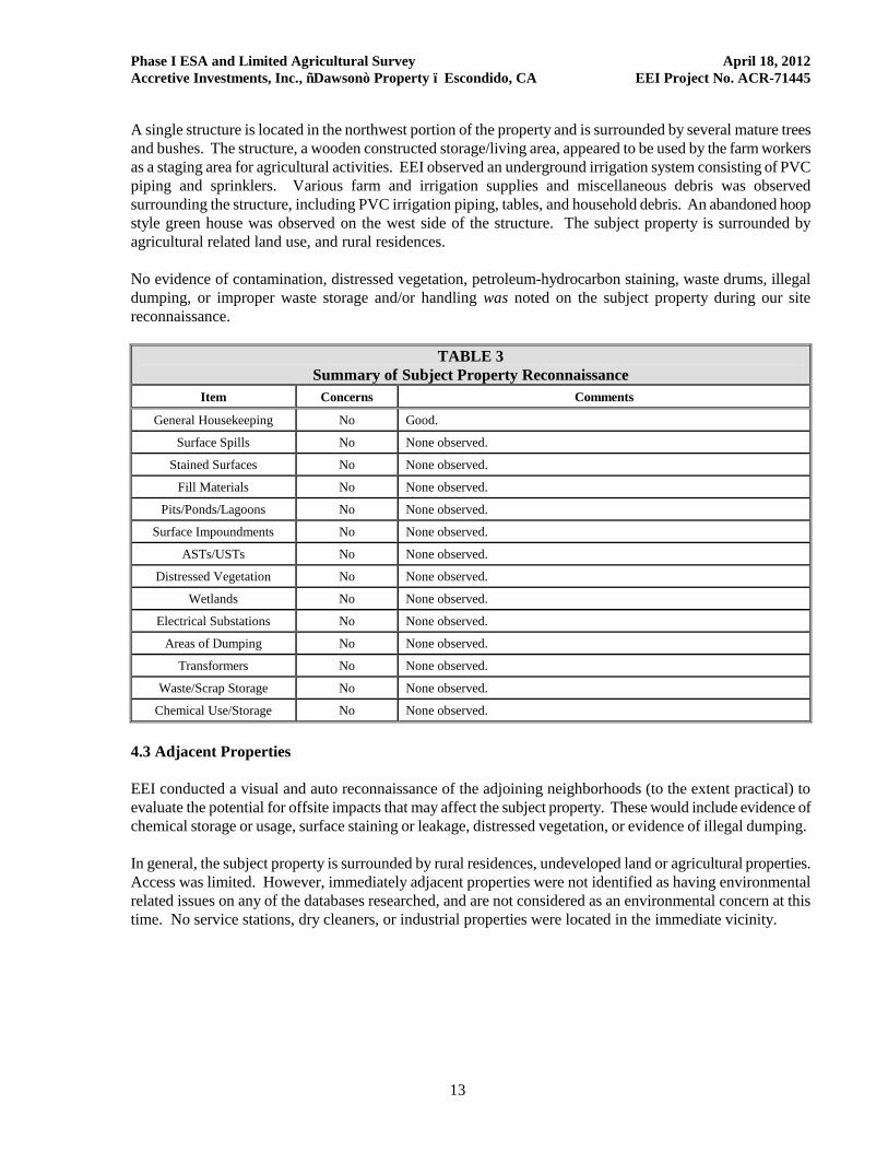
Phase I ESA and Limited Agricultural Survey April 18, 2012 Accretive Investments, Inc., ñDawsonò Property ï Escondido, CA EEI Project No. ACR-71445
13
A single structure is located in the northwest portion of the property and is surrounded by several mature trees and bushes. The structure, a wooden constructed storage/living area, appeared to be used by the farm workers as a staging area for agricultural activities. EEI observed an underground irrigation system consisting of PVC piping and sprinklers. Various farm and irrigation supplies and miscellaneous debris was observed surrounding the structure, including PVC irrigation piping, tables, and household debris. An abandoned hoop style green house was observed on the west side of the structure. The subject property is surrounded by agricultural related land use, and rural residences. No evidence of contamination, distressed vegetation, petroleum-hydrocarbon staining, waste drums, illegal dumping, or improper waste storage and/or handling was noted on the subject property during our site reconnaissance.
TABLE 3 Summary of Subject Property Reconnaissance
Item Concerns Comments
General Housekeeping No Good. Surface Spills No None observed.
Stained Surfaces No None observed. Fill Materials No None observed.
Pits/Ponds/Lagoons No None observed. Surface Impoundments No None observed.
ASTs/USTs No None observed. Distressed Vegetation No None observed.
Wetlands No None observed. Electrical Substations No None observed.
Areas of Dumping No None observed. Transformers No None observed.
Waste/Scrap Storage No None observed. Chemical Use/Storage No None observed.
4.3 Adjacent Properties EEI conducted a visual and auto reconnaissance of the adjoining neighborhoods (to the extent practical) to evaluate the potential for offsite impacts that may affect the subject property. These would include evidence of chemical storage or usage, surface staining or leakage, distressed vegetation, or evidence of illegal dumping. In general, the subject property is surrounded by rural residences, undeveloped land or agricultural properties. Access was limited. However, immediately adjacent properties were not identified as having environmental related issues on any of the databases researched, and are not considered as an environmental concern at this time. No service stations, dry cleaners, or industrial properties were located in the immediate vicinity.
Phase I ESA and Limited Agricultural Survey April 18, 2012 Accretive Investments, Inc., ñDawsonò Property ï Escondido, CA EEI Project No. ACR-71445
14
5.0 LIMITED AGRICULTURAL CHEMICAL SURVEY The subject property has been and continues to be utilized for agricultural purposes. It is likely that restricted agricultural chemicals were applied to subject property soils, which is a potential REC. Based on the future planned property use (residential), additional investigation efforts (i.e., soil sampling and analysis) were performed by EEI to further evaluate subject property soils for agricultural chemicals. There is no specific guidance regarding the testing and analysis of heavy metals and/or pesticides on soils at residential building sites in San Diego County. Therefore, EEI relied principally on the Department of Toxic Substance Control's (DTSC) August 2008 ñInterim Guidance For Sampling Agricultural Propertiesò, combined with our experience gathered over the last two decades. The DTSC document provides guidance for sampling of former agricultural properties (undisturbed) where pesticides and/or fertilizers were presumably applied uniformly, for agricultural purposes, consistent with normal application practices. The DTSC document was initially prepared for use in evaluating soil at proposed new school sites and existing schools undergoing expansion projects where the property was currently or previously used for agricultural activities, but has been expanded to provide a uniform and streamlined approach for evaluating agricultural properties. Based on the size of the property (12.72-acres), and EEIôs experience at similar sites, a total of twelve (12) discrete soil samples, were collected at near-surface (6-inches below grade) locations on the subject property. The following sections discuss our investigation activities. 5.1 Field Investigation On March 16, 2012, EEI personnel mobilized to the subject property to conduct soil sampling activities with a shovel. Soil sampling locations were selected with the goal of collecting representative soil samples from the subject property. A total of twelve discrete locations (identified as ACR-1 through ACR-12, Figure 3) were chosen to provide representative coverage. Samples were collected approximately 6- inches below ground surface (bgs), using a shovel. Sample material was extracted from the ground and placed in laboratory-supplied, 4-ounce glass jars. The jar was sealed with a Teflon-lined cap, and labeled with a number unique to the sample. The samples were placed in a chilled cooler and subsequently picked up by SunStar Labs, a California State-certified laboratory, under proper Chain-of-Custody (COC) documentation. 5.2 Laboratory Analytical Testing All 12 discrete soil samples (ACR-1 through ACR-12) collected during this investigation were analyzed for Arsenic and Lead by United States Environmental Protection Agency (U.S. EPA) Test Method 6010B. Additionally, EEI instructed the laboratory, per DTSC guidelines, to create a total of four (4) composite samples (identified as Composite #1 through Composite #4) from the discrete samples at a ratio of 3:1. All four (4) composite samples (Composite #1 through Composite #4) were analyzed for Organochlorine Pesticides by U.S. EPA Test Method 8081A. The following bulleted items summarize the results of laboratory analytical testing:
No concentrations of arsenic or organochlorine pesticides were detected above the laboratory reporting limit (i.e., ñnon-detect) in any of the samples analyzed.
Lead was reported in samples ACR-3 at 4.9 milligrams per kilogram (mg/kg) and ACR-10 at 4.3 mg/kg. No other samples reported lead above the laboratory reporting limit (i.e., ñnon-detectò).
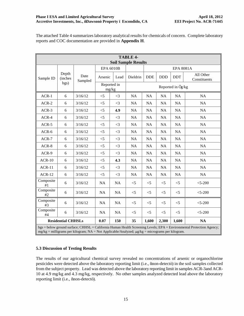
Phase I ESA and Limited Agricultural Survey April 18, 2012 Accretive Investments, Inc., ñDawsonò Property ï Escondido, CA EEI Project No. ACR-71445
15
The attached Table 4 summarizes laboratory analytical results for chemicals of concern. Complete laboratory reports and COC documentation are provided in Appendix H.
TABLE 4- Soil Sample Results
Sample ID Depth (inches bgs)
Date Sampled
EPA 6010B EPA 8081A
Arsenic Lead Dieldrin DDE DDD DDT All Other Constituents
Reported in mg/kg Reported in Õg/kg
ACR-1 6 3/16/12 <5 <3 NA NA NA NA NA ACR-2 6 3/16/12 <5 <3 NA NA NA NA NA ACR-3 6 3/16/12 <5 4.9 NA NA NA NA NA ACR-4 6 3/16/12 <5 <3 NA NA NA NA NA ACR-5 6 3/16/12 <5 <3 NA NA NA NA NA ACR-6 6 3/16/12 <5 <3 NA NA NA NA NA ACR-7 6 3/16/12 <5 <3 NA NA NA NA NA ACR-8 6 3/16/12 <5 <3 NA NA NA NA NA ACR-9 6 3/16/12 <5 <3 NA NA NA NA NA ACR-10 6 3/16/12 <5 4.3 NA NA NA NA NA ACR-11 6 3/16/12 <5 <3 NA NA NA NA NA ACR-12 6 3/16/12 <5 <3 NA NA NA NA NA Composite
#1 6 3/16/12 NA NA <5 <5 <5 <5 <5-200
Composite #2 6 3/16/12 NA NA <5 <5 <5 <5 <5-200
Composite #3 6 3/16/12 NA NA <5 <5 <5 <5 <5-200
Composite #4 6 3/16/12 NA NA <5 <5 <5 <5 <5-200
Residential CHHSLs 0.07 150 35 1,600 2,300 1,600 NA bgs = below ground surface; CHHSL = California Human Health Screening Levels; EPA = Environmental Protection Agency; mg/kg = milligrams per kilogram; NA = Not Applicable/Analyzed; µg/kg = micrograms per kilogram.
5.3 Discussion of Testing Results The results of our agricultural chemical survey revealed no concentrations of arsenic or organochlorine pesticides were detected above the laboratory reporting limit (i.e., ñnon-detectò) in the soil samples collected from the subject property. Lead was detected above the laboratory reporting limit in samples ACR-3and ACR-10 at 4.9 mg/kg and 4.3 mg/kg, respectively. No other samples analyzed detected lead above the laboratory reporting limit (i.e., ñnon-detectò).
Phase I ESA and Limited Agricultural Survey April 18, 2012 Accretive Investments, Inc., ñDawsonò Property ï Escondido, CA EEI Project No. ACR-71445
16
EEI compared the reported lead concentrations to the California Human Health Screening Levels (CHHSL) for a residential land use scenario. The CHHSLs are concentrations of select hazardous chemicals that are used to estimate and compare reported values in soil to risk to human health. The following bulleted items summarize the reported values:
The reported lead concentrations of 4.9 mg/kg and 4.3 mg/kg in soil samples collected during this investigation are less than the CHHSL residential screening level of 150 mg/kg. Furthermore, the lead concentrations appear to represent background levels inherent to the site vicinity. Trace or background levels for soils within central and southwestern San Diego County range from 15.6 mg/kg to 57.1 mg/kg (Kearney Foundation Special Report, 1996).
6.0 FINDINGS AND OPINIONS Based on the information obtained in this ESA, EEI has the following findings and opinions:
Known or suspected RECs ï The following known or suspected RECs have been identified during the preparation of this ESA:
The subject property has been and continues to be utilized for agricultural purposes. Based on
the future planned property use (residential), additional investigation efforts (i.e., soil sampling and analysis) were performed by EEI to further evaluate subject property soils for agricultural chemicals. The results of our agricultural chemical survey revealed no detectable concentrations of arsenic or organochlorine pesticides in the 12 soil samples collected from the subject property. Concentrations of lead were detected in two of the twelve soil samples collected during this investigation; however, the levels were less than applicable residential screening values. Therefore, further investigation does not appear to be warranted at this time.
Historical RECôs ï No historical RECôs have been revealed during the preparation of this ESA. De Minimis Conditions ï No de minimis conditions have been revealed during the preparation of this
ESA. 7.0 DATA GAPS AND DEVIATIONS FROM ASTM PRACTICES Section 3.2.20 (ASTM 1527-05) defines a data gap as ña lack or inability to obtain information required by the practice despite good faith efforts of the environmental professional to gather such information.ò 7.1 Historical Data Gaps No historical data gaps were identified during our research efforts. 7.2 Regulatory Data Gaps No regulatory data gaps were identified during our research efforts.
Phase I ESA and Limited Agricultural Survey April 18, 2012 Accretive Investments, Inc., ñDawsonò Property ï Escondido, CA EEI Project No. ACR-71445
17
7.3 On-site Data Gaps No on-site data gaps were identified during our research efforts. 7.4 Deviations from ASTM Practices Section 12.10 (ASTM 1527-05), states that all deletions and deviations from this practice shall be listed individually and in detail, including client imposed constraints, and all additions should be listed. Accordingly, EEI believes that there are no exceptions to, or deletions from, the ASTM Designation E1527-05 Guidelines. 8.0 CONCLUSIONS We have performed a Phase I Environmental Site Assessment (ESA) in conformance with the scope and limitations of ASTM Designation E1527-05 for the subject property identified as APNs 129-011-06 and -17, and located northwest of Rodriguez Road and Nelson Way, Escondido, California. Any exceptions to, or deletions from, this practice are described in Section 7.0 of this report. Phase I ESA has revealed no evidence of recognized environmental conditions in connection with the property. In addition EEI has the following comment:
Based on the subject propertyôs historical agricultural use, it is possible that buried/concealed/hidden
agricultural by-products, both below and above ground may have existed or exists on the subject property. Any buried trash/debris, or other waste encountered during future subject property development should be evaluated by an experienced environmental consultant prior to removal. If stained or suspicious soil is encountered during future grading operations, the material should be evaluated and if deemed necessary, characterized for proper disposal.
Phase I ESA and Limited Agricultural Survey April 18, 2012 Accretive Investments, Inc., ñDawsonò Property ï Escondido, CA EEI Project No. ACR-71445
18
9.0 REFERENCES California Department of Water Resources, Water Data Library (WDL), Website (http://www.water.ca.gov/waterdatalibrary), accessed March 2012. California Division of Oil, Gas, and Geothermal Resources (CDOGGR) Website (http://maps.conservation.ca.gov/doms/index.html), accessed March 2012. California Environmental Protection Agency (CalEPA), 2005, ñUse of California Human Health Screening Levels (CHHSLs) in Evaluation of Contaminated Properties.ò California Geological Survey (CGS), 2002, ñCalifornia Geomorphic Provinces, Note 36.ò County of San Diego Land Use and Environmental Group (LUEG), KIVA, Website (http://landinfo.sdcounty.ca.gov/permit/index.cfm), accessed March 2012. Department of Toxic Substances (DTSC), Website (http://www.envirostor.dtsc.ca.gov/public/), EnviroStor database, accessed March 2012. Department of Toxic Substances Control (DTSC), 2008, ñInterim Guidance for Sampling Agricultural Properties (Third Revision).ò Federal Emergency Management Act (FEMA), Flood Insurance Rate Map (FIRM), Website http://msc.fema.gov/webapp/wcs/stores/servlet/FemaWelcomeView?storeId=10001&catalogId=10001&langId=-1 accessed March 2012. Kearny Foundation Special Report, ñBackground Concentrations of Trace and Major Elements in California Soils,ò UC Riverside, 1996. Los Angeles County Public Library (LAPL), Sanborn Maps 1867-1970, Website http://databases.lapl.org/#s, accessed March 2012. National Pipeline Mapping System (NPMS), Public Map Viewer Website, (https://www.npms.phmsa.dot.gov/PublicViewer/), accessed March 2012. San Diego Geographic Information Source, (SanGIS), Website, (http://files.sangis.org/interactive/viewer/viewer.asp), accessed March 2012. San Diego Regional Water Quality Control Board (SDRWQCB), 1994, ñWater Quality Control Plan for the San Diego Basin (9),ò dated September 8. State Water Resources Control Board, Website, GeoTracker database, (http://www.geotracker.swrcb.ca.gov/), accessed March 2012. United Nations Environmental Programme, 1999, Guidelines for the Identification of PCBs and Materials Containing PCBs. United States Department of Agriculture (USDA), Natural Resources Conservation Service, Website (http://websoilsurvey.nrcs.usda.gov/app/) Web Soil Survey, accessed March 2012. United States Geological Survey (USGS) 1997, Pala, 7.5-Minute Quadrangle.
Phase I ESA and Limited Agricultural Survey April 18, 2012 Accretive Investments, Inc., ñDawsonò Property ï Escondido, CA EEI Project No. ACR-71445
FIGURES
Note All Locations Are Approximate
FIGURE 1
SITE LOCATION MAPACCRETIVE INVESTMENTS, INC.
12.27-Acre “Dawson” Property APNs 129-011-16 and 129-011-17
Escondido, California 92026EEI Project Number ACR-71445
Created March 2012
Map Source: Google Maps®, Accessed, March 2012
0
Scale: 1" = 1,250'1,250 FT 2,500 FT750 FT
SUBJECT PROPERTY LOCATION
Note All Locations Are Approximate
FIGURE 2
AERIAL SITE MAPACCRETIVE INVESTMENTS, INC.
12.27-Acre “Dawson” Property APN 129-011-16 and 129-011-17
Escondido, California 92026EEI Project No. ACR-71344
Created March 2012
Map Source: Accretive Investments, Inc., March 2012
0
Scale: 1" = 200'200 FT 400 FT120 FT
SUBJECT PROPERTY BOUNDARY
RO
DR
IGU
EZ
RO
AD
Note All Locations Are Approximate
FIGURE 3
SOIL BORING LOCATION MAPACCRETIVE INVESTMENTS, INC.
12.27-Acre “Dawson” Property APN 129-011-16 and 129-011-17
Escondido, California 92026EEI Project No. ACR-71344
Created March 2012
Map Source: Accretive Investments, Inc., March 2012
0
Scale: 1" = 200'200 FT 400 FT120 FT
LEGEND
SUBJECT PROPERTY BOUNDARY
RO
DR
IGU
EZ
RO
AD
EEI Soil Boring LocationACR-1
ACR-1
ACR-2
ACR-8
ACR-5
ACR-6 ACR-3
ACR-4
ACR-9
ACR-10 ACR-7
ACR-12
ACR-11
Phase I ESA and Limited Agricultural Survey April 18, 2012 Accretive Investments, Inc., ñDawsonò Property ï Escondido, CA EEI Project No. ACR-71445
APPENDIX A RESUME OF ENVIRONMENTAL PROFESSIONAL
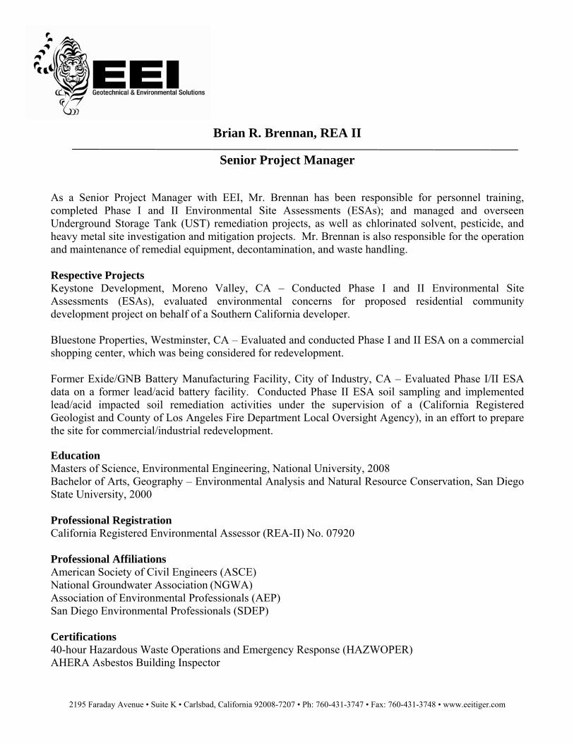
2195 Faraday Avenue • Suite K • Carlsbad, California 92008-7207 • Ph: 760-431-3747 • Fax: 760-431-3748 • www.eeitiger.com
Brian R. Brennan, REA II
Senior Project Manager As a Senior Project Manager with EEI, Mr. Brennan has been responsible for personnel training, completed Phase I and II Environmental Site Assessments (ESAs); and managed and overseen Underground Storage Tank (UST) remediation projects, as well as chlorinated solvent, pesticide, and heavy metal site investigation and mitigation projects. Mr. Brennan is also responsible for the operation and maintenance of remedial equipment, decontamination, and waste handling. Respective Projects Keystone Development, Moreno Valley, CA – Conducted Phase I and II Environmental Site Assessments (ESAs), evaluated environmental concerns for proposed residential community development project on behalf of a Southern California developer. Bluestone Properties, Westminster, CA – Evaluated and conducted Phase I and II ESA on a commercial shopping center, which was being considered for redevelopment. Former Exide/GNB Battery Manufacturing Facility, City of Industry, CA – Evaluated Phase I/II ESA data on a former lead/acid battery facility. Conducted Phase II ESA soil sampling and implemented lead/acid impacted soil remediation activities under the supervision of a (California Registered Geologist and County of Los Angeles Fire Department Local Oversight Agency), in an effort to prepare the site for commercial/industrial redevelopment. Education Masters of Science, Environmental Engineering, National University, 2008 Bachelor of Arts, Geography – Environmental Analysis and Natural Resource Conservation, San Diego State University, 2000 Professional Registration California Registered Environmental Assessor (REA-II) No. 07920 Professional Affiliations American Society of Civil Engineers (ASCE) National Groundwater Association (NGWA) Association of Environmental Professionals (AEP) San Diego Environmental Professionals (SDEP) Certifications 40-hour Hazardous Waste Operations and Emergency Response (HAZWOPER) AHERA Asbestos Building Inspector
Phase I ESA and Limited Agricultural Survey April 18, 2012 Accretive Investments, Inc., ñDawsonò Property ï Escondido, CA EEI Project No. ACR-71445
APPENDIX B SAN DIEGO COUNTY ASSESSORôS PARCEL MAP
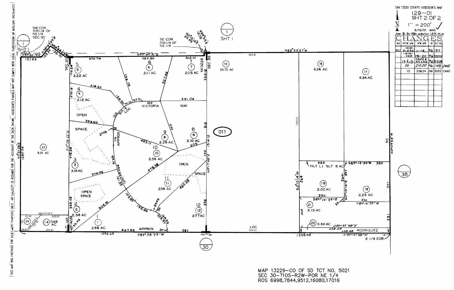
Phase I ESA and Limited Agricultural Survey April 18, 2012 Accretive Investments, Inc., ñDawsonò Property ï Escondido, CA EEI Project No. ACR-71445
APPENDIX C HISTORICAL AERIAL PHOTOGRAPHS/TOPOGRAPHIC MAPS
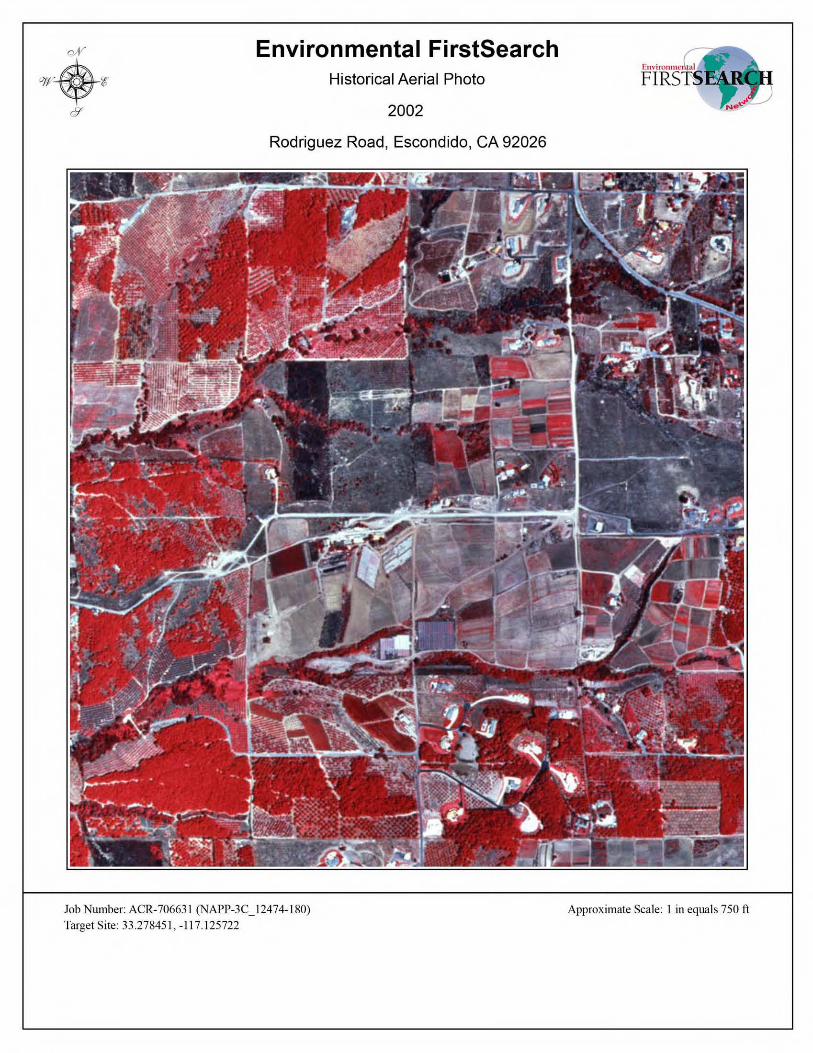
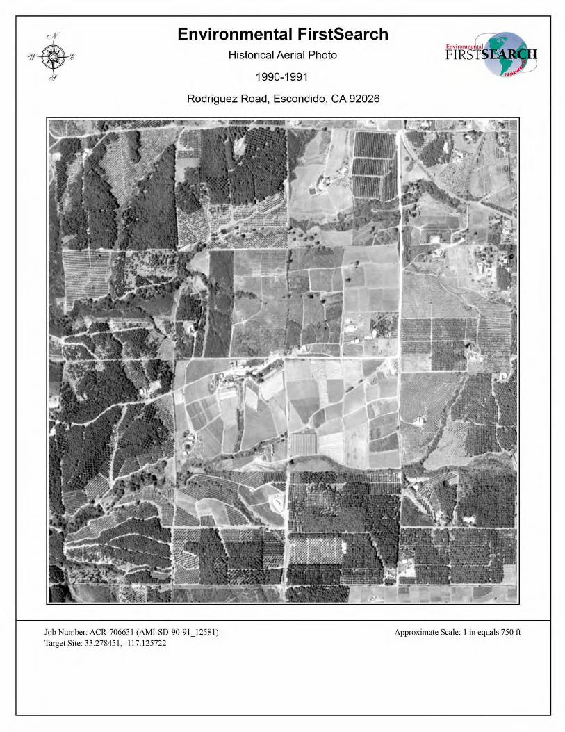
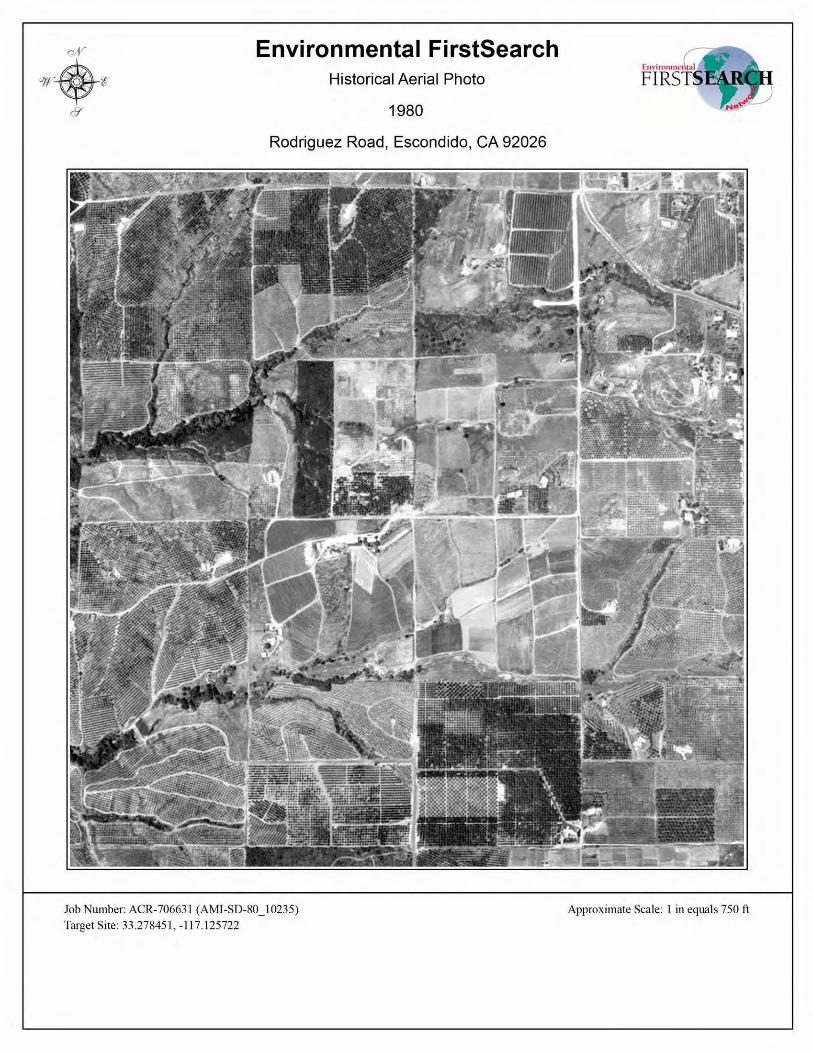
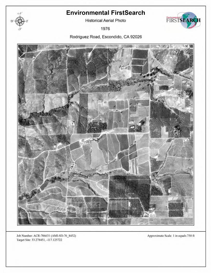
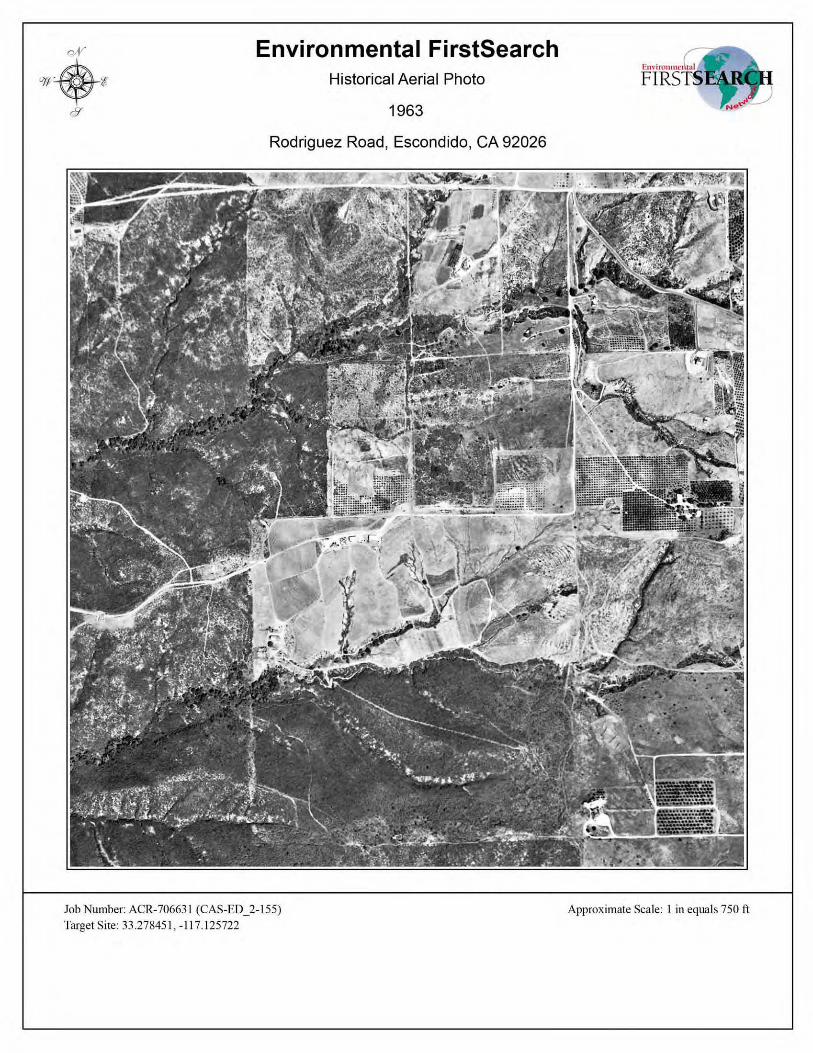
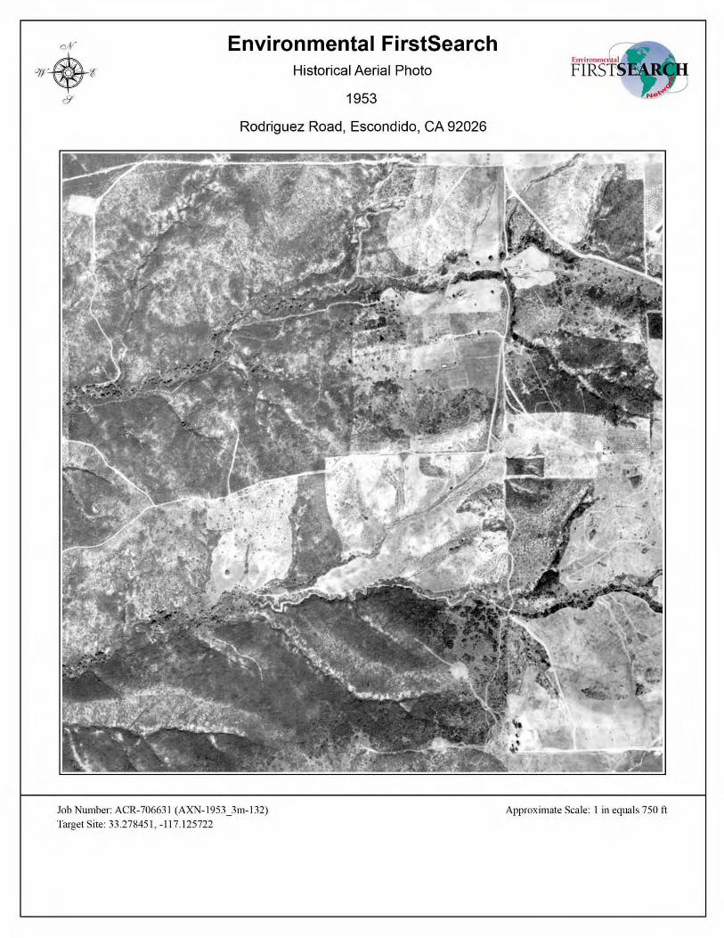
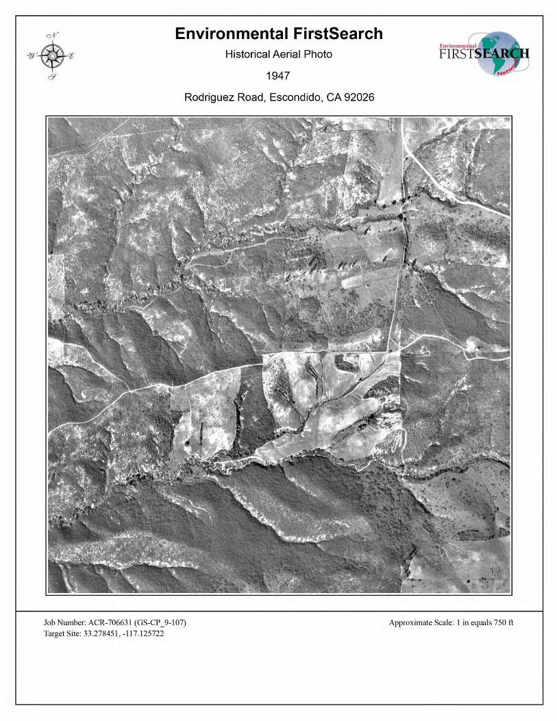
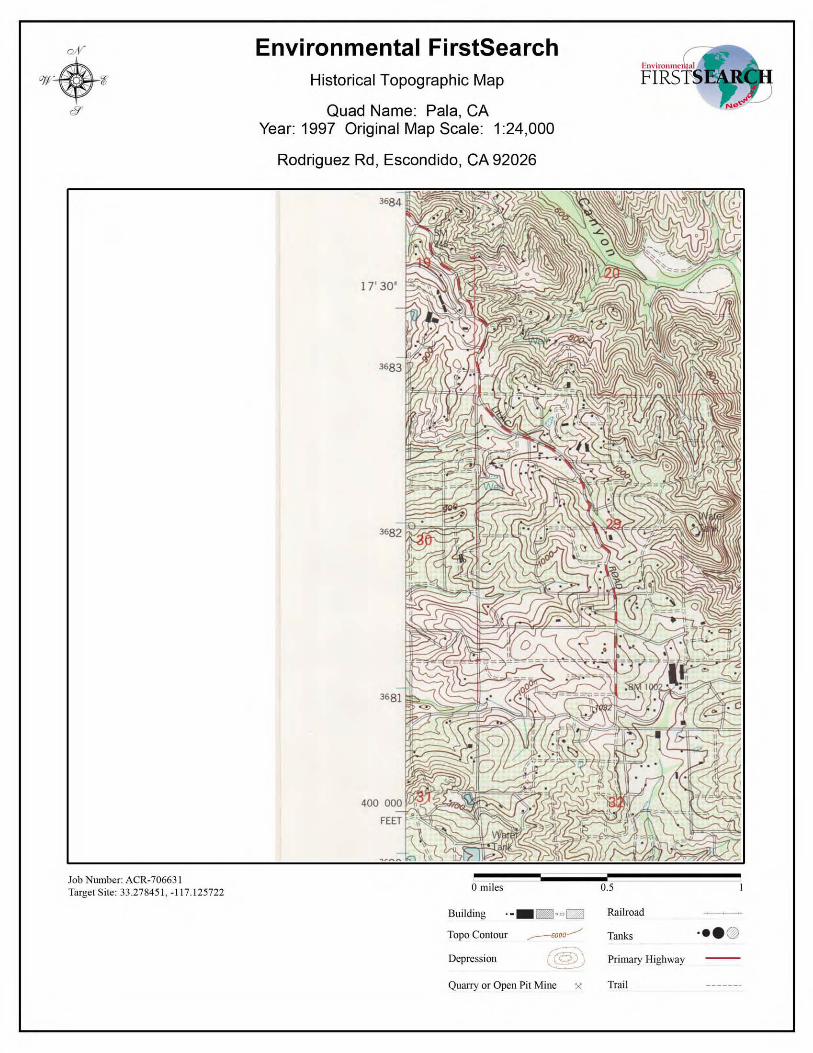
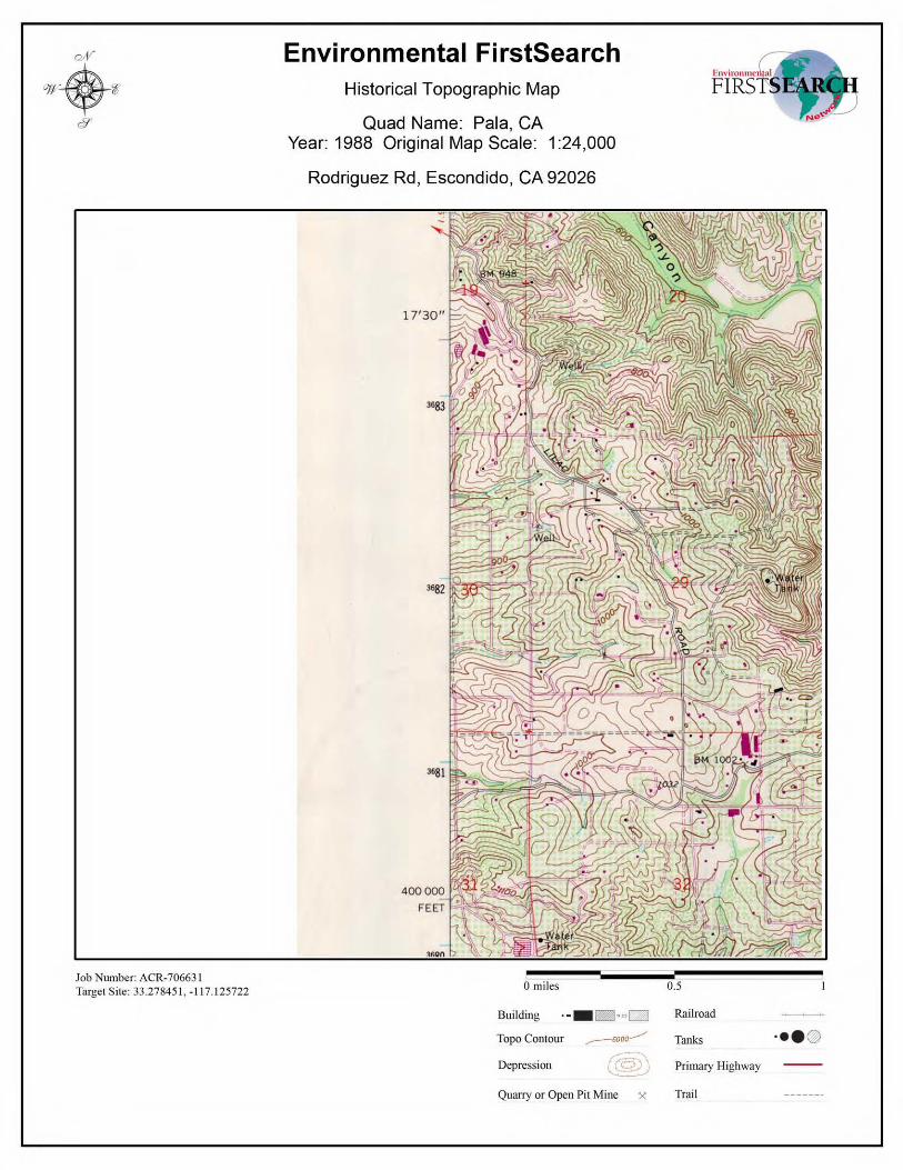
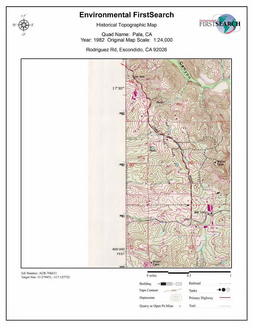
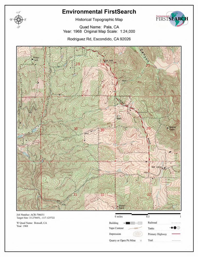
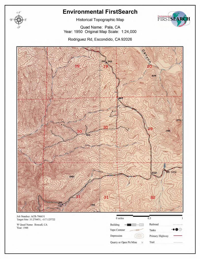
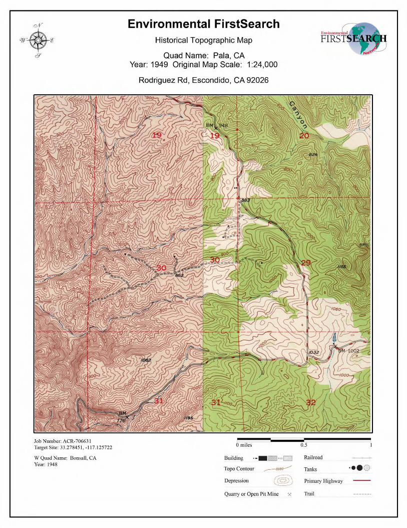
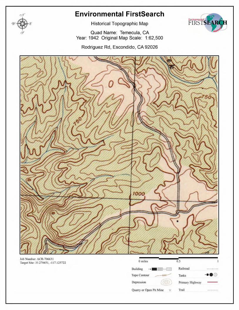
Phase I ESA and Limited Agricultural Survey April 18, 2012 Accretive Investments, Inc., ñDawsonò Property ï Escondido, CA EEI Project No. ACR-71445
APPENDIX D ENVIRONMENTAL RECORDS SEARCH
FirstSearch Technology Corporation
TM
Environmental FirstSearch Report
Target Property:
RODRIGUEZ RD
ESCONDIDO CA 92026
Job Number: ACR_71445
PREPARED FOR:
EEI, Inc.
2195 Faraday Avenue, Suite K
Carlsbad, CA 92008
760.431.3747
03-14-12
Tel: (781) 551-0470 Fax: (781) 551-0471
Environmental FirstSearch is a registered trademark of FirstSearch Technology Corporation. All rights reserved.
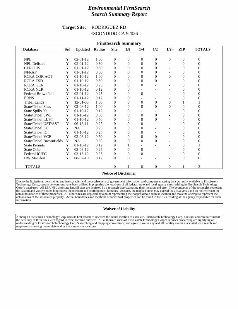
Environmental FirstSearchSearch Summary Report
Target Site: RODRIGUEZ RDESCONDIDO CA 92026
FirstSearch Summary
Notice of Disclaimer
Waiver of Liability
Database Sel Updated Radius Site 1/8 1/4 1/2 1/2> ZIP TOTALS
NPL Y 02-01-12 1.00 0 0 0 0 0 0 0NPL Delisted Y 02-01-12 0.50 0 0 0 0 - 0 0CERCLIS Y 01-01-12 0.50 0 0 0 0 - 0 0NFRAP Y 01-01-12 0.50 0 0 0 0 - 0 0RCRA COR ACT Y 01-10-12 1.00 0 0 0 0 0 0 0RCRA TSD Y 01-10-12 0.50 0 0 0 0 - 0 0RCRA GEN Y 01-10-12 0.25 0 0 0 - - 0 0RCRA NLR Y 01-10-12 0.12 0 0 - - - 0 0Federal Brownfield Y 02-01-12 0.25 0 0 0 - - 0 0ERNS Y 01-11-12 0.12 0 0 - - - 0 0Tribal Lands Y 12-01-05 1.00 0 0 0 0 0 1 1State/Tribal Sites Y 02-08-12 1.00 0 0 0 0 0 0 0State Spills 90 Y 01-10-12 0.12 0 0 - - - 0 0State/Tribal SWL Y 01-10-12 0.50 0 0 0 0 - 0 0State/Tribal LUST Y 01-10-12 0.50 0 0 0 0 - 0 0State/Tribal UST/AST Y 06-13-11 0.25 0 0 0 - - 0 0State/Tribal EC Y NA 0.25 0 0 0 - - 0 0State/Tribal IC Y 01-18-12 0.25 0 0 0 - - 0 0State/Tribal VCP Y 02-08-12 0.50 0 0 0 0 - 0 0State/Tribal Brownfields Y NA 0.50 0 0 0 0 - 0 0State Permits Y 01-10-12 0.12 0 1 - - - 0 1State Other Y 02-08-12 0.25 0 0 0 - - 0 0Federal IC/EC Y 03-13-12 0.25 0 0 0 - - 0 0HW Manifest Y 08-02-10 0.12 0 0 - - - 0 0
-TOTALS- 0 1 0 0 0 1 2
Due to the limitations, constraints, and inaccuracies and incompleteness of government information and computer mapping data currently available to FirstSearchTechnology Corp., certain conventions have been utilized in preparing the locations of all federal, state and local agency sites residing in FirstSearch TechnologyCorp.'s databases. All EPA NPL and state landfill sites are depicted by a rectangle approximating their location and size. The boundaries of the rectangles representthe eastern and western most longitudes; the northern and southern most latitudes. As such, the mapped areas may exceed the actual areas and do not represent theactual boundaries of these properties. All other sites are depicted by a point representing their approximate address location and make no attempt to represent theactual areas of the associated property. Actual boundaries and locations of individual properties can be found in the files residing at the agency responsible for suchinformation.
Although FirstSearch Technology Corp. uses its best efforts to research the actual location of each site, FirstSearch Technology Corp. does not and can not warrantthe accuracy of these sites with regard to exact location and size. All authorized users of FirstSearch Technology Corp.'s services proceeding are signifying anunderstanding of FirstSeaarch Technology Corp.'s searching and mapping conventions, and agree to waive any and all liability claims associated with search andmap results showing incomplete and or inaccurate site locations.
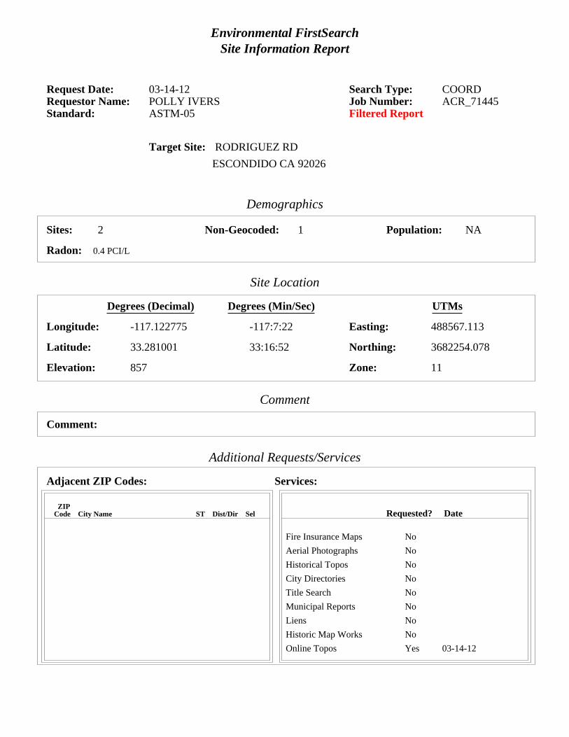
Environmental FirstSearchSite Information Report
Request Date: 03-14-12 Search Type: COORDRequestor Name: POLLY IVERS Job Number: ACR_71445Standard: ASTM-05 Filtered Report
Target Site: RODRIGUEZ RD
ESCONDIDO CA 92026
Demographics
Sites: 2 Non-Geocoded: 1 Population: NA
Radon: 0.4 PCI/L
Site Location
Degrees (Decimal) Degrees (Min/Sec) UTMs
Longitude: -117.122775 -117:7:22 Easting: 488567.113
Latitude: 33.281001 33:16:52 Northing: 3682254.078
Elevation: 857 Zone: 11
Comment
Comment:
Additional Requests/Services
Adjacent ZIP Codes: Services:
ZIPCode City Name ST Dist/Dir Sel Requested? Date
Fire Insurance Maps No
Aerial Photographs No
Historical Topos No
City Directories No
Title Search No
Municipal Reports No
Liens No
Historic Map Works No
Online Topos Yes 03-14-12
Environmental FirstSearchTarget Site Summary Report
Target Property: RODRIGUEZ RD JOB: ACR_71445ESCONDIDO CA 92026
TOTAL: 2 GEOCODED: 1 NON GEOCODED: 1 SELECTED: 0
No sites found for target address
Map ID DB Type Site Name/ID/Status Address Dist/Dir ElevDiff Page No.
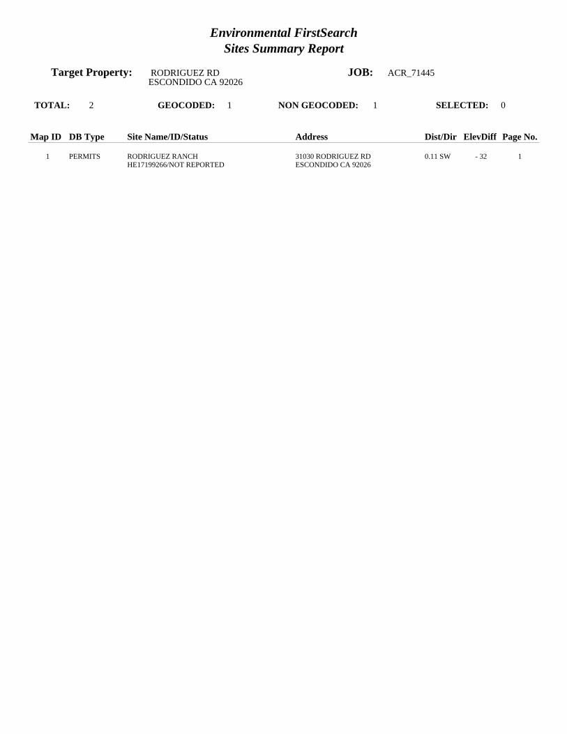
Environmental FirstSearchSites Summary Report
Target Property: RODRIGUEZ RD JOB: ACR_71445ESCONDIDO CA 92026
TOTAL: 2 GEOCODED: 1 NON GEOCODED: 1 SELECTED: 0
Map ID DB Type Site Name/ID/Status Address Dist/Dir ElevDiff Page No.
1 PERMITS RODRIGUEZ RANCH 31030 RODRIGUEZ RD 0.11 SW - 32 1HE17199266/NOT REPORTED ESCONDIDO CA 92026
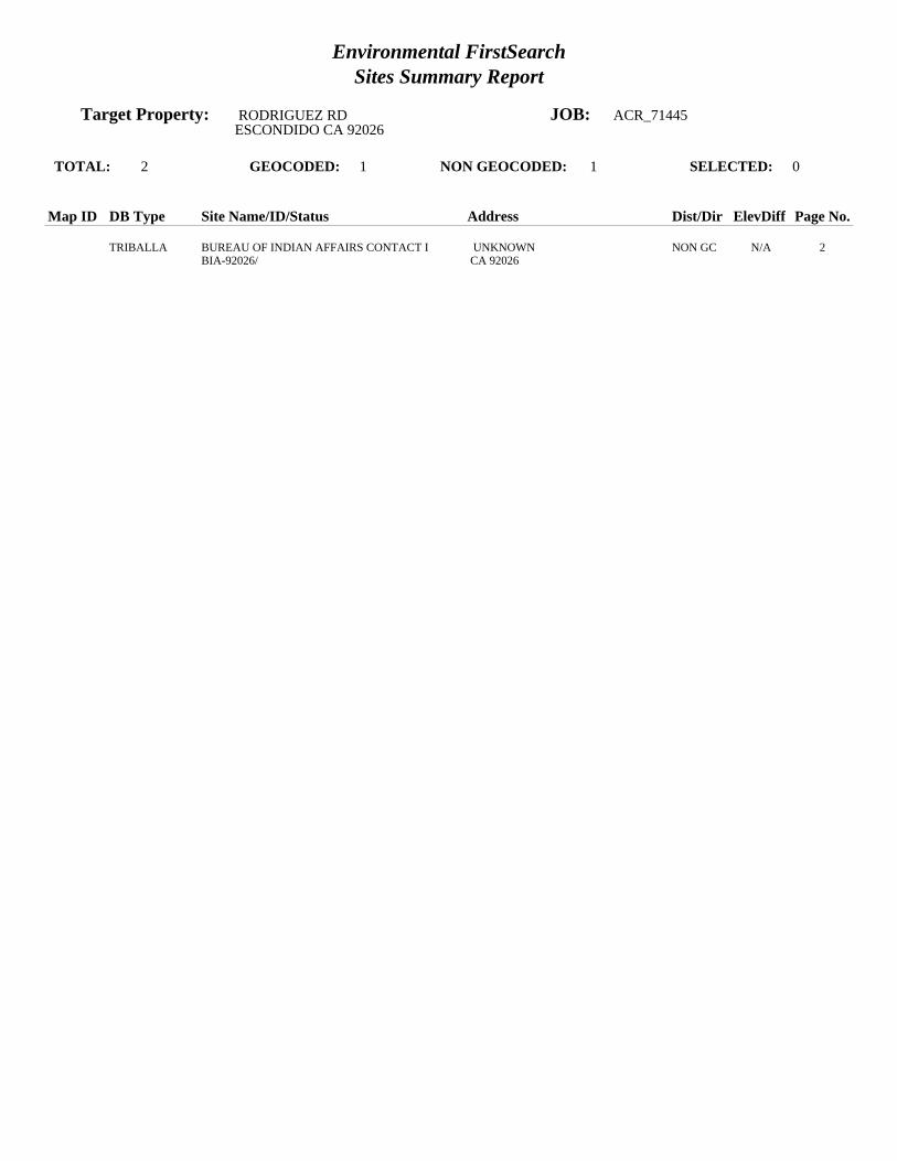
Environmental FirstSearchSites Summary Report
Target Property: RODRIGUEZ RD JOB: ACR_71445ESCONDIDO CA 92026
TOTAL: 2 GEOCODED: 1 NON GEOCODED: 1 SELECTED: 0
Map ID DB Type Site Name/ID/Status Address Dist/Dir ElevDiff Page No.
TRIBALLA BUREAU OF INDIAN AFFAIRS CONTACT I UNKNOWN NON GC N/A 2BIA-92026/ CA 92026
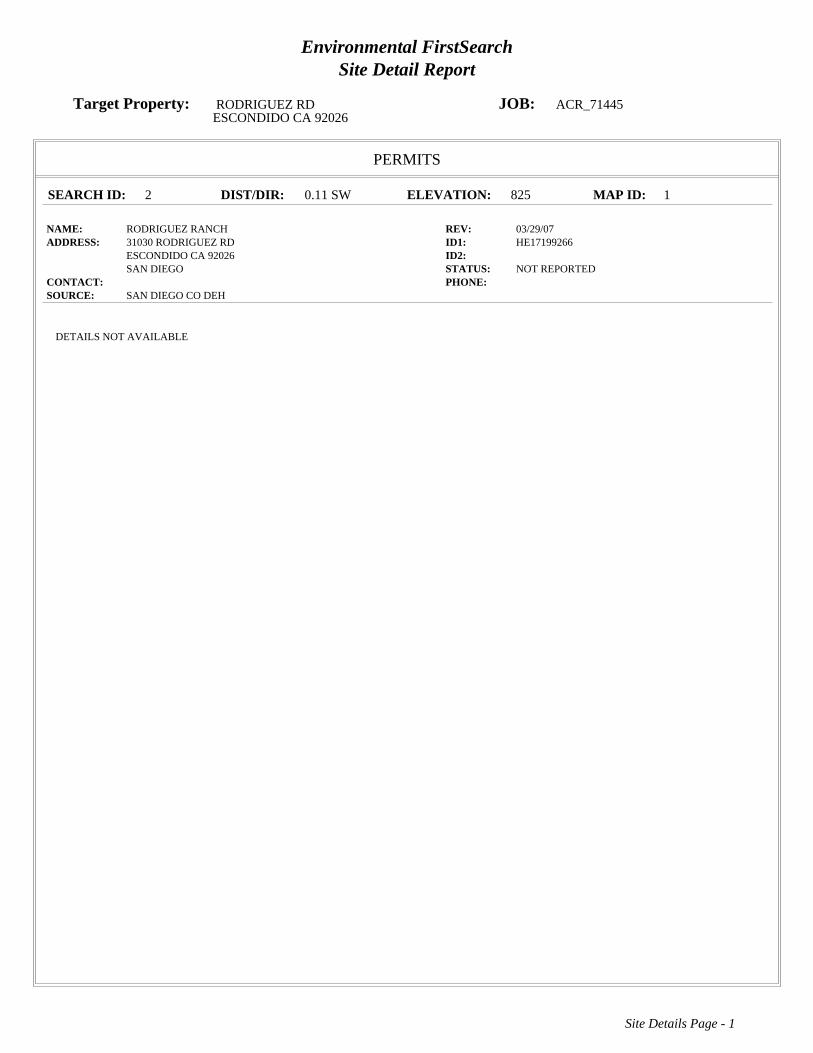
Environmental FirstSearchSite Detail Report
Target Property: RODRIGUEZ RD JOB: ACR_71445ESCONDIDO CA 92026
PERMITS
SEARCH ID: 2 DIST/DIR: 0.11 SW ELEVATION: 825 MAP ID: 1
NAME: RODRIGUEZ RANCH REV: 03/29/07ADDRESS: 31030 RODRIGUEZ RD ID1: HE17199266
ESCONDIDO CA 92026 ID2: SAN DIEGO STATUS: NOT REPORTED
CONTACT: PHONE: SOURCE: SAN DIEGO CO DEH
Site Details Page - 1
DETAILS NOT AVAILABLE

Environmental FirstSearchSite Detail Report
Target Property: RODRIGUEZ RD JOB: ACR_71445ESCONDIDO CA 92026
TRIBALLAND
SEARCH ID: 1 DIST/DIR: NON GC ELEVATION: MAP ID:
NAME: BUREAU OF INDIAN AFFAIRS CONTACT INFORMATION REV: 01/15/08ADDRESS: UNKNOWN ID1: BIA-92026
CA 92026 ID2: SAN DIEGO STATUS:
CONTACT: PHONE: SOURCE: BIA
Site Details Page - 2
BUREAU OF INDIAN AFFAIRS CONTACT INFORMATION
OFFICE: Pacific Regional OfficeCONTACT: CLAY GREGORY,REGIONAL DIRECTOR
OFFICE ADDRESS: 2800 Cottage WaySacramento CA 95825OFFICE PHONE: Phone: 916-978-6000OFFICE FAX: Fax: 916-978-6099
The Native American Consultation Database (NACD) is a tool for identifying consultation contacts for Indian tribes, Alaska Native villages and corporations, andNative Hawaiian organizations. The database is not a comprehensive source of information, but it does provide a starting point for the consultation process byidentifying tribal leaders and NAGPRA contacts. This database can be accessed online at the following web address http://home.nps.gov/nacd/
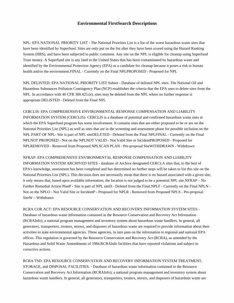
Environmental FirstSearch Descriptions
NPL: EPA NATIONAL PRIORITY LIST - The National Priorities List is a list of the worst hazardous waste sites that
have been identified by Superfund. Sites are only put on the list after they have been scored using the Hazard Ranking
System (HRS), and have been subjected to public comment. Any site on the NPL is eligible for cleanup using Superfund
Trust money. A Superfund site is any land in the United States that has been contaminated by hazardous waste and
identified by the Environmental Protection Agency (EPA) as a candidate for cleanup because it poses a risk to human
health and/or the environment.FINAL - Currently on the Final NPLPROPOSED - Proposed for NPL
NPL DELISTED: EPA NATIONAL PRIORITY LIST Subset - Database of delisted NPL sites. The National Oil and
Hazardous Substances Pollution Contingency Plan (NCP) establishes the criteria that the EPA uses to delete sites from the
NPL. In accordance with 40 CFR 300.425.(e), sites may be deleted from the NPL where no further response is
appropriate.DELISTED - Deleted from the Final NPL
CERCLIS: EPA COMPREHENSIVE ENVIRONMENTAL RESPONSE COMPENSATION AND LIABILITY
INFORMATION SYSTEM (CERCLIS)- CERCLIS is a database of potential and confirmed hazardous waste sites at
which the EPA Superfund program has some involvement. It contains sites that are either proposed to be or are on the
National Priorities List (NPL) as well as sites that are in the screening and assessment phase for possible inclusion on the
NPL.PART OF NPL- Site is part of NPL siteDELETED - Deleted from the Final NPLFINAL - Currently on the Final
NPLNOT PROPOSED - Not on the NPLNOT VALID - Not Valid Site or IncidentPROPOSED - Proposed for
NPLREMOVED - Removed from Proposed NPLSCAN PLAN - Pre-proposal SiteWITHDRAWN - Withdrawn
NFRAP: EPA COMPREHENSIVE ENVIRONMENTAL RESPONSE COMPENSATION AND LIABILITY
INFORMATION SYSTEM ARCHIVED SITES - database of Archive designated CERCLA sites that, to the best of
EPA's knowledge, assessment has been completed and has determined no further steps will be taken to list this site on the
National Priorities List (NPL). This decision does not necessarily mean that there is no hazard associated with a given site;
it only means that, based upon available information, the location is not judged to be a potential NPL site.NFRAP – No
Further Remedial Action PlanP - Site is part of NPL siteD - Deleted from the Final NPLF - Currently on the Final NPLN -
Not on the NPLO - Not Valid Site or IncidentP - Proposed for NPLR - Removed from Proposed NPLS - Pre-proposal
SiteW – Withdrawn
RCRA COR ACT: EPA RESOURCE CONSERVATION AND RECOVERY INFORMATION SYSTEM SITES -
Database of hazardous waste information contained in the Resource Conservation and Recovery Act Information
(RCRAInfo), a national program management and inventory system about hazardous waste handlers. In general, all
generators, transporters, treaters, storers, and disposers of hazardous waste are required to provide information about their
activities to state environmental agencies. These agencies, in turn pass on the information to regional and national EPA
offices. This regulation is governed by the Resource Conservation and Recovery Act (RCRA), as amended by the
Hazardous and Solid Waste Amendments of 1984.RCRAInfo facilities that have reported violations and subject to
corrective actions.
RCRA TSD: EPA RESOURCE CONSERVATION AND RECOVERY INFORMATION SYSTEM TREATMENT,
STORAGE, and DISPOSAL FACILITIES. - Database of hazardous waste information contained in the Resource
Conservation and Recovery Act Information (RCRAInfo), a national program management and inventory system about
hazardous waste handlers. In general, all generators, transporters, treaters, storers, and disposers of hazardous waste are
required to provide information about their activities to state environmental agencies. These agencies, in turn pass on the
information to regional and national EPA offices. This regulation is governed by the Resource Conservation and Recovery
Act (RCRA), as amended by the Hazardous and Solid Waste Amendments of 1984.Facilities that treat, store, dispose, or
incinerate hazardous waste.
RCRA GEN: EPA/MA DEP/CT DEP RESOURCE CONSERVATION AND RECOVERY INFORMATION SYSTEM
GENERATORS - Database of hazardous waste information contained in the Resource Conservation and Recovery Act
Information (RCRAInfo), a national program management and inventory system about hazardous waste handlers. In
general, all generators, transporters, treaters, storers, and disposers of hazardous waste are required to provide information
about their activities to state environmental agencies. These agencies, in turn pass on the information to regional and
national EPA offices. This regulation is governed by the Resource Conservation and Recovery Act (RCRA), as amended
by the Hazardous and Solid Waste Amendments of 1984.Facilities that generate or transport hazardous waste or meet
other RCRA requirements.LGN - Large Quantity GeneratorsSGN - Small Quantity GeneratorsVGN – Conditionally
Exempt Generator.Included are RAATS (RCRA Administrative Action Tracking System) and CMEL (Compliance
Monitoring & Enforcement List) facilities. CONNECTICUT HAZARDOUS WASTE MANIFEST – Database of all
shipments of hazardous waste within, into or from Connecticut. The data includes date of shipment, transporter and TSD
info, and material shipped and quantity. This data is appended to the details of existing generator records.
MASSACHUSETTES HAZARDOUS WASTE GENERATOR – database of generators that are regulated under the MA
DEP. VQN-MA = generates less than 220 pounds or 27 gallons per month of hazardous waste or waste oil.SQN-MA =
generates 220 to 2,200 pounds or 27 to 270 gallons per month of waste oil.LQG-MA = generates greater than 2,200 lbs of
hazardous waste or waste oil per month.
RCRA NLR: EPA RESOURCE CONSERVATION AND RECOVERY INFORMATION SYSTEM SITES - Database of
hazardous waste information contained in the Resource Conservation and Recovery Act Information (RCRAInfo), a
national program management and inventory system about hazardous waste handlers. In general, all generators,
transporters, treaters, storers, and disposers of hazardous waste are required to provide information about their activities to
state environmental agencies. These agencies, in turn pass on the information to regional and national EPA offices. This
regulation is governed by the Resource Conservation and Recovery Act (RCRA), as amended by the Hazardous and Solid
Waste Amendments of 1984.not currently classified by the EPA but are still included in the RCRAInfo database. Reasons
for non classification: Failure to report in a timely matter. No longer in business. No longer in business at the listed
address. No longer generating hazardous waste materials in quantities which require reporting.
Fed Brownfield: EPA BROWNFIELD MANAGEMENT SYSTEM (BMS) - database designed to assist EPA in
collecting, tracking, and updating information, as well as reporting on the major activities and accomplishments of the
various Brownfield grant Programs./n CLEANUPS IN MY COMMUNITY (subset) - Sites, facilities and properties that
have been contaminated by hazardous materials and are being, or have been, cleaned up under EPA's brownfield’s
program.
ERNS: EPA/NRC EMERGENCY RESPONSE NOTIFICATION SYSTEM (ERNS) - Database of incidents reported to
the National Response Center. These incidents include chemical spills, accidents involving chemicals (such as fires or
explosions), oil spills, transportation accidents that involve oil or chemicals, releases of radioactive materials, sightings of
oil sheens on bodies of water, terrorist incidents involving chemicals, incidents where illegally dumped chemicals have
been found, and drills intended to prepare responders to handle these kinds of incidents. Data since January 2001 has been
received from the National Response System database as the EPA no longer maintains this data.
Tribal Lands: DOI/BIA INDIAN LANDS OF THE UNITED STATES - Database of areas with boundaries established by
treaty, statute, and (or) executive or court order, recognized by the Federal Government as territory in which American
Indian tribes have primary governmental authority. The Indian Lands of the United States map layer shows areas of 640
acres or more, administered by the Bureau of Indian Affairs. Included are Federally-administered lands within a
reservation which may or may not be considered part of the reservation.BUREAU OF INDIAN AFFIARS CONTACT -
Regional contact information for the Bureau of Indian Affairs offices.
State/Tribal Sites: CA EPA SMBRPD / CAL SITES- The California Department of Toxic Substances Control (DTSC) has
developed an electronic database system called Envirostor with information about sites that are known to be contaminated
with hazardous substances as well as information on uncharacterized properties where further studies may reveal
problems. The Site Mitigation and Brownfields Reuse Program Database (SMBRPD), formerly known as CalSites, is used
primarily by DTSC’s staff as an informational tool to evaluate and track activities at properties that may have been
affected by the release of hazardous substances. The SMBRPD displays information in six categories, two of which are
found in ST. The categories listed under ST are: 1. State Response Sites. 2. School Property Evaluation Program
Properties (SCH) Please Note: Our reports list the above sites as DB Type (STATE). Other categories found in the
SMBRPD are listed in our reports in the DB Types OT and VC. Each Category contains information on properties based
upon the type of work taking place at the site. State Response Sites contains only known and potential hazardous
substance release sites considered as posing the greatest threat to the public. School sites included in ST will be found
within the SMBRPD's School Property Evaluation Program. CORTESE LIST-Pursuant to Government Code Section
65962.5, the Hazardous Waste and Substances Sites List has been compiled by Cal/EPA, Hazardous Materials Data
Management Program to provide information about the location of hazardous materials release sites. Cortese List sites that
fall under DTSC's guidelines for State Response sites are included in our reports in the ST category as are qualifying sites
from the Annual Work Plan (formerly Bond Expenditure Plan) and the historic ASPIS databases.
State Spills 90: CA EPA SLIC REGIONS 1 - 9- The California Regional Water Quality Control Boards maintain report of
sites that have records of spills, leaks, investigation, and cleanups.
State/Tribal SWL: CA IWMB/SWRCB/COUNTY SWIS SOLID WASTE INFORMATION SYSTEM-The California
Integrated Waste Management Board maintains a database on solid waste facilities, operations, and disposal sites
throughout the state of California. The types of facilities found in this database include landfills, transfer stations, material
recovery facilities, composting sites, transformation facilities, waste tire sites, and closed disposal sites. For more
information on individual sites call the number listed in the source field.. Please Note: This database contains poor site
location information for many sites in our reports; therefore, it may not be possible to locate or plot some sites in our
reports. WMUDS-The State Water Resources Control Board maintained the Waste Management Unit Database System
(WMUDS). It is no longer updated. It tracked management units for several regulatory programs related to waste
management and its potential impact on groundwater. Two of these programs (SWAT & TPCA) are no longer on-going
regulatory programs as described below. Chapter 15 (SC15) is still an on-going regulatory program and information is
updated periodically but not to the WMUDS database. The WMUDS System contains information from the following
agency databases: Facility, Waste Management Unit (WMU), Waste Discharger System (WDS), SWAT, Chapter 15,
TPCA, RCRA, Inspections, Violations, and Enforcement's. Note: This database contains poor site location information for
many sites in our reports; therefore, it may not be possible to locate or plot some sites in reports. ORANGE COUNTY
LANDFILLS LIST- A list maintained by the Orange County Health Department.
State/Tribal LUST: CA SWRCB/COUNTY LUSTIS- The State Water Resources Control Board maintains a database of
sites with confirmed or unconfirmed leaking underground storage tanks. Information for this database is collected from
the states regional boards quarterly and integrated with this database. SAN DIEGO COUNTY LEAKING TANKS- The
San Diego County Department of Environmental Health maintains a database of sites with confirmed or unconfirmed
leaking underground storage tanks within its HE17/58 database. For more information on a specific file call the HazMat
Duty Specialist at phone number listed in the source information field.
State/Tribal UST/AST: CA EPA/COUNTY/CITY ABOVEGROUND STORAGE TANKS LISTING-The Above Ground
Petroleum Storage Act became State Law effective January 1, 1990. In general, the law requires owners or operators of
AST's with petroleum products to file a storage statement and pay a fee by July 1, 1990 and every two years thereafter,
take specific action to prevent spills, and in certain instances implement a groundwater monitoring program. This law does
not apply to that portion of a tank facility associated with the production oil and regulated by the State Division of Oil and
Gas of the Dept. of Conservation. SWEEPS / FIDS STATE REGISTERED UNDEGROUND STORAGE TANKS- Until
1994 the State Water Resources Control Board maintained a database of registered underground storage tanks statewide
referred to as the SWEEPS System. The SWEEPS UST information was integrated with the CAL EPA's Facility Index
System database (FIDS) which is a master index of information from numerous California agency environmental
databases. That was last updated in 1994. We have included the UST information from the FIDS database in our reports
for historical purposes to help our clients identify where tanks may possibly have existed. For more information on
specific sites from individual paper files archived at the State Water Resources Control Board call the number listed with
the source information. INDIAN LANDS UNDERGROUND STORAGE TANKS LIST- A listing of underground storage
tanks currently on Indian Lands under federal jurisdiction. California Indian Land USTS are administered by US EPA
Region 9.CUPA DATABASES & SOURCES- Definition of a CUPA: A Certified Unified Program Agency (CUPA) is a
local agency that has been certified by the CAL EPA to implement six state environmental programs within the local
agency's jurisdiction. These can be a county, city, or JPA (Joint Powers Authority). This program was established under
the amendments to the California Health and Safety Code made by SB 1082 in 1994. A Participating Agency (PA) is a
local agency that has been designated by the local CUPA to administer one or more Unified Programs within their
jurisdiction on behalf of the CUPA. A Designated Agency (DA) is an agency that has not been certified by the CUPA but
is the responsible local agency that would implement the six unified programs until they are certified. Please Note: We
collect and maintains information regarding Underground Storage Tanks from the majority of the CUPAS and
Participating Agencies in the State of California. These agencies typically do not maintain nor release such information on
a uniform or consistent schedule; therefore, currency of the data may vary. Please look at the details on a specific site with
a UST record in the First Search Report to determine the actual currency date of the record as provided by the relevant
agency. Numerous efforts are made on a regular basis to obtain updated records.
State/Tribal IC: CA EPA DEED-RESTRICTED SITES LISTING- The California EPA’s Department of Toxic Substances
Control Board maintains a list of deed-restricted sites, properties where the DTSC has placed limits or requirements on the
future use of the property due to varying levels of cleanup possible, practical or necessary at the site.
State/Tribal VCP: CA EPA SMBRPD / CAL SITES- The California Department of Toxic Substances Control (DTSC) has
developed an electronic database system called Envirostor with information about sites that are known to be contaminated
with hazardous substances as well as information on uncharacterized properties where further studies may reveal
problems. The Site Mitigation and Brownfields Reuse Program Database (SMBRPD), formerly known as CalSites, is used
primarily by DTSC’s staff as an informational tool to evaluate and track activities at properties that may have been
affected by the release of hazardous substances. The Voluntary Cleanup Program (VCP) category contains only those
properties undergoing voluntary investigation and/or cleanup and which are listed in the Voluntary Cleanup
Program.Please Note: Our reports list the above sites as DB Type VC.
State Permits: CA EPA/COUNTY SAN DIEGO COUNTY HE17 PERMITS- The HE17/58 database tracks
establishments issued permits and the status of their permits in relation to compliance with federal, state, and local
regulations that the County oversees. It tracks if a site is a hazardous waste generator, TSD, gas station, has underground
tanks, violations, or unauthorized releases. For more information on a specific file call the HazMat Duty Specialist at the
phone number listed in the source information field. SAN BERNARDINO COUNTY HAZARDOUS MATERIALS
PERMITS- Handlers and Generators Permit Information Maintained by the Hazardous Materials Division.
State Other: CA EPA/COUNTY SMBRPD / CAL SITES- The California Department of Toxic Substances Control
(DTSC) has developed an electronic database system called Envirostor with information about sites that are known to be
contaminated with hazardous substances as well as information on uncharacterized properties where further studies may
reveal problems. The Site Mitigation and Brownfields Reuse Program Database (SMBRPD), formerly known as CalSites,
is used primarily by DTSC’s staff as an informational tool to evaluate and track activities at properties that may have been
affected by the release of hazardous substances. The SMBRPD displays information in six categories, two of which are
found in ST. The categories listed under OT are: 1. Unconfirmed Properties Referred to Another Local or State Agency
(REF) 2. Properties where a No Further Action Determination has been made (NFA) Please Note: Our reports list the
above sites as DB Type (OTHER). Other categories found in the SMBRPD are listed in our reports in the DB Types ST
and VC.LA COUNTY SITE MITIGATION COMPLAINT CONTROL LOG- The County of Los Angeles Public Health
Investigation Compliant Control Log. ORANGE COUNTY INDUSTRIAL SITE CLEANUPS- List maintained by the
Orange County Environmental Health Agency. RIVERSIDE COUNTY WASTE GENERATORS-A list of facilities in
Riverside County which generate hazardous waste. SACRAMENTO COUNTY MASTER HAZMAT LIST-Master list of
facilities within Sacramento County with potentially hazardous materials. SACRAMENTO COUNTY TOXIC SITE
CLEANUPS-A list of sites where unauthorized releases of potentially hazardous materials have occurred.
Federal IC / EC: EPA FEDERAL ENGINEERING AND INSTITUTIONAL CONTROLS- Superfund sites that have
either an engineering or an institutional control. The data includes the control and the media contaminated. RESOURCE
CONSERVATION AND RECOVERY INFORMATION SYSTEM SITES (RCRA) – RCRA site the have institutional
controls.
State/Tribal HW: CA EPA DEPARTMENT OF TOXIC SUBSTANCES CONTROL HAZARDOUS WASTE
MANIFEST INVENTORY-Records maintained by the CA DTSC of Hazardous Waste Manifests used to track and
document the transport of hazardous waste from a generator’s site to the site of its final disposition.
Environmental FirstSearch Database Sources
NPL: EPA Environmental Protection Agency
Updated quarterly
NPL DELISTED: EPA Environmental Protection Agency
Updated quarterly
CERCLIS: EPA Environmental Protection Agency
Updated quarterly
NFRAP: EPA Environmental Protection Agency.
Updated quarterly
RCRA COR ACT: EPA Environmental Protection Agency.
Updated quarterly
RCRA TSD: EPA Environmental Protection Agency.
Updated quarterly
RCRA GEN: EPA/MA DEP/CT DEP Environmental Protection Agency, Massachusetts Department of Environmental
Protection, Connecticut Department of Environmental Protection
Updated quarterly
RCRA NLR: EPA Environmental Protection Agency
Updated quarterly
Fed Brownfield: EPA Environmental Protection Agency
Updated quarterly
ERNS: EPA/NRC Environmental Protection AgencyNational Response Center.
Updated annually
Tribal Lands: DOI/BIA United States Department of the InteriorBureau of Indian Affairs
Updated annually
State/Tribal Sites: CA EPA The CAL EPA, Depart. Of Toxic Substances Control Phone: (916) 323-3400 For Cortese List
information contact The CAL EPA, Department of Toxic Substances Control at (916) 445-6532
Updated quarterly/when available
State Spills 90: CA EPA The California State Water Resources Control Board For phone number listings of departments
within each region visit their web sites at: http://www.swrcb.ca.gov/regions.html
Updated when available
State/Tribal SWL: CA IWMB/SWRCB/COUNTY The California Integrated Waste Management Board
Phone:(916) 255-2331
The State Water Resources Control Board
Phone:(916) 227-4365
Orange County Health Department
Phone:(714) 834-3536
Updated quarterly/when available
State/Tribal LUST: CA SWRCB/COUNTY The California State Water Resources Control Board Phone:(916) 227-4416
San Diego County Department of Environmental Health Phone:(619) 338-2242
Updated quarterly/when available
State/Tribal UST/AST: CA EPA/COUNTY/CITY The State Water Resources Control Board
Phone:(916) 227-4364
CAL EPA Department of Toxic Substances Control
Phone:(916)227-4404
US EPA Region 9 Underground Storage Tank Program
Phone: (415) 972-3372
ALAMEDA COUNTY CUPAS:
* County of Alameda Department of Environmental Health
* Cities of Berkeley, Fremont, Hayward, Livermore / Pleasanton, Newark, Oakland, San Leandro, Union
ALPINE COUNTY CUPA:
* Health Department (Only updated by agency sporadically)
AMADOR COUNTY CUPA:
* County of Amador Environmental Health Department
BUTTE COUNTY CUPA
* County of Butte Environmental Health Division (Only updated by agency biannually)
CALAVERAS COUNTY CUPA:
* County of Calaveras Environmental Health Department
COLUSA COUNTY CUPA:
* Environmental Health Dept.
CONTRA COSTA COUNTY CUPA:
* Hazardous Materials Program
DEL NORTE COUNTY CUPA:
* Department of Health and Social Services
EL DORADO COUNTY CUPAS:
* County of El Dorado Environmental Health - Solid Waste Div (Only updated by agency annually)
* County of El Dorado EMD Tahoe Division (Only updated by agency annually)
FRESNO COUNTY CUPA:
* Haz. Mat and Solid Waste Programs
GLENN COUNTY CUPA:
* Air Pollution Control District
HUMBOLDT COUNTY CUPA:
* Environmental Health Division
IMPERIAL COUNTY CUPA:
* Department of Planning and Building
INYO COUNTY CUPA:
* Environmental Health Department
KERN COUNTY CUPA:
* County of Kern Environmental Health Department
* City of Bakersfield Fire Department
KINGS COUNTY CUPA:
* Environmental Health Services
LAKE COUNTY CUPA:
* Division of Environmental Health
LASSEN COUNTY CUPA:
* Department of Agriculture
LOS ANGELES COUNTY CUPAS:
* County of Los Angeles Fire Department CUPA Data as maintained by the Los Angeles County Department of Public
Works
* County of Los Angeles Environmental Programs Division
* Cities of Burbank, El Segundo, Glendale, Long Beach/Signal Hill, Los Angeles,Pasadena, Santa Fe Springs, Santa
Monica, Torrance, Vernon
MADERA COUNTY CUPA:
* Environmental Health Department
MARIN COUNTY CUPA:
* County of Marin Office of Waste Management
* City of San Rafael Fire Department
MARIPOSA COUNTY CUPA:
* Health Department
MENDOCINO COUNTY CUPA:
* Environmental Health Department
MERCED COUNTY CUPA:
* Division of Environmental Health
MODOC COUNTY CUPA:
* Department of Agriculture
MONO COUNTY CUPA:
* Health Department
MONTEREY COUNTY CUPA:
* Environmental Health Division
NAPA COUNTY CUPA:
* Hazardous Materials Section
NEVADA COUNTY CUPA:
* Environmental Health Department
ORANGE COUNTY CUPAS:
* County of Orange Environmental Health Department
* Cities of Anaheim, Fullerton, Orange, Santa Ana
* County of Orange Environmental Health Department
PLACER COUNTY CUPAS:
* County of Placer Division of Environmental Health Field Office
* Tahoe City
* City of Roseville Roseville Fire Department
PLUMAS COUNTY CUPA:
* Environmental Health Department
RIVERSIDE COUNTY CUPA:
* Environmental Health Department
SACRAMENTO COUNTY CUPA:
* County Environmental Mgmt Dept, Haz. Mat. Div.
SAN BENITO COUNTY CUPA:
* City of Hollister Environmental Service Department
SAN BERNARDINO COUNTY CUPAS:
* County of San Bernardino Fire Department, Haz. Mat. Div.
* City of Hesperia Hesperia Fire Prevention Department
*City of Victorville Victorville Fire Department
SAN DIEGO COUNTY CUPA:
* The San Diego County Dept. of Environmental Health HE 17/58
SAN FRANCISCO COUNTY CUPA:
* Department of Public Health
SAN JOAQUIN COUNTY CUPA:
* Environmental Health Division
SAN LUIS OBISPO COUNTY CUPAS:
* County of San Luis Obispo Environmental Health Division
* City of San Luis Obispo City Fire Department
SAN MATEO COUNTY CUPA:
* Environmental Health Department
SANTA BARBARA COUNTY CUPA:
* County Fire Dept Protective Services Division
SANTA CLARA COUNTY CUPAS:
* County of Santa Clara Hazardous Materials Compliance Division
* Santa Clara County Central Fire Protection District (Covers Campbell, Cupertino, Los Gatos, & Morgan Hill)
* Cities of Gilroy, Milpitas, Mountain View, Palo Alto, San Jose Fire, Santa Clara, Sunnyvale
SANTA CRUZ COUNTY CUPA:
* Environmental Health Department
SHASTA COUNTY CUPA:
* Environmental Health Department
SIERRA COUNTY CUPA:
* Health Department
SISKIYOU COUNTY CUPA:
* Environmental Health Department
SONOMA COUNTY CUPAS:
* County of Sonoma Department Of Environmental Health
* Cities of Healdsburg / Sebastopol, Petaluma, Santa Rosa
STANISLAUS COUNTY CUPA:
* Department of Environmental Resources Haz. Mat. Division
SUTTER COUNTY CUPA:
* Department of Agriculture
TEHAMA COUNTY CUPA:
* Department of Environmental Health
TRINITY COUNTY CUPA:
* Department of Health
TULARE COUNTY CUPA:
* Environmental Health Department
TUOLUMNE COUNTY CUPA:
* Environmental Health
VENTURA COUNTY CUPAS:
* County of Ventura Environmental Health Division
* Cities of Oxnard, Ventura
YOLO COUNTY CUPA:
* Environmental Health Department
YUBA COUNTY CUPA:
* Yuba County of Emergency Services
Updated quarterly/annually/when available
State/Tribal IC: CA EPA The California EPA Department of Toxic Substances Control.Phone:(916) 255-3745
Updated Updated quarterly/annually/when available
State/Tribal VCP: CA EPA The California EPA Department of Toxic Substances Control.Phone:(916) 255-3745
Updated Updated quarterly/annually/when available
State Permits: CA EPA/COUNTY The San Diego County Depart. Of Environmental Health Phone:(619) 338-2211 San
Bernardino County Fire Department Phone:(909) 387-3080
Updated quarterly/when available
State Other: CA EPA/COUNTY The CAL EPA, Depart. Of Toxic Substances Control Phone: (916) 323-3400 The Los
Angeles County Hazardous Materials Division Phone: (323) 890-7806 Orange County Environmental Health Agency
Phone: (714) 834-3536 Riverside County Department of Environmental Health, Hazardous Materials Management
Division Phone:(951) 358-5055 Sacramento County Environmental Management Department Phone: (916) 875-8550
Updated quarterly/when available
Federal IC / EC: EPA Environmental Protection Agency
Updated quarterly
State/Tribal HW: CA EPA CAL EPA, Department of Toxic Substances Control Phone:(916) 255-087
Updated annually/when available
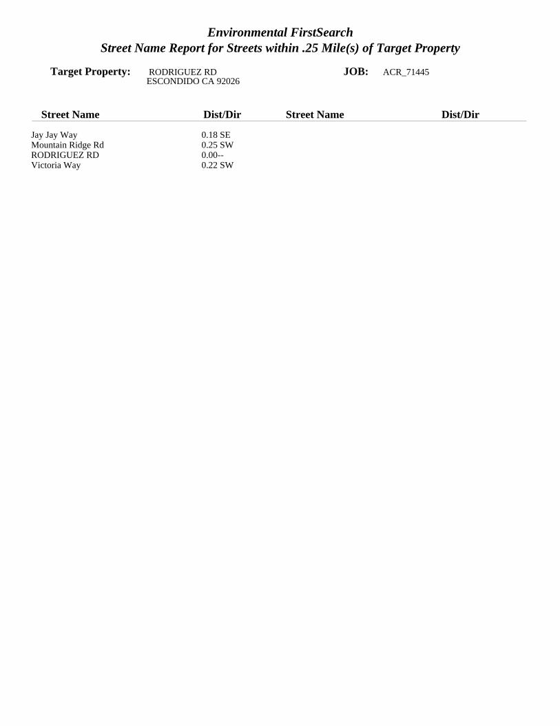
Environmental FirstSearchStreet Name Report for Streets within .25 Mile(s) of Target Property
Target Property: RODRIGUEZ RD JOB: ACR_71445ESCONDIDO CA 92026
Street Name Dist/Dir Street Name Dist/Dir
Jay Jay Way 0.18 SEMountain Ridge Rd 0.25 SWRODRIGUEZ RD 0.00--Victoria Way 0.22 SW
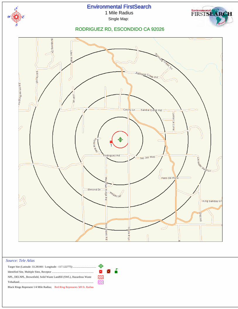
Environmental FirstSearch1 Mile Radius
Single Map:
RODRIGUEZ RD, ESCONDIDO CA 92026
Source: Tele Atlas
Target Site (Latitude: 33.281001 Longitude: -117.122775) ..................................
Identified Site, Multiple Sites, Receptor .............................................................
NPL, DELNPL, Brownfield, Solid Waste Landfill (SWL), Hazardous Waste
Triballand.............................................................................................................
Black Rings Represent 1/4 Mile Radius; Red Ring Represents 500 ft. Radius
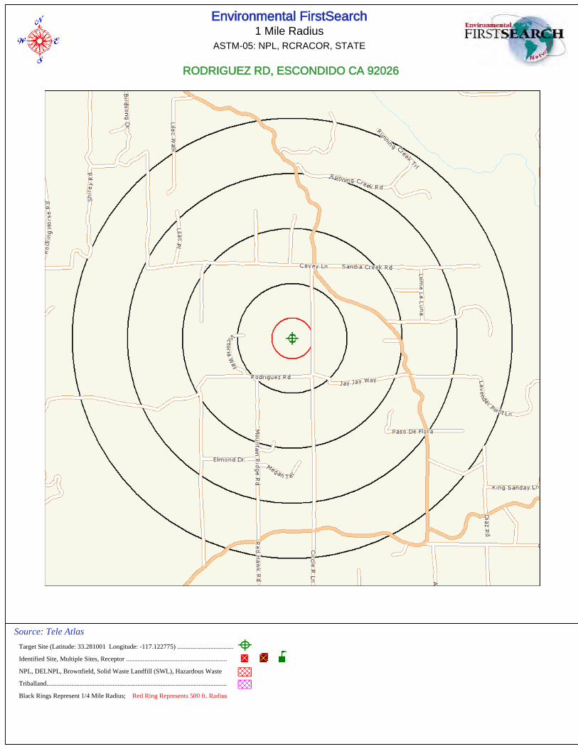
Environmental FirstSearch1 Mile Radius
ASTM-05: NPL, RCRACOR, STATE
RODRIGUEZ RD, ESCONDIDO CA 92026
Source: Tele Atlas
Target Site (Latitude: 33.281001 Longitude: -117.122775) ..................................
Identified Site, Multiple Sites, Receptor .............................................................
NPL, DELNPL, Brownfield, Solid Waste Landfill (SWL), Hazardous Waste
Triballand.............................................................................................................
Black Rings Represent 1/4 Mile Radius; Red Ring Represents 500 ft. Radius
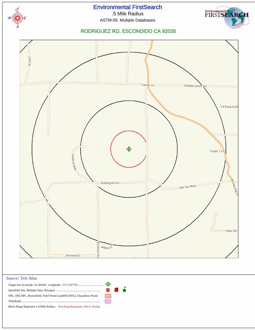
Environmental FirstSearch.5 Mile Radius
ASTM-05: Multiple Databases
RODRIGUEZ RD, ESCONDIDO CA 92026
Source: Tele Atlas
Target Site (Latitude: 33.281001 Longitude: -117.122775) ..................................
Identified Site, Multiple Sites, Receptor .............................................................
NPL, DELNPL, Brownfield, Solid Waste Landfill (SWL), Hazardous Waste
Triballand.............................................................................................................
Black Rings Represent 1/4 Mile Radius; Red Ring Represents 500 ft. Radius
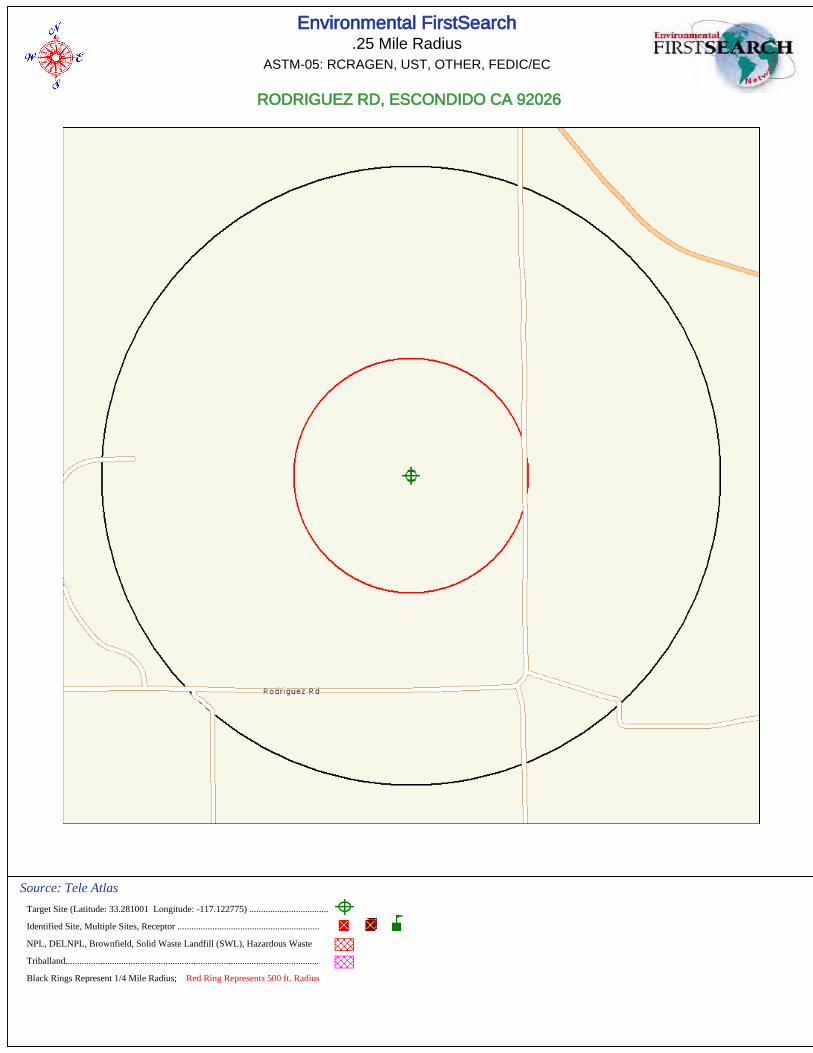
Environmental FirstSearch.25 Mile Radius
ASTM-05: RCRAGEN, UST, OTHER, FEDIC/EC
RODRIGUEZ RD, ESCONDIDO CA 92026
Source: Tele Atlas
Target Site (Latitude: 33.281001 Longitude: -117.122775) ..................................
Identified Site, Multiple Sites, Receptor .............................................................
NPL, DELNPL, Brownfield, Solid Waste Landfill (SWL), Hazardous Waste
Triballand.............................................................................................................
Black Rings Represent 1/4 Mile Radius; Red Ring Represents 500 ft. Radius
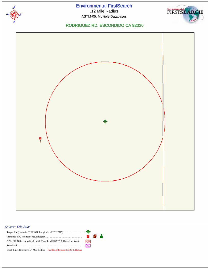
Environmental FirstSearch.12 Mile Radius
ASTM-05: Multiple Databases
RODRIGUEZ RD, ESCONDIDO CA 92026
Source: Tele Atlas
Target Site (Latitude: 33.281001 Longitude: -117.122775) ..................................
Identified Site, Multiple Sites, Receptor .............................................................
NPL, DELNPL, Brownfield, Solid Waste Landfill (SWL), Hazardous Waste
Triballand.............................................................................................................
Black Rings Represent 1/4 Mile Radius; Red Ring Represents 500 ft. Radius
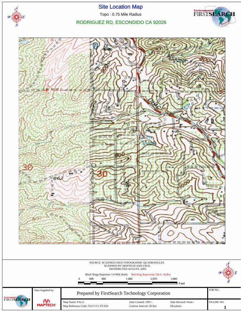
Site Location MapTopo : 0.75 Mile Radius
RODRIGUEZ RD, ESCONDIDO CA 92026
SOURCE: SCANNED USGS TOPOGRAPHIC QUADRANGLESSCANNED BY MAPTECH AND USGS
DISTRIBUTED AUGUST, 2005.
Black Rings Represent 1/4 Mile Radii; Red Ring Represents 500 ft. Radius
Data Supplied by:Prepared by FirstSearch Technology Corporation
Map Name: PALA Date Created: 1997-- Date Revised: None--
Map Reference Code: 33117-C1-TF-024 Contour Interval: 20 feet Elevation:
JOB NO.
FIGURE NO.
1
Phase I ESA and Limited Agricultural Survey April 18, 2012
Accretive Investments, Inc., “Dawson” Property – Escondido, CA EEI Project No. ACR-71445
APPENDIX E
USER PROVIDED INFORMATION
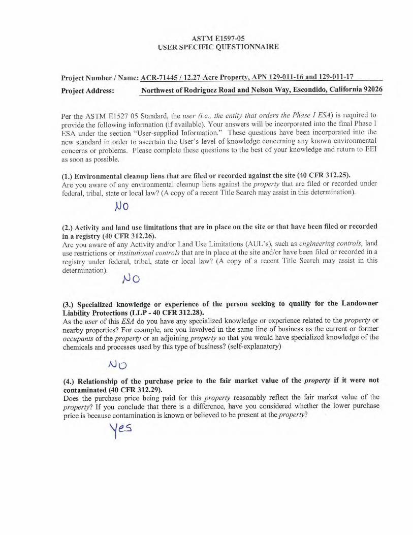
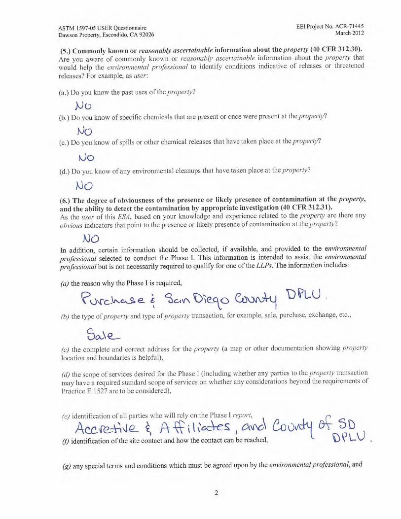
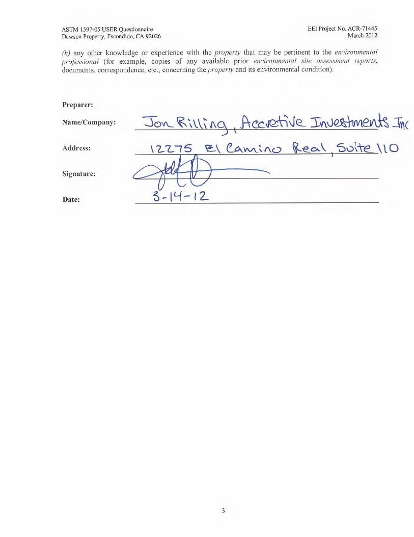
Phase I ESA and Limited Agricultural Survey April 18, 2012
Accretive Investments, Inc., “Dawson” Property – Escondido, CA EEI Project No. ACR-71445
APPENDIX F
PHOTOGRAPHIC LOG
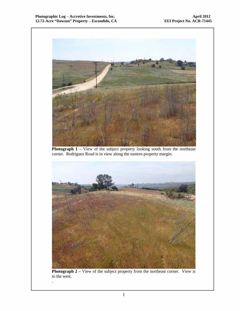
Photographic Log – Accretive Investments, Inc. April 2012
12.72-Acre “Dawson” Property – Escondido, CA EEI Project No. ACR-71445
1
Photograph 1 – View of the subject property looking south from the northeast
corner. Rodriguez Road is in view along the eastern property margin.
Photograph 2 – View of the subject property from the northeast corner. View is
to the west.
.
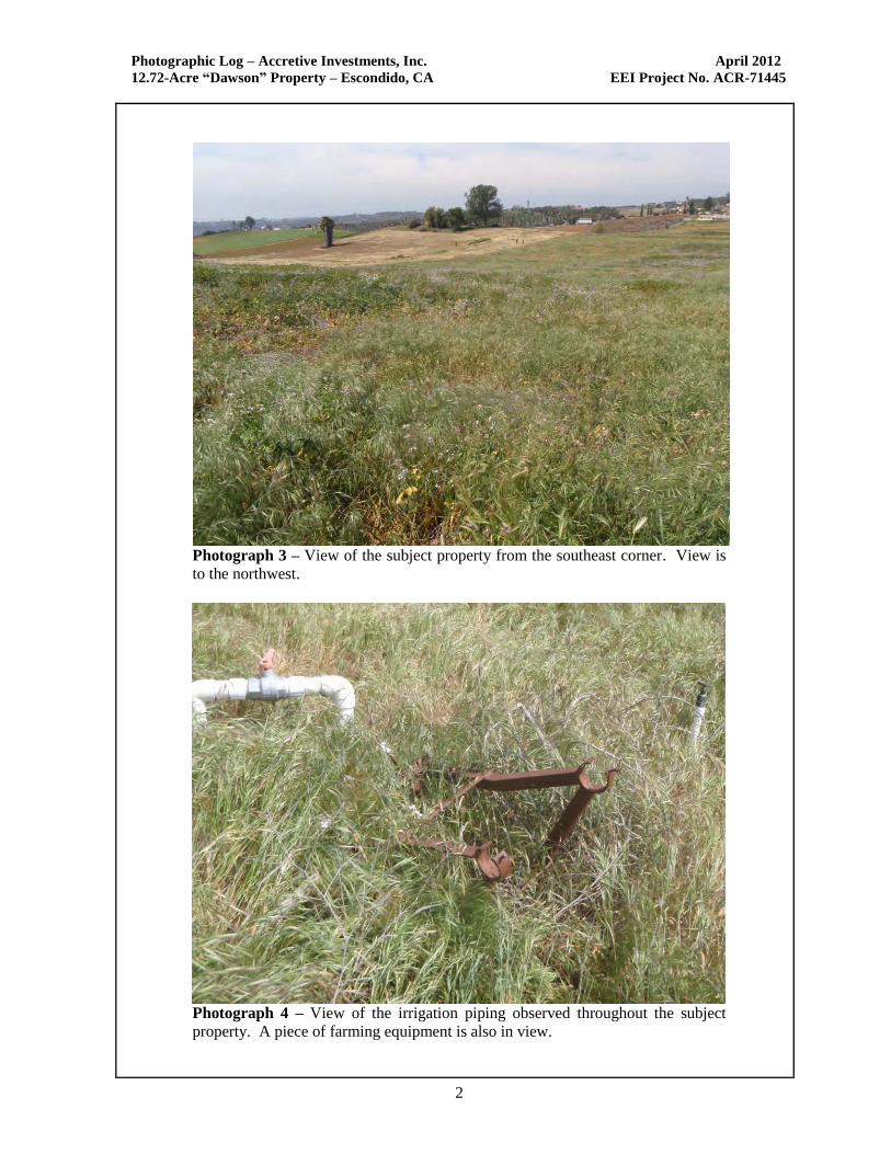
Photographic Log – Accretive Investments, Inc. April 2012
12.72-Acre “Dawson” Property – Escondido, CA EEI Project No. ACR-71445
2
Photograph 3 – View of the subject property from the southeast corner. View is
to the northwest.
Photograph 4 – View of the irrigation piping observed throughout the subject
property. A piece of farming equipment is also in view.
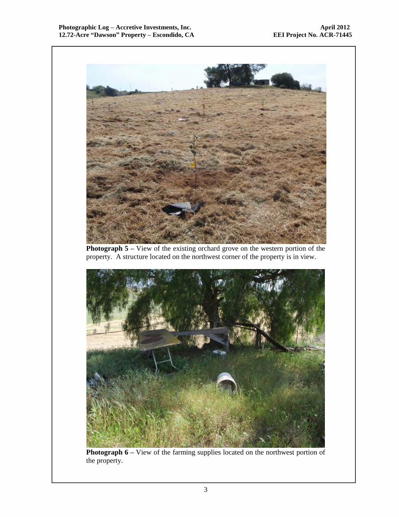
Photographic Log – Accretive Investments, Inc. April 2012
12.72-Acre “Dawson” Property – Escondido, CA EEI Project No. ACR-71445
3
Photograph 5 – View of the existing orchard grove on the western portion of the
property. A structure located on the northwest corner of the property is in view.
Photograph 6 – View of the farming supplies located on the northwest portion of
the property.
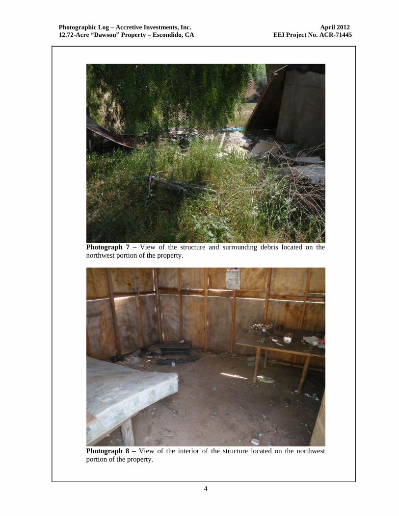
Photographic Log – Accretive Investments, Inc. April 2012
12.72-Acre “Dawson” Property – Escondido, CA EEI Project No. ACR-71445
4
Photograph 7 – View of the structure and surrounding debris located on the
northwest portion of the property.
Photograph 8 – View of the interior of the structure located on the northwest
portion of the property.