Embed Size (px)
Citation preview
Maine Geological SurveyGeology of Mount Kineo State Park
Maine Geologic Facts and LocalitiesNovember, 2018
Geology of Mount Kineo State Park,Kineo Township, Maine
Text and Photos byLindsay J. Spigel
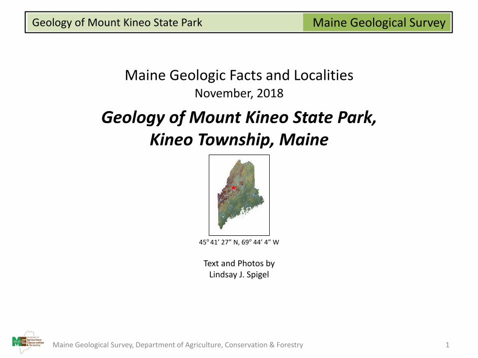
45o 41’ 27” N, 69o 44’ 4” W
Maine Geological Survey, Department of Agriculture, Conservation & Forestry 1
Maine Geological SurveyGeology of Mount Kineo State Park
Introduction
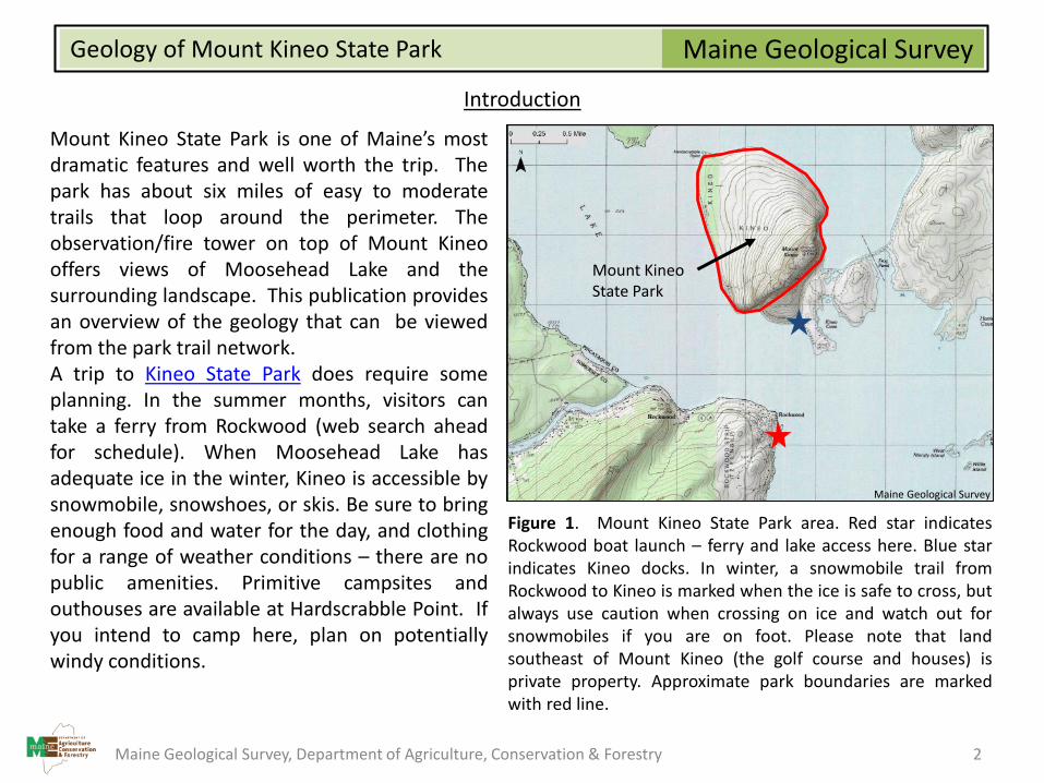
Mount Kineo State Park is one of Maine’s mostdramatic features and well worth the trip. Thepark has about six miles of easy to moderatetrails that loop around the perimeter. Theobservation/fire tower on top of Mount Kineooffers views of Moosehead Lake and thesurrounding landscape. This publication providesan overview of the geology that can be viewedfrom the park trail network.A trip to Kineo State Park does require someplanning. In the summer months, visitors cantake a ferry from Rockwood (web search aheadfor schedule). When Moosehead Lake hasadequate ice in the winter, Kineo is accessible bysnowmobile, snowshoes, or skis. Be sure to bringenough food and water for the day, and clothingfor a range of weather conditions – there are nopublic amenities. Primitive campsites andouthouses are available at Hardscrabble Point. Ifyou intend to camp here, plan on potentiallywindy conditions.
Figure 1. Mount Kineo State Park area. Red star indicatesRockwood boat launch – ferry and lake access here. Blue starindicates Kineo docks. In winter, a snowmobile trail fromRockwood to Kineo is marked when the ice is safe to cross, butalways use caution when crossing on ice and watch out forsnowmobiles if you are on foot. Please note that landsoutheast of Mount Kineo (the golf course and houses) isprivate property. Approximate park boundaries are markedwith red line.
Mount KineoState Park
Maine Geological Survey
Maine Geological Survey, Department of Agriculture, Conservation & Forestry 2
Maine Geological SurveyGeology of Mount Kineo State Park
Bedrock Geology
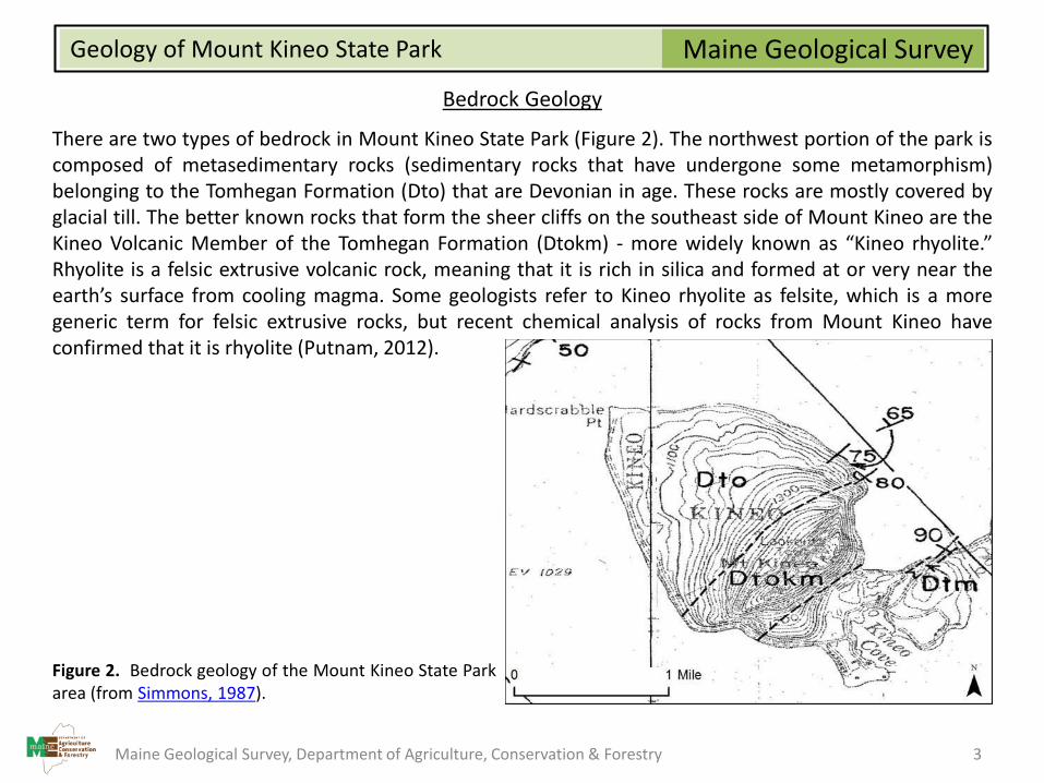
There are two types of bedrock in Mount Kineo State Park (Figure 2). The northwest portion of the park iscomposed of metasedimentary rocks (sedimentary rocks that have undergone some metamorphism)belonging to the Tomhegan Formation (Dto) that are Devonian in age. These rocks are mostly covered byglacial till. The better known rocks that form the sheer cliffs on the southeast side of Mount Kineo are theKineo Volcanic Member of the Tomhegan Formation (Dtokm) - more widely known as “Kineo rhyolite.”Rhyolite is a felsic extrusive volcanic rock, meaning that it is rich in silica and formed at or very near theearth’s surface from cooling magma. Some geologists refer to Kineo rhyolite as felsite, which is a moregeneric term for felsic extrusive rocks, but recent chemical analysis of rocks from Mount Kineo haveconfirmed that it is rhyolite (Putnam, 2012).
Figure 2. Bedrock geology of the Mount Kineo State Parkarea (from Simmons, 1987).
Maine Geological Survey, Department of Agriculture, Conservation & Forestry 3
Maine Geological SurveyGeology of Mount Kineo State Park
Surficial Geology and Geomorphology
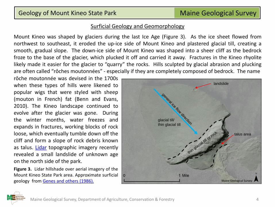
Mount Kineo was shaped by glaciers during the last Ice Age (Figure 3). As the ice sheet flowed fromnorthwest to southeast, it eroded the up-ice side of Mount Kineo and plastered glacial till, creating asmooth, gradual slope. The down-ice side of Mount Kineo was shaped into a sheer cliff as the bedrockfroze to the base of the glacier, which plucked it off and carried it away. Fractures in the Kineo rhyolitelikely made it easier for the glacier to “quarry” the rocks. Hills sculpted by glacial abrasion and pluckingare often called “rôches moutonnées” - especially if they are completely composed of bedrock. The namerôche moutonnée was devised in the 1700swhen these types of hills were likened topopular wigs that were styled with sheep(mouton in French) fat (Benn and Evans,2010). The Kineo landscape continued toevolve after the glacier was gone. Duringthe winter months, water freezes andexpands in fractures, working blocks of rockloose, which eventually tumble down off thecliff and form a slope of rock debris knownas talus. Lidar topographic imagery recentlyrevealed a small landslide of unknown ageon the north side of the park.
Figure 3. Lidar hillshade over aerial imagery of theMount Kineo State Park area. Approximate surficialgeology from Genes and others (1986).
landslide
glacial till/
thin glacial till
talus area
Maine Geological Survey
Maine Geological Survey, Department of Agriculture, Conservation & Forestry 4
Maine Geological SurveyGeology of Mount Kineo State Park
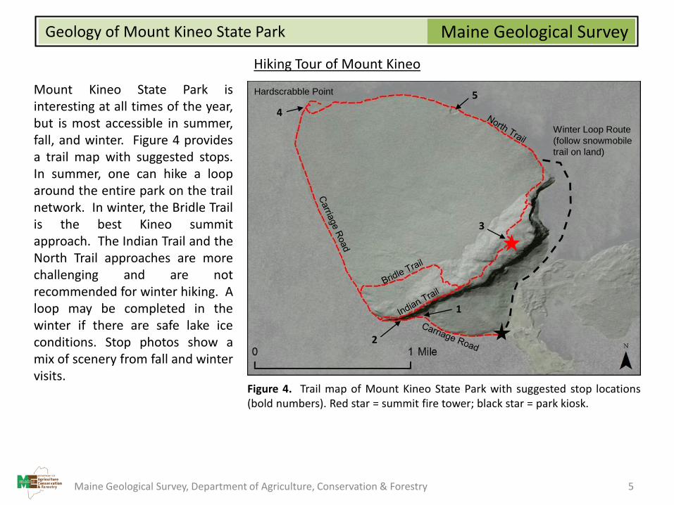
Hiking Tour of Mount Kineo
Mount Kineo State Park isinteresting at all times of the year,but is most accessible in summer,fall, and winter. Figure 4 providesa trail map with suggested stops.In summer, one can hike a looparound the entire park on the trailnetwork. In winter, the Bridle Trailis the best Kineo summitapproach. The Indian Trail and theNorth Trail approaches are morechallenging and are notrecommended for winter hiking. Aloop may be completed in thewinter if there are safe lake iceconditions. Stop photos show amix of scenery from fall and wintervisits.
Figure 4. Trail map of Mount Kineo State Park with suggested stop locations(bold numbers). Red star = summit fire tower; black star = park kiosk.
Hardscrabble Point
Winter Loop Route
(follow snowmobile
trail on land)
1
2
3
4
5
Maine Geological Survey, Department of Agriculture, Conservation & Forestry 5
Maine Geological SurveyGeology of Mount Kineo State Park
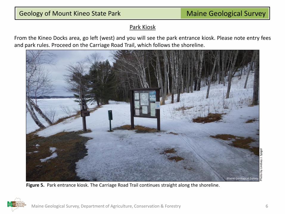
Park Kiosk
From the Kineo Docks area, go left (west) and you will see the park entrance kiosk. Please note entry feesand park rules. Proceed on the Carriage Road Trail, which follows the shoreline.
Figure 5. Park entrance kiosk. The Carriage Road Trail continues straight along the shoreline.
Ph
oto
by
Lin
dsa
y J.
Sp
igel
Maine Geological Survey
Maine Geological Survey, Department of Agriculture, Conservation & Forestry 6
Maine Geological SurveyGeology of Mount Kineo State Park
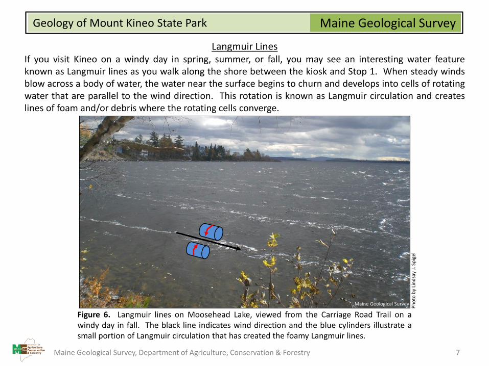
Langmuir LinesIf you visit Kineo on a windy day in spring, summer, or fall, you may see an interesting water featureknown as Langmuir lines as you walk along the shore between the kiosk and Stop 1. When steady windsblow across a body of water, the water near the surface begins to churn and develops into cells of rotatingwater that are parallel to the wind direction. This rotation is known as Langmuir circulation and createslines of foam and/or debris where the rotating cells converge.
Figure 6. Langmuir lines on Moosehead Lake, viewed from the Carriage Road Trail on awindy day in fall. The black line indicates wind direction and the blue cylinders illustrate asmall portion of Langmuir circulation that has created the foamy Langmuir lines.
Ph
oto
by
Lin
dsa
y J.
Sp
igel
Maine Geological Survey
Maine Geological Survey, Department of Agriculture, Conservation & Forestry 7
Maine Geological SurveyGeology of Mount Kineo State Park
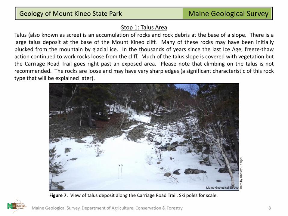
Stop 1: Talus AreaTalus (also known as scree) is an accumulation of rocks and rock debris at the base of a slope. There is alarge talus deposit at the base of the Mount Kineo cliff. Many of these rocks may have been initiallyplucked from the mountain by glacial ice. In the thousands of years since the last Ice Age, freeze-thawaction continued to work rocks loose from the cliff. Much of the talus slope is covered with vegetation butthe Carriage Road Trail goes right past an exposed area. Please note that climbing on the talus is notrecommended. The rocks are loose and may have very sharp edges (a significant characteristic of this rocktype that will be explained later).
Figure 7. View of talus deposit along the Carriage Road Trail. Ski poles for scale.
Ph
oto
by
Lin
dsa
y J.
Sp
igel
Maine Geological Survey
Maine Geological Survey, Department of Agriculture, Conservation & Forestry 8
Maine Geological SurveyGeology of Mount Kineo State Park
Stop 2: Kineo Rhyolite
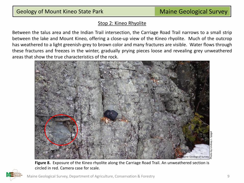
Between the talus area and the Indian Trail intersection, the Carriage Road Trail narrows to a small stripbetween the lake and Mount Kineo, offering a close-up view of the Kineo rhyolite. Much of the outcrophas weathered to a light greenish-grey to brown color and many fractures are visible. Water flows throughthese fractures and freezes in the winter, gradually prying pieces loose and revealing grey unweatheredareas that show the true characteristics of the rock.
Figure 8. Exposure of the Kineo rhyolite along the Carriage Road Trail. An unweathered section iscircled in red. Camera case for scale.
Ph
oto
by
Lin
dsa
y J.
Sp
igel
Maine Geological Survey
Maine Geological Survey, Department of Agriculture, Conservation & Forestry 9
Maine Geological SurveyGeology of Mount Kineo State Park
Stop 2: Kineo Rhyolite (continued)
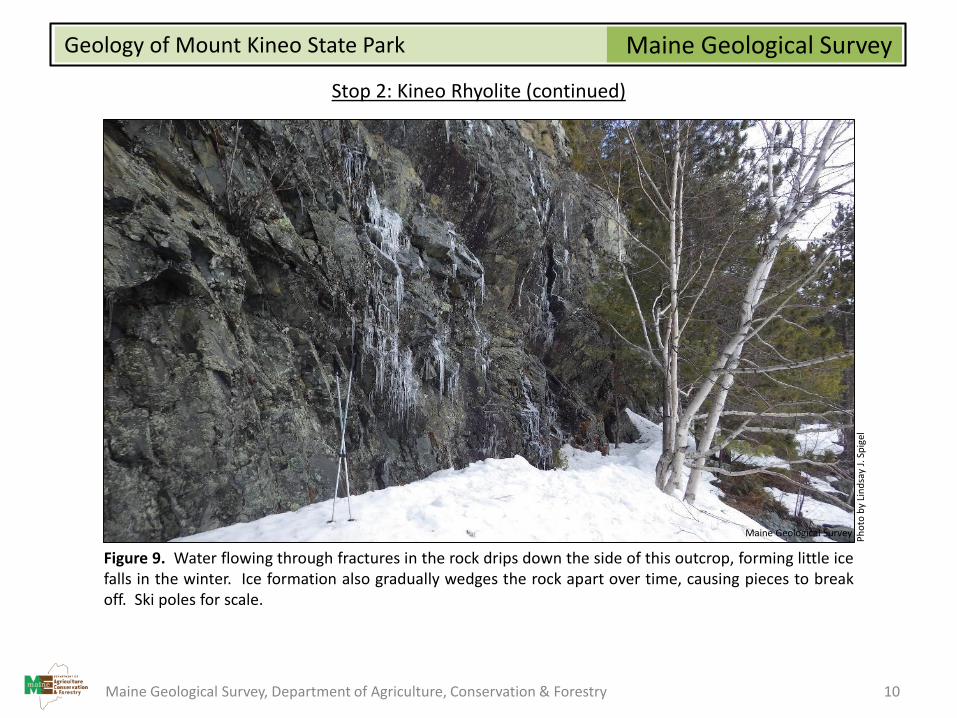
Figure 9. Water flowing through fractures in the rock drips down the side of this outcrop, forming little icefalls in the winter. Ice formation also gradually wedges the rock apart over time, causing pieces to breakoff. Ski poles for scale.
Maine Geological Survey, Department of Agriculture, Conservation & Forestry 10
Ph
oto
by
Lin
dsa
y J.
Sp
igel
Maine Geological Survey
Maine Geological SurveyGeology of Mount Kineo State Park
Stop 2: Kineo Rhyolite (continued)
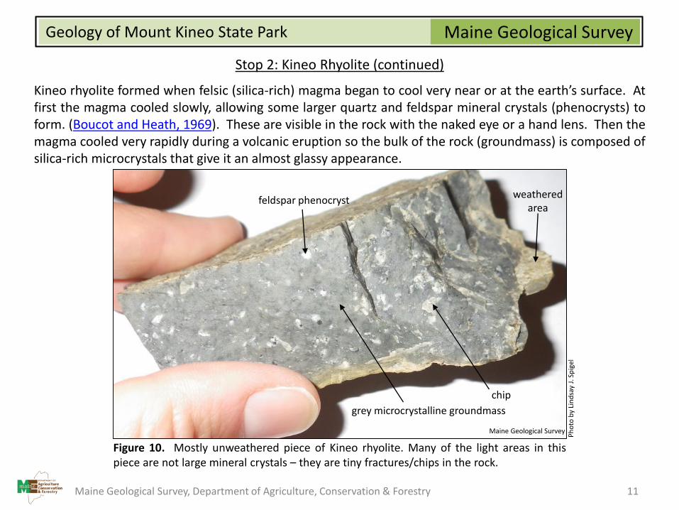
Kineo rhyolite formed when felsic (silica-rich) magma began to cool very near or at the earth’s surface. Atfirst the magma cooled slowly, allowing some larger quartz and feldspar mineral crystals (phenocrysts) toform. (Boucot and Heath, 1969). These are visible in the rock with the naked eye or a hand lens. Then themagma cooled very rapidly during a volcanic eruption so the bulk of the rock (groundmass) is composed ofsilica-rich microcrystals that give it an almost glassy appearance.
Figure 10. Mostly unweathered piece of Kineo rhyolite. Many of the light areas in thispiece are not large mineral crystals – they are tiny fractures/chips in the rock.
Ph
oto
by
Lin
dsa
y J.
Sp
igel
grey microcrystalline groundmass
feldspar phenocryst
chip
weatheredarea
Maine Geological Survey
Maine Geological Survey, Department of Agriculture, Conservation & Forestry 11
Maine Geological SurveyGeology of Mount Kineo State Park
Stop 2: Kineo Rhyolite (continued)
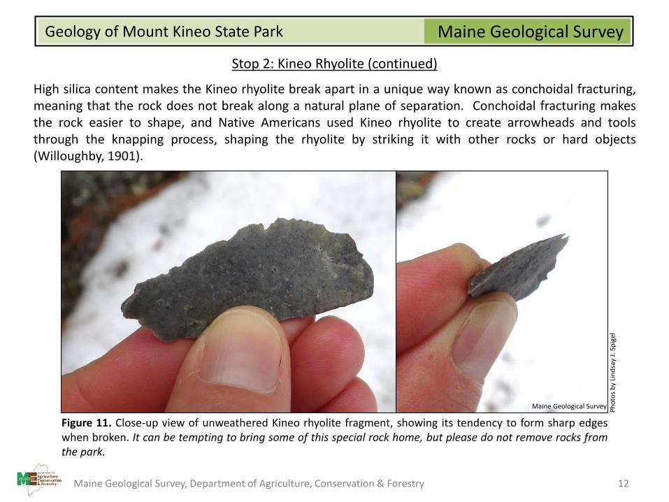
High silica content makes the Kineo rhyolite break apart in a unique way known as conchoidal fracturing,meaning that the rock does not break along a natural plane of separation. Conchoidal fracturing makesthe rock easier to shape, and Native Americans used Kineo rhyolite to create arrowheads and toolsthrough the knapping process, shaping the rhyolite by striking it with other rocks or hard objects(Willoughby, 1901).
Figure 11. Close-up view of unweathered Kineo rhyolite fragment, showing its tendency to form sharp edgeswhen broken. It can be tempting to bring some of this special rock home, but please do not remove rocks fromthe park.
Ph
oto
s b
y Li
nd
say
J. S
pig
el
Maine Geological Survey
Maine Geological Survey, Department of Agriculture, Conservation & Forestry 12

Maine Geological SurveyGeology of Mount Kineo State Park
Stop 3: Mount Kineo Summit
There are three ways to approach Mount Kineo’ssummit. If it is summer and you intend to looparound the island, you may want to take the NorthTrail, making the summit your last stop. If it issummer and you don’t intend to hike the loop, theIndian Trail is suitable for those that are okay withsteep drop-offs. If it is winter or if you would simplylike a more moderate approach, the Bridle Trail is thebest option. There is a small overlook on the way tothe summit with south/southeast views where theBridle and Indian Trails meet, but 360° views from thesummit are only available from the top of the old firetower. Use caution on the fire tower, especially inwinter or wet and windy conditions.
Figure 12. The Mount Kineo fire tower.
Ph
oto
by
Lin
dsa
y J.
Sp
igel
Maine Geological Survey
Maine Geological Survey, Department of Agriculture, Conservation & Forestry 13

Maine Geological SurveyGeology of Mount Kineo State Park
Stop 3: Mount Kineo Summit (continued)
Figure 13. View to the south from Mount Kineo summit.
Sand Bar Point Lambs Cove
Big Moose Mtn.
Ph
oto
by
Lin
dsa
y J.
Sp
igel
Maine Geological Survey
Maine Geological Survey, Department of Agriculture, Conservation & Forestry 14
Maine Geological SurveyGeology of Mount Kineo State Park
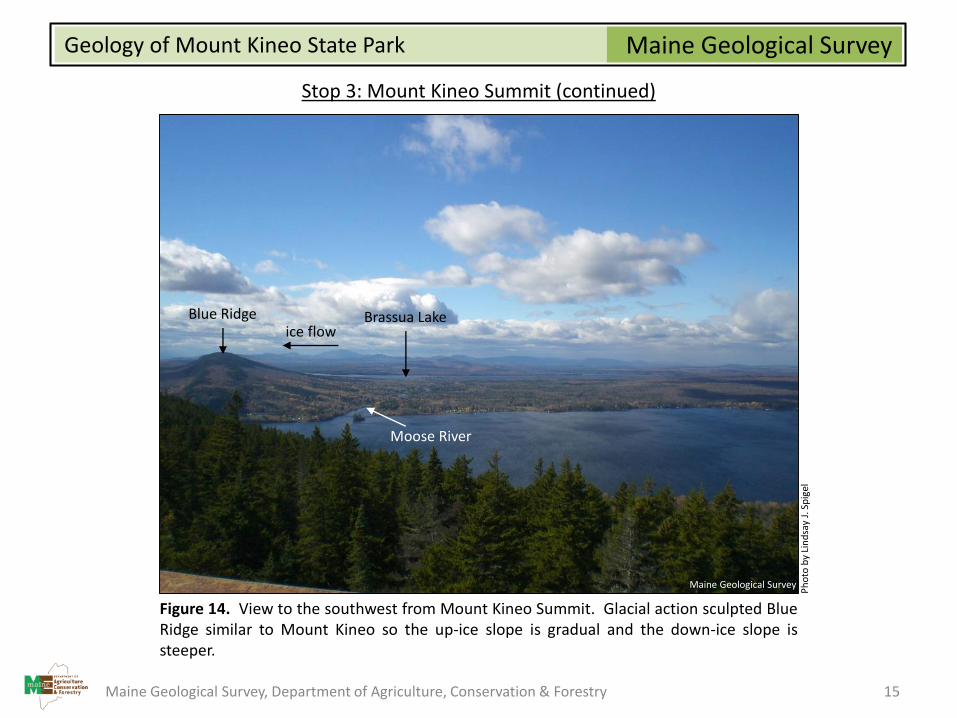
Stop 3: Mount Kineo Summit (continued)
Figure 14. View to the southwest from Mount Kineo Summit. Glacial action sculpted BlueRidge similar to Mount Kineo so the up-ice slope is gradual and the down-ice slope issteeper.
Blue Ridge Brassua Lake
Moose River
ice flow
Ph
oto
by
Lin
dsa
y J.
Sp
igel
Maine Geological Survey
Maine Geological Survey, Department of Agriculture, Conservation & Forestry 15

Maine Geological SurveyGeology of Mount Kineo State Park
Stop 3: Mount Kineo Summit (continued)
Figure 15. View to the northwest from Mount Kineo summit. This view illustrates thegentle, up-ice slope of Mount Kineo.
Farm IslandHardscrabble Point
Ice Flow
Directio
n
Ph
oto
by
Lin
dsa
y J.
Sp
igel
Maine Geological Survey
Maine Geological Survey, Department of Agriculture, Conservation & Forestry 16
Maine Geological SurveyGeology of Mount Kineo State Park
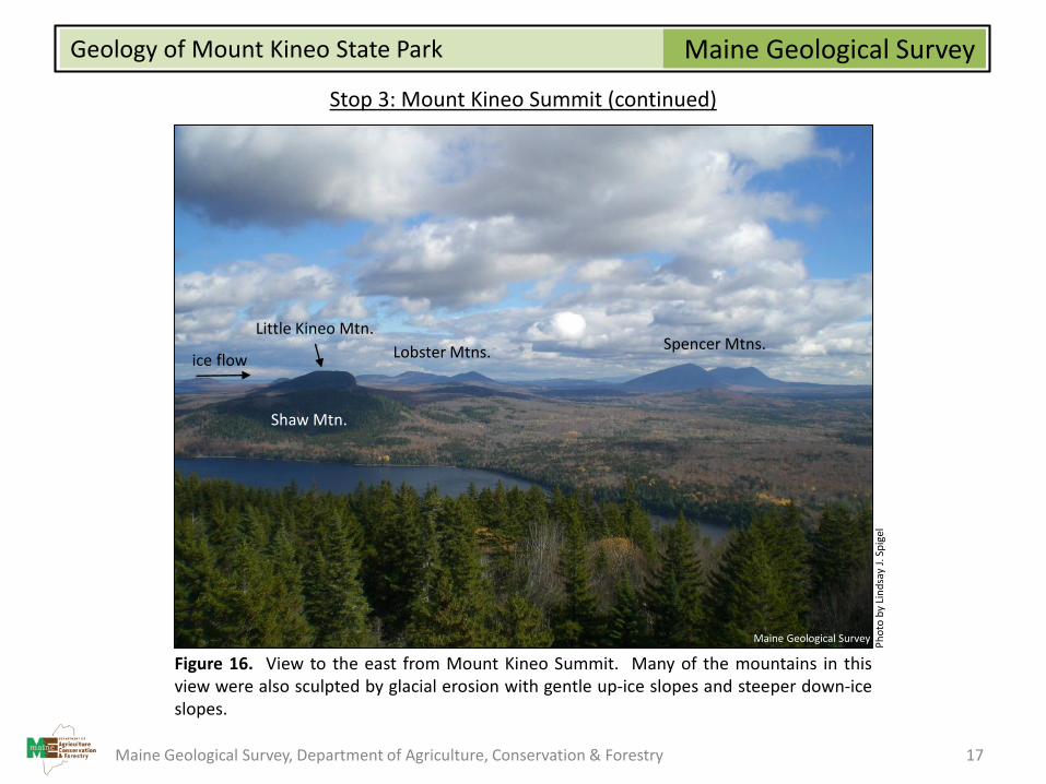
Stop 3: Mount Kineo Summit (continued)
Figure 16. View to the east from Mount Kineo Summit. Many of the mountains in thisview were also sculpted by glacial erosion with gentle up-ice slopes and steeper down-iceslopes.
Shaw Mtn.
Little Kineo Mtn.Spencer Mtns.Lobster Mtns.ice flow
Ph
oto
by
Lin
dsa
y J.
Sp
igel
Maine Geological Survey
Maine Geological Survey, Department of Agriculture, Conservation & Forestry 17
Maine Geological SurveyGeology of Mount Kineo State Park
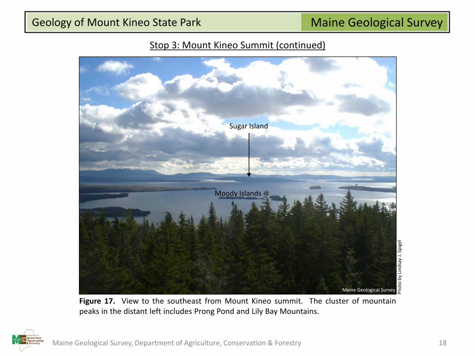
Stop 3: Mount Kineo Summit (continued)
Figure 17. View to the southeast from Mount Kineo summit. The cluster of mountainpeaks in the distant left includes Prong Pond and Lily Bay Mountains.
Maine Geological Survey, Department of Agriculture, Conservation & Forestry 18
Moody Islands
Sugar Island
Ph
oto
by
Lin
dsa
y J.
Sp
igel
Maine Geological Survey

Maine Geological SurveyGeology of Mount Kineo State Park
Boulders
After you return to the Carriage Trail and make your way towards Hardscrabble Point, keep an eye out inthe woods for large boulders that were transported by glacial ice. These boulders are also a good clue thatthe surrounding area is covered by glacial till, which is a mix of sediments (clay to boulder-sized particles)that were picked up, transported, and deposited by glacial ice.
Figure 18. A glacially transported boulder just off the Carriage Road Trail. Ski poles forscale.
Ph
oto
by
Lin
dsa
y J.
Sp
igel
Maine Geological Survey
Maine Geological Survey, Department of Agriculture, Conservation & Forestry 19
Maine Geological SurveyGeology of Mount Kineo State Park
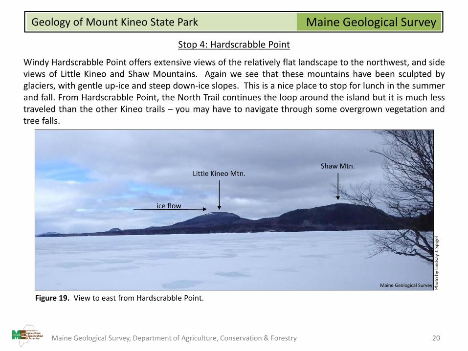
Stop 4: Hardscrabble Point
Windy Hardscrabble Point offers extensive views of the relatively flat landscape to the northwest, and sideviews of Little Kineo and Shaw Mountains. Again we see that these mountains have been sculpted byglaciers, with gentle up-ice and steep down-ice slopes. This is a nice place to stop for lunch in the summerand fall. From Hardscrabble Point, the North Trail continues the loop around the island but it is much lesstraveled than the other Kineo trails – you may have to navigate through some overgrown vegetation andtree falls.
Figure 19. View to east from Hardscrabble Point.
Shaw Mtn.Little Kineo Mtn.
ice flow
Ph
oto
by
Lin
dsa
y J.
Sp
igel
Maine Geological Survey
Maine Geological Survey, Department of Agriculture, Conservation & Forestry 20

Maine Geological SurveyGeology of Mount Kineo State Park
Stop 5: Landslide
The North Trail goes right across the down-slope edge (toe) of a relatively small (1⅓ acres) rotationallandslide. The age and cause of the landslide are unknown, but it may have occurred when lake waveaction undercut the base of the shoreline bluff which is about 14-18 feet high in the area. This drop to thelake is noticeable when approaching the landslide on the North Trail. The material that failed (slid) is theglacial till that covers the northwest side of Mount Kineo.
Figure 20. Lidar hillshade image of the landslide area.Compare labeled areas with the diagram in Figure 21.
toe
scarpcrater
Maine Geological Survey
Figure 21. Cartoon 3-D diagram of a rotationallandslide (modified from Highland and Bobrowsky(2008)). In this type of landslide, material movesdown and out along a curved plane.
Maine Geological Survey, Department of Agriculture, Conservation & Forestry 21
Maine Geological SurveyGeology of Mount Kineo State Park
Stop 5: Landslide (continued)
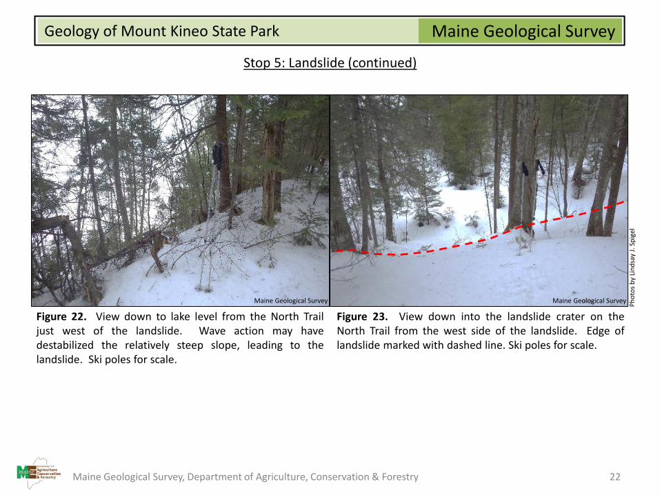
Figure 22. View down to lake level from the North Trailjust west of the landslide. Wave action may havedestabilized the relatively steep slope, leading to thelandslide. Ski poles for scale.
Figure 23. View down into the landslide crater on theNorth Trail from the west side of the landslide. Edge oflandslide marked with dashed line. Ski poles for scale.
Ph
oto
s b
y Li
nd
say
J. S
pig
el
Maine Geological Survey Maine Geological Survey
Maine Geological Survey, Department of Agriculture, Conservation & Forestry 22
Maine Geological SurveyGeology of Mount Kineo State Park
Stop 5: Landslide (continued)
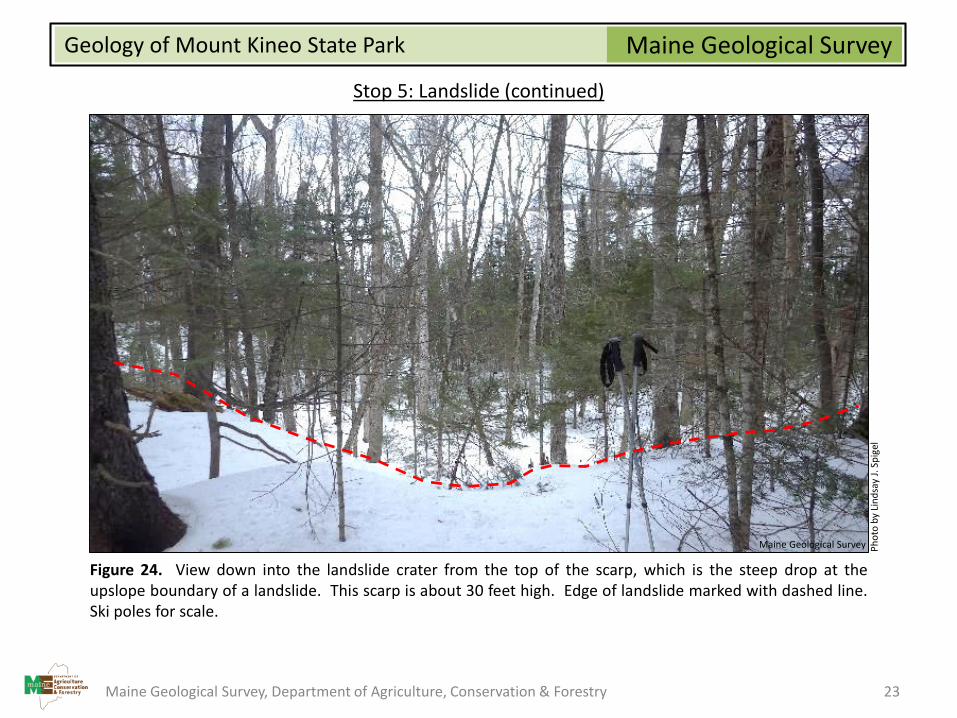
Figure 24. View down into the landslide crater from the top of the scarp, which is the steep drop at theupslope boundary of a landslide. This scarp is about 30 feet high. Edge of landslide marked with dashed line.Ski poles for scale.
Ph
oto
by
Lin
dsa
y J.
Sp
igel
Maine Geological Survey
Maine Geological Survey, Department of Agriculture, Conservation & Forestry 23

Maine Geological SurveyGeology of Mount Kineo State Park
Stop 5: Landslide (continued)
Figure 25. View of subtle slide blocks in the landslide crater. Slide blocks are chunks of earth material(glacial till in this example) that stuck together and moved as individual units during the landslide. Tops ofthe slide block ridges are marked with dashed lines. Ski poles for scale.
Ph
oto
by
Lin
dsa
y J.
Sp
igel
Maine Geological Survey
Maine Geological Survey, Department of Agriculture, Conservation & Forestry 24
Maine Geological SurveyGeology of Mount Kineo State Park
Kineo Cliffs
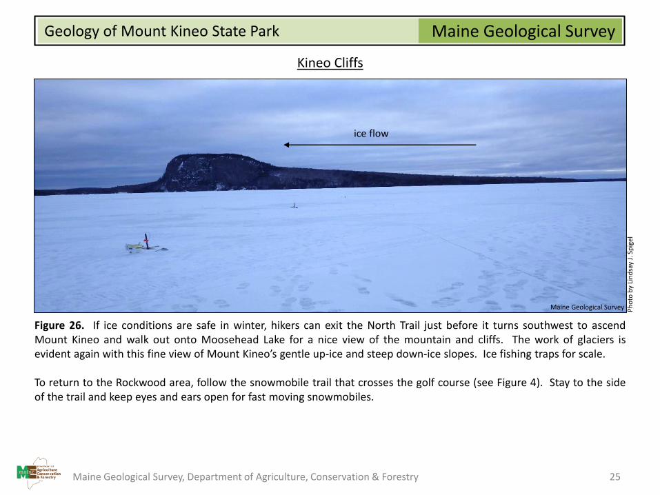
Figure 26. If ice conditions are safe in winter, hikers can exit the North Trail just before it turns southwest to ascendMount Kineo and walk out onto Moosehead Lake for a nice view of the mountain and cliffs. The work of glaciers isevident again with this fine view of Mount Kineo’s gentle up-ice and steep down-ice slopes. Ice fishing traps for scale.
To return to the Rockwood area, follow the snowmobile trail that crosses the golf course (see Figure 4). Stay to the sideof the trail and keep eyes and ears open for fast moving snowmobiles.
ice flow
Ph
oto
by
Lin
dsa
y J.
Sp
igel
Maine Geological Survey
Maine Geological Survey, Department of Agriculture, Conservation & Forestry 25
Maine Geological SurveyGeology of Mount Kineo State Park
Kineo Cliffs (continued)
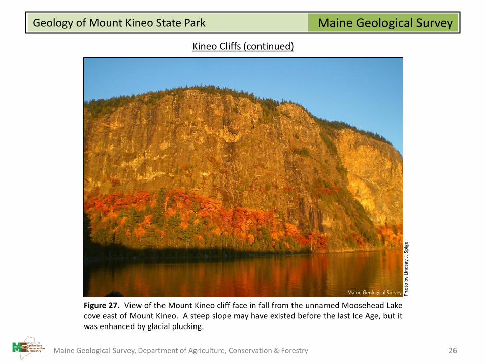
Figure 27. View of the Mount Kineo cliff face in fall from the unnamed Moosehead Lakecove east of Mount Kineo. A steep slope may have existed before the last Ice Age, but itwas enhanced by glacial plucking.
Ph
oto
by
Lin
dsa
y J.
Sp
igel
Maine Geological Survey
Maine Geological Survey, Department of Agriculture, Conservation & Forestry 26
Maine Geological SurveyGeology of Mount Kineo State Park
References
Benn, D.I., and Evans, D.J.A., 2010, Glaciers and glaciation, 2nd ed.: New York, New York, U.S., Routledge, 802 p.
Boucot, A. J., and Heath, E. W., 1969, Geology of the Moose River and Roach River synclinoria, northwestern Maine: Maine Geological Survey(Department of Economic Development), Bulletin 21, 117 p. report, 8 figs., 5 tables, 1 app., 30 plates, cross section, scale 1:62,500.https://digitalmaine.com/mgs_maps/2055
Genes, A. N., Caldwell, D. W. and Hanson, L. S., 1986, Reconnaissance surficial geology of the Moosehead Lake [15-minute] quadrangle,Maine: Maine Geological Survey, Open-File Map 86-34, map, scale 1:62,500. https://digitalmaine.com/mgs_maps/620
Highland, L.M., and Bobrowsky, P., 2008, The landslide handbook—A guide to understanding landslides: Reston, Virginia, U.S. GeologicalSurvey Circular 1325, 129 p.
Putnam, I. E., 2012, Characterization of the Traveler and Kineo Rhyolites and Implications for Geoarcheology.: M.S. Thesis, University ofMaine, Orono, Maine, 164 p.
Simmons, R., 1987, Bedrock geology of portions of the North East Carry and Moosehead Lake [15-minute] quadrangles, Maine: MaineGeological Survey, Open-File Report 87-22, 17 p. report, map, cross section, scale 1:62,500. https://digitalmaine.com/mgs_maps/204
Willoughby, C. C., 1901, Prehistoric workshops at Mt. Kineo, Maine: The American Naturalist, v. 35, p. 213-219.
Maine Geological Survey, Department of Agriculture, Conservation & Forestry 27