Embed Size (px)
Citation preview
NTD Mapping Tool 2.0An enhanced version of the interactive mapping toolfor control of neglected tropical diseases (NTD)
The NTD Mapping Tool 2.0 is a user-friendly interactive tool to help plan and implement NTD control activities.This new version offers offline functionality and uses Google technology to increase your mapping possibilities.
NTD program managers and planners can customize one map to highlight which diseases are endemic, whatprogress has been made to control them, and where co-implementation is possible.
The tool contains information on lymphatic filariasis, schistosomiasis, soil-transmitted helminths andtrachoma, as well as data on access to improved sanitation and improved water sources.
Objectives:
• To visualize the geographical distribution of NTDs
• To identify priority areas requiring mass drug administration
• To identify areas for co-implementation of control activities
• To visually explore the relationship between NTDs and water and sanitation
• To track progress in NTD control
www.NTDMap.org
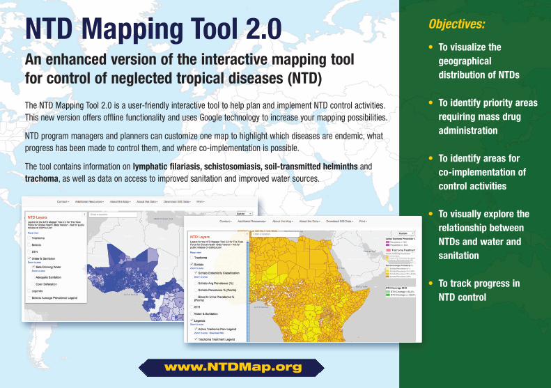
www.NTDMap.org
OnlineGo to www.NTDMap.org1. Zoom to your area of interest2. Select the layers you want to display3. Print your map, save it as an image or PDF
Offline
1. Select the “Download GIS Data” option2. Download the KML file to open all layers in Google Earth3. Download the QGIS packages to open individual layers in your GIS software
NTDMap.org is hosted on Google MapsEngine, which provides high speedprocessing and takes advantage ofuser-friendly Google technology, such asGoogle Earth.
The NTD Mapping Tool is possible thanks to funding from the Bill & Melinda Gates Foundation and the Wellcome Trust.
Using the NTD Mapping Tool is now easier than ever