Embed Size (px)
Citation preview

Numerical model predictions of autogenic fluvialterraces and comparison to climatechange expectationsAjay B S Limaye12 and Michael P Lamb1
1Division of Geological and Planetary Sciences California Institute of Technology Pasadena California USA 2Now at StAnthony Falls Laboratory University of Minnesota Twin Cities Minneapolis Minnesota USA
Abstract Terraces eroded into sediment (alluvial) and bedrock (strath) preserve an important historyof river activity River terraces are thought to form when a river switches from a period of slow verticalincision and valley widening to fast vertical incision and terrace abandonment Consequently terraces areoften interpreted to reflect changing external drivers including tectonics sea level and climate In contrastthe intrinsic unsteadiness of lateral migration in rivers may generate terraces even under constant rates ofvertical incision without external forcing To explore this mechanism we simulate landscape evolution by avertically incising meandering river and isolate the age and geometry of autogenic river terraces Modeledautogenic terraces form for a wide range of lateral and vertical incision rates and are often paired andlongitudinally extensive for intermediate ratios of vertical-to-lateral erosion rate Autogenic terraces have acharacteristic reoccurrence time that scales with the time for relief generation There is a preservation biasagainst older terraces due to reworking of previously visited parts of the valley Evolving spatial differences inbank strength between bedrock and sediment reduce terrace formation frequency and length favor pairingand can explain sublinear terrace margins at valley boundaries Age differences and geometries for modeledautogenic terraces are consistent in cases with natural terraces and overlap with metrics commonlyattributed to terrace formation due to climate change We suggest a new phase space of terrace propertiesthat may allow differentiation of autogenic terraces from terraces formed by external drivers
1 Introduction
River terraces are low-relief surfaces perched above the channel and formed by deposition and erosion ofvalley-fill sediments (ie alluvial terraces) or erosion of bedrock (ie strath terraces) [Bucher 1932 Bull1991 Pazzaglia 2013] The geometry and number of terraces differ widely For example terraces may becontiguous and occupy several topographic levels (eg Clearwater River valley Washington Figure 1a) ormay be separated and less numerous (eg Mattole River valley California Figure 1b) In some locations terracesare particularly wide and long (eg Colorado River valley Texas Figure 1d and Wind River valley WyomingFigure 1e) with boundaries that are closely (Figure 1d) or loosely (Figure 1e) associated with the neighboringriver channel Terraces are globally distributed [Montgomery 2004 Bridgland and Westaway 2008] and spana range of physiographic environments including coastal mountain ranges (eg Figures 1a and 1b) continentalinteriors (eg Figures 1c and 1e) and broad coastal plains (eg Figure 1d)
Terraces can preserve a record of channel evolution for hundreds of thousands of years [Pan et al 2003]Consequently river terraces are the principal geomorphic features for reconstructing channel aggradationand incision and one of the key constraints on long-term sediment fluxes from landscapes [Bull 1991Fuller et al 2009] to marine depositional basins [Blum and Aslan 2006 Phillips and Slattery 2006] Tectonicstudies also frequently use terraces as passive markers of deformation and rock uplift [Rockwell et al 1984Personius 1995 Pazzaglia et al 1998 Laveacute and Avouac 2000]
Terrace formation requires valley widening to bevel terrace treads and vertical incision to abandon thesesurfaces above the channel [Hancock and Anderson 2002 Montgomery 2004 Bridgland and Westaway2008] A change in the ratio of vertical-to-lateral erosion rate is commonly cited as a requirement for terraceformation [Hancock and Anderson 2002 Fuller et al 2009 Finnegan and Dietrich 2011 Langston et al 2015]and is usually attributed to changes in vertical incision rate driven by external factors including tectonics[Bull 1991 Demir et al 2009 Yanites et al 2010 DiBiase et al 2014] base level change [Fisk 1944Pazzaglia and Gardner 1993 Blum and Tornqvist 2000 Finnegan and Balco 2013] and most frequently
LIMAYE AND LAMB AUTOGENIC FLUVIAL TERRACES 1
PUBLICATIONSJournal of Geophysical Research Earth Surface
RESEARCH ARTICLE1010022014JF003392
Key Pointsbull Meandering rivers undergoing steadyincision create autogenic terraces
bull Autogenic terraces can be paired andlongitudinally extensive
bull Autogenic terraces have timescalesthat can overlap with climate forcing
Supporting Informationbull Captions for Movies S1ndashS7bull Movie S1bull Movie S2bull Movie S3bull Movie S4bull Movie S5bull Movie S6bull Movie S7
Correspondence toA B S Limayeaslimayeumnedu
CitationLimaye A B S and M P Lamb (2016)Numerical model predictions ofautogenic fluvial terraces and comparisonto climate change expectationsJ Geophys Res Earth Surf 121doi1010022014JF003392
Received 14 NOV 2014Accepted 2 FEB 2016Accepted article online 8 FEB 2016
copy2016 American Geophysical UnionAll Rights Reserved
changes in water and sediment fluxes due to climate change [Molnar et al 1994 Hancock and Anderson2002 Bridgland and Westaway 2008 Pazzaglia 2013]
Evidence for terrace formation driven by climate change primarily relates to terrace age and geometryalthough sedimentology of terrace fills is also used [Tyraacuteček et al 2004 Bridgland and Westaway 2008]Terrace age is commonly compared to paleoclimate proxies [van den Berg and van Hoof 2001 Pan et al2003 Picotti and Pazzaglia 2008 Fuller et al 2009] some of which record quasiperiodic variations such asMilankovitch cycles [Hays et al 1976] Despite these important studies relationships between terrace ageand paleoclimate records are uncertain due to dating precision limits [eg Wegmann and Pazzaglia 2002]and in the case of strath terraces uncertainty exists in the elapsed time between strath beveling anddeposition of overlying alluvium [Merritts et al 1994] In valleys where alluvial terraces have been arguedto record climate cycles there is commonly a discordance between the number of terrace levels and thenumber of inferred climate cycles [Bridgland and Westaway 2008] A variety of terrace geometric propertiesare commonly considered in order to interpret terrace origin and infer channel kinematics These propertiesinclude terrace slope [eg Merritts et al 1994 Finnegan and Dietrich 2011] terrace occurrence at similarelevation on opposite sides of a channel (ie pairing) [Merritts et al 1994] terrace width [Laveacute and Avouac2001] and terrace length [Wegmann and Pazzaglia 2002] Terrace geometries attributed to climate changeinclude pairing [Wegmann and Pazzaglia 2002] and along-valley continuity [Pazzaglia et al 1998] followingconceptual models that predict long periods of river longitudinal profile stability and strath bevelingpunctuated by vertical incision and terrace abandonment [Hancock and Anderson 2002]
Figure 1 A variety of river terrace morphologies Topographic shaded relief is overlain by previously mapped terrace extentsArrows indicate flow direction Mean terrace elevation is measured relative to the closest point on the longitudinal profile(green-yellow shading) and the range of mean terrace elevations is noted below (a) The Clearwater River Washington (476degN 1242degW mapped by Wegmann and Pazzaglia [2002] range in mean terrace elevation is 48m) (b) The Mattole RiverCalifornia (402degN 1242degW mapped by Dibblee and Minch [2008] range in mean terrace elevation is 104m) (c) The Le SueurRiver Minnesota (440degN 940degW mapped by Lusardi et al [2002] range in mean terrace elevation is 9m) (d) The ColoradoRiver Texas (302degN 975degW mapped by Barnes et al [1974a 1974b] range in mean terrace elevation is 3m) (e) The WindRiver Wyoming (423degN 1091degW mapped by Case et al [1998] range in mean terrace elevation is 141m) Topography dataare from the National Elevation Dataset 13 arc sec digital elevation model (DEM approximately 10m grid spacing)
Journal of Geophysical Research Earth Surface 1010022014JF003392
LIMAYE AND LAMB AUTOGENIC FLUVIAL TERRACES 2
Climatic and tectonic signals that would imprint thelandscape must pass the filter of surface processes[Schumm 1977 Bull 1991 Jerolmack and Paola2010 Ganti et al 2014] The terrace record of cli-mate and tectonic change in particular is compli-cated by terrace erosion [Lewin and Macklin 2003]and overprinted by autogenic terraces For exam-ple Finnegan and Dietrich [2011] showed that ifvertical erosion rate is proportional to channelslope then meander bend growth and cutoffshould cause abrupt changes in channel slope (ieknickpoints) that propagate upstream and causepulses of vertical incision that abandon terracesFor meandering streams lateral erosion rates inher-ently vary in space and time as meander bendsmigrate and cut off and as the channel belt wandersacross the valley [Brice 1974 Howard and Knutson1984 Seminara 2006] Davis [1909] hypothesizedthat a vertically incising laterally migrating channel(Figure 2a) can abandon terraces when it migratesin one direction (Figure 2b) before switchingdirection and migrating back toward its startingpoint (Figure 2c) Because the channel is incisingvertically the terrace riser is formed by lateralerosion of the cutbank (Figure 2c) and the terraceis fully abandoned when the channel changesdirection once more (Figure 2d) This mechanismhas been observed to drive terrace formation inexperimental alluvial fans [Mizutani 1998] and infield settings where engineered base level fall hasinduced rapid vertical incision [Born and Ritter1970 Ben Moshe et al 2008] Although a switchingdirection of channel migration is rarely consideredas a mechanism for forming alluvial or strath ter-races [Challinor 1932 Hack 1955 Stricklin 1961Merritts et al 1994 Erkens et al 2009] numerical
model results indicate that meandering can generate strath terraces even under constant rates of verticalincision [Limaye and Lamb 2014]
Several characteristics have been attributed to terraces formed by unsteady channel migration including aterrace slope equal to the ratio vertical-to-lateral erosion rate [Merritts et al 1994] a terrace dip directionoriented toward the valley center [Davis 1909 Merritts et al 1994] a lack of corresponding terraces acrossthe valley (ie unpaired) [Bull 1990 Merritts et al 1994 Wegmann and Pazzaglia 2002] and limited terracelength along valley [Pazzaglia et al 1998 Pazzaglia 2013] However none of these terrace properties hasbeen verified through direct field observations numerical modeling or experiments except for those ofMizutani [1998] who noted that laterally migrating vertically incising channels formed surfaces that slopeinward toward the channel
The sparsest requirement to generate terraces is a lateral erosion rate that varies in space or time as occursfor all meandering rivers and a finite rate of vertical incision [Davis 1909] In principle this basic terraceformation mechanism should be possible in all environments including valleys with alluvial or strathterraces Importantly unlike terrace generation by external drivers such as climate change [Hancock andAnderson 2002] this mechanism of autogenic terrace formation does not require the vertical incision rateto oscillate in time and therefore serves as an important null hypothesis before adopting models that requiremore complex erosion histories
Figure 2 Schematic of river terrace formation by verticalerosion and a switching direction of lateral erosion [afterMerritts et al 1994] (a) The cross section of a channel withwidthwc and depth hc The channel migrates with a constantlateral erosion rate (EL) and constant vertical erosion rate(EV) resulting in a subhorizontal channel migration direction(b) As the channel erodes laterally and vertically it planes offa bedrock (hatched area) surface Here constant channelwidth is maintained by emplacing sediment (dotted area) onthe trailing bank up to the flow depth The arrow indicatesthe mean channel migration direction (c) The direction ofnet lateral channel migration switches (d) The direction ofnet lateral channel migration reverts to its initial direction Astrath terrace is preserved because the channel does notsweep a consistent distance across the valley The samemodel holds for formation of an alluvial cut terrace
Journal of Geophysical Research Earth Surface 1010022014JF003392
LIMAYE AND LAMB AUTOGENIC FLUVIAL TERRACES 3
Herein we use a numerical model to isolate the expected age distribution and geometry of autogenic terracesformed by a meandering river undergoing steady vertical incision In section 2 we describe our specifichypotheses identify important variables and use the field cases in Figure 1 for guidance on model parame-terization In section 3 we describe the methods used for modeling channel migration and identifyingmodeled terraces automatically Section 4 presents the model results including the variety of surfacemorphologies formed by the meandering model We analyze terrace age and geometry across a broad rangeof channel lateral and vertical erosion rates and also consider cases in which variable bank strength andpulses of vertical incision influence terrace formation In section 5 we compare model results to the caseexamples given in Figure 1 We discuss implications for inferring terrace origin in section 6
2 Hypotheses and Field Examples
Meander bends have characteristic length scales [Williams 1986] and migration patterns [Hooke 2013]Consequently we hypothesize that terraces generated by meandering with constant vertical incision havecharacteristic geometries and age distributions that might set them apart from terraces driven by pulses ofvertical incision Model runs suggest that in bedrock river valleys differences in bank strength betweenalluvial sediments and bedrock can explain a variety of valley morphologies and promote unsteady lateralchannel migration and terrace formation [Limaye and Lamb 2014] Therefore we also hypothesize thatevolving bank strength differences alter the age and geometry of terraces generated by meandering withconstant vertical incision
21 Key Variables
We seek to determine the characteristics of terracesmdashincluding the time between unique terrace levels(Δtterrace) maximum terrace length (Lterracemax) terrace surface slope (Sterrace) terrace dip direction(oslashterrace) and pairing fraction (fpaired)mdashformed by meandering rivers with constant vertical incision and ina general way for both alluvial and strath terraces Following Limaye and Lamb [2014] eight parameterscan describe the kinematics of valley evolution for a mixed bedrock-alluvial meandering channel themaximum lateral erosion rate in bedrock (ELb) and sediment (ELs) vertical incision rate (Ev) channel width(wc) initial alluvial belt width (wab) and unconfined alluvial belt width (wuab) channel depth (hc) and the totalsimulation time (t) (Table A1) These eight parameters are chosen for the sparsest representation of valleyevolution by a river channel with explicitly resolved dimensions that incises vertically and migrates laterallyin sediment andor bedrock banks
Several factors may influence vertical incision rates lateral erosion rates and terrace formation includingsediment supply [Sklar and Dietrich 2001] channel slope [Stark 2006 Finnegan and Dietrich 2011] uplift rate[Laveacute and Avouac 2001 Amos and Burbank 2007 Yanites and Tucker 2010] discharge variability [Turowskiet al 2008 Stark et al 2010] channel substrate [Ferguson 1973 Finnegan et al 2005] tributaries [Gutierrezet al 2014] and hillslopes [Langston et al 2015] In addition valley widening may be carried out by braidedrather than meandering channels [Ryder and Church 1986 Finnegan and Balco 2013] Vertical and lateralerosion rates also may not be independent [eg Finnegan and Dietrich 2011] Herein we do not treat theseprocesses explicitly so that the vertical incision and lateral erosion rates can be treated as the independentvariables and varied over a wide parameter space
Using dimensional analysis the model parameters can be recast as independent nondimensional para-meters For equal maximum rates of lateral erosion (EL) in sediment and bedrock (ie EL= ELs= ELb) theseparameters include the dimensionless simulation time
t frac14 ELtwc
(1a)
the dimensionless vertical incision rate
EV frac14 EVwc
ELhc (1b)
the channel width-to-depth ratio
wc frac14 wc
hc (1c)
Journal of Geophysical Research Earth Surface 1010022014JF003392
LIMAYE AND LAMB AUTOGENIC FLUVIAL TERRACES 4
and the dimensionless initial alluvial belt width
wab frac14 wab
wuab(1d)
that describes the initial width of a sediment-filled zone one channel depth thick with respect to the esti-mated meander belt width for an unconfined case As shown by Limaye and Lamb [2014] the model resultsfor cases with variable bank material are strongly influenced by initial conditions which is why wab must beconsidered as a variable
A single variable for maximum lateral erosion rate in equations (1a) and (1b) is sufficient for evolution of avalley with banks of similar material such as the Colorado River (Figure 1d) where the banks are mostlyalluvium or the San Juan River Utah where the banks are mostly bedrock [Limaye and Lamb 2014]However in cases where differences in the strength of bank material (eg mixed bedrock and alluvial banks)influence valley evolution [Limaye and Lamb 2013 2014] we distinguish between two different lateralerosion rates for the two materials Therefore for these cases equation (1b) can be replaced by
EVb frac14 EVwc
ELbhc(2a)
and in sediment
EVs frac14 EVwc
ELshc(2b)
where ELb and ELs are the maximum lateral erosion rates in bedrock and sediment respectively For cases withvariable bank strength t (equation (1a)) is defined using the lateral erosion rate in sediment banks
Previous model runs suggested that the nondimensional vertical incision rate which reflects the ratio ofvertical-to-lateral erosion rate (equation (1b)) strongly influences the large-scale valley geometry excavatedby the river Specifically high values of the dimensionless vertical incision rate favor the formation of deepnarrow gorges rather than terraced valleys and low nondimensional vertical incision rates favor broad low-relief valleys with the potential for terraces [Limaye and Lamb 2014] Based on these results we hypothesizethat the nondimensional vertical incision rate (EV) also controls the age distribution and geometry of terracesformed during valley excavation We also hypothesize that nondimensional simulation time (t) influences theage and geometry of preserved terraces because more extensive lateral channel migration erodes existinglandforms Field data sufficient to test these hypotheses are rare but Lewin andMacklin [2003] identified alluvialdeposits consistent with selective preservation and numerical modeling results suggest that the distribution offloodplain sediment ages generated by meandering reflects preferential preservation of older sediments[Bradley and Tucker 2013] To test these specific hypotheses we performed a suite of model runs in whichwe separately varied t and EV while holding the other dimensionless variables constant
Under the assumption of uniform bank materials the dimensionless alluvial belt width wab is irrelevantbecause wab only influences channel migration if lateral erosion rates differ in sediment and bedrock[Limaye and Lamb 2014] For cases with differences in bank strength between sediment and bedrock wehypothesize that this contrast alters spatial patterns of channel migration and consequently influencesterrace age and geometry Thus to test this hypothesis we used the model to systematically explore the timeinterval between terrace levels and terrace geometry as a function of dimensionless vertical incision rate forbedrock banks (EVb) while holding wc t wab and EVs constant
Finally we are interested in whether autogenic terraces can be distinguished from those formed from exter-nally driven pulses of vertical incision when both mechanisms are operating simultaneously We hypothesizethat river lateral erosion removes terraces produced by pulses of vertical incision and overprints the valleywith autogenic terraces Using the model we test these ideas by comparing model runs under constantvertical incision to cases where vertical incision occurs in discrete pulses
22 Example Field Cases
We use the natural river valleys introduced in Figure 1 to guide selection of a realistic range for the modelvariables in equations (1a)ndash(1d) and to compare to the model results in section 5 The natural river valleysserve as a representative but not exhaustive compilation We choose these valleys because they are well
Journal of Geophysical Research Earth Surface 1010022014JF003392
LIMAYE AND LAMB AUTOGENIC FLUVIAL TERRACES 5
studied have terrace age constraints and span a wide range in terrace sizes and geometries (Figure 1) rocktypes tectonic settings erosion rates and hypothesized terrace formation mechanisms For example thevalleys of three riversmdashthe Clearwater (Figure 1a) Colorado (Figure 1d) and Wind Rivers (Figure 1e)mdashhaveterraces interpreted to record a history of unsteady vertical incision driven by climate change [Blum andValastro 1994 Hancock and Anderson 2002 Wegmann and Pazzaglia 2002] In contrast strath terraces inthe Mattole River valley (Figure 1b) are thought to form by steady vertical incision and unsteady lateralerosion [Merritts et al 1994] The Le Sueur River Minnesota (Figure 1c) is known to have undergone pulsesof vertical incision caused by a series of propagating knickpoints that generated numerous terraces [Granet al 2013] The San Juan River valley serves as an example with limited terrace development
To estimate the appropriate dimensionless variables for the field examples we use existing literature toconstrain lateral and vertical incision rates and channel dimensions (Table 1) When not reported in previouswork we estimated channel dimensions based on aerial images (Table 1) Most estimates of lateral erosionrates discussed below are temporal averages whereas our model results are cast in terms of maximum lateralerosion rates (as discussed in section 31) Therefore we estimate and report in Table 1 the maximum lateralerosion rate as 3 times the average based on results from the Howard and Knutson [1984] meanderingmodel
For the Clearwater RiverWegmann and Pazzaglia [2002] estimated an average lateral erosion rate of 125mmyrbased on the width of theirQt5 strath terrace Based on radiocarbon dates of strath terrace alluvium in the reach15 to 30 km upstream from the river mouth [Wegmann and Pazzaglia 2002] we compute a mean verticalincision rate of EV=08plusmn 04mmyr Radiocarbon dating on the Mattole River terraces constrains verticalincision rate to 07 to 18mmyr over the last 12 kyr [Merritts et al 1994] We estimate the maximum lateralerosion rate as ranging from 285plusmn 105mmyr based on two estimates of average lateral erosion rates forsimilar rivers in the region (Eel River [Fuller et al 2009] and Smith River [Finnegan and Dietrich 2011]) For theColorado River we use radiocarbon dates from Blum and Valastro [1994] (see Figure 7 of that study) to estimatean average lateral erosion rate and convert this to a maximum lateral erosion rate of 150plusmn75mmyr Using thesame age data and terrace elevations we estimate a vertical incision rate of 029plusmn 004mmyr For the WindRiver the average vertical incision rate between the WR-7 and WR-3 strath-capping gravels near RivertonWY is 015plusmn 001mmyr [Chadwick et al 1997] and the maximum lateral erosion rate is estimated as 10plusmn5mmyr using the average lateral erosion rate estimated by Hancock and Anderson [2002] For the Le SueurRiver the average vertical incision rate is 16plusmn 04mmyr since 13 ka and the maximum lateral erosion rate ismeasured historically as 300plusmn200mmyr [Gran et al 2011] Cosmogenic radionuclide dating of perched
Table 1 Estimated Parameters for Rivers Shown in Figure 1 and the San Juan Rivera
Valley Name Location wc (m) hc (m) EL (mmyr) EV (mmyr) EV tvert =ΔzEV (year)
San Juan 372degN 1099degW 53b 27c 3 plusmn 15de 016 plusmn 005f 107 (049 280) 6700 (5000 10000)Mattole 402degN 1242degW 102b 51c 285 plusmn 105g 125 plusmn 055h 088 (061 145) 800 (550 1430)Colorado 302degN 975degW 275i 80i 150 plusmn 75ej 029 plusmn 004j 007 (004 015) 3450 (3030 4000)Wind 434degN 1093degW 417k 18i 10 plusmn 5le 015 plusmn 001m 035 (022 074) 6700 (6250 7140)Le Sueur 439degN 941degW 475n 24c 300 plusmn 200n 16 plusmn 04n 011 (005 040) 630 (500 830)Clearwatero 477degN 1242degW 491b 25c 375 plusmn 187ep 08 plusmn 04p 004 (001 013) 1250 (830 2500)
aValues in parentheses indicate estimated lower and upper boundsbEstimated from aerial photographscEstimated assuming wchc = 20dEstimated for a mean lateral erosion rate in bedrock of 1mmyr approximately 1 order of magnitude slower than in more erodible sedimentary rock
[Montgomery 2004]eUncertainty estimated as 50fEstimated from Wolkowinsky and Granger [2004] and Hanks and Finkel [2005]gEstimated from bedrock lateral erosion rates in similar geologic environments by Fuller et al [2009] and Finnegan and Dietrich [2011]hEstimated from Merritts et al [1994]iBlum [1992]jEstimated from stratigraphic data from Blum and Valastro [1994] (see Figure 7 in that study)kSmalley et al [1994]lBased on estimate by Hancock and Anderson [2002]mEstimated from Chadwick et al [1997]nEstimated from Gran et al [2011]oTerrace analysis restricted to strath terraces Qt4 Qt5 and Qt6 in Wegmann and Pazzaglia [2002]pEstimated from Wegmann and Pazzaglia [2002]
Journal of Geophysical Research Earth Surface 1010022014JF003392
LIMAYE AND LAMB AUTOGENIC FLUVIAL TERRACES 6
gravels in the San Juan River valley indicates an average vertical incision rate of 016plusmn 005mmyr since 136Ma[Wolkowinsky and Granger 2004 Hanks and Finkel 2005] The banks of the San Juan River are commonly com-posed of highly resistant sandstone [Harden 1990] and we estimate a maximum lateral erosion rate 3plusmn15mmyr based on comparison to rates in weaker rocks elsewhere [Montgomery 2004] Together we finda range of values for Ev from 004 (Clearwater River) to 107 (San Juan River) (Table 1)
3 Model Formulation and Methods
It is difficult to test our hypotheses with existing terrace models because most do not include meandering[Veldkamp and van Dijke 2000 Hancock and Anderson 2002 Finnegan 2013 Langston et al 2015] or donot represent spatial differences in bank strength within valleys [Veldkamp and van Dijke 2000 Hancockand Anderson 2002 Finnegan and Dietrich 2011] Models that do includemeandering have not systematicallyanalyzed the age and geometry of simulated terraces [Lancaster 1998 Finnegan and Dietrich 2011 Limayeand Lamb 2014] In contrast to previous studies that have primarily compared terrace age to paleoclimateproxies without explicitly considering channel kinematics [Pan et al 2003 Bridgland and Westaway 2008Fuller et al 2009] we use a forward modeling approach with constant boundary conditions to explicitly testhow channel vertical and lateral erosion rates influence terrace generation
We follow the approach of Limaye and Lamb [2014] to simulate river valley evolution We use the simplestpossible numerical model that incorporates river meandering and vertical incision and tracks differences inbank strength between bedrock and sediment To limit the computational intensity of the model runs andpermit modeling of terrace evolution over timescales of 100000 years we employ a relatively simple andcommonly used model of river meandering in which channel curvature drives bend migration [Howardand Knutson 1984] This model reproduces key meandering kinematics and geometries including growthdownstream translation and asymmetry of meander bends [Howard and Knutson 1984] Known modellimitations apply primarily to channel dynamics on timescales shorter than the cutoff timescale includingsimplistic representation of hydrodynamics and sediment transport [Seminara 2006] fixed channel width[Parker et al 2011] the inability to generate compound bend shapes prior to cutoff [Lancaster and Bras2002] and other higher-order moments of channel migration [Guneralp and Marston 2012] and highersinuosity and regularity of meander bends than for natural cases [Howard and Hemberger 1991] Thesedeficiencies are at least partially mitigated over timescales longer than the cutoff timescale because the stepchange in channel planform geometry appears to dominate hydrodynamic effects [Camporeale et al 2005]cutoffs greatly increase the variety of bend shapes and alluvial meandering channels tend to maintainchannel width despite short-term differences in bank movement [Parker et al 2011 Eke et al 2014]
31 Meandering and Landscape Evolution Model
In the centerline evolution model [Howard and Knutson 1984] local lateral erosion rate is a function of localand upstream-integrated curvature
R1 seth THORN frac14 ΩRo seth THORN thornΓ intξmax
0Ro s ξeth THORNG ξeth THORNdξ
intξmax
0G ξeth THORNdξ
(3)
where R1 is the dimensionless lateral erosion rate s is the centerline node index ξ is the along-channel dis-tance and Ro= (rwc)
1 where r is the radius of curvature of the centerline at node s The sign of Ro is set aspositive where the local channel path is in the clockwise direction and negative where the path is counter-clockwise Ω and Γ are dimensionless parameters set to 1 and 25 respectively and determine the relativeweight of local (Ω) and upstream (Γ) curvature [Ikeda et al 1981] G is a weighting function
G ξeth THORN frac14 e2kCfhc
ξ (4)
with dimensionless scaling coefficient k=1 [Ikeda et al 1981] Cf is a dimensionless friction coefficient set to001 following Stoslashlum [1996] The maximum upstream distance for the integration of channel curvature isξmax where the normalized value of the weighting function falls below 1 The local dimensional lateralmigration rate at centerline node s is
Journal of Geophysical Research Earth Surface 1010022014JF003392
LIMAYE AND LAMB AUTOGENIC FLUVIAL TERRACES 7
M seth THORN frac14 keR1 seth THORNμε (5)
where ke is the lateral erosion rate constant μ is average channel sinuosity and ε is a dimensionless para-meter set to 23 [Howard and Knutson 1984]
The channel cross section is rectangular where the channel width and depth are the bankfull values A 2 yeartime step is used and represents the recurrence interval of the bankfull discharge typical for alluvial rivers[Leopold et al 1964] Given uncertainties in the formative discharge for bedrock streams [Tinkler and Wohl1998 Whipple 2004] the same time step is used for all model runs Neck cutoffs are identified where channelbanks connect with themselves chute cutoffs are not modeled [eg Sun et al 1996 Lancaster 1998 Finneganand Dietrich 2011] and overbank deposition is implicitly assumed to fill meander loops immediately followingcutoff [eg Sun et al 1996 Finnegan and Dietrich 2011] The model domain is arbitrarily large in the cross-valleydirection and periodic in the along-valley direction which permits the channel belt axis to wander freely Thealong-valley length of themodel domain is set to 120 channel widths or approximately 10meander wavelengths[Leopold and Wolman 1960] The initial topography is a flat plane with the channel inset one channel depth
The initial channel sinuosity is established by evolving an initially straight channel seeded with randommeter-scale noise for a fixed dimensionless simulation time t = 500 [Limaye and Lamb 2014] During thisinitialization phase channel bends grow and develop past the point of cutoff so that the initial random noiseconfiguration is no longer apparent At the end of the initialization phase the erodibility coefficient ke is set sothat the maximum lateral migration rate of any channel centerline node equals EL ie
ke frac14 ELR1maxμε (6)
In simulations with bank strength differences between bedrock and sediment equation (6) is replaced by
kb frac14 ELbR1maxμε (7a)
and for sediment
ks frac14 ELsR1maxμε (7b)
where kb is the lateral erosion rate coefficient for all bedrock banks and ks is the corresponding coefficient forall sediment banks
Models with spatial variations in bank strength yield predictions for meandering channel trajectories that aregenerally sensitive to grid resolution except in cases of large channel migration rates [Limaye and Lamb2013] Therefore we couple the centerline evolution model to the vector-based method of Limaye and Lamb[2013] for tracking bank materials which does not use grids We track two classes of material that can beassigned distinct erodibilities bedrock and sediment The local erosion rate coefficient is scaled according tothe fraction of bank material that is bedrock (fb) measured from the channel bed to the bankfull height
ke frac14 ks 1 f beth THORN thorn kbf b (8)
Fluxes of water and sediment are not explicitly tracked sediment is automatically emplaced along the trailingbank as the channel migrates across the valley with a thickness equal to the channel depth (Figure 2) Similarlyeroded sediment is automatically removed from the model domain except for that emplaced on the trailingedge of the channel When the channel erodes laterally it removes the entire vertical column of material thatit encounters (Movies S1ndashS7 in the supporting information which are further discussed in section 4)
We seek to explore terrace formation under simplified scenarios where we can isolate and impose verticalincision rate as a constant (equation (1b)) This assumption introduces a complication because channel slopeevolves in natural meandering channels as meander bends grow and suddenly shorten through cutoffs[Hooke 2013] and slope has been hypothesized to influence vertical incision rates [Howard and Kerby1983 Stark 2006 Finnegan and Dietrich 2011] If vertical incision rates were fixed then knickpoints formedby meander cutoff would neither propagate nor diffuse [Seidl and Dietrich 1992] and would constitute anincreasing proportion of the channel longitudinal profile In order to isolate the role of unsteady lateral ero-sion without introducing a variety of unconstrained knickpoint processes we follow Limaye and Lamb [2014]
Journal of Geophysical Research Earth Surface 1010022014JF003392
LIMAYE AND LAMB AUTOGENIC FLUVIAL TERRACES 8
and set channel slope to zero to prevent slope evolution and vertical incision rate is varied as an independentparameter Thus model behavior should most closely approximate natural streams with low slopes
32 Terrace Detection321 Simulated TerracesEach model run generates vector data for valley and channel evolution [Limaye and Lamb 2013] Thesevector data are converted to gridded surface age surface topography and bedrock topography using a10m grid spacing similar to field-scale digital elevation models (DEMs) [eg Gesch 2007] These grids areused for statistical comparison of terrace attributes To map simulated terraces objectively and rapidly weuse a new algorithm to identify terraces that is closely related to previous work [Demoulin et al 2007Stout and Belmont 2013] The algorithm reflects common methods used for mapping terraces based ongradients in digital elevation models [Fuller et al 2009 Gran et al 2011] and for classifying terraces basedon spatial relationships to other landscape features including the modern river channel and other terraces[Merritts et al 1994] Terrace identification metrics are summarized in Table 2
Terrace surfaces are identified as groups of contiguous DEM pixels that meet criteria for local relief (lt1m)and elevation relative to the channel (gt1 channel depth above the top of the channel) We measure localrelief as the standard deviation of elevation over a fixed 30m by 30m window centered on each DEM pixelThis window geometry is similar to that used in field cases using DEMs [Burrough and McDonell 1998 Gesch2007] The local relief threshold is chosen to approximate the minimum difference in elevation commonlyused to differentiate terrace tread elevations (ie Δz) [Personius 1995 van den Berg 1996 Wegmann andPazzaglia 2002 Gran et al 2013] Qualitatively the same relief threshold differentiates most low-relief terracetreads from high-relief terrace risers in DEMs of natural landscapes In addition a threshold area is applied toreduce spurious terrace detections the threshold is set at 100m2 following Fuller et al [2009] which is atypical pixel area in field-scale DEMs [eg Gesch 2007] We only consider terraces that are wider than twochannel widths and thus effectively remove misidentified cutoff loops from the terrace database
The remaining terrace objects are analyzed further for mean surface elevation age (for model runs) slopedip direction area and length (Table A1) We define terrace length as the maximum distance spanned bythe terrace parallel to the mean valley direction and nondimensionalize terrace length by channel widthFor natural terraces individual surfaces may be diachronous because of longitudinal differences inabandonment time for example due to spatially variable sediment evacuation [Weldon 1986] or knickpointpropagation [Finnegan 2013] These factors are not included in the model and in general the modeltopography does not exhibit systematic streamwise trends in surface age
We identify paired terraces in the model runs automatically and objectively A rectangular bounding box is fit toeach individual terrace and a search window with a width equal to the width of the terrace is constructed byextending the bounding box in the across-valley direction The local valley azimuth is determined by smoothingthe local channel centerline If the search window overlaps a terrace on the other side of the active channel andif the mean terrace elevations with respect to the local channel elevation differ by less than a threshold value thenthe terraces are flagged as paired Considering the threshold local relief for terrace riser definition (1m over a 30mbaseline) and the range of terrace widths (commonly tens to hundreds of meters) a single terrace tread can spanseveral meters in elevation Therefore we identify terraces withmean elevations within 2m of each other as pairedThis pairing criterion is relatively conservative because terraces with overlapping elevation ranges are classified asunpaired if the difference in mean terrace elevation exceeds 2m or if terraces are separated along the valley Wecalculate the fraction of paired terraces (fpaired) that form in our model runs and weight the results by terrace area
Table 2 Terrace Detection Parameters for Simulated Topography
Parameter Value
Threshold local relief 1mLocal relief window 30m by 30mMinimum elevation above top of channel hcThreshold terrace area 100m2
Threshold mean terrace width 2wcMaximum difference in mean elevation for paired terraces 2mThreshold elevation difference for separation into unique terrace levels 1m
Journal of Geophysical Research Earth Surface 1010022014JF003392
LIMAYE AND LAMB AUTOGENIC FLUVIAL TERRACES 9
Commonly terrace surfaces in a given catchment are grouped into unique levels according to their elevationwith respect to the channel [Baker and Penteado-Orellana 1977 Wegmann and Pazzaglia 2002 Fuller et al2009] which along with sedimentologic characteristics and ages [Baker and Penteado-Orellana 1977 Blumand Valastro 1994 Bridgland and Westaway 2008 Wegmann and Pazzaglia 2009] are used to identifysurfaces formed at similar times and by similar processes Because elevation is more readily measured thanmaterial can be dated it is rare for each terrace surface to be independently dated [eg Fuller et al 2009]Therefore in order to identify the number of unique terrace levels in a way consistent with many field studieswe classify terraces as belonging to the same level if their mean elevations fall within the same elevation binThe elevation bin height (Δz) is set at 1m consistent with reported variations of strath elevation andminimum differences in terrace elevation [Personius 1995 van den Berg 1996 Wegmann and Pazzaglia2002 Gran et al 2013] The distribution of time intervals between unique terrace levels (Δtterrace) is calculatedby sorting the unique terrace levels by mean surface age then differencing these ages Unless otherwisenoted we analyze the median value (Δtterrace50) of this distribution We also report the tails of the terraceage distribution (ie 10th [Δtterrace10] and 90th [Δtterrace90] percentiles) to quantify whether the terraces havea repeating characteristic time interval
As will be shown in the results the time interval between unique terrace levels (Δtterrace) is most stronglycontrolled by the time for vertical incision to generate relief sufficient to define a unique terrace level
tvert frac14 ΔzEV
(9)
In the analysis that follows we nondimensionalize the characteristic terrace timescale Δtterrace by tvert whichallows us to explore secondary controls on Δtterrace apart from the vertical incision rate and the elevationthreshold Δz Results presented in this framework are less sensitive to the particular threshold Δz for terracedifferentiation Thus Δtterrace50tvert = 1 corresponds to the shortest median time interval between terracesallowed by the model setup322 Natural CasesFor natural landscapes erosion hillslope processes and other landscape features (eg roads) complicateaccurate terrace detection [eg Stout and Belmont 2013] and field-based observations are often neededfor correct identification [Merritts et al 1994 Bridgland and Westaway 2008 Wegmann and Pazzaglia2009] Therefore we extracted terrace tread extents from geologic maps (partially shown in Figure 1) Inour modeling which does not incorporate along-channel slope all elevations are measured with respectto the spatially uniform elevation of the channel Therefore in order to measure natural DEM elevationswithin a reference frame consistent with the model runs for each natural DEM pixel we subtract the elevationof the channel at the nearest point along the channel planform trace This elevation correction is used tocalculate terrace attributes including mean elevation slope dip direction and pairing fraction but doesnot affect the planform terrace properties of length and area
To compare the characteristic timescales of autogenic terraces with those for our field cases we extract themean elevation of terraces mapped for the valleys in Figure 1 We calculate the median elevation differencebetween unique terrace levels in the samemanner used for the simulated terraces The terrace elevations aretranslated to a median time difference between terrace levels (Δtterrace50) using the average vertical incisionrate at each site (Table 1) and
Δtterrace frac14 Δz50EV
(10)
where Δz50 is themedian elevation difference between unique terrace levels Similarly the timescale for reliefgeneration sufficient to abandon a terrace (tvert) is estimated for each valley following equation (9) Thesecalculations assume a constant vertical incision rate for comparison purposes unsteady vertical incision rateswould yield different values of Δtterrace50 and tvert
33 Modeled Parameter Space
We analyze two sets of model runs one with constant bank strength and the other with variable bank strength(Table 3) In both cases the channel width-to-depth ratio (wc) is fixed at 20 in our model runsmdasha value within
Journal of Geophysical Research Earth Surface 1010022014JF003392
LIMAYE AND LAMB AUTOGENIC FLUVIAL TERRACES 10
the range of mixed bedrock-alluvial channels [Yanites and Tucker 2010] and alluvial meandering channels formoderate valley slopes [Parker 1976] The channel width and depth separately affect detailed model behaviorfor example depth affects meander wavelength and width affects the threshold for neck cutoffs In terms ofdimensionless parameters however the channel aspect ratio only directly affects the dimensionlessvertical incision rate (equation (1b)) so different channel aspect ratios can be accounted for through EvThough some strath terraces date to before 100 ka [Pan et al 2003] terraces are commonly dated as severalor tens of thousands of years old [Blum and Valastro 1994 Merritts et al 1994 Fuller et al 2009 Gran et al2013] Consequently in our model runs we employ a maximum dimensional simulation time (t) of100000 years
In the model runs with constant bank strength we separately vary the nondimensional vertical incision rate(EV) and the nondimensional simulation time (t) while holding the other parameters constant We vary EVfrom 0002 to 200 representing a range of maximum lateral erosion rates from 1mmyr (ie highlyresistant bedrock) to 1myr (ie highly erodible floodplain sediments) and a range of dimensional verticalincision rates from 01mmyr (ie a slowly uplifting continental interior environment) to a high of10mmyr (ie an active orogen) [Montgomery 2004] which encompasses our field examples (Table 1) Wevary t from 1 to 5000 (ie the time for the channel to migrate laterally 1 to 5000 channel widths in sedimentbank materials)
The model runs with variable bank strength involve tracking the evolving spatial distribution of bedrock andsediment and thus are more computationally intensive [Limaye and Lamb 2013] Therefore instead of anexhaustive exploration of model parameters for cases with variable bank strength we focus our analysis onthe effect of changing the strength of the bedrock banks Therefore we fix the nondimensional vertical incisionrate for sediment banks (EVs = 0002) and the nondimensional simulation time (t = 5000) and vary only EVbThe cases with variable bank strength involve an additional parameter the nondimensional width of the initialalluvial belt (wab) due to erodibility differences between sediment and bedrock In order to characterize thefirst-order influence of an alluvial belt with a finite initial width we setwab = 01 (ie the channel is initially con-finedwithin a zone of sediment fill one channel depth in thickness with bedrock at the lateral boundaries of thefill and at the channel bed) See Limaye and Lamb [2014] for model results that vary wab
The kinematic evolution of simulated meandering channels is highly sensitive to initial planform geometry[Frascati and Lanzoni 2010] which causes different patterns of erosion and terrace development for the samemodel parameters Whereas previous model runs using an identical model formulation indicated that river valleyaspect ratio is generally insensitive to initial channel planform geometry [Limaye and Lamb 2014] river terracesexhibit a greater sensitivity to initial conditions because they are finer in scale Consequently we ran the modelwith constant bank strength and a unique set of parameters 10 separate times each with a different initial chan-nel planform geometry resulting from different planimetric noise during the initialization phase
Terrace statistical distributions including the time between terrace levels and maximum terrace lengthslope dip direction and pairing fraction are computed separately for each model run and then consideredcollectively for each set of parameters We set Δtterrace as undefined when fewer than two terraces formfor more than half of the model runs with the same parameters but different initial channel geometryBecause model runs that track differences in bank strength are more computationally intensive only onerun is conducted for each unique set of parameters in these cases Therefore the results presented for caseswith variable bank strength do not account for the same variety of initial conditions as the cases withconstant bank strength The procedure for initially evolving the channel sinuosity is the same as in the modelruns with constant bank strength except that the channel is not allowed to erode laterally past bedrockboundaries during the initialization phase [Limaye and Lamb 2014]
Table 3 Model Run Parameters
Set of Model Runs t EV EVs EVb wab Number of Model Runs
Constant bank strength 1ndash5000 0002ndash200 NA NA NA 190a
Variable bank strength 5000 NA 0002 0004ndash4 01 21
aEach model run with a unique set of parameters was run 10 times each time with a different initial channel planform geometry NA not applicable
Journal of Geophysical Research Earth Surface 1010022014JF003392
LIMAYE AND LAMB AUTOGENIC FLUVIAL TERRACES 11
4 Model Predictions for Terrace Formation
In this section we present model results for terrace formation that are motivated by our hypotheses insection 2 We begin by describing terrace age and geometry for cases with constant vertical incision ratesand constant bank strength In section 42 we then consider the effects of variable bank strength on terraceformation and geometry In section 43 we compare examples of terrace formation by pulsed and constantvertical incision rates
41 Model Runs With Constant Bank Strength
Qualitatively the model runs with constant bank strength and constant vertical incision rates generate threetypes of valleys examples of which are shown in Figure 3 The large-scale geometry of the valley and theoccurrence of terraces at smaller scales are sensitive to both t which determines the amount of valleywidening and EV which determines the amount of valley deepening relative to valley widening [Limayeand Lamb 2014]
In an example of the first valley type (t = 5000 and EV = 0003 Figure 3a and Movie S1 in the supportinginformation) channel lateral migration is extensive and vertical incision is slow compared to lateral erosionso the channel erodes broad surfaces that are continuous along valley similar to the Colorado River terraces(Figure 1d) The curves in the terrace margins and in the shaded relief indicate that the surfaces form by thegrowth of numerous meander bends that each erode a separate swath Because of the relatively low verticalincision rate the channel incises vertically only minimally between successive cycles of meander loop growthand cutoff As a result the surfaces eroded by the channel have similar elevations and thus contribute toforming the same terrace surface
For an example of the second valley type (t = 108 and EV = 07 Figure 3b and Movie S2 in the supportinginformation) channel lateral migration is also extensive but the higher relative vertical incision rate impactsterrace properties in two ways First less area near the channel falls beneath the minimum elevation thresh-old for classification as a terrace so terraces occur closer to the channel Second the terraces are smallermore numerous and bounded by individual meander cutoff loops similar to the Clearwater River terraces(Figure 1a) This terrace geometry develops because under the relatively high vertical incision rate thechannel incises vertically a substantial amount between successive cycles of meander bend growth andcutoff As a result when the channel reoccupies a portion of the landscape it commonly does so at a lowerelevation and cuts a terrace riser (Figure 2c)
In an example of the third valley type (t = 5 and EV = 200 Figure 3c) channel lateral migration is limited andgreatly outpaced by vertical incision All topography takes the form of slip-off surfaces and occasionalmeander cutoff loops as is common for meanders deeply entrenched in bedrock (eg San Juan River)[Harden 1990] No terraces form because the surface slope and thus local relief is too high along thechannel-eroded surfaces for them to be classified as terraces We define this condition as ldquoslope limitedrdquo
These examples illustrate that t and EV strongly influence the number and geometry of river terraces formed
by meandering with constant vertical incision The combined influences of t and EV are quantified in thefollowing sections411 Terrace Age DistributionsFigure 4a shows the time interval between unique terrace levels (Δtterrace50tvert) as a function of t for severalfixed values of EV at which terrace formation is not slope limited For increasing EV Δtterrace50tvert is definedover a broader range of t because the channel generates more vertical relief and potentially more terracesfor the same dimensionless simulation time In general terraces do not form at the margins of parameterspace where different terrace definition thresholds are encountered Slope-limited conditions prevail for rela-tively high nondimensional vertical incision rates (EVgt 2 Figure 4b) due to the local relief threshold(Table 2) Slip-off surfaces form instead though they may be relatively narrow (Figure 3c) Terraces do notform for two additional reasons First relatively low dimensionless vertical incision rates do not generatesufficient relief for terrace formation (eg EV le 002 for t le 300 in Figure 4a) We define this condition asldquorelief limitedrdquo Second for relatively short dimensionless simulation times lateral channel migration is insuf-ficient to bevel a terrace surface (ie ldquomigration limitedrdquo as for tlt 40 in Figure 4a) Subsequent plots high-light regimes where terraces do not form for one or a combination of these reasons
Journal of Geophysical Research Earth Surface 1010022014JF003392
LIMAYE AND LAMB AUTOGENIC FLUVIAL TERRACES 12
By definition no data fall below Δtterrace50tvert = 1 (Figure 4a) because tvert represents the minimum timeinterval between terrace levels For all values of EV with defined Δtterrace50tvert Δtterrace50tvert is near unityfor relatively low t which corresponds to limited lateral channel migration Because reworking of existingsurfaces is limited in these cases the time interval between unique terrace levels is set only by the timescalefor sufficient relief generation and so Δtterrace50asymp tvert As t increases Δtterrace50tvert increases approximately
Figure 3 The surface morphologies produced by the model for constant bank strength as a function of dimensionlesssimulation time (t) and dimensionless vertical incision rate (EV) In each plan view panel flow is from left to right thechannel is indicated in blue the background is the shaded relief of topography terraces are colored according to theirmean elevation (green-yellow) and the thick black line indicates the location of the corresponding valley cross section thatstarts at the top of the model domain The range of mean terrace elevations is noted below The domain width is 120wcand all map view panels have the same scale At right topographic cross sections indicate bedrock (hatched) and sediment(dotted) (a) For t = 5000 and EV = 0003 wide and long terraces form and represent composite surfaces eroded bynumerousmeander bends Terrace elevation range is 153m (b) For t = 108 and EV = 07 numerous terraces form and aregenerally bounded by abandoned meander cutoff loops Terrace elevation range is 75m Sediment mantles terraces but isthin relative to the valley depth (c) For t = 5 and EV = 200 no terraces form because surfaces beveled by lateral channelerosion are exceedingly steep The topography consists entirely of slip-off surfaces and abandoned meander cutoff loopsWe note that although the channel sinuosity in this case has developed for a total dimensionless time of t = 505 includingthe initialization phase the topography is only altered over the nondimensional simulation time of t = 5
Journal of Geophysical Research Earth Surface 1010022014JF003392
LIMAYE AND LAMB AUTOGENIC FLUVIAL TERRACES 13
logarithmically because continued channel migration reworks areas previously visited by the channel Frequentreworking of surfaces near the channel can prevent abandonment of these areas as terraces (eg Figure 3a) oralternatively destroy existing terraces both processes result in longer time intervals between unique terracelevels The logarithmic increase inΔtterrace50tvert with dimensionless simulation time is consistent with the findingthat meander belt width increases logarithmically with simulation time [Howard 1996] The margins of themeander belt are less likely to be visited by the migrating channel than areas close to the channel [Bradleyand Tucker 2013] so areas near the channel are preferentially reworked and terraces are less likely to bepreserved there Similarly as the meander belt widens the likelihood of the channel eroding past themargins of the alluvial belt decreases and the widening rate of the alluvial belt decreases The rate of increaseof Δtterrace50tvert with increasing t is generally more pronounced for relatively low EV because the channel ismore likely to rework previously visited areas before they can be abandoned as terraces
Figure 4b shows the time interval between unique terrace levels (Δtterrace50tvert) as a function of EV for severalfixed values of t Δtterrace50tvert is undefined across a broad range of EV for tle 10 because of limited lateralchannel migration in those cases For t =100 and t = 1000 Δtterrace50tvert begins at a relatively low value(lt2) but increases sharply as EV approaches unity until Δtterrace50tvert is undefined This behavior occurs
Figure 4 Dimensionless time interval between unique terrace levels (Δtterrace50tvert) for cases with constant bankstrength as a function of dimensionless simulation time (t) and dimensionless vertical incision rate (EV) For model runsets in which one or fewer terraces typically form Δtterrace is undefined and these cases are labeled ldquono terracesrdquo Terracesmay not form due to insufficient lateral channel migration (migration limited) insufficient vertical incision to generate relieffor forming terraces (relief limited) because surface slopes formed by channel migration and vertical incision are too highfor classification as terrace treads (slope limited) or a combination of these factors (a) Δtterrace50tvert versus t for a subsetof model runs for fixed values of EV (b) Δtterrace50tvert versus EV for fixed values of t (c) Ratio of the 90th and 50thpercentiles of Δtterrace versus t for fixed values of EV (d) EV for fixed values of t
Journal of Geophysical Research Earth Surface 1010022014JF003392
LIMAYE AND LAMB AUTOGENIC FLUVIAL TERRACES 14
because the high relative rate of vertical-to-lateral erosion causes high surface slopesin areas eroded by the channel and resultsin a greater proportion of slip-off slopesrelative to terraces (Figure 3c) As the numberof terraces decreases Δtterrace50tvertincreases until there are so few terraces thatΔtterrace50tvert is undefined The transition fromforming terraces to forming slip-off surfaces issharpest near EV =1 where the vertical incisionrate typically approaches the maximum lateralerosion rate For t = 5000 Δtterrace50tvert varieswidely with EV and is greater than for othervalues of t because of increased reworking ofpreviously visited areas For the high nondi-mensional simulation time (t = 5000) and lowvalues of dimensionless vertical incision rate(EVlt 101) few terraces form (due to lowvertical incision rates) and terrace preservationis limited (due to extensive channel migration)Thus the total number of terraces isrelatively small and more sensitive to surfacereworking than for the curves with less channelmigration (ie lower values of t) which resultsin a higher variability in the time between ter-race levels
Figure 4c shows the distribution of time intervalsbetween terrace levels expressed as the ratio ofthe 90th and 50th percentiles of the timebetweenunique terrace levels as a function of t for severalfixed values of EV For all values of EVgt 0002Δtterrace90Δtterrace50 where it is defined is rela-tively small (ie lt3) for lower values of t andtypically increases with t The small value ofΔtterrace90Δtterrace50 shows that autogenic ter-races do have a characteristic reoccurrence timeThe increase in the variance of the time intervals
between unique terrace levels with increasing t indicates that terraces are destroyed by increased lateral channelmigration The rate of increase ofΔtterrace90Δtterrace50with t is similar for different values of EV for tlt 1000 but asin Figure 4a each curve is offset because model runs with lower EV require larger t to generate terraces and forΔtterrace to be defined
Figure 4d shows the variety in Δtterrace90Δtterrace50 as a function of EV and for several unique values of tThe trends in Δtterrace90Δtterrace50 are similar to those in Δtterrace50Δtvert (Figure 4b) Except for the modelruns with t = 5000 for which terrace destruction causes large variations in the terrace age distributionΔtterrace90Δtterrace50 is relatively consistent and low until it approaches EV = 1 Terrace formation is rarerfor EV = 1 and preferentially occurs on the insides of relatively rapidly migrating meander bends elsewhereslip-off surfaces form In this case the lower terrace formation frequency and the terrace association withexceptionally active meander bends may contribute to greater variety in Δtterrace90Δtterrace50412 Terrace SlopeFigure 5a shows model results for median terrace slope as a function of t for several fixed values of EVTerrace slope is generally insensitive to t except for tgt 1000 and EVlt 002 which results in steeper terraceslopes for larger t This increase in terrace slope for tgt 1000 and EVlt 002 occurs because the terraces
Figure 5 Median terrace slope (Sterrace) versus (a) dimensionlesssimulation time (t) for fixed values of dimensionless verticalincision rate (EV) and (b) EV for fixed values of t
Journal of Geophysical Research Earth Surface 1010022014JF003392
LIMAYE AND LAMB AUTOGENIC FLUVIAL TERRACES 15
formed under those conditions are broad compound surfaces formed by the sweeping of many meanderbends (Figure 3a) Consequently some terrace surface slopes are not set instantaneously during bendmigration but instead by wandering of the channel belt axis during vertical incision For relatively highvertical incision rates this wandering would leave a terrace (ie Figure 2d) but for relatively low verticalincision rates the scarp formed at the channel cutbank is often too short and is not identified as a terrace riser(section 32)
Figure 5b shows median terrace slope as a function of EV for several fixed values of t For cases in whichterraces form there is a linear relationship between median terrace slope and EV for t le 100 Thestrong collapse in the data occurs because these cases have little channel belt wandering so that thesurface slope reflects the instantaneous vertical incision rate and lateral erosion rate of the channelFor tgt 100 and EVlt 01 channel belt wandering commonly develops terraces from a composite ofsurfaces active at different times as the channel incises vertically therefore terrace slopes are slightlyhigher than expected solely based on the instantaneous imposed vertical and lateral erosion ratesThese results suggest that despite the kinematic complexity of meandering terrace slope is a reliableindicator of the relative rates of vertical-to-lateral erosion at least in cases with constant bank strengthAccounting for the influences of channel dimensions (wc and hc) on EV (equation (1b)) the fit fort le 100 implies equivalence between terrace slope and the ratio of vertical incision to maximum lateralerosion rate413 Terrace Dip DirectionFigure 6a shows an example of the distribution of terrace dip directions for a set of model runs with fixedparameters but different initial channel planform geometries Terrace dip direction is measured as thecounterclockwise angle with respect to the mean downstream-oriented valley axis Terraces withoslashterrace = 0deg dip parallel to the mean down-valley direction Similarly oslashterrace = plusmn180deg corresponds to terracedip in the up-valley direction In this example terrace dips are preferentially oriented perpendicular to thevalley axis (ie plusmn90deg) As with terrace slope terrace dip direction may either develop through the migrationof a single bend (Figure 3b) or reflect the orientation of a composite surface formed by the migration ofdifferent meander bends (Figure 3a)
Figure 6b shows the most common dip direction as a function of t for fixed values of EV For all values of EVterraces dip in approximately the valley-parallel directions (0deg and plusmn180deg) for tlt 100 and then approachvalley-perpendicular dip directions for t ge 1000 (except for EV = 02 t = 5000) Figure 6c shows the strengthof the preferred terrace dip direction expressed as the ratio of the probability for the most probable dipdirection divided by the probability for the median dip direction (PmaxPmedian) The strength of the preferredterrace dip direction is highest for tle 100 and t ge 1000 between these values of t PmaxPmedian is near unityand terraces do not show a preferred dip direction Figure 6d shows the most common dip direction (oslashterrace)as a function of EV for fixed values of t Dip direction does not respond systematically to EV but is mostclosely oriented in the valley-perpendicular direction for t ge 1000 The strength of the preferred terracedip direction does not show a consistent relationship with EV (Figure 6e) The association of terraces thatdip in the valley-perpendicular direction with large values of t (ie ge1000) indicates that these surfaces formas a consequence of channel belt wandering rather than meander bend growth because multiplegenerations of meander bend growth and cutoff occur by t = 1000 The resulting composite surfaces diptoward the center of the valley414 Terrace LengthFigure 7 showsmaximum terrace length normalized by channel width as a function of t for several fixed valuesof EV With some exceptions maximum terrace length generally increases with t because in time smaller ter-races are preferentially destroyed by reworking (Figure 7a) The maximum terrace length is set by the domainlength and is reached for cases that generate terraces with EVlt 02 and tgt 100 Model runs that vary EV forseveral fixed values of t (Figure 7b) indicate that for sufficiently long simulations maximum terrace length pla-teaus at the domain length for EVle 101 These long terraces form because of the low relative rate of vertical-to-lateral erosion and multiple generations of meander bends at different locations along the river erode acomposite surface of roughly consistent elevation (Figure 3a) There is a sharp decrease in maximum terracelength for 01lt EVlt 1 because increasing vertical incision rates cause successive generations of meanderbends to erode surfaces with larger differences in elevation This variety in surface elevations prevents the
Journal of Geophysical Research Earth Surface 1010022014JF003392
LIMAYE AND LAMB AUTOGENIC FLUVIAL TERRACES 16
formation of longitudinally extensive low-relief surfaces Instead the channel-swept areas are classified as sepa-rate and increasingly smaller terraces (Figure 3b)415 Terrace PairingPaired terraces commonly occur in our model runs Though the terraces in each pair typically form at distincttimes their differences in mean elevation are less than the threshold for classification as paired (ie 2m)Paired terraces can have either of two geometries In the first case low relative rates of vertical-to-lateral
Figure 6 Terrace dip direction inmodel runs (oslashterrace measured in degrees counterclockwise from the downstream-orientedmean valley axis) as a function of dimensionless simulation time (t) and dimensionless vertical incision rate (EV) (a) Rosediagram of oslashterrace for EV = 0002 and t = 5000 combining results from 10model runs with different initial channel planformgeometries Themaximum bin count is labeled (b) Most probable terrace dip direction versus t for fixed values of EV (c) Thestrength of the preferred terrace dip direction expressed as the ratio of the probability for the most probable dip directiondivided by the probability for the median dip direction (PmaxPmedian) versus t for fixed values of EV (d) Most probableterrace dip direction versus EV for fixed values of t (e) The strength of the preferred terrace dip direction versus EV for fixedvalues of t In Figures 6b and 6d positive and negative values of oslash indicate dip direction toward different sides of the valleyaxis and are plotted separately
Journal of Geophysical Research Earth Surface 1010022014JF003392
LIMAYE AND LAMB AUTOGENIC FLUVIAL TERRACES 17
erosion cause the channel to wander extensively while generating little relief which creates broad surfaceson either side of the channel (Figure 3a) In the second case higher vertical incision rates generate relief suffi-cient to create a terrace during the growth and cutoff of an individual meander bend and so numerous ter-races circumscribed by meander cutoff loops form on either side of the active channel (Figure 3b)
Figure 8a shows the fraction of paired terraces (fpaired) as a function of t for several fixed values of EV In allcases where terraces form fpaired exceeds 08 at the lowest values of t and declines toward 0 as tincreases In only one case (for EV = 0006) fpaired increases again after its initial decrease For model runsthat vary EV for several fixed values of t (Figure 8b) fpaired initially increases with increasing EV for t ge 100because increasing relief is generated to accommodate terraces (eg Figure 3) The fraction of pairedterraces then decreases as EV approaches 1 because relatively high vertical incision rates cause highsurface slopes that exceed the threshold for local relief in the terrace detection algorithm (Figure 3c andTable 2) and terraces that do form are more likely to be offset in elevation due to the high rates ofrelief generation416 Summary of Model Runs With Constant Bank StrengthFor all other factors equal model runs with low ratios of vertical-to-lateral erosion rate tend to produce longerterraces formed by the compound sweeping of several meander bends (Figures 3a and 7b) These terraces
Figure 7 Maximum terrace length normalized by channel width (Lterracemaxwc) versus (a) dimensionless simulation time(t) for fixed values of dimensionless vertical incision rate (EV) and (b) EV for fixed values of t
Figure 8 Fraction of paired terraces in the model domain weighted by area (fpaired) versus (a) dimensionless simulationtime (t) for fixed values of dimensionless vertical incision rate (EV) and (b) EV for fixed values of t
Journal of Geophysical Research Earth Surface 1010022014JF003392
LIMAYE AND LAMB AUTOGENIC FLUVIAL TERRACES 18
dip toward the valley center (Figure 6d) with slopes higher than the ratio of vertical-to-lateral erosion rate(Figure 5b) and have terrace recurrence ages that are relatively large (Figure 4b) In contrast terraces inmodelruns with high ratios of vertical-to-lateral erosion rate are commonly smaller and bounded by meander cutoffloops as long as surface slopes are low enough to form terraces (Figures 3b and 7b) These terraces have noparticular slope orientation their gradients are directly proportional to the ratio of vertical-to-lateral erosionrate (Figure 5b) and they form frequently with a recurrence timescale that is set by the time needed togenerate the relief of one terrace (Figure 4b) Pairing is maximized for moderate ratios of vertical-to-lateralerosion rate (Figure 8b) In time lateral erosion destroys terraces resulting in larger time gaps between ter-races (Figure 4a) and decreased pairing (Figure 8a) Terraces may not form for short simulation times dueto insufficient vertical or lateral erosion and slip-off surfaces rather than terraces form at very high relativerates of vertical-to-lateral erosion (Figures 3c and 4b)
42 Effects of Variable Bank Strength on Model Results
In this section we consider factors that control strath terrace formation and geometry for cases in which thechannel encounters mixed bedrock and alluvial bank materials For this subset of model runs we set thedimensionless initial alluvial belt width (wab) to 01 which corresponds to a zone of sediment fill one channeldepth in thickness and one tenth the width of the unconfined meander belt [Camporeale et al 2005](Figure 9a) Because of the differences in bank strength between bedrock and sediment the nondimensionalvertical incision rate takes two different forms for these model runs that each reflect the lateral erosion rate inone of the bank materials (equations (2a) and (2b)) Here we vary the nondimensional vertical incision rate forbedrock banks (EVb) from 0004 to 4 and hold the nondimensional vertical incision rate for sediment banksconstant (EVs = 0002) Because EVs is fixed the relative bank erodibility of bedrock versus sedimentdecreases as EVb increases Nondimensional simulation time is fixed to the maximum value explored inthe cases with constant bank strength (t = 5000)
Figure 9 shows examples of terrace formation for three cases with t equal to that in Figure 3a EVb isbetween the values of EV in Figures 3a and 3b Initially the channel develops sinuosity within thesediment-filled zone but turns at sharp angles where it meets the confining bedrock walls at the margin ofthe alluvial belt (Figure 9a) From this initial condition three different regimes of channel lateral migrationand terrace evolution can occur [Limaye and Lamb 2014] In the first regime the channel actively erodesthe bedrock boundaries at the edge of the alluvial belt and strath terraces form beyond themargin of the initialalluvial belt regardless of whether the channel entrenches in bedrock (Figure 9b andMovie S3 in the supportinginformation EVb = 002) In the second regime the channel initially migrates through the sediment-filled zoneand bevels the sediment-bedrock interface at the channel bed but eventually entrenches in bedrock Thisoccurs because the channel incises vertically into bedrock at a rate faster than the sediment-bedrock interfaceis beveled across the valley [Limaye and Lamb 2014] The entrenched channel abandons terraces which areusually paired (Figure 9c and Movie S4 in the supporting information EVb = 007) In the third regime thechannel remains mobile within the alluvial belt but is impeded by relatively resistant bedrock at the alluvial beltboundaries Consequently the channel consistently erodes the same portions of the alluvial belt while incisingvertically and terraces rarely form (Figure 9d and Movie S5 in the supporting information EVb = 071)Qualitatively terrace geometries in cases with bedrock and sediment more strongly resemble natural river ter-races because terrace boundaries are sublinear at valley margins (eg Figures 1a and 1b) and do not directlymirror the shorter wavelengths of individual meander loops (Figure 9)
To identify model runs in which the channel entrenches in bedrock we track the fraction of bedrock at thecutbank measured from the channel bed up to the bankfull height The channel is classified as entrenchedin bedrock if gt90 of the channel length has an all-bedrock cutbank Figure 10 differentiates cases wherethe channel is entrenched or unentrenched and cases that do not generate terraces In the followingparagraphs terrace ages and geometries for the cases with variable bank strength are compared to theresults for the model runs with constant bank strength collectively In addition we compare the results toa single case with constant bank strength and a dimensionless vertical incision rate (EV = 0002) equal tothe dimensionless vertical incision rate for sediment banks (EVs = 0002) which is indicated with a star andreferred to as the control case with constant bank strength The control case represents the distribution ofterrace properties for 10 replicate simulations (section 33)
Journal of Geophysical Research Earth Surface 1010022014JF003392
LIMAYE AND LAMB AUTOGENIC FLUVIAL TERRACES 19
Figure 10a shows the dimensionless time interval between unique terrace levels (Δtterrace50tvert) as afunction of EVb For model runs in which terraces form Δtterrace50tvert varies between 1 and 3 for all butone runmdasha similar range as for the ensemble of cases with constant bank strength (Figures 4a and 4b) butwith a greater proportion of short time intervals between terraces Δtterrace50tvert is also typically lower thanfor the control case with constant bank strength Terraces do not form for three model runs near EVb = 1 due
Figure 9 Types of terraces produced by themodel for caseswith variable bank strength Themean flowdirection in all panelsis from left to right the channel is blue and the black lines indicate cross-section locations oriented from top to bottom acrosseach model domain Terraces are colored according to their mean elevation (green-yellow) and the range of mean terraceelevations is noted below (a) The initial cross section and plan view geometry of the channel and alluvial belt in schematicform Because wablt 1 in this case the initial alluvial belt width (wab) is less than unconfined alluvial belt width (wuab) andinitially the channel is constrained to the alluvial belt boundaries Within the initial alluvial belt the banks are entirely sediment(dotted) and the sediment depth equals the channel depth Areas beyond the alluvial belt and below the elevation of thechannel bed are all bedrock (hatched) (b) A model run in which the channel erodes beyond the initial alluvial belt and createsextensive terraces (EVb = 002) The terrace elevation range is 68m (c) A model run in which the channel entrenches inbedrock and paired terraces are abandoned largely within the initial alluvial belt (EVb = 007) The terrace elevation range is43m (d) A model run in which the channel erodes vertically while largely confined to the initial alluvial belt resulting inminimal terrace formation (EVb = 071) The lone terrace has a mean elevation of 89m relative to the initial surface
Journal of Geophysical Research Earth Surface 1010022014JF003392
LIMAYE AND LAMB AUTOGENIC FLUVIAL TERRACES 20
to highly resistant bedrock boundaries that preferentially steer meander bends to migrate down-valley andconsistently sweep the alluvial belt thus preventing terrace formation (eg Figure 9d) For cases in whichterraces form there are no systematic trends between Δtterrace50tvert and EVb
Median terrace slope (Figure 10b) generally increases with EVb for EVblt 01 similar to the trend for caseswith constant bank strength (Figure 5b) but with more variability The control case with constant bankstrength yields a lower terrace slope than a majority of the cases with variable bank strength For
Figure 10 Time intervals between terrace levels and terrace geometry for cases with variable bank strength as a func-tion of nondimensional vertical incision rate for bedrock banks (EVb) For these simulations the dimensionless simula-tion time (t = 5000) and dimensionless vertical incision rate for sediment banks (EVs = 0002) are fixed so increasingEVb is equivalent to increasing bedrock bank strength Model results for control cases with constant bank strength (witht = 5000 and EV = 0002) are indicated with black stars (a) Median time between unique terrace levels (Δtterrace50tvert) versus EVb (b) Median terrace slope (Sterrace) versus EVb (c) Most probable terrace dip direction (oslashterrace)measured in degrees counterclockwise from the downstream-oriented valley axis versus EVb (d) Maximum terracelength (normalized by channel width) versus EVb (e) Fraction of paired terraces in the model domain weighted by area(fpaired) versus EVb
Journal of Geophysical Research Earth Surface 1010022014JF003392
LIMAYE AND LAMB AUTOGENIC FLUVIAL TERRACES 21
EVbgt 01 terrace slopes no longer increase Thus terrace slope is a less reliable indicator of the ratio ofvertical-to-lateral erosion rate when bank materials are not uniform
The preferred terrace dip direction (Figure 10c) shows no consistent relationship with EVb and for severaldata points terraces preferentially dip valley perpendicular (ie plusmn90deg) In comparison a valley-perpendicularterrace dip direction occurs for a more continuous range of dimensionless vertical incision rate for cases withconstant bank strength with t ge 1000 (Figure 6b) including the control case with constant bank strengthMaximum terrace length (Figure 10d) approaches the domain length for EVblt 102 similar to cases withconstant bank strength (Figure 7) maximum terrace length generally declines as EVb increases except fortwo entrenched cases
Paired terraces in the cases with variable bank strength form through two mechanisms First in cases withrelatively erodible bedrock and thus low vertical incision rates (ie EVb le 003 Figure 9b) paired terracesform by channel belt wandering with low-relief generation similar to cases with constant bank strengthSecond channel entrenchment in bedrock can abandon extensive paired terraces in the former alluvialbelt (Figure 9c) For the range of EVb explored in the model runs terraces do not occur simultaneouslyalong adjacent growing meander bends as occurs in cases for the model runs with constant bankstrength The fraction of paired terraces (Figure 10e) does not vary systematically with EVb but the highestvalues of fpaired occur for EVblt 01 except for cases in which the channel entrenches Paired terraces arerelatively rare for EVbgt 01 The control case with constant bank strength does not generatepaired terraces
In summary with significant differences in sediment and bedrock bank strength terraces have smaller agedifferences are reduced in length and are more commonly paired These differences are consistent withreduced lateral migration due to the presence of resistant bedrock which in cases becomes the dominantbank material due to channel entrenchment Bedrock banks limit the cross-valley growth of meander bendsand suppress formation of extensive compound surfaces by multiple meander sweeps The evolving spatialdifferences in bank strength can steer the channel away from areas it has already migrated across whichfavors preservation of terraces formed closely in time These unsteady migration patterns coupled withvertical incision cause the formation of surfaces whose slopes and dip directions are less deterministic thanfor cases without bank strength differences
43 Effects of Pulses of Vertical Incision on Model Results
Here we present a simple example rather than an exhaustive exploration of parameter space to show howautogenic terraces may overprint terraces formed by pulses of vertical incision Figure 11 shows topographyformed by a meandering river over 100000 years for three scenarios the first with pulsed vertical incision ona repeating 25000 year timescale the second for a constant vertical incision rate (similar to model runs insection 41) and the third with pulses of vertical incision with greater amplitude but shorter durationthan in the first case The total vertical incision is the same in all cases bank strength is constant and themaximum lateral erosion rate (1myr) corresponds to sediment bank materials Thus over the course ofthe model runs the average nondimensional vertical incision rate is the same in all three cases (EV = 0004slightly greater than in Figure 3a) The nondimensional simulation time (t = 5000) is equal to that inFigures 3a and 9bndash9d and the channel width-to-depth ratio is also fixed to its baseline value(wc = 20) The different vertical incision histories (Figures 11andash11c) cause differences in topography(Figures 11dndash11f) but the lateral erosion history is the same in all three cases Mean terrace elevationsare binned at 1m intervals (ie Δz Figures 11jndash11l) mean terrace formation times are binned at 5 kyrintervals (Figures 11mndash11o) and the terrace area represented in each terrace formation time bin isnormalized by the total terrace area (Figures 11mndash11o)
Strikingly the topography formed in the two cases with pulses of vertical incision (Figures 11a and 11c)closely resembles the topography formed in the case without pulses of vertical incision (Figure 11b)Moderate differences in the topography are evidenced by the map view extent of terraces (Figures 11dndash11f) and the topographic cross sections (Figures 11gndash11i) This comparison illustrates that meandering candictate valley topography which in this scenario is relatively insensitive to the history of vertical incision Inall three model runs the terrace area distribution is dominated by terraces formed at two or fewer time
Journal of Geophysical Research Earth Surface 1010022014JF003392
LIMAYE AND LAMB AUTOGENIC FLUVIAL TERRACES 22
Figure 11 Examples of terrace formation by pulses of vertical incision (left and right panels) and constant vertical incision (center panels) (andashc) Vertical incision rateversus elapsed time (dndashf) Shaded relief of topography overlain by automatically detected terraces The channel is shown in blue and the black lines indicate cross-section locations oriented from top to bottom across each model domain Mean flow is from left to right Total vertical incision is the same in all cases Terraces arecolored according to their mean elevation (green-yellow) elevation distributions are given in Figures 11jndash11l (gndashi) Topographic cross sections indicating bedrock(hatched) and sediment (dotted) (jndashl) Histograms of mean terrace elevation binned at 1m intervals (mndasho) Histograms of mean terrace formation time (bars and leftaxis) binned at 5 kyr intervals The corresponding terrace area for each mean formation time normalized by total terrace area is also plotted (points and right axis)
Journal of Geophysical Research Earth Surface 1010022014JF003392
LIMAYE AND LAMB AUTOGENIC FLUVIAL TERRACES 23
periods from the second half of the runhighlighting the preferential preservationof younger terraces (Figures 11mndash11o)
The first case with pulsed vertical incisionincludes four full cycles of vertical incision(Figure 11a and Movie S6 in the support-ing information) Yet several more uniqueterraces levels form (Figure 11j) with differ-ent ages (Figure 11m) because the pulsesare not instantaneous and lateral channelmigration during periods of relatively highrates of vertical incision can create morethan one terrace level In comparison thecase with a constant vertical incision rateyields a greater plan view terrace extent(Figure 11e and Movie S7 in the support-ing information) and also forms severalterraces at distinct levels (Figure 11k) andtimes (Figure 11n) From section 41 thetimescale for terrace formation(Δtterrace50) for a constant vertical
incision rate is approximately 1 to 4 times the minimum time interval between terrace levels (tvert equation (9))For the model run in Figure 11e this corresponds to Δtterrace50asymp 5000 to 20000 years which approaches the25000 year period of vertical incision pulses Thus in this example the intrinsic frequency of terracegeneration by meandering is similar to the frequency of terrace formation driven by external forcing
The model run with relatively brief high-amplitude pulses of vertical incision (Figure 11c) might be expectedto produce a set of terraces with stronger distinctions in terrace elevation and terrace formation timecompared to the case with more gradual vertical incision pulses (Figure 11a) Instead the mean terraceelevations (Figure 11l) and surface formation times (Figure 11o) in the case with sharp vertical incision pulsesare similar to those in the case withmore gradual pulses (Figures 11j and 11m respectively) Notably as in thecase with gradual incision pulses the case with sharper incision pulses does not yield a direct correspon-dence between the number of pulses (Figure 11c) and the number of unique terrace formation times(Figure 11o) As with the larger-scale valley topography terrace properties are strongly influenced bymeandering and relatively insensitive to vertical incision history
5 Comparison of Model Results to Natural River Valleys
In the following sections we analyze terrace geometry for the valleys introduced in section 22 and compareterrace geometry to the model results We focus the comparison on the results in section 41 for model runswith constant bank strength and steady vertical incision rates for simplicity We also make comparisons for afixed dimensionless simulation time t = 5000 This exercise is not meant to assert that the field cases owetheir terraces to the mechanics in our model Indeed far more detailed field research dating and sedimen-tology have been devoted to these case studies than what we present here [Blum and Valastro 1994Merrittset al 1994 Hancock et al 1999 Wegmann and Pazzaglia 2002 Wolkowinsky and Granger 2004 Gran et al2013] Rather our goals are to illustrate that autogenic terraces generated by the simplest version of ourmodel (steady vertical incision with constant bank strength) can produce terraces with realistic geometriesslopes extents pairing fractions and age differences Furthermore the properties of the autogenic terracesin our model overlap in cases with expectations for terrace formation induced by climate change (as inFigure 11) suggesting that the two mechanisms are likely overprinted for some natural cases Only theMattole River strath terraces are thought to have formed by meandering and steady vertical incision[Merritts et al 1994] with the terraces from the other sites attributed to pulses of vertical incision from variousmechanisms In section 6 we discuss a possible strategy for separating autogenic terraces from those formedby other mechanisms
Figure 12 The estimated median time between terrace levels(Δtterrace50) versus the minimum time interval between terracelevels (tvert) both assuming a constant vertical incision rate at eachsite The shaded area indicates the range of time intervals betweenterrace levels in the simulations with constant vertical incision ratesError bars for the Wind River are within the plotted point
Journal of Geophysical Research Earth Surface 1010022014JF003392
LIMAYE AND LAMB AUTOGENIC FLUVIAL TERRACES 24
Besides the possibility of different terraceformation mechanisms the natural ter-races differ from those in our model runsin other ways Our model assumes that ablanket of sediment with uniform thick-ness covers strath surfaces such that ter-race surface geometry reflects strathgeometry The same assumption may nothold for field cases [Fuller et al 2009]Terrace dip direction and slope magnitudefor field cases may be altered by hillslopeprocesses including colluvium accumula-tion near terrace margins [Niviere andMarquis 2000] and terrace dissection[Wegmann and Pazzaglia 2009] Terraceslope can reflect a complicated history ofchannel gradients and knickpoint propa-gation [Frankel et al 2007 Finnegan2013] which are not included in our modelruns Moreover as explained insection 322 for all field examples the ter-
race elevations are measured with respect to the local active channel bed elevation which effectivelyremoves channel bed gradient from the terrace data While this provides a more robust comparison to oursimulations with zero bed slope it masks down-valley tilts of the field terraces especially for some of thehigher gradient rivers we analyzed Despite these complications results show similarities between our mod-eled autogenic terraces and some of the field examples
Figure 13 Terrace slope (Sterrace) for natural river valleys versusestimated dimensionless vertical incision rate (EV) Labels indicateterraces for the Colorado (Co) Le Sueur (L) Clearwater (Cl) Wind (W)and Mattole Rivers (M) Error bars indicate the 90th and 10th percentilesof slope for different terraces in each river valley The regressioncorresponds to the simulated terraces
Figure 14 (andashe) Rose diagrams of terrace dip direction (oslashterrace) for natural valleys oslashterrace is measured counterclockwise with respect to the downstream-orientedvalley axis The maximum bin count is labeled (f) oslashterrace versus nondimensional vertical incision rate (EV) Positive and negative values indicating dip directiontoward different sides of the valley axis are plotted separately Valley labels correspond to those in Figure 13 Dip direction is averaged in cases where multipledirection bins have the same count
Journal of Geophysical Research Earth Surface 1010022014JF003392
LIMAYE AND LAMB AUTOGENIC FLUVIAL TERRACES 25
51 Time Interval Between Terrace Levels
Figure 12 shows the estimated median time between terrace levels versus the minimum time intervalbetween terrace levels for each valley Compared to the model runs with constant vertical incision ratesthe estimated time between terrace levels is slightly longer for the Wind River slightly longer but withinthe tvert error estimates for the Mattole River and slightly shorter but within the tvert error estimates forthe Le Sueur Clearwater and Colorado Rivers
52 Terrace Slope
The natural terrace slopes are similar to the simulated terrace slopes for the Wind and Mattole Rivers(Figure 13) Terrace slopes are higher but within error estimates for nondimensional vertical incisionrate (EV) for the Colorado and Le Sueur Rivers and terrace slopes for the Clearwater River aresubstantially higher than predicted with the model We speculate that dissection of terrace treadsor errors in mapping (ie inclusion of relatively steep areas at terrace margins) may contribute tothese relatively high slopes
53 Terrace Dip Direction
Figure 14 shows the distribution of terrace dip directions (oslashterrace) for each of the field sites measured counter-clockwise with respect to the downstream-oriented valley axis The Mattole River (Figure 14a) possesses thefewest terraces while the dip directions are varied no terraces dip parallel to the valley which is consistent withthe conceptual model of Merritts et al [1994] for terraces formed by lateral erosion and constant vertical inci-sion Terraces for the Colorado (Figure 14b) Wind (Figure 14c) Le Sueur (Figure 14d) and Clearwater Rivers(Figure 14e) all show a variety of orientations and preferred orientations in directions oblique or nearly perpen-dicular to the valley axis The dominant terrace dip direction for each valley plotted against EV shows thatterraces oriented nearly perpendicular to the valley trace occur at a variety of values of EV which isconsistent with the model predictions
54 Terrace Length
In contrast to the model runs with constant bank strength the natural terraces do not exhibit an inverse rela-tion between EV and maximum terrace length normalized by channel width (Lterracemaxwc) (Figure 15a)Notably the Clearwater and Mattole River terraces have similar Lterracemaxwc despite their large differencein EV (Table 1) The exceptionally large Lterracemaxwc for the Wind River greatly exceeds the modeledmaximum terrace length for the same value of EV (for which model domain length is greater than maximumterrace length) which suggests that at least some of the Wind River terraces formed through means other
Figure 15 (a) Maximum terrace length normalized by channel width (Lterracemaxwc) versus estimated dimensionlessvertical incision rate (EV) for natural and simulated river valleys Terraces with Lterracewc = 125 are as long as the modeldomain Error bars indicate the upper and lower bounds on terrace length filled symbols are plotted using the mean ofthese bounds The arrow indicates that the Wind River terraces have a range Lterracemaxwc that is off scale (150ndash450)(b) Fraction of paired terraces weighted by terrace area versus estimated EV for natural and simulated river valleys Labelsin both panels correspond to those in Figure 13
Journal of Geophysical Research Earth Surface 1010022014JF003392
LIMAYE AND LAMB AUTOGENIC FLUVIAL TERRACES 26
than meandering with constant vertical incision Maximum terrace length for the Mattole River is similar tothe model runs Terraces for the Colorado and Le Sueur Rivers are somewhat smaller in length than predictedby the model but within uncertainties for EV and Lterracemaxwc The model does not include tributarieswhich bound some terraces in the Colorado River valley and thus limit their length
55 Terrace Pairing
Figure 15b shows the fraction of paired terraces weighted by terrace area for each of the field sites Only theLe Sueur River and Clearwater River terraces meet the pairing criteria of (1) adjacency across the river and (2)mean terrace elevation within a threshold range (2m) The existence of paired terraces on the Le SueurRiver is consistent with models that predict paired terraces for cases with pulsed vertical incision TheClearwater River terraces are much more paired than predicted by our model runs whereas the absenceof paired terraces for the Colorado Wind and Mattole Rivers differs strongly with model predictions offpaired asymp 015ndash040 for those values of EV
6 Discussion
Modeling by Finnegan and Dietrich [2011] also involved terrace formation linked to meandering whereinmeander growth and cutoff generated knickpoints that caused unsteady vertical incision rates In compari-son the present modeling indicates that a broader suite of meandering riversmdashincluding low-sloping riverswithout knickpointsmdashcan generate terraces under steady external forcing after the river generates sufficientrelief to abandon a terrace (ie Δtterrace50tvertasymp 1ndash4 Figure 4) Notably Finnegan and Dietrich [2011] reportedonly unpaired terraces but using objective criteria (section 32) paired terraces occur in our model because oflonger dimensionless simulation times (ie more extensive lateral channel migration) and the use of a peri-odic boundary condition that allows free motion of the channel belt axis Although these paired terraces gen-erally form at different times their age differences are less than or equal to tvert (equation (9)) which variesfrom 102 to 104 years for the model parameters tested here This range of age differences resembles uncer-tainties for field dating techniques (ie approximately 102 to 104 years depending on terrace age [Hancocket al 1999 Wegmann and Pazzaglia 2002])
Climate change has undoubtedly driven dramatic changes in water discharge and sediment supply particularlynear the headwaters of glaciated catchments [Hallet et al 1996 Hancock and Anderson 2002] The magnitudeof water and sediment supply variations in these catchments however is likely much larger than in many otherlocations Nonetheless a similar model of terrace formation driven by climate change has been adopted formany catchments that likely experience smaller changes in water and sediment supply including in the USthe coast ranges of Oregon [Personius et al 1993] and California [Bull 1991 Fuller et al 2009 DeVecchio et al2012] and the Texas Coastal Plain [Blum and Valastro 1994] While in some landscapes dramatic climate changeis also indicated bymoraines and other glacial features [eg Hancock et al 1999] in settings far from the glacialheadwaters terraces are often the primary geomorphic markers used to infer climate change [eg Bull 1991Personius et al 1993 Blum and Valastro 1994 Fuller et al 2009] The model results presented herein suggestthat the intrinsic unsteadiness of lateral erosion should be considered as a null hypothesis for terrace formationin many landscapes and the frequency of terrace formation by autogenic processes and external forcing mayoverlap in cases (Figure 11)
Using the elevation difference between terrace levels as a proxy for time the estimated time between uniqueterrace levels is consistent with terrace formation under constant vertical incision rates for some natural rivervalleys (Figure 12) Strath terrace ages and elevations compiled by Finnegan et al [2014] however demon-strate that for many bedrock river valleys the estimated vertical incision rate declines as the measurementtimescale increases which can be explained by hiatuses in vertical incision Thus for mixed bedrock-alluvialrivers the model results presented here represent an end-member vertical incision scenario that in nature islikely overprinted by vertical incision hiatuses
Our model results indicate that as a valley evolves the river commonly reworks areas it has visited previouslyand thus biases surviving terraces toward older ages (Figure 4a) This bias in preservation potential has beensuggested from dated alluvial units [Lewin and Macklin 2003] and frommodeling of floodplain sediment age[Bradley and Tucker 2013] but has only been hypothesized to occur for strath terraces [Wegmann andPazzaglia 2002] Autogenic terrace formation and destruction by meandering may help explain the frequent
Journal of Geophysical Research Earth Surface 1010022014JF003392
LIMAYE AND LAMB AUTOGENIC FLUVIAL TERRACES 27
discordance between terrace levels and cli-mate cycles [eg Pan et al 2003 Bridglandand Westaway 2008] In particular ourresults show that channel migration can(1) cause more terrace levels (Figure 11j) toform than vertical incision pulses(Figure 11a) (2) cause terraces to form with-out incision pulses (Figure 11k) and (3)destroy existing terraces (Movie S7 in thesupporting information) These dynamicsdo not occur in terrace models such asHancock and Anderson [2002] in whichmeandering is omitted and valley wideningis only allowed in one direction
Terraces generated by meandering rivershave been hypothesized to dip toward thevalley center with a slope equal to the ratioof vertical-to-lateral erosion rate [Merrittset al 1994 Fuller et al 2009 Finnegan andDietrich 2011] For our model runs withbroad terraces formed by the migration ofseveral meander bends the terraces dotend to dip toward the valley center butwith slopes that are sometimes steeperthan the ratio of channel vertical to lateralincision rates (eg for tgt 1000 and
EVlt 001) Although numerous factors could complicate the interpretation of erosion rates from terraceslope the model runs here demonstrate the plausibility of the approach
Paired terraces are often thought to be diagnostic of pulses of vertical incision [eg Merritts et al 1994Wegmann and Pazzaglia 2002] but they also commonly form in our model runs with both constant bankstrength (Figure 8) and variable bank strength (Figure 10d) In some cases the model runs produce paired ter-races that are more abundant than observed for the Le Sueur River (Figure 15b) Notably terraces commonlymapped as paired in the Colorado Wind and Mattole River valleys are sufficiently offset in mean elevation thatthe objective algorithm used here classifies them as unpaired Thus the threshold elevation difference used toclassify terraces as paired or unpaired may weigh heavily on interpretation Considering that pairing may alsodecrease in time due to terrace destruction (Figure 8a) pairing does not appear to be a reliable indicator of ter-race formation process in valleys where channel migration is extensive Terrace length appears to be a morerobust indicator of formation process as especially long terraces (ie Lterracemaxwcgt 100) only form by mean-dering with constant vertical incision for EVlt 01 (Figure 7b) Thus based on the model the existence of longterraces (ie Lterracemaxwcgt 100) combined with EVgt 01 rules out terrace formation by meandering withconstant vertical incision which is the case for the longest Wind River terraces (Figure 15a)
The unsteadiness of lateral erosion bymeandering is amplified by the presence of mixed bedrock and alluvialbanks that cause spatial and temporal transitions between conditions of high channel mobility in sedimentbanks and lowmobility in bedrock banks [Lewin and Brindle 1977 Limaye and Lamb 2014] This behavior cangenerate relatively straight terrace margins (Figure 9) as commonly occur for natural river terraces wherethey meet adjoining hillslopes (Figures 1a and 1b) The heightened unsteadiness of channel migration withspatial differences in bank strength indicates that the terrace record for these cases may be particularly sus-ceptible to autogenic alteration In comparison to the cases with constant bank strength the larger scatter interrace properties for the cases with variable bank strength (Figure 10) may result in part from the lack ofaveraging over replicate model runs Some variability in terrace properties however likely results from thedifferent regimes of valley widening in the cases with variable bank strength (Figure 9) that can be highly sen-sitive to initial conditions [Limaye and Lamb 2014]
Figure 16 Summary of model predictions (gray) for terrace occurrencepairing and length as a function of vertical incision rate and lateralerosion rate Black markers indicate estimated erosion rates for naturalriver valleys uncertainties in vertical incision rates for the San JuanWind and Colorado Rivers extend below the x axis limit The minimumtime interval between terrace levels (tvert) is indicated on the right Thetime in between terrace levels can exceed tvert for relatively longsimulation times and low dimensionless vertical incision rates (seeFigure 4)
Journal of Geophysical Research Earth Surface 1010022014JF003392
LIMAYE AND LAMB AUTOGENIC FLUVIAL TERRACES 28
Model results are summarized for dimensional erosion rates in Figure 16 which shows different regimes of ter-race development for constant vertical incision rates (1) no terraces (2) short (ie Lterracemaxwclt 100)unpaired (ie fpairedlt 025) terraces (3) short (ie Lterracemaxwclt 100) paired (ie fpairedgt 025) terraces (4)long (ie Lterracemaxwcgt 100) paired (ie fpairedgt 025) terraces and (5) long (ie Lterracemaxwcgt 100)unpaired (ie fpairedlt 025) terraces The lack of significant terrace development in the San Juan River valleyis consistent with the model prediction that any eroded surfaces are likely small terraces or slip-offsurfaces due to the high relative rate of vertical-to-lateral erosion The model further predicts that terrace geo-metries thought to indicate formation by climate change are more likely to develop autogenically for certaintypes of rivers For example the Colorado River valley would be expected to develop long paired terraces auto-genically due its low relative rate of vertical-to-lateral erosion If long paired terraces are a signature of climatechange then this signature is unlikely to be confounded by autogenic terrace formation bymeandering in riverswith maximum lateral erosion rates less than 20mmyr such as the Wind River
The terrace recurrence timescale offers another criterion for distinguishing terrace formation mechanisms Thetypical terrace recurrence time is between one and four times tvert (Figure 4a) the latter is indicated in Figure 16Model results indicate that short unpaired terraces are expected to have recurrence times of less than1000 years for vertical incision rates greater than 1mmyr and lateral erosion rates greater than 10mmyr Incontrast recurrence times greater than 1000 years are expected for lower vertical and lateral erosion ratesAutogenic terraces that are long paired and occur at timescales typical of major climate change (eg10000 years) only form for vertical incision rates less than 1mmyr and lateral erosion rates greater than20mmyr Thus in order to identify terraces that record climate change the best environments are those withterraces whose ages and geometries differ strongly from those predicted for autogenic terraces
7 Conclusions
We utilize a numerical model of river meandering with vertical incision to identify controls on the age distri-bution and geometry of river terraces that form with constant external forcing Model results indicate that fora variety of constant vertical incision rates and lateral erosion rates rivers can generate terraces due to theintrinsically unsteady patterns of lateral erosion by meandering The ratio of channel vertical-to-lateralerosion rate and the simulation time exert the strongest controls on terrace age and geometry The observedtime interval between unique terrace levels scales with the timescale of vertical incision required to generatesufficient relief to generate a new terrace and the observed time interval between terrace levels increaseswith simulation time due to reworking of previously visited areas Terrace formation ceases for high ratiosof channel vertical-to-lateral erosion rate because eroded surfaces have high surface slopes characteristicof slip-off surfaces Model runs suggest that the autogenic terraces have several consistent propertiesincluding (1) surface slopes that are commonly proportional to the ratio of vertical-to-lateral erosion rateduring terrace formation (2) dip directions oriented perpendicular to the valley axis for low ratios ofvertical-to-lateral erosion rate and long channel evolution times (3) greater along-valley extents for low ratiosof vertical-to-lateral erosion rate and (4) a maximum in the spatial extent of paired terraces for intermediateratios of vertical-to-lateral erosion rate Spatial variations in bank strength between bedrock and sedimentcause terrace ages to be separated by shorter time intervals These terraces also are smaller and more fre-quently paired than terraces formed in cases with constant bank strength and also have sublinear terracemargins similar to many natural river terraces
Case examples of natural river terraces show a modest increase in terrace slope with the estimated vertical-to-lateral erosion rate ratio and commonly dip toward the valley center Maximum terrace length is the mostreliable geometric indicator of terrace formation by episodic vertical incision for moderate to high values ofdimensionless vertical incision rate the lengths of autogenic terraces are relatively limited because succes-sive generations of meander bends erode surfaces at different elevations For landscapes without indepen-dent indicators of climate change river terrace formation by intrinsic meandering processes should beconsidered as the null hypothesis Long paired terraces with millennial-scale intervals between terrace levelswhich have been suggested to indicate formation driven by external factors are likely to develop autogeni-cally in landscapes with relatively high lateral erosion rates and moderate vertical incision rates Thus effortsto identify terraces that record climate signals are best focused on environments where terrace ages andgeometries are far different than would be predicted by a constant vertical incision model
Journal of Geophysical Research Earth Surface 1010022014JF003392
LIMAYE AND LAMB AUTOGENIC FLUVIAL TERRACES 29
Appendix AHere we summarize model variables and statistics for terrace age and geometry Dimensions are indicatedin parentheses
Table A1 Notation
Symbol Description
Model Dimensional Variableswc Channel width (L)hc Channel depth (L)wab Initial alluvial belt width (L)wuab Initial alluvial belt width unconfined (L)Cf Friction coefficientEV Vertical incision rate (LT)EL Maximum lateral erosion rate (LT)ELs Maximum lateral erosion rate in sediment banks (LT)ELb Maximum lateral erosion rate in bedrock banks (LT)ke Lateral erosion rate constant (LT)ks Lateral erosion rate constant sediment banks (LT)kb Lateral erosion rate constant bedrock banks (LT)fb Fraction of bedrock in bank materialsΔt Time step (T)t Simulation time (T)Ro(s) Dimensionless lateral erosion rate based on local curvature at centerline node sR1(s) Dimensionless lateral erosion rate incorporating upstream curvature at centerline node sM(s) Lateral erosion rate at centerline node s (LT)s Centerline node indexG Lateral erosion rate weighting functionξ Distance along channel (L)ξmax Maximum distance along channel for curvature integral (L)r Local radius of channel curvature (L)k Dimensionless coefficient in weighting function Gε Dimensionless exponent for effect of sinuosity on lateral erosion rateΓ Ω Dimensionless lateral erosion rate weighting coefficientsμ Channel sinuosity
Model Nondimensional Variablest frac14 tELs
wcNondimensional simulation time
EV frac14 EVwcELhc
Nondimensional vertical incision rate
EVb frac14 EVwcELbhc
Nondimensional vertical incision rate with bedrock banks
EVs frac14 EVwcELshc
Nondimensional vertical incision rate with sediment banks
wc frac14 wchc
Channel width-to-depth ratio
wab frac14 wabwuab
Nondimensional initial alluvial belt width
Terrace Age StatisticsΔz Size of elevation bin for distinguishing unique terrace levels (L)Δz50 Median elevation difference between unique terrace levels (L)Δtterrace Distribution of time intervals between unique terrace levels (ie separated vertically by Δz ge 1) (T)Δtterrace90 90th percentile of time interval between unique terrace levels (T)Δtterrace50 Median time interval between unique terrace levels (T)Δtterrace10 10th percentile of time interval between unique terrace levels (T)
Terrace Geometry Statisticsoslashterrace Terrace dip direction (degrees) measured counterclockwise from the mean azimuth of the downstream-oriented valley axisPmax Most probable terrace dip directionPmedian Probability for the median terrace dip directionSterrace Terrace slope (dimensionless)Lterracemax Maximum terrace length in the valley-parallel direction (L)fpaired Fraction of paired terraces (ie terraces adjacent on opposite sides of the channel and with mean elevation
less than 2m apart) in the model domain weighted by terrace area
Journal of Geophysical Research Earth Surface 1010022014JF003392
LIMAYE AND LAMB AUTOGENIC FLUVIAL TERRACES 30
ReferencesAmos C B and D W Burbank (2007) Channel width response to differential uplift J Geophys Res 112 F02010 doi1010292006JF000672Baker V R and M M Penteado-Orellana (1977) Adjustment to Quaternary climatic change by the Colorado River in central Texas J Geol
85(4) 395ndash422Barnes V E et al (1974a) Austin sheet 1250000 scale Geologic Atlas of Texas Bureau of Economic Geology Austin TexBarnes V E et al (1974b) Seguin sheet 1250000 scale Geologic Atlas of Texas Bureau of Economic Geology Austin TexBen Moshe L I Haviv Y Enzel E Zilberman and A Matmon (2008) Incision of alluvial channels in response to a continuous base level fall
Field characterization modeling and validation along the Dead Sea Geomorphology 93(3ndash4) 524ndash536 doi101016jgeomorph200703014
Blum M D (1992) Modern depositional environments and recent alluvial history of the lower Colorado River Gulf Coastal Plain of TexasPhD thesis Univ Texas at Austin Austin Tex
Blum M D and A Aslan (2006) Signatures of climate vs sea-level change within incised valley-fill successions Quaternary examples fromthe Texas Gulf Coast Sediment Geol 190(1ndash4) 177ndash211 doi101016jsedgeo200605024
Blum M D and S Valastro (1994) Late Quaternary sedimentation lower Colorado River Gulf Coastal Plain Geol Soc Am Bull 106(8)1002ndash1016 doi1011300016-7606(1994)106lt1002LQSLCRgt23CO2
Blum M D and T E Tornqvist (2000) Fluvial responses to climate and sea-level change A review and look forward Sedimentology 47 2ndash48doi101046j1365-3091200000008x
Born S M and D F Ritter (1970) Modern terrace development near Pyramid Lake Nevada and its geologic implications Geol Soc Am Bull81(4) 1233ndash1242 doi1011300016-7606(1970)81[1233MTDNPL]20CO2
Bradley D N and G E Tucker (2013) The storage time age and erosion hazard of laterally accreted sediment on the floodplain of asimulated meandering river J Geophys Res Earth Surf 118 1308ndash1319 doi101002jgrf20083
Brice J (1974) Evolution of meander loops Geol Soc Am Bull 85(4) 581ndash586 doi1011300016-7606(1974)85lt581EOMLgt20CO2Bridgland D and R Westaway (2008) Climatically controlled river terrace staircases A worldwide Quaternary phenomenon
Geomorphology 98(3ndash4) 285ndash315 doi101016jgeomorph200612032Bucher W H (1932) ldquoStrathrdquo as a geomorphic term Science 75(1935) 130ndash131 doi101126science751935130-aBull W B (1990) Stream-terrace genesis Implications for soil development Geomorphology 3 351ndash367Bull W B (1991) Geomorphic Responses to Climatic Change Oxford Univ Press New YorkBurrough P A and R A McDonell (1998) Principles of Geographic Information Systems Oxford Univ Press New YorkCamporeale C P Perona A Porporato and L Ridolfi (2005) On the long-term behavior of meandering rivers Water Resour Res 41
W12403 doi1010292005WR004109Case J C C S Arneson and L L Hallberg (1998) Surficial geology map of Wyoming Wyoming State Geological Survey Laramie WyomingChadwick O A R D Hall and F M Phillips (1997) Chronology of Pleistocene glacial advances in the central Rocky Mountains Geol Soc Am
Bull 109(11) 1443ndash1452 doi1011300016-7606(1997)109lt1443COPGAIgt23CO2Challinor J (1932) River terraces as normal features of valley development Geography 17(2) 141ndash147Davis W M (1909) Geographical Essays Ginn and Co Boston MassDemir T A Seyrek H Guillou S Scaillet R Westaway and D Bridgland (2009) Preservation by basalt of a staircase of latest Pliocene terraces
of the River Murat in eastern Turkey Evidence for rapid uplift of the eastern Anatolian Plateau Global Planet Change 68(4) 254ndash269doi101016jgloplacha200902008
Demoulin A B Bovy G Rixhon and Y Cornet (2007) An automated method to extract fluvial terraces from digital elevation models TheVesdre valley a case study in eastern Belgium Geomorphology 91(1ndash2) 51ndash64 doi101016jgeomorph200701020
DeVecchio D E R V Heermance M Fuchs and L A Owen (2012) Climate-controlled landscape evolution in the western TransverseRanges California Insights from Quaternary geochronology of the Saugus Formation and strath terrace flights Lithosphere 4(2) 110ndash130doi101130L1761
Dibblee T W and J A Minch (2008) Geologic Map of the Point Delgada and Garberville 15 minute Quadrangles Humboldt and MendocinoCounties California Dibblee Geological Found Camarillo Calif
DiBiase R A K X Whipple M P Lamb and A M Heimsath (2014) The role of waterfalls and knickzones in controlling the style and pace oflandscape adjustment in the western San Gabriel Mountains California Geol Soc Am Bull doi101130B311131
Eke E C G Parker and Y Shimizu (2014) Numerical modeling of erosional and depositional bank processes in migrating river bendswith self-formed width Morphodynamics of bar push and bank pull J Geophys Res Earth Surf 119 1455ndash1483 doi1010022013JF003020
Erkens G R Dambeck K P Volleberg M T I J Bouman J A A Bos K M Cohen J Wallinga and W Z Hoek (2009) Fluvial terrace formationin the northern Upper Rhine Graben during the last 20000 years as a result of allogenic controls and autogenic evolution Geomorphology103(3) 476ndash495 doi101016jgeomorph200807021
Ferguson R I (1973) Channel pattern and sediment type Area 5 38ndash41Finnegan N J (2013) Interpretation and downstream correlation of bedrock river terrace treads created from propagating knickpoints
J Geophys Res Earth Surf 118 54ndash64 doi1010292012JF002534Finnegan N J and G Balco (2013) Sediment supply base level braiding and bedrock river terrace formation Arroyo Seco California USA
Geol Soc Am Bull 125(7ndash8) 1114ndash1124 doi101130B307271Finnegan N J and W E Dietrich (2011) Episodic bedrock strath terrace formation due to meander migration and cutoff Geology 39(2)
143ndash146 doi101130G317161Finnegan N J G Roe D R Montgomery and B Hallet (2005) Controls on the channel width of rivers Implications for modeling fluvial
incision of bedrock Geology 33(3) 229ndash232 doi101130G211711Finnegan N J R Schumer and S Finnegan (2014) A signature of transience in bedrock river incision rates over timescales of 10
4ndash10
7years
Nature 505(7483) 391ndash394 doi101038nature12913Fisk H N (1944) Geological Investigation of the Alluvial Valley of the Lower Mississippi River Miss River Comm Vicksburg MissFrankel K L F J Pazzaglia and J D Vaughn (2007) Knickpoint evolution in a vertically bedded substrate upstream-dipping terraces and
Atlantic slope bedrock channels Geol Soc Am Bull 119(3ndash4) 476ndash486Frascati A and S Lanzoni (2010) Long-term river meandering as a part of chaotic dynamics A contribution from mathematical modelling
Earth Surf Processes Landforms 35(7) 791ndash802 doi101002esp1974Fuller T K L A Perg J K Willenbring and K Lepper (2009) Field evidence for climate-driven changes in sediment supply leading to strath
terrace formation Geology 37(5) 467ndash470 doi101130G25487A1
Journal of Geophysical Research Earth Surface 1010022014JF003392
LIMAYE AND LAMB AUTOGENIC FLUVIAL TERRACES 31
Acknowledgments
This work was supported by theDepartment of Defense through theNational Defense Science andEngineering Graduate Fellowship(NDSEG) Program and NSF grantEAR-1147381 to MPLAcknowledgment is also made to thedonors of the American ChemicalSociety Petroleum Research Fund forpartial support of this research Modeldata and digitized terrace maps fromthis manuscript are available uponrequest We thank Bob AndersonJean-Philippe Avouac Patrick BelmontNoah Finnegan Dirk Scherler andAndrew Thompson for their insightfuldiscussions We acknowledgeAlexander Densmore Nicole GaspariniAlex Whittaker Stephen Lancaster andJohn Buffington for detailed andconstructive formal reviews
Ganti V M P Lamb and B McElroy (2014) Quantitative bounds on morphodynamics and implications for reading the sedimentary recordNat Commun 5 doi101038ncomms4298
Gesch D B (2007) The National Elevation Dataset in Digital Elevation Model Technologies and Applications The DEM Users Manual edited byD Maune pp 99ndash118 American Society for Photogrammetry and Remote Sens Bethesda Md
Gran K B N Finnegan A L Johnson P Belmont C Wittkop and T Rittenour (2013) Landscape evolution valley excavation and terracedevelopment following abrupt postglacial base-level fall Geol Soc Am Bull 125(1112) 1851ndash1864 doi101130B307721
Gran K P Belmont S Day C Jennings J W Lauer E Viparelli P Wilcock and G Parker (2011) An integrated sediment budget for the LeSueur River Basin MPCA Rep Wq-Iw7-29o
Guneralp I and R A Marston (2012) Process-form linkages in meander morphodynamics Bridging theoretical modeling and real worldcomplexity Prog Phys Geogr 36(6) 718ndash746 doi1011770309133312451989
Gutierrez R R J D Abad M Choi and H Montoro (2014) Characterization of confluences in free meandering rivers of the Amazon basinGeomorphology 220 1ndash14 doi101016jgeomorph201405011
Hack J T (1955) Geology of the Brandywine area and origin of the upland of southern Maryland US Geol Surv Prof Pap 267ndashAWashington D C
Hallet B L Hunter and J Bogen (1996) Rates of erosion and sediment evacuation by glaciers A review of field data and their implicationsGlobal Planet Change 12(1) 213ndash235
Hancock G S and R S Anderson (2002) Numerical modeling of fluvial strath-terrace formation in response to oscillating climate Geol SocAm Bull 114(9) 1131ndash1142
Hancock G S R S Anderson O A Chadwick and R C Finkel (1999) Dating fluvial terraces with10Be and
26Al profiles Application to the
Wind River Wyoming Geomorphology 27(1) 41ndash60Hanks T C and R C Finkel (2005) Early Pleistocene incision of the San Juan River Utah dated with
26Al and
10Be Comment and reply
Geology 33(1) e78ndashe79 doi1011300091-7613-331e78Harden D (1990) Controlling factors in the distribution and development of incisedmeanders in the central Colorado Plateau Geol Soc Am
Bull 102(2) 233ndash242 doi1011300016-7606(1990)102lt0233CFITDAgt23CO2Hays J D J Imbrie and N J Shackleton (1976) Variations in the Earthrsquos orbit Pacemaker of the ice ages Science 194(4270) 1121ndash1132Hooke J M (2013) 916 River Meandering in Treatise on Geomorphology pp 260ndash288 Academic Press San Diego CalifHoward A and A Hemberger (1991) Multivariate characterization of meandering Geomorphology 4(3ndash4) 161ndash186 doi1010160169-555X
(91)90002-RHoward A D (1996) Modelling channel evolution and floodplain morphology in Floodplain Processes edited by M G Anderson D E
Walling and P E Bates pp 15ndash62 John Wiley Chichester U KHoward A D and G Kerby (1983) Channel changes in badlands Geol Soc Am Bull 94(6) 739ndash752Howard A D and T R Knutson (1984) Sufficient conditions for river meanderingmdashA simulation approach Water Resour Res 20(11)
1659ndash1667 doi101029WR020i011p01659Ikeda S G Parker and K Sawai (1981) Bend theory of river meanders Part 1 Linear development J Fluid Mech 112(11) 363ndash377Jerolmack D J and C Paola (2010) Shredding of environmental signals by sediment transport Geophys Res Lett 37 L19401 doi101029
2010GL044638Lancaster S T (1998) A nonlinear river meandering model and its incorporation in a landscape evolution model PhD thesis Massachusetts
Institute of Technology Cambridge MassLancaster S T and R L Bras (2002) A simple model of river meandering and its comparison to natural channels Hydrol Process 16(1) 1ndash26
doi101002hyp273Langston A L G E Tucker and R S Anderson (2015) Interpreting climate-modulated processes of terrace development along the Colorado
Front Range using a landscape evolution model J Geophys Res Earth Surf 120 2121ndash2138 doi1010022014JF003403Laveacute J and J P Avouac (2000) Active folding of fluvial terraces across the Siwaliks Hills Himalayas of central Nepal J Geophys Res 105(B3)
5735ndash5770 doi1010291999JB900292Laveacute J and J P Avouac (2001) Fluvial incision and tectonic uplift across the Himalayas of central Nepal J Geophys Res 106(B11)
26561ndash26591 doi1010292001JB000359Leopold L B and M G Wolman (1960) River meanders Geol Soc Am Bull 71(6) 769ndash794 doi1011300016-7606(1960)71[769RM]20
CO2Leopold L B M G Wolman and J P Miller (1964) Fluvial Processes in Geomorphology pp 79ndash80 Freeman San Francisco CalifLewin J and B J Brindle (1977) Confined meanders in River Channel Changes edited by K J Gregory pp 221ndash233 John Wiley Chichester
U KLewin J and M G Macklin (2003) Preservation potential for late Quaternary river alluvium J Quat Sci 18(2) 107ndash120 doi101002jqs738Limaye A B S and M P Lamb (2013) A vector-based method for bank-material tracking in coupled models of meandering and landscape
evolution J Geophys Res Earth Surf 118 2421ndash2437 doi1010022013JF002854Limaye A B S and M P Lamb (2014) Numerical simulations of bedrock valley evolution by meandering rivers with variable bank material
J Geophys Res Earth Surf 119 927ndash950 doi1010022013JF002997Lusardi B A H C Hobbs and C J Patterson (2002) Surficial Geology of the Faribault 30 times 60 minute Quadrangle South-Central Minnesota
Minn Geological Surv St Paul MinnMerritts D J K R Vincent and E E Wohl (1994) Long river profiles tectonism and eustasy A guide to interpreting fluvial terraces
J Geophys Res 99(B7) 14031ndash14050 doi10102994JB00857Mizutani T (1998) Laboratory experiment and digital simulation of multiple fill-cut terrace formation Geomorphology 24(4) 353ndash361
doi101016S0169-555X(98)00027-0Molnar P E T Brown B C Burchfiel Q Deng X Feng J Li G M Raisbeck J Shi W Zhangming and F Yiou (1994) Quaternary climate
change and the formation of river terraces across growing anticlines on the north flank of the Tien Shan China J Geol 102(5) 583ndash602Montgomery D R (2004) Observations on the role of lithology in strath terrace formation and bedrock channel width Am J Sci 304(5)
454ndash476 doi102475ajs3045454Niviere B and G Marquis (2000) Evolution of terrace risers along the upper Rhine graben inferred from morphologic dating methods
Evidence of climatic and tectonic forcing Geophys J Int 141(3) 577ndash594 doi101046j1365-246x200000123xPan B D Burbank Y Wang G Wu J Li and Q Guan (2003) A 900 ky record of strath terrace formation during glacial-interglacial transi-
tions in northwest China Geology 31(11) 957ndash960 doi101130G196851Parker G (1976) On the cause and characteristic scales of meandering and braiding in rivers J Fluid Mech 76(3) 457ndash480 doi101017
S0022112076000748
Journal of Geophysical Research Earth Surface 1010022014JF003392
LIMAYE AND LAMB AUTOGENIC FLUVIAL TERRACES 32
Parker G Y Shimizu G V Wilkerson E C Eke J D Abad J W Lauer C Paola W E Dietrich and V R Voller (2011) A new framework formodeling the migration of meandering rivers Earth Surf Processes Landforms 36(1) 70ndash86 doi101002esp2113
Pazzaglia F J (2013) Fluvial terraces in Treatise on Geomorphology vol 9 edited by E Wohl pp 379ndash412 Academic Press San Diego CalifPazzaglia F J and T W Gardner (1993) Fluvial terraces of the lower Susquehanna River Geomorphology 8(2) 83ndash113Pazzaglia F J T W Gardner and D J Merritts (1998) Bedrock fluvial incision and longitudinal profile development over geologic time scales
determined by fluvial terraces in Rivers Over Rock Fluvial Processes in Bedrock Channels vol 107 edited by K J Tinkler and E E Wohlpp 207ndash235 AGU Washington D C
Personius S (1995) Late Quaternary stream incision and uplift in the forearc of the Cascadia subduction zone western Oregon J GeophysRes 100(B10) 20193ndash20210 doi10102995JB01684
Personius S F H M Kelsey and P C Grabau (1993) Evidence for regional stream aggradation in the central Oregon Coast Range during thePleistocene-Holocene transition Quat Res 40(3) 297ndash308
Phillips J D and M C Slattery (2006) Sediment storage sea level and sediment delivery to the ocean by coastal plain rivers Prog PhysGeogr 30(4) 513ndash530 doi1011910309133306pp494ra
Picotti V and F J Pazzaglia (2008) A new active tectonic model for the construction of the Northern Apennines mountain front nearBologna (Italy) J Geophys Res 113 B08412 doi1010292007JB005307
Rockwell T K E A Keller M N Clark and D L Johnson (1984) Chronology and rates of faulting of Ventura River terraces California GeolSoc Am Bull 95(12) 1466ndash1474 doi1011300016-7606(1984)95lt1466CAROFOgt20CO2
Ryder J M and M Church (1986) The Lillooet terraces of Fraser River A palaeoenvironmental enquiry Can J Earth Sci 23(6) 869ndash884doi101139e86-089
Schumm S A (1977) The Fluvial System Wiley New YorkSeidl M A and W E Dietrich (1992) The problem of channel erosion into bedrock Catena Suppl 23 101ndash124Seminara G (2006) Meanders J Fluid Mech 554(1) 271ndash297 doi101017S0022112006008925Sklar L S and W E Dietrich (2001) Sediment and rock strength controls on river incision into bedrock Geology 29(12) 1087ndash1090
doi1011300091-7613(2001)029lt1087SARSCOgt20CO2Smalley M L W W Emmett and A M Wacker (1994) Annual replenishment of bed material by sediment transport in the Wind River near
Riverton Wyoming US Geol Surv Water Res Invest Rep 94-4007Stark C P (2006) A self-regulating model of bedrock river channel geometry Geophys Res Lett 33 L04402 doi1010292005GL023193Stark C P J R Barbour Y S Hayakawa T Hattanji N Hovius H Chen C-W Lin M-J Horng K-Q Xu and Y Fukahata (2010) The climatic
signature of incised river meanders Science 327(5972) 1497ndash1501 doi101126science1184406Stoslashlum H-H (1996) River meandering as a self-organization process Science 271(5256) 1710ndash1713 doi101126science27152561710Stout J C and P Belmont (2013) TerEx Toolbox for semi-automated selection of fluvial terrace and floodplain features from lidar Earth Surf
Processes Landforms 39(5) 569ndash580 doi101002esp3464Stricklin F L (1961) Degradational stream deposits of the Brazos River central Texas Geol Soc Am Bull 72(1) 19ndash36Sun T P Meakin T Jossang and K Schwarz (1996) A simulation model for meandering rivers Water Resour Res 32(9) 2937ndash2954
doi10102996WR00998Tinkler J and E Wohl (1998) Rivers Over Rock Fluvial Processes in Bedrock Channels Geophys Monogr Ser AGU Washington D CTurowski J M N Hovius H Meng-Long D Lague and C Men-Chiang (2008) Distribution of erosion across bedrock channels Earth Surf
Processes Landforms 33(3) 353ndash363 doi101002esp1559Tyraacuteček J R Westaway and D Bridgland (2004) River terraces of the Vltava and Labe (Elbe) system Czech Republic and their implications
for the uplift history of the Bohemian Massif Proc Geol Assoc 115(2) 101ndash124 doi101016S0016-7878(04)80022-1van den Berg M W (1996) Fluvial sequences of the Maas A 10 Ma record of neotectonics and climatic change at various time-scales
PhD thesis Wageningen Agricultural Univ Netherlandsvan den Berg M W and T van Hoof (2001) The Maas terrace sequence at Maastricht SE Netherlands Evidence for 200 m of late Neogene
and Quaternary surface uplift in River Basin Sediment Systems Archives of Environmental Change pp 45ndash86 Abingdon U KVeldkamp A and J J van Dijke (2000) Simulating internal and external controls on fluvial terrace stratigraphy A qualitative comparison
with the Maas record Geomorphology 33(3ndash4) 225ndash236 doi101016S0169-555X(99)00125-7Wegmann K W and F J Pazzaglia (2002) Holocene strath terraces climate change and active tectonics The Clearwater River basin
Olympic Peninsula Washington State Geol Soc Am Bull 114(6) 731ndash744Wegmann K W and F J Pazzaglia (2009) Late Quaternary fluvial terraces of the Romagna and Marche Apennines Italy Climatic lithologic
and tectonic controls on terrace genesis in an active orogen Quat Sci Rev 28(1ndash2) 137ndash165 doi101016jquascirev200810006Weldon R J (1986) The late Cenozoic geology of Cajon Pass Implications for tectonics and sedimentation along the San Andreas Fault
PhD thesis California Institute of Technology Pasadena CalifWhipple K X (2004) Bedrock rivers and the geomorphology of active orogens Annu Rev Earth Planet Sci 32(1) 151ndash185 doi101146
annurevearth32101802120356Williams G P (1986) River meanders and channel size J Hydrol 88(1ndash2) 147ndash164 doi1010160022-1694(86)90202-7Wolkowinsky A J and D E Granger (2004) Early Pleistocene incision of the San Juan River Utah dated with
26Al and
10Be Geology 32(9)
749ndash752 doi101130G205411Yanites B J and G E Tucker (2010) Controls and limits on bedrock channel geometry J Geophys Res 115 F04019 doi101029
2009JF001601Yanites B J G E Tucker K J Mueller and Y-G Chen (2010) How rivers react to large earthquakes Evidence from central Taiwan Geology
38(7) 639ndash642 doi101130G308831
Journal of Geophysical Research Earth Surface 1010022014JF003392
LIMAYE AND LAMB AUTOGENIC FLUVIAL TERRACES 33
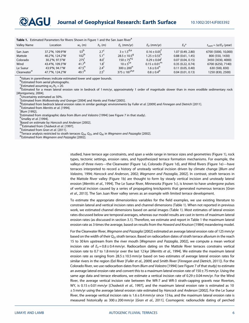
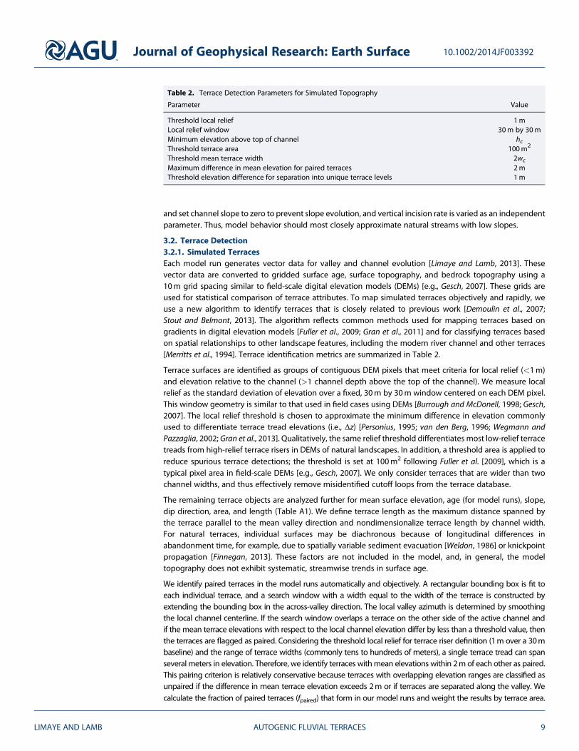
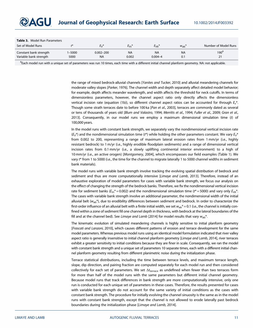
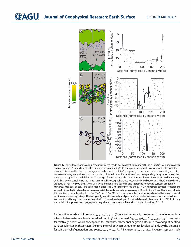
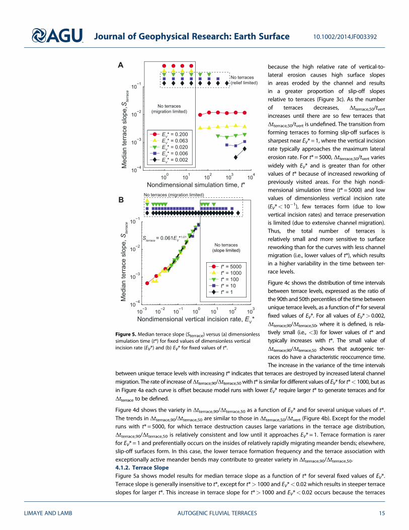
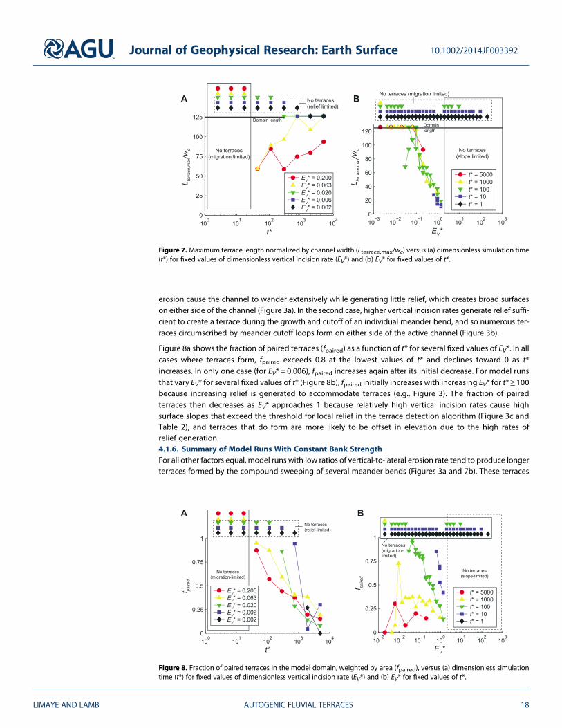
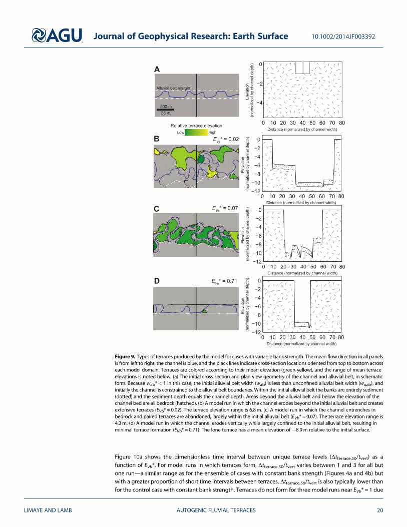
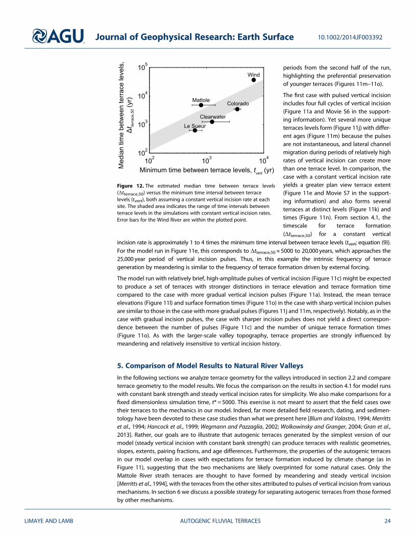