Embed Size (px)
Citation preview
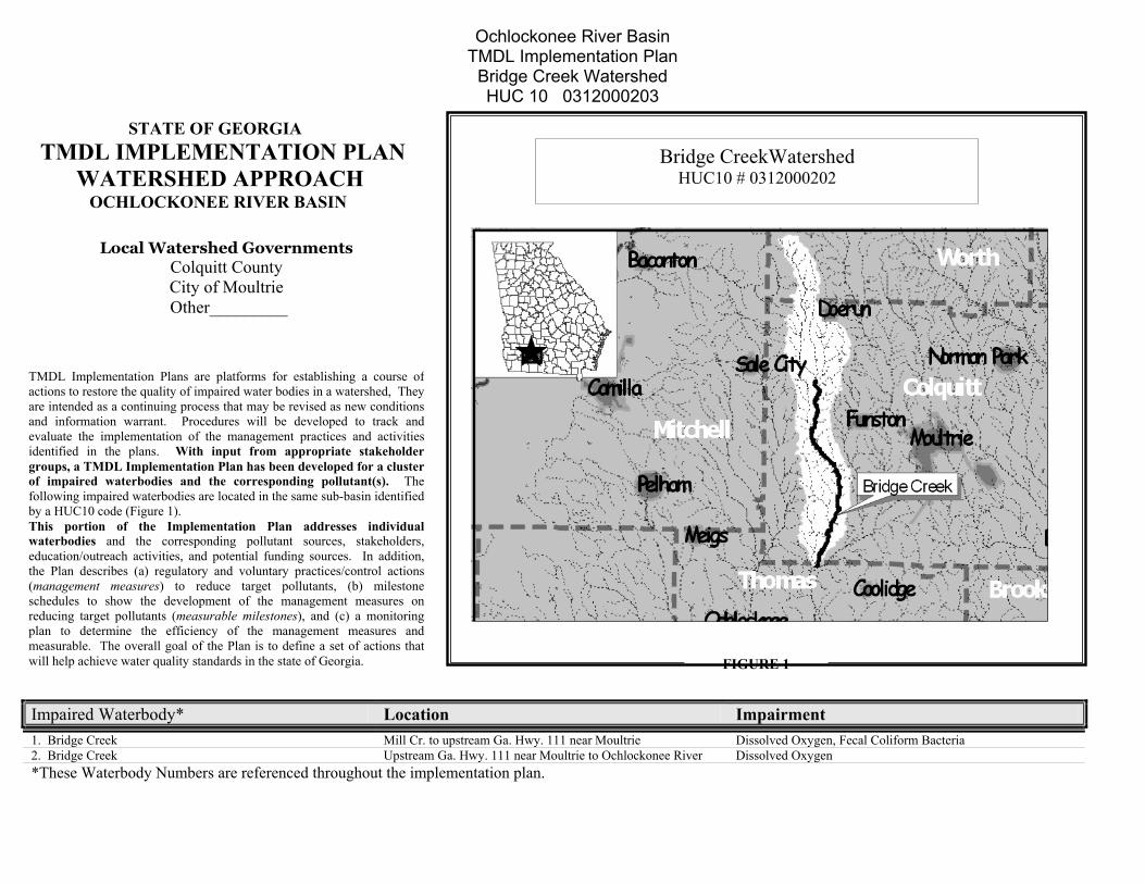
Ochlockonee River Basin TMDL Implementation Plan
Bridge Creek Watershed HUC 10 0312000203
1. Bridge Creek 2. Bridge Creek
Impaired Water
Bridge CreekWatershed HUC10 # 0312000202
Local Watershed Governments Colquitt County City of Moultrie
Other_________
STATE OF GEORGIA TMDL IMPLEMENTATION PLAN WATERSHED APPROACH OCHLOCKONEE RIVER BASIN
TMDL Implementati Plans are platforms for establishing a course ofactions to restore the q ality of impaired water bodies in a watershed, Theyare intended as a cont uing process that may be revised as new conditionsand information war nt. Procedures will be developed to track andevaluate the impleme tation of the management practices and activitiesidentified in the pla s. With input from appropriate stakeholdergroups, a TMDL Im ementation Plan has been developed for a clusterof impaired waterb dies and the corresponding pollutant(s). Thefollowing impaired wby a HUC10 code (FiThis portion of twaterbodies and theducation/outreach acthe Plan describes (a(management measuschedules to show treducing target polluplan to determine measurable. The ovewill help achieve wate
*These Waterbod
onuinrannplo
Mill Cr. to upstream Ga. Hwy. 111 near Moultrie Dissolved Oxygen, Fecal Coliform Bacteria Upstream Ga. Hwy. 111 near Moultrie to Ochlockonee River Dissolved Oxygen
body* Location Impairment
FIGURE 1
aterbodies are located in the same sub-basin identifiedgure 1). he Implementation Plan addresses individuale corresponding pollutant sources, stakeholders,tivities, and potential funding sources. In addition,) regulatory and voluntary practices/control actionsres) to reduce target pollutants, (b) milestonehe development of the management measures ontants (measurable milestones), and (c) a monitoringthe efficiency of the management measures andrall goal of the Plan is to define a set of actions thatr quality standards in the state of Georgia.
y Numbers are referenced throughout the implementation plan.
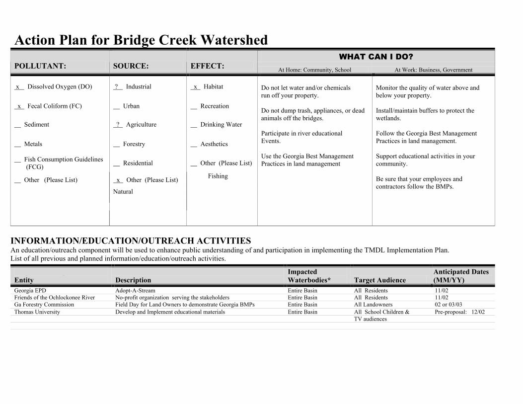
Action Plan for Bridge Creek Watershed
WHAT CAN I DO? POLLUTANT: SOURCE: EFFECT: At Home: Community, School At Work: Business, Government
x Dissolved Oxygen (DO) ? Industrial x Habitat
x Fecal Coliform (FC) Urban Recreation
Sediment ? Agriculture Drinking Water
Metals Forestry Aesthetics
Fish Consumption Guidelines (FCG) Residential Other (Please List)
Fishing Other (Please List) x Other (Please List) Natural
Do not let water and/or chemicals run off your property. Do not dump trash, appliances, or dead animals off the bridges. Participate in river educational Events. Use the Georgia Best Management Practices in land management
Monitor the quality of water above and below your property. Install/maintain buffers to protect the wetlands. Follow the Georgia Best Management Practices in land management. Support educational activities in your community. Be sure that your employees and contractors follow the BMPs.
INFORMATION/EDUCATION/OUTREACH ACTIVITIES An education/outreach component will be used to enhance public understanding of and participation in implementing the TMDL Implementation Plan. List of all previous and planned information/education/outreach activities.
Responsible Organization Or Entity Description
Impacted Waterbodies* Target Audience
Anticipated Dates (MM/YY)
Georgia EPD Adopt-A-Stream Entire Basin All Residents 11/02 Friends of the Ochlockonee River No-profit organization serving the stakeholders Entire Basin All Residents 11/02 Ga Forestry Commission Field Day for Land Owners to demonstrate Georgia BMPs Entire Basin All Landowners 02 or 03/03 Thomas University Develop and Implement educational materials Entire Basin All School Children & Pre-proposal: 12/02
TV audiences
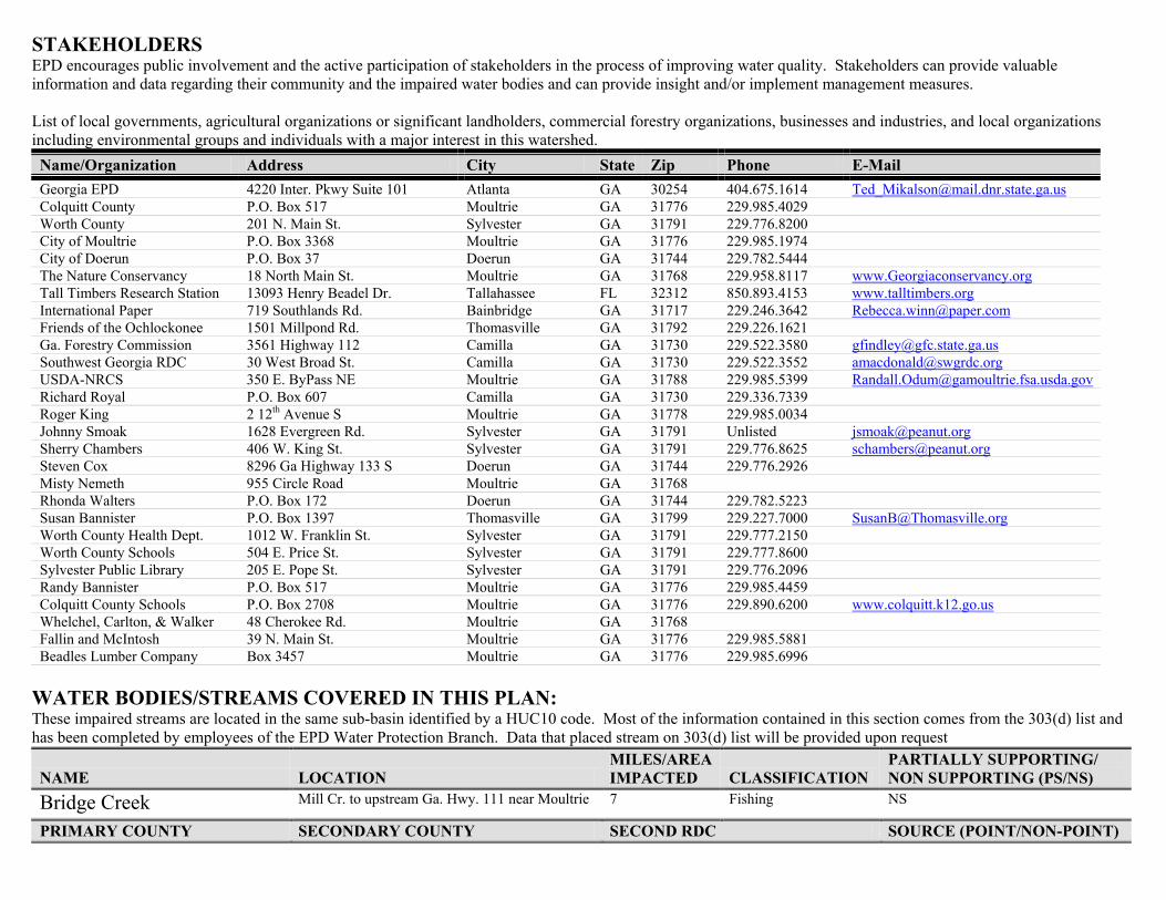
STAKEHOLDERS EPD encourages public involvement and the active participation of stakeholders in the process of improving water quality. Stakeholders can provide valuable information and data regarding their community and the impaired water bodies and can provide insight and/or implement management measures. List of local governments, agricultural organizations or significant landholders, commercial forestry organizations, businesses and industries, and local organizations including environmental groups and individuals with a major interest in this watershed. Name/Organization Address City State Zip Phone E-Mail Georgia EPD 4220 Inter. Pkwy Suite 101 Atlanta GA 30254 404.675.1614 [email protected] Colquitt County P.O. Box 517 Moultrie GA 31776 229.985.4029 Worth County 201 N. Main St. Sylvester GA 31791 229.776.8200 City of Moultrie P.O. Box 3368 Moultrie GA 31776 229.985.1974 City of Doerun P.O. Box 37 Doerun GA 31744 229.782.5444 The Nature Conservancy 18 North Main St. Moultrie GA 31768 229.958.8117 www.Georgiaconservancy.org Tall Timbers Research Station 13093 Henry Beadel Dr. Tallahassee FL 32312 850.893.4153 www.talltimbers.org International Paper 719 Southlands Rd. Bainbridge GA 31717 229.246.3642 [email protected] Friends of the Ochlockonee 1501 Millpond Rd. Thomasville GA 31792 229.226.1621 Ga. Forestry Commission 3561 Highway 112 Camilla GA 31730 229.522.3580 [email protected] Southwest Georgia RDC 30 West Broad St. Camilla GA 31730 229.522.3552 [email protected] USDA-NRCS 350 E. ByPass NE Moultrie GA 31788 229.985.5399 [email protected] Richard Royal P.O. Box 607 Camilla GA 31730 229.336.7339 Roger King 2 12th Avenue S Moultrie GA 31778 229.985.0034 Johnny Smoak 1628 Evergreen Rd. Sylvester GA 31791 Unlisted [email protected] Sherry Chambers 406 W. King St. Sylvester GA 31791 229.776.8625 [email protected] Steven Cox 8296 Ga Highway 133 S Doerun GA 31744 229.776.2926 Misty Nemeth 955 Circle Road Moultrie GA 31768 Rhonda Walters P.O. Box 172 Doerun GA 31744 229.782.5223 Susan Bannister P.O. Box 1397 Thomasville GA 31799 229.227.7000 [email protected] Worth County Health Dept. 1012 W. Franklin St. Sylvester GA 31791 229.777.2150 Worth County Schools 504 E. Price St. Sylvester GA 31791 229.777.8600 Sylvester Public Library 205 E. Pope St. Sylvester GA 31791 229.776.2096 Randy Bannister P.O. Box 517 Moultrie GA 31776 229.985.4459 Colquitt County Schools P.O. Box 2708 Moultrie GA 31776 229.890.6200 www.colquitt.k12.go.us Whelchel, Carlton, & Walker 48 Cherokee Rd. Moultrie GA 31768 Fallin and McIntosh 39 N. Main St. Moultrie GA 31776 229.985.5881 Beadles Lumber Company Box 3457 Moultrie GA 31776 229.985.6996
WATER BODIES/STREAMS COVERED IN THIS PLAN: These impaired streams are located in the same sub-basin identified by a HUC10 code. Most of the information contained in this section comes from the 303(d) list and has been completed by employees of the EPD Water Protection Branch. Data that placed stream on 303(d) list will be provided upon request
NAME LOCATION MILES/AREA IMPACTED CLASSIFICATION
PARTIALLY SUPPORTING/ NON SUPPORTING (PS/NS)
Bridge Creek Mill Cr. to upstream Ga. Hwy. 111 near Moultrie 7 Fishing NS
PRIMARY COUNTY SECONDARY COUNTY SECOND RDC SOURCE (POINT/NON-POINT)
Colquitt Nonpoint
POLLUTANTS WATER QUALITY STANDARDS REQUIRED REDUCTION TMDL ID #
DATE TMDL ESTABLISHED
Dissolved Oxygen 5mg/l (daily average) 4 mg/l (minimum) Natural DO lower than state standard. Calculated DO 2.66 mg/l.
42% TOC (lb/yr) 42% TN (lb/yr) 42% TP (lb/yr)
12/2001
Fecal Coliform Bacteria
1,000 per 100 ml (geometric mean Nov-April) 200 per 100 ml (geometric mean May-Oct)
77% 6/2000
NAME LOCATION MILES/AREA IMPACTED CLASSIFICATION
PARTIALLY SUPPORTING/ NON SUPPORTING (PS/NS)
Bridge Creek Upstream Ga. Hwy. 111 near Moultrie to Ochlockonee River
10 Fishing NS
PRIMARY COUNTY SECONDARY COUNTY SECOND RDC SOURCE (POINT/NON-POINT) Colquitt Nonpoint
POLLUTANTS WATER QUALITY STANDARDS REQUIRED REDUCTION TMDL ID #
DATE TMDL ESTABLISHED
Dissolved Oxygen 5mg/l (daily average) 4 mg/l (minimum) Natural DO lower than state standard. Calculated target DO 3.29 mg/l.
41% TOC (lb/yr) 41% TN (lb/yr) 41% TP (lb/yr)
12/2001
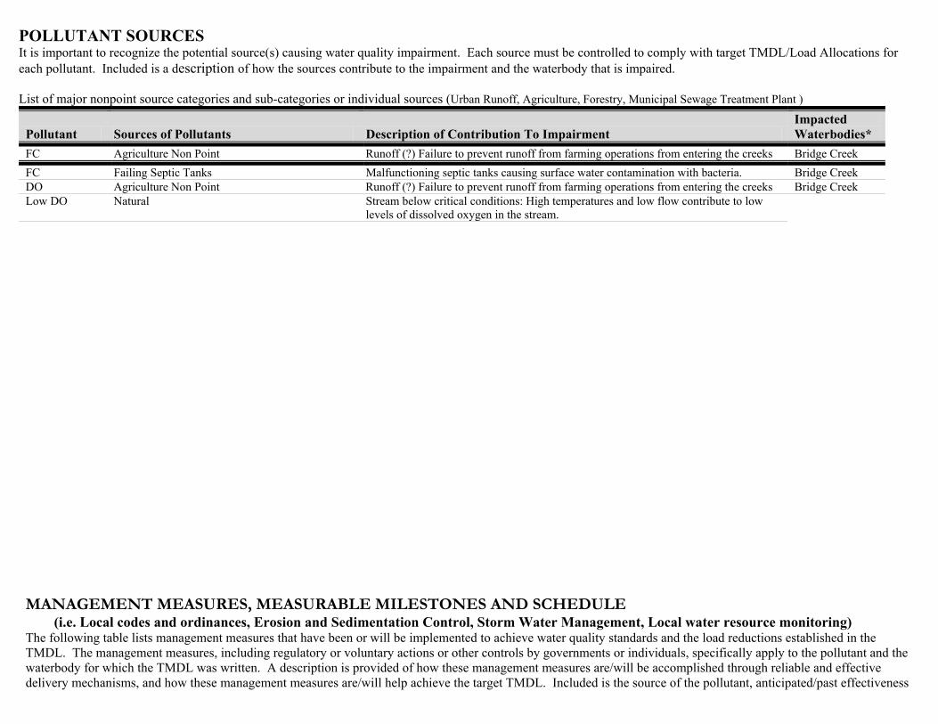
POLLUTANT SOURCES It is important to recognize the potential source(s) causing water quality impairment. Each source must be controlled to comply with target TMDL/Load Allocations for each pollutant. Included is a description of how the sources contribute to the impairment and the waterbody that is impaired. List of major nonpoint source categories and sub-categories or individual sources (Urban Runoff, Agriculture, Forestry, Municipal Sewage Treatment Plant )
Pollutant Sources of Pollutants Description of Contribution To Impairment Impacted Waterbodies*
FC Agriculture Non Point Runoff (?) Failure to prevent runoff from farming operations from entering the creeks Bridge Creek FC Failing Septic Tanks Malfunctioning septic tanks causing surface water contamination with bacteria. Bridge Creek DO Agriculture Non Point Runoff (?) Failure to prevent runoff from farming operations from entering the creeks Bridge Creek Low DO Natural Stream below critical conditions: High temperatures and low flow contribute to low
levels of dissolved oxygen in the stream. MANAGEMENT MEASURES, MEASURABLE MILESTONES AND SCHEDULE (i.e. Local codes and ordinances, Erosion and Sedimentation Control, Storm Water Management, Local water resource monitoring) The following table lists management measures that have been or will be implemented to achieve water quality standards and the load reductions established in the TMDL. The management measures, including regulatory or voluntary actions or other controls by governments or individuals, specifically apply to the pollutant and the waterbody for which the TMDL was written. A description is provided of how these management measures are/will be accomplished through reliable and effective delivery mechanisms, and how these management measures are/will help achieve the target TMDL. Included is the source of the pollutant, anticipated/past effectiveness
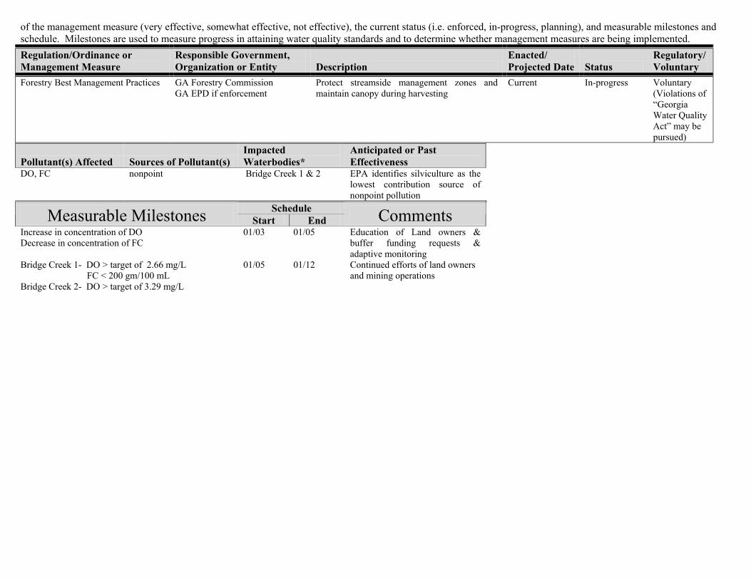
of the management measure (very effective, somewhat effective, not effective), the current status (i.e. enforced, in-progress, planning), and measurable milestones and schedule. Milestones are used to measure progress in attaining water quality standards and to determine whether management measures are being implemented. Regulation/Ordinance or Management Measure
Responsible Government, Organization or Entity Description
Enacted/ Projected Date Status
Regulatory/Voluntary
Forestry Best Management Practices GA Forestry Commission GA EPD if enforcement
Protect streamside management zones and maintain canopy during harvesting
Current In-progress
Voluntary (Violations of “Georgia Water Quality Act” may be pursued)
Pollutant(s) Affected Sources of Pollutant(s) Impacted Waterbodies*
Anticipated or Past Effectiveness
DO, FC nonpoint Bridge Creek 1 & 2 EPA identifies silviculture as the lowest contribution source of nonpoint pollution
Schedule Measurable Milestones Start End Comments Increase in concentration of DO Decrease in concentration of FC
01/03 01/05 Education of Land owners & buffer funding requests & adaptive monitoring
Bridge Creek 1- DO > target of 2.66 mg/L 01/05 01/12 Continued efforts of land owners FC < 200 gm/100 mL and mining operations Bridge Creek 2- DO > target of 3.29 mg/L
Regulation/Ordinance or Management Measure
Responsible Government, Organization or Entity Description
Enacted/ Projected Date Status Regulatory/Voluntary
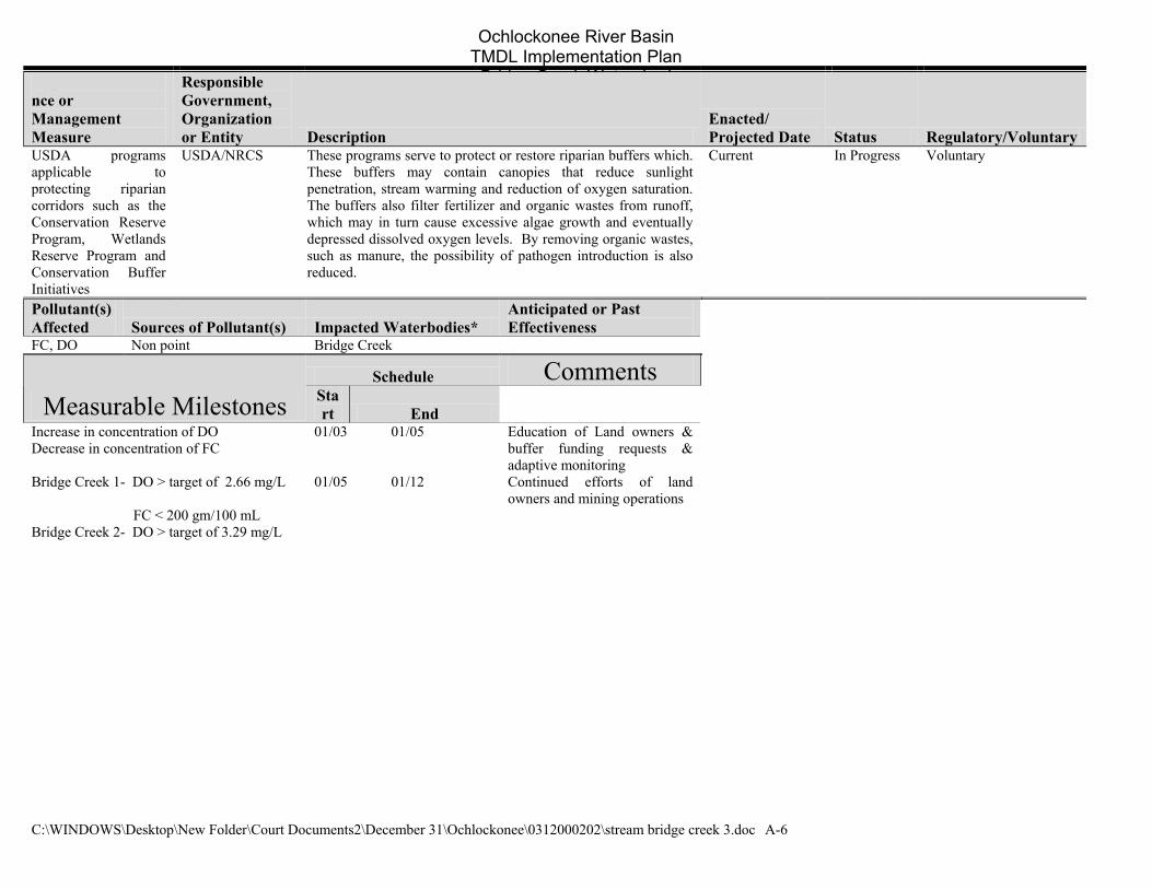
USDA programsapplicable to protecting riparian corridors such as the Conservation Reserve Program, Wetlands Reserve Program and Conservation Buffer Initiatives
USDA/NRCS These programs serve to protect or restore riparian buffers which. These buffers may contain canopies that reduce sunlight penetration, stream warming and reduction of oxygen saturation. The buffers also filter fertilizer and organic wastes from runoff, which may in turn cause excessive algae growth and eventually depressed dissolved oxygen levels. By removing organic wastes, such as manure, the possibility of pathogen introduction is also reduced.
Current In Progress Voluntary
Pollutant(s) Affected Sources of Pollutant(s) Impacted Waterbodies*
Anticipated or Past Effectiveness
FC, DO Non point Aucilla R & Olive Ck
Schedule Comments Measurable Milestones Sta
rt End
Increase in concentration of DO Decrease in concentration of FC
01/03 01/05 Education of Land owners & buffer funding requests & adaptive monitoring
Bridge Creek 1- DO > target of 2.66 mg/L 01/05 01/12 Continued efforts of land owners and mining operations
FC < 200 gm/100 mL Bridge Creek 2- DO > target of 3.29 mg/L
Regulation/Ordinance or Management Measure
Responsible Government, Organization or Entity Description
Enacted/ Projected Date Status
Regulatory/Voluntary
Reduce Dumping off bridges Colquitt & Worth Counties Reduce trash and carcasses being dumped into the river tributaries-Education and Enforcement programs
Thomas Cty- 10/02 Grady &Mitchell Cty ?/?
proposed
In progress
Regulatory
Pollutant(s) Affected Sources of Pollutant(s) Impacted Waterbodies*
Anticipated or Past Effectiveness
DO, FC Oils, greases, carcasses Bridge Creek 1 & 2 Not effective Schedule Measurable Milestones Start End Comments
Reduction of trash observed 01/03 01/05 Educational programs, signs. monitoring via photography
Continued reduction of trash observed
01/05 01/12 Continue above actions
Regulation/Ordinance or Management Measure
Responsible Government, Organization or Entity Description
Enacted/ Projected Date Status
Regulatory/Voluntary
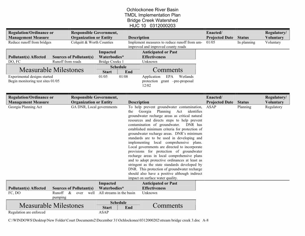
Reduce runoff from bridges Colquitt & Worth Counties Implement measures to reduce runoff from um-improved and improved county roads
01/05 In planning Voluntary
Pollutant(s) Affected Sources of Pollutant(s) Impacted Waterbodies*
Anticipated or Past Effectiveness
DO, FC Runoff from roads Bridge Creeks 1 & 2 Unknown Schedule Measurable Milestones Start End Comments
Experimental designs started Begin monitoring test sites 01/05
01/05 01/08 Application EPA Wetlands protection grant –pre-proposal 12/02
Regulation/Ordinance or Management Measure
Responsible Government, Organization or Entity Description
Enacted/ Projected Date Status
Regulatory/Voluntary
Georgia Planning Act GA DNR, Local governments To help prevent groundwater contamination, the Georgia Planning Act identifies groundwater recharge areas as critical natural resources and directs steps to help prevent contamination of groundwater. DNR has established minimum criteria for protection of groundwater recharge areas. DNR’s minimum standards are to be used in developing and implementing local comprehensive plans. Local governments are directed to incorporate provisions for protection of groundwater recharge areas in local comprehensive plans and to adopt protective ordinances at least as stringent as the state standards developed by DNR. This protection of groundwater recharge should also have a positive although indirect impact on surface water quality.
ASAP Planning Regulatory
Pollutant(s) Affected Sources of Pollutant(s) Impacted Waterbodies*
Anticipated or Past Effectiveness
FC, DO Runoff & over well pumping
All streams in the basin Unknown
Schedule Measurable Milestones Start End Comments Regulation are enforced ASAP
Regulation/Ordinance or Management Measure
Responsible Government, Organization or Entity Description
Enacted/ Projected Date Status
Regulatory/Voluntary
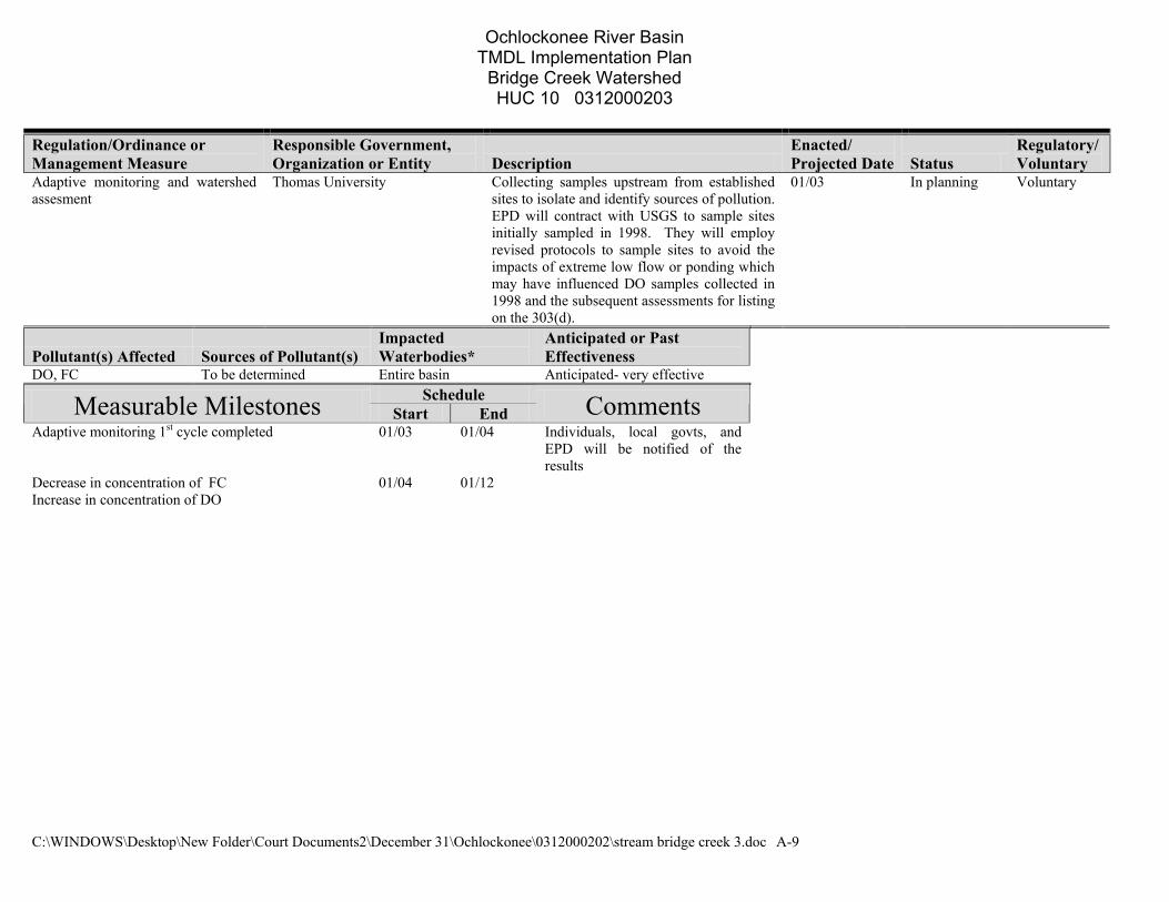
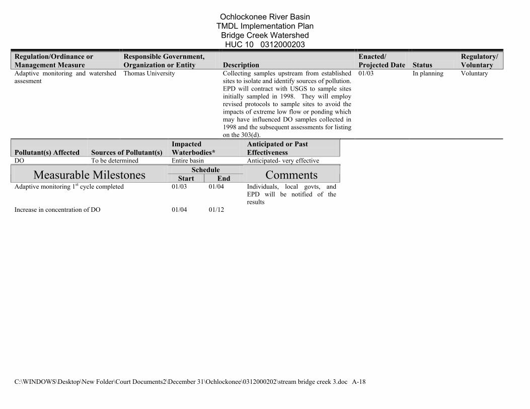
Adaptive monitoring and watershed assesment
Thomas University Collecting samples upstream from established sites to isolate and identify sources of pollution. EPD will contract with USGS to sample sites initially sampled in 1998. They will employ revised protocols to sample sites to avoid the impacts of extreme low flow or ponding which may have influenced DO samples collected in 1998 and the subsequent assessments for listing on the 303(d).
01/03 In planning Voluntary
Pollutant(s) Affected Sources of Pollutant(s) Impacted Waterbodies*
Anticipated or Past Effectiveness
DO, FC To be determined Entire basin Anticipated- very effective Schedule Measurable Milestones Start End Comments
Adaptive monitoring 1st cycle completed 01/03 01/04 Individuals, local govts, and EPD will be notified of the results
Decrease in concentration of FC Increase in concentration of DO
01/04 01/12
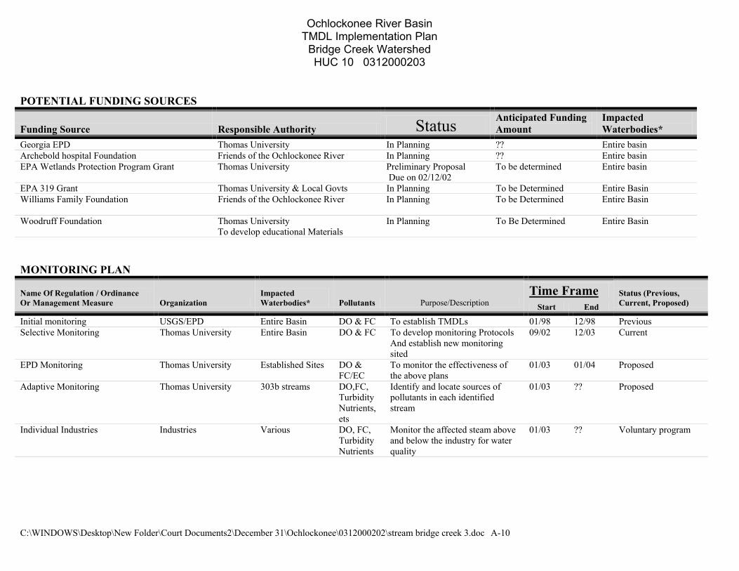
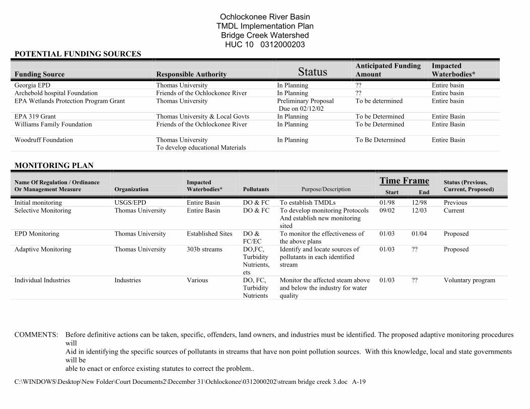
POTENTIAL FUNDING SOURCES The identification and discussion of dedicated funding is important in determining the economic feasibility of the above-mentioned management measures
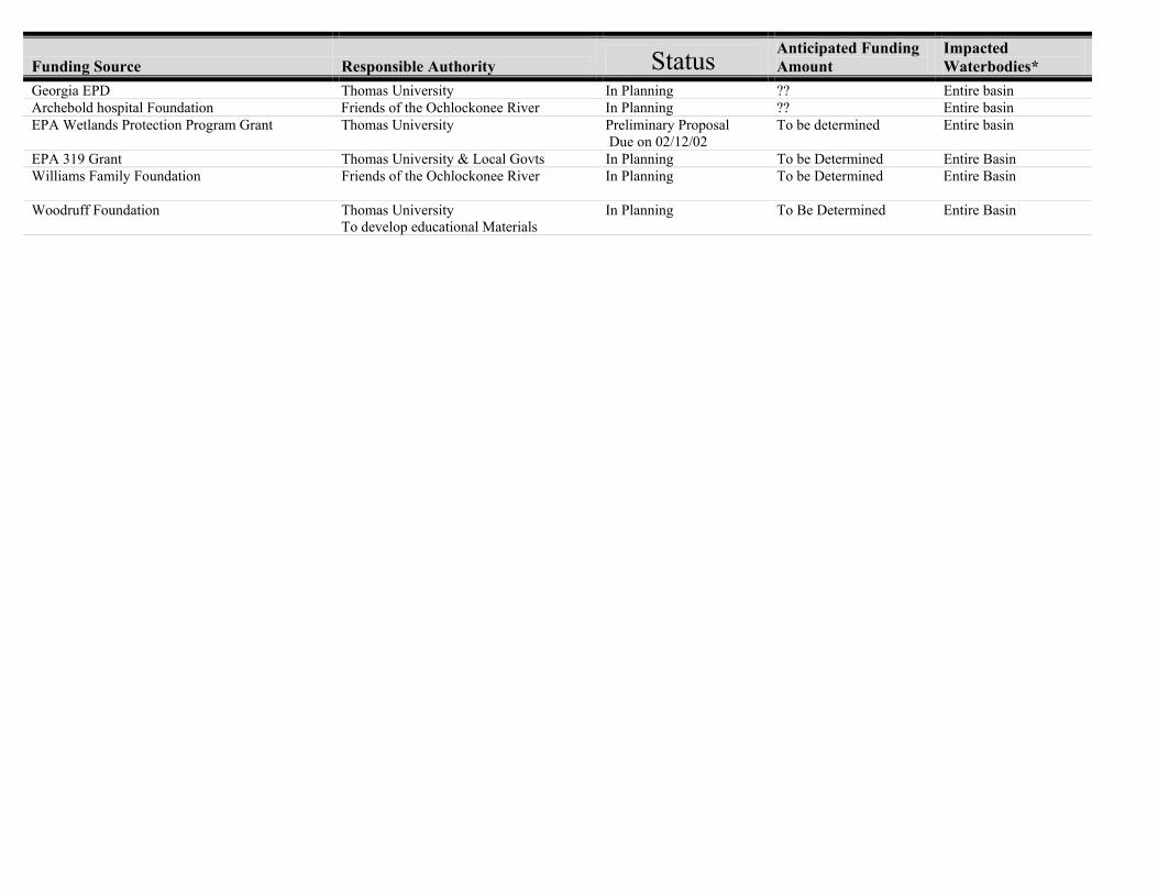
Funding Source Responsible Authority Status Anticipated Funding Amount
Impacted Waterbodies*
Georgia EPD Thomas University In Planning ?? Entire basin Archebold hospital Foundation Friends of the Ochlockonee River In Planning ?? Entire basin EPA Wetlands Protection Program Grant Thomas University Preliminary Proposal
Due on 02/12/02 To be determined Entire basin
EPA 319 Grant Thomas University & Local Govts In Planning To be Determined Entire Basin Williams Family Foundation Friends of the Ochlockonee River
In Planning To be Determined Entire Basin
Woodruff Foundation Thomas University To develop educational Materials
In Planning To Be Determined Entire Basin
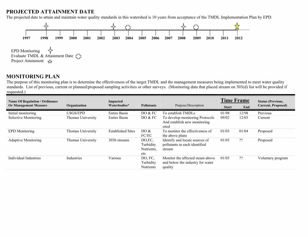
PROJECTED ATTAINMENT DATE The projected date to attain and maintain water quality standards in this watershed is 10 years from acceptance of the TMDL Implementation Plan by EPD.
1997 1998 1999 2000 2001 2002 2003 2004 2005 2006 2007 2008 2009 2010 2011 2012
EPD Monitoring Evaluate TMDL & Attainment Date Project Attainment
MONITORING PLAN The purpose of this monitoring plan is to determine the effectiveness of the target TMDL and the management measures being implemented to meet water quality standards. List of previous, current or planned/proposed sampling activities or other surveys. (Monitoring data that placed stream on 303(d) list will be provided if requested.)
Time Frame Name Of Regulation / Ordinance Or Management Measure Organization
Impacted Waterbodies* Pollutants Purpose/Description Start End
Status (Previous, Current, Proposed)
Initial monitoring USGS/EPD Entire Basin DO & FC To establish TMDLs 01/98 12/98 Previous Selective Monitoring Thomas University Entire Basin DO & FC To develop monitoring Protocols
And establish new monitoring sited
09/02 12/03 Current
EPD Monitoring Thomas University Established Sites DO & FC/EC
To monitor the effectiveness of the above plans
01/03 01/04 Proposed
Adaptive Monitoring Thomas University 303b streams DO,FC, Turbidity Nutrients, ets
Identify and locate sources of pollutants in each identified stream
01/03 ?? Proposed
Individual Industries Industries Various DO, FC, Turbidity Nutrients
Monitor the affected steam above and below the industry for water quality
01/03 ?? Voluntary program
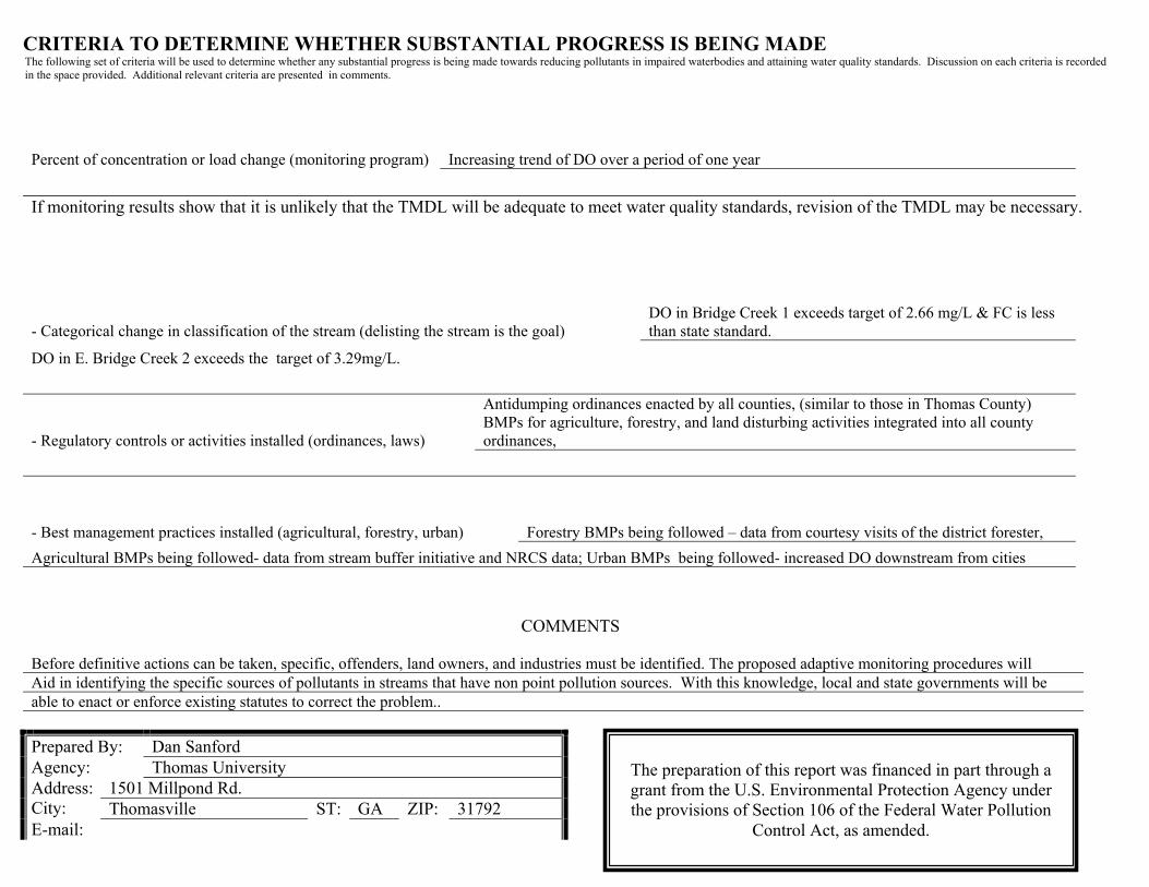
CRITERIA TO DETERMINE WHETHER SUBSTANTIAL PROGRESS IS BEING MADE The following set of criteria will be used to determine whether any substantial progress is being made towards reducing pollutants in impaired waterbodies and attaining water quality standards. Discussion on each criteria is recorded in the space provided. Additional relevant criteria are presented in comments.
Percent of concentration or load change (monitoring program) Increasing trend of DO over a period of one year
If monitoring results show that it is unlikely that the TMDL will be adequate to meet water quality standards, revision of the TMDL may be necessary.
- Regulatory controls or activities installed (ordinances, laws)
Antidumping ordinances enacted by all counties, (similar to those in Thomas County) BMPs for agriculture, forestry, and land disturbing activities integrated into all county ordinances,
- Best management practices installed (agricultural, forestry, urban) Forestry BMPs being followed – data from courtesy visits of the district forester, Agricultural BMPs being followed- data from stream buffer initiative and NRCS data; Urban BMPs being followed- increased DO downstream from cities
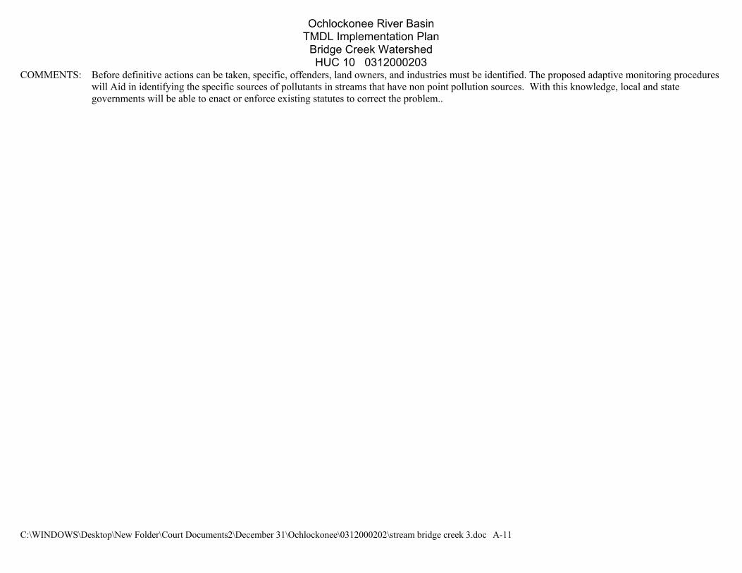
COMMENTS
Before definitive actions can be taken, specific, offenders, land owners, and industries must be identified. The proposed adaptive monitoring procedures will Aid in identifying the specific sources of pollutants in streams that have non point pollution sources. With this knowledge, local and state governments will be able to enact or enforce existing statutes to correct the problem..
Prepared By: Dan Sanford Agency: Thomas University
1501 Millpond Rd. Address: City: Thomasville ST: GA ZIP: 31792E-mail:
- Categorical change in classification of the stream (delisting the stream is the goal) DO in Bridge Creek 1 exceeds target of 2.66 mg/L & FC is less than state standard.
DO in E. Bridge Creek 2 exceeds the target of 3.29mg/L.
The preparation of this report was financed in part through a grant from the U.S. Environmental Protection Agency under the provisions of Section 106 of the Federal Water Pollution
Control Act, as amended.
TOGETHER WE CAN MAKE A DIFFERENCE!
Environmental Protection Division of the Department of Natural Resources, State of Georgia.
Date Submitted to EPD: 12/19/02 as per EPD modifications
ATTACHMENT A:
STREAM APPROACH

C:\WINDOWS\Desktop\New Folder\Court Documents2\D
1. Bridge Creek 2. Bridge Creek
Impaired Waterbody*
Bridge Creek Watershed HUC10 # 0313000202
STREAM APPROACH
STATE OF GEORGIA TMDL IMPLEMENTATION PLAN OCHLOCKONEE RIVER BASIN
TMDL Implementation Plans are platforms for establishing aactions to restore the quality of impaired water bodies in a watersare intended as a continuing process that may be revised as newand information warrant. Procedures will be developed toevaluate the implementation of the management practices anidentified in the plans. With input from appropriate stakeholdeTMDL Implementation Plan has been developed for a cluster owaterbodies and the corresponding pollutant(s). The followinwaterbodies are located in the same sub-basin identified by a H(Figure 1). This portion of the Implementation Plan addresses waterbodies and the corresponding pollutant sources, steducation/outreach activities, and potential funding sources. Ithe Plan describes (a) regulatory and voluntary practices/cont(management measures) to reduce target pollutants, (b) schedules to show the development of the management mreducing target pollutants (measurable milestones), and (c) a plan to determine the efficiency of the management meameasurable. The overall goal of the Plan is to define a set of awill help achieve water quality standards in the state of Georgia.
*These Waterbody Numbers are referenced througho
dr
gU
ianr
em
ecember 31\Ochlockonee\0312000202\stream bridge creek 3.doc A-1
Mill Cr. to upstream Ga. Hwy. 111 near Moultrie Dissolved Oxygen, Fecal Coliform Bacteria Upstream Ga. Hwy. 111 near Moultrie to Ochlockonee River Dissolved Oxygen
Location Impairment
FIGURE 1
course ofhed, Theyconditionstrack and activities groups, af impaired impairedC10 code
ndividualkeholders, addition,ol actionsmilestoneasures ononitoring
sures andctions that
ut the implementation plan.
Ochlockonee River Basin TMDL Implementation Plan
Bridge Creek Watershed HUC 10 0312000203
C:\WINDOWS\Desktop\New Folder\Court Documents2\December 31\Ochlockonee\0312000202\stream bridge creek 3.doc A-2
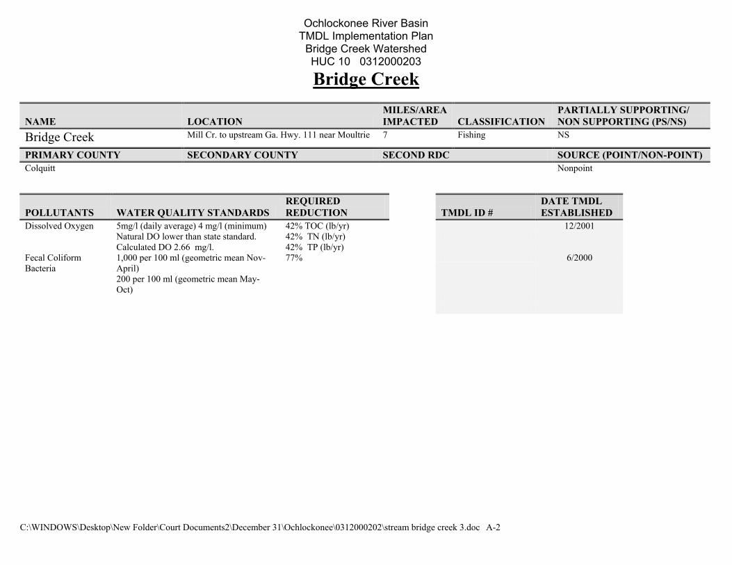
Bridge Creek
NAME LOCATION MILES/AREA IMPACTED CLASSIFICATION
PARTIALLY SUPPORTING/ NON SUPPORTING (PS/NS)
Bridge Creek Mill Cr. to upstream Ga. Hwy. 111 near Moultrie 7 Fishing NS
PRIMARY COUNTY SECONDARY COUNTY SECOND RDC SOURCE (POINT/NON-POINT) Colquitt Nonpoint
POLLUTANTS WATER QUALITY STANDARDS REQUIRED REDUCTION TMDL ID #
DATE TMDL ESTABLISHED
Dissolved Oxygen 5mg/l (daily average) 4 mg/l (minimum) Natural DO lower than state standard. Calculated DO 2.66 mg/l.
42% TOC (lb/yr) 42% TN (lb/yr) 42% TP (lb/yr)
12/2001
Fecal Coliform Bacteria
1,000 per 100 ml (geometric mean Nov-April) 200 per 100 ml (geometric mean May-Oct)
77% 6/2000

Ochlockonee River Basin TMDL Implementation Plan
Bridge Creek Watershed HUC 10 0312000203
C:\WINDOWS\Desktop\New Folder\Court Documents2\December 31\Ochlockonee\0312000202\stream bridge creek 3.doc A-3
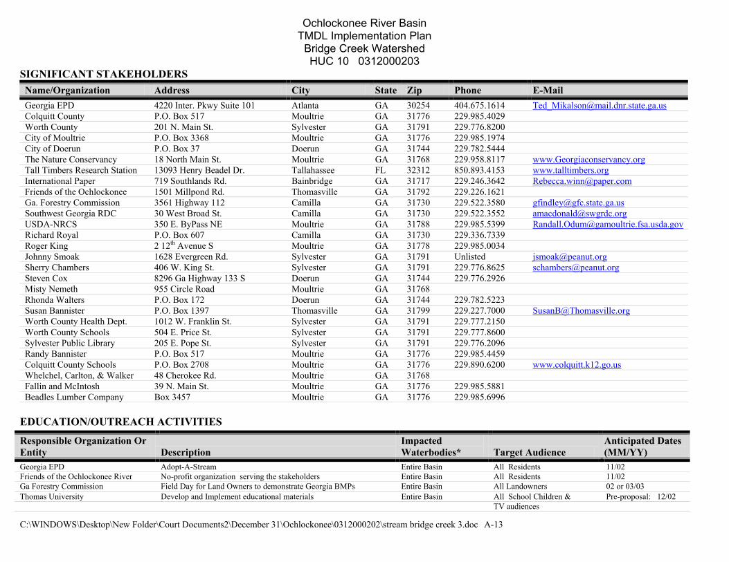
SIGNIFICANT STAKEHOLDERS Name/Organization Address City State Zip Phone E-Mail Georgia EPD 4220 Inter. Pkwy Suite 101 Atlanta GA 30254 404.675.1614 [email protected] Colquitt County P.O. Box 517 Moultrie GA 31776 229.985.4029 Worth County 201 N. Main St. Sylvester GA 31791 229.776.8200 City of Moultrie P.O. Box 3368 Moultrie GA 31776 229.985.1974 City of Doerun P.O. Box 37 Doerun GA 31744 229.782.5444 The Nature Conservancy 18 North Main St. Moultrie GA 31768 229.958.8117 www.Georgiaconservancy.org Tall Timbers Research Station 13093 Henry Beadel Dr. Tallahassee FL 32312 850.893.4153 www.talltimbers.org International Paper 719 Southlands Rd. Bainbridge GA 31717 229.246.3642 [email protected] Friends of the Ochlockonee 1501 Millpond Rd. Thomasville GA 31792 229.226.1621 Ga. Forestry Commission 3561 Highway 112 Camilla GA 31730 229.522.3580 [email protected] Southwest Georgia RDC 30 West Broad St. Camilla GA 31730 229.522.3552 [email protected] USDA-NRCS 350 E. ByPass NE Moultrie GA 31788 229.985.5399 [email protected] Richard Royal P.O. Box 607 Camilla GA 31730 229.336.7339 Roger King 2 12th Avenue S Moultrie GA 31778 229.985.0034 Johnny Smoak 1628 Evergreen Rd. Sylvester GA 31791 Unlisted [email protected] Sherry Chambers 406 W. King St. Sylvester GA 31791 229.776.8625 [email protected] Steven Cox 8296 Ga Highway 133 S Doerun GA 31744 229.776.2926 Misty Nemeth 955 Circle Road Moultrie GA 31768 Rhonda Walters P.O. Box 172 Doerun GA 31744 229.782.5223 Susan Bannister P.O. Box 1397 Thomasville GA 31799 229.227.7000 [email protected] Worth County Health Dept. 1012 W. Franklin St. Sylvester GA 31791 229.777.2150 Worth County Schools 504 E. Price St. Sylvester GA 31791 229.777.8600 Sylvester Public Library 205 E. Pope St. Sylvester GA 31791 229.776.2096 Randy Bannister P.O. Box 517 Moultrie GA 31776 229.985.4459 Colquitt County Schools P.O. Box 2708 Moultrie GA 31776 229.890.6200 www.colquitt.k12.go.us Whelchel, Carlton, & Walker 48 Cherokee Rd. Moultrie GA 31768 Fallin and McIntosh 39 N. Main St. Moultrie GA 31776 229.985.5881 Beadles Lumber Company Box 3457 Moultrie GA 31776 229.985.6996
EDUCATION/OUTREACH ACTIVITIES
Responsible Organization Or Entity Description
Impacted Waterbodies* Target Audience
Anticipated Dates (MM/YY)
Georgia EPD Adopt-A-Stream Entire Basin All Residents 11/02 Friends of the Ochlockonee River No-profit organization serving the stakeholders Entire Basin All Residents 11/02 Ga Forestry Commission Field Day for Land Owners to demonstrate Georgia BMPs Entire Basin All Landowners 02 or 03/03 Thomas University Develop and Implement educational materials Entire Basin All School Children & Pre-proposal: 12/02 TV audiences
Ochlockonee River Basin TMDL Implementation Plan
Bridge Creek Watershed HUC 10 0312000203
C:\WINDOWS\Desktop\New Folder\Court Documents2\December 31\Ochlockonee\0312000202\stream bridge creek 3.doc A-4
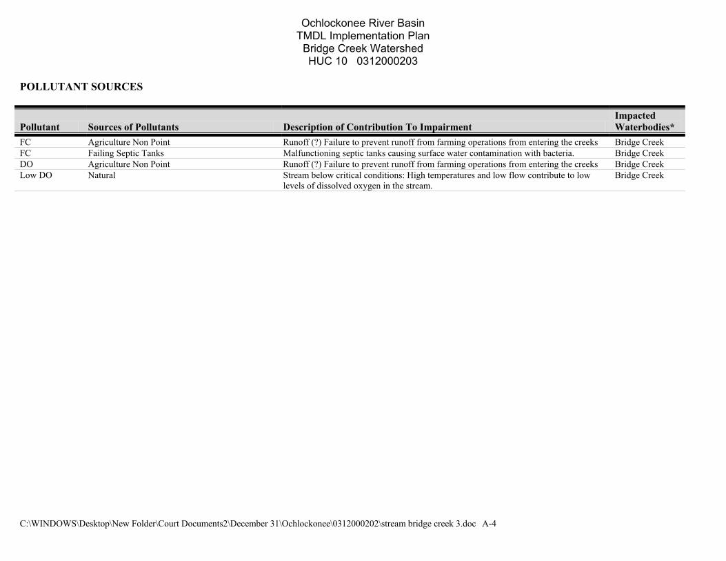
POLLUTANT SOURCES
Pollutant Sources of Pollutants Description of Contribution To Impairment Impacted Waterbodies*
FC Agriculture Non Point Runoff (?) Failure to prevent runoff from farming operations from entering the creeks Bridge Creek FC Failing Septic Tanks Malfunctioning septic tanks causing surface water contamination with bacteria. Bridge Creek DO Agriculture Non Point Runoff (?) Failure to prevent runoff from farming operations from entering the creeks Bridge Creek Low DO Natural Stream below critical conditions: High temperatures and low flow contribute to low
levels of dissolved oxygen in the stream. Bridge Creek
Ochlockonee River Basin TMDL Implementation Plan
Bridge Creek Watershed HUC 10 0312000203
C:\WINDOWS\Desktop\New Folder\Court Documents2\December 31\Ochlockonee\0312000202\stream bridge creek 3.doc A-5
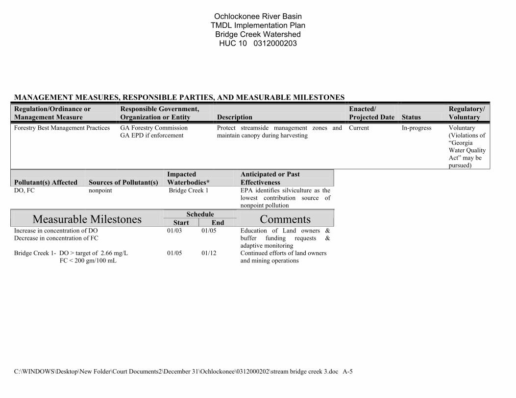
MANAGEMENT MEASURES, RESPONSIBLE PARTIES, AND MEASURABLE MILESTONES Regulation/Ordinance or Management Measure
Responsible Government, Organization or Entity Description
Enacted/ Projected Date Status
Regulatory/Voluntary
Forestry Best Management Practices GA Forestry Commission GA EPD if enforcement
Protect streamside management zones and maintain canopy during harvesting
Current In-progress
Voluntary (Violations of “Georgia Water Quality Act” may be pursued)
Pollutant(s) Affected Sources of Pollutant(s) Impacted Waterbodies*
Anticipated or Past Effectiveness
DO, FC nonpoint Bridge Creek 1 EPA identifies silviculture as the lowest contribution source of nonpoint pollution
Schedule Measurable Milestones Start End Comments Increase in concentration of DO Decrease in concentration of FC
01/03 01/05 Education of Land owners & buffer funding requests & adaptive monitoring
Bridge Creek 1- DO > target of 2.66 mg/L 01/05 01/12 Continued efforts of land owners FC < 200 gm/100 mL and mining operations
Ochlockonee River Basin TMDL Implementation Plan
Bridge Creek Watershed HUC 10 0312000203
C:\WINDOWS\Desktop\New Folder\Court Documents2\December 31\Ochlockonee\0312000202\stream bridge creek 3.doc A-6
Regulation/Ordinance or Management Measure
Responsible Government, Organization or Entity Description
Enacted/ Projected Date Status Regulatory/Voluntary
USDA programsapplicable to protecting riparian corridors such as the Conservation Reserve Program, Wetlands Reserve Program and Conservation Buffer Initiatives
USDA/NRCS These programs serve to protect or restore riparian buffers which. These buffers may contain canopies that reduce sunlight penetration, stream warming and reduction of oxygen saturation. The buffers also filter fertilizer and organic wastes from runoff, which may in turn cause excessive algae growth and eventually depressed dissolved oxygen levels. By removing organic wastes, such as manure, the possibility of pathogen introduction is also reduced.
Current In Progress Voluntary
Pollutant(s) Affected Sources of Pollutant(s) Impacted Waterbodies*
Anticipated or Past Effectiveness
FC, DO Non point Bridge Creek
Schedule Comments Measurable Milestones Sta
rt End
Increase in concentration of DO Decrease in concentration of FC
01/03 01/05 Education of Land owners & buffer funding requests & adaptive monitoring
Bridge Creek 1- DO > target of 2.66 mg/L 01/05 01/12 Continued efforts of land owners and mining operations
FC < 200 gm/100 mL Bridge Creek 2- DO > target of 3.29 mg/L
Ochlockonee River Basin TMDL Implementation Plan
Bridge Creek Watershed HUC 10 0312000203
C:\WINDOWS\Desktop\New Folder\Court Documents2\December 31\Ochlockonee\0312000202\stream bridge creek 3.doc A-7
Regulation/Ordinance or Management Measure
Responsible Government, Organization or Entity Description
Enacted/ Projected Date Status
Regulatory/Voluntary
Reduce Dumping off bridges Colquitt & Worth Counties Reduce trash and carcasses being dumped into the river tributaries-Education and Enforcement programs
Thomas Cty- 10/02 Grady &Mitchell Cty ?/?
proposed
In progress
Regulatory
Pollutant(s) Affected Sources of Pollutant(s) Impacted Waterbodies*
Anticipated or Past Effectiveness
DO, FC Oils, greases, carcasses Bridge Creek 1 Not effective Schedule Measurable Milestones Start End Comments
Reduction in the amount of trash observed 01/03 01/05 Educational programs, signs. monitoring via photography
Continued reduction of trash observed
01/05 01/12 Continue above actions
Ochlockonee River Basin TMDL Implementation Plan
Bridge Creek Watershed HUC 10 0312000203
C:\WINDOWS\Desktop\New Folder\Court Documents2\December 31\Ochlockonee\0312000202\stream bridge creek 3.doc A-8
Regulation/Ordinance or Management Measure
Responsible Government, Organization or Entity Description
Enacted/ Projected Date Status
Regulatory/Voluntary
Reduce runoff from bridges Colquitt & Worth Counties Implement measures to reduce runoff from um-improved and improved county roads
01/05 In planning Voluntary
Pollutant(s) Affected Sources of Pollutant(s) Impacted Waterbodies*
Anticipated or Past Effectiveness
DO, FC Runoff from roads Bridge Creeks 1 Unknown Schedule Measurable Milestones Start End Comments
Experimental designs started Begin monitoring test sites 01/05
01/05 01/08 Application EPA Wetlands protection grant –pre-proposal 12/02
Regulation/Ordinance or Management Measure
Responsible Government, Organization or Entity Description
Enacted/ Projected Date Status
Regulatory/Voluntary
Georgia Planning Act GA DNR, Local governments To help prevent groundwater contamination, the Georgia Planning Act identifies groundwater recharge areas as critical natural resources and directs steps to help prevent contamination of groundwater. DNR has established minimum criteria for protection of groundwater recharge areas. DNR’s minimum standards are to be used in developing and implementing local comprehensive plans. Local governments are directed to incorporate provisions for protection of groundwater recharge areas in local comprehensive plans and to adopt protective ordinances at least as stringent as the state standards developed by DNR. This protection of groundwater recharge should also have a positive although indirect impact on surface water quality.
ASAP Planning Regulatory
Pollutant(s) Affected Sources of Pollutant(s) Impacted Waterbodies*
Anticipated or Past Effectiveness
FC, DO Runoff & over well pumping
All streams in the basin Unknown
Schedule Measurable Milestones Start End Comments Regulation are enforced ASAP
Ochlockonee River Basin TMDL Implementation Plan
Bridge Creek Watershed HUC 10 0312000203
C:\WINDOWS\Desktop\New Folder\Court Documents2\December 31\Ochlockonee\0312000202\stream bridge creek 3.doc A-9
Regulation/Ordinance or Management Measure
Responsible Government, Organization or Entity Description
Enacted/ Projected Date Status
Regulatory/Voluntary
Adaptive monitoring and watershed assesment
Thomas University Collecting samples upstream from established sites to isolate and identify sources of pollution. EPD will contract with USGS to sample sites initially sampled in 1998. They will employ revised protocols to sample sites to avoid the impacts of extreme low flow or ponding which may have influenced DO samples collected in 1998 and the subsequent assessments for listing on the 303(d).
01/03 In planning Voluntary
Pollutant(s) Affected Sources of Pollutant(s) Impacted Waterbodies*
Anticipated or Past Effectiveness
DO, FC To be determined Entire basin Anticipated- very effective Schedule Measurable Milestones Start End Comments
Adaptive monitoring 1st cycle completed 01/03 01/04 Individuals, local govts, and EPD will be notified of the results
Decrease in concentration of FC Increase in concentration of DO
01/04 01/12
Ochlockonee River Basin TMDL Implementation Plan
Bridge Creek Watershed HUC 10 0312000203
C:\WINDOWS\Desktop\New Folder\Court Documents2\December 31\Ochlockonee\0312000202\stream bridge creek 3.doc A-10
POTENTIAL FUNDING SOURCES
Funding Source Responsible Authority Status Anticipated Funding Amount
Impacted Waterbodies*
Georgia EPD Thomas University In Planning ?? Entire basin Archebold hospital Foundation Friends of the Ochlockonee River In Planning ?? Entire basin EPA Wetlands Protection Program Grant Thomas University Preliminary Proposal
Due on 02/12/02 To be determined Entire basin
EPA 319 Grant Thomas University & Local Govts In Planning To be Determined Entire Basin Williams Family Foundation Friends of the Ochlockonee River
In Planning To be Determined Entire Basin
Woodruff Foundation Thomas University To develop educational Materials
In Planning To Be Determined Entire Basin
MONITORING PLAN
Time Frame Name Of Regulation / Ordinance Or Management Measure Organization
Impacted Waterbodies* Pollutants Purpose/Description Start End
Status (Previous, Current, Proposed)
Initial monitoring USGS/EPD Entire Basin DO & FC To establish TMDLs 01/98 12/98 Previous Selective Monitoring Thomas University Entire Basin DO & FC To develop monitoring Protocols
And establish new monitoring sited
09/02 12/03 Current
EPD Monitoring Thomas University Established Sites DO & FC/EC
To monitor the effectiveness of the above plans
01/03 01/04 Proposed
Adaptive Monitoring Thomas University 303b streams DO,FC, Turbidity Nutrients, ets
Identify and locate sources of pollutants in each identified stream
01/03 ?? Proposed
Individual Industries Industries Various DO, FC, Turbidity Nutrients
Monitor the affected steam above and below the industry for water quality
01/03 ?? Voluntary program
Ochlockonee River Basin TMDL Implementation Plan
Bridge Creek Watershed HUC 10 0312000203
C:\WINDOWS\Desktop\New Folder\Court Documents2\December 31\Ochlockonee\0312000202\stream bridge creek 3.doc A-11
COMMENTS: Before definitive actions can be taken, specific, offenders, land owners, and industries must be identified. The proposed adaptive monitoring procedures will Aid in identifying the specific sources of pollutants in streams that have non point pollution sources. With this knowledge, local and state governments will be able to enact or enforce existing statutes to correct the problem..
Ochlockonee River Basin TMDL Implementation Plan
Bridge Creek Watershed HUC 10 0312000203
C:\WINDOWS\Desktop\New Folder\Court Documents2\December 31\Ochlockonee\0312000202\stream bridge creek 3.doc A-12
Bridge Creek
NAME LOCATION MILES/AREA IMPACTED CLASSIFICATION
PARTIALLY SUPPORTING/ NON SUPPORTING (PS/NS)
Bridge Creek Upstream Ga. Hwy. 111 near Moultrie to Ochlockonee River
10 Fishing NS
PRIMARY COUNTY SECONDARY COUNTY SECOND RDC SOURCE (POINT/NON-POINT) Colquitt Nonpoint
POLLUTANTS WATER QUALITY STANDARDS REQUIRED REDUCTION TMDL ID #
DATE TMDL ESTABLISHED
Dissolved Oxygen 5mg/l (daily average) 4 mg/l (minimum) Natural DO lower than state standard. Calculated target DO 3.29 mg/l.
41% TOC (lb/yr) 41% TN (lb/yr) 41% TP (lb/yr)
12/2001
Ochlockonee River Basin TMDL Implementation Plan
Bridge Creek Watershed HUC 10 0312000203
C:\WINDOWS\Desktop\New Folder\Court Documents2\December 31\Ochlockonee\0312000202\stream bridge creek 3.doc A-13
SIGNIFICANT STAKEHOLDERS Name/Organization Address City State Zip Phone E-Mail Georgia EPD 4220 Inter. Pkwy Suite 101 Atlanta GA 30254 404.675.1614 [email protected] Colquitt County P.O. Box 517 Moultrie GA 31776 229.985.4029 Worth County 201 N. Main St. Sylvester GA 31791 229.776.8200 City of Moultrie P.O. Box 3368 Moultrie GA 31776 229.985.1974 City of Doerun P.O. Box 37 Doerun GA 31744 229.782.5444 The Nature Conservancy 18 North Main St. Moultrie GA 31768 229.958.8117 www.Georgiaconservancy.org Tall Timbers Research Station 13093 Henry Beadel Dr. Tallahassee FL 32312 850.893.4153 www.talltimbers.org International Paper 719 Southlands Rd. Bainbridge GA 31717 229.246.3642 [email protected] Friends of the Ochlockonee 1501 Millpond Rd. Thomasville GA 31792 229.226.1621 Ga. Forestry Commission 3561 Highway 112 Camilla GA 31730 229.522.3580 [email protected] Southwest Georgia RDC 30 West Broad St. Camilla GA 31730 229.522.3552 [email protected] USDA-NRCS 350 E. ByPass NE Moultrie GA 31788 229.985.5399 [email protected] Richard Royal P.O. Box 607 Camilla GA 31730 229.336.7339 Roger King 2 12th Avenue S Moultrie GA 31778 229.985.0034 Johnny Smoak 1628 Evergreen Rd. Sylvester GA 31791 Unlisted [email protected] Sherry Chambers 406 W. King St. Sylvester GA 31791 229.776.8625 [email protected] Steven Cox 8296 Ga Highway 133 S Doerun GA 31744 229.776.2926 Misty Nemeth 955 Circle Road Moultrie GA 31768 Rhonda Walters P.O. Box 172 Doerun GA 31744 229.782.5223 Susan Bannister P.O. Box 1397 Thomasville GA 31799 229.227.7000 [email protected] Worth County Health Dept. 1012 W. Franklin St. Sylvester GA 31791 229.777.2150 Worth County Schools 504 E. Price St. Sylvester GA 31791 229.777.8600 Sylvester Public Library 205 E. Pope St. Sylvester GA 31791 229.776.2096 Randy Bannister P.O. Box 517 Moultrie GA 31776 229.985.4459 Colquitt County Schools P.O. Box 2708 Moultrie GA 31776 229.890.6200 www.colquitt.k12.go.us Whelchel, Carlton, & Walker 48 Cherokee Rd. Moultrie GA 31768 Fallin and McIntosh 39 N. Main St. Moultrie GA 31776 229.985.5881 Beadles Lumber Company Box 3457 Moultrie GA 31776 229.985.6996
EDUCATION/OUTREACH ACTIVITIES
Responsible Organization Or Entity Description
Impacted Waterbodies* Target Audience
Anticipated Dates (MM/YY)
Georgia EPD Adopt-A-Stream Entire Basin All Residents 11/02 Friends of the Ochlockonee River No-profit organization serving the stakeholders Entire Basin All Residents 11/02 Ga Forestry Commission Field Day for Land Owners to demonstrate Georgia BMPs Entire Basin All Landowners 02 or 03/03 Thomas University Develop and Implement educational materials Entire Basin All School Children & Pre-proposal: 12/02 TV audiences
Ochlockonee River Basin TMDL Implementation Plan
Bridge Creek Watershed HUC 10 0312000203
C:\WINDOWS\Desktop\New Folder\Court Documents2\December 31\Ochlockonee\0312000202\stream bridge creek 3.doc A-14
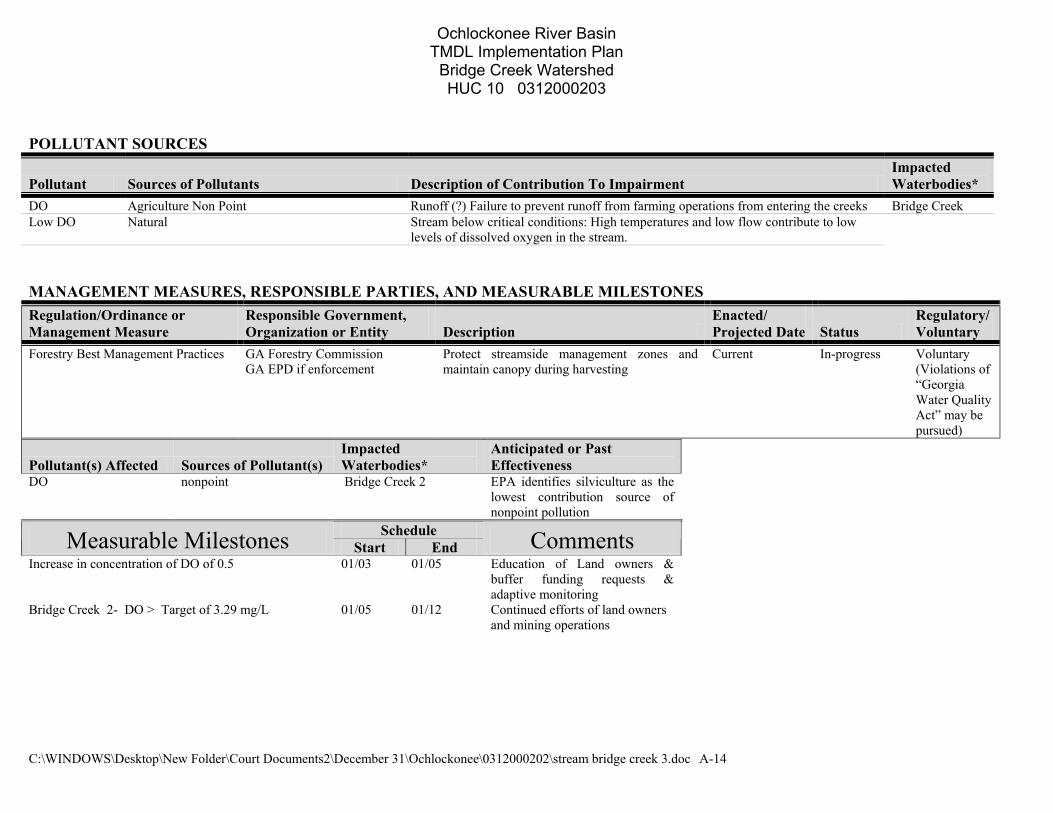
POLLUTANT SOURCES
Pollutant Sources of Pollutants Description of Contribution To Impairment Impacted Waterbodies*
DO Agriculture Non Point Runoff (?) Failure to prevent runoff from farming operations from entering the creeks Bridge Creek Low DO Natural Stream below critical conditions: High temperatures and low flow contribute to low
levels of dissolved oxygen in the stream. MANAGEMENT MEASURES, RESPONSIBLE PARTIES, AND MEASURABLE MILESTONES Regulation/Ordinance or Management Measure
Responsible Government, Organization or Entity Description
Enacted/ Projected Date Status
Regulatory/Voluntary
Forestry Best Management Practices GA Forestry Commission GA EPD if enforcement
Protect streamside management zones and maintain canopy during harvesting
Current In-progress
Voluntary (Violations of “Georgia Water Quality Act” may be pursued)
Pollutant(s) Affected Sources of Pollutant(s) Impacted Waterbodies*
Anticipated or Past Effectiveness
DO nonpoint Bridge Creek 2 EPA identifies silviculture as the lowest contribution source of nonpoint pollution
Schedule Measurable Milestones Start End Comments Increase in concentration of DO of 0.5 01/03 01/05 Education of Land owners &
buffer funding requests & adaptive monitoring
Bridge Creek 2- DO > Target of 3.29 mg/L 01/05 01/12 Continued efforts of land owners and mining operations
Ochlockonee River Basin TMDL Implementation Plan
Bridge Creek Watershed HUC 10 0312000203
C:\WINDOWS\Desktop\New Folder\Court Documents2\December 31\Ochlockonee\0312000202\stream bridge creek 3.doc A-15
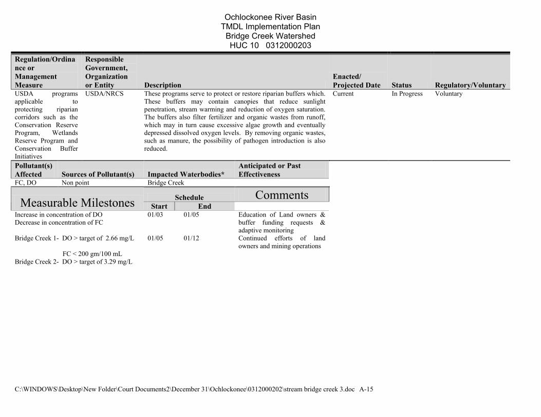
Regulation/Ordinance or Management Measure
Responsible Government, Organization or Entity Description
Enacted/ Projected Date Status Regulatory/Voluntary
USDA programsapplicable to protecting riparian corridors such as the Conservation Reserve Program, Wetlands Reserve Program and Conservation Buffer Initiatives
USDA/NRCS These programs serve to protect or restore riparian buffers which. These buffers may contain canopies that reduce sunlight penetration, stream warming and reduction of oxygen saturation. The buffers also filter fertilizer and organic wastes from runoff, which may in turn cause excessive algae growth and eventually depressed dissolved oxygen levels. By removing organic wastes, such as manure, the possibility of pathogen introduction is also reduced.
Current In Progress Voluntary
Pollutant(s) Affected Sources of Pollutant(s) Impacted Waterbodies*
Anticipated or Past Effectiveness
FC, DO Non point Bridge Creek
Schedule Comments Measurable Milestones Start End Increase in concentration of DO Decrease in concentration of FC
01/03 01/05 Education of Land owners & buffer funding requests & adaptive monitoring
Bridge Creek 1- DO > target of 2.66 mg/L 01/05 01/12 Continued efforts of land owners and mining operations
FC < 200 gm/100 mL Bridge Creek 2- DO > target of 3.29 mg/L
Ochlockonee River Basin TMDL Implementation Plan
Bridge Creek Watershed HUC 10 0312000203
C:\WINDOWS\Desktop\New Folder\Court Documents2\December 31\Ochlockonee\0312000202\stream bridge creek 3.doc A-16
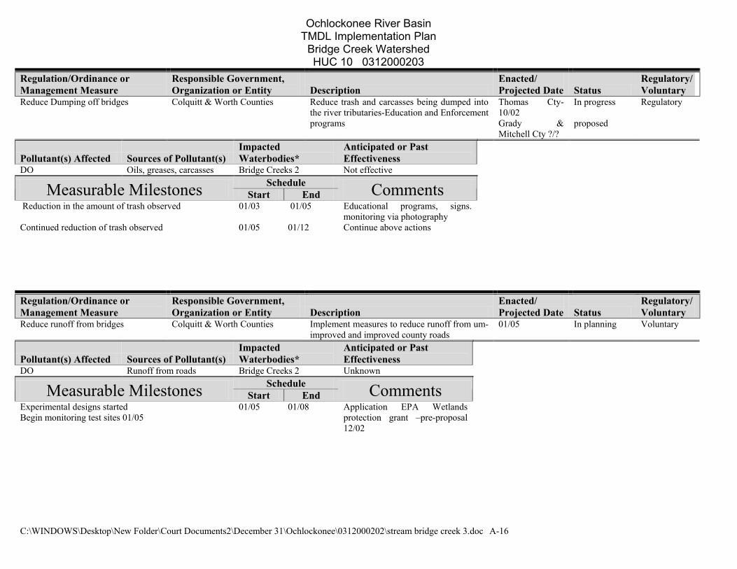
Regulation/Ordinance or Management Measure
Responsible Government, Organization or Entity Description
Enacted/ Projected Date Status
Regulatory/Voluntary
Reduce Dumping off bridges Colquitt & Worth Counties Reduce trash and carcasses being dumped into the river tributaries-Education and Enforcement programs
Thomas Cty- 10/02 Grady &Mitchell Cty ?/?
proposed
In progress
Regulatory
Pollutant(s) Affected Sources of Pollutant(s) Impacted Waterbodies*
Anticipated or Past Effectiveness
DO Oils, greases, carcasses Bridge Creeks 2 Not effective Schedule Measurable Milestones Start End Comments
Reduction in the amount of trash observed 01/03 01/05 Educational programs, signs. monitoring via photography
Continued reduction of trash observed
01/05 01/12 Continue above actions
Regulation/Ordinance or Management Measure
Responsible Government, Organization or Entity Description
Enacted/ Projected Date Status
Regulatory/Voluntary
Reduce runoff from bridges Colquitt & Worth Counties Implement measures to reduce runoff from um-improved and improved county roads
01/05 In planning Voluntary
Pollutant(s) Affected Sources of Pollutant(s) Impacted Waterbodies*
Anticipated or Past Effectiveness
DO Runoff from roads Bridge Creeks 2 Unknown Schedule Measurable Milestones Start End Comments
Experimental designs started Begin monitoring test sites 01/05
01/05 01/08 Application EPA Wetlands protection grant –pre-proposal 12/02
Ochlockonee River Basin TMDL Implementation Plan
Bridge Creek Watershed HUC 10 0312000203
C:\WINDOWS\Desktop\New Folder\Court Documents2\December 31\Ochlockonee\0312000202\stream bridge creek 3.doc A-17
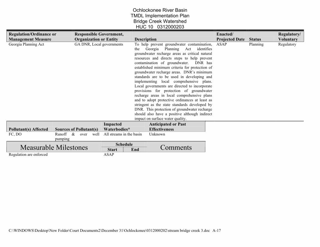
Regulation/Ordinance or Management Measure
Responsible Government, Organization or Entity Description
Enacted/ Projected Date Status
Regulatory/Voluntary
Georgia Planning Act GA DNR, Local governments To help prevent groundwater contamination, the Georgia Planning Act identifies groundwater recharge areas as critical natural resources and directs steps to help prevent contamination of groundwater. DNR has established minimum criteria for protection of groundwater recharge areas. DNR’s minimum standards are to be used in developing and implementing local comprehensive plans. Local governments are directed to incorporate provisions for protection of groundwater recharge areas in local comprehensive plans and to adopt protective ordinances at least as stringent as the state standards developed by DNR. This protection of groundwater recharge should also have a positive although indirect impact on surface water quality.
ASAP Planning Regulatory
Pollutant(s) Affected Sources of Pollutant(s) Impacted Waterbodies*
Anticipated or Past Effectiveness
FC, DO Runoff & over well pumping
All streams in the basin Unknown
Schedule Measurable Milestones Start End Comments Regulation are enforced ASAP
Ochlockonee River Basin TMDL Implementation Plan
Bridge Creek Watershed HUC 10 0312000203
C:\WINDOWS\Desktop\New Folder\Court Documents2\December 31\Ochlockonee\0312000202\stream bridge creek 3.doc A-18
Regulation/Ordinance or Management Measure
Responsible Government, Organization or Entity Description
Enacted/ Projected Date Status
Regulatory/Voluntary
Adaptive monitoring and watershed assesment
Thomas University Collecting samples upstream from established sites to isolate and identify sources of pollution. EPD will contract with USGS to sample sites initially sampled in 1998. They will employ revised protocols to sample sites to avoid the impacts of extreme low flow or ponding which may have influenced DO samples collected in 1998 and the subsequent assessments for listing on the 303(d).
01/03 In planning Voluntary
Pollutant(s) Affected Sources of Pollutant(s) Impacted Waterbodies*
Anticipated or Past Effectiveness
DO To be determined Entire basin Anticipated- very effective Schedule Measurable Milestones Start End Comments
Adaptive monitoring 1st cycle completed 01/03 01/04 Individuals, local govts, and EPD will be notified of the results
Increase in concentration of DO 01/04 01/12
Ochlockonee River Basin TMDL Implementation Plan
Bridge Creek Watershed HUC 10 0312000203
C:\WINDOWS\Desktop\New Folder\Court Documents2\December 31\Ochlockonee\0312000202\stream bridge creek 3.doc A-19
POTENTIAL FUNDING SOURCES
Funding Source Responsible Authority Status Anticipated Funding Amount
Impacted Waterbodies*
Georgia EPD Thomas University In Planning ?? Entire basin Archebold hospital Foundation Friends of the Ochlockonee River In Planning ?? Entire basin EPA Wetlands Protection Program Grant Thomas University Preliminary Proposal
Due on 02/12/02 To be determined Entire basin
EPA 319 Grant Thomas University & Local Govts In Planning To be Determined Entire Basin Williams Family Foundation Friends of the Ochlockonee River
In Planning To be Determined Entire Basin
Woodruff Foundation Thomas University To develop educational Materials
In Planning To Be Determined Entire Basin
MONITORING PLAN
Time Frame Name Of Regulation / Ordinance Or Management Measure Organization
Impacted Waterbodies* Pollutants Purpose/Description Start End
Status (Previous, Current, Proposed)
Initial monitoring USGS/EPD Entire Basin DO & FC To establish TMDLs 01/98 12/98 Previous Selective Monitoring Thomas University Entire Basin DO & FC To develop monitoring Protocols
And establish new monitoring sited
09/02 12/03 Current
EPD Monitoring Thomas University Established Sites DO & FC/EC
To monitor the effectiveness of the above plans
01/03 01/04 Proposed
Adaptive Monitoring Thomas University 303b streams DO,FC, Turbidity Nutrients, ets
Identify and locate sources of pollutants in each identified stream
01/03 ?? Proposed
Individual Industries Industries Various DO, FC, Turbidity Nutrients
Monitor the affected steam above and below the industry for water quality
01/03 ?? Voluntary program
COMMENTS: Before definitive actions can be taken, specific, offenders, land owners, and industries must be identified. The proposed adaptive monitoring procedures
will Aid in identifying the specific sources of pollutants in streams that have non point pollution sources. With this knowledge, local and state governments
will be able to enact or enforce existing statutes to correct the problem..
Ochlockonee River Basin TMDL Implementation Plan
Bridge Creek Watershed HUC 10 0312000203
C:\WINDOWS\Desktop\New Folder\Court Documents2\December 31\Ochlockonee\0312000202\stream bridge creek 3.doc A-20
Environmental Protection Division of the Department of Natural Resources, State of Georgia.
The preparation of this report was financed in part through a grant from the U.S. Environmental Protection Agency under the provisions of Section 106 of the Federal Water Pollution
Control Act, as amended.


![FINAL TMDL REPORT - Florida Dep · FINAL TMDL Report: Ochlockonee–St. Marks Basin; Munson Slough, WBID 807D (DO), Lake Munson, WBID 807C (DO, Nutrients [TSI], and Turbidity), and](https://img.pdfslide.net/doc/110x75/5b81affa7f8b9a7b6f8cf3d5/final-tmdl-report-florida-dep-final-tmdl-report-ochlockoneest-marks-basin.jpg)