Embed Size (px)
Citation preview

WEST BENGAL MINERAL DEVELOPMENT
& TRADING CORPORATION LIMITED
(WBMDTCL)
(A Govt. of West Bengal Undertaking) 13, Nellie Sengupta Sarani,
2nd Floor, Kolkata-700087 Tel No.: 033-22520643, Email: [email protected]
ENVIRONMENTAL IMPACT ASSESSMENT
AND
ENVIRONMENTAL MANAGEMENT PLAN
OF
GOURANGDIH ABC OPENCAST COAL MINING PROJECT
PROPOSED AT
VILLAGES PANURIA, KANTAPAHARI, JAMGRAM,
SHIBDHAWRA, BANDDHAWRA, LALBANDH, GOURANGDIH AND BHUIAPARA,
TEHSIL BARABANI CD BLOCK, DISTRICT PASCHIM BARDHAMAN, WEST BENGAL
{(2.5 MTPA R.O.M. COAL BY OPEN CAST)
(M.L. AREA: 213.27 HA, PROJECT AREA: 356.575 HA)}
FEBRUARY, 2019
Prepared by:
M IN M E C C ON S UL T A NC Y PV T . LT D . A- 1 2 1 , P a r y av a r a n C o mp l e x, IG N O U R o a d , N e w D e l h i – 1 10 0 3 0
Ph : 29 53 47 77, 29 53 22 36, 29 53 58 9 1 ; Fa x: 0 91- 1 1-2 95 32 56 8 Ema il :[email protected] m; Web site : ht tp: //www.minmec.co m
Estb. 1983 An ISO 9001:2015 approved company

WEST BENGAL MINERAL DEVELOPMENT
& TRADING CORPORATION LIMITED
(WBMDTCL)
(A Govt. of West Bengal Undertaking) 13, Nellie Sengupta Sarani,
2nd Floor, Kolkata-700087 Tel No.: 033-22520643, Email: [email protected]
ENVIRONMENTAL IMPACT ASSESSMENT
AND
ENVIRONMENTAL MANAGEMENT PLAN
OF
GOURANGDIH ABC OPENCAST COAL MINING PROJECT
PROPOSED AT
VILLAGES PANURIA, KANTAPAHARI, JAMGRAM,
SHIBDHAWRA, BANDDHAWRA, LALBANDH, GOURANGDIH AND BHUIAPARA,
TEHSIL BARABANI CD BLOCK, DISTRICT PASCHIM BARDHAMAN, WEST BENGAL
{(2.5 MTPA R.O.M. COAL BY OPEN CAST)
(M.L. AREA: 213.27 HA, PROJECT AREA: 356.575 HA)}
ISSUE 1 REV. 0 JULY, 2018 (Post TOR) ISSUE 1 REV. 1 FEBRUARY 2019 (Post PH)
Prepared by:
M IN M E C C ON S UL T A NC Y PV T . LT D . A- 1 2 1 , P a r y av a r a n C o mp l e x, IG N O U R o a d , N e w D e l h i – 1 10 0 3 0
Ph : 29 53 47 77, 29 53 22 36, 29 53 58 9 1 ; Fa x: 0 91- 1 1-2 95 32 56 8 Ema il :[email protected] m; Web site: ht tp:/ /www.minmec.com
An ISO 9001:2015 approved company
Estb. 1983
WBMDTC Ltd.
EIA/EMP for Proposed Gourangdih ABC Coal Mine i
CONTENTS
Sl. No. Description Page No.
CHAPTER 1 : INTRODUCTION
1.1 Purpose of the EIA report 1-1
1.2 Identification of the project 1-1
1.3 Project proponent 1-4
1.4 Brief description of the project 1-4
1.5 Scope of the study 1-8
1.6 Status of litigations 1-13
1.7 Compliance to TOR 1-13
1.8 Status of other clearances 1-25
CHAPTER 2 : PROJECT DESCRIPTION
2.1 General 2-1
2.2 Geology 2-2
2.3 Description of coal seams, coal quality and overburden 2-10
2.4 Details of exploration 2-13
2.5 Reserves 2-13
2.6 Mining 2-15
2.7 Production 2-23
2.8 Anticipated life of the mine and targeted capacity 2-24
2.9 Drilling and blasting pattern 2-24
2.10 Mode of transportation 2-24
2.11 Mineral beneficiation 2-24
2.12 Equipment and machinery 2-25
2.13 Site services/facilities 2-26
2.14 Water requirement 2-28
2.15 Employment potential 2-29
2.16 Power requirements 2-31
2.17 Proposed diversions 2-31
CHAPTER 3 : DESCRIPTION OF THE ENVIRONMENT
3.1 General 3-1
3.2 Topography and drainage 3-3
3.3 Climate and meteorology 3-4
3.4 Micro-meteorology survey 3-8
3.5 Ambient air quality 3-11
3.6 Noise environment 3-15

WBMDTC Ltd.
EIA/EMP for Proposed Gourangdih ABC Coal Mine ii
Sl. No. Description Page No.
3.7 Water resources 3-17
3.8 Soil quality 3-26
3.9 Ecology 3-27
3.10 Traffic density 3-32
3.11 Seismicity 3-33
3.12 Land environment 3-33
3.13 Socio- economic conditions 3-37
3.14 Industries around the mining lease in the study area 3-46
3.15 Places of tourist/religious/historical interest/national park/sanctuary
3-46
CHAPTER 4 : ANTICIPATED ENVIRONMENTAL IMPACT AND MITIGATION MEASURES
4.1 General 4-1
4.2 Topography and drainage 4-1
4.3 Climate 4-3
4.4 Air environment 4-4
4.5 Water environment 4-14
4.6 Land environment 4-26
4.7 Solid waste generation and management 4-33
4.8 Noise 4-42
4.9 Ground vibrations- impact and management 4-47
4.10 Impact due to traffic 4-48
4.11 Ecology 4-56
4.12 Socio-economic impacts and mitigation including resettlement and rehabilitation
4-60
4.13 Conservation of natural resources 4-61
4.14 Occupational health and safety 4-62
CHAPTER 5 : ANALYSIS OF ALTERNATIVES (TECHNOLOGY & SITE)
5.1 Site alternatives 5-1
5.2 Technology alternatives 5-1
CHAPTER 6 : ENVIRONMENTAL MONITORING PROGRAM
6.1 Introduction 6-1
6.2 Proposed set-up 6-1
6.3 Monitoring schedule and parameters 6-3
6.4 Budgetary provision for environmental management 6-4

WBMDTC Ltd.
EIA/EMP for Proposed Gourangdih ABC Coal Mine iii
Sl. No. Description Page No.
CHAPTER 7 : ADDITIONAL STUDIES: RISK ASSESSMENT, DISASTER MANAGEMENT PLAN AND PUBLIC CONSULTATION
7.1 Risk analysis and disaster management plan 7-1
7.2 Disaster management plan 7-9
7.3 Summary of the proceeding of public consultation 7-15
CHAPTER 8 : MINE CLOSURE PLAN
8.1 Introduction 8-1
8.2 Mine description 8-2
8.3 Mine closure plan 8-2
8.4 Economic repercussions of closure of mine and manpower retrenchments
8-6
8.5 Time scheduling for abandonment 8-7
8.6 Abandonment cost 8-8
8.7 Financial assurance 8-11
8.8 Responsibility of the mine owner 8-11
8.9 Provision for mine closure certificate 8-11
CHAPTER 9 : PROJECT BENEFITS
9.1 Employment potential 9-1
9.2 Physical & social infrastructure development due to mine 9-1
9.3 Corporate social responsibility of WBMDTC Ltd. 9-1
9.4 Corporate environment responsibility 9-2
CHAPTER 10 : ENVIRONMENTAL COST BENEFIT ANALYSIS 10-1
CHAPTER 11 : ENVIRONMENT MANAGEMENT PLAN
11.1 Environment management plan 11-1
11.2 Corporate environment policy 11-16
11.3 Standard operating process / procedures to address deviation/ violation
11-17

WBMDTC Ltd.
EIA/EMP for Proposed Gourangdih ABC Coal Mine iv
Sl. No. Description Page No.
CHAPTER 12 : EXECUTIVE SUMMARY OF EIA/EMP
12.1 Introduction 12-1
12.2 Project description 12-1
12.3 Present environmental scenario 12-3
12.4 Anticipated environmental impact and mitigation measures 12-7
12.5 Analysis of alternatives 12-12
12.6 Environmental control and monitoring organisation 12-13
12.7 Additional studies: disaster management plan 12-13
12.8 Project benefits 12-13
12.9 Consultants 12-14
CHAPTER 13 : DISCLOSURE OF CONSULTANTS ENGAGED 13-1
WBMDTC Ltd.
EIA/EMP for Proposed Gourangdih ABC Coal Mine v
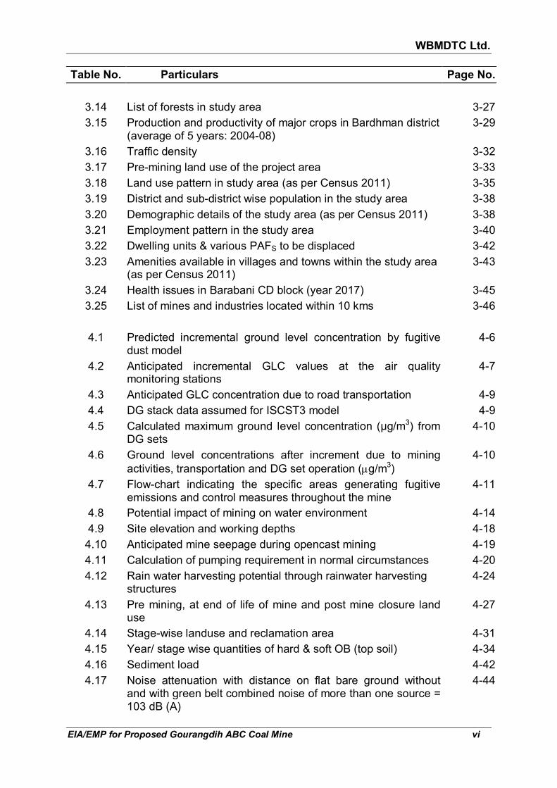
LIST OF TABLES
Table No. Particulars Page No.
1.1 Salient features of the project 1-2
1.2 Baseline data generated 1-10
1.3 Compliance of generic TOR for opencast mine project 1-13
1.4 Additional conditions in terms of reference letter issued by MOEF&CC
1-24
2.1 General stratigraphic sequence 2-2
2.2 Generalized stratigraphic sequence 2-3
2.3 Description of faults 2-5
2.4 Description and quality of coal seams 2-10
2.5 Qualitative description of coal seams (proximate and ultimate analysis)
2-11
2.6 Concentration (mg/kg) of trace elements in Indian coal & lignite and likely in proposed mine
2-12
2.7 Seam wise net geological reserves within ABC block 2-13
2.8 Net geological and available reserves in the block 2-14
2.9 Net geological reserves in batter, barrier, already extracted and net geological reserves under built-up area
2-14
2.10 Calendar programme of coal production, OB removal, and stripping ratio
2-23
2.11 List of proposed major HEMM 2-25
2.12 Water requirement 2-28
2.13 Estimated manpower requirement for 2.5 mtpa 2-30
3.1 Distance and direction of rivers/ nala 3-4
3.2 Temperature, relative humidity and rainfall, IMD station Bankura (MO)
3-4
3.3 Summary of micro-meteorological data 3-8
3.4 Wind frequency of monitored data 3-8
3.5 Location of air sampling stations 3-11
3.6 Procedure for determining various air quality parameters 3-14
3.7 Ambient air quality (Dec, 2017 to Feb 2018) 3-14
3.8 Heavy metals test result in air sample of core zone 3-15
3.9 Location of noise monitoring stations 3-16
3.10 Ambient noise levels in the study area (in leq dB(A)) 3-16
3.11 Water sampling locations 3-23
3.12 Summary of water quality in the study area 3-24
3.13 Soil test results 3-26
WBMDTC Ltd.
EIA/EMP for Proposed Gourangdih ABC Coal Mine vi
Table No. Particulars Page No.
3.14 List of forests in study area 3-27
3.15 Production and productivity of major crops in Bardhman district (average of 5 years: 2004-08)
3-29
3.16 Traffic density 3-32
3.17 Pre-mining land use of the project area 3-33
3.18 Land use pattern in study area (as per Census 2011) 3-35
3.19 District and sub-district wise population in the study area 3-38
3.20 Demographic details of the study area (as per Census 2011) 3-38
3.21 Employment pattern in the study area 3-40
3.22 Dwelling units & various PAFS to be displaced 3-42
3.23 Amenities available in villages and towns within the study area (as per Census 2011)
3-43
3.24 Health issues in Barabani CD block (year 2017) 3-45
3.25 List of mines and industries located within 10 kms 3-46
4.1 Predicted incremental ground level concentration by fugitive dust model
4-6
4.2 Anticipated incremental GLC values at the air quality monitoring stations
4-7
4.3 Anticipated GLC concentration due to road transportation 4-9
4.4 DG stack data assumed for ISCST3 model 4-9
4.5 Calculated maximum ground level concentration (µg/m3) from DG sets
4-10
4.6 Ground level concentrations after increment due to mining
activities, transportation and DG set operation (µg/m3)
4-10
4.7 Flow-chart indicating the specific areas generating fugitive emissions and control measures throughout the mine
4-11
4.8 Potential impact of mining on water environment 4-14
4.9 Site elevation and working depths 4-18
4.10 Anticipated mine seepage during opencast mining 4-19
4.11 Calculation of pumping requirement in normal circumstances 4-20
4.12 Rain water harvesting potential through rainwater harvesting structures
4-24
4.13 Pre mining, at end of life of mine and post mine closure land use
4-27
4.14 Stage-wise landuse and reclamation area 4-31
4.15 Year/ stage wise quantities of hard & soft OB (top soil) 4-34
4.16 Sediment load 4-42
4.17 Noise attenuation with distance on flat bare ground without and with green belt combined noise of more than one source = 103 dB (A)
4-44

WBMDTC Ltd.
EIA/EMP for Proposed Gourangdih ABC Coal Mine vii
Table No. Particulars Page No.
4.18 Permissible peak particle velocity (PPV) at the foundation level of structures in mining areas in mm/sec
4-47
4.19 Observed existing, additional traffic and their % utilisation 4-50
4.20 Villages along the coal transportation routes 4-50
4.21 Distance between two trucks for different routes 4-52
4.22 Stage-wise cumulative plantation 4-59
6.1 Monitoring schedule and parameters 6-3
6.2 Capital investment for environmental protection 6-5
6.3 Recurring annual cost for environmental protection 6-6
7.1 Check list for likely disasters in opencast mines 7-2
7.2 Proposed teams to deal with emergency situation 7-9
7.3 Statement of main issues raised by the public and response of the project proponent with action plan
7-16
8.1 Post closure land use 8-2
8.2 Expenditure for mine closure activities 8-9
8.3 Year-wise cost of mine closure 8-10
9.1 Present physical & social infrastructure need assessment and proposed interventions
9-4
9.2 Estimated capital cost & recurring expenditure under CER for Gourangdih ABC coal mine project
9-9
11.1 Environment management measures 11-1

WBMDTC Ltd.
EIA/EMP for Proposed Gourangdih ABC Coal Mine viii
LIST OF FIGURES
Figure No. Particulars Page No.
1.1 Map showing boundary of Gourangdih ABC coal block, sub-blocks A, B & C and project boundary
1-5
1.2 Location map of the project 1-6
2.1 Geological plan 2-7
2.2 Geological cross-sections of Quarry-A 2-8
2.3 Geological cross-section of Quarry-C 2-9
2.4 Line diagram representing the sequence of mining 2-17
2.5 Present surface plan 2-18
2.6 Mine stage plan at the end of 5th year 2-19
2.7 Mine stage plan at the end of 10th year 2-20
2.8 Mine stage plan at the end of 15th year 2-21
2.9 Mine stage plan at the end of 27th year (final stage) 2-22
2.10 Water balance diagram 2-29
3.1 Topography and drainage map of study area 3-2
3.2 Month wise average mini. & max. temperature (°C) at Bankura MO (1990-2007)
3-5
3.3 Monthly average relative humidity at 0830 hrs & 1730 hrs at Bankura MO (1990-2007)
3-6
3.4 Monthly average rainfall (mm) at Bankura MO (1990-2007) 3-6
3.5 Windrose diagram at IMD station Bankura (MO) at 8:30 hrs 3-7
3.6 Windrose diagram at IMD station Bankura (MO) at 17.30 hrs 3-7
3.7 Windrose diagram of monitored data 3-10
3.8 Location of sampling stations 3-13
3.9 Water table elevation contour map (January 2018) 3-20
3.10 Forest map of the study area based on open series map 3-30
3.11 Land ownership map 3-34
3.12 Land use pattern in the study area (Census 2011) 3-35
3.13 Satellite imagery of 10 km radius 3-36
3.14 Literacy level in the study area (Census 2011) 3-39
3.15 Break up of SC & ST in the study area (Census 2011) 3-39
3.16 Employment pattern in the study area (Census 2011) 3-41
3.17 Break up of marginal workers in the study area (Census 2011) 3-41
3.18 Break up of main workers in the study area (Census 2011) 3-41
3.19 Break up of total workers (main & marginal) in the study area (Census 2011)
3-41
3.20 Location of industries 3-47

WBMDTC Ltd.
EIA/EMP for Proposed Gourangdih ABC Coal Mine ix
Figure No. Particulars Page No.
4.1 Gravimetric oil water separator 4-23
4.2 Recharge structure for roof run off 4-25
4.3 Rain water oil trap and desilting chamber prior to surface reservoir
4-26
4.4 Conceptual plan 4-28
4.5 Cross sections of Quarry-A 4-29
4.6 Cross sections of Quarry-C 4-30
4.7 Final stage dump plan 4-38
4.8 Mine closure plan 4-39
4.9 Sections of final dumps 4-40
4.10 Noise attenuation with distance in all directions over flat open bare ground (sound at source = 103 dBA)
4-43
4.11 The map showing 45 m wide afforestation on both side of Gourangdih-B block
4-46
4.12 The proposed railway siding and connecting roads to be used for transportation of coal
4-49
4.13 Noise level contour for different routes 4-52
4.14 15th year stage plan showing existing roads (no. 1&2) passing through ML area and the proposed diversion of these roads as well as the road (no. 3) to be strengthened
4-55
6.1 Organisation chart for implementation of pollution control measures
6-2
7.1 Organisation for dealing with emergency situation 7-9
8.1 Final mine closure plan 8-4
12.1 Map showing sub-blocks and sequence of mining 12-3

WBMDTC Ltd.
EIA/EMP for Proposed Gourangdih ABC Coal Mine x
LIST OF ANNEXURES
Annexure No. Particulars Page No.
I Terms of Reference for preparation of EIA/EMP Report vide J-11015/80/2017-IA.II (M) dated 29th September, 2017
A-1
II Allotment letter of Gourangdih ABC Coal Mine to WBMDTC Ltd. by Ministry of Coal, vide F. No. 103/6/2016/NA dated September 29, 2016
A-11
III Approval letter of Mining Plan including Mine Closure Plan of Gourangdih ABC Coal vide letter no. 13016/77/2006-CA-I (Part) dt. 28-06-2011
A-21
IV Test result of heavy metal content in coal sample procured from adjacent Gourangdih D coal block
A-22
V Daily micro-meteorological monitored data A-23
VI Ambient air quality test results A-25
VII National ambient air quality standard (NAAQS) A-29
VIII Noise level monitoring data A-31
IX Ambient air quality standards in respect of noise A-33
X Damage risk criteria for hearing loss, occupational safety and health administration (OSHA)
A-34
XI Monitored water level data in study area A-35
XII Water quality test results A-39
XIII Indian Standards/ Specifications for drinking water (IS 10500 : 2012)
A-49
XIV List of flora in the study area and core zone A-52
XV List of fauna in the study area and core zone A-55
XVI Traffic density monitoring results A-58
XVII Land use pattern in the study area based on Census 2011 A-61
XVIII Village wise population and literacy within the study area (Census 2011)
A-66
XIX Village wise employment pattern in the study area (Census 2011)
A-72
XX Village wise amenities in the study area (Census 2011) A-78
XXI Air quality prediction model using Fugitive Dust Model (FDM) for determination of incremental ground level concentrations due to emissions from project area
A-95

WBMDTC Ltd.
EIA/EMP for Proposed Gourangdih ABC Coal Mine xi
Annexure No. Particulars Page No.
XXII Air quality prediction model using CAL3QHCR model for determination of incremental ground level concentrations due to emissions from road transportation in the study area
A-107
XXIII Air quality prediction model using ISCST3 model for determination of incremental ground level concentrations due to emissions from DG sets in project area
A-127
XXIV NABL certificate for laboratory A-151
XXV Delhi High Court order permission to consultant for preparation of EIA/EMP report
A-152
XXVI Corporate Environmental Policy of WBMDTC Ltd. Along with MOM
A-157
XXVII Public Hearing Documents A-162
XXVIII Application for Road diversion A-181
XXIX Application to SWID for abstraction of Ground water A-182
WBMDTC Ltd.
EIA/EMP for Proposed Gourangdih ABC Coal Mine xii
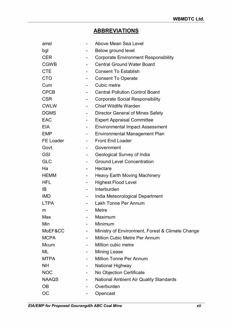
ABBREVIATIONS
amsl - Above Mean Sea Level
bgl - Below ground level
CER - Corporate Environment Responsibility
CGWB - Central Ground Water Board
CTE - Consent To Establish
CTO - Consent To Operate
Cum - Cubic metre
CPCB - Central Pollution Control Board
CSR - Corporate Social Responsibility
CWLW - Chief Wildlife Warden
DGMS - Director General of Mines Safety
EAC - Expert Appraisal Committee
EIA - Environmental Impact Assessment
EMP - Environmental Management Plan
FE Loader - Front End Loader
Govt. - Government
GSI - Geological Survey of India
GLC - Ground Level Concentration
Ha - Hectare
HEMM - Heavy Earth Moving Machinery
HFL - Highest Flood Level
IB - Interburden
IMD - India Meteorological Department
LTPA - Lakh Tonne Per Annum
m - Metre
Max - Maximum
Min - Minimum
MoEF&CC - Ministry of Environment, Forest & Climate Change
MCPA - Million Cubic Metre Per Annum
Mcum - Million cubic metre
ML - Mining Lease
MTPA - Million Tonne Per Annum
NH - National Highway
NOC - No Objection Certificate
NAAQS - National Ambient Air Quality Standards
OB - Overburden
OC - Opencast

WBMDTC Ltd.
EIA/EMP for Proposed Gourangdih ABC Coal Mine xiii
PM10 - Particulate Matter less than 10 microns
PM 2.5 - Particulate Matter less than 2.5 microns
RH - Relative Humidity
ROM - Run of Mine
RPM - Respirable Particulate Matter
R&R - Rehabilitation & Resettlement
SC - Scheduled Cast
SPCB - State Pollution Control Board
SPM - Suspended Particulate Matter
ST - Scheduled Tribe
T - Tonne
Te - Tonne
TPD - Tonne Per Day
TOR - Terms of Reference
UG - Underground
WBMDTCL - West Bengal Mineral Development & Trading Corporation Limited
wrt - with respect to

WBMDTC Ltd.
EIA/EMP for Proposed Gourangdih ABC Coal Mine 1-1
CHAPTER 1
INTRODUCTION 1.1 PURPOSE OF THE EIA REPORT
Environmental Clearances is a statutory requirement for the projects listed in the Schedule of EIA notification dated 14th September 2006 and its amendments till date. Coal blocks more than 150 ha mining lease area fall under Sl. No. 1(a) in category A of the schedule to the EIA Notification 2006. Category A project shall seek Environmental clearance from the Ministry of Environment, Forest & Climate Change (MoEF&CC), New Delhi. The procedure covers submission of application with Form 1 and pre-feasibility report to MoEF&CC, preparation of draft EIA/EMP in line with the Terms of Reference, applying to the State Pollution Control Board for public hearing, recording of suggestions/ objections and statements of the public and finalizing the EIA/EMP report after incorporating the responses and action plans to the points raised by the public. The final EIA/EMP report shall be submitted to the MoEF&CC which shall be appraised by the Expert Committee and thereafter only the Environmental Clearance can be granted.
To obtain the Environmental Clearance for the proposed project, environmental studies have been carried out and Environmental Impact Assessment (EIA) / Environment Management Plan (EMP) has been prepared in line with Terms of References (TOR) issued by Ministry of Environment, Forest & Climate Change, New Delhi. This EIA/EMP report has been prepared for proposed 2.5 million tonnes per annum (MTPA) coal production by mechanized open cast method in the total project area of 356.575 ha by M/s West Bengal Mineral Development and Trading Corporation Limited (WBMDTC Ltd.) in villages Panuriya (also spelt as Panuria), Kantapahari, Jamgram, Shibdhawra (also spelt as Shibdhara), Banddhawra, Lalbandh, Gourangdih and Bhuiapara, Barabani CD Block, District Paschim Bardhaman, West Bengal. The mining lease area is proposed as 213.27 ha.
The proposal i.e. Form I and Pre Feasibility Report for proposed open cast coal mine project was submitted to Ministry of Environment, Forests and Climate Change, New Delhi vide Letter no. MDTC/PM-5/144(Env)/721 dated 25.08.2017. TOR presentation was made to EAC-MoEF on 26.09.2017. Thereafter, the Expert Appraisal Committee recommended Terms of Reference for preparation of EIA/EMP Report vide J-11015/80/2017-IA.II (M) dated 29th September, 2017 (copy given in Annexure I).
1.2 IDENTIFICATION OF THE PROJECT
M/s West Bengal Mineral Development and Trading Corporation Limited (WBMDTC Ltd.) has been allotted Gourangdih ABC Coal Mine by Ministry

WBMDTC Ltd.
EIA/EMP for Proposed Gourangdih ABC Coal Mine 1-2
of Coal, vide F. No. 103/6/2016/NA dated September 29, 2016 (copy given in Annexure II).
History of Gourangdih A, B & C Blocks (Source : Para 1.2 of Mining Plan).
Previous to the allotment, parts of the coal mine had been exploited by both
underground and opencast mining method since long. Due to insufficient geological information, mining activities in different time period were scattered. During pre-nationalization period private companies like M/s Bird & Co., Burrakar Coal Company and others worked extensively the B-V seam by underground mining. B-VI seam was also developed in certain areas. B-II, B-IV and B-VI seams have also been exploited by open cast workings at some places.
Apart from the exploitation of coal, some private lessees worked fire clay
quarries along the outcrop of B-V seams in the western part of the area. The extent of these quarries is limited in the west and east by faults F2-F2 and F6-F6 respectively. They are now abandoned.
Mine was earlier allotted to Gourangdih Coal Ltd. (A Joint Venture of HEPL and JSW Steel Ltd.) and TOR had been issued to them vide MOEF’s letter no. J-11015/12/2011-IA.II(M) dated 30.06.2011 (Source: online proposal no. IA/WB/CMIN/7273/2010 on environmentclearance.nic.in). However, the coal block allocation was cancelled based on Supreme Court orders in the year 2014. Thereafter this coal mines was allocated to WBMDTC Ltd. Due to lapse of validity of TOR awarded to previous allotee, WBMDTC Ltd, the new allottee submitted a fresh proposal with same parameters i.e. based on the already approved mining plan. The mining plan and mine closure plan was approved by Ministry of Coal on 28.06.2011 and the same has been transferred to and will be followed by new allottee i.e. WBMDTC Ltd.
Salient features
The salient features of the project are summarized in Table 1.1.
TABLE 1.1 SALIENT FEATURES OF THE PROJECT
Project name Gourandih ABC Opencast Coal Mining Project
Project proponent West Bengal Mineral Development and Trading Corporation Ltd. (WBMDTC Ltd.)
Villages in block area Panuriya (Panuria), Kantapahari, Jamgram, Shibdhawra (Shibdhara), Banddhawra, Lalbandh, Gourangdih and Bhuiapara
Coordinates 23° 48' 30" to 23° 49' 45" N
85° 57' 45" to 85° 00' 15" E
(as per allotment letter dt. 29.12.2016)

WBMDTC Ltd.
EIA/EMP for Proposed Gourangdih ABC Coal Mine 1-3
Allotted block area 370 Ha
Required Mining Lease
Area
213.27 Ha
Area required Outside
lease
143.305 Ha
Project Area 356.575 Ha
Sub-blocks in main block of 370 Ha
Gourangdih A - 127.53 Ha
Gourangdih B - 90.83 Ha
Gourangdih C - 151.64 Ha
Intent to mine Only Gourangdih A & C (as per approved mining plan)
Pre Mining landuse
break up
Land pattern Area (ha)
Agricultural Land 48.43
Fallow land (Danga) 44.07
Degraded land (Old quarry area) 61.316
Built up area 60.86
Water body 15.44
Forest land (protected & jungle) 109.459
Non agricultural land for colony (outside core area)
5.00
Non agricultural land for Rehabilitation (outside core area)
12.00
Total 356.575
Total Geological Reserve � Net geological reserve, Quarry A, B & C = 129.15 Million Tonnes (MT)
� Quarry A&C ( which are proposed to be mined) = 68.37 MT ( Gourangdih A-27.18 MT + Gourangdih C-41.2 MT and Gourangdih B-Nil as the area is heavily build-up)
Mineable Reserves 68.37 million tonnes (from Gourangdih A&C, which are proposed to be mined)
Extractable Reserves 24.46 (Gourangdih A) + 37.08 (Gourangdih C) = 61.54 million tonnes
Rated capacity 2.5 MTPA
Life of the mine 27 years
Stripping ratio 2.91 cum/t
Total OB Generation 179.37 Mcum
Method of Mining Opencast Mechanized
Blasting Blasting required for Overburden and coal extraction.
Storage of explosives Shed/ Magazine
Working days 330 days, 3 shifts

WBMDTC Ltd.
EIA/EMP for Proposed Gourangdih ABC Coal Mine 1-4
Manpower 494 for mining, 268 for ancillary jobs
Transportation By road or rail to consumers
Expected cost of the
project
Rs. 621.71 crores (as per estimates in Revised Mining Plan of 2011)
Elevation 135 m to 174 m a.m.s.l.
Topography Mostly plain with gentle undulations and general northerly slope
Water requirement 530 KLD for potable and 454 KLD for industrial purpose.
Source of water Ajay River till mine sump water becomes available to meet the demand
Power requirement 11 KVA
Power source Power will be received from WBSEB through 33 KVA overhead line. It is stepped down to 11 KVA
1.3 PROJECT PROPONENT West Bengal Mineral Development and Trading Corporation Limited
(WBMDTC Ltd.), a government of West Bengal undertaking was incorporated in the year 1973 and has been engaged in the field of mining and trading of minerals in West Bengal since it’s inception.
WBMDTC Ltd. has adopted and implemented new business strategies in its
different sectors which have started yielding positive results. With the enactment of Coal Mines (Special Provisions) Act, 2015, WBMDTC Ltd had became eligible to get allocation of coal mines for sale of coal. WBMDTC Ltd. was declared by the Ministry of Coal as the allottee of Gourangdih ABC Coal Mine located in Paschim Bardhaman district.
1.4 BRIEF DESCRIPTION OF THE PROJECT 1.4.1 Nature of project The proposed project will be an open cast mechanized mine having
production capacity 2.5 MTPA, mining lease area of 213.27 Ha and project area 356.575 ha. Project has been classified as “Category-A” Mining Project as per the EIA Notification dated 14th September, 2006.
1.4.2 Size The total block area is 370 Ha. Gourangdih block is divided into three sub
blocks namely Gourangdih A (area: 127.53 Ha.), Gourangdih B (area: 90.83 Ha.) and Gourangdih C (area: 151.64 Ha.). The block boundary of Gourangdih ABC mine as well as its sub-blocks can be seen in Fig 1.1 below. Among the 3 sub blocks, Gourangdih A and Gourangdih C have been worked partially both by Underground and opencast method.

WBMDTC Ltd.
EIA/EMP for Proposed Gourangdih ABC Coal Mine 1-5
Gourangdih B being the most thickly populated and built up area, the underlying seams were not worked and are mostly virgin. The proposal for mining as per Approved Revised Mining Plan is to mine Gourangdih-A and C, leaving Gourangih-B undisturbed due to dense settlement. Proposed production from the mine will be 2.5 MTPA. Anticipated life of mine would be 27 years. Opencast mining method has been selected.
FIG 1.1:
MAP SHOWING BOUNDARY OF GOURANGDIH ABC COAL BLOCK, SUB-BLOCKS A, B & C AND PROJECT BOUNDARY
1.4.3 Location
The mine is present in villages Panuriya (or Panuria), Kantapahari, Jamgram, Shibdhawra (or Shibdhara), Banddhawra, Lalbandh, Gourangdih and Bhuiapara in Barabani CD Block of District Paschim Bardhaman, West Bengal. The Block area falls in the Survey of India, Open Series Map no. F45C13 and F45D1. The area is bound by following co-ordinates:
Latitude : 23°48'30" to 23°49'45" N Longitude : 86°57'45" to 87°00'15" E The location can be seen in Fig 1.2. 1.4.4 Communication
Road Link The area is well connected by the road. Two roads pass through the project
area. One is Asansol-Gourangdih road connecting Runakuraghat via Jamgram, which passes over the eastern flank of Gourangdih C quarry. Second is Rupnarayanpur-Gourangdih road, which passes through Gourangdih-A sub-block in western portion. At a later stage, these roads are proposed to be diverted as they will pass through quarry area, details of which are discussed in section 4.2.1 of Chapter 4 of this report. The distance and direction to various significant roads around the mine is given below:

WBMDTC Ltd.
EIA/EMP for Proposed Gourangdih ABC Coal Mine 1-6
FIG 1.2: LOCATION MAP OF THE PROJECT

WBMDTC Ltd.
EIA/EMP for Proposed Gourangdih ABC Coal Mine 1-7
Roads Distance &Direction from Project
Jamgram-Baraboni Road Within
NH-2, Kulti to Durgapur 13.4 km, SSW
Domahani-Jamuria Road 7.2 km, SSE
NH-419, Kulti to Gobindpur 7.8 km, W
Railway Link Gourangdih was a terminal railway station of Andal Gourangdih section of
the Eastern railway and is located about 38 km from Andal, on the Howrah-Delhi line of Eastern Railway. The railway line connecting Gourangdih Station and Andal has since then been abandoned.
The present nearest railway lines and stations are listed below:
Distance, km
(from project)
Direction
(from project)
Railway lines
� Sitarampur to Tapasi 7.1 S
� Jamtara to Asansol 7.7 W
� Dhanbad to Asansol 12.4 SSW
Railway Stations
� Rupnarayanpur R.S. 7.8 W
� Sitarampur R.S. 12.5 SW
� Asansol R.S. 13.0 S
Airport
Kolkata airport is situated at a distance of about 195 km SE and Andal
airport at a distance of 40 km SE. 1.4.5 Importance to Country & Region
(source: http://coal.nic.in/content/coal-indian-energy-choice and https://www.pwc.in/ assets/pdfs/industries/power-mining/icc-coal-report.pdf accessed 12.08.2017)
Coal is the most important and abundant fossil fuel in India. It accounts for
55% of the country's energy need. The country's industrial heritage was built upon indigenous coal.
Commercial primary energy consumption in India has grown by about 700%
in the last four decades. The current per capita commercial primary energy consumption in India is about 350 kgoe/year which is well below that of developed countries. Driven by the rising population, expanding economy

WBMDTC Ltd.
EIA/EMP for Proposed Gourangdih ABC Coal Mine 1-8
and a quest for improved quality of life, energy usage in India is expected to rise. Considering the limited reserve potentiality of petroleum & natural gas, eco-conservation restriction on hydel project and geo-political perception of nuclear power, coal will continue to occupy centre-stage of India's energy scenario.
India is the third largest coal producing country in the world. Hence, coal is
an important constituent of the present Indian economy. The total reserves of coal in India have been over 290 billion metric tons. The coalfields in India are located mostly in Jharkhand, Odisha, Madhya Pradesh, Chhattisgarh, Uttar Pradesh, Meghalaya, Telangana, West Bengal, Sikkim, Arunachal Pradesh and Bihar. India has the fifth largest coal reserves in the world. Of the total reserves, nearly 88% are non-coking coal reserves, while tertiary coals reserves account for a meagre 0.5 % and the balance is coking coal. The Indian coal is characterised by its high ash content (45%) and low sulphur content. The lignite reserves stand at a level around 36 billion tonnes, of which 90 % occur in the southern State of Tamil Nadu.
The power sector is the largest consumer of coal followed by the iron and
steel and cement segments. India is the world’s fifth largest energy consumer, accounting for 4.1% of the global energy consumption. Of the total electricity consumed in the country, approximately 80% is produced from coal.
Raniganj Coalfield, is the birth place of coal mining in the country. Area of
Raniganj Coalfield is 1530 Sq.Kms spreading over Burdwan, Birbhum, Bankura and Purulia Districts in West Bengal and Dhanbad District in Jharkhand. Heart of Raniganj Coalfield is, however, in Burdwan District bounded by Ajay River in North and Damodar River in South. Raniganj Coalfield of E.C.L. has special characteristic containing the best type of non-coking coal reserves in the country. All the heat intensive industries like Glass, Ceramic, Retractories, Forging etc. are exclusively dependent on Raniganj Coal. Other industries also prefer Raniganj Coal. The entire Export of Coal from the country is being done from Raniganj Coalfield. (Source: http://bardhaman.nic.in/mines/mines.htm, accessed on 28.02.2018)
This project, being a commercial coal block will be able to fulfil the demand
of the local industries in the region at low transportation costs, therefore providing them with the impetus necessary for growth.
1.5 SCOPE OF THE STUDY The Environmental Impact Assessment and Environment Management Plan
for the mine addressing the environment related issues are prepared in accordance with the requirements of Terms of Reference prescribed by Ministry of Environment, Forest & Climate Change, Govt. of India.
The study evaluates the prevailing environmental conditions. The adverse
impacts have been identified and possible mitigation measures have been drawn in order to protect the environment. In order to carry out the study,

WBMDTC Ltd.
EIA/EMP for Proposed Gourangdih ABC Coal Mine 1-9
the baseline environmental scenario has been established and the project activities superimposed on them to assess the impact and subsequent mitigation.
The main objectives of the present EIA study are briefly summarized below:
- To establish the baseline environmental scenario.
- To identify, predict and assess the future impacts of proposed project on the environment.
- To prepare a detailed action plan for implementation of mitigation measures.
- To suggest preventive measures to minimize adverse impacts and to maximize beneficial impacts.
- To suggest a monitoring programme to evaluate the effectiveness of mitigation measures.
- To suggest the formation of a core group responsible for implementation of the EMP.
- To prepare a capital cost estimate for environment management plan.
- To address the concerns of disaster management, R&R plan, CER and points raised in public hearing.
The scope of the present study is to conduct EIA covering all the disciplines
of environment and field monitoring in relevant disciplines over one full season of 3 (three) months (excluding monsoon months). The draft EIA report is prepared as per the MoEF&CC Notification dated 14.09.2006 and it’s amendments till date. After completion of the Public Consultation, all the environmental concerns expressed during the Public Consultation process will be addressed and appropriate changes in the draft EIA Report will be made accordingly to formulate the Final EIA Report. The final EIA Report will then be presented to the Expert Appraisal Committee (EAC) of MoEF&CC. Any queries raised by EAC, will be clarified and replies will be submitted to them.
Study area: The project area (356.57 ha) is termed as "core zone". The area within 10
km radius around the periphery of the project boundary has been considered as the “buffer zone” for identifying and assessing impact with respect to air, water, noise, land use, ecology, socio-economic environment, etc. The core zone and buffer zone together comprise the "study area".
Data Generation: The data that have been generated during winter season from 1st of
December, 2017 to 28th of February, 2018 by NABL accredited Min Mec
WBMDTC Ltd.
EIA/EMP for Proposed Gourangdih ABC Coal Mine 1-10
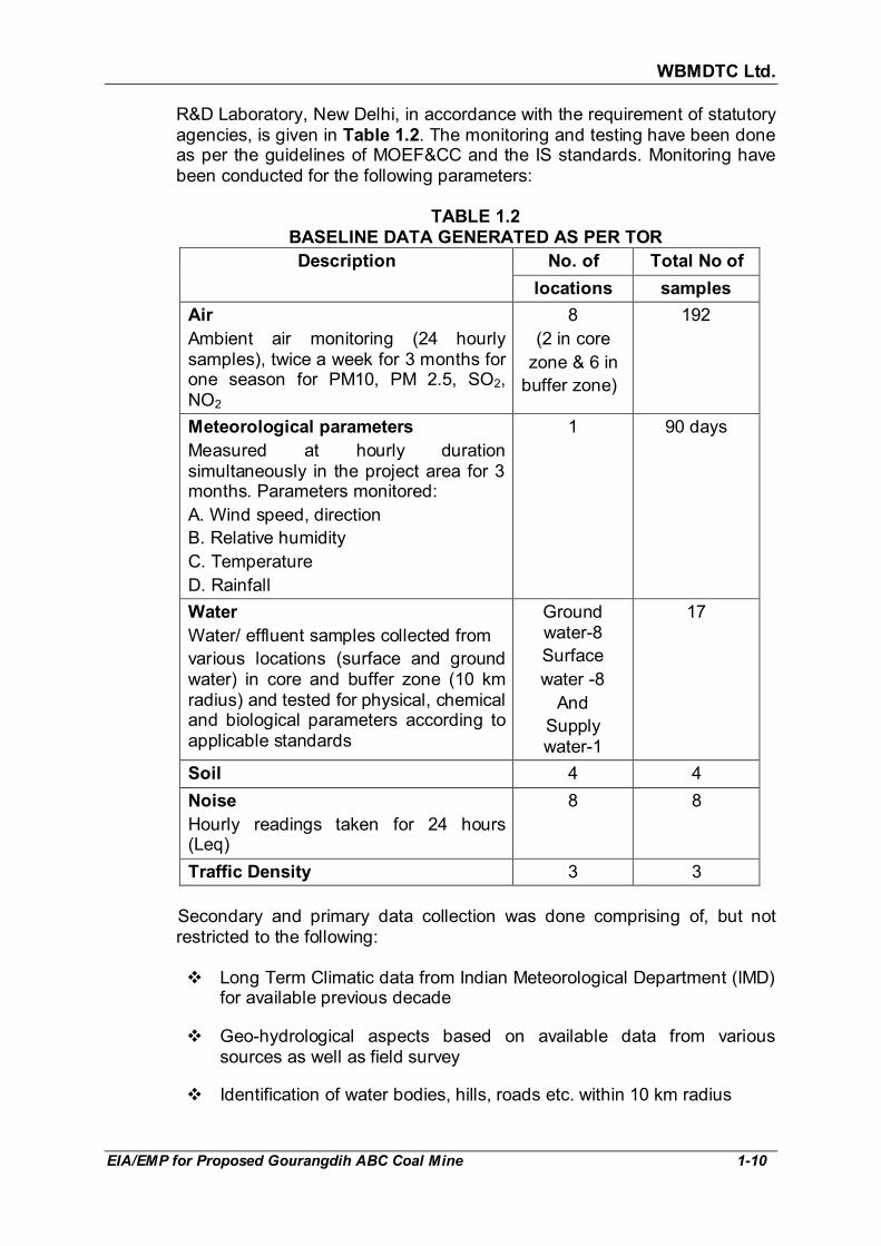
R&D Laboratory, New Delhi, in accordance with the requirement of statutory agencies, is given in Table 1.2. The monitoring and testing have been done as per the guidelines of MOEF&CC and the IS standards. Monitoring have been conducted for the following parameters:
TABLE 1.2
BASELINE DATA GENERATED AS PER TOR
Description No. of Total No of
locations samples
Air
Ambient air monitoring (24 hourly samples), twice a week for 3 months for one season for PM10, PM 2.5, SO2, NO2
8
(2 in core
zone & 6 in
buffer zone)
192
Meteorological parameters
Measured at hourly duration simultaneously in the project area for 3 months. Parameters monitored:
A. Wind speed, direction
B. Relative humidity
C. Temperature
D. Rainfall
1 90 days
Water
Water/ effluent samples collected from
various locations (surface and ground water) in core and buffer zone (10 km radius) and tested for physical, chemical and biological parameters according to applicable standards
Ground water-8
Surface
water -8
And
Supply water-1
17
Soil 4 4
Noise
Hourly readings taken for 24 hours (Leq)
8 8
Traffic Density 3 3
Secondary and primary data collection was done comprising of, but not restricted to the following:
� Long Term Climatic data from Indian Meteorological Department (IMD)
for available previous decade
� Geo-hydrological aspects based on available data from various sources as well as field survey
� Identification of water bodies, hills, roads etc. within 10 km radius

WBMDTC Ltd.
EIA/EMP for Proposed Gourangdih ABC Coal Mine 1-11
� Details of fauna, flora, information in forests, major habitats, sanctuaries, sensitive places within a distance of 10 km from the project site (including forest details).
� Major industries within 10 km radius.
� Historical monuments and sanctuaries within 10 km radius.
� Land use pattern within core zone and buffer zone (10 km radius around the core zone), Cropping pattern.
� Demography and Socio-economic based on last available Census data for entire study area, etc.
The preparation of the EIA/EMP report has been done as per the generic
structure prescribed in EIA Notification dated 14th September 2006, as follows:
� Chapter 1: Introduction covering Purpose of the report, Identification of
project & project proponent, Brief description of nature, size, location of the project and its importance to the country, region and Scope of the study – details of regulatory scoping carried out (As per Terms of Reference)
� Chapter 2: Project Description. (Based on study of the Approved
Revised Mining Plan, April 2011)
This includes condensed description of those aspects of the project (based on project feasibility study, Mining Plan & Mining Scheme), likely to cause environmental effects. Details such as type of project, project boundary & project site layout, size or magnitude of operation (including associated activities required by or for the project), proposed schedule for approval and implementation, technology and process description.
� Chapter 3: Present Baseline Scenario. The base line data generated
and collected has been used to establish the present environmental scenario. This covers the Study area, period, components & methodology, establishment of baseline for valued environmental components, as identified in the scope and base maps of applicable environmental components
� Chapter 4: Environmental Impacts & Mitigation. (Identification,
prediction and evaluation of Anticipated Environmental Impacts due to the proposed mine)
The impact assessment and mitigation planning, where applicable, has
been done for:
- Topography and drainage - Climate
- Air environment - Noise environment
WBMDTC Ltd.
EIA/EMP for Proposed Gourangdih ABC Coal Mine 1-12
- Traffic density - Water environment
- Land environment - Solid waste
- Ecology - Socio-economic environment
- Occupational health and safety Environmental Management plan suggesting the environmental safeguards,
abatement technology and pollution control measures include the following:
• Air, water, noise pollution control measures
• Solid waste management
• Traffic management
• Land use changes and mitigation
• Pronounce the improvement in socio-economic conditions and benefits the people will get on implementation of the project.
• Ecological and mine reclamation Plan
• Environmental monitoring, implementation organization and feedback mechanism to effect mid course corrections.
• Cost for Environmental Protection measure
� Chapter 5: Analysis of Alternatives (Technology & Site). In case, the scoping exercise results in need for alternatives then description of each alternative, summary of adverse impacts of each alternative, mitigation measures proposed for each alternative and selection of alternative is done. In this case, being a site specific project, there are no alternatives to site.
� Chapter 6: Environmental Monitoring Program. Technical aspects of
monitoring the effectiveness of mitigation measures including measurement methodologies, frequency, location, data analysis, reporting schedules, detailed budget & procurement schedules.
� Chapter 7: Additional Studies. This shall comprise of public
consultation, risk assessment, social impact assessment and R&R action plans or any other studies specified by MoEF&CC.
� Chapter 8: Mine Closure Plan. Progressive Mine Closure Plan is
described along with the coverage of activities to be taken care of at the closure stage. Reasons for Mine Closure can be either due to depletion of Mineable reserves or due to uneconomic mining or due to search of more economic substitute for mining product.
� Chapter 9: Project benefits. This comprises of the improvements in the physical infrastructure, improvements in the social infrastructure, employment potential– skilled; semi-skilled and unskilled and other tangible benefits. Outline of corporate social responsibility.
WBMDTC Ltd.
EIA/EMP for Proposed Gourangdih ABC Coal Mine 1-13
� Chapter 10: Environmental Cost Benefit Analysis. If recommended at the Scoping stage. In this case, it has not been prescribed.
� Chapter 11: Environmental Management Plan. Description of the
administrative aspects ensuring that mitigation measures are implemented and their effectiveness monitored, after approval of the EIA.
� Chapter 12: Executive Summary of EIA/EMP. This constitutes the summary of the EIA Report.
� Chapter 13: Disclosure of Consultants engaged. The names of the
Consultants engaged with their brief resume and nature of Consultancy rendered.
1.6 STATUS OF LITIGATION
There is no litigations/ court cases pending against the project as on
31.01.2019. 1.7 COMPLIANCE TO TOR
Table 1.3 gives the compliance of Terms of Reference (TOR) for Gourangdih ABC opencast coal mining project (capacity 2.5 MTPA in project area 356.575 Ha and required ML area 213.27 Ha) of M/s West Bengal Mineral Development and Trading Corporation (WBMDCL), issued by Ministry of Environment, Forest and Climate Change vide Letter no. J-11015/80/2017-IA.II(M) dated 29 September, 2017. Additional condition imposed by EAC in point 4 of the TOR letter and their compliances are given in Table 1.4.
TABLE 1.3
COMPLIANCE OF GENERIC TOR FOR OPENCAST MINE PROJECT
Sl. No.
Ref. Sl. No. of TOR
Description as per MoEF&CC Compliance
1 (i) An EIA-EMP Report shall be prepared for...... MTPA rated capacity in an ML/project area of.....ha based on the generic structure specified in Appendix III of the EIA Notification, 2006.
An EIA-EMP Report has been prepared for capacity 2.5 MTPA rated capacity in an mining lease (ML) area of 213.27 Ha based on the generic structure specified in Appendix III of the EIA Notification 2006.
2 (ii) An EIA-EMP Report would be prepared for..... MTPA rated capacity to cover the impacts and environment management plan for the project specific activities on the environment of the region, and the environmental quality encompassing air, water, land, biotic community, etc. through collection of data and
Impact and Environment Management plan for project specific activities on air, water, land, biotic community, etc is given in Chapter 4.
Baseline data has been generated during winter season and is given in Chapter 3.
Fugitive Dust Modelling for mine is

WBMDTC Ltd.
EIA/EMP for Proposed Gourangdih ABC Coal Mine 1-14
Sl. No.
Ref. Sl. No. of TOR
Description as per MoEF&CC Compliance
information, generation of data on impacts including prediction modeling for..... MTPA of coal production based on approved project/Mining Plan for.....MTPA. Baseline data collection can be for any season three months) except monsoon.
given in Annexure XXII and summarised in section 4.4.1, page 4-5 of Chapter 4.
3 (iii) A toposheet specifying locations of the State, District and Project site should be provided.
Location map is given in Fig 1.2, page 1-6 of chapter 1.
4 (iv) A Study area map of the core zone (project area) and 10 km area of the buffer zone (1: 50,000 scale) clearly delineating the major topographical features such as the land use, surface drainage pattern including rivers/streams/nullahs/canals, locations of human habitations, major constructions including railways, roads, pipelines, major industries/ mines and other polluting sources. In case of ecologically sensitive areas such as Biosphere Reserves/National Parks/WL Sanctuaries/Elephant Reserves, forests (Reserved/Protected), migratory corridors of fauna, and areas where endangered fauna and plants of medicinal and economic importance found in the 15 km study area should be given.
Study area map of the core zone and 10 km area of the buffer zone is shown in Fig. 3.1, page 3-2 of Chapter 3.
There is no ecologically sensitive areas such as Biosphere Reserves/National Parks/WL Sanctuaries/ Elephant Reserves, migratory corridors of fauna. There are 13 protected forest in the study area. Forests present in study area are shown in Fig. 3.10, page 3-30 of Chapter 3.
5 (v) Land use map (1: 50,000 scale) based on a recent satellite imagery of the study area may also be provided with explanatory note on the land use.
Land use map based on a recent satellite imagery (extracted from Google earth) of the study area is shown in Fig. 3.13, page 3-36 of chapter 3.
6 (vi) Map showing the core zone delineating the agricultural land (irrigated and un-irrigated, uncultivable land as defined in the revenue records, forest areas (as per records), along with other physical features such as water bodies, etc. should be furnished.
Map showing land use in the core zone is given in Fig. 3.11, page 3-34 of chapter 3.
7 (vii) A contour map showing the area drainage of the core zone and 25 km of the study area (where the water courses of the core zone ultimately join the major rivers/streams outside the lease/project
A contour map showing the area drainage of the core zone and buffer zone is given in Fig. 3.1, page 3-2 of Chapter 3. There is no need to prepare a separate map of 25 km, as no water

WBMDTC Ltd.
EIA/EMP for Proposed Gourangdih ABC Coal Mine 1-15
Sl. No.
Ref. Sl. No. of TOR
Description as per MoEF&CC Compliance
area) should also be clearly indicated in the separate map.
course passes through the core zone.
8 (viii) A detailed Site plan of the mine showing the proposed break-up of the land for mining operations such as the quarry area, OB dumps, green belt, safety zone, buildings, infrastructure, CHP, ETP, Stockyard, township/colony (within and adjacent to the ML), undisturbed area -if any, and landscape features such as existing roads, drains/natural water bodies to be left undisturbed along with any natural drainage adjoining the lease/project areas, and modification of thereof in terms of construction of embankments/bunds, proposed diversion/re-channelling of the water courses, etc., approach roads, major haul roads, etc. should be indicated.
Present surface plan is shown in Fig. 2.5, page 2-18 of Chapter 2.
9 (ix) In case of any proposed diversion of nallah/canal/river, the proposed route of diversion /modification of drainage and their realignment, construction of embankment etc. should also be shown on the map as per the approval of Irrigation and flood control Department of the concerned state.
No diversion of nallah/canal/river is proposed.
10 (x) Similarly if the project involves diversion of any road/railway line passing through the ML/project area, the proposed route of diversion and its realignment should be shown on the map along with the status of the approval of the competent authority.
Diversion of two road is proposed. A map of existing and proposed road diversion is given in Fig. 4.14, page 4-55 of Chapter 4.
Managing Director, WBMDTC Ltd. has requested to the Sabhadhipati, Paschim Bardhaman Zilla Parisad vide Letter No. MDTC/PM-5/144(Env)/1129 dated 29th November, 2018 with a copy to the District Magistrate & Executive Officer, Paschim Bardhaman for diversion of road (copy attached as Annexure XXVIII).
11 (xi) Break up of lease/project area as per different land uses and their stage of acquisition should be provided.
Landuse Details of Opencast Project should be given as per the following table:
Refer Table 4.13, page 4-27 in Chapter 4.

WBMDTC Ltd.
EIA/EMP for Proposed Gourangdih ABC Coal Mine 1-16
Sl. No.
Ref. Sl. No. of TOR
Description as per MoEF&CC Compliance
Sl. No.
Land use Within ML area
Outside ML area
Total
1. Area under habitation
2. Forest land
3. Waste land
4. Grazing land
5. Surface water bodies
6. Settlements
7. Others (Specify)
Total
12 (xii) Break-up of lease/project area as per mining plan should be provided.
The pre mining, land use at the end of mine life and at post mine closer stage is tabulated in Table 4.13, page 4-27 of Chapter 4 taking into consideration forest clearance application submitted vide Proposal No. FP/WB/MIN/26869/2017 dated 12.07.2017.
13 (xiii) Impact of changes in the land use due to the project, if the land is predominantly agricultural land/forestland/grazing land, should be provided.
Impact of changes in the land use is given in section 4.6.1, page 4-26 of Chapter 4.
14 (xiii) One-season (other than monsoon) primary baseline data on environmental quality - air (PM10, PM2.5, SOx, NOx and heavy metals such as Hg, Pb, Cr, As, etc), noise, water (surface and groundwater), soil - along with one-season met data coinciding with the same season for AAQ collection period should be provided
Baseline study has been done in winter season from 1st December, 2017 to 28th February 2018.
Baseline data is given in Chapter 3
Ambient air quality: Annexure VI and summarised in Table 3.7, page 3-14 and heavy metals is given in Table 3.8, page 3-15.
Water (surface, groundwater and supply water): Annexure XII and summarised in Table 3.12, page 3-24
Noise: Annexure VI and summarised in Table 3.10, page 3-16.
Soil: Table 3.13, page 3-26
15 (xiv) Map (1: 50, 000 scale) of the study area (core and buffer zone) showing the location of various sampling stations superimposed with location of habitats, other industries/mines, polluting sources, should be provided. The number and
Map showing sampling stations is given in Fig. 3.8, page 3-13 of Chapter 3.
The monitoring and testing has been done as per CPCB guidelines and IS standard.

WBMDTC Ltd.
EIA/EMP for Proposed Gourangdih ABC Coal Mine 1-17
Sl. No.
Ref. Sl. No. of TOR
Description as per MoEF&CC Compliance
location of the sampling stations in both core and buffer zones should be selected on the basis of size of lease/project area, the proposed impacts in the downwind (air)/downstream (surface water)/ groundwater regime (based on flow). One station should be in the upwind/upstream/non-impact/non-polluting area as a control station. The monitoring should be as per CPCB guidelines and parameters for water testing for both ground water and surface water as per ISI standards and CPCB classification wherever applicable. Observed values should be provided along with the specified standards.
16 (xv) Study on the existing flora and fauna in the study area (10km) should be carried out by an institution of relevant discipline. The list of flora and fauna duly authenticated separately for the core and study area and a statement clearly specifying whether the study area forms a part of the migratory corridor of any endangered fauna should be given. If the study area has endangered flora and fauna, or if the area is occasionally visited or used as a habitat by Schedule-I species, or if the project falls within 15 km of an ecologically sensitive area, or used as a migratory corridor then a Comprehensive Conservation Plan along with the appropriate budgetary provision should be prepared and submitted with EIA-EMP Report; and comments from the CWLW of the State Govt. should also be obtained and furnished.
List of existing flora and fauna found in core zone and buffer zone has been authenticated by Forest Range Officer, Asansol (T) Range and given in Annexure XIV and XV respectively.
No Schedule I specie is found in buffer zone. The current status of flora and fauna of the region is given in section 3.9, page 3-27 of Chapter 3.
17 (xvi) Details of mineral reserves, geological status of the study area and the seams to be worked, ultimate working depth and progressive stage-wise working scheme until the end of mine life should be provided on the basis of the approved rated capacity and calendar plans of production from the approved Mining Plan. Geological maps and sections should be included. The Progressive
Details of Geological status of the study area is given in section 2.2, page 2-2 of Chapter 2
Details of mineral reserves is given in section 2.5.1, page 2-13 of Chapter 2.
Site elevation and working depth is given in Table 4.9, page 4-18 of Chapter 4.
The sequence of mining is given in

WBMDTC Ltd.
EIA/EMP for Proposed Gourangdih ABC Coal Mine 1-18
Sl. No.
Ref. Sl. No. of TOR
Description as per MoEF&CC Compliance
mine development and Conceptual Final Mine Closure Plan should also be shown in figures. Details of mine plan and mine closure plan approval of Competent Authority should be furnished for green field and expansion projects.
section 2.6, page 2-15 of Chapter 2.
Calendar Programme of production is given in section 2.7.1, page 2-23 of Chapter 2.
Geological plan and cross section is shown in Fig. 2.2 and 2.3, page 2-8 and 2-9, Present surface plan and Stage plan at the end of 5th, 10th, 15th and 27th (final stage) year are shown from Fig. 2.5 to 2.9, pages 2-18 to 2-22 of Chapter 2.
Mine Closure Plan is given in Chapter 8
Mine Plan approval letter is given in Annexure III
18 (xvii) Details of mining methods, technology, equipment to be used, etc., rationale for selection of specified technology and equipment proposed to be used vis-à-vis the potential impacts should be provided.
Details of mining method and technology is given in section 2.6, page 2-15 and equipment proposed is given in section 2.12 page 2-25 of Chapter 2.
Impact and Management is given in Chapter 4
19 (xviii) Impact of mining on hydrology, modification of natural drainage, diversion and channelling of the existing rivers/water courses flowing though the ML and adjoining the lease/project and the impact on the existing users and impacts of mining operations thereon.
Impact of mining on hydrology is given in section 4.5.1 page 4-16 of Chapter 4.
20 (xix) Detailed water balance should be provided. The break-up of water requirement for the various mine operations should be given separately.
Water balance diagram is shown in Fig. 2.10, page 2-29 and breakup of water requirement for the various mine operations is given Table 2.12, page 2-28 of Chapter 2.
21 (xx) Source of water for use in mine, sanction of the competent authority in the State Govt. and impacts vis-à-vis the competing users in the upstream and downstream of the project site should be given.
Source of water requirement is given in section 2.14, page 2-28 of Chapter 2.
Application for sanction of water consumption to SWID, West Bengal, has been submitted vide letter No. MDTC/PM-5/144(Env)/530 dt. 25.05.2018 and is under process.
22 (xxi) Impact of mining and water abstraction from the mine on the hydrogeology and groundwater regime within the core zone and 10 km buffer zone including long-
Impact of mining and water abstraction from mine on the hydrogeology and groundwater regime within the core zone and 10 km buffer zone is given in

WBMDTC Ltd.
EIA/EMP for Proposed Gourangdih ABC Coal Mine 1-19
Sl. No.
Ref. Sl. No. of TOR
Description as per MoEF&CC Compliance
term monitoring measures should be provided. Details of rainwater harvesting and measures for recharge of groundwater should be reflected in case there is a declining trend of groundwater availability and/or if the area falls within dark/grey zone.
section 4.5.1, and 4.5.2, page 4-16 and 4-18 of Chapter 4. Details of rainwater harvesting and measures for recharge of groundwater is given in section 4.5.4, page 4-24 of chapter 4.
23 (xxii) Impact of blasting, noise and vibrations should be given.
Impact of noise and vibration is given in section 4.8, page 4-42 of Chapter 4.
24 (xxiii) Impacts of mining on the AAQ and predictions based on modeling using the ISCST-3 (Revised) or latest model should be provided.
Prediction of ground level concentrations (GLC’s) due to proposed mine has been done by FDM as per CPCB guidelines (PROBES/70/1997-1998). The same is given in Annexure XXI and summarized in section 4.4.1, page 4-5 of Chapter 4.
25 (xxiv) Impacts of mineral transportation within the mining area and outside the lease/project along with flow-chart indicating the specific areas generating fugitive emissions should be provided. Impacts of transportation, handling, transfer of mineral and waste on air quality, generation of effluents from workshop etc, management plan for maintenance of HEMM, machinery, equipment should be given. Details of various facilities such as rest areas and canteen for workers and effluents/pollution load emanating from these activities should also be provided.
Impacts of mineral transportation within the mining area and outside the lease/project are summarised in Table 4.7, page 4-11 of Chapter 4.
Details of various site services is given in section 2.13, page 2-26 of Chapter 2.
26 (xxiv) Effort be made to reduce/eliminate road transport of coal inside and outside mine and for mechanized loading of coal through CHP/ Silo entirely wagons and into trucks/tippers.
Options for transportation of coal inside and outside of mine are discussed in section 5.2.4 & 5.2.5, page 5-2 & 5-3 of chapter 5.
27 (xxv) Details of waste OB and topsoil generated as per the approved calendar programme, and their management shown in figures as well explanatory notes tables giving progressive development and mine closure plan, green belt development, backfilling programme and conceptual post mining land use should be given. OB dump
Details of OB dump and topsoil generation and its management is given in section 4.7, page 4-33 of Chapter 4.
Mine Closure Plan is given in Chapter 8

WBMDTC Ltd.
EIA/EMP for Proposed Gourangdih ABC Coal Mine 1-20
Sl. No.
Ref. Sl. No. of TOR
Description as per MoEF&CC Compliance
heights and terracing based on slope stability studies with a max of 28o angle as the ultimate slope should be given. Sections of final dumps (both longitudinal and cross section) with relation to the adjacent area should be shown.
28 (xxvi) Efforts be made for maximising progressive internal dumping of O.B., sequential mining, external dump on coal bearing area and later rehandling into the mine void--to reduce land degradation.
Details of waste generated from the mine is given in section 4.7, page 4-33 of Chapter 4.
29 (xxvii) Impact of change in land use due to mining operations and plan for restoration of the mined area to its original land use should be provided.
Impact and management on land use due to mining is given in section 4.6, page 4-26 of Chapter 4.
30 (xxviii) Progressive Green belt and ecological restoration /afforestation plan (both in text, figures and in the tabular form as per the format of MOEFCC given below) and selection of species (native) based on original survey/landuse should be given.
Plantation programme during life of mine is given in section 4.11.2, page 4-58 of Chapter 4
TABLE 1 : STAGE-WISE LANDUSE AND RECLAMATION AREA (HA)
Sl. No.
Land use category Present (1
st year)
5th
year
10th
year
20th
year
24th
year (End of Life)*
1 Backfilled Area (Reclaimed with plantation)
2 Excavated Area (not reclaimed)/void
3 External OB dump Reclaimed with plantation)
4 Reclaimed top soil dump
5 Green built area
6 Undisturbed area (brought under plantation)
7 Roads (Avenue plantation)
8 Area around building and infrastructure Total
*As a Representative example
TABLE 2: STAGE-WISE CUMULATIVE PLANTATION
Sl. No.
Year* Green Belt External Dump
Backfilled Area
Others (undisturbed
Area/etc)
Total
1. 1st year
2. 3rd
year
3. 5th year
4. 10th year
5. 15th year
6. 20th year
7. 25th year

WBMDTC Ltd.
EIA/EMP for Proposed Gourangdih ABC Coal Mine 1-21
Sl. No.
Ref. Sl. No. of TOR
Description as per MoEF&CC Compliance
8. 30th year
9. 34th year (end of
mine life)
10. 34-37th Year (Post-
mining)
* As a representative example
31 (xxix) Conceptual Final Mine Closure Plan and post mining land use and restoration of land/habitat to the pre-mining status should be provided. A Plan for the ecological restoration of the mined out area and post mining land use should be prepared with detailed cost provisions. Impact and management of wastes and issues of re- handling (wherever applicable) and backfilling and progressive mine closure and reclamation should be furnished.
TABLE 3: POST-MINING LANDUSE PATTERN OF ML/PROJECT AREA (HA) Sl. No.
Land use during
Mining
Land Use (ha)
Plantation Water
Body
Public
Use
Un-
disturbed
Total
1 External OB Dump
2 Top soil Dump
3 Excavation
4 Roads
5 Built up area
6 Green Belt
7 Undisturbed
Area
Total 110
Post Mine Closure plan is given in Chapter 8.
Pre and Post mining land use pattern within ML area is given in Table 4.13, page 4-27 of chapter 4.
Impact and management of waste is given in section 4.7, page 4-33 of Chapter 4. Land use Post
closure
Post Mining Land Use (ha)
Plantati-on
Agriculture
Agro-forestry
Water Body
Public Use
Un-distur-
bed
Total
External OB Dump
0.19 51.88 10.9 62.97
Top soil Dump
13.73 13.73
Excavation 213.27 213.27
Roads 4 4 8
Built up
area
10.23 17 27.23
Green Belt 7.52 7.52
Undisturbe
d Area
23.85 23.85
31.56 65.61 238.4 0 21 0 356.57
32 (xxx) Flow chart of water balance should be provided. Treatment of effluents from workshop, township, domestic wastewater, mine water discharge, etc. should be provided. Details of STP in colony and ETP in mine should be given. Recycling of water to the max. possible extent should be done.
Water balance diagram is shown in Fig. 2.10, page 2-29 of Chapter 2.
Management of waste water is given in section 4.5.3.2, page 4-23 of Chapter 4.
33 (xxxi) Occupational health issues. Baseline data on the health of the population in the impact zone and measures for occupational health and safety of the personnel and manpower in the mine should be given.
Impact and management of Occupational health issues is given in section 4.14, page 4-62 of Chapter 4. Present health issues is given in section 3.13.6, page 3-45 of chapter 3.
34 (xxxii) Risk Assessment and Disaster Preparedness and Management Plan should be provided.
Risk Assessment and Disaster Preparedness and Management Plan is given in Chapter 7.

WBMDTC Ltd.
EIA/EMP for Proposed Gourangdih ABC Coal Mine 1-22
Sl. No.
Ref. Sl. No. of TOR
Description as per MoEF&CC Compliance
35 (xxxiii) Integrating of the Env. Management Plan with measures for minimising use of natural resources - water, land, energy, etc. should be carried out.
Conservation of natural resources is given in section 4.13, page 4-61 of Chapter 4.
36 (xxxiv) Cost of EMP (capital and recurring) should be included in the project cost and for progressive and final mine closure plan.
Refer Table 6.2, page 6-5 of chapter 3.
37 (xxxv) Details of R&R. Detailed project specific R&R Plan with data on the existing socio-economic status of the population (including tribals, SC/ST, BPL families) found in the study area and broad plan for resettlement of the displaced population, site for the resettlement colony, alternate livelihood concerns/ employment for the displaced people, civic and housing amenities being offered, etc. and costs along with the schedule of the implementation of the R&R Plan should be given.
Existing socio-economic status of the study area as per census 2011 is given in section 3.13, page 3-37 of Chapter 3.
There is involvement of R&R Plan. Which are discussed in section 4.12, page 4-60 of chapter 4.
38 (xxxvi) CSR Plan along with details of villages and specific budgetary provisions (capital and recurring) for specific activities over the life of the project should be given.
CSR budget will be 2% of the average profit of previous three years of project operation.
As per MOEF&CCs OM dt. 01.05.2018, CER budget has been given in Table 9.2, page 9-9, Chapter 9.
39 (xxxvii) Corporate Environment Responsibility:
a) The Company must have a well laid down Environment Policy approved by the Board of Directors.
b) The Environment Policy must prescribe for standard operating process/procedures to bring into focus any infringements/deviation/violation of the environmental or forest norms/conditions.
c) The hierarchical system or Administrative Order of the company to deal with environmental issues and for ensuring compliance with the environmental clearance conditions must be furnished.
d) To have proper checks and balances, the company should have a well laid
Environmental policy is given in Section 11.2, page 11-16 of Chapter 11 and also attached as Annexure XXVI. Hierarchical system to deal with environmental issues and for ensuring compliances and reporting of non- compliances /violations is given in section 11.3, page 11-17 of chapter 11.

WBMDTC Ltd.
EIA/EMP for Proposed Gourangdih ABC Coal Mine 1-23
Sl. No.
Ref. Sl. No. of TOR
Description as per MoEF&CC Compliance
down system of reporting of non-compliances/violations of environmental norms to the Board of Directors of the company and/or shareholders or stakeholders at large.
40 (xxxviii) Details on Public Hearing should cover the information relating to notices issued in the newspaper, proceedings/minutes of public hearing, the points raised by the general public and commitments made by the proponent and the action proposed with budgets in suitable time frame. These details should be presented in a tabular form. If the Public Hearing is in the regional language, an authenticated English Translation of the same should be provided.
Public hearing was held on 20.09.2018 at 12:00 hrs at the “Agniveena Hall” at the office campus of Barabani Block Office, Dist-Paschim Bardhaman, West Bengal under the Chairmanship of Sri Prasanta Mandal, WBCS (Exe.) Additional District Magistrate, Paschim Bardhaman. The details are given in section 7.3, page 7-15 and Table 7.3, page 7-16 of Chapter 7.
Documents of Public Hearing including translation is given in Annexure XXVII.
41 (xxxix) In built mechanism of self-monitoring of compliance of environmental regulations should be indicated.
In built Mechanism of self-monitoring of compliance of environmental regulation is described in section 6.2, page 6-1 of chapter 6.
42 (xl) Status of any litigations/ court cases filed/pending on the project should be provided.
Nil as on 31.01.2019.
43 (xli) Submission of sample test analysis of Characteristics of coal. This should include details on grade of coal and other characteristics such as ash content, S and heavy metals including levels of Hg, As, Pb, Cr etc.
The characteristics of coal is given in section 2.3.2, page 2-11 of chapter 2.
44 (xlii) Copy of clearances/approvals such as Forestry clearances, Mining Plan Approval, mine closure plan approval. NOC from Flood and Irrigation Dept. (if req.), etc. wherever applicable.
Forestry clearance details on the forest clearance should be given as per the format Total ML/
Project Area (ha)
Total Forest land (ha)
Date of FC
Extent of forest land
Balance area for
which FC is yet to be obtained
Status of appl. for diversion
of forestland
If more
than, provide
details of
each FC
Status of clearances such as Mining Plan and Mine Closure Plan etc. are given in section 1.8, page 1-25 of Chapter 1.

WBMDTC Ltd.
EIA/EMP for Proposed Gourangdih ABC Coal Mine 1-24
TABLE 1.4 ADDITIONAL CONDITIONS IN TERMS OF REFERENCE LETTER
ISSUED BY MOEF&CC
4. Additional condition apart from the generic standard TOR.
Compliance
• Mining operation shall be carried out at a distance from the periphery of the sub block B on either side, as per the norms applicable, stipulated by the concern regulatory authority and also per the safety regulations mandated with Director General of Mines Safety (DGMS).
Mining operation shall be carried out as per Regulation 196 of CMR 2017 and as per safety regulations mandated by Director General of Mines Safety (DGMS).
• For proper baseline air quality assessment, adequate monitoring stations (4-5) in the downwind area need to be set up and included in the air quality modelling.
Ambient air quality was studied at eight locations from December 2017 to February 2018. Two stations were established in project area and six stations in the buffer zone. Details are given in section 3.5, page 3-11 of Chapter 3.
Details of air quality modelling is given in section 4.4.1, page 4-5 of Chapter 4.
• Ecological and mine restoration plan to be prepared with local/native species found in the area.
Ecological and mine restoration plan is given in section 4.11, page 4-56 of chapter 4.
• In-pit belt conveyor should be installed from the pit bottom up to the silo loading point/rapid loading system.
Refer section 5.2.4, page 5-2 of chapter 5.
• Proposed external dump of 62.97 ha should be reduced to minimum and involvement of coal bearing area to be minimized for OB dumps.
In Gourangdih-A which will be started first, the initial OB will be dumped over already de-coaled area of Khoirabad colliery. The height of the OB dump will be about 60 m above the original ground level.
The Gourangdih-C will start dumping over the vacant space in the north of the quarry.
It is proposed to merge both the external dump with the respective internal dump to increase the capacity of the dumps.
At the mine closure stage, the dump dump will be reshaped and graded so as to make the top of the dumps nearly to level with the adjacent ground topography.

WBMDTC Ltd.
EIA/EMP for Proposed Gourangdih ABC Coal Mine 1-25
4. Additional condition apart from the generic standard TOR.
Compliance
Hence, it may be expected that the external dumping on at least 62.97 ha of area would have been considered feasible by the RQP engaged in preparing mining plan. And now the same approved mining plan will be followed by new allottee i.e. WBMDTC Ltd. No change in the approved mine plan is envisaged by the project proponent.
1.8 STATUS OF OTHER CLEARANCES The status of various clearances is given below:
Clearance Status
Forestry clearance Application for seeking Stage I Forest Clearance has been submitted vide Proposal No. FP/WB/MIN/26869/2017 dated 12.07.2017 and the same is under process as on date.
FORESTRY CLEARANCE DETAILS
Total ML/ Project
Area (ha)
Total Forest land (ha)
Date of FC
Extent of
forest land
Balance area for
which FC is yet to be obtained
Status of appl. for diversion
of forestland
356.57 109.459 ha
Yet to be obtained
109.459 ha
0 Under process.
Current status:
DFO, Durgapur recommended and forwarded the forest diversion proposal to CCF on 05.10.2018. CCF visited the site on 30.10.2018. After site visit, CCF has recommended and forwarded the proposal to Nodal Officer on 20.11.2018. At present the proposal is at MoEF&CC, New Delhi since 16.01.2019.
Mining Plan Mining Plan including Mine Closure Plan has been approved by MoC vide letter no. 13016/77/2006-CA-I (Part) dt. 28-06-2011. The approval letter is attached as Annexure III.
Clearance from ground water board for water drawl
Application to the Geologist & Member Secretary, SWID, Paschim Bardhaman was sent for grant of permission to abstract ground water for industrial use from Gourangdih A & Gourangdih C of Gourangdih

WBMDTC Ltd.
EIA/EMP for Proposed Gourangdih ABC Coal Mine 1-26
Clearance Status
ABC Coal Mine vide MDTC/PM-5/144(Env)/530 dated 25.05.2018. Copy of the same has been attached as Annexure XXIX.
Current Status:
District Level Ground Water Resources Development Authority, District – Bardhaman, WB has approved the Project on 23.08.2018 and sent to the State level vide Memo No. 205 dated 24.08.2018. Approval is awaited.
Resettlement & Rehabilitation
R&R is involved. R&R plan is under process for approval
NOC for diversion of road
Managing Director, WBMDTC Ltd. has requested to the Sabhadhipati, Paschim Bardhaman Zilla Parisad vide Letter No. MDTC/PM-5/144(Env)/1129 dated 29th November, 2018 with a copy to the District Magistrate & Executive Officer, Paschim Bardhaman for diversion of two Zilla Parisad roads (1) Asansol – Gourangdih, (2) Rupnarayanpur – Gourangdih, falling within Gourangdih ABC Coal Mine within Block Barabani, District – Paschim Bardhaman. The proposal is under process. Copy of submission letter is attached as Annexure XXVIII.
NOC from Flood and Irrigation Department
Not applicable as no water course is passing through the ML area.
NOC for diversion of power line
No HT Power Line diversion is involved. Existing power lines, most of which are 11 KV single circuit feeders having 2-3 power line pole, will have to be shifted at a very later stage. The diversion shall be done after obtaining the neccessary approval from the concerned electricity board.
WBMDTC Ltd.
EIA/EMP for Proposed Gourangdih ABC Coal Mine 2-1
CHAPTER 2
PROJECT DESCRIPTION 2.1 GENERAL
Gourangdih ABC Coal Block lies in the north central part of Raniganj
Coalfield, Paschim Bardhaman District in West Bengal. M/s West Bengal Mineral Development and Trading Corporation Limited (WBMDCL) has been allotted Gourangdih ABC Coal Mine by Ministry of Coal, vide F. No. 103/6/2016/NA dated September 29, 2016 (copy given in Annexure II). It
was a mine operational since long prior to allotment. History of Gourangdih A, B & C Blocks (Source : Para 1.2 of Approved Revised Mining Plan, April 2011).
Previous to the allotment, parts of the coal mine had been exploited by both underground and opencast mining method since long. Due to insufficient geological information, mining activities in different time period were scattered. During pre-nationalization period private companies like M/s Bird & Co., Burrakar Coal Company and others worked extensively the B-V seam by underground mining. B-VI seam was also developed in certain areas. B-II, B-IV and B-VI seams have also been exploited by open cast workings at places.
Apart from the exploitation of coal, some private lessees worked fire clay quarries along the outcrop of B-V seams in the western part of the area. The extent of these quarries is limited in the west and east by faults F2-F2 and F6-F6 respectively. They are now abandoned.
Mine was earlier allotted to Gourangdih Coal Ltd. (A Joint Venture of HEPL
and JSW Steel Ltd.) in 2009, later deallocated in 2014 and allotted to WBMDTC Ltd. in 2016.
The total block area is 370 ha. The project area is 356.575 ha which includes required mining lease area of 213.27 ha and area required outside lease of 143.305 ha. In view of the surface constraints of built up areas, the Gourangdih ABC block has been considered in 3 sub blocks namely, Gourangdih A, Gourangdih B and Gourangdih C as shown in Fig 1.1 of Chapter-1. Opencast mining will be done for seams B-II to B-VII in Gourangdih A and Gourangdih C quarries. Seam B-I is not workable due to patchy deposit and thickness being inconsistent with a thick parting below B-II seam. Mine working for Gourangdih B has not been planned due to densely populated/ heavily built up Gourangdih, Panuriya & Kantapahari villages. Extractable reserves of coal in Gourangdih A and Gourangdih C quarries is 61.54 MT for an annual production target of 2.5 MT at an overall stripping ratio of 2.91 cum/te. Out of total extractable reserves, the extractable reserves in Gourangdih A is 24.46 MT and in Gourangdih C is 37.08 MT. The total life of mine worked out is 27 years.

WBMDTC Ltd.
EIA/EMP for Proposed Gourangdih ABC Coal Mine 2-2
The data used in this EIA/EMP Report has been taken from approved “Revised Mining Plan (April, 2011)” and “Mine Closure plan (May, 2011)” of Gourangdih ABC Coal Block” prepared by RQP Mr. Subhash Chandra Chatterjee. The approval letter of Mining Plan including Mine Closure Plan is attached as Annexure III.
2.2 GEOLOGY 2.2.1 Regional Geology
The Raniganj Coalfield represents the easternmost area, amongst the several outliers of the Gondwana sediments grouped into Gondwana Super Group, within the Archaean gneisses in the Domadar Valley region. It is surrounded in the north, west and south by the Archaean metamorphics, while its extension to the east is not known due to cover of laterite and alluvium. The general geological succession in the area is given in Table 2.1.
TABLE 2.1
GENERAL STRATIGRAPHIC SEQUENCE
Age Group Formation Lithology
Recent Quaternary
Alluvium and sandy soil Laterite, Lateritic soil, gravel, clay etc.
---------------------- Unconformity----------------------
Post Gondwana
Intrusives Mica, peridolite and dolerite
Mahadeva Group
Supra-Panchet Formation, Durgapur Beds and Dubrajpur Formation
Red sandstone and clays
---------------------- Unconformity----------------------
Damunda Group
Panchet Formation
Greenish grey and brownish sandstone, shales and red clays.
Raniganj Formation
Course to fine grained micaceous and calcareous sandstone, grey, sandy and carbonaceous shales and coal seams.
Barren Measure (Kulti) Formation
Dark grey arenaceous and micaceous shales with clay ironstone bands at places.
Barakar Formation Fine to coarse grained feldspathic sandstone, grey sandy, carbonaceous shales and coal seams.
Talchir Formation Fine to coarse grained greenish sandstone, olive green shale and boulder bed.
-------------------- Unconformity --------------------
Archeans Gneisses, Schists, etc. Source: Table 3.1 of Approved Revised Mining Plan, April 2011

WBMDTC Ltd.
EIA/EMP for Proposed Gourangdih ABC Coal Mine 2-3
2.2.2 Geology of Gourangdih ABC Coal Block Of all the various Gondwana formations, only the Brakars are exposed in
Gourangdih ABC Coal Block area explored, while the Talchirs and Post Gondwana intrusives were intersected in few boreholes.
The area is devoid of good rock outcrops. The general stratigraphic
sequence of the rocks, explored in the block area is given Table 2.2 below:
TABLE 2.2
GENERALIZED STRATIGRAPHIC SEQUENCE
Formation Lithology Thickness range (m)
Quaternary, Recent and sub-recent
Alluvium and sandy/ lateritic soil 0.0-9.60
Post Gondwana (Intrusive)
Mica Periodotite associated with few coal/ carbonaceous shale horizons
---
Barakars Sandstone (course grain, medium grained), Gray Shale, Black Shale
(+) 87
Coal and Shaly Coal (B VII seam ) 0.65-1.95
Sandstone (course grain, medium grained, argillaceous), Arenaceous Shale
9.74-25.70
Coal, shaly coal, Carbonaceous shale and JHAMA (B-VI seam)
5.02-8.66
Sandstone (Pebbly, course grain, medium grained, fined grained, argillaceous), Carbonaceous shale and shale-Sandstone intercalation
53.40-69.81
Coal, shaly coal, Carbonaceous shale, JHAMA, Para Lava (B-V seam)
2.36-9.89
Sandstone (course grain, medium grained, argillaceous), Shale Sandstone intercalations, Grey Shale, Carbonaceous shale and minor coal bands
3.65-18.55
Coal, shaly coal & Carbonaceous shale (B-IV seam) 1.57-7.92
Sandstone (argillaceous, fine grained, course grained, medium grained ), Gray Shale, Black shale, Carbonaceous shale, minor coal bands
0.41-10.38
Coal, Shaly Coal & Carbonaceous shale (B-III TOP seam) 1.02-4.92
Gray Shale, Black Shale, Carbonanceous shale, Sand Stone shale (argillaceous, medium grained, course grained), Shale-Sand Stone intercalations, minor coal bands.
1.45-13.58
Coal, Shaly Coal & Carbonaceous shale (B-III BOT Seam) 0.67-7.33

WBMDTC Ltd.
EIA/EMP for Proposed Gourangdih ABC Coal Mine 2-4
Formation Lithology Thickness range (m)
Sandstone (argillaceous, medium grained, course grain, Fine grained, carbonaceous), Grey Shale, Black Shale, Carbonaceous shale, Shale- Sand Stone intercalations & minor coal bands.
7.36-23.33
Coal, Shaly Coal, Carbonaceous shale, JHAMA (B-II seam) 5.69-25.07
Sandstone (argillaceous, medium grained, course grain, Fine grained, carbonaceous), Grey Shale, Black Shale, Carbonaceous shale, Shale- Sand Stone intercalations & minor coal bands.
5.65-37.75
Coal, Shaly Coal & Carbonaceous shale (B-I seam) 0.24-2.52
Sandstone (Conglomeratic, argillaceous, medium grained, course grain, Fine grained), Shale-Sand Stone intercalations & minor coal bands.
140
Talchirs Greenish Shaly and Shaly Sandstone intercalations -
Source: Table 3.3 and their abbreviation of approved Revised Mining Plan, April 2011
2.2.3 Geological Formations of Coal seams
Archaeans, Talchirs and Barakar formations are discussed below:
Archaeans The Archaean metamorphics are not exposed within the explored area.
However, just about 180 meters beyond the western limit of the block, the northwest- southeast trending Panuriya-Itapora has brought the Barakars in juxtaposition with the metamorphics comprising granite gneisses, mica schist, quartzite etc (Refer Geological Plan in Fig 2.2 below).
Talchirs
The Talchirs have not been exposed any where in the area except in one
borehole (GRD-1), where they are represented by greenish shale and intercalated shale and sand stone.
Barakars
The entire thickness of the sediments above the green Talchirs shale/
sandstone can be recognized as the Barakars. These essentially consist of pebbly to very coarse, and medium grained sandstone, shale, argillaceous sandstone, carbonaceous shale and coal seams.
Most of the Barakar outcrops are confined to the western part of the area
exposing pebbly to coarse and medium grained sandstone with minor shale.

WBMDTC Ltd.
EIA/EMP for Proposed Gourangdih ABC Coal Mine 2-5
On the basis of drilling, eight distinctly correlated and persistent coal horizons have been identified in the Barakars of the area. However, exposure of coal are rare and are mainly confined to the quarries. While the B-II seam is exposed in a number of quarries to the north west and north-east, the seam B-IV, B-V & B-VI are locally exposed in small quarries in the eastern part of the area. In the central part near GRD-17 the B-IV seam (exposed in an abandoned quarry) is in juxtaposition with B-V seam (represented by para lava) due to incidence of faulting.
The most characteristics and unusual features of the area is the “para lava”
which is exposed in the western part in a long narrow trench, following the outcrop position of the B-V seam. In this part the seam is represented by a creamy to dirty white and locally slightly brownish granular to clayey material resembling fire clay. The area to the south of this horizon exposes what looks like devitrified or silicified ferruginous sandstone. The clay bed as well as the silicified ferruginous sandstone are termed as para lava and is possibly the results of sub-arial burning of the coal seam (under oxidizing condition) and effect of the heat on the overlying sandstone.
The Geological plan along with borehole locations, cross sections of quarry-
A and quarry-C are shown in Fig 2.1, 2.2 and 2.3, respectively, and the detailed descriptions of the faults are given in the Table 2.3.
2.2.4 Structural set up of coal block
Strike & Dip
The strike of the strata shows a gradual swing from N 65- 70° W-S 65-70° E
in the east to nearly east west in the west, with around 8° to 13° southerly dips. The increase in the dip is generally gradual from west to east. The local variation in the strike and dips are caused by incidence of faulting.
Faults
17 faults (F1 to F17) have been demarcated based on sub surface data. All
of these are normal gravity faults and die out towards up dip side. The F9, F10 and F12 are a combination of strike and oblique faults. Excluding the three faults in the extreme east which are dipping towards south, south east, all the oblique and dip faults with the exception of F9 dip either towards north or west. Fault F9 is the only south dipping fault in the western part of the area.
TABLE 2.3
DESCRIPTION OF FAULTS
Sl No.
Fault No. Strike and Dip Throw
1. F1 - F1 N25°W - S25°E Dip 75° due west
About 35 m near GRD-10, gradually reducing to the north-west
2. F2 - F2 N15°E - S15°W Dip 75° due west
5 m near GRD-22, reducing further to the north

WBMDTC Ltd.
EIA/EMP for Proposed Gourangdih ABC Coal Mine 2-6
Sl No.
Fault No. Strike and Dip Throw
3. F3 - F3 N60°E - S60°W Dip 75° due north
25 m near GRD-22, gradually reducing eastward.
4. F4 - F4 Nearly N75°W - S75°E Dip 75° due north
15 m near GRD-46, reducing towards east
5. F5 - F5 Nearly N70°W - S70°E Dip 75° due north
10 m near GRD-68, reducing eastward
6. F6 - F6 N10°E - S10°W Dip 75° due west
8 m north east of GRD-18, reducing towards south and dies out before reaching fault F7.
7. F7 - F7 N65°E - S65°W swerving to N80°E - S80°W in the west Dip 75° northerly
5 to 10 m
8. F8 - F8 N85°W - S85°E - W. 50° Dip due north
20m near GRD-41, reducing towards east
9. F9 - F9 Swing in the strike from E-W in the east to N70°E - S70°E further west wards, Dip 75 ° due north
Variable, 12 m in the east near GRD-50, 55 m near GRD-34, 75 m near GRD-6 and 45 m near GRD-69 to the west.
10. F10 - F10 Strike swerves from N65°E - S65°W in the east to N70°W - S70°E in the west, Dip 75° due north
15 m near GRD-69 30 m near GRD-6 10 m near GRD-50 and reducing further north eastward.
11. F11 - F11 N75°E - S75°W to nearly E-W, Dip 75° due north
15 m near GRD-48, gradually reducing to the north-east.
12. F12 - F12 Nearly N50°E - S50°W in the east with a sharp swing to nearly N80°E - S80°W west of GRD-47, Dip 75° due north
35 m near GRD-48 and 25 m near GRD-25
13. F13 - F13 Strike nearly N80°W - S80°E in the east swerving to N50°W - S50°E and then to near east-west to the west, Dip 75° due west
15 m near GRD-25 and 20 m near GRD-3
14. F14 - F14 Strike N30°W - S30°E to N15°W - S15°E, 75° westerly Dip
15 m near GRD-27 reducing at both extension
15. F15 - F15 N55°E - S55°W Dip 75° easterly
4 m near GRD-35 and in Gourangdih quarry.
16. F16 - F16 N55°E - S55°W Dip 75° easterly
3 m near GRD-66
17. F17 - F17 N70°E - S70°W Dip 75° due east
55 m near GRD-11 reduces to the north.
Source: Table 3.4 of approved Revised Mining Plan, April 2011

WBMDTC Ltd.
EIA/EMP for Proposed Gourangdih ABC Coal Mine 2-7
FIG 2.1: GEOLOGICAL PLAN

WBMDTC Ltd.
EIA/EMP for Proposed Gourangdih ABC Coal Mine 2-8
FIG 2.2: GEOLOGICAL CROSS-SECTION OF QUARRY-A

WBMDTC Ltd.
EIA/EMP for Proposed Gourangdih ABC Coal Mine 2-9
FIG 2.3: GEOLOGICAL CROSS-SECTION OF QUARRY-C

WBMDTC Ltd.
EIA/EMP for Proposed Gourangdih ABC Coal Mine 2-10
2.3 DESCRIPTION OF COAL SEAMS, COAL QUALTY AND OVERBURDEN 2.3.1 Coal seams Detailed exploration done by Mineral Exploration Corporation Limited
(MECL) has identified 8 correlatable and laterally persistent coal seams in the Barakar formation. The Gourangdih coals are low in moisture and high in ash content, with caking index generally ranging between 4 and 6 considered non coking type. While determining the quality of coal seams, bands containing below 35% ash content have been considered as coal, with ash content between 35% to 55% as ‘shaly coal’ while bands with 55% to 75% ash and 0.05m or more in thickness are taken as ‘Dirt Bands’. Bands having more than 75% ash contents are non combustible and have been excluded irrespective of their thickness.
The salient features of the coal seams are summarized below:
(i) No of Seams 8
(ii) Thickness of seams to be worked on
From 1 meter to 25.07 (source: Table 3.5 of Approved Revised Mining Plan)
(iii) Grade of Coal Varies from C to G (source: Table 3.5 of approved Revised Mining Plan)
(iv) Stripping Ratio 2.91Cum/t (source: Table 4.7 of approved Revised Mining Plan)
(v) Category of Gaseousness Not applicable as it is Open Cast mine
(vi) Average Gradient 8 to 13 degrees (source: section 3.6 of approved Revised Mining Plan)
(vii) Maximum Thickness of Seams
Seams B-VII- 1.46 m, B-VI-8.85 m, B-V- 9.89 m, B-IV- 7.92 m, B-III(T)- 4.92 m, B-III(B)- 7.33 m, B-II- 25.07 m, B-I- 2.52 m (source: Table 3.5 of approved Revised Mining Plan)
The parameters of eight correlated and laterally persistent coal seams and their intervening partings are shown in the following Table 2.4.
TABLE 2.4
DESCRIPTION AND QUALITY OF COAL SEAMS
SI.No.
Particulars of deposits
Thickness range (m)
Quality (UHV/Grade)
Remarks
1 Seam B-I 0.24-2.52 5491-3183/ C-F Inconsistent Deposit
2 Parting 5.65-37.75
3 Seam B-II 5.68-25.07 1972-3242/ F-G Consistent with varying thickness
4 Parting 7.36-23.33
5 Seam B-III (Bottom) 0.67-7.33 2759-5022/ D-E Consistent
6 Parting 1.45-13.58
7 Seam B-III (Top) 0.97-4.92 1958-3890/ F-G Consistent

WBMDTC Ltd.
EIA/EMP for Proposed Gourangdih ABC Coal Mine 2-11
SI.No.
Particulars of deposits
Thickness range (m)
Quality (UHV/Grade)
Remarks
8 Parting 0.41-10.38
9 Seam B-IV 1.57-7.92 2759-4415/ D-F Extensively worked out by U/G
10 Parting 3.65-18.55
11 Seam B-V 3.52-9.89 3545-5684/ B-F ‘Para Lava’ found within F2, F4,and F6, U/G development in eastern and western part.
12 Parting 54.50-69.81
13 Seam B-VI 5.02-8.85 3863-4153/ D-E Burnt in patches. Worked in the east by O/C & U/C
14 Parting 9.74-25.70
15 Seam B-VII 0.27-1.46 3670/ E
Source: Table 3.5 of approved Revised Mining plan, April 2011
Seam B-I : The seams exhibits wide range of thickness varying from 0.24 m to 2.52 m. The thickness of 1.2 m and above occurs only in two patches away from each other in the central and the western part of the block. The parting of the seam with overlying B-II seam also shows marked variation. The parting shows marked increased to the west and north east of GRD-9 also increases towards north west till it racks a maximum of 37.15 m in GRD 17. In view of its uneconomical thickness on the updip side and along its incrop position as also marked increase in the parting, the seam has not been considered viable for multiseam opencast proposition along with seam B-II to B-VII as per GR.
2.3.2 Coal Quality The summarised seam-wise coal quality has been presented in Table 2.5
below. The UHV values/ grade is already given in Table 2.4 earlier. The
gross calorific value (GCV) are in the range of 1958 to 5684 Kcal/kg as per Geological Report (Source: Point D(m), page xxii of Approved Revised Mining plan, April 2011).
TABLE 2.5
QUALITATIVE DESCRIPTION OF COAL SEAMS (PROXIMATE AND ULTIMATE ANALYSIS)
Coal seams Proximate analysis
Analytical parameter (At 60% RH & 40°C)
M% Ash% VM% FC%
Min Max Min Max Min Max Min Max
B-II 1.7 2.4 38.7 44.6 19.6 22.9 32.1 39.2
B-III( Bottom) 1.7 2.4 25.7 44.5 21.4 24.0 33.6 48.6
B-III (Top) 1.7 2.5 37.6 47.9 17.9 24.4 31.8 41.5
B-IV 1.9 2.6 32.8 42.6 18.3 22.3 36.3 45.5

WBMDTC Ltd.
EIA/EMP for Proposed Gourangdih ABC Coal Mine 2-12
Coal seams Proximate analysis
Analytical parameter (At 60% RH & 40°C)
M% Ash% VM% FC%
Min Max Min Max Min Max Min Max
B-V 2.5 2.8 31.3 36.3 23.2 24.3 43.0 -
B-VI 2.2 2.5 31.9 34.1 - 24.0 - 39.5
B-VII 2.3 35.6 23.8 -
Coal seams Ultimate analysis
Parameters
C% H% N% S% P% CO2%
Min Max Min Max Min Max Min Max Min Max Min Max
B-II 86.80 89.20 4.88 5.24 1.62 2.00 0.53 0.60 0.032 0.161 0.44 0.89
B-III (Bottom)
86.25 88.50 4.90 5.21 1.80 2.00 052 0.61 0.063 0.118 0.36 0.92
B-III (Top) 86.40 88.75 4.80 5.10 1.70 2.10 0.43 0.72 0.023 0.163 0.45 1.39
B-IV 86.75 89.70 4.80 5.00 1.80 2.00 0.51 0.71 0.072 0.185 0.29 1.12
B-V 87.12 88.20 4.80 5.00 1.79 2.00 0.50 0.70 0.017 0.116 0.39 1.04
B-VI 84.26 5.10 2.00 0.70 0.036 0.29
B-VII 86.30 5.20 1.85 0.60 0.163 0.75 Source: Para 3.7 of approved Revised Mining Plan, April 2011 Note- Seam B-I is not workable due to patchy deposit and thickness being inconsistent
with a thick parting below B-II seam. As the Gourangdih ABC coal mine is a proposed project. To predict the
likely heavy metal content in the coal of proposed block, coal sample has been procured from adjacent working Gourangdih-D coal block of Eastern Coalfields Limited (ECL) in the east and tested for heavy metal content by MMR&D Laboratory, New Delhi and given in Table 2.6 below. Copy of the Test result is also given in Annexure IV. To compare the heavy metal content of coal, the heavy metals in typical Indian coal is also given in the same table.
TABLE 2.6
CONCENTRATION (MG/KG) OF TRACE ELEMENTS IN INDIAN COAL & LIGNITE AND LIKELY IN PROPOSED MINE
Elements Indian Minimum*
Indian Maximum*
Indian Average*
Heavy metal content in coal sample**
As 0.1 23.0 5.0 BDL
Hg 0.0 2.7 0.35 BDL
Cd 0.0 13.0 1.3 0.36
Pb 0.0 46.5 15.0 2.074
Cr 5.0 90.8 70.0 1.77
Ni 0.0 100.0 45.0 2.68
Co 2.1 40.0 11.0 2.58
Source: * EIA guidance manual for thermal power plant ** ICP analysis at MMRDL done for coal sample of adjoining Gourangdih-D
coal block of ECL.

WBMDTC Ltd.
EIA/EMP for Proposed Gourangdih ABC Coal Mine 2-13
2.3.3 Nature of overburden Geological formation met in this block consist of soil and Barakar formation.
The soil consist of clayey soil and sandy lateritic soil. The Barakar formation consist of shale, sandstone, mica-peridotite etc. Thickness of soil varies from 0 to 9.6 m. The total quantity of OB including access trenches has been estimated as 179.37 Mcum, which includes 3.19 Mcum soft OB.
2.4 DETAILS OF EXPLORATION The exploration was carried out by Mineral Exploration Corporation Limited
(MECL) at the instance of CMPDI during the period between May 1978 and October 1980. A total of 57 boreholes were drilled aggregating to 7023.90 meters. The borehole GRD-1 was the deepest borehole (293.05 m) whereas GRD-63 was the shallowest borehole (26.20 m) drilled in the block. Overall borehole density in Gourangdih ABC block measuring 5.5 sq. km is 10.36 per sq. km, which is considered adequate for deposit appraisal with high level of confidence. (Source-Para 3.4 of approved Revised Mining Plan of Gourangdih ABC Coal Block, April 2011).
2.5 RESERVES 2.5.1 Total geological reserves and their categorisation
Seam wise net and total net geological reserves in Gorangdih ABC block is given in Table 2.7 below:
TABLE 2.7
SEAM WISE NET GEOLOGICAL RESERVES WITHIN ABC BLOCK
Sl. No. Seam Net Geological Reserves (MT)
1. B-II 71.06
2. B-III( Bottom) 14.84
3. B-III (Top) 8.99
4. B-IV 13.77
5. B-V 12.54
6. B-VI 7.49
7. B-VII 0.46
Total 129.15
Source: Table-4.2 of approved Revised Mining plan, April 2011
Coal sterilized & mining loss As per the approved revised mining plan, in spite of consideration for
maximizing exploitation of coal reserves within the block a substantial quantity of coal reserves will be sterilized or reduced due to the following considerations:
WBMDTC Ltd.
EIA/EMP for Proposed Gourangdih ABC Coal Mine 2-14
1. Reserves locked up below densely populated and heavily built up areas namely Gaurangdih, Panuriya and Kantapahari village.
2. Reserves blocked in batters of Quarry A & Quarry C.
3. Reserves already extracted by ECL. A mining loss of 10% on net available reserves has been considered to
arrive at the net mineable reserves. The Table 2.8 shows the Net Geological reserves in the block and the net
available reserves for mining.
TABLE 2.8 NET GEOLOGICAL AND AVAILABLE RESERVES IN THE BLOCK
Seam Net Geological Reserves in ABC Sector
(MT)
Net Available Reserve for Mining ( MT)
Quarry- A Quarry- C Quarry- A & C
B-II 71.06 12.07 21.67 33.74
B-III( Bottom) 14.84 3.85 4.94 8.79
B-III (Top) 8.99 2.91 2.52 5.43
B-IV 13.77 3.23 5.21 8.44
B-V 12.54 4.39 3.52 7.91
B-VI 7.49 0.57 3.21 3.77
B-VII 0.46 0.15 0.13 0.29
Total 129.15 27.17 41.2 68.37 Source: Table-4.3 of approved Revised Mining Plan, April 2011
The Table 2.9 below shows the net geological reserves sterilized due to batter, below built up area and also the reserves already extracted till date i.e April 2011.
TABLE 2.9
NET GEOLOGICAL RESERVES IN BATTER, BARRIER, ALREADY EXTRACTED AND NET GEOLOGICAL RESERVES UNDER BUILT-UP AREA
Seam Net Geological Reserves in Batter and Barrier ( MT)
Already Extracted
Net Geological Reserves
under built-up area (MT)
Total
Quarry - A Quarry - C
Batter Barrier Total Batter Barrier Total
B-II 3.005 1.6 4.605 6.24 4.67 10.91 6.75 12.76 35.025
B-III
(Bottom)
0.75 0.54 1.29 1.17 1.03 2.2 0.63 2.07 6.19
B-III (Top) 0.535 0.4 0.935 0.83 0.45 1.28 0.08 1.76 4.055
B-IV 0.57 0.38 0.95 2.22 1.02 3.24 0.09 1.96 6.24
B-V 0.88 0.6 1.48 0.86 0.69 1.55 0 1.31 4.34

WBMDTC Ltd.
EIA/EMP for Proposed Gourangdih ABC Coal Mine 2-15
Seam Net Geological Reserves in Batter and Barrier ( MT)
Already Extracted
Net Geological Reserves
under built-up area (MT)
Total
Quarry - A Quarry - C
Batter Barrier Total Batter Barrier Total
B-VI 0.46 0.25 0.71 0.98 0.65 1.63 0 2.16 4.5
B-VII 0.14 0.12 0.26 0.07 0.031 0.101 0 0.07 0.431
Total 6.34 3.89 10.23 12.37 8.541 20.911 7.55 22.09 60.781
Source: Table-4.4 of approved Revised Mining Plan, April 2011 Therefore, the net geological reserves within the block as per GR, net
reserves sterilized or not available, net available geological reserves and net mineable reserve are summarized below:
Sl No.
Particulars Reserves (MT)
1 Net geological reserves within the block as per GR 129.15
2 Reserves sterilized or not available 60.78
3 Net available geological reserves 68.37
4 Less 10% Mining Loss 6.837
5 Net mineable reserve 61.54 Source: Table-4.5 of approved Revised Mining Plan, April 2011
2.6 MINING
2.6.1 Method of mining
Opencast mining method has been selected for the proposed mine. Shovel
and dumper combination is considered to be the most suitable technology under prevailing geo-mining condition i.e. for limited strike length and presence of a number of faults (17 faults). The nature of the deposit being moderately steep and to minimize the dilution during mining as far as possible, a combination of horizontal and inclined stripping has been proposed.
For open cast operation the top soil will have to be removed first with the
help of 5 m3 backhoe in conjunction with 60T rear dumpers. The overburden benches will be worked with 5 m3 hydraulic shovel and 60T dumpers. 160 mm dia RBH drills will be used for drilling and blasting by using SMS explosives. All the partings less than or equal to 12 m will also be drilled by 160 mm blast hole drills. Backhoe shovels of capacity 5m3 in conjunction with 60T rear dumpers will be deployed there. Coal from the opencast faces will be loaded by 3.2 m3 diesel hydraulic shovels and 2.5 m3 diesel hydraulic backhoe onto 60 T coal body rear dumpers for hauling it to quarry surface
Initial mine entry Mining operation shall be started first in Gourangdih A quarry from the north
west. The mining operation will start from the existing Khoirabad face. B-II

WBMDTC Ltd.
EIA/EMP for Proposed Gourangdih ABC Coal Mine 2-16
seam being the thickest among all will contribute the major share of production. Some quantity of de-volatilized coal (Jhama) may also be produced during extraction of coal. The other overlying seams will be worked within five years. A combination of horizontal and inclined stripping has been proposed as mentioned earlier.
Gourangdih C quarry will start operation from the 2nd year of mining activity
from north-west side of the quarry. Gourangdih C will yield more coal than Gourangdih A due to its having more reserves.
2.6.2 Sequence of OC mining and OB Removal management 2.6.2.1 Sequence of mining
� After the development of box-cut, mining operation will be continued in Gourangdih-A quarry first. The quarry will be advancing along the strike as well as towards the dip. As the quarry advances towards dip the upper seams will gradually be met with. The overlying seams R-III(B), R-III(T) and part of R-IV will be available in the first year of working.
� The mining activity will be shifted towards the Khoirabad quarry end,
for widening the strike. B-III(B) and part of B-III(T) will be intersected here. The quarry will reach its full strike length in the third year and it will be subsequently narrow down as it advances towards the dip side. The quarry will reach its target (1.00 MTPA) in the third year and will continue till 25th year.
� Two roads pass through the project area. One is Asansol-Gourangdih
road connecting Runakuraghat via Jamgram, which passes over the eastern flank of Gourangdih C quarry. Second is Rupnarayanpur-Gourangdih road, which passes through western portion of Gourangdih-A sub-block. Asansol-Gourangdih road is proposed to be diverted towards further east of the Quarry-C. While, Rupnarayanpur-Gourangdih road is proposed to be diverted towards further west of the Quarry-A.
� The main access trench in Gourangdih-C will be made from the north
western part of the quarry. Initially a narrow strip on the floor of B-II along the strike direction will make a link between the entry point and quarry end. This will be continued till the 5th year of operation. During this period the evacuation and rehabilitation of part of the Panuriya village envisaged in the mining plan is required to be completed. The quarry will continue till the end of the mine life. The target of 1.5 MTPA from Gourangdih-C will be achieved in 3rd year of its operation.
� The overlying seams B-III(T) and B-IV will intersect in the first year and
B-V will met in the third year of quarry operation. B-VI seam will met with the quarry after 11th year of operation.
� In both the quarries, seam B-VII will intersect at the end.

WBMDTC Ltd.
EIA/EMP for Proposed Gourangdih ABC Coal Mine 2-17
The present surface plan is given in Fig 2.5. While, the Sequence of Mining can be seen in the summarised line diagram given in Fig 2.4.
FIG 2.4: LINE DIAGRAM REPRESENTING THE SEQUENCE OF MINING
2.6.2.2 OB removal and management
� In Gourangdih A which will be started first, the initial OB will be dumped
over the already de-coaled area of Khoirabad Colliery. The height of the OB dump will be about 60 m above the original ground level. Gourangdih C will start dumping over the vacant space in the north of the quarry.
� The OB/ Waste stripping operation will start firstly with top soil removal which will be stacked separately for reclamation purpose and transported to top soil dump on temporary basis.
� The total quantity of OB including access trenches has been estimated as 179.37 Mcum, which includes about 176.18 Mcum of hard OB and 3.19 Mcum of soft OB. 37.15 Mcum OB shall be dumped externally and 142.22 Mcum OB will be dumped internally (Source : para 3.16 of approved Mine Closure Plan, May 2011).
� It is proposed to merge both the external dumps with the respective internal dumps to increase the capacity of the dumps. At the end of mining operation the height of external dumps and internal dumps would be about 85 m and 60 m, respectively above adjacent sea level. The maximum RL of both the dumps at the end of mining operation would be 220 m AMSL. (source- Plate 09 : final stage dump plan of approved Revised Mining Plan).
� At the mine closure stage, the dump will be reshaped and graded so as to make the top of the dumps nearly to level with the adjacent ground topography.
Different stages of mining operation at the end of 5th year, 10th year, 15th year and final stage i.e. at the end of 27th year are shown in Fig 2.6, 2.7, 2.8 and 2.9, respectively.

WBMDTC Ltd.
EIA/EMP for Proposed Gourangdih ABC Coal Mine 2-18
FIG 2.5: PRESENT SURFACE PLAN

WBMDTC Ltd.
EIA/EMP for Proposed Gourangdih ABC Coal Mine 2-19
FIG 2.6: MINE STAGE PLAN AT THE END OF 5TH YEAR

WBMDTC Ltd.
EIA/EMP for Proposed Gourangdih ABC Coal Mine 2-20
FIG 2.7: MINE STAGE PLAN AT THE END OF 10th YEAR
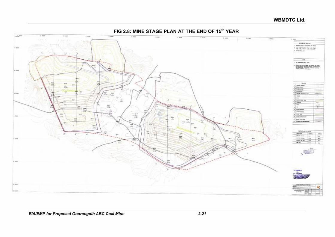
WBMDTC Ltd.
EIA/EMP for Proposed Gourangdih ABC Coal Mine 2-21
FIG 2.8: MINE STAGE PLAN AT THE END OF 15th YEAR

WBMDTC Ltd.
EIA/EMP for Proposed Gourangdih ABC Coal Mine 2-22
FIG 2.9: MINE STAGE PLAN AT THE END OF 27TH YEAR (FINAL STAGE)

WBMDTC Ltd.
EIA/EMP for Proposed Gourangdih ABC Coal Mine 2-23
2.7 PRODUCTION 2.7.1 Calendar program for production
The mine will be operated for three shifts in 330 days per year. The peak production of coal will be 2.5 Million Tonne/annum and of OB removal will be 7.25 Mcum/annum. The calendar programme of coal production, OB removal during life of the mine is tabulated in Table 2.10 along with
stripping ratio.
TABLE 2.10 CALENDAR PROGRAMME OF COAL PRODUCTION, OB REMOVAL,
AND STRIPPING RATIO
Year Gourangidh-A Gourangidh-C Gourangidh-A & C
Coal (Mte)
OB (Mm3)
SR (m3/te)
Coal (Mte)
OB (Mm3)
SR (m3/te)
Coal (Mte)
OB (Mm3)
SR (m3/te)
1. 0.50 2.50 5.00 0.50 2.50 5.00
2. 1.00 2.70 2.70 0.50 2.50 5.00 1.50 5.20 3.47
3. 1.00 2.70 2.70 1.50 4.55 3.03 2.50 7.25 2.90
4. 1.00 2.70 2.70 1.50 4.55 3.03 2.50 7.25 2.90
5. 1.00 2.70 2.70 1.50 4.55 3.03 2.50 7.25 2.90
6. 1.00 2.70 2.70 1.50 4.55 3.03 2.50 7.25 2.90
7. 1.00 2.70 2.70 1.50 4.55 3.03 2.50 7.25 2.90
8. 1.00 2.70 2.70 1.50 4.55 3.03 2.50 7.25 2.90
9. 1.00 2.70 2.70 1.50 4.55 3.03 2.50 7.25 2.90
10. 1.00 2.70 2.70 1.50 4.55 3.03 2.50 7.25 2.90
11. 1.00 2.70 2.70 1.50 4.55 3.03 2.50 7.25 2.90
12. 1.00 2.70 2.70 1.50 4.55 3.03 2.50 7.25 2.90
13. 1.00 2.70 2.70 1.50 4.55 3.03 2.50 7.25 2.90
14. 1.00 2.70 2.70 1.50 4.55 3.03 2.50 7.25 2.90
15. 1.00 2.70 2.70 1.50 4.55 3.03 2.50 7.25 2.90
16. 1.00 2.70 2.70 1.50 4.55 3.03 2.50 7.25 2.90
17. 1.00 2.70 2.70 1.50 4.55 3.03 2.50 7.25 2.90
18. 1.00 2.70 2.70 1.50 4.55 3.03 2.50 7.25 2.90
19. 1.00 2.70 2.70 1.50 4.55 3.03 2.50 7.25 2.90
20. 1.00 2.70 2.70 1.50 4.55 3.03 2.50 7.25 2.90
21. 1.00 2.70 2.70 1.50 4.55 3.03 2.50 7.25 2.90
22. 1.00 2.70 2.70 1.50 4.55 3.03 2.50 7.25 2.90
23. 1.00 2.70 2.70 1.50 4.55 3.03 2.50 7.25 2.90
24. 1.00 2.70 2.70 1.50 4.55 3.03 2.50 7.25 2.90
25. 0.96 2.04 2.12 1.50 4.55 3.03 2.46 6.59 2.68
26. 1.50 4.55 3.03 1.50 4.55 3.03
27. 0.58 1.03 1.79 0.58 1.03 1.79
Total 24.46 66.64 2.72 37.08 112.73 3.04 61.54 179.37 2.91
Source: Table-7.3 of approved Revised Mining Plan, April 2011 Abbreviation : SR = Stripping Ratio

WBMDTC Ltd.
EIA/EMP for Proposed Gourangdih ABC Coal Mine 2-24
2.8 ANTICIPATED LIFE OF THE MINE AND TARGETED CAPACITY The extractable reserves are 61.54 MT (Gourangdih A- 24.46 MT and
Gourangdih C- 37.08 MT). The life of the mine, considering a maximum capacity of 2.5 MTPA coal production, will be 27 years as per approved Revised Mining Plan. The average stripping ratio of the mine works out to 2.91 cum/t as per the calendar programme of excavation.
2.9 DRILLING AND BLASTING PATTERN Due to the location of the project to close proximity of thickly populated
village i.e. Gourangdih and Panuriya, restrictions are anticipated in regard to blasting in this project. For drilling in top OB and partings 160 mm diameter drills have been proposed. For soft and medium hard sand stone and bench height of 12 m, the burden and spacing have been assumed 5 m and 6 m respectively. Consumption of explosive would be about 7 T/day assuming specific consumption of 0.32 kg/m3 in OB. The specific consumption of explosives in coal is adopted as 0.2 kg/m3. Permission from DGMS for sleeping of holes shall be taken, so that advance charging can be done and all required blasting rounds can be completed in the desired time.
Type and Storage of explosives to be used SMS explosives will be used for blasting. It is recommended to provide 2
numbers of magazines of 3 T capacity each for storage of high explosives, cast booster and explosive accessories.
2.10 MODE OF TRANSPORTATION
2.10.1 Transport of Coal
Coal as ROM from the opencast faces will be loaded by 3.2 m3 diesel
hydraulic shovel and 2.5 m3 diesel hydraulic Backhoe onto 60 T coal body rear dumpers for hauling it to coal handling plant. From there, coal will be transported to various consumers across the different states through road or railway depending upon the end user.
2.10.2 Transport of overburden
For open cast operation the top soil will have to be removed first with the
help of 5 m3 backhoe in conjunction with 60 T rear dumpers. It will simultaneously reutilised or stored in top soil dump (referred to as soft overburden in approved revised Mining Plan). The overburden benches will be worked with 5 m3 hydraulic shovel and 60 T dumpers. The OB will be transported to external dumps and later internal dumps.
2.11 MINERAL BENEFICIATION As such, coal beneficiation is not planned at the project site since all the
seams are generally free from any dirt band. Run of Mine will be of non-

WBMDTC Ltd.
EIA/EMP for Proposed Gourangdih ABC Coal Mine 2-25
coking coal of Grade C-F. It will be sold, as produced at the quarry, to various consumers across different states. However, a Coal Handling Plant (CHP) capable of handling 2.5 MTPA coal is proposed for dispatching crushed coal to various consumers.
2.11.1 Description of CHP
This CHP will be located on north side of the Gourangdih C quarry (refer
Fig 2.5 above). The coal handling plant has been considered into two different sections namely, (i) Receiving and crushing complex and (ii) transportation of sized coal from receiving complex up to ground stock pile.
The receiving and crushing complex will consist of a ramp and dumper
unloading platform of 12 m height. Which will facilitate easy and safe movement of 60 T dumper. The ramp, platform and unloading section shall have to be so constructed so that two dumpers can unload coal simultaneously, to achieve the throughput capacity of the plant. The capacity of the crushing complex is proposed as 1000 Tonne Per Hour (TPH) and all the other equipment’s will have to be selected accordingly. Coal will be unloaded by rear discharge dumper into an Apron feeder through self flowing bunker. A twin shaft primary sizer is proposed to be installed at 3.00 m elevation from the ground to receive ROM Coal from the Apron feeder after shale picking & will crush the coal upto the required size. Dust collecting hoppers will be fitted below the Apron feeder. A belt conveyor will receive coal mainly from outlet end of primary sizer as well as from dust collecting hoppers below the Apron feeder & will deliver into a secondary sizer. The conveyor would have 50 m length, 1200 mm width & 1000 TPH capacity. The secondary sizer will be of twin shaft type. It can further crush coal from (-) 300 mm to (-) 50 mm sizes.
A reclaimer conveyor will convey coal from secondary sizer outlet end to the
ground stockpile, from there required crushed coal will be dispatched by truck to various consumers.
2.12 EQUIPMENT AND MACHINERY Types and strength of mining equipment worked out for the targeted annual
production of 2.5 MT of coal and corresponding OB and suited to geo-mining condition of coal and overlying strata is given in Table 2.11.
TABLE 2.11
LIST OF PROPOSED MAJOR HEMM
Sl. No.
Particulars Capacity Total Nos.
A OVERBURDEN
1 Diesel Hydraulic shovel 5 m3 3
2 Diesel Hydraulic Backhoe 5 m3 3
3 Rear Dumper 60 T 36
4 RBH Drill 160 mm 4

WBMDTC Ltd.
EIA/EMP for Proposed Gourangdih ABC Coal Mine 2-26
Sl. No.
Particulars Capacity Total Nos.
5 Dozer with ripper attachment 410 HP 6
Sub Total (A) 52
B COAL (OC)
1 Diesel Hydraulic shovel 3.2 m3 2
2 Diesel Hydraulic Backhoe 2.5 m3 2
3 Rear Dumper 60T 20
4 RBH Drill 160 mm 2
5 Dozer 320 HP 4
Sub Total (B) 30
C RECLAMATION
1 Diesel Hydraulic Backhoe 0.9 m3 1
2 Dozer 410 HP 1
3 Water Sprinkler 28 KL 2
4 Motor Grader 280 HP 1
Sub Total (C) for reclamation 5
D COMMON EQUIPMENTS
1 Pay Loader 2.5 m3 1
2 CA Drill 100-115 mm 1
3 Water sprinkler 28 KL 4
4 Motor grader 280 HP 4
5 Diesel Bowser 2
6 Diesel tanker 2
7 Fork Lift 5 T 1
8 Boom Truck 2
9 Type Handler 6-8 T 2
10 Crane 55 T 1
11 Crane 30 T 1
12 Vibratory compactor 1
Sub Total (D) for common 22
Total (OB + coal + Reclamation + Common)
109
Source: Table 7.4 of approved Revised Mining Plan, April 2011
2.13 SITE SERVICES/ FACILITIES
The proposed mine site infrastructure will consist of the following facilities, as mentioned in Chapters xii and xiii of approved Revised Mining Plan, April 2011.
2.13.1 Buildings 2.13.1.1 Non-Residential Buildings All the non residential buildings will have to be constructed in the vicinity of
OCP. The suitable location will be in the north side of Gourangdih C block

WBMDTC Ltd.
EIA/EMP for Proposed Gourangdih ABC Coal Mine 2-27
as that part is non coal bearing area. These buildings will include following facilities:
Mine Offices & common facilities: Provision has been made for mine
office and common facilities such as dispensary, officers and staff rest house, clubs etc. These buildings have been envisaged as RCC-cum-brick masonry structures over an area of 18000 m2 i.e. on 1.8 ha.
Excavation, E&M Workshop cum Project Store: meant for maintenance,
repairs and storage of raw materials, machineries parts etc. of HEMM, LMV and other Plant & Machineries. The area of both excavation workshop unit and E&M workshop cum Project store will be 18000 m2 each. The area of various shops and facilities are envisaged on the basis of technological & operational requirements.
Sub-Station: One sub-station has been considered to cater for the
requirements of the project & township. This will be brick masonry, RCC beam and slab construction with RCC louvres for ventilation and ducts with proper size for electric cables.
Magazine: 2 numbers of magazine of 3 T capacity each will be provided for
storage of high explosives, cast booster and explosive accessories. Statutory Buildings: The canteen, first aid centre, rest shelter, training
centre, pit head bath etc. will be constructed as per statutory requirement. 2.13.1.2 Residential Buildings The mining manpower requirement for Gourangdih Opencast Mine has
been estimated as 494. The nearest town of Asansol is at 20 kms from the proposed project. Hence, 270 nos. of residential units have been envisaged, assuming around 55% housing satisfaction for the directly employeed manpower of 494. Due to unavailability of suitable land within lease hold area, residential colony and other community/ welfare facilities for the employees are proposed to be located on the north side of the block on non agricultural land. Land required towards this works out to around 20 ha.
2.13.2 Roads & Culverts
There will be colony road, Haul road (3 km) for movement of 60 T dumpers,
Heavy Duty Road (2 kms) for movement of dumpers to workshop for maintenance, Approach Road (2.5 km) to Project & township and Approach Road (2 km) to Magazine located in the south side of the quarry.
2.13.3 Services proposed to be outsourced The following services have been proposed to be outsourced for improved
efficiency in daily operations:
a. Security services

WBMDTC Ltd.
EIA/EMP for Proposed Gourangdih ABC Coal Mine 2-28
b. Canteen services c. Rest house services d. Colony maintenance services e. Biological reclamation services f. Sanitary works
2.13.4 Training For efficient effective and safe operation of the mine, a comprehensive and
punctilious training program for all levels of employees would be conducted by the external agencies, including the equipment manufacturers.
2.13.5 Automation
Availability of accurate information at proper time is backbone for decision making, implementation, efficient management and control of the project. Hence, emphasis will be given on the use of information technology and other modern system as a tool for management. Provisions have been made for Computer systems for maintenance, inventory control, data management, integrated truck despatch system, etc; internet; WAN/LAN support for integrated information system, Surface Mine Communication system for monitoring, control of line function, etc; and Slope stability radars/monitors to predict slope failures etc.
2.14 WATER REQUIREMENT Requirement: Total requirement of water is estimated as 530 KLD (0.14
MGD) for potable and 454 KLD (0.12 MGD) for industrial purpose. Water Source: Source of raw water required for the project and residential
colony shall be Ajay River till the mine seepage water becomes available in sufficient quantity for use. Water from Ajay River is proposed to be stored in bulk reservoir through intake well and pump arrangement at Ajay River. The water shall be treated and stored in Overhead tank for domestic use.
The breakup of the required water for different activities is given in Table
2.12.
TABLE 2.12 WATER REQUIREMENT
(I) Potable Water Demand Consumption
(KLD)
1 Employees (762 manpower mining & ancillary) @ 45 lpd/head 34
2 Colony (for 1350 population, water demand @ 135 lpd/head) 182
3 RR Colony (for 2040 population, water demand @ 135 lpd/head) 275
4 Water requirement for Peripheral villages (Lumpsum) 39
Total 530
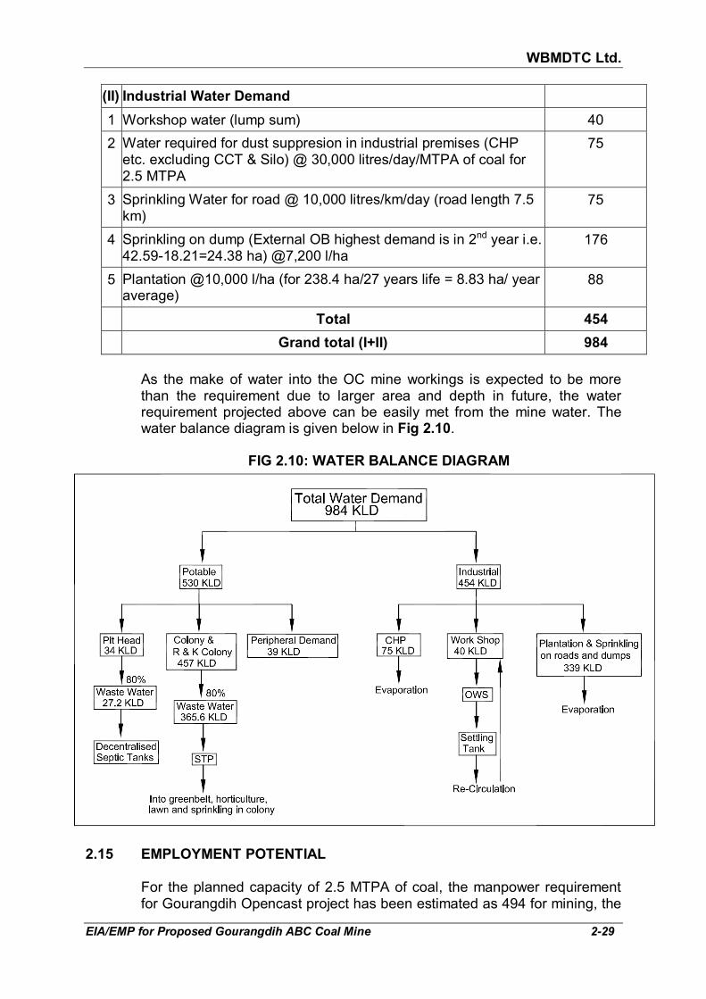
WBMDTC Ltd.
EIA/EMP for Proposed Gourangdih ABC Coal Mine 2-29
(II) Industrial Water Demand
1 Workshop water (lump sum) 40
2 Water required for dust suppresion in industrial premises (CHP etc. excluding CCT & Silo) @ 30,000 litres/day/MTPA of coal for 2.5 MTPA
75
3 Sprinkling Water for road @ 10,000 litres/km/day (road length 7.5 km)
75
4 Sprinkling on dump (External OB highest demand is in 2nd year i.e. 42.59-18.21=24.38 ha) @7,200 l/ha
176
5 Plantation @10,000 l/ha (for 238.4 ha/27 years life = 8.83 ha/ year average)
88
Total 454
Grand total (I+II) 984
As the make of water into the OC mine workings is expected to be more
than the requirement due to larger area and depth in future, the water requirement projected above can be easily met from the mine water. The water balance diagram is given below in Fig 2.10.
FIG 2.10: WATER BALANCE DIAGRAM
2.15 EMPLOYMENT POTENTIAL
For the planned capacity of 2.5 MTPA of coal, the manpower requirement
for Gourangdih Opencast project has been estimated as 494 for mining, the
WBMDTC Ltd.
EIA/EMP for Proposed Gourangdih ABC Coal Mine 2-30
break-up of which is given in the Table 2.13. In addition to these, manpower to the tune of 268 persons is also estimated for ancillary jobs. Thus, 762 persons will be required to run the project.
TABLE 2.13
ESTIMATED MANPOWER REQUIREMENT FOR 2.5 MTPA
Sl. No. Particulars Strength (nos)
I Operation
A OB 180
B Coal 68
C Reclamation 12
D Common 23
Sub. Total (I) 283
II Maintenance 42
III CHP & Despatch 23
IV Common Manpower
A Excavation supervision 8
B E&M supervision 3
C E&M Maintenance, w/shop, Colony 16
D Other operations 31
E Planning office 2
F Transport
G Mining safety, Despatches & quality control 13
H Training centre
I Project office 7
J Finance & Accounts 7
K Watch & Word 8
L Personnel welfare 1
M Stores 8
N Civil & Town Administration 3
O Medical & Sanitation 5
P Water supply 16
Q Survey 12
R Communication 2
Sub Total (IV) 142
V Environment 4
Total (I+II+III+IV+V) 494

WBMDTC Ltd.
EIA/EMP for Proposed Gourangdih ABC Coal Mine 2-31
The man power calculation has been made based on 330 days of annual working. Services for security, canteen, rest house, colony maintenance, biological reclamation and sanitation are proposed to be outsourced.
2.16 POWER REQUIRMENT
The total power requirement for the proposed mine will be about 5275 KW, which will be supplied by from West Bengal State Electricity Board (WBSEB) through 33 KV overhead line. The main sub station shall be located at the dip side of quarry so that two independent 11 KV feeders can be there for Gourangdih A and C respectively. For power backup, 5790 KVA diesel generator are proposed.
2.17 PROPOSED DIVERSIONS
Existing power lines diversion: No HT Power Line diversion is involved.
Existing power lines, most of which are 11 KV single circuit feeders having 2-3 power line pole, will have to be shifted at a very later stage. The diversion shall be done after obtaining the neccessary approval from the concerned electricity board.
Existing Roads diversion: There are two existing roads, which will be
diverted as follow:
i.) Asansol-Gourangdih road connecting Runakuraghat, passes over the eastern flank of Gourangidh-C quarry. This road is proposed to be diverted towards further east of the quarry.
ii.) Rupnarayanpur-Gourangdih road, passes over western portion of the
Quarry-A, which is proposed to be diverted towards further west of the quarry.

WBMDTC Ltd.
EIA/EMP for Proposed Gourangdih ABC Coal Mine 3-1
CHAPTER 3
DESCRIPTION OF THE ENVIRONMENT
3.1 GENERAL For the purpose of assessing impacts of any development project, the
baseline status of environmental factors in the project area and its surrounding is to be established.
3.1.1 Sources of environmental data The baseline information with respect to micro-meteorological data,
ambient air quality, water quality, noise levels, soil quality and traffic density have been generated by NABL accredited M/s Min Mec R&D Laboratory, New Delhi (NABL certificate no. TC-6337). The long term meteorological data recorded at the nearest IMD station, Bankura MO was collected and micro-meteorological data was recorded at the site using an automatic weather monitoring station. Apart from these, secondary data have been collected from Registrar of Census 2011, Central Ground Water Board/ Authority, Survey of India Open Series Map, satellite images from Google Earth, information from Forest Department, etc.
The generation of primary data as well as collection of secondary data and
information from the site and its surroundings was carried out during winter season from 1st December 2017 to 28th February 2018. The data was generated after the receipt of the Terms of Reference from Ministry of Environment, Forests & Climate Change vide letter no. J-11015/80/2017.IA-II(M) dated 29th September, 2017 in line with the requirements of the MoEF&CC.
3.1.2 Study area
For the description of baseline environmental scenario, the lease area has been considered as the “core zone”. The 10 km radius around the proposed project forms the “buffer zone” i.e. the anticipated area of impact. The core zone and the buffer zone together have been termed as “study area”. The core zone falls within Panuriya (or Punuria), Kantapahari, Jamgram, Shibdhawra (or Shibdhara), Banddhawra, Lalbandh, Gourangdih and Bhuiapara, under Barabani CD Block of District Paschim Bardhman, West Bengal. Study area covers various sub-districts such as Salanpur, Barabani, Jamuria of District Paschim Bardhman and Jamtara & Nala sub-district of District Jamtara. The study area can be seen in Fig 3.1.
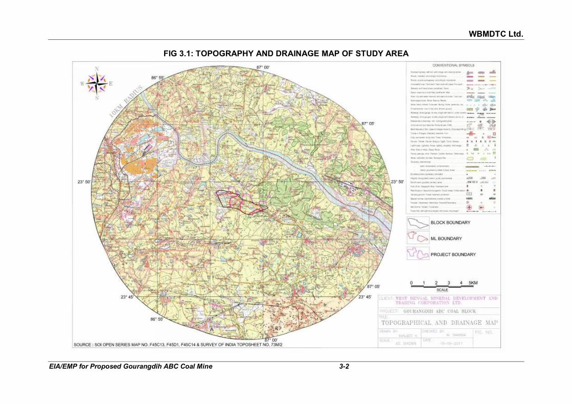
WBMDTC Ltd.
EIA/EMP for Proposed Gourangdih ABC Coal Mine 3-2
FIG 3.1: TOPOGRAPHY AND DRAINAGE MAP OF STUDY AREA
WBMDTC Ltd.
EIA/EMP for Proposed Gourangdih ABC Coal Mine 3-3
3.2 TOPOGRAPHY AND DRAINAGE 3.2.1 Topography Core zone: The topography has gentle undulations. General slope of
southern part of the project is towards south and northern part is towards north. In the north- western part, coarse grained sandstones have given rise to small mounds.The elevation as per approved Revised Mining Plan varies between 135 m a.m.s.l to 174 m a.m.s.l. Old quarries are present in western portion (Khoirabad quarry) and eastern portion (Debu quarry) of the project. The quarries had been worked in the past by other companies and were abandoned.
Buffer zone: In Fig 3.1, one can see that the topography of the central
portion of the study area, between project area and Ajay river is sloping towards Ajay river in north, which lies 2.2 km from the project. The part of the study area which lies north of the Ajay River slopes southwards. The area south of the project that is bottom half of the study area is sloping towards Noniya Jhor Nala.
The surface elevation varies from minimum 93 m above MSL (near village
Beldanga on bank of Ajay River) to maximum 180 m above MSL (near Alkusha village). The area is rich in coal reserves, therefore, there are several coal blocks present in study area. These have disturbed the topography by formation of pits and dumps.
3.2.2 Drainage Core zone: The drainage of northern portion of the project area is towards
Ajay river, which lies at a distance of 2.2 km (nearest point). The river flows from north-west to east direction in North of the project. In this portion of the project, as per Survey of India Open Series Map, three first order seasonal drains are originating and ultimately joining Ajay river. These nalas can be seen west and north of Shibdhara settlement and east of Bhatar Colony.
The drainage of the southern portion of the area is controlled by a seasonal
nala i.e. Noniya Jhor which is a tributary of Damodar river. As per Survey of India Open Series Map, a first order drain is originating south of Panuriya and joining Noniya Jhor. Village ponds as well as old abandoned open cast quarries filled with water are present in the core zone. The drainage map of the study area is given in Fig 3.1.
Buffer Zone: Ajay river flows in north-west to east direction which controls the drainage system of major portion of the buffer zone. While, Noniya Jhor, a seasonal nala controls drainage system of the Southern portion of the study area. After flowing through study area and Asansol in the south, Noniya Jhor is drained into the Damodar River. Two tributaries of Ajay river namely, Suriapani Jhor and Punta Khal are also following in the NE and SE direction, respectively, from the project.
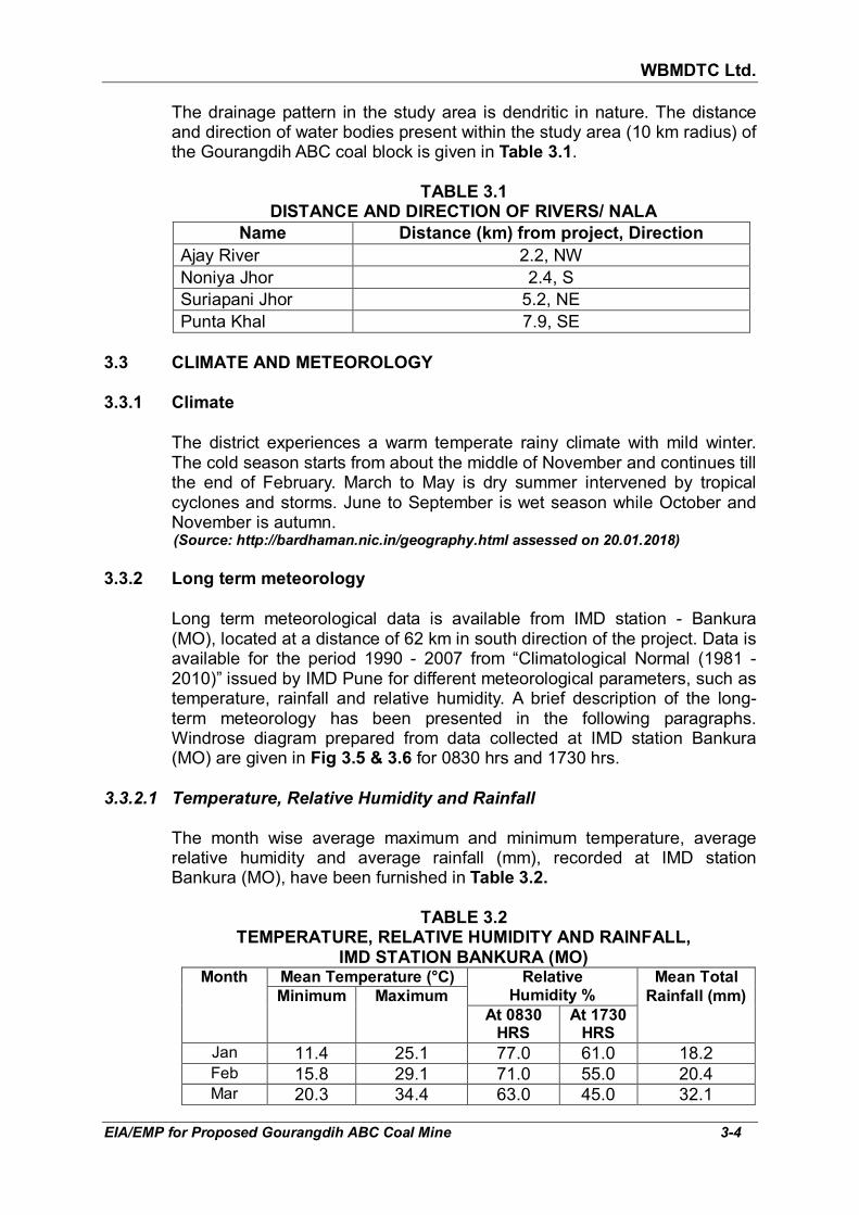
WBMDTC Ltd.
EIA/EMP for Proposed Gourangdih ABC Coal Mine 3-4
The drainage pattern in the study area is dendritic in nature. The distance and direction of water bodies present within the study area (10 km radius) of the Gourangdih ABC coal block is given in Table 3.1.
TABLE 3.1
DISTANCE AND DIRECTION OF RIVERS/ NALA
Name Distance (km) from project, Direction
Ajay River 2.2, NW Noniya Jhor 2.4, S Suriapani Jhor 5.2, NE Punta Khal 7.9, SE
3.3 CLIMATE AND METEOROLOGY
3.3.1 Climate
The district experiences a warm temperate rainy climate with mild winter.
The cold season starts from about the middle of November and continues till the end of February. March to May is dry summer intervened by tropical cyclones and storms. June to September is wet season while October and November is autumn. (Source: http://bardhaman.nic.in/geography.html assessed on 20.01.2018)
3.3.2 Long term meteorology
Long term meteorological data is available from IMD station - Bankura
(MO), located at a distance of 62 km in south direction of the project. Data is available for the period 1990 - 2007 from “Climatological Normal (1981 - 2010)” issued by IMD Pune for different meteorological parameters, such as temperature, rainfall and relative humidity. A brief description of the long-term meteorology has been presented in the following paragraphs. Windrose diagram prepared from data collected at IMD station Bankura (MO) are given in Fig 3.5 & 3.6 for 0830 hrs and 1730 hrs.
3.3.2.1 Temperature, Relative Humidity and Rainfall The month wise average maximum and minimum temperature, average
relative humidity and average rainfall (mm), recorded at IMD station Bankura (MO), have been furnished in Table 3.2.
TABLE 3.2
TEMPERATURE, RELATIVE HUMIDITY AND RAINFALL, IMD STATION BANKURA (MO)
Month Mean Temperature (°C) Relative Humidity %
Mean Total
Minimum Maximum Rainfall (mm)
At 0830 HRS
At 1730 HRS
Jan 11.4 25.1 77.0 61.0 18.2 Feb 15.8 29.1 71.0 55.0 20.4 Mar 20.3 34.4 63.0 45.0 32.1

WBMDTC Ltd.
EIA/EMP for Proposed Gourangdih ABC Coal Mine 3-5
Month Mean Temperature (°C) Relative Humidity %
Mean Total
Minimum Maximum Rainfall (mm)
Apr 24.9 37.3 69.0 53.0 40.7 May 26.3 37.4 72.0 59.0 100.9 Jun 26.6 35.7 79.0 72.0 271.0 Jul 26.4 32.8 85.0 82.0 363.0 Aug 26.3 32.5 86.0 82.0 352.3 Sep 25.5 32.4 87.0 83.0 253.4 Oct 23.3 31.8 84.0 79.0 86.8 Nov 17.9 29.4 81.0 71.0 16.0 Dec 12.9 26.2 80.0 67.0 9.1
Annual Average
21.5 32.0 78 67 Total = 1564
Source: Climatological Normal (1980 - 2010)
From Table 3.2, the following conclusions can be drawn:
1. Temperature: The monthly mean of minimum temperatures ranges from 11.4°C in January to 26.6°C in June. While the monthly mean of maximum temperature ranges from 25.1°C in January to 37.4°C in May. The monthly average of maximum and minimum temperatures is given in Fig 3.2.
2. Relative Humidity: The relative humidity at 08:30 hrs ranges between
63% in March to 87% in September, while the relative humidity at 17:30 hrs varies from 45% in March to 83% in September. The average monthly relative humidity is shown in Fig 3.3.
3. Rainfall: It can be seen that, June to September are the months of
heaviest rainfall, while October to May are of low rainfall. The annual rainfall varies from 9.1 mm in December to 363.0 mm in July. The annual average is 1564 mm. Monthly average rainfall for the period of 1990 to 2007 is shown in Fig 3.4.

WBMDTC Ltd.
EIA/EMP for Proposed Gourangdih ABC Coal Mine 3-6
Wind speed and flow pattern To demonstrate the wind flow pattern of the study area, Windrose diagram
of IMD station at Bankura (MO) have been prepared in Fig 3.5 and 3.6 for 0830 hrs and 1730 hrs, respectively as obtained for the data recorded for a period of 1990 to 2007.

WBMDTC Ltd.
EIA/EMP for Proposed Gourangdih ABC Coal Mine 3-7
FIG 3.5: WINDROSE DIAGRAM AT IMD STATION BANKURA (MO) AT 8:30 HRS
FIG 3.6: WINDROSE DIAGRAM AT IMD STATION BANKURA (MO) AT 17.30 HRS

WBMDTC Ltd.
EIA/EMP for Proposed Gourangdih ABC Coal Mine 3-8
3.4 MICRO-METEOROLOGICAL SURVEY On-site monitoring was undertaken from 01.12.2017 to 28.02.2018 for
various meteorological parameters i.e. wind speed, wind direction, ambient air temperature, relative humidity, etc. in order to generate the site-specific data. The micro-meteorological station was installed at a height of about 3 meters from ground level free from any obstruction in the core zone. Hourly micro-meteorological data was recorded at the site for a period of 3 months. Average, minimum and maximum values of the recorded data are given in Table 3.3.
TABLE 3.3
SUMMARY OF MICRO-METEOROLOGICAL DATA
Particulars Minimum Maximum Average
Temperature (°C) 10.12 30.34 22.45
Relative humidity (%) 33.70 89.90 65.10
Wind speed (km/hr) Calm 12.24 3.53
Predominant wind direction N (35.17% of readings including calm, 18.22% excluding calm)
The above table depicts that during monitoring season, temperature ranged
between 10.12°C to 30.34°C and relative humidity varied from 33.70% to 89.90%. The wind speed varied from Calm to 12.24 km/hr and the predominant wind direction was found to be from North with 35.17% of the instances. The daily average of micro-meteorological data, prepared from the hourly recorded readings is given in Annexure V. The wind frequency table is given in Table 3.4 and the corresponding windrose diagram is shown in Fig 3.7.
TABLE 3.4
WIND FREQUENCY OF MONITORED DATA
Direction
from
% of readings in different ranges of wind speed (km/hr)
Calm 1.8 - 5 5 - 10 10-15 15-20 > 20 Total Ex-Calm
DAY TIME (6 HRS TO 17 HRS) WIND SPEED (km/hr)
E 0.00 0.09 0.00 0.00 0.00 0.00 0.09 0.09 ENE 0.19 0.37 0.56 0.09 0.00 0.00 1.21 1.02 NE 0.00 3.93 3.75 0.00 0.00 0.00 7.68 7.68 NNE 0.19 0.75 0.37 0.00 0.00 0.00 1.31 1.12 N 18.54 9.83 5.81 0.28 0.00 0.00 34.46 15.92 NNW 2.81 3.37 4.03 0.00 0.00 0.00 10.21 7.40 NW 0.94 6.18 2.06 0.75 0.00 0.00 9.93 8.99 WNW 0.00 0.09 0.09 0.00 0.00 0.00 0.18 0.18 W 3.65 10.02 5.90 1.03 0.00 0.00 20.60 16.95 WSW 1.31 0.00 0.00 0.00 0.00 0.00 1.31 0.00 SW 1.31 0.00 0.09 0.00 0.00 0.00 1.40 0.09 SSW 0.56 0.00 0.00 0.00 0.00 0.00 0.56 0.00 S 3.09 3.37 3.84 0.00 0.00 0.00 10.30 7.21

WBMDTC Ltd.
EIA/EMP for Proposed Gourangdih ABC Coal Mine 3-9
Direction
from
% of readings in different ranges of wind speed (km/hr)
Calm 1.8 - 5 5 - 10 10-15 15-20 > 20 Total Ex-Calm
SSE 0.00 0.19 0.00 0.00 0.00 0.00 0.19 0.19 SE 0.00 0.00 0.00 0.00 0.00 0.00 0.00 0.00 ESE 0.00 0.09 0.28 0.19 0.00 0.00 0.56 0.56
Total 32.59 38.28 26.78 2.34 0.00 0.00 99.99 67.40
NIGHT TIME (18 HRS TO 5 HRS) WIND SPEED (km/hr) E 0.00 0.09 0.00 0.00 0.00 0.00 0.09 0.09 ENE 0.00 0.19 0.28 0.00 0.00 0.00 0.47 0.47 NE 0.00 3.26 4.19 0.00 0.00 0.00 7.45 7.45 NNE 0.00 1.03 0.09 0.00 0.00 0.00 1.12 1.12 N 15.38 14.07 6.15 0.28 0.00 0.00 35.88 20.50 NNW 3.82 3.36 3.73 0.00 0.00 0.00 10.91 7.09 NW 1.03 5.31 2.89 0.37 0.00 0.00 9.60 8.57 WNW 0.19 0.28 0.00 0.00 0.00 0.00 0.47 0.28 W 5.03 9.41 3.45 1.12 0.00 0.00 19.01 13.98 WSW 1.30 0.00 0.00 0.00 0.00 0.00 1.30 0.00 SW 1.12 0.37 0.00 0.00 0.00 0.00 1.49 0.37 SSW 0.75 0.00 0.00 0.00 0.00 0.00 0.75 0.00 S 3.36 4.10 3.36 0.19 0.00 0.00 11.01 7.65 SSE 0.00 0.09 0.00 0.00 0.00 0.00 0.09 0.09 SE 0.00 0.00 0.00 0.00 0.00 0.00 0.00 0.00 ESE 0.09 0.19 0.09 0.00 0.00 0.00 0.37 0.28
Total 32.07 41.75 24.23 1.96 0.00 0.00 100.01 67.94
COMPOSITE (DAY+ NIGHT) E 0.00 0.09 0.00 0.00 0.00 0.00 0.09 0.09 ENE 0.09 0.28 0.42 0.05 0.00 0.00 0.84 0.75 NE 0.00 3.60 3.97 0.00 0.00 0.00 7.57 7.57 NNE 0.09 0.89 0.23 0.00 0.00 0.00 1.21 1.12 N 16.95 11.96 5.98 0.28 0.00 0.00 35.17 18.22 NNW 3.32 3.36 3.88 0.00 0.00 0.00 10.56 7.24 NW 0.98 5.74 2.48 0.56 0.00 0.00 9.76 8.78 WNW 0.09 0.19 0.05 0.00 0.00 0.00 0.33 0.24 W 4.34 9.72 4.67 1.07 0.00 0.00 19.80 15.46 WSW 1.31 0.00 0.00 0.00 0.00 0.00 1.31 0.00 SW 1.21 0.19 0.05 0.00 0.00 0.00 1.45 0.24 SSW 0.65 0.00 0.00 0.00 0.00 0.00 0.65 0.00 S 3.22 3.74 3.60 0.09 0.00 0.00 10.65 7.43 SSE 0.00 0.14 0.00 0.00 0.00 0.00 0.14 0.14 SE 0.00 0.00 0.00 0.00 0.00 0.00 0.00 0.00 ESE 0.05 0.14 0.19 0.09 0.00 0.00 0.47 0.42
Total 32.30 40.04 25.52 2.14 0.00 0.00 100.00 67.70 Note:- Calm is cut off at wind speed <1.8 km/hr as per CPCB, the deviation from a sum
total of 100% is due to rounding off of individual directions.

WBMDTC Ltd.
EIA/EMP for Proposed Gourangdih ABC Coal Mine 3-10
FIG 3.7: WINDROSE DIAGRAM OF MONITORED DATA

WBMDTC Ltd.
EIA/EMP for Proposed Gourangdih ABC Coal Mine 3-11
3.5 AMBIENT AIR QUALITY 3.5.1 Ambient air sampling period The ambient air quality monitoring was conducted from 1st December 2017
to 28th February 2018 at eight stations. 3.5.2 Location of ambient air sampling stations
The air sampling stations were established in and around the core and
buffer zone to study the present ambient air quality. Two stations were established in project area and six stations in the buffer zone on the basis of predominant directions, location of habitation, sensitive receptors, industrial activity, etc. A study of the composite wind frequency in Table 3.4, shows that the first three predominant wind direction are from North, West & North-West. A map of the study area showing the locations of these sampling stations, as mentioned in Table 3.5, is presented in Fig 3.8.
TABLE 3.5
LOCATION OF AIR SAMPLING STATIONS
Station Code
Location Distance (km)
Direction Reason for selection of station for coal Mine
A1 Core Zone (Block A)
Within Core Zone
- Core area, where mining activity shall be done
A2 Core Zone (Block C)
Within Core Zone
- Core area, where mining activity shall be done
A3 Gourangdih 0.35 Between Block A and C.
In between of Block A and Block C where mining activities are not proposed due to thickly populated area
A4 Kantapahari 0.3 SE 3rd predominant downwind direction
A5 Kashidanga 1.5 E 2nd predominant downwind direction and crosswind of 1st predominant
A6 Kashidangal 0.2 N 1st predominant upwind direction and crosswind of 2nd predominant
A7 Baradang 0.9 S 1st predominant downwind direction and crosswind of 2nd predominant
A8 Aliganja 1.2 N 1st predominant up wind direction and crosswind of 2nd predominant
WBMDTC Ltd.
EIA/EMP for Proposed Gourangdih ABC Coal Mine 3-12
3.5.3 Sampling schedule and air quality parameters The study was carried out for 3 months with a frequency of twice a week at
each site. 24-hour average samples for PM10, PM2.5, SO2 and NO2 were collected from each station. These samples were analyzed in laboratory by adopting the methods specified in National Ambient Air Quality Standards. The following air pollution parameters were monitored during the sampling periods.
3.5.4 Methodology
Respirable Particulate Matter (PM10) The sampling of ambient air was performed with Respirable Dust Sampler
which is primarily a High Volume Sampler fitted with a cyclone separator for pre-separation of particles larger than 10 micron diameter. Air exiting from the separator is drawn at a measured rate through the separator followed by a pre-weighed glass fibre sheet of 20 cm x 25 cm sizes (Whatman, EPM-2000 or equivalent). The RPM concentrations are determined gravimetrically from the average airflow rate, sampling period and the mass of particulate matter collected over the GF filter surface.
Fine Particulate Matter (PM2.5) The sampling of ambient air was performed with the fine particulate sampler
for particle less than 2.5 microns diameter. The PM2.5 concentration are determined gravimetrically from the average air flow rate, sampling period and the mass of the particulate matter collected over the PTFE filter surface.
Sulphur dioxide (SO2) The sampling of ambient air for evaluating SO2 concentrations was
performed with a Multigas Sampler, using the vacuum created by the Respirable Dust Sampler for drawing the air samples through the impingers. Air is drawn at a measured and controlled rate of 300 ml/min through a solution of sodium tetra-chloromercurate.
After completion of sampling, the used absorbing reagent is treated with
dilute solutions of sulfamic acid, formaldehyde and para rosaniline hydrochloride. The absorbance of the intensely coloured para rosaniline methyl sulphonic acid is measured and the amount of SO2 in the sample is computed from graphs prepared with standard solutions. The ambient SO2 concentrations were computed from the amount of SO2 collected and the volume of air sampled.
Oxides of Nitrogen (NO2) The sampling of ambient air for evaluating NO2 concentrations was
performed with a Multigas Sampler, using the vacuum created by the Respirable Dust Sampler for drawing the air samples through the impingers.
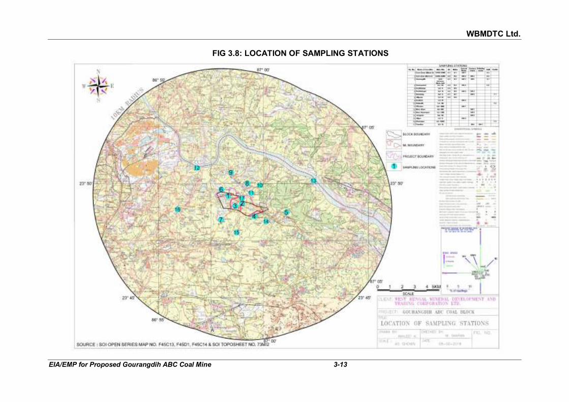
WBMDTC Ltd.
EIA/EMP for Proposed Gourangdih ABC Coal Mine 3-13
FIG 3.8: LOCATION OF SAMPLING STATIONS

WBMDTC Ltd.
EIA/EMP for Proposed Gourangdih ABC Coal Mine 3-14
Air is drawn at a measured and controlled rate of about 300 ml/minute through an orifice-tipped impinger containing solutions of sodium hydroxide and sodium arsenite. After completion of the sampling, an aliquot of the used absorbing solution was treated with solutions of H2O2, sulphanilamide and NEDA. The nitrite ion present in the impinger was calculated from the absorbance of the resulting solution and from the graphs prepared with standard solutions. The ambient NO2 concentrations were computed from the total nitrite ion present in the impingers, overall efficiency of the impinger and the procedure, and the volume of air sampled.
A summary of the methodology is given in Table 3.6.
TABLE 3.6 PROCEDURE FOR DETERMINING VARIOUS AIR QUALITY PARAMETERS
Parameters Testing Procedure
PM 10 Respirable Dust Sampler (RDS)
PM 2.5 Fine particulate sampler (FPS)
SO2 Absorption in Sodium Tetra Chloro-mercurate followed by Colorimetric estimation using P-Rosaniline hydrochloride and Formaldehyde (IS:5182 (Part 2):2001)
NO2 Absorption in dil. NaOH and then estimated colorimetrically with sulphanilamide, NEDA and Hydrogen Peroxide (IS:5182 (Part 6): 2006)
The summarised results of the air quality studies are given in Table 3.7 and
the details are given in the form of Annexure VI. To compare the results of monitored data, National Ambient Air Quality Standard (NAAQS) are given in Annexure VII.
TABLE 3.7
AMBIENT AIR QUALITY (DEC, 2017 TO FEB 2018)
Sl. No. Location 24 hourly average concentration in µg/m3
Min Max Avg. 98% tile
Min Max Avg. 98% tile
PM10 PM2.5
A1 Core Zone (Block A) 55.0 69.5 62.0 68.5 29.8 39.9 35.1 39.7
A2 Core Zone (Block C) 51.8 64.9 58.7 64.9 28.4 37.5 33.3 37.3
A3 Gourangdih 58.3 74.2 67.0 74.2 33.6 42.9 38.4 42.7
A4 Kantapahari 47.2 61.5 55.3 61.5 26.6 36.4 31.5 36.2
A5 Kashidanga 60.1 78.0 68.6 77.7 34.2 45.3 40.2 45.2
A6 Kashidangal 45.0 59.8 52.6 59.7 24.6 35.6 29.8 34.3
A7 Baradang 60.3 69.7 64.4 68.9 32.3 39.8 35.9 39.5
A8 Aliganja 45.9 63.9 54.8 63.2 25.3 36.7 30.8 36.7
Standards as per NAAQS 2009
100 60

WBMDTC Ltd.
EIA/EMP for Proposed Gourangdih ABC Coal Mine 3-15
Location 24 hourly average concentration in µg/m3
SO2 NO2
Min Max Avg. 98% tile
Min Max Avg. 98% tile
A1 Core Zone (Block A) 9.4 11.6 10.5 11.4 11.5 13.4 12.7 13.4
A2 Core Zone (Block C) 7.8 9.4 8.7 9.4 9.9 12.1 10.9 12.0
A3 Gourangdih 8.9 11.1 10.0 11.0 11.1 13.0 12.0 13.0
A4 Kantapahari 6.8 9.0 7.9 8.9 12.1 15.8 14.0 15.7
A5 Kashidanga 10.0 12.1 11.0 12.0 12.6 16.7 14.4 16.4
A6 Kashidangal 6.3 7.9 7.1 7.9 9.0 10.8 9.9 10.8
A7 Baradang 9.4 10.6 10.1 10.5 12.9 15.0 13.9 14.9
A8 Aliganja 6.3 7.9 7.1 7.9 8.3 10.9 9.6 10.9
Standards as per NAAQS 2009
80 80
Heavy metals were analysed using ICP for one Respirable Dust Sample of
core zone after digestion. The results are shown in Table 3.8.
TABLE 3.8 HEAVY METALS TEST RESULT IN AIR SAMPLE OF CORE ZONE
Parameter Protocol Core Zone NAAQS2009
Mercury (as Hg), µg/m3 IS 3025 (Part-2) 0.0049 -
Lead (as Pb), µg/m3 IS 3025 (Part-2) 0.0377 1.0
Chromium (as Cr), µg/m3 IS 3025 (Part-2) 0.0013 -
Arsenic (as As), µg/m3 IS 3025 (Part-2) 0.0008 0.006
Nickel (as Ni), µg/m3 IS 3025 (Part-2) 0.0023 0.02
Manganese(as Mn), µg/m3 IS 3025 (Part-2) 0.1552 -
Selenium (as Se), µg/m3 IS 3025 (Part-2) 0.0020 -
Cadmium (as Cd), µg/m3 IS 3025 (Part-2) 0.0013 -
Silver (as Ag), µg/m3 IS 3025 (Part-2) 0.0066 -
Zinc (as Zn), µg/m3 IS 3025 (Part-2) 0.0745 - Source : MMRDL’s test report
3.6 NOISE ENVIRONMENT 3.6.1 Monitoring locations Ambient noise levels were measured at eight locations in and around the
site using a digital sound level meter. Locations of noise monitoring stations of Gourangdih ABC coal mine is given in Fig 3.8 and Table 3.9.
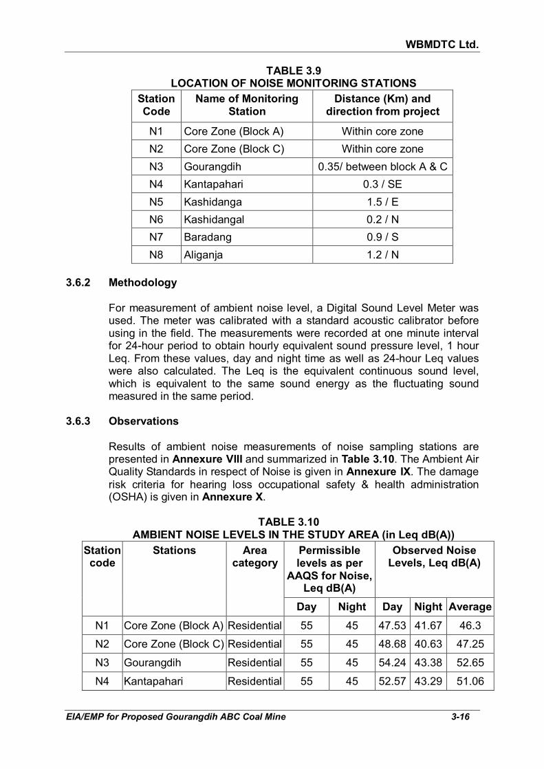
WBMDTC Ltd.
EIA/EMP for Proposed Gourangdih ABC Coal Mine 3-16
TABLE 3.9 LOCATION OF NOISE MONITORING STATIONS
Station Code
Name of Monitoring Station
Distance (Km) and direction from project
N1 Core Zone (Block A) Within core zone
N2 Core Zone (Block C) Within core zone
N3 Gourangdih 0.35/ between block A & C
N4 Kantapahari 0.3 / SE
N5 Kashidanga 1.5 / E
N6 Kashidangal 0.2 / N
N7 Baradang 0.9 / S
N8 Aliganja 1.2 / N 3.6.2 Methodology For measurement of ambient noise level, a Digital Sound Level Meter was
used. The meter was calibrated with a standard acoustic calibrator before using in the field. The measurements were recorded at one minute interval for 24-hour period to obtain hourly equivalent sound pressure level, 1 hour Leq. From these values, day and night time as well as 24-hour Leq values were also calculated. The Leq is the equivalent continuous sound level, which is equivalent to the same sound energy as the fluctuating sound measured in the same period.
3.6.3 Observations
Results of ambient noise measurements of noise sampling stations are
presented in Annexure VIII and summarized in Table 3.10. The Ambient Air Quality Standards in respect of Noise is given in Annexure IX. The damage risk criteria for hearing loss occupational safety & health administration (OSHA) is given in Annexure X.
TABLE 3.10
AMBIENT NOISE LEVELS IN THE STUDY AREA (in Leq dB(A))
Station code
Stations Area category
Permissible levels as per
AAQS for Noise, Leq dB(A)
Observed Noise Levels, Leq dB(A)
Day Night Day Night Average
N1 Core Zone (Block A) Residential 55 45 47.53 41.67 46.3
N2 Core Zone (Block C) Residential 55 45 48.68 40.63 47.25
N3 Gourangdih Residential 55 45 54.24 43.38 52.65
N4 Kantapahari Residential 55 45 52.57 43.29 51.06

WBMDTC Ltd.
EIA/EMP for Proposed Gourangdih ABC Coal Mine 3-17
Station code
Stations Area category
Permissible levels as per
AAQS for Noise, Leq dB(A)
Observed Noise Levels, Leq dB(A)
Day Night Day Night Average
N5 Kashidanga Residential 55 45 51.9 43.76 50.46
N6 Kashidangal Residential 55 45 46.76 40.61 45.5
N7 Baradang Residential 55 45 49.51 43.99 48.32
N8 Aliganja Residential 55 45 48.38 43.09 47.22 Source : MMRDL’s report no. MMN/02-2018/06, dated 12/02/2018
The noise levels were measured at eight stations located near residential
area, which varied between 46.76 to 54.24 dB(A) during day time and 40.61 to 43.99 dB(A) during night time. It is, therefore, concluded that the noise levels in the study area are within the limits prescribed by National Ambient Air Quality Standards for Noise.
3.7 WATER RESOURCES 3.7.1 Surface water The drainage of the project area and buffer zone has been covered in
Section 3.2.2 earlier. Ajay river: River Ajay originates from a small hill about 300 m high,
southwest of Munger in Bihar. It then flows through Jharkhand and enters West Bengal at Simjuri, near Chittaranjan. It forms the border between Burdwan and Birbhum districts and finally joins the Bhagirathi River near Katwa town of Burdwan. Total length of the Ajay river is 288 km out of which 152 km is in West Bengal. The important tributaries of Ajay are Pathro and Jayanti in Jharkhand, Hinglow in Birbhum and Kunur in Burdwan district of West Bengal. There is a barrage across river Ajay constructed by Govt. of Jharkhand at Sikatia. The floods of this river are flashy and of short duration.
There are some pockets in the Ajay-Kunur catchment which suffer from
frequent inundation. Large areas of Burdwan, Birbhum and Murshidabad districts experience inundation due to drainage congestion whenever flood of the Ajay coincides with those of the Mayurakshi and Dwarka. A dam has been constructed over the tributary Hinglow for the purpose of irrigation in some parts of Birbhum district. The total catchment area of this Sub basin is 6,093 sq.km. The nearest gauge from project, at a distance of 75 km on River Ajay, is Gheropara which recorded a seasonal maximum level of 38.40 m against Preliminary Danger levels(PDL) at 38.42 m on day 12th August, 2016. (source: Annual Flood Report 2016 of West Bengal).

WBMDTC Ltd.
EIA/EMP for Proposed Gourangdih ABC Coal Mine 3-18
3.7.2 Ground Water 3.7.2.1 Hydrogeology of Bardhaman district
(Source:- Ground Water Information Booklet of Bardhaman District, WB from http://cgwb.gov.in/District_Profile/WestBangal/Barddhaman.pdf accessed on 10.05.2018)
In the major part of the district, ground water occurs in thick unconsolidated
Quaternaries & Tertiary deposited under fluviatile environment; the sand and/or gravel in different proportions of this formation constitute the main aquifer and they occur down to 295 m bgl in the central and eastern part of the district. Deeper aquifers occurs under semi-confined to confined condition.
Ground water in Palaeozoic- Mesozoic -Tertiary sequence of Gondwana
Super group of sedimentaries occurs under both confined and unconfined condition down to 150.35 m bgl.
Ground water in the extreme north western small part of Salanpur Block
occupied by the Archaean metamorphics, occurs down to a depth of about 82 m bgl under confined and unconfined condition down to 150.36 m bgl. It mainly occurs under unconfined condition in the dug well zone and under semi-confined to confined condition in the deeper horizons. Depth to water level in pre monsoon period (2006) varies from 1.43 to 19.03 m bgl whereas in post monsoon it varies from 1.03 to 31.00 m bgl.
Aquifer Characteristics : Tube wells in the central & eastern part of the
district constructed tapping both semi-confined and confined aquifers are characterised generally as medium duty (50-150 m3/hr) to heavy duty (>150 m3/hr) yield with nominal draw down of 4-5 m. Transmissivity (T) values ranges from 30.77-1700 m2/day and storativity ranges from 2.0X10⁻⁴. The aquifers of Gondwana sediment and archaean metamorphics shows T values ranging from 40-50 m2/day and Storativity value is about 14X10-4.
The dynamic ground water resources of Bardhman district has been
estimated jointly by CGWB and SWID, Government of West Bengal, following the norms laid down by GEC 1997 methodology and projected as on 31.03.2004. By keeping view on to supply water requirement up to 25 years for domestic & industrial water, the Stage of Ground water Development has been identified as 43.49 % with categorisation of 25 blocks as “safe zone” and 6 blocks namely, Bhartar, Mangalkote, Memari-II, Monteswar, Purbasthali-II and Ketugram-I as “semi-critical zone”.
It should be noted that, the project Gourangdih-ABC coal block comes
under Barabani Block which is in safe category as per CGWB and SWID, Government of West Bengal.
3.7.2.2 Water levels
To determine the status of ground water within the study area (10 km radius from the project boundary), well inventory has been carried out. The

WBMDTC Ltd.
EIA/EMP for Proposed Gourangdih ABC Coal Mine 3-19
monitored water level data is given in Annexure XI. Total 48 open wells were studied to have a regional picture of the groundwater storage. The water levels and depth of the wells had been measured using sounder in January 2018. The data indicates that the wells have variable depth ranging between 4.11 m to 39.62 m. The depth to water table varies from 0.61 m bgl to 9.14 m bgl with an average of 4 m bgl.
Ground Water Flow Regime Based on the direction of subsurface flow, slopes have been considered in the central, north eastern, southern and western portion of the study area. The slopes have been represented by the arrows in the maps (Fig 3.9) and have been calculated as follows:
Slope SW to NE NNW to SSE
N to S SW to NE
Location Central portion of study area
NE portion of study area
Southern portion of study area
Western Portion of Study Area
Length, m 3443 7696 7711 5110
Reference well no. 20, 26 47, 44 39, 32 2, 3
Water table elevation difference, m
145.77-136.13 = 9.64
151.77-102.38 = 49.39
146.98.-115.17 =31.81
164.03-134.34 = 29.69
Slope 0.0028 0.0064 0.0041 0.0058
From above table it can be seen that the slopes vary in different parts of the
study area. The slope through the central portion of the study area passes through the project area and would be considered for transmissivity calculations.
3.7.2.3 Ground Water Resources i. Annual Ground Water Resources The groundwater resource potential and the utilization for the study area
has been worked out as per the methodology suggested by Groundwater Estimation Committee (GEC 1997, updated 2009) which has been briefly discussed in following paragraphs.
The monsoon rainfall (June-September) as per long term IMD records from
1990-2007 works out as 1239.7 mm. The annual rainfall is 1564 mm. The non monsoon rainfall works out to be 595.2 mm, which is 38.05% of the annual rainfall. As per the GEC report, the recharge from rainfall during the non-monsoon season may be estimated provided the normal rainfall in the non-monsoon season is greater than 10% of the normal annual rainfall. Hence, the recharge is being estimated for both monsoon & non-monsoon together as annual rainfall. The entire study area is suitable for groundwater recharge. The recharge works out as under.

WBMDTC Ltd.
EIA/EMP for Proposed Gourangdih ABC Coal Mine 3-20
FIG 3.9: WATER TABLE ELEVATION CONTOUR MAP (JANUARY 2018)
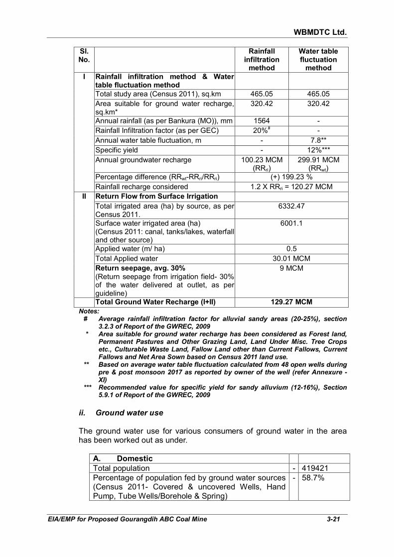
WBMDTC Ltd.
EIA/EMP for Proposed Gourangdih ABC Coal Mine 3-21
Sl. No.
Rainfall infiltration
method
Water table fluctuation
method
I Rainfall infiltration method & Water table fluctuation method
Total study area (Census 2011), sq.km 465.05 465.05 Area suitable for ground water recharge,
sq.km* 320.42 320.42
Annual rainfall (as per Bankura (MO)), mm 1564 - Rainfall Infiltration factor (as per GEC) 20%# - Annual water table fluctuation, m - 7.8** Specific yield - 12%*** Annual groundwater recharge 100.23 MCM
(RRri) 299.91 MCM
(RRwt) Percentage difference (RRwt-RRri/RRri) (+) 199.23 % Rainfall recharge considered 1.2 X RRri = 120.27 MCM
II Return Flow from Surface Irrigation Total irrigated area (ha) by source, as per
Census 2011. 6332.47
Surface water irrigated area (ha) (Census 2011: canal, tanks/lakes, waterfall and other source)
6001.1
Applied water (m/ ha) 0.5 Total Applied water 30.01 MCM Return seepage, avg. 30%
(Return seepage from irrigation field- 30% of the water delivered at outlet, as per guideline)
9 MCM
Total Ground Water Recharge (I+II) 129.27 MCM Notes:
# Average rainfall infiltration factor for alluvial sandy areas (20-25%), section 3.2.3 of Report of the GWREC, 2009
* Area suitable for ground water recharge has been considered as Forest land, Permanent Pastures and Other Grazing Land, Land Under Misc. Tree Crops etc., Culturable Waste Land, Fallow Land other than Current Fallows, Current Fallows and Net Area Sown based on Census 2011 land use.
** Based on average water table fluctuation calculated from 48 open wells during pre & post monsoon 2017 as reported by owner of the well (refer Annexure - XI)
*** Recommended value for specific yield for sandy alluvium (12-16%), Section 5.9.1 of Report of the GWREC, 2009
ii. Ground water use The ground water use for various consumers of ground water in the area
has been worked out as under.
A. Domestic
Total population - 419421 Percentage of population fed by ground water sources (Census 2011- Covered & uncovered Wells, Hand Pump, Tube Wells/Borehole & Spring)
- 58.7%

WBMDTC Ltd.
EIA/EMP for Proposed Gourangdih ABC Coal Mine 3-22
Total population dependent on Ground water as per Census 2011.
- 246200
Per capita domestic need. - 86 LPCD Total annual ground water use (365 days) - 7.7 MCM
B. Irrigation Total area irrigated by ground water (as per Census 2011- wells & tubewells)
- 331.41 ha
Gross irrigation (@0.5 m/ha/annum) - 0.5
Annual irrigation need (ha.m) 166 ha.m
Return seepage, avg. 30% - 50 ha.m
Annual consumption - 1.16 MCM
C. Livestock
Empirically considered as 5% of human consumption - 0.39 MCM
D. Industrial & Mine use
28 industries, Mines, cluster x average consumption 500 KLD per industry x 330 days
- 4.62 MCM
Total ground water withdrawal (A+B+C+D) - 13.87 MCM
iii. Ground water balance
Sl. No.
Particulars Million Cubic Meter (MCM)
i Estimated annual ground water recharge 129.27
ii. Estimate Annual draft 13.87
iii. Net annual ground water availability 115.4
iv. Stage of ground water development in % 10.73
3.7.3 Water quality
To evaluate the physico-chemical characteristics of the water resources
existing in the study area, water samples from surface and ground water sources were collected during the monitoring season and analyzed for physico-chemical parameters. Sampling locations are given in Table 3.11 and shown in Fig 3.8. Eight surface water samples and eight ground water samples were collected for assessing the water quality in study area. Apart from the surface and ground water samples, a drinking water sample has

WBMDTC Ltd.
EIA/EMP for Proposed Gourangdih ABC Coal Mine 3-23
also been collected from supply water, near Shani Temple, Panuriya village and analysed for physico-chemical parameters. The analysis results of water quality of the study area are presented in Annexure XII and range of main parameters of water analysis result is given in Table 3.11.
TABLE 3.11
WATER SAMPLING LOCATIONS
Sl. No.
Location of sampling station
Distance (km), Direction
Station Code Drinking water
sample Ground water
Surface water
1. Core Zone (Block A) Within core zone √
2. Core Zone (Block C) Within core zone √ √
3. Gourandih 0.35, between block A & C
√ √
4. Kantapahari 0.3, SE √
5. Kashidangal 0.2, N √ √
6. Baradang 0.9, S √
7. Daskiari 1.6, N √
8. Mirzapur 0.8, NNE √
9. Near Jitpur 2.6, NW √
10. Near Shyamapur 4.3, ENE √
11. Jamgram 0.8, SE √
12. Alipur 1.5, S √
13. Panuriya 0.1, N √ √
3.7.4 Methodology Samples from surface and ground water sources were collected by adopting
grab sampling. The samples were collected in polyethylene sampling bottles. In case of surface water, sample was collected from a point 12” below the surface.
The physico-chemical quality of water samples were characterized by
adopting the relevant parts of IS:3025, “Standard Methods for Water Analysis”, APHA 23rd Edition and the parameters prescribed in IS:10500:2012. For analysis, the samples were brought to Min Mec R&D Laboratory, New Delhi, after addition of applicable preservatives.
3.7.5 Observations
The analysis results of water quality of the study area are presented in
Annexure XII and the range of the parameters is given in Table 3.12.

WBMDTC Ltd.
EIA/EMP for Proposed Gourangdih ABC Coal Mine 3-24
TABLE 3.12 SUMMARY OF WATER QUALITY IN THE STUDY AREA
Parameters Limits (IS: 10500:2012 and Amendment No. 1)
Ground Water
Ranges
Surface water
Ranges
Drinking water
sample Desirable Permissible
Colour, Hazen units 5 15 <5 <5 <5 Odour Agreeable Agreeable Agreeable Agreeable Agreeable Turbidity, NTU 1 5 0.95-4.15 0.8-29.8 1.55 pH value 6.5 - 8.5 No relaxation 6.56-6.92 6.9-8.2 7.4 Specific conductance, µmhos
- - 267-1121 207-561 251
Total Dissolved Solids, mg/l
500 2000 176-718 136-368 154
Total Suspended Solids, mg/l
- - 4-30 6-54 10
Total Hardness as CaCO3, mg/l
200 600 44-257 32-158 95
Alkalinity, mg/l 200 600 84-420 46-181 97 Sulphate, mg/l 200 400 2-85 8-36 6 Chloride as Cl, mg/l 250 1000 14-135 23-78 25 Nitrate as NO3, mg/l 45 No relaxation 0.06-17.88 0.08-1.39 1.07 Dissolved oxygen, mg/l - - - 6.5-7.1 Calcium as Ca, mg/l 75 200 6-75 8-38 19 Biochemical Oxygen Demand (BOD), mg/l
- - - 5-30
Magnesium as Mg, mg/l 30 100 7-31 3-17 11 Iron as Fe, mg/l 1.0 No relaxation BDL-0.78 BDL-0.35 0.07 Fluoride as F, mg/l 1.0 1.5 0.41-1.1 0.28-0.58 0.39 Chemical Oxygen Demand (COD), mg/l
- - - 10-69
Silver as Ag, mg/l 0.1 No relaxation BDL-0.036 0.016-0.033 0.015 Barium as Ba, mg/l 0.7 No relaxation 0.043-0.525 0.016-0.105 0.034 Boron as B, mg/l 0.5 1 0.031-0.143 0.015-0.057 0.104 Chromium as Cr,mg/l 0.05 No relaxation BDL-0.023 BDL-0.013 BDL Copper as Cu, mg/l 0.05 1.5 BDL BDL BDL Lead as Pb, mg/l 0.01 No relaxation BDL BDL BDL Manganese as Mn, mg/l 0.1 0.3 0.017-0.255 BDL-0.097 BDL Nickel as Ni, mg/l 0.02 No relaxation BDL BDL BDL Selenium as Se, mg/l 0.01 No relaxation BDL BDL BDL Arsenic as As, mg/l 0.01 No relaxation BDL BDL BDL Zinc as Zn, mg/l 5 15 0.041-3.599 0.012-0.496 0.027 Total coliform (MPN/100ml)
- - - 10-47
E. Coli - - - Absent-Present
Residual chlorine, mg/l 0.2 1 - - NIL Source : MMRDL’s report no. MMW/02-2018/2, MMW/02-2018/3 and MMW/02-2018/1, dated
12-02-2018. Note : BDL (Below Detection Limit) of Pb<0.01, Fe<0.01, Ag<0.01, Cr<0.01, Cu<0.01,
Mn<0.01, Ni<0.01, Se<0.01, As<0.01, Cr6+
<0.1 mg/l
WBMDTC Ltd.
EIA/EMP for Proposed Gourangdih ABC Coal Mine 3-25
Almost all the parameters of water samples are well within the prescribed limits as per IS 10500: 2012 (Refer Annexure XIII). The analysis of the ground, surface and drinking (supply water) water samples shows:
Ground water:
� pH value varies between 6.56 to 6.92 in the ground samples which is
neutral and well within the desirable limit.
� In all the ground water samples, total hardness, turbidity, total dissolved solids, alkalinity, calcium, magnesium, fluoride and Manganese are well within the permissible limit and the concentration of nitrate, chloride, sulphate, silver, barium, zinc and iron are well within the desirable limit.
� Copper, lead, nickel, selenium and arsenic are below detectable limits for all the ground water samples.
� Since in ground water, all parameters were found to be within the desirable limits except total hardness, alkalinity and TDS, which were within permissible limits as per IS: 10500:2012, it makes it suitable for drinking in absence of any alternative source.
Surface water:
� pH value varies between 6.9 to 8.2 for all the surface water samples
which is neutral to moderate alkaline and well within the desirable limit.
� Turbidity is within the permissible limit only at two location i.e. in river near Jitpur village and Shyampur village and at other six location namely ponds in Panuriya, Kashidangal, Gourangdih, Core zone block-C and Baradang village, the turbidity is found beyond the permissible limit.
� In all the surface water samples, total hardness, total dissolved solids and alkalinity are well within the permissible limit and concentration of nitrate, chloride, sulphate, calcium, magnesium, fluoride, silver, boron, manganese, zinc and iron all are well within the desirable limit in all the surface water samples.
� Dissolved oxygen, Biochemical Oxygen Demand (BOD) and Chemical Oxygen Demand (COD) is found in the range of 6.5-7.1, 5-30 and 10-69 mg/l, respectively. While the total coliform is found in the range of 10-47 MPN/100ml and E. Coli is present only in the four samples locations namely ponds in Panuriya, Kashidangal, Gourangdih and Core zone block-C.
� Copper, lead, nickel, selenium and arsenic are found to be below detectable limits for all the surface water.
� In surface water, since all parameters were found to be within the desirable limits as per IS: 10500:2012 except turbidity in six samples,

WBMDTC Ltd.
EIA/EMP for Proposed Gourangdih ABC Coal Mine 3-26
it makes surface water suitable for drinking after treatment for turbidity.
Drinking (supply) water: � pH value is found 7.4 which is neutral and well within the desirable
limit. Total hardness, total dissolved solids, alkalinity, calcium, magnesium, nitrate, chloride, sulphate, zinc, barium, silver, boron, fluoride and iron are also found well within the desirable limit and the turbidity is well within the permissible limit.
� Chromium, copper, lead, nickel, selenium, arsenic and manganese are found below detectable limit while Residual Chlorine is nil.
� In supply water all parameters were found to be within the desirable limits and is potable.
3.8 SOIL QUALITY
Four soil samples were collected by using Auger from following locations:
Sl. No.
Name of Location Distance (km) and Direction
Type of Land
1 Core Zone (Block A) Within Agricultural 2 Core Zone (Block C) Within Agricultural 3 Gourangdih village 0.35/ between
block A & C Agricultural
4 Kantapahari village 0.3 / SE Agricultural
The samples are analysed for fertility as per standard methods. The test results of soil samples are given in Table 3.13.
TABLE 3.13
SOIL TEST RESULTS Parameters Unit Core Zone
(Block A) (S3)
Core Zone (Block C)
(S4)
Gourangdih (S1)
Kantapahari (S2)
Textural Classification
Medium grained sand
Medium grained sand
Medium grained sand
Medium grained sand
Grain size analysis
% retain
% finer
% retain
% finer
% retain
% finer
% retain
% finer
19 mm - 100 - 100 - 100 - 100 4.75 mm 6.55 93.45 19.14 80.86 4.7 95.3 6.02 93.98 2.0 mm 14.24 79.21 22.76 58.1 11.62 83.68 15.6 78.38 425 µm 57.04 22.17 38.49 19.61 70.53 13.15 62.43 15.95 75 µm 15.49 6.68 13.4 6.21 11.21 1.94 12.37 3.58 <75 µm 6.68 - 6.21 0 1.94 - 3.58 - Colour -- Yellowish Yellowish Yellowish Yellowish pH -- 5.90 7.30 7.20 6.80 E.C (mS/cm) 0.368 0.221 0.335 0.311 CaCO3 (%by mass) 2.5 7.5 3.5 8.0

WBMDTC Ltd.
EIA/EMP for Proposed Gourangdih ABC Coal Mine 3-27
Parameters Unit Core Zone (Block A)
(S3)
Core Zone (Block C)
(S4)
Gourangdih (S1)
Kantapahari (S2)
Moisture (% by mass) 5.69 12.06 22.12 13.75 Organic Carbon (% by mass) 0.52 0.34 0.16 0.52 Organic Matter (% by mass) 1.17 0.76 0.35 1.17 Chloride (% by mass) 0.02 0.03 0.03 0.03 Phosphorous (mg/kg) 0.17 0.09 0.07 0.02 Nitrate-Nitrogen (mg/kg) 56.67 43.33 10 6.67 Sodium (kg/ha) 94.08 136.64 235.2 178.08 Potassium (kg/ha) 94.0 53.0 112.0 370.0 Calcium2+ me/100g
Soil 1.37 2.45 4.70 2.74
Magnesium2+ me/100g Soil
0.49 0.88 0.69 0.59
Source: Report No. MMS/02-18/04, date 12/02/2018 of Min Mec R&D Laboratory, New Delhi
Particle size analysis shows that the texture of the soil is of medium grained
sand with yellowish colour. pH has been observed to be medium acidic at core zone (Block-A) to nearly neutral in range at three other locations. Electrical conductivity has been observed normal in range. Organic carbon, Nitrogen and Phosphorous have been found deficit in all the samples. Whereas, the potassium content in soil is low except at Kantapahari village.
3.9 ECOLOGY The current status of flora and fauna of the region have been recorded in
the subsequent paragraphs. 3.9.1 Forest
Total forest in the study area as per Census 2011 is 817.55 ha (1.76%).
Forest as classified by Champion and Seth is Tropical Dry Deciduous Forest Group 5B. The forests are scattered in different parts of the study area. Most of the forests remain leafless during dry season. As per SOI open series map, there are 13 protected forests (PF) present in study area. These can be seen in Fig 3.10 and list is given in Table 3.14.
TABLE 3.14
LIST OF FORESTS IN STUDY AREA
Sl. No. Description Distance, km Direction
1. PF Near Gaurangdih Within core zone 2. PF Near Narayanpur 0.6 NE 3. PF Near Kashidanga 0.8 E 4. PF Near Bankhet 5.6 NE 5. PF Near Chhota Rampur 5.9 ENE 6. PF Near Sarbediya 5.9 ENE 7. PF Near Petuashal 6 NNE 8. PF Near Harilpahari 6.5 NE

WBMDTC Ltd.
EIA/EMP for Proposed Gourangdih ABC Coal Mine 3-28
Sl. No. Description Distance, km Direction
9. PF Near Shialjori 6.5 NNE 10. PF Near Baraliya 8 ENE 11. PF Near Bagchhera 8.6 NE 12. PF Near Nimdangal 9.7 ENE 13. PF Near Pahargora 10 E
There are no National parks, Wildlife Sanctuary, Biospheres reserves and
migratory corridor of any schedule-1 species within 10 km radius. The nearest National Park is Simlipal at a distance of 228 km in SSW direction. The nearest wildlife sanctuary is Ramnabagon at a distance of 70 km in SE.
3.9.2 Flora Core zone: Out of total mining lease area, 109.459 Ha (30.7% of the project
area) is Forest Land (protected and jungle). Application for seeking Stage I Forest Clearance has been submitted vide Proposal No. FP/WB/MIN/26869/2017 dated 12.07.2017. The DGPS surveyed and geo referenced map of forest land use plan in Gourangdih ABC coal mine can be seen in Fig 3.11.
22 species of trees, 2 of shrubs & herbs and 2 of grasses and sedges are
present in the core zone. Common native species such as Neem, Jamun, Mango, Tad, Acacia etc. are present in the core area. Detailed list of flora in core zone is given in Annexure XIV.
Buffer zone: During the present survey, 45 plant species were recorded.
These included 39 tree species and 5 shrubs/herbs. Besides this two grass species are also present in the core and buffer zone together.
The plant species authenticated by Range forest officer, Asansol (T) Range
for both core zone and study area have been listed in Annexure XIV. Cropping pattern: The district has two principal cropping regions: Alluvial
on the Eastern Part and Laterite on the Western. On an average 58% of total population lives on agriculture. (http://bardhaman.nic.in/ collect/ admin _repo1213.pdf accessed on 10.05.2018)
Rice is the most important crop of the district and in the alluvial plains to the east little else is grown. The rice grown with its numerous varieties can broadly be grouped under the three primary classes distinguished from one another by distinct characteristics and they are - The Aus or autumn, the Aman or winter and the Boro or the summer rice. Paddy covers maximum of the gross cropped area. Among commercial crops Jute, Mesta and Sugarcane, potato, oil seeds are cultivated in marginal areas. (Source: http://bardhaman.nic.in/agri/agriculture.htm#food accessed on 10.08.2018).
Production and productivity of major crops in Bardhman District (Average of
5 years: 2004-08) has been given in Table 3.15.

WBMDTC Ltd.
EIA/EMP for Proposed Gourangdih ABC Coal Mine 3-29
TABLE 3.15 PRODUCTION AND PRODUCTIVITY OF MAJOR CROPS IN BARDHMAN
DISTRICT (AVERAGE OF 5 YEARS: 2004-08) Name of crop Kharif Rabi Summer Total
Production (‘000t)
Productivity (kg/ha)
Production (‘000t)
Productivity (kg/ha)
Production (‘000t)
Productivity (kg/ha)
Production (‘000t)
Productivity (kg/ha)
Major Field Crops
Rice 48.1 3069 1231.1 2953 642.5 3129 1921.7 3012 wheat - - 6.7 2313 - - 6.7 2313 Pulses - - 1.2 849 - - 1.2 849 Oilseeds - - 43.1 850 - - 43.1 850 Jute 223.0 3019 - - - - 223.0 3019 Potato - - 1058.0 21674 - - 1058.0 21674 Major horticulture crops
Cucurbits - - 126.0 9687 - - 126.0 9687 Brinjal - - 145.2 17767 - - 145.2 17767 Cabbage - - 92.7 28513 - - 92.7 28513 Cauliflower - - 85.9 27167 - - 85.9 27167 Okra - - 55.8 11330 - - 55.8 11330 Sowing windows for 5 major field crops (start and end of normal sowing period)
Rice Potato Oilseed Jute Vegetables
Kharif-Rainfed July 1st to 4th week
- - March 4th week to April 3rd week
Throughout the year
Kharif-irrigated - - - - - Rabi-Rainfed - - - - - Rabi Irrigated Jan 3rd to 4th
week Nov 1st to 2nd week
Nov 1st to 3rd week
- -
Source-Agriculture Contingency Plan for District Bardhaman-31.12.2011
Plantation on roads: It was observed that plantation of species on the roadside are Acacia catechu, Aegle marmelos, Madhuca longifolia, Azadirachta indica, Butea monosperma, Dalbergia sisoo, Ficus benghalensis, Ficus religiosa, Mangifera indica, Pisidium guava, Syzygium cumini, Tamarindus indica, Tectona Grandis, Terminalia tomentosa etc.
Vegetation in the Hamlets: The species composition near the hamlets is
different from those found in the natural environmental conditions. The vegetation structure surrounding the hamlets reflects a typical character of habitation. The trees in the settlement area are catering to the needs of local population such as fodder, fuel-wood, fruit, and timber and for religious purposes. Some of the common species found in the hamlets comprise Mangifera indica, Syzygium cumini, Madhuca indica, Terminalia arjuna etc.
Medicinal plant species: The study area is also endowed with several medicinal plants. Many medicinal plants are found in the study area which are used by the people of villages for their daily use and minor ailments. The common medicinal plants of the region are Azadirachta indica, Butea monosperma, Ficus benghalensis, Ficus racemosa, Ficus religiosa, Madhuca longifolia, Mangifera indica, Ocimum sanctum, Syzigium cuminii, Terminalia grandis, Terminalia arjuna, Zizyphus mauritiana etc.

WBMDTC Ltd.
EIA/EMP for Proposed Gourangdih ABC Coal Mine 3-30
FIG 3.10: FOREST MAP OF THE STUDY AREA BASED ON OPEN SERIES MAP
Z

WBMDTC Ltd.
EIA/EMP for Proposed Gourangdih ABC Coal Mine 3-31
Fuel wood plant species: Villagers collect dry leaves, stems and log to fulfill their daily need for fuel wood requirement. Syzygium cumini (Jamun), Mangifera indica (Mango) etc. are the species, used for fuel wood.
3.9.3 Fauna Core and Buffer zone were taken into consideration while preparing a list of
species of fauna. Core zone: Due to the presence of trees, shrubs, herbs and grasses in the
core zone, a variety of fauna is found. Common avifauna such as house sparrow, house crow, pigeon, common myna, owl, koel, bulbul and wood sandpiper were observed. Mammals such as hare, squirrel, common house rat, mongoose and Indian field mouse have been observed. Amongst reptiles, common garden lizard, chameleon and Indian cobra were seen or reported by villagers.
Buffer zone: During primary survey of study area and from secondary data
sources, total of 38 species of fauna have been estimated, comprising 12 species of mammals, 14 species of birds, 7 species of reptiles and 5 species of aquatic fauna (fishes).
The common species of fauna observed in the study area are Common
Langur, Common House Rat, Indian Hare, etc. The common bird species i.e. avifauna recorded during the survey in the study area are House Sparrow, Indian Mayna, Pigeon and Grey partridge etc. The list of fauna authenticated by Range forest officer, Asansol (T) Range for both core zone and study area is given in Annexure XV.
The project site surroundings does not support any habitat for any group of
wild animal except few animals such as monkey, squirrel and lizards species, which are well adapted to urban areas. They live in the agricultural field, open scrub land and near the river and nala side.
Animal Husbandry: Animal husbandry occupies an important place in the
rural economy of Burdhaman district. It provides them with the draught power required for cultivation and an additional means of supplementing their income. To the farmers, cattle are a valuable form of wealth.
The live-stock plays a vital role in the agricultural economy of the district,
because it not only supplies milk, meat, manure, bones, hides and skins, hoofs and horns but also serves as draught cattle for drawing carts, ploughs and is also used for drawing water. Live-stock products in the district comprise milk, eggs, skins and hides, wool, manures, etc.
As per the survey and reports, no endangered/Schedule I species or ecologically sensitive area/migratory corridor is present within a radius of 15 km of the proposed mine site.

WBMDTC Ltd.
EIA/EMP for Proposed Gourangdih ABC Coal Mine 3-32
3.10 TRAFFIC DENSITY 3.10.1 Monitoring location The traffic density survey was conducted both in up and down direction at
three locations namely Baradang (0.9 km from the proposed mine in S direction), Majandih (1.6 km from the proposed mine in NE direction) and Dharaspur (3.5 km from the proposed mine in WSW direction) on 03-04/01/2018, 07-08/01/2018 and 10-11/01/2018, respectively. The locations are shown in Fig 3.8.
3.10.2 Methodology
Traffic density was recorded continuously for 24 hours during the monitoring
days by visual observation and counting of vehicles under six categories, viz., heavy motor vehicles (buses & truck), light motor vehicles, cycles, motor cycles & scooters, animal drawn vehicles and others. As traffic density on the road is low, one skilled person was deployed during each shift. At the end of each hour, fresh counting and recording was undertaken. Thus, total numbers of vehicles per hour under each category was determined. The monitoring result is given in Annexure XVI.
The result of presence of slow moving vehicles in traffic stream is that it
affects the free flow of traffic. A way of accounting for the interaction of various kind of vehicles is to express the capacity of roads in terms of common unit. Therefore, the number of vehicles have been converted into “passenger car units” (PCUs) using the equivalency factor as per Table 1 of IRC: 64-1990 and the volume of traffic on the three routes are summarised in Table 3.16.
TABLE 3.16
TRAFFIC DENSITY Code T1 T2 T3
Location Baradang Majandih Dharaspur
Observed count
(up+down)
Equivalent PCU
Observed count
(up+down)
Equivalent PCU
Observed count
(up+down)
Equivalent PCU
Cycles ( E.F: 0.5) 857 429 1697 848.5 1350 675
Motor Cycles & Scooters (E.F: 0.5) 2606 1303 1716 858 1615 807.5
LMV (E.F: 1) 812 812 530 530 249 249
Buses (E.F: 3) 205 615 116 348 0 0
Trucks (E.F: 3) 557 1671 378 1134 71 213
Animal Drawn Vehicles (E.F: 8) 0 0 0 0 4 32
Others (E.F: 1.5) 218 327 151 226.5 175 262.5 Total 5255 5157 4588 3945 3464 2239
Width of Road 5.8 m 6.5 m 3 m
DSV*( Table 3, 4, 5 and section 10.3 as per IRC:64-1990) in PCU/DAY
6000 6000 2000
Maximum Capacity as per IRC 64-1990, section 6.1= DSV*0.5 % Utilisation
In PCU/day 12000 12000 4000
%Utilization 43.0 32.9 56.0
* DSV(Design Service Volume): it is defined as the maximum hourly volume (Vehicles per hour) at which vehicles can reasonably be expected to traverse a point or uniform section of a lane or roadway during a given time period under the prevailing roadway, traffic and control conditions while maintaining a designated level of service.

WBMDTC Ltd.
EIA/EMP for Proposed Gourangdih ABC Coal Mine 3-33
The condition of the road at Baradang and Majandih is good and it is well maintained. Whereas, the road near Dharaspur is having road width only 3 m, which needs widening and maintenance. From the perusal of Table 3.16, it is found that at Baradang, current utilisation is 43.0% of maximum capacity of the road, at Majandih the current utilization is 32.9% of maximum capacity of the road and at Dharaspur, the current utilization is 56.0% of maximum capacity of the road.
3.11 SEISMICITY The project is under moderate seismic zone (Zone-III). 3.12 LAND ENVIRONMENT 3.12.1 Land use in core zone Total project area is 356.575 ha. This includes applied ML area of 213.27 ha
and 143.305 ha outside of the ML. The break-up of the pre-mining land use is given in Table 3.17. The pre-mining land use can be seen in Fig 3.11 in the Land Ownership map.
TABLE 3.17
PRE-MINING LAND USE OF THE PROJECT AREA
Land pattern Total Area (Ha)
Within ML area (ha)
Outside ML area (ha)
Agricultural Land 48.43 48.43 22.670
Fallow land (Danga) 44.07 21.40
Degraded land (Old quarry area) 61.316 13.220 48.096
Built up area 60.86 26.140 34.720
Water body 15.44 7.640 7.800
Forest land (protected & jungle) 109.459 96.440 13.019
Non agricultural land for colony (outside core area)
5.00 - 5.000
Non agricultural land for Rehabilitation (outside core area)
12.00 - 12.000
Total 356.575 213.270 143.305
Source: WBMDTC Ltd.
Stage of land acquisition Out of 356.575 Ha of Project Land, 109.459 Ha is Forest Land, for which
application for diversion has been made. Out of 50 Ha identified Government Vested Land, request has been made to GoWB for perpetual transfer of 40 Ha. The Private Land will be procured from PAPs in consultation with District Magistrate, Paschim Bardhaman.

WBMDTC Ltd.
EIA/EMP for Proposed Gourangdih ABC Coal Mine 3-34
FIG 3.11: LAND OWNERSHIP MAP

WBMDTC Ltd.
EIA/EMP for Proposed Gourangdih ABC Coal Mine 3-35
3.12.2 Land use in buffer zone The land use pattern in the buffer zone of Gourangdih ABC coal mine as per
Census 2011 is given in Fig 3.12, summarized in Table 3.18 and detailed in Annexure XVII.
TABLE 3.18
LAND USE PATTERN IN STUDY AREA (AS PER CENSUS 2011)
Land use Area (Ha) %
Forest land 817.55 1.76
Area under non-agricultural use 14281.93 30.71
Barren and un-cultivable land 181.10 0.39
Permanent pastures and other grazing land 71.86 0.15
Land under Miscellaneous tree crops 168.11 0.36
Culturable waste land 3886.63 8.36
Fallow land other than current fallow 73.58 0.16
Current fallow 8.92 0.02
Net sown area 27015.77 58.09
Total 46505.45 100
A perusal of Fig 3.12 shows that the net shown area accounts for a major
portion (58.09%) followed by area under non-agricultural use (30.71%), culturable waste land (8.36%) and forest land (only 1.76%).
The latest land use of the study area can be seen in Fig 3.13, wherein the
latest satellite image has been extracted through Google Earth.
FIG 3.12:

WBMDTC Ltd.
EIA/EMP for Proposed Gourangdih ABC Coal Mine 3-36
FIG 3.13: SATELLITE IMAGERY OF 10 KM RADIUS

WBMDTC Ltd.
EIA/EMP for Proposed Gourangdih ABC Coal Mine 3-37
3.13 SOCIO-ECONOMIC CONDITIONS
The socio-economic conditions based on Census data, 2011 of the area are described in the following paragraphs.
3.13.1 Demographic details of core zone
As per approved revised mining plan, the proposed mine area comes under
three mouzas namely Panuriya, Gourangdih and Kantapahari covering seven villages. These villages are Shibdhara, Bandhaura, Lalbandh in Gourangdih-A and part of Panuriya, Kantapahari, Gourangdih & Bhuiapara in Gourangdih-C. The population of these villages will be affected by proposed coal mining.
As seen in Fig 3.11 i.e. the land use map, the project area lies in Panuriya (CT), Kantapahari and Jamgram. Panuriya (520.71 ha) is a census town with total population of 8399 (4236 Male & 4163 female). The Schedule Caste (SC) population is 2044 and Schedule Tribe (ST) 1076 only. Literacy rate of Panuriya is 73.13 %. which is lower than state average of 76.26 %. 31.50% of the population are dominated by workers. Agriculture activity is very less. Kantapahari (153.86 Ha) has 397 nos. of houses with around 1864 population (934 male & 903 female). In this village SC population is 499 and ST population 403 only. Kantapahari village has lower literacy rate compared to West Bengal. In 2011, literacy rate of Kantapahari village was 68.83 % compared to 76.26 % of West Bengal. In Kantapahari Male literacy rate was 82.57 % while female literacy rate was 54.49 %. Jamgram (1623.60 Ha) has 1523 nos. of houses with around 7614 population (3917 male & 3697 female). In this village SC population is 1819 and ST population 2423 only. Jamgram village has lower literacy rate compared to West Bengal. In 2011, literacy rate of Jamgram village was 51.24 % compared to 76.26 % of West Bengal. In Jamgram Male literacy rate was 61.27 % while female literacy rate was 40.62 %. Most of the houses in these villages are electrified with communication system and transport facilities available. A large number of work force come from adjoining Dumka district of Jharkhand. Education facilities comprises of lower, middle and higher secondary school at Panuriya. Post office facilities exist in Panuriya along with telephone and mobile tower.
3.13.2 Demographic details of buffer zone The village wise population is given in Annexure XVIII and the same is
summarized in Table 3.19. Distribution of population along with percentage of SC and ST population and, percentage of literates are presented through pie chart/diagram in Fig 3.14 and Fig 3.15.

WBMDTC Ltd.
EIA/EMP for Proposed Gourangdih ABC Coal Mine 3-38
TABLE 3.19 DISTRICT AND SUB-DISTRICT WISE POPULATION IN THE STUDY AREA
District Sub-District No. of villages
No. of households
Total population
Male Female
Paschim Bardhaman (West Bengal)
Salanpur 60 38488 181069 93313 87756
Barabani 51 25120 123598 63950 59648
Jamuria 9 3597 17886 9302 8584
Jamtara
(Jharkhand)
Jamtara 5 9850 48996 25703 23293
Nala 88 9810 47872 24306 23566
Total 213 86865 419421 216574 202847
Percentage 100% 51.64% 48.36%
The village wise additional demographic details including family size, sex
ratio, schedule caste, schedule tribe, literacy level, etc. are given in Annexure XVIII and summarised in Table 3.20.
TABLE 3.20
DEMOGRAPHIC DETAILS OF THE STUDY AREA (AS PER CENSUS 2011)
Description Population Percentage
Females/1000 males 936
Family size, persons/family 4-5
Schedule caste 99314 23.68
Schedule Tribe 55246 13.17
Total literates 274452 65.44
Male literates 158017 37.67
Female literates 116435 27.76
The percentage of Scheduled Tribes is 13.17% and Schedule Castes is
23.68% of the total population. There are 936 women against every 1000 men in the study area. The average family size is 4-5 persons per family. The literacy level is 65.44% and it is lower among females (27.76%) compared to males (37.68%).

WBMDTC Ltd.
EIA/EMP for Proposed Gourangdih ABC Coal Mine 3-39
3.13.3 Employment and occupation
Employment pattern and occupation are the two main indicators of the economic profile and the same for the individual villages, based on 2011 census data, are presented in Annexure XIX. A summary of employment pattern and occupation for the study area is presented in Table 3.21. While the employment pattern, breakup of main & marginal workers, breakup of main workers and breakup of marginal workers are also depicted in Fig 3.16, 3.17, 3.18 and 3.19, respectively.
FIG 3.14:
FIG 3.15:

WBMDTC Ltd.
EIA/EMP for Proposed Gourangdih ABC Coal Mine 3-40
TABLE 3.21 EMPLOYMENT PATTERN IN THE STUDY AREA
Occupation Population %
Main workers 94474 22.52
Marginal workers 42910 10.23
Non workers 282038 67.24
Total Population 419421 100.00
Break-up of main workers
Cultivators 8318 8.80
Agriculture labour 8922 9.44
Household industry 1924 2.04
Others 75309 79.71
Total 94474 100.00
Break up of marginal workers
Cultivators 5631 13.12
Agriculture labour 14318 33.37
Household Industries 1863 4.34
Other workers 21099 49.17
Total 42910 100.00
It can be seen from the above table that main worker and marginal workers
form 22.52% and 10.23% respectively of the total population. Other workers account for 79.71% of the main workers and 49.17% of the marginal workers. It should be noted that the agriculture and coal mining are the basic sectors of employment for the people of the leasehold and adjoining area. People are engaged in coal mines and coal based industries. There are many coal based and other industries in nearby areas like Kulti, Sitarampur, Barakar, Asansol, Chittaranjan which provide many employment opportunities for these people.

WBMDTC Ltd.
EIA/EMP for Proposed Gourangdih ABC Coal Mine 3-41
FIG 3.16: FIG 3.18:
FIG 3.17: FIG 3.19:

WBMDTC Ltd.
EIA/EMP for Proposed Gourangdih ABC Coal Mine 3-42
3.13.4 Displaces-Need Rehabilitation and Resettlement The proposed mine area comes under three mouzas namely Panuriya,
Gourangdih and Kantapahari covering seven villages. These villages are Shibdhara, Bandhaura, Lalbandh in Gourangdih-A and part of Panuriya, Kantapahari, Gourangdih & Bhuiapara in Gourangdih-C. The population of these villages will be affected by proposed coal mining. The habitation of these villages will be shifted for which separate R&R cost has been estimated.
As per current surveys (2017) done by M/s KMPG, 629 houses have been
identified for R&R. Besides dwelling units, various PAFs under different categories have also been identified for R&R. The details are given in Table 3.22.
TABLE 3.22
DWELLING UNITS & VARIOUS PAFS TO BE DISPLACED
Sl. No.
Description No. of PAFs/units
1 PAFs to be monetarily compensated for loss of dwelling unit
Categories Count
Kutcha authorised house within surveyed area of 213 ha
65
Kutcha unauthorised house within surveyed area of 213 Ha
183
Kutcha house outside surveyed area of 213 Ha
60
Pucca authorised house within surveyed area of 213 Ha
200
Pucca unauthorised house within surveyed area of 213 Ha
69
Pucca house outside surveyed area of 213 Ha
52
Total 629
629
2 PAFs to be monetarily compensated for loss of land (applicable for legal title holders only)
377
3 Number of PAFs belonging to either Scheduled Caste or Scheduled Tribe category
339
Note: 5% of the total PAFs fall under each of the five categories, namely, (i) petty shop owners, (ii) STs in possession of forest land and dependent on forest produce, (iii) sharecroppers/bargadars, (iv) landless agricultural labourers and (v) landless non-agricultural labourers.

WBMDTC Ltd.
EIA/EMP for Proposed Gourangdih ABC Coal Mine 3-43
3.13.5 Amenities Details of amenities available in individual villages are given in Annexure
XX. A summary of the same is given in Table 3.23.
TABLE 3.23 AMENITIES AVAILABLE IN VILLAGES AND TOWNS WITHIN THE
STUDY AREA (AS PER CENSUS 2011)
Education Villages 197 Pre-Primary School, 266 Primary school, 61 Middle school, 21 Secondary school, 9 Sr. Sec. School, 2 Deg. College Arts & Science only, 1 Engg. College, 1 Vocational Training School/ITI and 2 Others
Towns 79 Govt. Primary School, 19 Private Primary School, 14 Govt. Middle School, 3 Private Middle School, 13 Govt. Secondary School, 4 Private Secondary School, 14 Govt. Senior Secondary School, 3 Private Senior Secondary School, 3 Govt. Degree College-Art, Science and Commerce, 1 Govt.-Polytechnic and 1 Private-Shorthand, Typewriting, 1 Private-MS Office, 1 Private-Desk Top Publishing, 1 Govt.-Vocational(Others), 4 Govt.-Non Formal Education and 1 Govt.-Special School for Disabled
Medical and health care
Villages 2 Community Health Centres, 8 Primary Health Centre, 30 Primary Health Sub-Centre, 5 Maternity and Child Welfare Centre, 1 Hospital Allopathic, 14 Dispensary, 2 Veterinary Hospital, 6 Mobile Health Clinic, 5 Family Welfare Centre, 19 Non Govt. Med. facilities Out Patient, 7 Non Govt. Med. facilities in and Out Patient, 1 Non Govt. Med. facilities Charitable, 35 Non Govt. Med. facilities Medical Prctitioner with MBBS Degree, 76 Non Govt. Med. facilities Medical Prctitioner with other Degree, 27 Non Govt. Med. facilities Medical Practitioner with no Degree, 24 Non Govt. Med. facilities Traditional Practitioner and Faith Healer, 36 Non Govt. Med. facilities Medicine Shop and 7 Non Govt. Med. facilities Others
Towns 4 Hospital Allopathic, 9 Dispensary/Health Centre, 1 Family Welfare Centre, 70 Maternity Home Nearest facility Distance (in kms.), 2 T.B. Hospital/ Clinic, 3 Nursing Home, 136 Non-Government Out-Patient, 13 Non-Government In and Out Patient, 7 Non-Government Charitable-Hospital/Nursing Home and 61 Non-Government Medicine Shop
Power Supply
Villages 158 Power Supply For Domestic Use (nos.), 43 Power Supply ForAgriculture Use (nos.) and46 Power Supply For All Users (nos.)
Towns 24239 Electricity-Domestic Connection (nos.), 397 Electricity-Industrial Connection (nos.), 2202 Electricity-Commercial Connection (nos.), 3242 Electricity-Road Lighting Connection (nos.) and 13
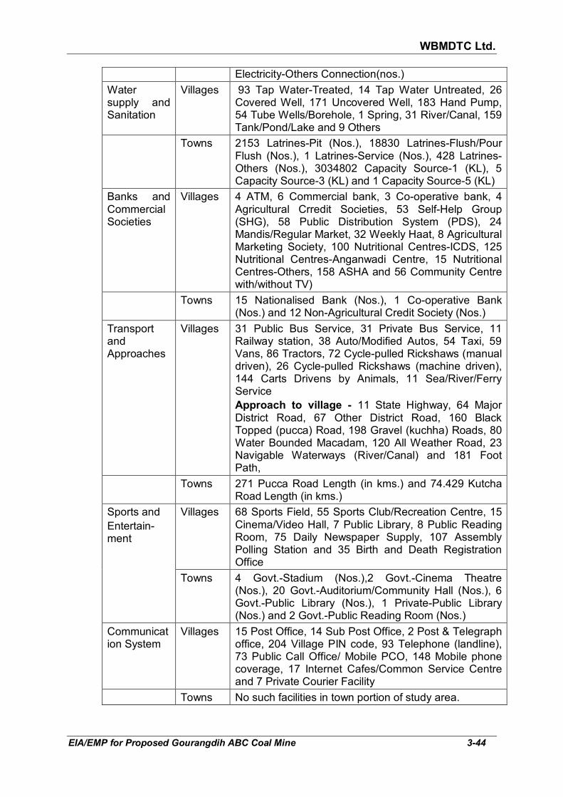
WBMDTC Ltd.
EIA/EMP for Proposed Gourangdih ABC Coal Mine 3-44
Electricity-Others Connection(nos.)
Water supply and Sanitation
Villages 93 Tap Water-Treated, 14 Tap Water Untreated, 26 Covered Well, 171 Uncovered Well, 183 Hand Pump, 54 Tube Wells/Borehole, 1 Spring, 31 River/Canal, 159 Tank/Pond/Lake and 9 Others
Towns 2153 Latrines-Pit (Nos.), 18830 Latrines-Flush/Pour Flush (Nos.), 1 Latrines-Service (Nos.), 428 Latrines-Others (Nos.), 3034802 Capacity Source-1 (KL), 5 Capacity Source-3 (KL) and 1 Capacity Source-5 (KL)
Banks and Commercial Societies
Villages 4 ATM, 6 Commercial bank, 3 Co-operative bank, 4 Agricultural Crredit Societies, 53 Self-Help Group (SHG), 58 Public Distribution System (PDS), 24 Mandis/Regular Market, 32 Weekly Haat, 8 Agricultural Marketing Society, 100 Nutritional Centres-ICDS, 125 Nutritional Centres-Anganwadi Centre, 15 Nutritional Centres-Others, 158 ASHA and 56 Community Centre with/without TV)
Towns 15 Nationalised Bank (Nos.), 1 Co-operative Bank (Nos.) and 12 Non-Agricultural Credit Society (Nos.)
Transport and Approaches
Villages 31 Public Bus Service, 31 Private Bus Service, 11 Railway station, 38 Auto/Modified Autos, 54 Taxi, 59 Vans, 86 Tractors, 72 Cycle-pulled Rickshaws (manual driven), 26 Cycle-pulled Rickshaws (machine driven), 144 Carts Drivens by Animals, 11 Sea/River/Ferry Service Approach to village - 11 State Highway, 64 Major District Road, 67 Other District Road, 160 Black Topped (pucca) Road, 198 Gravel (kuchha) Roads, 80 Water Bounded Macadam, 120 All Weather Road, 23 Navigable Waterways (River/Canal) and 181 Foot Path,
Towns 271 Pucca Road Length (in kms.) and 74.429 Kutcha Road Length (in kms.)
Sports and Entertain-ment
Villages 68 Sports Field, 55 Sports Club/Recreation Centre, 15 Cinema/Video Hall, 7 Public Library, 8 Public Reading Room, 75 Daily Newspaper Supply, 107 Assembly Polling Station and 35 Birth and Death Registration Office
Towns 4 Govt.-Stadium (Nos.),2 Govt.-Cinema Theatre (Nos.), 20 Govt.-Auditorium/Community Hall (Nos.), 6 Govt.-Public Library (Nos.), 1 Private-Public Library (Nos.) and 2 Govt.-Public Reading Room (Nos.)
Communication System
Villages 15 Post Office, 14 Sub Post Office, 2 Post & Telegraph office, 204 Village PIN code, 93 Telephone (landline), 73 Public Call Office/ Mobile PCO, 148 Mobile phone coverage, 17 Internet Cafes/Common Service Centre and 7 Private Courier Facility
Towns No such facilities in town portion of study area.

WBMDTC Ltd.
EIA/EMP for Proposed Gourangdih ABC Coal Mine 3-45
3.13.6 Health Issues
Diabetes, hypertension, fever and dysentery/ diarhoea are the common diseases prevalent in the project-impacted villages. There are many government and private hospitals available in the area. Panuriya and Gourangdih village has one Government hospital and 6 private clinic, where the people can have medical check-ups. Almost all facilities are available in these hospitals and private clinics. A base line data related to health status of the people of Barabani CD block has been obtained from Kelejora BPHC, Barabani CD block and is summarised below in Table 3.24.
TABLE 3.24
HEALTH ISSUES IN BARABANI CD BLOCK (YEAR 2017)
Health issues Number of affected person
Total Male Female
Injured Persons by type of Treatment received
Severe 10 9 1
Major 95 76 19
Minor 2375 1376 999
Acute illness
Diarrhoea/ Dysentery 444 263 181
Acute Respiratory Infection (ARI) 1497 765 732
Fever (All Types) 6041 2788 3253
Chronic illness
Diabetes 142 67 75
Hypertension 1037 556 481
Tuberculosis (TB) 144 100 44
Asthma / Chronic Respiratory Disease 70 51 19
Childhood diseases
Children suffering from Diarrhoea (%) 170 80 90
Children suffering from Diarrhoea who received HAF/ORS/ORT (%)
140 60 80
Children suffering from Acute Respiratory Infection (%)
430 205 225
Source: Kelejora BPHC, Barabani CD block
Barabani police station: Apart from the above, road traffic accident data of year 2017 within 10 km radius of Gourangdih ABC coal mine has also been collected from Barabani police station and it can be seen that total 5 cases of road accident were reported. Out of 5 cases, 3 cases were of fatal nature. Three people were killed and two were injured. Vehicle involved in accident was mainly two wheeler (bike) and Heavy vehicle.

WBMDTC Ltd.
EIA/EMP for Proposed Gourangdih ABC Coal Mine 3-46
3.14 INDUSTRIES AROUND THE MINING LEASE IN THE STUDY AREA Industries and mines in 10 km radius. The list of the industries and mines
located in the study area are listed below in Table 3.25 and the map showing industries is given in Fig 3.20.
TABLE 3.25
LIST OF MINES AND INDUSTRIES LOCATED WITHIN 10 KMS Industries/ Coal
Blocks Distance
(km), Direction
II. List of coal blocks
Distance (km),
Direction
I. Industries
I-1 Hindustan Cables Ltd. 6.7, W 11 Kanyapur 7.2, S I-2 Mega Mould India Ltd. 9.4, S 12 Barmondia
Sector-A 9.6, S
I-3 Chittranjan locomotive works
6.6, NW 13 Gopalpur 8.6, SSW
I-4 1X40 MW Thermal Power Plant at Sarishatali (Madanpur)
5.1, SE 14 Itapara 2.5, S
II. Coal Blocks 15 Itapara South 3.7, S 1 Gaurangdih-D Adjoining, E 16 Mohanpur 2.8, SW 2 Gaurangdih South Adjoining, S 17 Mohanpur
South 3.4, SW
3 Gaurangdih Extn. 2.1, ESE 18 Lalganj 4.4, SSW 4 Sarishatali 2.1, E 19 Sadhna 4.7, SW 5 Sarishatali South 2.3, SE 20 Sadhna South 5.3, SW 6 Kasta West 5, ENE 21 Central
Salanpur 7.2, WSW
7 Kasta Central 9.4, E 22 Central Salanpur South
7.5, SW
8 Tara 7.5, ESE 23 Chalbalpur Mahismura
8.0, SW
9 Churulia 7.5, SE 24 Bonjemehari 9.7, WSW 10 Bhanora West 7.4, S
It may be noted that from the project, the nearest critically polluted area are
Asansol (13 km, S), Nirsa (26 km, WSW) and Sindri industrial area (27 km, WSW). Asansol has been listed at serial no. 42 with CEPI score 72.20 and Nirsa & Sindri industrial area has been listed at serial no. 13 with CEPI score 78.63 of the critically polluted areas in the country vide MoEF’s Office Memorandum no. J-11013/5/2010-IA.II(I) dated 13.01.2010.
3.15 PLACES OF TOURIST/ RELIGIOUS/ HISTORICAL INTEREST/
NATIONAL PARK/ SANCTUARY
There are no places of tourist/ religious/ historical interest/ national park/
sanctuary or archaeological importance in study area. The nearest National Park is Simlipal at a distance of 228 km in SSW direction. The nearest wildlife sanctuary is Ramnabagon at a distance of 70 km in SE.

WBMDTC Ltd.
EIA/EMP for Proposed Gourangdih ABC Coal Mine 3-47
FIG 3.20: LOCATION OF INDUSTRIES

WBMDTC Ltd.
EIA/EMP for Proposed Gourangdih ABC Coal Mine 4-1
CHAPTER 4
ANTICIPATED ENVIRONMENTAL IMPACT AND MITIGATION MEASURES
4.1 GENERAL The environmental baseline scenario as detailed in Chapter 3 and the
proposed mining and its associated activities as described in Chapter 2, are used to assess the likely impact and its extent on various environmental parameters in this chapter. The parameters, which are relevant within the context and are likely to be affected, are as listed below:
� Topography and drainage � Solid Waste
� Climatic conditions � Noise levels and ground vibration
� Air quality � Traffic
� Water resources � Ecology
� Water quality � Socio-economic
� Land use � Occupational Health and Safety
The Environmental Management Plan has been developed with a view to
minimize adverse impacts. In each of the areas of impact, measures have to be taken to mitigate adverse impacts and where these are beneficial in nature such impacts are to be enhanced/ augmented so that the overall adverse impacts are reduced to as low a level as possible.
4.2 TOPOGRAPHY AND DRAINAGE
4.2.1 Impact and management on topography
Core zone: The elevation as per approved Revised Mining Plan varies
between 135-174 m a.m.s.l. and old quarries are present in western portion (Khoirabad quarry) and eastern portion (Debu quarry) of the project. The initial impact on topography will be felt through (a) external dumping, (b) excavation of mine pit and (c) backfilling of old quarries. These three are discussed as follows:
� Out of the total project area of 356.575 ha, there will be three temporary
external dumps over 62.97 ha. The maximum height of the OB dumps will be 85 m above the ground level.
� At the end of life of mine, 213.27 ha of land shall be excavated by
opencast mining. Rest of the area will be partly used for ancillary activity of mining, colonies and ecological development of the area.
� When the mining will commence in Gourangdih A, the initial OB will be
dumped over the already de-coaled area of Khoirabad Colliery. A review

WBMDTC Ltd.
EIA/EMP for Proposed Gourangdih ABC Coal Mine 4-2
of the stage plans provided with the Approved Revised Mining Plan, April 2011 also shows that the Debu quarry will get filled with overburden during the course of mining.
Thus, topography will start getting impacted from the beginning of mining. Various areas within the project will be disturbed for excavation (213.27 ha), external dump (62.97 ha), top soil dump (13.73 ha), infrastructure including colonies (27.23 ha) and roads (8 ha). Only 31.37 ha shall remain under plantation on green belt & undisturbed area. The management of impact will be a continuous process, ending only in the post mine closure stage. The significant measures will be as follows: � The external overburden dumps over 62.97 has shall be rehandled and
backfilled after the end of mining operation i.e. during final mine closure period.
� Of the excavated 213.27 ha, at the end of mining operation i.e. after 27 years, 132.5 ha would have been internally backfilled and reclaimed. Thus, 80.77 ha would remain as mine void of depth 120 m in Block-A and 210 m in Block-C quarry, respectively. In the subsequent stage i.e. post mine closure stage, even these mine voids will be backfilled by the external overburden dumps rehandled from 62.97 ha, as mentioned above, bringing the level of the quarry nearly level to the surrounding ground level. The backfill will be reclaimed through agro-forestry and agriculture. Post mine closure stage plan showing this can be seen in Fig 4.8. The detailed process of the overburden handling during the course of the mine has been given in section 4.7.2 later.
Therefore, the topography will undergo changes throughout the life of mine only to be restored back to ground level after closure of the mine through above measures.
Buffer zone: The mining activity will not affect the topography outside of the
project area, all the activities will be carried out within the project area. 4.2.2 Impact and management on drainage Core Zone: The drainage has been discussed in section 3.2.2 of Chapter 3
earlier. A study of the drainage through the core zone in Survey of India Open Series Map indicates the following:
� The first order streams ultimately joining Ajay River will be disturbed
due to excavation and dumping. The total length of three first order streams getting affected will be 1.43 km (near Bhatar Colony 460 m and near Shivdhaura 970 m).
� One first order stream joining Noniya Jhore nala will get disturbed on south side of Quarry C, the length of which will be 300 m.

WBMDTC Ltd.
EIA/EMP for Proposed Gourangdih ABC Coal Mine 4-3
Therefore, a total of 1.73 km length of first order streams originating from project area will get affected due to excavation and external overburden dumps. As these are origin points of first order streams, no nala diversions are envisaged.
Rainwater run off will be managed by construction of garland drains around
the mine pit, along roads and OB dumps areas. The rainwater will be conveyed to the settling pond for settlement of suspended solids. Water collected in settling pond will be reutilised and excess will be released into the nearby natural nala. The rainwater falling directly into the mine pit will be collected in sumps to keep the working benches dry. Sump water will be pumped to the surface reservoir, suspended solids settled and reused. Hence, there will not be any adverse impact on the drainage system.
Buffer zone: The mining activity will not affect the drainage system outside of the project area as the total activities will be done within the project area.
4.3 CLIMATE
4.3.1 Impact on climate
The climatic conditions including temperature variations, wind direction and
speed, rainfall and humidity are governed by regional factors and the monsoons. As such, mining and other allied activities will not tend to influence the climate.
During the construction and development phase, the activities will be restricted to construction of roads, buildings, plants and machinery, layouts of stock piles and dumps, fuel storages, etc. Thus, no effect on climate and meteorology of area is expected due to the construction activities. However, carbon dioxide (green house gas) contributing fossil fuel in the form of diesel will be used to operate DG sets, trucks, dumpers and other heavy earth moving machinery, which will be a necessity. Hence, although no effect on meteorology of area is anticipated due to operation activities, there will be contribution in global warming due to carbon dioxide emissions. Hence, mitigation measures to minimise carbon dioxide will have to be taken.
4.3.2 Mitigation measures The operations are to be carried out in a limited area on the surface. As a
result no large scale climatological impacts are anticipated. Development of greenbelt, afforestation and rehabilitation work in the project area will contribute in a positive manner towards mitigation of greenhouse gases. Global warming is a global concern and hence, the company will be undertaking all possible measures to minimize the CO2 emissions. These include regular maintenance of all fossil fuel based machinery and equipment and ensuring their emissions remain within limits at all times.

WBMDTC Ltd.
EIA/EMP for Proposed Gourangdih ABC Coal Mine 4-4
4.4 AIR ENVIRONMENT Any surface mining, including opencast coal mining has always been a
dusty business. Sources of particulate matter in open cast mine is due to excavation, transportation, handling, loading and hauling operation. Dust generation due to mining operation occurs within the mine pit, from over haul roads as well as dumping areas. At the same time, gaseous pollutants like hydrocarbons, NO2, CO, CO2, SO2, etc. are also generated from the vehicle exhaust, due to blasting and spontaneous heating in coal stock.
Operations that will cause increase in pollution load in air within the area
are:
� Operation of diesel based equipment and vehicles.
� Removal of vegetation and soil from excavation, infrastructure and dumping areas.
� Handling of mineral and waste material.
� Transportation of mineral & waste material
� Dumping activities
� Drilling and blasting
� Sulphur dioxide and oxides of nitrogen will be generated due to exhaust from fossil fuel based machines and vehicles as well as due to blasting.
The specific issues pertaining to various mining activities are as follows:
1) Material handling by heavy equipment as well as coal handling plant
will release large amounts of dust if no action is taken for suppressing it at source, while the immediate effects will be poor visibility but intake of dust through inhalation and oral route can have health impacts at the secondary stage.
2) Blasting operation will result in the generation of dust and fumes.
There will be generation of fly rocks, which can be controlled by management measures. Blasting operations will generate noise and cause ground vibrations. However, the noise duration will last for few moments, hence, will not pose problem in case blasting is conducted during day time when back ground noise levels are higher than night. The ground vibrations are anticipated to cause negative impact if the charge per delay is not rationalised.
� Transport vehicles will generate dust and gaseous emission while
plying on haul roads. The loading and dumper transport operations are anticipated to add to air pollution in core zone if appropriate control measures like spraying of water are not adopted.
� Crusher/CHP will experience dust generation at loading hopper,
crushing and screening plant as the coal would be drier at these points.

WBMDTC Ltd.
EIA/EMP for Proposed Gourangdih ABC Coal Mine 4-5
4.4.1 Impact on air environment For estimating the increase in the air pollutants, air quality prediction
modelling has been carried out in three parts as follows:
(i) Due to mining, OB handling and internal haul roads within project area, for which FDM model has been used.
(ii) Due to transportation of coal through roads in study area, for which CAL3QHCR model has been used.
(iii) Due to DG sets, for which ISCST model has been used. The DG sets will operate in the scenario of power failure only.
The above are discussed in subsequent paragraphs: (i) Fugitive Dust Model One of the sources of air pollution will be fugitive dust. The quantification of
the impact of dust has been done through Fugitive Dust Model.
Fugitive Dust Model (FDM) is a computerized air quality model specifically designed for computing concentration and deposition impacts from fugitive dust sources. The sources may be point, line or area sources. FDM is generally based on the well-known Gaussian Plume formulation for computing concentrations, but the model has been specifically adapted to incorporate an improved gradient-transfer deposition algorithm. Emissions for each source are apportioned by the user into a series of particle size classes. A gravitational settling velocity and a deposition velocity are calculated by FDM for each class. Concentration and deposition are computed at all user selectable receptor location.
Modeling Procedure: Prediction of ground level concentrations (GLC’s)
due to proposed opencast mine has been done by FDM. The model uses rural dispersion and regulatory default options as per guidelines on air quality models. The model assumes receptors on flat terrain.
Model Input Data: For the modeling purpose, the total fugitive particulate
matter (suspended particulate matter i.e. SPM) has been estimated and PM10 and PM2.5 have been proportioned with respect to it. SO2 and NO2 from blasting and machinery operation have also been modelled. This modelling has been done for the maximum possible excavation and material handling in any given year as follows;
� 1.0 MTPA coal + 2.7 Mcum OB from Pit A over 52.005 Ha and � 1.5 MTPA coal + 4.55 Mcum OB from Pit C over 35.426 Ha.
Annually 330 working days with 8 hourly three shifts has been considered as per approved Revised Mining Plan, April 2011. The assumptions, input data and other details are given in Annexure XXI along with GLC isopleth

WBMDTC Ltd.
EIA/EMP for Proposed Gourangdih ABC Coal Mine 4-6
maps and the results are summarized in Table 4.1 for PM10, PM2.5, SO2 and NO2.
TABLE 4.1
PREDICTED INCREMENTAL GROUND LEVEL CONCENTRATION BY FUGITIVE DUST MODEL (µg/m3)
Rank Receptor Co-ordinates PM10 PM2.5 Distance from Project
boundary
X Y GLC GLC in m
1 288 13387.7 10298.3 25.9809 14.9390 100
2 289 13205.9 10292.0 23.5348 13.5325 100
3 319 13504.9 9823.3 22.3749 12.8656 500
4 318 14265.9 10055.0 22.3153 12.8313 500
5 347 15110.0 10788.0 22.1235 12.7210 1000
6 286 14236.0 10571.8 21.9548 12.6240 100
7 351 13985.0 9421.0 21.3555 12.2795 1000
8 281 14130.7 10431.4 19.2120 11.0469 100
9 290 13036.9 10185.0 17.1324 9.8512 100
10 350 14455.0 9592.0 16.3432 9.3974 100
Rank Receptor Co-ordinates SO2 NO2 Distance, m
1 318 14265.9 10055.0 60.2212 61.0121 500
2 347 15110.0 10788.0 56.4123 58.0809 1000
3 351 13985.0 9421.0 56.3964 57.4296 1000
4 319 13504.9 9823.3 54.1757 56.3167 500
5 286 14236.0 10571.8 49.3606 52.2632 100
6 287 14130.7 10431.4 48.2190 51.8235 100
7 288 13387.7 10298.3 45.6800 48.9304 100
8 289 13205.9 10292.0 44.2468 47.5291 100
9 350 14455.0 9592.0 44.0650 44.6525 100
10 352 13499.0 9323.0 41.1180 42.0998 1000
A perusal of above table shows that the maximum incremental values of
25.98 µg/m3 for PM10, 14.93 µg/m3 PM2.5, 60.22 µg/m3 SO2 and 61.01 µg/m3
NO2, respectively are anticipated at a distance of 100 to 500 m from the mining lease boundary.
The existing air quality values along with the anticipated incremental GLC
values at the air quality monitoring stations is given in Table 4.2.

WBMDTC Ltd.
EIA/EMP for Proposed Gourangdih ABC Coal Mine 4-7
TABLE 4.2 ANTICIPATED INCREMENTAL GLC VALUES AT THE AIR QUALITY
MONITORING STATIONS (µg/m3)
Pollutant Sampling Station
Maximum observed
value
Incremental Total NAAQS Standards
2009
Gaurangdih 74.2 11.117 85.317
Kantapahari 61.5 12.934 74.434
PM10 Kashidanga 78 9.939 87.939 100
Kashidangal 59.8 3.880 63.680
Baradang 69.7 4.484 74.184
Aliganja 63.9 1.551 65.451
Gaurangdih 42.9 6.392 49.292
Kantapahari 36.4 7.437 43.837
PM2.5 Kashidanga 45.3 5.715 51.015 60
Kashidangal 35.6 2.231 37.831
Baradang 39.8 2.578 42.378
Aliganja 36.7 0.892 37.592
Gaurangdih 11.1 27.762 38.862
Kantapahari 9 32.424 41.424
SO2 Kashidanga 12.1 23.528 35.628 80
Kashidangal 7.9 9.349 17.249
Baradang 10.6 11.235 21.835
Aliganja 7.9 3.702 11.602
Gaurangdih 13 30.344 43.344
Kantapahari 15.8 33.547 49.347
NO2 Kashidanga 16.7 24.611 41.311 80
Kashidangal 10.8 10.061 20.861
Baradang 15 12.059 27.059
Aliganja 10.9 4.101 15.001
It can be seen from Table 4.2 that after addition of the incremental GLC’s to
the existing air quality, the concentration of pollutants would increase, but still they would remain within the prescribed standards at all the sampling stations as per applicable standards.
(ii) Impact due to transportation
There in only one outgoing material, which is coal. Coal from the opencast faces will be loaded by 3.2 m3 diesel hydraulic shovel and 2.5 m3 diesel hydraulic backhoe onto 60 T coal body rear dumpers for hauling it to the

WBMDTC Ltd.
EIA/EMP for Proposed Gourangdih ABC Coal Mine 4-8
CHP and will be transported after sizing to various consumers through 25 T capacity trucks. Total material to be transported is estimated to be around 7576 TPD (assuming total working days as 330 and production 2.5 MT of coal in a year). There will be movement of maximum 608 trucks per day to and fro to railway siding or directly to consumers as follows: � By road - Since the end users will be various industries across the
different states, hence the direction of movement of trucks cannot be exactly identified but has been assumed to be predominantly towards Asansol on Gourangdih-Asansol road. A quantity of 1.0 MTPA is expected to be transported through this route.
� By road-rail combination - Additionally, four railway sidings namely, Bonjemehari, Barabani, Charanpur and Chinchuria railway siding have been selected for coal transportation. Out of these, any one is envisaged to be used for coal transportation through railway. Therefore, transportation till railway siding will also be through road. A quantity of 1.5 MTPA is expected to be transported to any of the above mentioned railway sidings.
The proposed railway sidings with connecting roads and Asansol-Gourangdih road can be seen in Fig 4.3.
The emissions due to the movement of dumpers for mineral & OB handling,
on the internal haul roads have been accounted in the previous section i.e. as part of the mining activities. However, the impact on ground level concentrations (GLCs) due to emission from truck movement outside project area for coal transportation has been modelled separately using CAL3QHC model, inputs & outputs of of which are given in Annexure XXII. Air quality prediction modelling has been carried out for worst case scenario i.e. assuming 100% load (1.5 MTPA) on all roads to all the proposed sidings. Other than the coal transportation, vehicles will be used for transport of manpower. In contrast to the larger trucks for coal carrying, these will have lower impact and over short distance (on route from colony to mine). Therefore, they have not been considered in modelling.
CAL3QHCR has been created by enhancing the basic algorithms of CAL3QHC to: 1) allow the capability to process a year of hourly meteorological, Carbon Monoxide (CO) or Particulate Matter (PM) emissions, traffic, and signalization data, 2) incorporate the complete ISCST2 mixing height algorithm, 3) allow the capability to vary traffic related input variables by hour of the week, and 4) incorporate various concentration averaging algorithms. CAL3QHC is a CALINE3 based model while CALINE3 is a steady-state Gaussian dispersion model designed to determine air pollution concentrations at receptor locations downwind of highways located in relatively uncomplicated terrain.
The maximum anticipated GLC around road due to transportation as
calculated by CAL3QHCR for PM10, PM2.5, SO2 and NO2 has been summarized in Table 4.3.
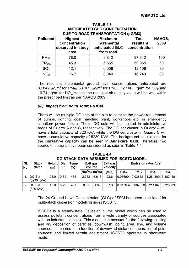
WBMDTC Ltd.
EIA/EMP for Proposed Gourangdih ABC Coal Mine 4-9
TABLE 4.3 ANTICIPATED GLC CONCENTRATION
DUE TO ROAD TRANSPORTATION (µµµµG/M3)
Pollutant Highest concentration
observed in study area
Maximum Incremental
anticipated GLC from road
Total resultant
concentration
NAAQS, 2009
PM10 78.0 9.842 87.842 100
PM2.5 45.3 5.665 50.965 60
SO2 12.1 0.006 12.106 80
NO2 16.7 0.040 16.740 80
The resultant incremental ground level concentrations anticipated are
87.842 µg/m3 for PM10, 50.965 µg/m3 for PM2.5, 12.106 g/m3 for SO2 and
16.74 µg/m3 for NO2. Hence, the resultant air quality value will be well within the prescribed limit as per NAAQS 2009.
(iii) Impact from point source (DGs) There will be multiple DG sets at the site to cater to the power requirement
of pumps, lighting, coal handling plant, workshops etc. in emergency situation/ power failure. These DG sets will be located in administrative areas of Quarry A and C, respectively. The DG set cluster in Quarry A will have a total capacity of 820 KVA while the DG set cluster in Quarry C will have a cumulative capacity of 5230 KVA. The background calculations for the cumulative capacity can be seen in Annexure XXIII. Therefore, two source emissions have been considered as seen in Table 4.4.
TABLE 4.4
DG STACK DATA ASSUMED FOR ISCST3 MODEL Sl.
No.
Stack Name
Height
(m)
Dia
(m)
Temp
(°C)
Exit gas Volume
Exit gas Velocity
Emission rates (g/s)
(Nm3/s) (m
3/s) (m/s) PM10 PM2.5 SO2 NO2
1. DG Set (5230 KVA)
23.0 0.61 485 2.382 6.613 22.6 0.066994 0.038521 1.284500 3.382440
2. DG Set (820 KVA)
13.0 0.25 497 0.67 1.89 37.3 0.013667 0.007858 0.211167 0.728889
The 24 Ground Level Concentration (GLC) of SPM has been calculated for multi-stack dispersion modelling using ISCST3. ISCST3 is a steady-state Gaussian plume model which can be used to assess pollutant concentrations from a wide variety of sources associated with an industrial complex. This model can account for the following: settling and dry deposition of particles; downwash; point, area, line, and volume sources; plume rise as a function of downwind distance; separation of point sources; and limited terrain adjustment. ISCST3 operates in short-term mode.

WBMDTC Ltd.
EIA/EMP for Proposed Gourangdih ABC Coal Mine 4-10
The 24 hrs average Ground Level Concentration has been calculated for PM10, PM2.5, SO2 and NO2 based upon meteorological data monitored and given in Annexure XXIII. The maximum anticipated 24 hours average GLC are summarised in Table 4.5.
TABLE 4.5
CALCULATED MAXIMUM GROUND LEVEL CONCENTRATION (µg/m3) FROM DG SETS
Parameter GLC Distance from stack
Direction from stack
PM10 0.13538 500 S
PM2.5 0.07784 500 S
SO2 2.59093 500 S
NO2 6.83864 500 S
(iv) Predicted cumulative incremental concentration Increase in ground level concentrations in ambient air due to mine activities,
transportation of coal and operation of DG sets have been summarized and compared with the national standards after adding to baseline in Table 4.6.
TABLE 4.6
GROUND LEVEL CONCENTRATIONS AFTER INCREMENT DUE TO MINING
ACTIVITIES, TRANSPORTATION AND DG SET OPERATION (µµµµg/m3)
Pollutant Maximum baseline value observed on any AAQ station
Increment due to mine
& its activities at AAQ station
Maximum Increment anticipated due to
transportation
Maximum Increment anticipated due to DG
set
Total resultant
concentration
Permissible Limits
(NAAQS 2009)
PM10 78.0 9.939 9.842 0.135 97.916 100
PM2.5 45.3 5.715 5.665 0.078 56.758 60
SO2 12.1 23.528 0.006 2.591 38.225 80
NO2 16.7 24.611 0.040 6.839 48.190 80
The above table shows that the emission from the mine, coal transportation
by road and DG set will increase pollution in the ambient air but it will remain below the National Ambient Air Quality Standard prescribed by NAAQS 2009 at any of the monitored ambient air quality stations.
4.4.2 Air pollution control measures Dust particles which are normally generated due to mining operation and
transportation deteriorate the ambient air quality. Control measures are, therefore, proposed to be taken during mining operation, loading and transportation. The processes in the project, the potential sources of emission along with control measures have been given in Table 4.7.

WBMDTC Ltd.
EIA/EMP for Proposed Gourangdih ABC Coal Mine 4-11
TABLE 4.7 FLOW-CHART INDICATING THE SPECIFIC AREAS GENERATING FUGITIVE EMISSIONS AND CONTROL
MEASURES THROUGHOUT THE MINE
Sl. No.
Activities & Flow Impact Mitigation & Management Measures
1
Drilling & Blasting ↓
� Dust generation during drilling � Fly rock and fugitive dust during
blasting
� Dust generation mitigated by wet drilling. � Fly rock and dust emission will be reduced by
adopting control blasting techniques such as precise and accurate timing delay, optimum oxygen balance in explosives, etc.
� Dust generation will be mitigated by water spraying before and after blasting.
2
� Excavation of coal and OB
↓ � Internal movement
of HEMM and vehicles within project boundary
↓ � Transportation of
coal and OB from quarry to CHP and OB dump, respectively
↓ � Unloading at CHP
and dumping of OB, respectively
↓
PM10, PM2.5, SO2, NO2 Emission due to
� operation of excavators & loaders, � loading of dumpers (fugitive dust) � movement of dumpers on haul roads
(dust & gases) � dumping (dust) � operation of other fossil fuel based
equipment/ machinery
� Maintenance of HEMM, transport vehicles like dumpers/ tippers and all other vehicles
� Wetting of the coal/ OB prior to loading � Dust suppression system like water sprinkling at
o working faces, o haul roads, o dumps o loading and unloading points o Coal stack yard o Transportation roads to minimize fugitive dust.
� Automatic water sprinkler system will be installed at main haulage road and where SPM are likely to be high constantly to suppress fugitive dust.
� Water sprinkling on other portions of the haul road within mine (where automatic spinklers not installed), two to four times a day according to season.
� Overloading of dumpers will not be permitted � Plantation in peripheral greenbelt (7.5m), in safety
zone between village and quarry (45 m) along the

WBMDTC Ltd.
EIA/EMP for Proposed Gourangdih ABC Coal Mine 4-12
Sl. No.
Activities & Flow Impact Mitigation & Management Measures
sides of haul roads (outside quarry area or working dumps) and other vacant areas.
� Reclamation of dump & backfill with plantation, agroforestry and agriculture
� Dust mask will be provided to the workers, engaged at dust generating sources such as excavation, loading etc.
3
Coal Handling plant with crusher
↓
Dust generation due to: Coal unloading → Crushing → Screening → Storage in stock pile and then loading or direct loading
� Dry fog system/ water sprinkling/ mechanical dust extraction system with bag filters at unloading point (receiving hopper), sieves, screens and loading points at CHP.
� Use of internal conveyors in CHP with wet dust suppression system at transfer points
� CHP installation in closed building � Green belt around CHP
4 Transportation of coal from stock yard to various consumers
Fugitive dust emission due to movement on roads and pm, so2 and no2 from exhaust of dumpers
� Production and delivery planning would be such that the minimum coal stock will present in the stock yards.
� The dumped coal will be compacted by HEMM so that minimum air is allowed to stay in the coal dump for protection from spontaneous combustion.
� Stock yards will be sprayed with water regularly. � Dust suppression system at truck/tippers loading
point. � Overloading not permitted � Spillage not permitted � The trucks shall be covered with tarpaulin. � PUC check for all vehicles mandatory � Use of pucca roads outside mining lease � Maintenance of road by state government.
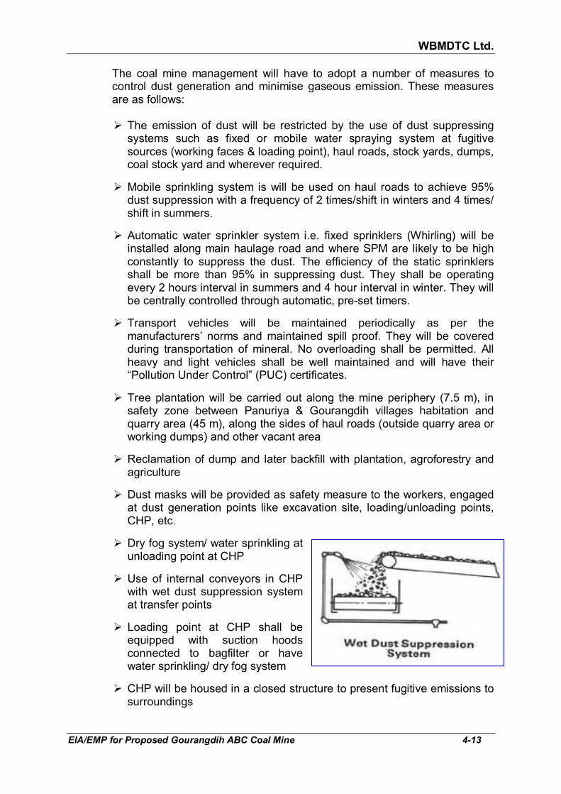
WBMDTC Ltd.
EIA/EMP for Proposed Gourangdih ABC Coal Mine 4-13
The coal mine management will have to adopt a number of measures to control dust generation and minimise gaseous emission. These measures are as follows:
� The emission of dust will be restricted by the use of dust suppressing
systems such as fixed or mobile water spraying system at fugitive sources (working faces & loading point), haul roads, stock yards, dumps, coal stock yard and wherever required.
� Mobile sprinkling system is will be used on haul roads to achieve 95% dust suppression with a frequency of 2 times/shift in winters and 4 times/ shift in summers.
� Automatic water sprinkler system i.e. fixed sprinklers (Whirling) will be installed along main haulage road and where SPM are likely to be high constantly to suppress the dust. The efficiency of the static sprinklers shall be more than 95% in suppressing dust. They shall be operating every 2 hours interval in summers and 4 hour interval in winter. They will be centrally controlled through automatic, pre-set timers.
� Transport vehicles will be maintained periodically as per the manufacturers’ norms and maintained spill proof. They will be covered during transportation of mineral. No overloading shall be permitted. All heavy and light vehicles shall be well maintained and will have their “Pollution Under Control” (PUC) certificates.
� Tree plantation will be carried out along the mine periphery (7.5 m), in safety zone between Panuriya & Gourangdih villages habitation and quarry area (45 m), along the sides of haul roads (outside quarry area or working dumps) and other vacant area
� Reclamation of dump and later backfill with plantation, agroforestry and agriculture
� Dust masks will be provided as safety measure to the workers, engaged at dust generation points like excavation site, loading/unloading points, CHP, etc.
� Dry fog system/ water sprinkling at unloading point at CHP
� Use of internal conveyors in CHP with wet dust suppression system at transfer points
� Loading point at CHP shall be equipped with suction hoods connected to bagfilter or have water sprinkling/ dry fog system
� CHP will be housed in a closed structure to present fugitive emissions to surroundings

WBMDTC Ltd.
EIA/EMP for Proposed Gourangdih ABC Coal Mine 4-14
� All equipment will be maintained periodically to minimize source emissions. Regular maintenance schedule will be adopted as per manufacturer’s specification.
� Providing wind breaks in form of green belt around CHP.
� Good housekeeping and maintenance of CHP will be enforced.
� Water spraying during any construction activities in infrastructure area, on excavated areas or during any dismantling or rehabilitation of structures.
� The generation of gaseous emissions, such as NO2, SO2 & CO is a function of the engines of the equipment and machinery as well as fuel used (which have fixed sulphur content). With periodic maintenance, the emissions remain within norms. No separate measures are being proposed.
� The mine ambient air quality will be regularly monitored and tested to detect the presence of any pollutants above prescribed limits and appropriate measures will be adopted.
4.5 WATER ENVIRONMENT The generic activities that are usually carried out in a mine along with their
impacts are listed in Table 4.8. The anticipated impacts due to this project
are also discussed in the same table.
TABLE 4.8 POTENTIAL IMPACT OF MINING ON WATER ENVIRONMENT
Sl. No.
Generic Impacts of
mining activities
Generic Significance Anticipated in this project
Context of proposed project
1. Mine in immediate catchment area of river/ stream/ pond
Impact on water regime due to disturbance of catchment, channels and water bodies
Yes There will be excavation of a total of 1.73 km of first order streams originating from various areas of the project area. The mine lies in catchments of Ajay River, which is at a distance of 2.2 km, North and Noniya Jhore Nala, at a distance of 2.4 km, South. A total of of 213.27 ha area will get excavated and rainwater falling in this excavated area will not be flowing into the river or nala till it is either pumped out of the mine pits backfilled to ground level. The water accumulation in
WBMDTC Ltd.
EIA/EMP for Proposed Gourangdih ABC Coal Mine 4-15
Sl. No.
Generic Impacts of
mining activities
Generic Significance Anticipated in this project
Context of proposed project
Khoirabad and Debu collieries will also be eliminated due to mining & backfilling.
2. Rainfall & contour of mining area
The contour decides the runoff pattern of catchment area. Also indicates erosion potential. All have significant impact on water resources.
Yes Garland drains for interception of run off are proposed. Rain water harvesting shall also be carried out.
3. Overburden quality and characteristics of waste
High risk of water pollution, if it contains toxic metal or is acidic.
No Overburden is not toxic nor is expected to cause acid mine drainage.
4. Surface water source
Impact on surface water due to water drawl for mining
Yes Water shall be sourced from Ajoy River. This will be till the mine seepage water becomes available. Thereafter, pumped out water will be treated and used.
5. Ground water sources
(a) Mines have significant impact on ground water resources when intersecting the water table
(b) If natural perennial springs are located in the project area, the impact is likely to be high.
(a) Yes
(b) No
(a) The ground water table will intersect. The mine seepage has been estimated in Table 4.10.
(b) Natural perennial springs are not there in the mining lease area
6. Discharge of mine drainage water
Composition of mine drainage water and volume is considered to estimate the degree of probable contamination in receiving water body.
Yes Mine seepage is anticipated as the mine workings will go below the water table. However, mine water will be collected in mine sump, pumped to surface reservoir and will be utilized for mine activities, plantation, etc. after settlement of suspended solids. The excess water, mostly during monsoon, shall be released to the natural drain after settlement of solids.
7. Discharge of sewage from
The sewage discharge from services has
Yes Sewage will be generated from mine offices, rest

WBMDTC Ltd.
EIA/EMP for Proposed Gourangdih ABC Coal Mine 4-16
Sl. No.
Generic Impacts of
mining activities
Generic Significance Anticipated in this project
Context of proposed project
offices etc. significant impact on water quality.
shelters and toilets in various locations of the project area. The sewage will treated in septic tank & soak pit and no discharge will take place outside ML. The industrial waste water from various workshops would be led to settling tank via oil & grease traps. After settlement, the water will be recirculated for reuse.
Note: The above table has been adapted from Annexure 10 of EIA guidance manual for mining of minerals prepared by Administrative Staff College of India, Hyderabad.
4.5.1 Surface water resource - impact and mitigation
Section 3.2.2 of Chapter 3 discussed the drainage of the area being controlled by Ajay river in north and Noniya Jhor nala in south. As mentioned in Section 4.2.2 earlier, impact will be there only on 1.73 km length of first order streams originating from project area due to excavation and external overburden dumps. The man made and natural water bodies in the project area will get impacted. As Block-A mine working will commence from abandoned Khoirabad quarry, it will be dewatered. Similarly, abandoned Debu quarry falling in Block-C will get dewatered and backfilled. Due to excavation, villages ponds will also get removed. It may be noted that maximum 213.27 ha area will be excavated during life of the mine. However, due to simultaneous backfilling from 5th year onward, the actual void area will be less at any given point of time. The maximum void of 94.8 ha (refer Table 4.14) will be there in 10th year. Thus, the impact
that Ajay river and Noniya Jhor will experience in terms of loss of flow from its catchment will be 94.8 ha X 1.564 m X 80% = 1.18 Mcum/annum. Here, total annual average rainfall i.e 1564 mm or 1.564 m as per IMD station Bankura (MO) and runoff coefficient 80% (100%-Rainfall Infiltration factor of 20% assumed in Section 3.7.2.3 as per GEC) has been considered for calculation of flow. In addition to above, rainwater falling in the mine pit will have to be pumped out to keep the mine working dry. In 10th year, when mine pit is maximum, the rainfall accumulation has been estimated as 94.8 ha x 1.564 m annual rainfall = 1.48 Mcum/year. Of this approximately 50% will be lost (evaporation & seepage) and 50% will be required to be pumped i.e. 0.74 Mcum/yr. There will be estimated max 10120.6 cum/day or 3.69 Mcum/year (refer table 4.10 below) ground water seepage. Thus, total water to be

WBMDTC Ltd.
EIA/EMP for Proposed Gourangdih ABC Coal Mine 4-17
pumped out from mine sump will be 4.43 Mcum/year. It may also be noted that, the water demand of 984 KLD (530 KLD for domestic and 454 KLD for industrial) is also proposed to be met from Ajay river till mine sump water become sufficiently available to meet the demand. Annually it will be 0.34 Mcum/annum. Hence, surplus water to the tune of 4.43-0.34=4.09 Mcum/annum will be discharged into natural drainage channels after settlement of suspended solid. Alternatively, it can be utilised for irrigation by supplying to farmers in surrounding areas. This discharge will be 3.46 times of calculated loss of flow from catchment due to excavation i.e. 1.18 Mcum/annum. Hence, the above calculations show that the mine sump water will compensate for the reduction in surface run off due to excavation. Construction of garland drains on the surface around the mine pit and around the overburden dumps will be done to carry the water to the settling pond during rainy season and thereafter releasing it back into the nearby natural nala after settlement of the suspended solids. Hence, there will not be any significant impact on the surface water resource.
4.5.1.1 Mitigation - Storm water management
Measures for management of rainwater run off or storm water are briefly discussed below:
� Peripheral bunds will be erected on the outer edge of the abandoned
benches before reclamation so that the soil is not carried away by storm water.
� A water gradient of about 1 in 100 will be kept at every bench towards inside of the bench to prevent formation of gullies in the bench slopes causing serious erosion.
� Stone pitching will be made at suitable location to regulate water flow and prevent soil erosion.
� Construction of garland drains around freshly excavated and dumped areas so that flow of water with loose material is prevented. The mine water will be passed through settling ponds prior to discharge.
� Any areas with loose debris within the lease hold will be planted.
� Check dams can be constructed on the first order streams, on stretched outside project area. These checkdams will minimise solids from mining activities from washing into the larger rivers.
� Geotextiles or plantation will be used to stabilise the dumps and backfill to minimise soil erosion.
Although the approved Revised Mining Plan does not mention any water
body after mine closure stage, it will be useful to create a small water body within the project area. Its most important purpose will be to serve as a source of water for the plantation on the backfilled area. It further uses would be to act as a water reservoir for improving the ground water recharge and be a source of attraction for fauna.

WBMDTC Ltd.
EIA/EMP for Proposed Gourangdih ABC Coal Mine 4-18
4.5.2 Groundwater – impact and management 4.5.2.1 Intersection of mine workings with water table The proposed method of mining will be opencast. Ultimate working depth of
the mine by opencast operations will be 120 m bgl in Gourangdih-A and 210 m bgl in Gourangdih-C. Thus, water table will be intersected as seen in Table 4.9 which tabulates the site elevation, working depths and the ground
water table. The water will accumulate through precipitation as well as mine seepage in the mine sump.
TABLE 4.9
SITE ELEVATION AND WORKING DEPTHS
Description m AMSL m below ground level
Site elevation (pre-mining)
Highest 174 0 m wrt 174 m amsl at surface
Lowest 135 0 m wrt 135 m amsl at surface
Proposed Working Depth
Deepest 70 210 m wrt 140 m amsl surface contour in Gouragndih-C quarry
Shallowest 33.27 120 m wrt 153.27 amsl at borehole GRD-06 on surface in Gourangdih A quarry.
Ground water table
Shallowest 149.39 0.61 m (depth to water table in post monsoon as observed in past) wrt 150 amsl at well no. 21 (refer Annexure XI) within Quarry C
Deepest 146.92 8.08 m (depth to water table in post monsoon as observed in past) wrt 155 amsl at well no. 1 (refer Annexure XI) within Quarry A.
The water table gradient has been calculated in Section 3.7.2.2 of Chapter
3 earlier. As the slope of the central portion of the study is SW to NE and the project lies in this portion, hence the average gradient considered for the purpose of further calculation is 0.0028.
4.5.2.2 Likely ground water seepage in proposed Gourangdih ABC coal mine In order to assess the likely ground water seepage in proposed Gourangdih
ABC coal mine project, information regarding ground water seepage in the currently working Gourangdih D coal mine, adjacent to the the proposed Gourangdih ABC coal mine in the east, has been collected from Office of Mine Manager, Gourangdih-D coal mine. As per the information available from Gourangdih-D, daily pumping in the working pit is being done for 1500 GPM for 18 hours which translates to 6123.6 m3/day. However, it may be noted that there is a void i.e. abandoned Debu quarry adjacent to Gourangdih D coal mine in NW direction. It is full of water. Hence, nearly

WBMDTC Ltd.
EIA/EMP for Proposed Gourangdih ABC Coal Mine 4-19
50% of the seepage is assumed to be contributed by Debu quarry due to hydraulic pressure and rest 50% of the seepage is assumed from the eastern and southern periphery of mine pit of Gourangdih-D. Hence, 3061.8 m3/day effective seepage has been considered due to natural conditions (ignoring Debu quarry) for calculation of likely seepage in proposed Gourangdih ABC coal mine during operation. Since the area of aquifer exposed in the present mine pit (Gourangdih D coal mine) is known in addition to the water table gradient of that area, the transmissivity of the aquifer can be determined by back calculation as follows:
� As per Darcy’s law Q=IA where Q is the flow, I is water table slope and A
is cross section area of aquifer exposed in mine pit.
� Since A can also be written as TL i.e. transmissivity X length, Q becomes TxIxL.
� Thus, T in m2/day = Q in m3/day ÷ (I X L, in m)
� The present working mine pit of Gourangdih-D mine has a south west facing length of about 608 m (measured from Google Earth image) i.e. L=608. The slope has been determined as 0.0028 i.e. I and the mine seepage, Q, is known as 3061.8 m3/day.
� Therefore, T = 3061.8 ÷ (0.0028 X 608) = 1798.52 m2/day The mine seepage will take place from the open mine faces. The exposure
of aquifer in the mine pit varies at different stages of mining operation since the size of the mine pit is varying. To evaluate the likely ground water seepage in proposed Gourangdih ABC coal mine, the length of aquifer that will be exposed in the mine pit at different stages of mining has been considered (length calculated from 5th, 10th, 15th and 27th year mine stage plan from approved Revised Mining Plan, April 2011) and given in Table 4.10.
TABLE 4.10
ANTICIPATED MINE SEEPAGE DURING OPENCAST MINING Year Quarry
Pit Length
of Aquifer,
m
Trans-missivity,
m2/day
Water table slope
Mine Seepage, Cum/day
Q=TIL
Likely Total mine
seepage, Cum/day
5th year A 890.8 1798.52 0.0028 4485.9 9746.4
C 1044.6 1798.52 0.0028 5260.5
10th year A 828.3 1798.52 0.0028 4171.2 10120.6
C 1181.4 1798.52 0.0028 5949.4
15th year A 710.8 1798.52 0.0028 3579.5 9139.1
C 1104 1798.52 0.0028 5559.6
27th (End of Mine)
A 723.3 1798.52 0.0028 3642.4 9417.6
C 1146.8 1798.52 0.0028 5775.1
It can be seen from the above table that the likely mine seepage water will
be maximum 10120.6 cum/day. Hence, the water available for utilisation for mining and allied activities in the proposed mine is much more than the demand of 984 cum/day.

WBMDTC Ltd.
EIA/EMP for Proposed Gourangdih ABC Coal Mine 4-20
4.5.2.3 Rainwater in mine pit There will be two sources of water accumulation in the mine pit during open
cast mining operation. The first source is mine seepage and second source is direct rainfall. The make of water is calculated in the following Table 4.11 along with the hourly pumping requirement.
TABLE 4.11
CALCULATION OF PUMPING REQUIREMENT IN NORMAL CIRCUMSTANCES
Stage Excavated Area
(ha)
Void left after back filling (ha)
Rainwater volume within void,
Mcum
Rainwater to be evacuated after %
losses (30% evaporation & 20%
GW recharge) (Mcum/ yr)
Daily seepage
(cum/ day)
Water in mine pit due to
rainfall and seepage
(Mcum/yr)
5th year 88 71.2 1.11 0.56 9746.4 4.11
10th year 155.30 94.8 1.48 0.74 10120.6 4.44
15th year 178 92.55 1.45 0.72 9139.07 4.06
27th year (End of Mine)
213.27 80.77 1.26 0.63 9417.6 4.07
4.5.2.4 Radius of influence The radius of influence has been worked out, based on following relation:
R2 = 2.25 Tt
S Where
R – is radius of Influence
T – is transmissivity m2/day = 1798.52 m2/day
t – is time in days = 1 day
S – is storage coefficient = 16% (Based on the assumption of storage coefficient for sandy soils, as per Section 5.9.1 of Report of the Ground Water Resource Estimation Committee, Ministry of Water Resources Government of India, 2009)
Thus, the radius of influence works out as 159.03 m, say, 160 m for one day
mine working. Therefore, the impact of mining on groundwater storage is anticipated to expand upto nearly 160 m from mine face. This indicates that the borewells and dugwells lying within the radius of influence can experience decline of water table, for which mitigation measures will have to be taken as follows:
� The company is committed to ensure potable water supply in the villages
through construction and maintenance of deep tubewells or construction of over head tanks with piped water supply.
WBMDTC Ltd.
EIA/EMP for Proposed Gourangdih ABC Coal Mine 4-21
� Shallow and deep piezometers will be constructed around the mine area for monitoring the water levels in the aquifer.
4.5.2.5 Impact of project on annual ground water resource The water requirement for the proposed mine and colony will be 984 KLD or
0.34 MCM/annum (assuming max. 365 days requirement for domestic and 330 day for industrial). Mine requirement will be mainly for dust suppression, vehicle washing and mine site plantations. Water requirement is detailed in Table 2.12 in Chapter 2. Out of this 454 KLD will be required for mining and allied activities (including plantation and greenbelt) and 530 KLD will be utilized for domestic purpose. The source of water will be Ajay River till mine sump water becomes available to meet the demand. Therefore, the proposed project will initially have an impact on surface water resource (Ajay River) and later on ground water. The impact on ground water will be to the tune of 984 KLD which is 0.26% of the estimated annual ground water recharge of 129.27 MCM (see Section 3.7.2.3, Chapter 3). Hence, the impact will be negligible.
4.5.2.6 Competing users The water requirement in buffer zone is for domestic, livestock, agricultural
and industrial since there are 27 other industries/ mines and an ECL mines cluster (no. 4) in buffer zone. The domestic water requirement in the villages is generally met from tube wells/ wells/ handpumps or springs (5.9% of annual ground water recharge). Out of the total irrigated agricultural land in the study area, 5.23% is irrigated by ground sources. The industrial requirement is 3.57% of annual recharge. The overall stage of development is currently 10.73%. Therefore, even though marginal decline in ground water in the immediate vicinity of the working pits might be experience, there will be no shortage of ground water resource for other consumers in the area. For tackling the matter of decline in water table, mitigation measures have been discussed earlier in section 4.5.2.4.
4.5.2.7 Management of mine seepage The ultimate depths of the OC Pit will reach around 120 m in Gourangdih-A
and 210 m in Gourangdih-C quarry. It will be planned to intercept the rain water as well as the seepage water at upper benches to the extent possible so that the water can be accumulated in sumps at 2-3 different elevations and the pumping can be accordingly planned with pumps of appropriate capacity and head.
4.5.2.8 Management of rainfall in mine pit For smooth working during monsoon, following management measure shall
be under taken:
� Coal and OB working faces and the haul roads will be maintained free of water as far as possible.

WBMDTC Ltd.
EIA/EMP for Proposed Gourangdih ABC Coal Mine 4-22
� Within the quarry, the faces will be so laid that water from the working areas shall flow into sump by gravity. From the sump, water would be pumped out to the surface, stagnated in a settling pond, utilised for the mine activities and unutilised water discharged to the nearest stream.
� Water intercepting garland drains will be developed in advance for each stage of mine working so that water can be collected by the garland drains in a settling tank, utilised for the mine activities and then discharged to the nearest stream.
� 4 main pumps of capacity 300 cum/hr X 150 m head (2 for stand by and normally one pump will work) for Quarry-A and 6 main pumps of capacity 300 cum/hr X 250 m head (upto 5 pumps may be operated in peak monsoon season) for Quarry-C have been proposed to efficiently pump out the mine seepage. While 3 face pumps of capacity 50 cum/hr X 50 m head (1 for Quarry-A, 1 for Quarry-C and 1 for standby) has also been proposed to keep working face dry. Apart from the above, 3 slurry pumps are also proposed.
4.5.3 Water quality
4.5.3.1 Impact
The surface water quality is likely to be affected with higher load of suspended solids due to the proposed mining activities by the following:
� Wash off from dumps � Soil erosion from mine and roads � Pumping out mine water to surface water channels
The surface dumps handling may contribute to the pollution of surface water
in terms of increase in suspended solids. The pumped out water during dewatering may carry higher levels of suspended solids.
Other sources of pollution are by oil spillage at the pit head and at the
facilities viz. workshop, resulting in oil and grease contamination of surface water if appropriate control measures are not adopted.
Ground water pollution can take place only if dumps and stock piles contain
harmful chemical substances, which may get leached by precipitation of water and percolate to the ground water table, thus causing water pollution. However, this is not the case with this mine, as neither the coal nor the OB, contains any harmful ingredients which may leach down to the water table and pollute it. Leaching occur when the pH becomes low i.e. acidic. As the rain water percolating into the ground will be neutral, such problem shall not arise. Therefore, no adverse impact on ground water quality is anticipated considering this aspect.
The sanitary waste expected to be generated from various facilities within
the mining lease as well as colony. The water supplied for drinking will

WBMDTC Ltd.
EIA/EMP for Proposed Gourangdih ABC Coal Mine 4-23
conform to the standards regarding the specifications of drinking water as per IS 10500: 1991, given in Annexure XIII.
4.5.3.2 Mitigation The waste water pollution control measures that will be undertaken at
proposed mine site are as follows:
� Mine water will be collected in the central sump on dip side of pit. The mine sump water will be pumped to surface reservoir and will be utilized for mine activities, plantation, etc. after settlement of suspended solids.
� Run-off around reclamation area will be controlled by providing catch drains leading to a sedimentation lagoon
� Run-off from external dump would be collected through a series of contour drains which would be connected to a water retention pond. The clear water from this pond will be discharged to the natural water course.
� For the workshop, oil water separator shall be provided for removal of oil and grease followed by a desilting chamber settling the suspended solids, which are the two main contaminants. The oil is skimmed off and sold to authorised recycling vendors and the bottom sediment is removed by a chain and flight scraper (or similar device) and a sludge pump. The water will get clarified and will be reused in vehicle washing. The schematic diagram of the oil water separator is given in Fig 4.1.
� The waste oil & grease collected in workshop will be sent to CPCB/ SPCB authorized recycling vendors while the sludge will be stored in an impervious pit.
� Sewage generated from various facilities within the mining lease will be treated in septic tank & soak pit systems. Septic tanks will be cleaned periodically by removal of sludge, which will be used as manure. The septic tank systems are a decentralized way of treating the sewage since the buildings can be far apart in a mine and a number of septic tanks can service different buildings.
� The sewage from the colony will be treated in STP and reused for greenbelts, lawns & sprinkling in colony. The sludge from STP shall be composted and used as manure for plantation and green belt.
FIG 4.1: GRAVIMETRIC OIL WATER SEPARATOR

WBMDTC Ltd.
EIA/EMP for Proposed Gourangdih ABC Coal Mine 4-24
4.5.4 Rain water harvesting scheme Roof top rain water
harvesting is proposed in facility area. The calculation of the annual rain water harvesting potential has been given in Table 4.12. In absence of detailed designing of infrastructure in approved Revised Mining Plan, April 2011, the design of the rain water harvesting structure as calculated in Table 4.12 and shown in Fig 4.2. In case of small rooftops, a cluster of buildings located near to each other will be connected to a common rainwater harvesting structure.
� A separate budgetary provision shall be made for ground water augmentation and construction of recharge structures.
� The structures shall be maintained throughout the life of the mine.
Total volume of water which will recharge the ground water is calculated as follows:
TABLE 4.12
RAIN WATER HARVESTING POTENTIAL THROUGH RAINWATER HARVESTING STRUCTURES
Sl. No.
Area Description Size assumed (max), m x
m
Area (sq.m)
Run–off coefficient
Annual Hourly
Rain fall*, m
Volume Recharge, m3/
annum
Rainfall, mm/ hr
Volume, m3/hr
RWH structure (15 min capacity)
A. Excavation workshop
150x120 18000 0.80 1.24 17856 25 450 One structure at each building of
L= 7.5, W= 6, D = 2, H=0
(refer Fig 4.2)
B. E&M Workshop cum project store
150x120 18000 0.80 1.24 17856 25 450
C. Mine offices & common facilities
180x100 18000 0.80 1.24 17856 25 450
Total 54000 53568 * at Bankura MO (Jun-Sep)
� Surface run off from roads, green and open area shall be led to the surface water reservoir. The water shall be passing through settling chambers before reaching the reservoir to reduce suspended particulate load. The mechanism of settlement of contaminants from rain water prior to reaching the surface reservoir is shown in Fig 4.3.
� At the end of the life of mine, the mine void will serve as a water storage pit and recharge ground water also. However at post mine closure, the mine void be backfilled and levelled to surrounding ground levels.

WBMDTC Ltd.
EIA/EMP for Proposed Gourangdih ABC Coal Mine 4-25
Recharge Trench with Borewell-(S-1)
Small catch basin to diver runoff 0.50 m 3.50 meters 0.23 m thick brick wall
8" dia PVC Pipe
1.5 meter
De-siltation Chamber 4" dia Tubewell
PLAN
0.23 m thick wall
1" dia vent pipe (7 cm thick detachable slab)
well cap
1.00 m
boulders (1m X 0.2 m)
10 Cm thick Pcc Base with holes 0.3 meter pea gravel
Gravel (5-10 mm) 0.3 m
Boulders (10-20 cm) 0.4 m
slotted pipe 1 m. length (3 mm size)
27.00 m
200 mm dia bore
filled with gravels (3 to 6 mm)
103 mm dia MS/PVC pipe
SECTION
15 m
slotted pipe – 1.58 mm slot size
1 meter Bail plug
� It may be prudent to note that the water table is very shallow in this area and commencement of recharge, even if the structures are constructed, should be done only when the water table lowers below 5 m bgl. CGWA relaxes recharge in case of water logged or shallow water table (below 5 m bgl).
FIG 4.2: RECHARGE STRUCTURE FOR ROOF RUN OFF
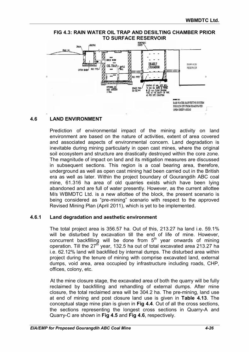
WBMDTC Ltd.
EIA/EMP for Proposed Gourangdih ABC Coal Mine 4-26
FIG 4.3: RAIN WATER OIL TRAP AND DESILTING CHAMBER PRIOR TO SURFACE RESERVOIR
4.6 LAND ENVIRONMENT
Prediction of environmental impact of the mining activity on land
environment are based on the nature of activities, extent of area covered and associated aspects of environmental concern. Land degradation is inevitable during mining particularly in open cast mines, where the original soil ecosystem and structure are drastically destroyed within the core zone. The magnitude of impact on land and its mitigation measures are discussed in subsequent sections. This region is a coal bearing area, therefore, underground as well as open cast mining had been carried out in the British era as well as later. Within the project boundary of Gourangdih ABC coal mine, 61.316 ha area of old quarries exists which have been lying abandoned and are full of water presently. However, as the current allottee M/s WBMDTC Ltd. is a new allottee of the block, the present scenario is being considered as “pre-mining” scenario with respect to the approved Revised Mining Plan (April 2011), which is yet to be implemented.
4.6.1 Land degradation and aesthetic environment The total project area is 356.57 ha. Out of this, 213.27 ha land i.e. 59.1%
will be disturbed by excavation till the end of life of mine. However, concurrent backfilling will be done from 5th year onwards of mining operation. Till the 27th year, 132.5 ha out of total excavated area 213.27 ha i.e. 62.12% land will backfilled by internal dumps. The disturbed area within project during the tenure of mining with comprise excavated land, external dumps, void area, area occupied by infrastructure including roads, CHP, offices, colony, etc.
At the mine closure stage, the excavated area of both the quarry will be fully reclaimed by backfilling and rehandling of external dumps. After mine closure, the total reclaimed area will be 304.2 ha. The pre-mining, land use at end of mining and post closure land use is given in Table 4.13. The conceptual stage mine plan is given in Fig 4.4. Out of all the cross sections,
the sections representing the longest cross sections in Quarry-A and Quarry-C are shown in Fig 4.5 and Fig 4.6, respectively.

WBMDTC Ltd.
EIA/EMP for Proposed Gourangdih ABC Coal Mine 4-27
TABLE 4.13 PRE MINING, AT END OF LIFE OF MINE AND POST MINE CLOSURE LAND USE
Pre Mining Land Use pattern Area (ha)
Land use at end of life of
mine
Area (ha)
Land use
Post closure
Post Mining Land Use (ha)
Planta-tion
Agricul-ture
Agro-forestry
Water Body
Public Use
Un-disturbed
Total
Agricultural Land 48.43 External OB Dump
62.97 External OB Dump
0.19 51.88 10.9 62.97
Fallow land (Danga) 44.07 Top soil Dump 13.73 Top soil Dump
13.73 13.73
Degraded land (Old quarry area) 61.316 Excavation 213.27 Excavation 213.27 213.27
Built up area 60.86 Roads 8 Roads 4 4 8
Water body 15.44 Built up area 27.23 Built up area 10.23 17 27.23
Forest land (protected & jungle) 109.459 Green Belt 7.52 Green Belt 7.52 7.52
Non agricultural land for colony (outside core area)
5 Undisturbed Area
23.85 Undisturbed Area
23.85 23.85
Non agricultural land for Rehabilitation (outside core area)
12
Total 356.575 Total 356.57 31.56 65.61 238.4 0 21 0 356.57
Source- Approved Mining Plan, FC Application & WBMDTCL

WBMDTC Ltd.
EIA/EMP for Proposed Gourangdih ABC Coal Mine 4-28
FIG 4.4: CONCEPTUAL PLAN
Source: Approved Revised Mining Plan, April 2011

WBMDTC Ltd.
EIA/EMP for Proposed Gourangdih ABC Coal Mine 4-29
FIG 4.5: CROSS SECTIONS OF QUARRY-A
Source: Approved Revised Mining Plan, April 2011

WBMDTC Ltd.
EIA/EMP for Proposed Gourangdih ABC Coal Mine 4-30
FIG 4.6: CROSS SECTIONS OF QUARRY-C
Source: Approved Revised Mining Plan, April 2011

WBMDTC Ltd.
EIA/EMP for Proposed Gourangdih ABC Coal Mine 4-31
4.6.2 Land management
Land degradation is one of the major adverse outcomes of opencast mining activities and any effort to control adverse impacts is considered incomplete when appropriate land reclamation strategy is not adopted. Since the land degradation in this mine will be partly in the form of excavated void and partly in the form of external dumps, the reclamation strategy must include a programme for the reclamation of the disturbed land. Therefore, the stage wise land use and reclamation has been prepared from the land use tables in approved Revised Mining Plan and Mine Closure Plan as well Table 4.13. The stage wise land use and reclamation can be seen in Table 4.14.
TABLE 4.14 STAGE-WISE LANDUSE AND RECLAMATION AREA (HA)
Sl. No.
Landuse category 5th
year 10th
year
15th
year
27th
year (End of Life
of Mine)
Post Mine
closure
1. Backfilled Area (Reclaimed with plantation)
16.8 60.5 85.45 132.5 213.27
2. Excavated Area (not reclaimed)/ void
71.2 94.8 92.55 80.77 0
3. External OB dump Reclaimed with plantation)
60.5 62.57 62.97 62.97 62.97
4. Reclaimed top soil dump 11 13.73 13.73 13.73 13.73
5. Green belt area (in 7.5 m safety zone)
7.52 7.52 7.52 7.52 7.52
6. Undisturbed area (brought under plantation)
23.85 23.85 23.85 23.85 23.85
7. Undisturbed area within project area without plantation
130.47 58.37 35.27 0 0
8. Roads (Avenue plantation) 8 8 8 8 4
9. Area around building and infrastructure (10.23 ha) (including workers colony 5 ha and 12 ha rehabilitation colony)
27.23 27.23 27.23 27.23 17
10. Disturbed area (reclaimed from roads 4 ha and built up area 10.23 ha)
14.23
Total 356.57 356.57 356.57 356.57 356.57 Source- Approved Mining Plan, FC application & WBMDTCL
The post mine closure land use of project area shows that all the disturbed
areas will be reclaimed before abandoning the mine including two voids of 80.77 ha having depth 120 m in Gourangdih-A and 210 m in Gourangdih-C, left at the end of the mining operations.
Transportation and unloading of top soil at green belt or reclamation site will
be undertake. It will be levelled before plantation/ agriculture/ agro-forestry. It will be preferred to bring topsoil directly from the freshly excavated area to extract maximum benefit. It is proposed to lay about 0.5-1m thick layer of top soil during leveling. In case of OB dumps, after leveling by the dozers, topsoil will be laid over it for reclamation. In case the soil is not adequate,

WBMDTC Ltd.
EIA/EMP for Proposed Gourangdih ABC Coal Mine 4-32
the deficiency will be made up from the top soil stack. Reclamation programme will be done simultaneously with mining.
4.6.2.1 Impact on & Management of agricultural land/ forestland/ grazing land The pre mining and land use at end of life of mine can be seen in Table
4.13. Agricultural land: The pre-mining land records of project area show 48.43
ha agricultural land within the project area. The location of these agricultural lands can be seen in Fig 3.11 of Chapter 3. This land use will be changed due to opencast mining activities. An important aspect of the mitigating the impact on agricultural land is to attempt to save the fertile top soil. For that purpose, the mine plan has provisioned for 3.19 Mcum of top soil to be removed during the life of the mine and to be stacked separately in soft OB i.e. top soil dump. This top soil will be simultaneously reutilized in plantation of green belt along periphery and in safety zone. Once the simultaneous backfilling of mine void commences from 5th year, the reclamation process over the backfilled area will also commence. Reclamation of external OB dumps as well as top soil dump will also eventually take place. The reclaimed area will be 238.4 ha under agro-forestry, 0.19 ha under plantation and 65.61 ha under agriculture. At the end of life of the mine the total afforested area will be 304.2 ha comprising 62.97 ha external OB dump, 13.73 top soil dump, 213.27 ha excavation, 4 ha roads and 10.23 ha built up area. After closure of mine, 48.43 ha of affected agricultural land (of pre-mining stage) will be compensated by 65.61 ha. Thus, after 27 year, the overall agriculture area will increase.
Another impact that can be felt will be in on the agricultural land adjoining
the project boundary. Agricultural land is less in south west to south east directions of the project. This region is engaged in colliery activities and several mines of ECL are existing in the immediate vicinity. Due to mining operations, dust will get airborne and according to wind direction, will occasionally fall on the agricultural fields along entire northern boundary. It is a well studied phenomenon that the impact of dust on any vegetation is that it reduces productivity. Although the Fugitive Dust Model predicts ground level concentrations within permissible limit as per NAAQS 2009, still, it becomes imperative that the control measures for fugitive dust control are implemented stringently to ensure that dust spreading to surrounding areas is minimal or negligible.
Forest Land: The pre-mining land records of project area show 109.459 ha
forest land (protected & jungle) within the project area. These forests are going to get disturbed due to mining activities. The application for seeking prior approval of Central Government under section 2 of the Forest (Conservation) Act, 1980 for Diversion of fresh forest area has already been submitted and is under process. Even though 109.459 ha forest will get disturbed, after closure of mine and carrying out reclamation, 238.4 ha of land is proposed user agro-forestry. Although the nature of the forest will change from the current natural forest to one which has more economical

WBMDTC Ltd.
EIA/EMP for Proposed Gourangdih ABC Coal Mine 4-33
value as it will be planted with the intent to harvest forest-produce. Therefore, the intent of the company is to replace the 109.459 ha with 238.4 ha of forests after closure of mine.
The nearest forest area outside the project area is PF near Narayanpur at
600 m in north east. The impact of the dust and gases due to mining activities are not anticipated to be of any significance at such a distance.
Grazing land: There is no separately designated grazing land. Villagers
tend to graze their cattle in uncultivated land. These land uses will be changed due to opencast mining activities. The company will carry out the following activities to offset the impact for grazing animals:
� Identify patches on government land near villages where fodder can
be grown. The company will provide monetary support to the committee formulated by the villagers for managing the identified fodder cultivation patch
� Company will arrange for interaction and training with agriculture experts for villagers to generate exposure about fodder crops and the potential of cultivation in non-crop season.
4.7 SOLID WASTE GENERATION AND MANAGEMENT 4.7.1 Impact
After the major impacts on land, air and water, mines also have a major impact due to generation of solid wastes. Production of solid waste can cause an impact on topography, land use and quality, air pollution, water contamination and visual aesthetics if proper management is not adopted.
Various types of solid waste will be generated from the mine as follows:
� Top Soil: The total topsoil (also referred to as soft OB in approved
Revised Mining Plan) generated will be 3.19 Mcum during the life of the mine. The year wise cumulative generation of the soft OB can be seen in Table 4.15. Displacement of soil will lead to the loss of its fertility if proper management is not adopted. In the process of displacement, sustainability of soil as a plant growth medium gets affected due to change in the soil structure by excavation and dumping, leaching out of nutrients due to rain, erosion due to both wind and water and loss of characteristics when required to be stored over long periods of time. In case, no mitigation measures are taken, top soil and/ or its sustainability of soil as a plant growth medium will be lost.
� Overburden: The total quantity of OB including access trenches has
been estimated as 179.37 Mcum, which includes 176.18 Mcum of hard OB and 3.19 Mcum of soft OB (i.e. top soil). Year/ stage wise waste generation of Hard OB & Soft OB (Top Soil) is given in Table 4.15.

WBMDTC Ltd.
EIA/EMP for Proposed Gourangdih ABC Coal Mine 4-34
TABLE 4.15 YEAR/ STAGE WISE QUANTITIES OF HARD & SOFT OB (TOP SOIL)
Year of Mining
Operation
External Dump
Hard OB (Mcum)
Internal Dump Hard OB (Mcum)
External Dump Soft OB or Top
Soil (Mcum)
Internal Dump
Soft OB or Top Soil (Mcum)
Soft OB or Top Soil
reclaimed over External
OB dump
Soft OB or Top Soil
reclaimed over Internal
OB dump
Qty. in Mcum
Area in ha
Qty. in Mcum
Area in ha
Qty. in Mcum
Area in ha
Qty. in Mcum
Area in ha
Qty. in Mcum
Area in ha
Qty. in Mcum
Area in ha
Initial mine cut / 1
st
year
2.35 13.75 0 0 0.15 1.25 0 0 0 0 0 0
2nd
year 7.35 18.21 0 0 0.4 2.79 0 0 0 0 0 0
3rd
year 14.24 42.59 0 0 0.71 5.41 0 0 0 0 0 0
4th year 21.16 52.57 0 0 1.04 8.03 0 0 0 0 0 0
5th year 23.61 60.5 4.52 16.8 1.32 11 0 0 0.02 1.25 0 0
10th year 39.64 62.57 24 60.5 2.06 13.73 0 0 0.04 2.79 0 0
15th year 47.1 62.97 52.17 85.45 2.68 13.73 0 0 0.08 5.41 0 0
20th year 47.1 62.97 88.01 104 3.09 13.73 0.01 2 0.12 8.03 0 0
27th year
Final stage 47.1 62.97 129.08 112.5 3.09 13.73 0.1 20 0.17 11 0.25 16.8
Total 47.1 62.97 129.08 112.5 3.09 13.73 0.1 20 0.17 11 0.25 16.8
Source:- Table 3.18 of Approved Mine Closure Plan for Gourangdih ABC coal block, May 2011
� Sludge from septic tanks/ STP: In the mines, septic tanks will be
provided. The sludge generation has been estimated at the rate of 10 g/capita/day for 762 manpower it will be 7.62 kg/day. The sludge will be removed periodically, say, every one year. Thus, for 330 days of operation, the likely desludging will be 2514 kg/yr or 2.5 TPA. A colony for 1350 persons has also been envisaged. The colony will be provided with an STP. This will have approximately 35 gm/capita/day sludge collection i.e. 47.25 kg/ day or 17.25 TPA. This sludge will be removed from the STP and either dried in sludge drying beds or concentrated using filter press. It will then be used as manure after composting.
� Surface settling pond sludge: Water from mine sump will be pumped
out to surface settling pond. The water from the garland drains around working pits or contour drains on the dump will be led to settling ponds. Therefore, more than one settling pond will be present in the project site for Gourangdih-A and Gourangdih-C. The suspended solids will settle in settling tank, the quantity of which will be variable and subject to rainfall and erosion. The siltation from the excavation and dumping has been estimated without and with mitigation measures as explained in section 4.7.3. With cropping and supporting conservative practices the annual soil loss has been estimated as 852.85 tonnes/annum. Majority of this is likely to get trapped in the sedimentation tanks. The sediment collected will be dredged and disposed in the OB dumps.
� Municipal Solid Waste: In the mine, this is expected to be 100 gm/ capita per day. Thus, for 762 manpower, it is expected to be 76.2

WBMDTC Ltd.
EIA/EMP for Proposed Gourangdih ABC Coal Mine 4-35
kg/day. For 330 days per year, this comes to approximately 25 TPA. A colony for 1350 persons has also been envisaged. This will have approximately 350 gm/capita/day solid waste generation i.e. 472.5 kg/ day or 172.5 TPA.
� Oil & grease: These will be generated due to vehicle washing, maintenance in workshop, etc. Assuming that the waste water from vehicle washing will contain 50 mg/l which has to be treated to 10 mg/l of oil and grease, for 40 KLD water required in workshop, the oil and grease removal would be (50-10)x40000x10-6=1.6 kg/day or 528 kg/annum.
4.7.2 Management of solid waste
� The total topsoil generated will be 3.19 Mcum during the life of the
mine. Mitigation or control measures are necessary to: � To prevent soil erosion and washing of fines from freshly excavated
benches and dumps � Temporary storage of top soil to maintain its fertility � Reuse of top soil
Therefore, the following mitigation measures are proposed:
� The top soil will be removed prior to excavation, dumping or any disturbance (such as construction) in any area. It will be collected and taken to the designated top soil dump area. In case there is ongoing plantation in greenbelt, along road side, around infrastructure area, over Hard OB dump or on backfilled area for reclamation, the top soil will be taken directly there, if needed.
� Simultaneous utilisation of top soil will be preferred to storage to maximise the benefit of fertility of top soil. However, in case top soil needs to be stored, precautions have to be taken as discussed below.
� Top soil storage: Stockpiling techniques and the wholesale removal of the topsoil layers, reduce the plant fragments from pre-existing vegetation, microbes become highly competitive as the base of stockpiles become anaerobic (due to compaction and more height), there is marked drop in the earthworm population and there are deleterious changes in soil nutrients, bulk density and water holding capacity. In order to mediate some of the damages caused by stockpiling, new and revised techniques are being used. For optimum survival of mycorrhizal propagules, the depth of stockpiles should be restricted to the rooting depth of covering vegetation. Depth is important, but the duration of storage is also a major factor in maintaining soil health and productivity. Shallow, bermed stockpiles are more useful to allow for better soil health. Another technique that will allow for greater success of stockpiling is to re-spread topsoil at the same depth or greater than what existed pre-disturbance. Soil inoculation with the mycorrhizal fungi that existed pre-disturbance is also a technique currently being used with some success.

WBMDTC Ltd.
EIA/EMP for Proposed Gourangdih ABC Coal Mine 4-36
� Garland drains followed by settling tank will be provided around the top soil dump to arrest any soil from the dump from being carried away by the rain water.
� The top soil dump will be stabilised on non working faces through plantation or geo-textiles to minimise gully formation
� Retaining walls (with gabion, concrete or local stone) will be provided, wherever required, to prevent the dump from sliding.
� OB management shall be as follows:
� The overburden is proposed to be dumped both externally and internally for concurrent backfilling.
� In Gourangdih A which will be started first, the initial OB will be dumped over the already de-coaled area of Khoirabad Colliery.
� Gourangdih C will start dumping over the vacant space in the north of the quarry.
� Initially upto 4th year the OB generated will be dumped at external OB dump fully over an area of 71.50 ha. Thereafter i. e. from the 5th year itself, OB generated will be dumped both externally as well as internally for backfilling.
� At the end of mining operation after 27 years of project life, the total volume of internal dump will be 129.18 Mcum over an area of 132.50 Ha (Hard OB and soft OB, both).
� At the end of mining operation the height of external dumps and internal dumps would be about 85 and 60 m above adjacent ground level.
� However, at the mine closure stage, the dump will be regraded so as to make the top of the dumps nearly level with adjacent ground topography. The areas of both the quarries will be fully reclaimed.
� While the external dumps exist, the following mitigation measures will be required to minimise erosion:
� Retaining walls (with gabion, concrete or local stone) will be provided, wherever required, to support the benches or any loose material and also to arrest sliding of loose debris.
� Garland drains along the retaining walls or along bench contours leading to settling tank will be provided around the OB dump to arrest any particles from the dump area from being carried away by the rain water.
� The bench levels will be provided with water gradient against the general pit slope to decrease the speed of storm water and prevent its uncontrolled descent.

WBMDTC Ltd.
EIA/EMP for Proposed Gourangdih ABC Coal Mine 4-37
� Special local stone paved chutes and channels will be provided wherever required, to allow controlled descent of water
� Gullies formed, if any, on side of the benches shall be provided with check dams of local stone or sand filled bags.
� The inactive dump slopes will be planted with bushes, grass, shrubs and trees to prevent soil erosion after applying topsoil.
External dumps to be rehandled and backfilled can be seen in Final stage
dump plan and Mine closure plan given in Fig 4.7 and Fig 4.8, respectively.
� Stability of OB Dumps
As per approved mine plan, OB will be dumped in the external and internal
dumping area at the natural angle of response to avoid sliding of OB. OB dump will be terraced at interval of 30 m height. The barrier distance between internal dump and coal production bench will be maintained at a minimum of 100 m to have smooth functioning of the machines. The surface of OB dump will be leveled and graded. Afforestration will be done on the slope of OB dumps for consolidation. The slope of OB dump will not be steeper than 28° from the horizontal, which will ensure that the dumps remain stable. The sections of final dumps in relation to the adjacent area can be seen in FIG 4.9.
As per section 6.8 of approved revised Mining Plan (April 2011), the height
of the dump and dump slope has been planned keeping in view the geo-technical characteristics of dump material and the dump floor inclination during different stages of mine operation. WBMDTC Ltd. has already initiated action and scientific study for stability of ultimate pit and dump slopes is being carried out by NIT Durgapur.
The following safety measures will be undertaken to improve the stability of OB dumps:
� Alluvium material will be dumped separately to prevent mixing with
hard rock waste material.
� After mining of coal, a layer of crushed rock, left out crushed coal and water lies on the de-coaled quarry floor. This hetrogeneous mixture is termed as interface material. This interface material covering the inclined quarry floor may be one of the major causes of any internal dump failure. Before, backfilling, this interface material shall be cleaned with a dozer.
� Garland drains shall be provided around the pit and the external dumps to divert the flow of water. Measures will be taken to prevent build up of pore pressure.

WBMDTC Ltd.
EIA/EMP for Proposed Gourangdih ABC Coal Mine 4-38
FIG 4.7: FINAL STAGE DUMP PLAN
External OB dump to be rehandled &
backfilled after mine closure
Internal OB dumps & backfill
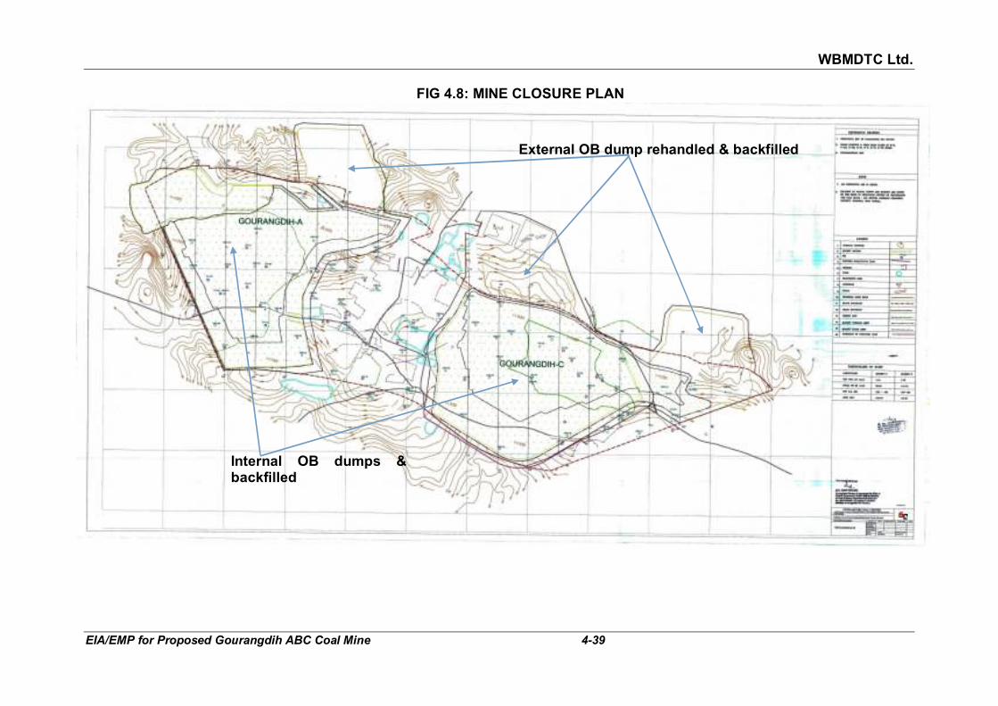
WBMDTC Ltd.
EIA/EMP for Proposed Gourangdih ABC Coal Mine 4-39
FIG 4.8: MINE CLOSURE PLAN
External OB dump rehandled & backfilled
Internal OB dumps & backfilled

WBMDTC Ltd.
EIA/EMP for Proposed Gourangdih ABC Coal Mine 4-40
FIG 4.9: SECTIONS OF FINAL DUMPS

WBMDTC Ltd.
EIA/EMP for Proposed Gourangdih ABC Coal Mine 4-41
� The sludge removed periodically from the septic tanks in the mining area would be organic in nature. The STP sludge from colony would also be organic in nature. The organic matter will be composted to be used as manure in afforestation/ greenbelt/ agroforestry/ agriculture.
� The silt and soil sludge in settling ponds will be periodically removed and disposed in the OB dump area.
� The municipal solid waste comprises of (i) organic, (ii) inorganic or recyclable and (iii) non-biodegradable components. The waste shall be segregated at source and the organic component shall be composted at the designated site within the project area. The composted matter will be used as manure in plantation. The inorganic or recyclable wastes shall be sold to recycling vendors. The non biodegradable waste, which can be minimised to less than 10% of the total waste through practice of 3Rs, will be given to the municipal corporation for disposal in their designated land fill site.
� The oil and grease removed shall be sold to SPCB/ CPCB authorised vendors.
4.7.3 Sediment load
The quantum of sand load carried by water depends upon the magnitude of flow, rainfall intensity, nature of formation, vegetation cover and slope. The adverse impact caused due to movement of sediment and land degradation need to be managed. To draw mitigation plan the quantum of sediment needs to be estimated on account of mining activity. The standard method for estimation of water erosion and sediment removal is by universal equation developed by U.S. Dept of Agriculture, which is as under.
A = RKLSCP
Where
A = Average annual soil loss tonnes/ ha
R = Rainfall factor = ΣKEI
100
KE = 210.3 + 89 log I
I = Rainfall intensity in cm/hour
L = Length of slope
S = Steepness factor
C = Cropping & Margent factor
K = Soil erodibility factor
P = Supporting conservative practices

WBMDTC Ltd.
EIA/EMP for Proposed Gourangdih ABC Coal Mine 4-42
The soil erodibility factor is 0.03 (for sand with OM<2% as per Table no 13.3, Page no 349 of Transportation Decision Making: Principles of Project Evaluation and Programming By Kumares C. Sinha, Samuel Labi). To evaluate rainfall intensity continuous rainfall record would be required, but based on available data from IMD for Bankura (MO), highest rainfall experienced in a day was 292.4 mm. This translates to 12.18 mm/hr for 24 hrs rainfall.
R = (210.3 + 89 log 1.218) X 1.218
= 2.65 100
The steepness factor has been taken as 0.4 since the dump slope is kept as
2.5/1. Total length of slope has been measured from 10th year stage plan for the waste dump with largest surface area (A1, lying north of Quarry A). The length from top of dump to the entry of the Quarry A is 1261 m. Similarly, the longest length of slope is in Quarry C between GRD-58 to GRD-61 and comes to 294 m. The cropping management & supporting conservation practice has not been considered with mitigation. In mitigation measure the value of each is taken as 0.5.
The dumps are the main source of generation of sediment load in mining
industry. The sediment has been worked out based on aforesaid method under normal condition and after mitigation measures such as compaction, garland canal desiltation chambers/ pits are constructed and plantation is done. The silt load mine pit at the end of 10th year of mining has been evaluated and given in Table 4.16. The silt / sediment load settles down in
settling tank most of the time, except when sufficient time does not elapse during rains. The sediment load will be dredged and disposed in the OB dumps.
TABLE 4.16
SEDIMENT LOAD (TONNE)
Source Average annual soil loss, tonnes/Hectare
Area in
10th Year, ha
Total annual soil loss, tonnes
Without mitigation
With mitigation
Without mitigation
With mitigation
Waste dump 40.10 10.02 62.97 2525.08 631.27
Pit 9.35 2.34 94.80 886.30 221.58
Total 3411.38 852.85
4.8 NOISE 4.8.1 Impact due to noise The proposed excavators, blasting, pumps, dumpers and trucks would be
the major noise sources. The entry gate area will be highly traffic-affected and hence, it will be a noise prone area in addition to the mine’s working face(s).

WBMDTC Ltd.
EIA/EMP for Proposed Gourangdih ABC Coal Mine 4-43
Operation of machines & vehicles will continuously generate noise, which will have adverse impact on the ambient noise levels. However, the adverse impact is anticipated to be limited to the mining lease area and its immediate surroundings. The adverse impact can be more within the mining lease area, and may cause hearing loss and other related problems to the workmen, if mitigation through protective measures are not taken. Impact can be there on the local people of nearest settlements i.e. on thickly populated Gourangdih B sub block. The mitigation measures are discussed subsequently.
Noise propagation through mathematical model and impacts of noise with
distance from source has been studied and brought out below. As the equipment/ vehicles generate noise generally in the range of 100 dB
(A) at source, it can be safely assumed that the ambient noise levels on any point of boundary line of lease are not higher than 100 dB(A). It has, also been assumed that the area within a distance of 3-5 m (say) from noise generating machines/ vehicles will be termed as point noise source to avoid complication in the absence of availability of exact location of various noise generating units, their arrangements and shapes. Taking an extreme case of two machines/ vehicles, each generating 100 dB (A), working at a point will add up to 103 dB(A) overall noise level. Such source noise level has been considered here for anticipating the impacts. Noise attenuation with distance in all directions over flat open bare ground is given by
Sound level dB (A) = Lw – 20 log10R - 8 Where: LW = Sound level of source, dB (A) assumed 103 dB (A) R = Source distance, m The same has been plotted in Fig 4.10 assuming source noise level as 103
dB (A).
FIG 4.10: NOISE ATTENUATION WITH DISTANCE IN ALL DIRECTIONS OVER FLAT OPEN BARE GROUND (SOUND AT SOURCE = 103 DBA)

WBMDTC Ltd.
EIA/EMP for Proposed Gourangdih ABC Coal Mine 4-44
A perusal of graph shows that the sound levels attenuate to values as shown in Table 4.17.
TABLE 4.17
NOISE ATTENUATION WITH DISTANCE ON FLAT BARE GROUND WITHOUT AND WITH GREEN BELT
COMBINED NOISE OF MORE THAN ONE SOURCE = 103 DB (A)
Distance from source (m)
Noise level reduced from 103 dB(A)
Without green belt, dB(A) With green belt, dB(A)
20 70.0 68.5
60 60.0 55.5
100 56.0 49.0
150 52.0 41.0
180 50.0 33.0
300 45.0 <33.0
It means that after distance of about 300 m, the machine/ vehicle noise will
merge into the background noise in the day time, even in the absence of a greenbelt. This noise level is same as the limit [45 dB (A)] prescribed by The Noise Pollution (Regulation And Control) Rules, 2000 at night time for residential areas. Due to plantation along the roads and periphery of lease, it will be possible to further lower the noise levels below the prescribed limits or to reduce the distance at which the noise attenuates to 45 dB(A).
Due to operation of heavy machines and vehicles during mining operation,
ambient noise level is likely to increase leading to impact on the workforce. Impact on the workforce can affect the TLV of hearing of those deployed close to the machines and at the secondary stage to neuro problems. The activities, in case of no environmental management measures are taken, can cause severe impacts on the health of the workforce. Hence, the noise levels will regularly be measured near the operational machines and vehicles and will be kept to a minimum so that the noise level will be within the permissible limits for 8 hour exposure limited by OSHA (refer Annexure X).
The noise from mining and associated activities also disturbs animals/ birds
living in the surroundings forcing them to change their habitation. The lease area has 109.459 ha forest land as per land records, which will be diverted for excavation or dumping. The nearest existing forest is the protected forest near Narayanpur at a distance of 0.6 km in North-East. No direct impact of noise is anticipated on the nearest forest.
4.8.2 Noise pollution control measures The following control measures will be adopted during operation phase to
keep the ambient noise levels below permissible limits:

WBMDTC Ltd.
EIA/EMP for Proposed Gourangdih ABC Coal Mine 4-45
� For the protection of the nearest settlement in Gourangdih-B area, a provision of 45 m wide safety barrier has been made on both sides of Gourangdih-B block. This safety zone is proposed to be afforested. The afforested 45 m belt will act as a buffer to absorb noise and dust from Quarry-A and Quarry-C. The map showing the 45 m safety barrier can be seen in Fig 4.11.
� Dense green belt around the opencast working has been proposed. Further, provision of greenbelt around CHP/ crusher, mine infrastructures and both sides of haul road on the surface has been made. With the above measures, noise level at colonies and nearest habitation site is not expected to be above the permissible limit at night.
� Fitting of special silencer, proper lubrication and periodic maintenance of noise generating machinery and transportation vehicles will be ensured.
� To protect the workers from exposures to higher noise levels, the following measures will be adopted:
� Provision of protective devices like ear muffs/ear plugs to those workers who cannot be isolated from the source of noise.
� Confining the noise by isolating the source of noise.
� Reducing the exposure time of workers to the higher noise levels.
� The operators of stripping and coal winning equipment will be accommodated in cabins which are acoustically designed and air conditioned. It forms a part of the equipment so that level of sound inside the cabin is below 90 dB(A).
� For CHP/ Crusher, where the crushing and other vibrating equipment
will generate noise level of around 85-90 dB (A), the following measures will be taken:
� The crushing and vibrating equipment will be in a covered building, thus, reducing noise propagation to the surrounding area.
� Noise absorbent and anti vibration paddings have been proposed between foundation and base plate of the machinery.
� Chutes at transfer points in coal handling plant shall be lined properly for noise absorption.
� Regular maintenance and prompt replacement of worn out parts shall be ensured.
� The workers exposed to high noise levels will be provided with earplugs / ear muffs.
� Plantation will be done in and around the CHP/ crusher premises to attenuate any residual noise.

WBMDTC Ltd.
EIA/EMP for Proposed Gourangdih ABC Coal Mine 4-46
FIG 4.11: THE MAP SHOWING 45 M WIDE AFFORESTATION ON BOTH SIDE OF GOURANGDIH-B BLOCK

WBMDTC Ltd.
EIA/EMP for Proposed Gourangdih ABC Coal Mine 4-47
4.9 GROUND VIBRATIONS- IMPACT AND MANAGEMENT Blasting has been proposed in this mine to remove the hard strata by using
control blasting techniques. Thus, flying fragments due to blasting or vibration and secondary cracking of structures on the surface may be there if the blast are not regulated as per control blasting techniques. Blasting will follow the recommended patterns and norms.
In the mining plan, due to close proximity of the project to thickly populated
village i.e. Gourangdih and Panuriya, restriction are anticipated in regard to blasting. The restriction are anticipated on the basis of the studies conducted in Tara OCP situated about 5 km away from the proposed block. As per the study, for a maximum peak particle velocity of 0.3 mm/sec, mining operation is planned upto a distance of 100 m from the village boundary with a maximum charge per round 2 te, maximum charge per delay 200 kg and maximum depth of hole 12 m. (Source: Section 7.4.1 of approved Revised Mining Plan, April 2011).
In view of the above, Controlled blasting techniques including muffled blasting will have to be adopted during blasting within 500 m zone as per CMR, 2017 but beyond 100 m from the village, dwellings, surface structures, road etc after obtaining approvals from the Chief Inspector. Total quantity of explosives to be detonated at a time will be regulated so that ground vibration which may affect the nearby surface structures, are kept within the stipulated limit. The limiting values prescribed by DGMS, Dhanbad (Circular No. 7 dated 29 -08-1997) are given in Table 4.18.
TABLE 4.18 PERMISSIBLE PEAK PARTICLE VELOCITY (PPV) AT THE FOUNDATION
LEVEL OF STRUCTURES IN MINING AREAS IN MM/SEC
Type of structure Dominant excitation frequency Hz
<8 Hz 8-25 Hz >25 Hz
A. Buildings/structures not belonging to owner
Domestic houses /structures (Kuchha brick and cement)
5 10 15
Industrial buildings (RCC and framed structures)
10 20 25
Objects of historical Importance and sensitive structures.
2 5 10
B. Building belonging to owner with limited span of life
Domestic houses/structures (Kuchha brick and cement)
10 15 25
Industrial buildings (RCC and framed structures)
15 25 50
The ground vibrations from the planned charge per blast round, shall be
within limits for existing structures.

WBMDTC Ltd.
EIA/EMP for Proposed Gourangdih ABC Coal Mine 4-48
Apart from above, general recommendations and suggestion for reducing ground vibrations due to blasting are as follows:
� Drilling and charging pattern will be modified, if required, based on
any vibration study to be carried out in future.
� Short delay detonators will preferably be used in blasting rounds rather than detonating fuse as trunk line.
� To contain fly rocks, stemming column will not be less than burden of the hole and the blasting area will be muffled.
� Each blast will be carefully planned, checked, executed and observed. Blasting data will be recorded. During blasting, a responsible officer will be supervising the whole operation.
� Blasting will be carried out during day time only.
� Blasting will not be carried out when strong winds are blowing towards the inhabited areas.
Apart from the above, in order to ensure slope stabilisation, controlled
production blasting will be adopted to avoid tension cracks and back breaks. Such cracks filled with water reduce stability of excavated slopes and angle of slopes. Good drainage system will be provided in and around the mine.
4.10 IMPACT DUE TO TRAFFIC
4.10.1 Impact due to traffic
There in only one outgoing material, which is coal. The transportation shall
be carried out through road either directly to end user or till railway siding by tipping trucks/ dumper having capacity 25 T. Total material to be transported is estimated around 7576 TPD (assuming total working days as 330 and production 2.5 MT of coal in a year). Since the end users will be various industries across the different states, hence the direction of movement of trucks cannot be exactly identified. Certain assumptions have been made with respect to the routes shown in Fig 4.12. The assumptions made are as follows:
� Transportation of coal directly till end user by road via Asansol-
Gourangdih road. 1 MTPA coal shall be transported through this road. Approximately 244 trucks (to and fro) will move through this road. This route has been called as “Route-2” in Fig 4.12.
� Transportation of coal via road to any of the four railway sidings,
namely, Bonjemehari, Barabani, Charanpur or Chinchuria railway siding. Approximately 1.5 MTPA will be moved to consumers through this road-rail combination. Approximately 364 trucks will move on these routes called as Route 1, Route 3, Route 4 and Route 5 of Fig 4.12.

WBMDTC Ltd.
EIA/EMP for Proposed Gourangdih ABC Coal Mine 4-49
FIG 4.12: THE PROPOSED RAILWAY SIDING AND CONNECTING ROADS TO BE USED FOR TRANSPORTATION OF COAL

WBMDTC Ltd.
EIA/EMP for Proposed Gourangdih ABC Coal Mine 4-50
The traffic survey was conducted as per IRC: 9-1972 at three locations namely Baradang (T1), Majandih (T2) and Dharaspur (T3) in the up and down directions. The same is presented in section 3.10.2 of Chapter 3. Baradang location falls on Gourangdih-Asansol road (Route-2) and Dharaspur location falls on Rupnarayanpur-Gourangdih road i.e. connecting road (Route-1) to Bonjemehari railway siding through which coal transportation is proposed. There will be an impact on carrying capacity of these two roads due to additional traffic load. Therefore, the adequacy of the road to support the additional traffic, its maximum capacity and the percentage utilization of the maximum capacity has been calculated. This has been done with respect to existing and future traffic load and the increment in utilization of maximum capacity has been calculated in Table 4.19.
TABLE 4.19
OBSERVED EXISTING, ADDITIONAL TRAFFIC AND THEIR % UTILISATION
Code Location Existing Traffic
(PCU/Day) in
January, 2018
Additional traffic
proposed (PCU/Day)
Resultant traffic (PCU/ Day)
Width of road
DSV# PCU/ day
Maximum capacity (MC)##
in PCU/ day
% Utilization
Current in January, 2018
Resultant future
Incre-ment
a b c d e=b+c f g h i w.r.t c j w.r.t e k=j-i
T1 Baradang 5157 732 5889 5.8 m 6000 12000 42.975 49.1 6.1
T3 Dharaspur 2239 1092 3331 3 m 2000 4000 55.9 83.8 27.3 Note- # Design Service Volume (DSV) in PCU/day as per Table 3&4 of IRC:64-1990 ## Maximum capacity as per IRC 64-1990, section 6.1 = DSV/0.5, in PCU/day
It can be seen in the above table that the resultant traffic load on Asansol-
Gourangdig road (Route-2) at Baradang loacation will be 49.1 % of the Maximum capacity of the road. Where as on Rupnarayanpur-Gourangdih road (Route-1) at Dharaspur location, the resultant traffic load will be 83.8 % of Maximum capacity the roads. Thus it can be say that the current road width of both the location is sufficient to sustain the present and additional traffic.
Traffic from the mine will pass through the several villages falling within 10
km radius from the project (refer Table 4.20 below). Depending upon the route to be used at time of operation & transportation, habitation of these villages will get affected as truck transportation will contribute to marginal increase in noise level and air pollution.
TABLE 4.20
VILLAGES ALONG THE COAL TRANSPORTATION ROUTES
Till end user by road By road till railway siding
Route-2
Asansol-Gourangdih road
Route-1
Bonjemehari
Route-3
Chinchuria
Route-4
Barabani
Route-5
Charanpur
Jamgram Kashidangal Jamgram Jamgram Jamgram
Gourangdih Satta Natundihi Katindanga Sarishatali

WBMDTC Ltd.
EIA/EMP for Proposed Gourangdih ABC Coal Mine 4-51
Till end user by road By road till railway siding
Route-2
Asansol-Gourangdih road
Route-1
Bonjemehari
Route-3
Chinchuria
Route-4
Barabani
Route-5
Charanpur
Baradang Gholkiyari Katindanga Sarishatali Kapista
Amdiha Bodradih Rampur Kapista Madanpur
Baliapur Dharaspur Raghunath Chowk
Madanpur Khoshnagar
Shrirampur Rangamatiya Bijari Khoshnagar Madhudanga
Lalganj Kendwadih Kalidhura Madhudanga Shyamsundar pur
Baradanga Hatisdih Chinchuria Shyamsundar pur Faridpur
Asanbuni Basudebpur Faridpur Jitudaura
Panchgachhia Benjimari Jitudaura Charanpur
Charanpur
Total villages =10 Total villages =10 Total villages =8 Total villages =11 Total villages =10
Length: 12.7 km Length: 17.2 km via Gourangdih and 15.04 km via
kashidangal
Length: 16.4 km Length: 22.9 km via Shyamsundarpur and Faridpur and 11.7 km via Katindanga
Length: 20.9 km
The sound level from the movement of trucks passing on the road is approximately 90 dB(A). There will be a short time increase in the noise level during plying of the vehicles. The overall Leq noise level will be slightly higher. As the vehicle move away, the noise levels will be decreasing. As the distance increases from the line of trucks movement, the anticipated Leqs will be as follows:
NOISE ATTENUATION IN ALL DIRECTIONSOVER FLAT OPEN GROUND [SOUND AT SOURCE = 90 dB(A)]
35
45
55
65
75
85
95
0 10 20 30 40 50 60 70 80 90 100 110 120 130 140 150 160 170 180 190 200
DISTANCE FROM SOURCE (m)
SO
UN
D L
EV
EL
IN
dB
(A)
At a distance of 7 m, the Leq is anticipated to be approximately 65 dB(A), falling within the limits for commercial areas, which is the usual case along

WBMDTC Ltd.
EIA/EMP for Proposed Gourangdih ABC Coal Mine 4-52
roads. The anticipated noise levels due to movement of trucks through different routes have been discussed below Table 4.21.
TABLE 4.21
DISTANCE BETWEEN TWO TRUCKS FOR DIFFERENT ROUTES
Particulars Route-2 On any one of the Route-1, 3,
4 & 5.
(a) (b) (c)
Maximum no. of trucks on Route/day = 244 364
Maximum no. of trucks on Route/hr = 11 16
Speed of trucks (km/hr) = 40 40
Time after which another trucks will pass a particular point on the road (minute)
= 5.45 3.75
Distance covered by a trucks in 1 min (meter/min)
= 667 667
Distance between 2 consecutive trucks (approx. meters)
= 667 x 5.45 667X3.75
= 3635 2501
As per the Noise Pollution (Regulation And Control) Rules, 2000, the Leq noise level in residential areas during day is 55 dB(A) and at night is 45 dB(A). The noise levels due to movement of trucks on the route will increase slightly and the average noise levels will be slightly high. The noise level contour for Route 1 and for any one Route-2, 3, 4 and 5 when approximately 11 and 16 trucks per hour will be plying on the different routes is shown in Fig 4.13.
FIG 4.13: NOISE LEVEL CONTOUR FOR DIFFERENT ROUTES
It can be seen from Fig 4.13 that no overlapping of the sound waves
generated from two consecutive trucks will take place if the minimum distance between two trucks is > 400 m. which is not found in this case as
WBMDTC Ltd.
EIA/EMP for Proposed Gourangdih ABC Coal Mine 4-53
the minimum distance between two consecutive trucks will be 3635 m on Route-2 and 2501 m on any one routes of railway siding.
The emission from the trucks has been calculated and detailed in Annexure XXII. The ground level concentrations have been calculated using the CAL3QHCR model. The discussion on the same has been done in para 4.4.1 (ii) earlier. The maximum Incremental ground level concentrations
anticipated from road are 9.842 µg/m3 for PM10, 5.665 µg/m3 for PM2.5,
0.006 µg/m3 for SO2 and 0.040 µg/m3 for NO2. Since the highest
concentration observed in buffer zone are 78.0 µg/m3 for PM10, 45.3 µg/m3
for PM2.5, 12.1 µg/m3 for SO2 and 16.7 µg/m3 for NO2. Hence, The resultant
incremental ground level concentrations anticipated are 87.842 µg/m3 for
PM10, 50.965 µg/m3 for PM2.5, 12.106 µg/m3 for SO2 and 16.74 µg/m3 for NO2.
Hence, the resultant air quality value will be well within the prescribed limit as per NAAQS 2009.
4.10.2 Mitigation due to traffic
The mitigation measures will be taken for control of pollution due to
transportation as follows:
� Optimum weight to be carried by the truck and over loading prohibited
� Periodic maintenance of the truck as per manufacturers specifications for best fuel efficiency
� The transportation vehicles will under go for “Pollution Under Control (PUC)” checkups on every six months to obtain PUC certificate.
� Water sprinkling at load points and covering of trucks with tarpaulin will be ensured
� Water sprinkling on roads within project area
� Training to drivers and periodic awareness drives
� Safety week organization to sensitize the workers and drivers.
� Carry out plantation along the routes for dust and noise control on either side of road, where ever possible
4.10.2.1 Facilities for trucks & drivers Various facilities will be provisioned for the trucks and truck drivers as
follows:
� Designated parking area prior to loading and also after loading
� Designated space for loading
� Weigh bridges
� Rest rooms for drivers
� Canteen for all employees, which can also be availed by drivers
� Truck cleaning zone

WBMDTC Ltd.
EIA/EMP for Proposed Gourangdih ABC Coal Mine 4-54
4.10.2.2 Road diversion There are two existing road passing through the core zone namely,
(i) Road-1: Asansol-Gourangdih road connecting Runakura ghat via Jamgram is having width of about 7 m (PWD road), passing through
the eastern part of proposed Gourangdih C quarry. (ii) Road-2: Rupnarayanpur-Gourangdih road is having width of about 3
m (Village road), connecting Gourangdih and Rupnarayanpur, passing through the western portion of Gourangdih-A quarry.
These two roads will get excavated during mining operation. Hence, for uninterrupted traffic flow, diversion of these roads is necessary which shall be as follows: (i) Road-1: Asansol-Gourangdih road, connecting Asansol to
Runakuraghat via Jamgram village is proposed to be diverted towards further east of the Gourangdih quarry-C.
� Road-2: The Rupnarayanpur-Gourangdih road is proposed to be
diverted towards further west of the Gourangdih quarry-A and will be connected to Asansol-Gourangdih road.
Both the roads will be reconstructed after diversion to a road width
equivalent to their existing width. Apart from the road diversion, road from Gourangdih village to proposed
diversion of Rupnarayanpur-Gourangdih road (about 300 m in length), is also proposed to be made black topped/CC road (Road 3). Partly metalled road already exists on the road, which will have to be further strengthened.
The proposed diversion of Road-1 and 2 and strengthening of Road 3 are
shown in 15th year stage plan given in Fig 4.14.
The expense of diversion of both the Roads i.e Road 1&2 with their existing
cross-sections and strengthening of Road 3, will be borne by WBMDTC Ltd. Apart from the road diversion, road from Gourangdih village to proposed diversion of Rupnarayanpur-Gourangdih road (about 300 m in length), is also proposed to be made black topped/CC road. Partly metalled road already exists on that alignment, which will have to be further strengthened. This road has been called as Road-3 for strengthening purpose.
The impact will be there only on the path of the road due to alignment change but there will not be any adverse impact. Tree plantation is proposed along both the sides of the diverted road routes, which will act as an absorber of dust and noise pollution and also will improve the aesthetic view of the area.

WBMDTC Ltd.
EIA/EMP for Proposed Gourangdih ABC Coal Mine 4-55
FIG 4.14: 15TH YEAR STAGE PLAN SHOWING EXISTING ROADS (NO. 1&2) PASSING THROUGH ML AREA AND THE PROPOSED DIVERSION OF THESE ROADS AS WELL AS THE ROAD (NO. 3) TO BE STRENGTHENED

WBMDTC Ltd.
EIA/EMP for Proposed Gourangdih ABC Coal Mine 4-56
4.11 ECOLOGY
There are no National parks, Wildlife Sanctuary, Biospheres reserves or migratory corridor of any Schedule-1 species within 10 km radius. The nearest National Park is Simlipal at a distance of 228 km, SSW and nearest wildlife sanctuary is Ramnabagon at a distance of 70 km, SE. No endangered or endemic species of plant or animal is present in the study area. Thus, the impact on flora and fauna of the buffer zone will not be there as no mining activity will take place outside core area. List of flora and fauna in core and buffer zone is given in Annexure XIV & XV. Agricultural crops
and fruit trees form a part of the commonly found flora in the study area. Out of total mining lease area, 109.459 Ha (30.7% of the project area) is Forest Land (protected and jungle). Application for seeking Stage I Forest Clearance has been submitted vide Proposal No. FP/WB/MIN/26869/2017 dated 12.07.2017. The DGPS surveyed and geo referenced map of forest land use plan in Gourangdih ABC coal mine can be seen in Fig 3.11 (Land Ownership Map) of Chapter 3. There are 13 Protected Forests present in the study area and the list is given in Table 3.14 of chapter 3 of this report.
4.11.1 Impact on ecology Ecological impact from open cast mining result from generation of pollutants
both in air and water. Further excavation of soil causes damage to its structure and composition. The adverse impact of proposed mining activity will cause:
� Loss of vegetation by excavation and dumping thereby affecting the
species for which such vegetation was the host. � Movement of species away from mining lease area due to noise,
vibration and light.
The impact on the terrestrial ecosystem due to operation of the proposed mining would mainly occur from deposition of air pollutants. Particulates, sulphur dioxide and oxides of nitrogen are major pollutants from traffic. These pollutants affect biotic and abiotic components of the ecosystem individually and synergistically.
Chronic and acute effects on plants and animals may be induced when the concentration of these pollutants exceeds threshold limits. The dust particles depending upon their size and weight settle down at varying distances on vegetation and soil surfaces in the prevailing and direction. Foliar deposition of dust may interrupt gaseous exchange through stomatal clogging, thereby affecting plant growth. The effects of air emissions on nearby vegetation and crop lands are not likely to be adverse as the pollutants concentration is expected to be well within the prescribed standards.
Chronic exposure to SO2 causes injury characterized by yellowing of the leaf (Chlorosis). Scientific literatures reveal that low concentration of SO2

WBMDTC Ltd.
EIA/EMP for Proposed Gourangdih ABC Coal Mine 4-57
over long period lead to intravenal chlorosis in high humidity. However at higher concentrations, SO2 combines with moisture in the air to form aerosol which erodes cuticle and cell membrane, thus inviting easy entry of pathogens. It may alter the pH of the soil. Changes in pH of the soil may affect microflora and fauna of the soil. Acute injury is characterized by development of dry dead areas with an ivory to brown colour (necrosis). Taking a seasonal and annual average, the threshold for chronic plant
injury has been estimated at approximately 130 µg/m3 (A.J Dvorack and B G Lewis, 1978).
USEPA air quality criteria for SO2 stipulates 0.2 ppm (524 �g/m3) level when
visible injury to sensitive vegetation in humid regions after 3 hours exposure
is observed. In another case, level 0.5 ppm SO2 level (1310 �g/m3) for 1
hour exposure results in visible injury to sensitive vegetation in humid
regions. At higher SO2 concentration of 10 ppm (26214 �g/m3), visible injury
to vegetation in arid regions is observed. Such high ambient air concentration of sulphur dioxide, is not likely to occur in the area.
USEPA air quality criteria for NO2 stipulates 2 ppm (3760 �g/m3) level when
foliar injury to vegetation at 4 hours exposure is observed. At a lower NO2
concentration of 0.25 ppm (470 �g/m3) during the growing period, decrease
of growth and yield. Such high ambient air concentration of nitrogen dioxide is unlikely in the study area.
The cumulative 24-hour average incremental GLC from the proposed
Gourangdih ABC coal mine when added to the base line concentration of SO2 and NO2 observed in the study area would not be more than 38.225
µg/m3 and 48.190 µg/m3, respectively which is well within the National Ambient Air Quality Standards. Therefore it can be seen that these values are much lower than the threshold limits for damage to terrestrial flora and as such, the impact on the terrestrial ecosystem would be marginal.
The general adverse impacts, usually in case of mine are:
� Impact on species of flora and fauna in the form of relocation for their survival, due to diversion of proposed 109.459 ha forest land (Protected and Jungle).
� Dust emission from mine due to excavation and transportation, affects the effective photosynthesis by covering the plant/ tree leaves by thin dust layer during dry months which however will be washed away in rainy months.
� Disturbance to birds and animals due to bright light and unusual noise during operation activity.
� There may be discharge of excess unutilised pumped out mine water into the nearest natural stream after settlement of suspended solids. As the streams are seasonal and the discharge will also be during

WBMDTC Ltd.
EIA/EMP for Proposed Gourangdih ABC Coal Mine 4-58
monsoons, no major impact is envisaged on the surface water bodies and on the fresh water eco-system.
� The effluents generated from the mine will be treated and reused after complying with prescribed standards. Therefore, these too are not anticipated to impact ecology. In fact the waste water, after treatment, will be used for watering the plantation.
4.11.2 Management of ecology
� Compensatory afforestation: As per the application made for seeking prior approval of Central Government under section 2 of the Forest (Conservation) Act, 1980 for Diversion of fresh forest area, encumbrance free 111.32 Ha of government land has been provided by the Additional District Magistrate & District Land & Land Reform Officer, Purb Bardhman, on which compensatory plantation shall be done equivalent to trees that shall be removed for mining purpose.
� Green Belt: Plants act as natural sink for a variety of pollutants as
well as replenish air with fresh oxygen. Therefore, establishment of greenbelt and plantation along various facilities and periphery is an important aspect of mitigation plan under ecology. The main consideration during development of green belt and plantation are as follows:
� Effective trapping of dust and emissions
� Adequate dilution of accidental releases
� Noise absorption
� Balancing eco environment
� Waste water reuse
� Aesthetics
� fast growing, evergreen with large crown
As a single plant does not have all the qualities, a mixture of several varieties of plants has been chosen.
The widths of the belt will be 7.5 m all along the boundary. Plantation on 45 m safety zone between Quarry A and settlements of Panuriya and Gourandih as well as between Quarry C and these settlements shall be carried out.
� Other plantation: Plantation shall also be carried out along roadside
and around Administrative buildings, facilities and in vacant undisturbed areas as well.
� Reclamation plantation: The other measures for management of
ecology will comprise of mainly of plantation for rehabilitation. Once the simultaneous backfilling of mine void commences from 5th year, the reclamation process over the backfilled area will also commence.

WBMDTC Ltd.
EIA/EMP for Proposed Gourangdih ABC Coal Mine 4-59
Reclamation of external OB dumps as well as top soil dump will also eventually take place. The reclaimed area will be 238.4 ha under agro-forestry, 0.19 ha under plantation and 65.61 ha under agriculture. At the end of life of the mine the total afforested area will be 304.2 ha comprising 62.97 ha external OB dump, 13.73 top soil dump, 213.27 ha excavation, 4 ha roads and 10.23 ha built up area.
� Plantation program of mine: A plantation program over life of mine
has been planned in a phase wise manner. The plantation shall be started from first year of mining and till fifth year about twenty seven thousand trees shall be planted. The total plantation till the end of life of mine, shall be done on 226.84 ha., out of which 132.5 ha. will be backfilled area, 62.97 ha. external dump area, 7.52 ha. greenbelt and 23.85 ha will be others i.e. undisturbed area. The stage wise cumulative plantation are tabulated in Table 4.22.
TABLE 4.22
STAGE-WISE CUMULATIVE PLANTATION Sl. No.
Year* Greenbelt External Dump area
Backfilled Area Others (undisturbed area, etc)
Roads Built up area Total
Area (ha)
No. of trees
Area (ha)
No. of trees
Area (ha)
No. of trees
Area (ha)
No. of trees
Area (ha)
No. of trees
Area (ha)
No. of trees
Area (ha)
No. of trees
1 5th year 7.52 18800 60.5 151250 16.8 42000 23.85 59625 0 0 0 0 108.67 271675
2 10th year 7.52 18800 62.57 156425 60.5 151250 23.85 59625 0 0 0 0 154.44 386100
3 15th year 7.52 18800 62.97 157425 85.45 213625 23.85 59625 0 0 0 0 179.79 449475
4 27th year (end) 7.52 18800 62.97 157425 132.5 331250 23.85 59625 0 0 0 0 226.84 567100
5 Post Mine closure 7.52 18800 11.09 27725 213.27 533175 23.85 59625 4 10000 10.23 25575 269.96 674900
Note- density of tree plantation is proposed 2500 tree/ha (see EAC observation point xxii of TOR)
� Mitigation measures for safeguarding fauna: Some of the
precautionary and improvement measures proposed for protection of fauna are as follows:
� Establishment of greenbelt along the facilities and periphery will act
as a natural buffer between the surrounding area and the facilities. The greenbelt around facilities, periphery and along roads will result in small sized fauna such as squirrels, hare, etc., reptiles and birds in finding a favorable habitat.
� The roads leading to and from the mine shall have caution boards warning drivers to slow down for animal crossings, if any develop in the future.
� The drivers shall be sensitized not to hit stray animals on the road.
� The emissions from the mines shall always be kept within the norms so that surrounding environment will always be clean and comfortable for humans, wildlife and vegetation.
� Care shall be taken that no food or degradable waste is openly disposed. This could attract wild animals near to human habitation

WBMDTC Ltd.
EIA/EMP for Proposed Gourangdih ABC Coal Mine 4-60
and create man-animal conflict. Hence, disposal of wastes shall always be on the designated and protected place.
� The company shall interact with the Divisional Forest Officer and find out whether any schemes are ongoing for the protection of the wildlife. If such schemes are ongoing, then monetary or logistic support shall be extended by the company. For example, the company can supply water to watering holes in the forests in study area during dry season
� While carrying out social welfare activities, awareness about the variety of faunal species, their status of endangerment and behavior will be spread through posters/ seminars/workshops or discussions to sensitize the villagers. By gaining correct scientific information, the villagers will be in a better position to protect themselves from animals and in return will not harm them also. Such situation reduces, man-animal conflict, which usually arise due to myths and fear or hatred of animals.
� For minimizing coal fire, a well designed fire fighting system will be maintained within mine to deal with possibilities of fire. Water sprinklers and fire hydrants of adequate specification will be provisioned at strategic locations to deal with any emergency.
� Waste water from domestic sources (toilets/ canteens/ baths/ kitchens) will not be released into the environment but treated in septic tank system or STP. Thus, the flora and fauna shall not be exposed to any contaminants.
4.12 SOCIO-ECONOMIC IMPACTS AND MITIGATION INCLUDING
RESETTLEMENT AND REHABILITATION Impact
The project falls under seven villages which are Shibdhara, Bandhaura, Lalbandh in Block-A and part of Panuriya, Kantapahari, Gourangdih & Bhuiapara in Block-C. Total 629 houses and various numbers of PAFs under different categories have been identified in total project area. Population of these houses and various PAFs will be shifted and resettled. For this, detailed R&R plan has been made by WBMDTC Ltd and the same is under process for approval.
Mitigation
PAFs would be compensated monetarily for loss of dwelling units, loss of
land, loss of livestock shed, loss of income generating sources such shops, factory units, etc. PAFs would also receive certain compensation under resettlement allowance and subsistence allowance as formulated in the R&R policy. Apart from monetary compensation, PAFs would receive employment (if employment is opted by the PAFs under the payroll of the MDO) and suitable training requisite for the job. The PAFs would also be

WBMDTC Ltd.
EIA/EMP for Proposed Gourangdih ABC Coal Mine 4-61
resettled in R&R colony as per the R&R policy and various community development and welfare schemes shall be implemented.
Based on the R&R policy of WBMDTCL, the following R&R cost may be
incurred. It may be noted that the following financial costs are tentative in nature and subject to change based on actual R&R activities undertaken at the time of rehabilitation and resettlement of the PAFs.
Sl. No.
R&R benefits Option 1: PAFs do not opt for employment (INR Crores)
Option 2: PAFs opt for
employment (INR Crores)
1 Monetary Compensation 105.95 91.81
4.13 CONSERVATION OF NATURAL RESOURCES
4.13.1 Water
For conservation of a natural resource like water, its reuse is a major
component of the environmental management plan. The salient points are as follows:
� Mine water will be collected in the central sump on dip side of pit. The
mine sump water will be pumped to surface reservoir and will be utilized for mine activities, plantation, etc. after settlement of suspended solids.
� Run-off around reclamation area will be controlled by providing catch drains leading to a sedimentation lagoon
� Run-off from external dump would be collected through a series of contour drains which would be connected to a water retention pond. The clear water from this pond will be discharged to the natural water course.
� For the workshop, oil water separator shall be provided for removal of oil and grease followed by a desilting chamber settling the suspended solids, which are the two main contaminants. The oil is skimmed off and sold to authorised recycling vendors and the bottom sediment is removed by a chain and flight scraper (or similar device) and a sludge pump. The water will get clarified and will be reused in vehicle washing.
� The sewage from the colony will be treated in STP and reused in plantation
4.13.2 Land
Land degradation is one of the major adverse outcomes of opencast mining
activities and any effort to control adverse impact is considered incomplete when appropriate lands reclamation strategy is not adopted. Therefore, necessary steps have been taken for the reclamation of the area.

WBMDTC Ltd.
EIA/EMP for Proposed Gourangdih ABC Coal Mine 4-62
Reclamation programme shall be carried out simultaneously with excavation. The post mining land use of core zone (Table 4.13) shows that all the disturbed area will be reclaimed before abandoning the mine. Therefore, at the end of mine life, total excavation area will be 213.27 Ha and all the excavated area will be backfilled and planted over. Thus, conservation of land is achieved till mine closure. Following will be some accomplishments at mine closure stage:
� 48.43 ha of affected agricultural land (of pre-mining stage) will be
compensated by 65.61 ha after mine closure. This agricultural land will be created over the rehandled dumps area. Thus, after 27 year, the overall agriculture area will increase.
� The pre-mining land records of project area show 109.459 ha forest land (protected & jungle) within the project area. These forests are going to get disturbed due to mining activities. After closure of mine and carrying out reclamation, 238.4 ha of land is proposed user agro-forestry. Therefore, the intent of the company is to replace the 109.459 ha with 238.4 ha of forests after closure of mine.
� Leveling of 100% mine voids and 100% external dumps (hard & soft) to ground level
4.13.3 Energy Adequate steps will be taken for saving energy as follows:
� Systematic and regular maintenance of equipments will be done.
� Energy meter will be provided for main equipment and pollution control equipments to assess the performance of that equipment.
� Light sensing timer will be provided for all haul road & mines lighting for optimum utilization of electric energy.
� Solar lighting will be provided at as many public locations as possible such as road sides, colony, infrastructure area, etc.
4.13.4 Raw material / minerals
There are no raw materials envisaged as this is a mining project. Fuel will
be optimally utilised in vehicles and machinery. Mineral will be transported to consumers through covered trucks to prevent any loss through spillage.
4.14 OCCUPATIONAL HEALTH AND SAFETY
Occupational safety and health is very closely related to productivity and
good employer-employee relationship. Issues related to occupational health and safety will be regulated in “The Mines Rules, 1955” and will be followed accordingly.
The Company will have qualified mining engineers and mine managers.
They will plan, supervise, control, manage and direct mining operations as

WBMDTC Ltd.
EIA/EMP for Proposed Gourangdih ABC Coal Mine 4-63
per mining regulations. All safety norms shall be followed. Personal protective equipments will be issued to workers. A Safety, Health and Environment officer will also be appointed for effective implementation of safety rules and regulations.
Regular Safety Committee meetings will be held at the mines to review the
status of implementation of statutes. Regular safety trainings will be conducted such as seminars on safety, training in other mines, etc. Safety posters and pamphlets in English, Hindi and Bengali shall displayed and distributed to workers. Workers will be made aware about workplace exposure. Company shall put 100% efforts for a zero accident rate.
4.14.1 Safety The life of the OC mine operations is 27 years. During mining operations
some of the safety precautions to be implemented are as follows:
� Erecting barbed wire fencing around the areas being excavated
� Erecting barbed wire fencing around the areas being dumped
� Fencing the surface reservoir to prevent falling of human or animal into the water
� Erecting bunds / toe walls around the surface dumps to prevent damage to property or injury to persons by rolling stones.
� Provision of personal protective equipment (PPE) to the workforce.
� Rotation of workers exposed to noisy premises.
� Periodic safety drills and celebrating the National Safety Week, Road Safety Week, World Environment Day, National Fire Service Week etc.
� Maintenance of dust control systems such as mobile and stationary sprinklers;
� Regular maintenance of equipments and machines;
� Regular checking and up keeping of break down or leakage; After finishing the mining operations, all areas which are inaccessible and
are dangerous will be fenced. 4.14.2 Health Good medical facilities are available in nearby areas. As per discussions
with locals, in Panuriya and Gourangdih villages adjacent to the proposed mine site, there is one Government hospital and 10 private clinics. In approved Revised Mining Plan, a dispensary is also proposed for this project. Medical check up will conducted at least for one fifth (1/5 th) of employees every year. The workers shall be monitored for various aspects

WBMDTC Ltd.
EIA/EMP for Proposed Gourangdih ABC Coal Mine 4-64
of health and several tests carried out. Medical examination shall be carried out as per DGMS Circular No. DGMS(Tech.)(S&T) Circular No. 05 of 2011 in continuation with the Form-'O' under rule 29F (2) and 29L for the report of Medical Examination under rule 29B of Mines Rules,1955.
All the machines, bench offices and yards will be provided with First Aid
boxes with essential medicines and replenished whenever required. Company will sponsor First Aid training to the workmen. Periodical medical examination of workers by medical specialist shall be conducted, so that any adverse affect may be detected in its early stage. Besides this, monitoring the values of the different environment health related parameters shall be done, which may lead to occupational health hazards to the workmen and specifying various control measures.
Following measures will be taken to ensure good health of employees:
� Prevent heat stress: provision of drinking water at close distance, rehydration solution at standby, air conditioned cabins and rooms, wherever possible, ventilated and cool clothes, etc.
� Prevent noise exposure: provision of ear muffs, enclosed cabins on heavy earth moving machinery.
� Prevent injuries: Warning announcements/ signal and red flags before blasting, caution boards on roads and road crossings, fencing/ bunding around open pits, etc.
� Ergonomic support in the form of closed air conditioned cabins on the heavy earth moving machinery.
� A separate person will be designated to undertake administration of personal protective equipments.
� Although, a trained doctor will be in charge of the occupational health risk and centre, arrangement for referral facilities will be made available.
� Close surveillance of the factors in working environment and work practices, which may affect environment and workers health. Monitoring of the values of various factors which may lead to occupational health hazards.
� Periodical survey shall be conducted to see the impact on the health status of local people and to take remedial measures, wherever required.

WBMDTC Ltd.
EIA/EMP for Proposed Gourangdih ABC Coal Mine 5-1
CHAPTER 5
ANALYSIS OF ALTERNATIVES (TECHNOLOGY & SITE)
5.1 SITE ALTERNATIVES M/s West Bengal Mineral Development and Trading Corporation Limited
(WBMDTC Ltd.) has been allotted Gourangdih ABC Coal Mine by Ministry of Coal, vide F. No. 103/6/2016/NA dated September 29, 2016. Mining is site specific and a mineral has to be mined at the place where it exists in economically feasible quality and quantity. Hence, no alternative site is under consideration.
The selected mine site has location advantage from transportation point of
view. Entire coal productions from the mine shall be for commercial sale to various consumers across the different states, for which mine is well connected by metalled roads and has availability of 4 different railway sidings within 12-23 km by road.
5.2 TECHNOLOGY ALTERNATIVES
Opencast mining method has been selected for the proposed mine. It is
proposed to work the mine by horizontal slicing method with sump at floor of the quarry. Strike lengths of both the quarries reduces towards dip due to surface constraints. Working with single flank is a better option for proper backfilling of worked out area.
5.2.1 Technological Option for Coal Mining
Two different options are available for mining of coal, one is conventional
application of shovel/dumper mining with drilling and blasting and the other is selective mining technology by application of surface miner.
1. In shovel/dumper system, intermediate dirt bands cannot be separated
during mining as the entire bench shall have to blasted at one time, which results decrease in quality.
2. Surface Miner Technology is used in a fairly uniform seam gradient and
a fairly good strike length. The strike length in this case is restricted due to built up areas and villages and this will seriously affect the performance of surface miners.
Under the prevailing conditions, out of the above two technological options,
conventional shovel dumper system has been selected for reasons of limited strike length and presence of a number of faults.

WBMDTC Ltd.
EIA/EMP for Proposed Gourangdih ABC Coal Mine 5-2
5.2.2 Technology option for non-restricted area
i. Due to occurrence of multiple coal seams, parting of varying thickness, multiplicity of faults (17 numbers) and steep gradient (8° to 13°), blasting restrictions in the proximity of built up areas, application of Dragline is not considered attractive.
ii. Shovel and dumper combination is considered to be the most suitable
technology under prevailing geo-mining conditions. iii. Hydraulic shovels are proposed in preference to Rope shovels due to
better maneuverability and flexibility of operations.
iv. For opencast operation, the top soil will have to be removed first with the help of 5 m3 backhoe in conjunction with 60 T rear dumpers. After stripping of top soil, hard overburden will be worked in benches of 12 m height.
v. The overburden benches will be worked with 5m3 hydraulic shovels and
60T dumpers. 160 mm dia RB drills will be used for drilling. Blasting will be done with SMS explosives. All the partings less than or equal to 12m will also be treated similarly.
5.2.3 Technology option for restricted areas
Gaurangdih village between Block A & C is thickly populated. Hence,
restriction on blasting and ground vibrations is essential. Controlled blasting techniques shall be followed and compliance to the norms of DGMS shall be followed. Non blasting technology of breaking the hard overburden by high horse power Ripper Dozer may be tried at a later date.
5.2.4 Options for coal transportation to CHP As per the approved Revised Mining Plan, April 2011, it is proposed to use
60 T tippers/Rear dumpers for transportation of coal from mine face to coal handling plant.
However, MoEF&CC has given additional terms of reference as “In-pit belt
conveyor should be installed from the pit bottom up to the silo loading point/rapid loading system.”
In view of the above direction and after study of the approved Revised
Mining Plan design, the following can be stated:
i. If conveyor is installed to bring coal from bottom to surface, a number of conveyor lengths will have to be installed along the haul road approved in the mining plan as it is curvilinear (not straight) alignment. It will involve multi drives and multi conveyor systems with many transfer points.

WBMDTC Ltd.
EIA/EMP for Proposed Gourangdih ABC Coal Mine 5-3
ii. Due to multiple transfer points the energy consumption, MANPOWER and pollution control requirement will be higher as compared to a linear conveyor.
iii. An in-pit crusher will have to be installed, which is currently not proposed in the approved Revised Mining Plan. The crusher is proposed as part of the pit head coal handling plant.
iv. In case an in-pit crusher is opted for, it will have to be moveable type and will have to frequently change its position to cope up with advancing benches followed by backfilled dumps. It is more so as the mine is not designed keeping in mind the in-pit crushing system.
v. The width of the haul road is adequate for running dumpers which may become inadequate after accommodating the conveyor system with related drives.
vi. The mining operations involving two different transport systems will be complex and will lead to reduced efficiency as the conveyor alignment route will pose interference to the dumpers, which may require crossings at a number of points.
vii. The in-pit conveyors are generally viable for around 3 MTPA coal production. In the case of Gaurangdih ABC mine, due to 2 pits i.e. in Block-A and Block-C which are more than 500 m apart, two separate in-pit conveyor systems shall have to be installed, thereby doubling the cost. Furthermore, the pit head CHP is in Block-C and it will become very expensive to install a conveyor from Block-A to Block-C.
viii. From the prospective of technical dovetailing with approved Revised Mining Plan and the financial aspects of multiple conveyor systems, it doesn’t appear feasible or viable to establish in-pit conveyors.
5.2.5 Options for coal transportation to consumers
The coal transportation from coal stock yard to various end users is
proposed through road directly or till railway siding by tipping trucks/ dumper having capacity 25 tonnes, through various roads as seen in Fig 4.3 of Chapter 4. Four railway siding alternatives are available:
� Bonjemehari at a road distance of 17.2 km via Gourangdih and 15 km
via Kashidangal
� Barabani at a road distance of 22.9 km via Shyamsundarpur and Faridpur and 11.7 km via Katindanga
� Charanpur at a road distance of 20.9 km
� Chinchuria at a road distance of 16.4 km

WBMDTC Ltd.
EIA/EMP for Proposed Gourangdih ABC Coal Mine 5-4
Since the end users will be various industries across the different states, hence the direction of movement of trucks could not be exactly identified. However, after detailed observations through field survey and study of secondary data, following options for coal transportation shall be available:
(i) For transportation of coal directly till end user by road, Asansol-
Gourangdih road has been selected. At any point of time, maximum 1 MTPA of coal can be transported by road directly till end user.
(ii) Out of the four railway sidings i.e., Bonjemehari, Barabani, Charanpur
and Chinchuria, any one will be used for transportation of coal. It can transport 1.5 MTPA of coal by road-rail combination. Prior statutory approvals from custodians of the railway sidings and roads shall be obtained.

WBMDTC Ltd.
EIA/EMP for Proposed Gourangdih ABC Coal Mine 6-1
CHAPTER 6
ENVIRONMENTAL MONITORING PROGRAM
6.1 INTRODUCTION
Success of any environmental management programme depends upon the
efficiency of the organizational set up responsible for the implementation of the programme. Regular monitoring of the various environmental parameters is also necessary to evaluate the effectiveness of the management programme so that necessary corrective measures can be taken in case there is some deviation in the proposed programme. Environmental quality parameters at work zone are also important for the occupational health and safety of the workers.
WBMDTC Ltd. shall be responsible for the environmental protection and
taking appropriate preventive and curative measures to maintain environment. WBMDTC Ltd. will follow an effective environment management system at proposed Gourangdih ABC coal mine with regular water sprinkling for dust suppression, reclamation of mined out area by backfilling and afforestation, plantation on overburden dump, undisturbed area and roadside.
Required statutory consents/ permissions for the project will be obtained
and will be renewed well within time. After grant of the various consents/ permissions, stipulated environmental monitoring will be carried out either by the company itself or through external agencies, monitoring outcomes analysed and corrective measures, if required will be undertaken.
6.2 PROPOSED SET-UP The project is new mine proposed for a targeted production of 2.5 MTPA of
coal. An environmental management and reporting system shall be put in place. The responsibility of environmental compliances will eventually lie with the senior most person associated with the project i.e. General Manager (Projects) posted at HO, Kolkata. At the project level, Mine Agent of Gourangdih ABC mine will have the responsibility for environmental compliances within the lease area. The Mine Agent of Gourangdih ABC mine will be assisted by Mines Manager and Medical Officer Incharge. All the above Managers will be assisted by engineers and supporting staff such as supervisors, helpers, water sprinklers, horticulturists and gardeners, etc. Crucial matters that need attention will be communicated to General Manager (Projects) posted at HO, Kolkata. The organisational chart for implementation of pollution control measures can be seen below in Fig 6.1.

WBMDTC Ltd.
EIA/EMP for Proposed Gourangdih ABC Coal Mine 6-2
FIG 6.1: ORGANISATION CHART FOR IMPLEMENTATION OF POLLUTION CONTROL MEASURES
Managing Director
Executive Director
General Manager
(Project)
Mine Agent
Dy. General Manager
(Project) Env.
Mine Manger Senior medical officer. (Medical & occupational
health department)
Asst. Mine Manger Mine safety officer & OIC-Env.
Excavation, Backfilling Water Sprinkling etc.
Workshop
Manager
OWS Maintenance
Coordination with Regulatory Agencies &
Production Personal
Monitoring (Air, Water, Noise, Soil), comparison & compliance with Env.
Standards
Env. Dept. Civil Dept.
Maintenance, inspection & reporting of garland drains retaining wall, STP, water
supply in pit head and colonies
Overman,
Mining Sirdar etc.

WBMDTC Ltd.
EIA/EMP for Proposed Gourangdih ABC Coal Mine 6-3
The said team will be responsible for:
i) Coordinating with outside agency for collection and analysis of water, soil, noise, air & other samples,
ii) Implementing the control and protective measures,
iii) Green belt development and inventory of flora and fauna,
iv) Collecting statistics of health of workers,
v) Monitoring the progress of implementation of environmental management programme and
vi) Coordinating the environment related activities (compliances, audits, etc.) within the project as well as with regulatory agencies.
The monitoring for various parameters of air, water, noise, soil, etc. will be
carried out either by the company itself or by recognised/ accredited third parties, as per the monitoring schedule.
6.3 MONITORING SCHEDULE AND PARAMETERS
To evaluate the effectiveness of environmental management programme,
regular monitoring of important environmental parameters will be taken up. The schedule, duration & parameter to be monitored are given in Table 6.1.
TABLE 6.1
MONITORING SCHEDULE AND PARAMETERS
Sl. No.
Description of parameters
Location Schedule and duration of monitoring
1. Air Quality
Parameters:
PM2.5, PM10, SO2, NO2, CO
Two samples within mine boundary (one in each Gourandih A & C) and three in the vicinity of the project including industrial and residential areas with at least two in the predominant down wind direction.
One 24 hourly sample per day, once in a fortnight
2. Micro-meteorology, wind velocity and direction, temperature, humidity and rainfall
At project site Continuous automatic monitoring
3. Water Quality/ Effluents
Water quality of surface and ground as per IS : 10500,
One mine sump water sample from the mine workings, three potable
Once in every three months

WBMDTC Ltd.
EIA/EMP for Proposed Gourangdih ABC Coal Mine 6-4
Sl. No.
Description of parameters
Location Schedule and duration of monitoring
and and mine discharge water samples will be compared with MoEF&CC Schedule-VI standard.
water samples from the nearest villages and three pond water samples
4. Ambient noise level At all ambient air quality stations
Once in every three months
5. Inventory of flora (Tree plantation, survival etc.)
Green belt and plantation Continuous up to 3 years
6. Land reclamation Within lease till fulfillment of action plan of EMP and mine closure plan
7. Soil quality • Green belt
• At nearest village agricultural land
Once in three months
Note : The above frequency can be increased as per directions from SPCB/ MOEFCC
The environmental monitoring activities will be recorded; hence, the
following documents will be maintained for record, as applicable:
i) Log sheets of operation and maintenance of pollution control facilities/ equipment (dust suppression, STP).
ii) Instruction manual or guidelines for operation and maintenance of pollution control facilities/ equipment (dust suppression, STP).
iii) Statutory records as per the environment related legislations.
iv) Monthly and annual progress report.
v) Two times a year compliance statement for Regional office, MoEF&CC.
vi) Annual Environmental Statement and compliance of Consent conditions for State Pollution Control Board.
6.4 BUDGETARY PROVISION FOR ENVIRONMENTAL MANAGEMENT 6.4.1 Capital cost estimate for EMP Adequate budgetary provisions have been made for this project for
execution of Environmental Management Plan. The Table 6.2 and 6.3 give
an overall investment on the environmental safeguards and recurring expenditure for successful compliance.

WBMDTC Ltd.
EIA/EMP for Proposed Gourangdih ABC Coal Mine 6-5
TABLE 6.2 CAPITAL INVESTMENT FOR ENVIRONMENTAL PROTECTION (RS. LAKHS)
Sl. No.
Particulars For 2.5 MTPA
Nos. Unit Cost Total cost
I. POLLUTION CONTROL
1 Dust supression and extraction in CHP LS 75.00 75.00
2 Water sprayer (Mobile) (28 KL) 4 133.00 532.00
3 Domestic Effluent Treatment Plant LS 37.66 37.66
4 Sewage disposal system for service building including settling tanks, O&G trap etc.
LS 99.89 99.89
5 Garland drains, Open surface drains, storm water channels in residential area and storm water pumping channels
LS 38.27 38.27
6 Pollution control at proposed railway siding LS 19.20 19.20 TOTAL 802.02
II. POLLUTION MONITORING
1 Micro-meteorological station (Auto) 1 1.00 1.00
2 Online ambient air monitoring systems 4 34.00 136.00
3 Peizometer drilling, construction & equipment (for water level monitoring and sample collection)
4 5.00 20.00
4 Sampling/Testing (annual as per Table 6.1,
Chapter 6)
1 2.50 In recurring
TOTAL 157.00
III. OCCUPATIONAL HEALTH
1 Fire fighting equipment (Portable) LS 5.00 5.00
2 Fire fighting equipment (Fixed- permanent sprinkler in stock yard, CHP)
1 20.00 20.00
3 Personal protective equipment (googles, gloves, helmets, safety boots etc)-1st year cost
762 0.010 In recurring
4 Initial and Periodic medical and health checkups
LS 5.000 In recurring
TOTAL 25.00
IV. GREEN BELT
1 Plantation in Green belt and on undisturbed area on 31.37(ha)
31.370 1.50 47.06
TOTAL 47.06
V. RECLAMATION
1 Filing up and biological reclamation of de-coaled void, Plantation and Biological reclamation of left out OB dump
LS 100.1 In recurring
2 Water sprayer (Mobile) (28 KL) 1.00 133.0 133.00 3 Dozers 1 243.10 243.10
4 Pumps & Pipes LS 5.00 5.00 5 Motor grader 1 243.00 243.00
6 Hydraulic Backhoe (0.9 cum) 1 62.00 62.00
TOTAL 686.10

WBMDTC Ltd.
EIA/EMP for Proposed Gourangdih ABC Coal Mine 6-6
Sl. No.
Particulars For 2.5 MTPA
Nos. Unit Cost Total cost
VI. MISCELLANEOUS
1 Fensing, protection, regeneration & maintenance of Safety Zone
LS 10.00 10.00
3 Studies & other actions required for compliances to SPCB's NOC & MOEF's EC, expert advice
LS 5.00 Included in recurring
TOTAL 10.00
GRAND TOTAL 1727.18
Annual cost of monitoring and implementation of control measures is given
below in Table 6.3.
TABLE 6.3 RECURRING ANNUAL COST FOR ENVIRONMENTAL PROTECTION
(RS. IN LAKH)
Sl. No. Particulars For 2.5 MTPA
1 Pollution control 207.71
2 Pollution monitoring 61.10
3 Occupational health 19.03
4 Green belt / Plantation 5.79
5 Reclamation (Filing up and biological reclamation of de-coaled void, Plantation and Biological reclamation of left out OB dump)
324.64
6 Others (fencing, regeneration & maintenance of safety zone, monitoring, expert advice etc.)
5.37
Overheads (3%) 11.93
TOTAL 635.56
Notes:
**Assumptions for 2.5 MTPA:
1. 330 working days with three shifts operation
2. Cost of diesel Rs 64.48/l and petrol Rs. 70.89/l
3. Cost of electricity Rs. 5.56/ unit
4. Life of mine 27 years
5. Manpower considered for cost estimation– 1 nos. Grade-I (salary - Rs 1,50,000/ month)- giving 10% of their time for pollution control (i.e. Mine manager). Grade-II (salary - Rs 50,000/ month)- 100% of OIC-Environment, 100% of Civil Engineer of 1 nos. and 30% of Safety Officer time to overall environment issues, 30% and 50 % of the time of 1 nos. Overman and 1 nos. Mining sirdar in Backfilling, rehandling and reclamation.,Grade-III (salary - Rs 25,000/ month)-100% of the time of 1 no. Domestic effluent plant operator, 8 nos. Various HEMM and pumps operator and 1 nos. Analyst from Environment department in monitoring, testing, Analysis etc., Grade- IV (salary - Rs 9,000/ month) 100% of total time of two Gardner for caring and inspection of green belt development and plantation on undisturbed area and backfilled areas.
6. Debt: Equity ratio as part of total capital - 0

WBMDTC Ltd.
EIA/EMP for Proposed Gourangdih ABC Coal Mine 6-7
The additional investment on environmental improvement works is envisaged as Rs. 17.27 crores and recurring expenditure during the stage of production is envisaged as Rs. 6.35 crores per year.
Expenditure in Post mine closure & financial assurance
For Financial assurance M/s WBMDTC Ltd. shall open an Escrow Account with any Scheduled Bank, with the Coal Controller Organization (on behalf of the Central Government) as exclusive beneficiary, and shall deposit the payments in such Escrow Account at the rate computed. The escrow amount has been detailed in Chapter 8 and amounts to Rs. 41.26 Crores (Refer Table 8.3, Chapter 8). The expenditure on mine closure plan has been estimated as Rs. 3080 lakhs (Refer Table 8.2, Chapter 8).
Forest clearance expenditure WBMDTC Ltd. shall make expenditure on dereservation of forest separately
and in addition to the above.

WBMDTC Ltd.
EIA/EMP for Proposed Gourangdih ABC Coal Mine 7-1
CHAPTER 7
ADDITIONAL STUDIES: RISK ASSESSMENT, DISASTER MANAGEMENT PLAN AND PUBLIC CONSULTATION
7.1 RISK ANALYSIS AND DISASTER MANAGEMENT PLAN
All types of industries face certain types of hazards which can disrupt
normal activities abruptly and lead to disasters like fires, inundation, failure of machinery, explosion, to name a few. Similarly coal mines also have impending dangers or risk which need be identified, addressed and a disaster management plan formulated with an aim of taking precautionary steps to avert disaster and also to take such action after the disaster which limits the damage to the minimum.
Nevertheless, the following natural/ industrial problems may be encountered
during the mining operations:
• Inundation of the mine pit due to excessive rains.
• Slope failures at the mine faces or at dump.
• Accident due to blasting.
• Accident due to plying of heavy mining equipment.
• Sabotage in magazine area. In order to take care of above hazards/ disasters, the following will be
strictly followed:
• Working of mines as per approved plans.
• All safety precautions and preventions of CMR, 2017 will be strictly followed during all mining operations.
• Regular maintenance and testing of all mining equipment as per manufacturer’s guidelines.
• Provision of adequate capacity pumps for pumping out water from the mining pit with standby arrangements.
• Checking and regular maintenance of garland drain and earthen bunds.
• Entry of unauthorized persons will be prohibited.
• Periodic checking of worthiness of fire fighting and first aid provision in the mining area.
• Training and refresher courses for all the employees.
• Cleaning of mining faces regularly.
• As a part of disaster management plan, a rescue team will be formed by imparting specialized training to the concerned mining staff.
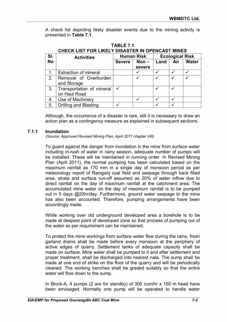
WBMDTC Ltd.
EIA/EMP for Proposed Gourangdih ABC Coal Mine 7-2
A check list depicting likely disaster events due to the mining activity is presented in Table 7.1.
TABLE 7.1
CHECK LIST FOR LIKELY DISASTER IN OPENCAST MINES
Sl. No
Activities Human Risk Ecological Risk
Severe Non – severe
Land Air Water
1. Extraction of mineral � � � �
2. Removal of Overburden and Storage
� � � �
3. Transportation of mineral on Haul Road
� � �
4. Use of Machinery � � �
5. Drilling and Blasting � � �
Although, the occurrence of a disaster is rare, still it is necessary to draw an
action plan as a contingency measure as explained in subsequent sections. 7.1.1 Inundation (Source: Approved Revised Mining Plan, April 2011 chapter VIII)
To guard against the danger from inundation in the mine from surface water
including in-rush of water in rainy season, adequate number of pumps will be installed. These will be maintained in running order. In Revised Mining Plan (April 2011), the normal pumping has been calculated based on the maximum rainfall as 170 mm in a single day of monsoon period as per meteorology report of Raniganj coal field and seepage through back filled area, strata and surface run-off assumed as 20% of water inflow due to direct rainfall on the day of maximum rainfall at the catchment area. The accumulated mine water on the day of maximum rainfall is to be pumped out in 5 days @20hr/day. Furthermore, ground water seepage to the mine has also been accounted. Therefore, pumping arrangements have been accordingly made.
While working over old underground developed area a borehole is to be
made at deepest point of developed zone so that process of pumping out of the water as per requirement can be maintained.
To protect the mine workings from surface water flow during the rains, fresh
garland drains shall be made before every monsoon at the periphery of active edges of quarry. Settlement tanks of adequate capacity shall be made on surface. Mine water shall be pumped to it and after settlement and proper treatment, shall be discharged into nearest nala. The sump shall be made at one end of strike on the floor of the quarry and will be periodically cleaned. The working benches shall be graded suitably so that the entire water will flow down to the sump.
In Block-A, 4 pumps (2 are for standby) of 300 cum/hr x 150 m head have
been envisaged. Normally one pump will be operated to handle water

WBMDTC Ltd.
EIA/EMP for Proposed Gourangdih ABC Coal Mine 7-3
seepage. In rainy season, more pumps will be operated as per requirement. While in case of Block-C, 6 pumps of 300 cum/hr x 250 m head have been envisaged. Two pumps will be operated in normal condition and upto five pumps may be operated in peak rainy season. To keep coal/OB face dry, 3 face pumps (1 for Blocks-A & C each and 1 for standby) of 50 cum/hr x 50 m head have been proposed. Besides main pumps and face pumps 3 numbers of slurry pumps has to be provided cleaning sumps.
7.1.2 Slope failure (a) Bench Failure The height, width and slopes of all the benches in overburden and coal will
be maintained as per scientific study being carried out by NIT Durgapur. A copy of the scientific study report shall be submitted to Directorate General of Mines Safety (DGMS) and all the precautions recommended in scientific study report will strictly be followed. Compliance to these measures will aid in obviating any risk of bench failures and subsequent accident hazard.
(b) Pit slope failure
As per approved Mining Plan, the proposed OC mine is planned for future
27 years period. The ultimate depth at the end of mining operation will be upto 120 m in Block-A and 210 m in Block-C. At the mine closure stage, the areas of both the quarries will be fully reclaimed. The RL of the top at this stage will be 150-160 m above MSL for both the quarries.
To prevent any wall failure in the mine, adequate bench width will be
provided in the mining system such that the overall working slope of the highwall remains within 25°. Overall slope of side batters shall always be within 45°. Coal benches has been planned with 80° from the horizontal and height will be usually 6 m.
As a part of the monitoring mechanism for safety of mine, a strict vigil is and
will be kept by reconnaissance surveys, especially in rainy season, to detect any impending danger so that the men and equipment can be accordingly moved out of danger area in time.
7.1.3 Disaster due to failure of waste dump There are two types of waste dumps, which are discussed below: i. Overburden Sliding of surface waste dump poses an equally severe risk compared with
quarry slope failure. Hence, it is imperative that the degree of hazard against potential failure of waste dump slope should be identified and that precautionary measures are to be adopted, if required.

WBMDTC Ltd.
EIA/EMP for Proposed Gourangdih ABC Coal Mine 7-4
In Block A which will be started first, the initial OB will be dumped over the already de-coaled area of Khoirabad Colliery. The height of the OB dump will be about 60 m above the original ground level. Block C will start dumping over the vacant space in the north of the quarry. The OB shall be dumped externally and internally. However, at the mine closure stage, the dumps will be regraded to ground level. The areas of both the quarries will be fully reclaimed.
The dumps will be stabilized by tree plantations and other arrangements as
detailed below:-
1. A garland drain will be constructed all around the waste dump area for smooth flow of water.
2. Drains and chutes will be made on the top and sides of waste dump, respectively, to arrest uncontrolled descent of water during rainy season. The water from the chutes will be collected in the garland drain at the bottom of the dump. This precaution is necessary to prevent erosion of waste dump due to erratic flow of rainwater.
3. A stone toe wall will be made all around the waste dump to prevent waste dump material from being carried out of the dump area and mixing with the general drainage system of the area. A clear space of 30 m width along the toe of the dumps will be maintained for safety.
4. The overall slope of dump will not be steeper than 28° to the horizontal.
5. For safety of dumpers, a wedge of sufficient height will be formed 10- 15 m away from the dump edges so that dumpers will dump before this wedge. The dumped material will be dozed by the dozer deployed there. This wedge will be maintained in every active dump edge during dumping operation.
6. Sufficient lights will be maintained at night for operation on active dump edges.
7. On the slope of the dump, small pits of 0.3 x 0.3 x 0.3 m will be cut and seedlings will be planted.On top of the benches, 1.5 m wide strip shall be planted along the edges.
ii. Backfill dump
Internal dumping for backfilling will be started from 5th year of mine
operation. The height of the internal backfill dump will go upto 60 m above ground level. It will be supported at the sides by quarry batters. However, the main advancing front of the backfill dump towards dip side will be amenable to slope failure especially during rainy season. The dumps will be properly compacted and planted as soon as ultimate height (surface level) is achieved. Water channels will be planned with intermediate, muck arresting pits so as to prevent any accumulation of water and erosion of dumps. The overall gradient of the dump shall not be more than 28°.

WBMDTC Ltd.
EIA/EMP for Proposed Gourangdih ABC Coal Mine 7-5
A systematic study will be commissioned to study the various slope stability parameters to reach at the optimum slope angle during mine operation period. Appropriate factor of safety will be adopted supported by sensitivity analysis of critical parameters. It is also proposed to monitor the backfill dump with latest geo-technical/ surface/ equipment e.g. Borehole extensometer, tape extensometer, EDM, Piezometers, Theodolites etc.. The monitoring will commence as a part of safety measures.
7.1.4 Haul Roads Haul roads would be well constructed (having berms where required) so
that machine movement is smooth and unobstructed. Norms have been fixed for construction and maintenance of haul roads.
Following measures will be taken to construct and maintain all the haul
roads:
1. Haul road for rear dumpers of 60T and ancillary equipment is proposed with double lane.
2. Shoulders on both sides of haul road shall be provided.
3. At corners and bends, there would be clear view for more than 30 m.
4. Gradient will be maintained at 1 in 16.
5. Where the road is above the surrounding level, a parapet wall embankment of at least one meter height would be provided.
6. A separate road for light vehicles will be maintained in the entire mine.
7. Haul roads will have drains on both sides.
8. Road side plantation on permanent haul roads is proposed.
Measures to prevent accidents due to trucks and dumpers
- All transportation within the main working would be carried out directly under the supervision and control of the management.
- The vehicles will be maintained in good repairs and checked thoroughly at least once a week by the competent person authorized for this purpose by the Management.
- Road signs will be provided at each and every turning point especially for the guidance of the drivers at the night.
- Men will not be allowed in areas where reversing of trackless vehicles at the embankment and tipping points is taking place. All areas for reversing of lorries would, as far as, possible be made man free.
WBMDTC Ltd.
EIA/EMP for Proposed Gourangdih ABC Coal Mine 7-6
- Statutory provision of the fences, constant education, training etc. will lead to reducing accidents.
- Haul trucks would be oriented essentially perpendicular to the bream, while unloading.
7.1.5 Accidents due to machineries / equipments Most of the accidents occur during transportation by dumpers and trucks.
The accidents due to other heavy vehicles are often attributable to mechanical failures, in which the human error factor cannot be ruled out. Mining machineries would be kept well maintained and in good running order. Regular monitoring of condition of equipment and its timely maintenance as per condition will be done. Wrong or careless operation of machines can also cause accidents, thus, only trained personnel shall be allowed to operate the machines. Unauthorised riding on moving vehicles should be prohibited and effectively enforced.
7.1.6 Disaster due to surface fire/ stack fires Sufficient fire extinguishers will be installed during operation at selected
locations on surface like Electrical Sub-stations, workshop, Garage, Diesel Depot, Stores etc. Besides, sufficient number of water hydrants with sufficient hose pipes will be made available on the surface for fire protection.
In order to prevent fire hazards in stockpiles, the following precautions will
be taken.
i) Prevent the occurrence or presence of any external source of fire in the vicinity of coal stockpiles i.e. naked fire, electric fire and fuel oil fire.
ii) In case there is need to operate electric equipment or store or use fuel
oil in the vicinity of the coal stock piles, appropriate types of fire extinguishers will be provided on or near such equipment in order to extinguish the fire at the very start.
iii) Restrict the stacking height of the coal to below two meters. Higher
height may only be attempted for shorter interval of stacking. The time and height shall be established with respect to spontaneous combustion which will help in restricting to safe parameters.
iv) Appropriate arrangement will be made by inserting pipes in the stack to
monitor the internal temperature of coal. In case, temperature is found to shoot above safe limits, the coal from that part of stack shall be immediately dug out and disposed safely.
v) In case, the insitu coal exposed in coal bench catches fire due to spontaneous heating, it will have to be kept under vigil. Under such

WBMDTC Ltd.
EIA/EMP for Proposed Gourangdih ABC Coal Mine 7-7
circumstances the affected area of coal shall be separately dug up and disposed off safely.
7.1.7 Accidents due to poor visibility
Where machines move, area would be well lighted either by general lighting
or by lights provided in the machines. Through circular no. DGMS (Legis.) Circular No. 02 of 2017 Dhanbad dated 06.11.2017, DGMS have prescribed norms for standards of illumination in opencast coal mines. The notification has been prescribed for guidance as well as for strict compliance of the same in all opencast coal mines. A lighting plan for the entire mine will be made and strictly implemented. In addition to this, mobile lighting arrangement will also be made to handle the situation during power failure.
In spite of providing good lighting, the visibility can be poor if dust is not
suppressed. Movement of dumpers is a major cause of making dust air borne and sprinkling of water on haul roads by mobile or permanent water sprinklers will be done to control dust.
7.1.8 Blasting
Fly rocks are a major source of accidents due to blasting. Ground vibrations
and air over pressure (air blast) are also at times dangerous for structures and building. They are also annoying for the neighbouring communities. The best practices available would be adopted and blasting will be conducted only as per DGMS circular No. 7 of 1997, which gives stipulations in this regard titled “Damage of structures due to blast induced ground vibrations in the mining area” to avoid any danger during operation of the mine.
In this project, controlled blasting techniques including muffled blasting will
have to be adopted within 500 m zone but beyond 100 m from the villages, dwelling, surface structures, roads etc.. Total quantity of explosive to be detonated at a time will be so regulated that ground vibration which may affect the nearby surface structures, are kept within the stipulated limit. The stipulated limits have been given in terms of permissible peak particle velocity (ppv) at the foundation level of structures in mining areas in mm/sec, and have been reproduced in Table 4.18 in chapter 4 earlier.
7.1.9 Explosion/ Storage of explosives in the magazine SMS explosives will be used for blasting. It is recommended to provide 2
numbers of magazines of 3 T capacity each for storage of high explosives, cast booster and explosive accessories.
The explosive magazine will be designed in such a manner that normal
chances of fire inside the magazine are ruled out. Still following precautions will be taken:
i. Clearance of dried vegetation within 15 m of Magazine House.

WBMDTC Ltd.
EIA/EMP for Proposed Gourangdih ABC Coal Mine 7-8
ii. Installation of lightening arresters on the Magazine will help safeguard against lightening damage and prevent subsequent explosion.
iii. Provision of fire extinguishers, water and sand filled buckets.
iv. Arrangement of mounds around the magazine to mitigate damage in the event of an explosion.
Keeping a safety zone around the Magazine as per the guidelines given in
Schedule VIII of The Explosives Rules, 1983. For a 3 T magazine of Category “ZZ”, the distance to process buildings should be minimum 106 m, to railway, road, etc. it should be minimum 142 m and to dwelling houses, offices, factories etc. should be minimum 283 m.
7.1.10 Drowning
Risk of drowing can be there where water bodies exist. Water bodies such
as mine sump and surface reservoirs will exist during operation while water in mine void will get collected at end of life of mine. Hence, surface water bodies at any stage of operation would be fenced off all around except at specially created ghats for public use or supervision with display boards/ warning signs. In this mine, after the end of mine i.e. during mine closure it is planned to rehandled the external OB and the crown dump of internal OB into the mine void, thus, levelling the quarry back to ground level. Hence, no water body shall remain.
7.1.11 Care and maintenance during temporary discontinuance Temporary discontinuance of the mine due to unforeseen circumstances
can occur. The following protective measures would be taken up to deal with the scenario arising due to same:
• All heavy earth moving machinery from the mine would be withdrawn and brought to a safe place. This will protect them against getting buried and damaged due to any benches collapse during the period of discountinuance.
• Security guards will be deployed to prevent stray animals or persons from entering into the mine.
• The entry to pit would be fenced. Notice board at the fences prohibiting entry of unauthorised persons will be put up.
• The fence will also prevent entry of cattle to the pit.
• At the entrance and strategic points, sentries/ watchmen will be posted to guard the mine area and Magazine. They will be provided with mobile phone/ walky-talkies to contact the mine authorities/ Police for help during emergency.
• The mine area will be kept illuminated during night time. Audible warning siren will be established at the mine office. It will for use during emergency so that prompt help can be received from proper sources.

WBMDTC Ltd.
EIA/EMP for Proposed Gourangdih ABC Coal Mine 7-9
• Managerial, supervisory and competent persons of the mine would be engaged for supervising machinery and house-keeping of the mine areas, as per needs.
7.2 DISASTER MANAGEMENT PLAN
In case a disaster takes place, despite preventive actions, disaster
management will have to be done in line with the description below. It is proposed to identify a dedicated group for dealing with emergency situations and for coordination among key personnel. The Group will comprise three teams, namely, Control team, Rescue team and Support team as shown in Fig 7.1.
The Group will be headed by an Emergency Coordinator (EC) who will be
the Mines Manager. In his absence, the senior most person available at the mine will act as Emergency Coordinator.
The proposed composition of the teams is given in Table 7.2.
TABLE 7.2 PROPOSED TEAMS TO DEAL WITH EMERGENCY SITUATION
Designation Qualification
A. Control Team
Leader/ Captain Mines Manager
Member Overman-I
Member Foreman
Member Mining Sirdar
B. Rescue Team
Leader/ Captain 1st Class Mines Manager
Member Safety Officer
Member Overman-II
Member Foreman
Member Mining Sirdar
FIG 7.1: ORGANISATION FOR DEALING WITH EMERGENCY SITUATION
EMERGENCY COORDINATOR MINES MANAGER
RESCUE TEAM
CONTROL TEAM
SUPPORT TEAM

WBMDTC Ltd.
EIA/EMP for Proposed Gourangdih ABC Coal Mine 7-10
Designation Qualification
C. Support Team
Leader/ Captain 1st Class Mines Manager
Member 2nd Class Mines Manager
Member Foreman
D. Security
A competent agency will be appointed for the security of various areas related to mining operations.
A tele-communication network and wireless will connect Site Emergency
Control Room (SECR) to control various Departments of the mine, fire station and neighbouring industrial units/ mines.
7.2.1 Roles and responsibilities of emergency team (a) Emergency Coordinator (EC)
The emergency coordinator will assume absolute control of site and will be located at SECR.
(b) Incident Controller (IC) Incident controller will be a person who will go to the scene of emergency
and supervise the action plan to overcome or contain the emergency. Shift supervisor or Environmental Manager will assume the charge of IC.
(c) Communication and advisory team
The advisory and communication teams shall consist of heads of various departments.
(d) Roll call coordinator
A senior person from administration or personnel department will be the Roll Call Coordinator. The Roll Call coordinator will conduct the roll call and will evacuate the mine personnel from assembly point. His prime function will be to account for all personnel on duty.
(e) Roll call leaders EC will appoint Roll Call leaders from maintenance/ store. The Roll Call
leaders will carry out roll call physically at roll call/ evacuation point. (f) Search and rescue team There will be a group of people trained and equipped to carry out rescue
operation of trapped personnel. The people trained in first aid and fire fighting will be included in search and rescue team.

WBMDTC Ltd.
EIA/EMP for Proposed Gourangdih ABC Coal Mine 7-11
(g) Emergency security controller An Emergency Security Controller will be senior most security person
located at main gate office and coordinating with the outside agencies e.g. fire brigade, police, DM, civil/ defence representatives and media men, etc.
(h) Shift medical officer He will be a doctor at the first aid centre/ medical centre of mine. (i) Personnel manager The personnel manager on arrival at site will handle all media men, contact
public and handle the visits by political/ statutory authorities. 7.2.2 Outside organisations involved in control of disaster
In the event of massive spillage of fuel oil or occurrence of fire, population
inside and outside mine boundaries, vegetation and animal etc. may be affected. In such circumstances, secondary fire may also take place. In such an event, help will be taken from outside agencies also.
The organisations that will be involved are as follows:
(a) State and local authorities: District Collector, Revenue Divisional Officer, etc.
(b) Chief Inspector of Explosives.
(c) Environmental agencies: Member Secretary of State Pollution Control Boards, Regional Officer of State Pollution Control Board.
(d) Fire Department: District Fire Officer.
(e) Police Department: District Superintendent of Police, SHOs of nearby Police Stations.
(f) Public Health Department:
- District Medical Officer.
- Residential medical officers of PHCs in a radius of 5 km around mine site.
(g) Local Community Resources:
- Regional Transport officer.
- Divisional Engineer Telephones.
(h) Director General of Mine Safety.
(g) Mines of ECL in surrounding area. The outside organisations will directly interact with District Magistrate, who
will consult and interact with EC to issue instructions on how to control the emergencies.

WBMDTC Ltd.
EIA/EMP for Proposed Gourangdih ABC Coal Mine 7-12
7.2.3 Emergency control procedure The onset of an emergency will in all probability, commence with a major
fire, explosion, inundation or collapse of face along excavation or failure of mine/ dump slope. These will be detected either by various safety devices and/or by members of staff on duty. If located by a staff member on duty, he (as per site emergency procedure of which he is adequately briefed) will go to nearest alarm call point, break glass and trigger off the alarms or immediately inform the site office through mobile phone or wireless, from where the alarm can be sounded. He will also try his best to inform the emergency control room about location and nature of accident. In accordance with work emergency procedure, the following key activities will immediately take place to control the emergency:
• Emergency Security Controller will commence his role from main gate office.
• Incident Controller will rush to the site of emergency and with the help of rescue team, will start handling the emergency.
• Site Main Controller will arrive at SECR with members of his advisory and communication team and will assume absolute control of the site. He will receive information continuously from incident controller and make decisions and give directions to:
� Incident controller
� Mine control rooms
� Emergency security controller
� Site or shift medical officer
• After all key emergency personnel have taken up positions, the incident Controller will use communication system to convey and receive the messages.
• At the site of incident, the incident controller will directly handle the emergency with the help of specific support group and fire fighting personnel etc.
• At the main gate Emergency Security Controller and Personnel Manager will contact external agencies.
• At the site medical centre/ first aid centre medical officer will take control of medical support services. Emergency Co-ordinator will be directing and deciding a wide range of emergency related issues. In particular, EC has to decide and direct.
- Whether incident controller requires reinforcement of manpower
and facilities?

WBMDTC Ltd.
EIA/EMP for Proposed Gourangdih ABC Coal Mine 7-13
- Whether mine is to be shut down or kept running?
- Whether staff in different locations is to remain indoors or to be evacuated and assembled at designated collection centre?
- Whether missing staff members are to be searched or rescued?
- Whether off-site emergency plan to be activated and a message to that effect is to be sent to district head quarter?
- Whether staffs in different locations are to remain indoor or are to be evacuated and assembled at designated collection centre?
- Whether missing staff members have been searched or rescued?
- Whether and when district emergency services are to be called?
- Respond to any large size complaints from outside public and to assess an off-site impact arising out of the on-site emergency?
• When the incident has eventually been brought under control, it will be declared by the Incident Controller. The EC will then send two members of his advisory team as inspectors to incident site for:
- An assessment of total damage and prevailing conditions with
particular attention to possibility of re-escalation of emergency which might, for the time being, be under control.
- Inspection of other parts of site, which might have been affected by impact of incident.
- Inspection of personnel collection and roll call centres to check if all persons on duty have been accounted for.
- Inspection of all control rooms of mine to assess and record the status of respective departments and any residual action deemed necessary.
• Post Emergency, the inspectors will return to SECR with their observations and report on findings and will submit the same to EC.
• Based on these reports, EC will communicate further directives to all emergency management sub-centres and will finally declare and communicate termination of emergency and authorise step by step restoration of normal operation of the affected mine areas. The fire siren will be sounded with all CLEAR – SIGNAL.
In all other type of emergencies like land slide etc, similar action will be
taken as in case of fire and explosion explained above.

WBMDTC Ltd.
EIA/EMP for Proposed Gourangdih ABC Coal Mine 7-14
During entire period of emergency, the site will remain out of bounds to external visitors except.
- District Fire Personnel
- District hospital ambulance staff
- Civil/ defence personnel
- District administration
- Factory inspectorate and Labour Commissioner
- Officers of State Pollution Control Board
- Insurance authorities
- Directorate General of Mine Safety
- Chief Inspector of Explosives
All the members of public, political parties, gram panchayat, etc. will be
dealt with from the main gate office by the Emergency Security Controller and the Personnel Manager.
7.2.4 Alarm system to be followed during disaster
On receiving the message of disaster, from Site Main Controller, fire station
control room attendant will sound SIREN I WAILING TYPE FOR 5 MINUTES. Incident controller will arrange to broadcast disaster message through public address system.
On receiving the message of "Emergency Over" from Incident Controller the
emergency control room attendant will give "All Clear Signal”, by sounding alarm straight for two minutes. The features of alarm system will be explained to one and all to avoid panic or misunderstanding during disaster.
7.2.5 Actions to be taken on hearing the warning signal
On receiving the disaster message following actions will be taken
- All the members of Advisory Committee, Personnel Manager, Security Controller, etc. shall reach the SECR.
- The persons of various Departments of mine production will remain ready in their respective units for crash shutdown of mining activities on the instruction from SECR.
- The persons from other sections will report to their respective officers.
- The concerned section will take immediate action to remove contractor's personnel outside the mine gate.
- Residents of surrounding villages will remain alert.

WBMDTC Ltd.
EIA/EMP for Proposed Gourangdih ABC Coal Mine 7-15
7.3 SUMMARY OF THE PROCEEDING OF PUBLIC CONSULTATION
Public hearing for the proposed mine was held on 20.09.2018 at 12:00 hrs at the “Agniveena Hall” at the office campus of Barabani Block Office, Dist-Paschim Bardhaman, West Bengal under the Chairmanship of Sri Prasanta Mandal, WBCS (Exe.) Additional District Magistrate, Paschim Bardhaman with Sri Surojit Ghosh, WBCS (Exe.), Block Development Officer, Barabani Block, Sri Shouvik Ganguly, Assistant Environment Engineer, West Bengal State Pollution Control Board on the basis of the prepared draft EIA report, which included the Terms of References prescribed by the Ministry of Environment, Forest & Climate Change. Sri Gourab Poddar. Executive Director of WBMDTCL welcomed the gathering on his company’s behalf and gave a brief introduction of the proposed project. He further assured that the proposed project will lead to overall socio-economic development of the neighbouring area. Representatives of various villages, people’s representatives and officers of M/s West Bengal Mineral Development & Trading Corporation Ltd. (WBMDTCL) were also present.
Various points were raised by the local people during the public hearing.
The same were recorded by the WBPCB and the points requiring action from the Company have been addressed and their execution outlined in Table 7.7. The summary of the proceedings of the public consultation and
the actions taken or to be taken by the company are covered in this section. The notice for public hearing was published in daily English newspaper “The
Times of India” and “Ei Samay” on 18.08.2018. 129 persons signed the attendance sheet and 10 people raised questions/ doubts/ comments/ suggestions during Public Hearing. Public hearing documents including notice published in newspaper, English translation of Minutes of Meeting, etc. are given in Annexure XXVII.
During public hearing, the people welcomed the project but raised few
points related to proposed pollution and mitigative measures, R&R package, impact on ground water, employment opportunity etc. Sri Gourab Poddar. Executive Director of WBMDTCL assured the audience that being a government organization they will ensure that during project activities all statutory norms regarding mine safety and pollution control are strictly complied with. Questions/ doubts/ comments/ suggestions raised during public hearing and replies by the project proponent as per the latest activities undertaken/ proposed to address them has been given in Table 7.3.

WBMDTC Ltd.
EIA/EMP for Proposed Gourangdih ABC Coal Mine 7-16
TABLE 7.3 STATEMENT OF MAIN ISSUES RAISED BY THE PUBLIC AND RESPONSE OF
THE PROJECT PROPONENT WITH ACTION PLAN
Sl. No.
Name & Address of villager
Question/ Issue/ Suggestion
Response by project proponent
(after PH)
Action Plan proposed Budgetary provision as on
31-12-2018
1. Sri Anup Kumar Roy
Vill-Panuria,
Barabani Block, Paschim Bardhman
He wanted to know about the probable air pollution caused during mining operation and the mitigative measure to be taken by the Project Proponent (PP) for minimizing the same.
Air pollution during mining will be due to excavation, transportation, handling, loading and hauling operation. Dust generation due to mining operation occurs within the mine pit, from haul roads as well as dumping areas. At the same time, gaseous pollutants like hydrocarbons, NO2, CO, CO2, SO2, etc. are also generated from the vehicle exhaust, due to blasting and spontaneous heating in coal stock.
Mitigative measures to reduce dust emission will be adopted such as water spraying. Other measures include control blasting techniques will be followed. Maintenance of HEMM, transport vehicles, wetting of the coal/ OB prior to loading, avoiding overloading of dumpers, plantation in peripheral greenbelt (7.5m), in safety zone between village and quarry (45 m), along the sides of haul roads (outside quarry area or working dumps) and other vacant areas etc.
Company will follow the mitigation measures as detailed in Chapter 4 of EIA/EMP Report to minimise air pollution.
Execution plan
On commencement of construction of Infrastructure facilities & operation of mine and will continue till the end of the life of mine operation.
The EMP cost has been worked out in detail in Table 6.2 (capital cost) and Table 6.3 (recurring cost) of Chapter 6.
Capital Cost - Rs. 17.27 crores & recurring cost - Rs. 6.35 crores/ annum

WBMDTC Ltd.
EIA/EMP for Proposed Gourangdih ABC Coal Mine 7-17
Sl. No.
Name & Address of villager
Question/ Issue/ Suggestion
Response by project proponent
(after PH)
Action Plan proposed Budgetary provision as on
31-12-2018
2. Sri Byomkesh Bhandari
Vill-Panuria,
Barabani Block, Paschim Bardhman
He requested PP to elaborate about the proposed relocation and rehabilitation (R&R) package to be offered to the villagers of Gourangdih B area which is excluded from the scope of the proposed project.
Since Gourangdih B area will not be mined, the inhabitants and land owners within the boundary of Gourangdih B will not be disturbed in any way. A 45 m wide buffer will be maintained between quarry and the settlement in Gourangdih B so that indirect impacts are also not there. Hence, there is no proposal for relocation or rehabilitation (R&R) for villagers of Gourangdih B area.
Nil
Execution plan
Buffer zone between quarry and Gourangdih B will be maintained from beginning till the end of project life.
Cost of plantation @1.0 lakhs/ ha
3. Sri Dilip Kumar Sharma
Vill-Panuria,
Barabani Block, Paschim Bardhman
He enquired about the probable impact of the proposed project on the ground water level of the locality
What precaution the PP will take to ensure that there is no detrimental effect of proposed mining activity on the local underground water table.
Mine seepage is anticipated as the mine workings will go below the water table. The maximum mine seepage is anticipated as 10,120 cum/day in tenth year. The radius of influence has been identified as 160 m. The mine seepage water be collected in the mine sump, pumped to surface reservoir and will be utilized for mine activities, plantation, etc. after settlement of suspended solids. The excess water can be utilised for agriculture by nearby farmers or released to the natural drain after settlement of solids.
The mine seepage will have a radius of influence within which decline of water table will be experienced.
For the areas within the radius of influence, company is committed to ensure potable water supply in the villages through construction and maintenance of deep tubewells or construction of over head tanks with piped water supply. Peizometers shall be installed and water level and quality will be checked regularly.
Execution plan
On commencement of operation of mine and will continue till the end of life of mine operation
The EMP costing has been worked out in detail in Table 6.2 (capital cost) and Table 6.3 (recurring cost) of Chapter 6.
Capital Cost - Rs. 20.0 lakhs for installation of 4 numbers of Peizometer.
The cost of deep tubewell construction will be approx. Rs. 25 lakhs

WBMDTC Ltd.
EIA/EMP for Proposed Gourangdih ABC Coal Mine 7-18
Sl. No.
Name & Address of villager
Question/ Issue/ Suggestion
Response by project proponent
(after PH)
Action Plan proposed Budgetary provision as on
31-12-2018
4. Sri Rameswar Hansda
Vill-Digalpahari
I) He wanted to know about the overall environmental impact of the proposed project on the neighbouring area and the probable mitigative measures in this regard to be taken by the PP.
As mine will be worked by opencast method there shall be impact in environment as detailed in Chapter 4 of EIA Report. Executive Director of WBMDTCL assured the audience that being a government organization they will ensure that during project activities all statutory norms regarding mine safety and pollution control are strictly complied with.
Company will follow the mitigation measures as detailed in Chapter 4 of EIA/EMP Report.
Execution plan
On commencement of construction of Infrastructure facilities & operation of mine and will continue till the end of the life of mine operation
The EMP costing has been detailed in Table 6.2 (capital cost) and Table 6.3 (recurring cost) of Chapter 6.
Capital Cost - Rs. 17.27 crores & recurring cost - Rs. 6.35 crores/ annum
ii) He further requested the PP to elaborate about the R & R package to be offered to the residents of the villages which are just beyond the project area but will be directly be affected during mining activities.
The project falls under seven villages which are Shibdhara, Bandhaura, Lalbandh in Block-A and part of Panuriya, Kantapahari, Gourangdih & Bhuiapara in Block-C. Total 629 houses and various PAFs under different categories have been identified in total project area. An R&R plan has been prepared and will be implemented for the project affected people in consultation with the local administration and public representatives. The people beyond the project will be protected from indirect impacts by creation of 45 m buffer zone between Quarry and settlement in Gourangdih-B area. The persons outside the project area are not covered under the purview of R&R plan
A committee will be constituted at project level under the chairmanship of the District Magistrate or authorized representative and WBMDTC Ltd. to be called the “Rehabilitation and Resettlement Committee”. The committee shall endeavour to monitor and review the implementation progress of the Rehabilitation and Resettlement scheme for Project Affected Persons and to carry out post implementation social audits in consultation with village panchayat. The Rehabilitation and Resettlement Plan will be monitored and evaluated periodically after completion of the land
R&R package is expected to be in the range of Rs. 91.81 Crores (PAF Opt for employment) to 105.95 Crores (in case PAF not opt for employment). This package includes the costs due to R & R of the PAFs, excluding the compensation for the land.

WBMDTC Ltd.
EIA/EMP for Proposed Gourangdih ABC Coal Mine 7-19
Sl. No.
Name & Address of villager
Question/ Issue/ Suggestion
Response by project proponent
(after PH)
Action Plan proposed Budgetary provision as on
31-12-2018
acquisition process.
Execution plan
On commencement of land acquisition for the project till the completion of land acquisition for the project.
5. Sri Jagannath Mondal
Vill-Panuria,
Barabani Block, Paschim Bardhman
He requested the PP to inform about the probable impacts of blasting operation during mining on the neighboring villages and protective measures to be taken in this regard.
Flying fragments due to blasting or vibration and secondary minor cracking of structures on the surface may occur in nearby villages if precaustions are not taken. However, in our case, controlled blasting techniques including muffled blasting will be adopted to avoid tension cracks and back breaks. The DGMS norms for peak particle velocity and minimum safety distance shall be maintained
Permission from the DGMS shall be obtained prior to blasting. Fencing, protection, regeneration & maintenance of Safety Zone shall be there
Execution plan
Start - During operation, Before commencement of blasting till the blasting is required.
Capital Cost - Rs. 10 lakhs & recurring cost - Rs. 5.37 lakhs/ annum
He requested PP to take necessary action on poor road conditions and traffic nuisance in the neighboring mining areas due to frequent movement of heavy vehicles and improve the prevailing situation.
The company commits that the trucks leaving the mine lease shall be optimally loaded and over loading will be prohibited. The transportation vehicles will undergo for “Pollution Under Control (PUC)” checkups every six months.
Company will undertake road maintenance activities, where permitted.
Company would initially target the villages within 2 km of Gourangdih ABC coal mine.
Construction of a new road from tribal basti at Kashidanga to Jamgram (1 km) and Aliganja village to Panuriya (1.5 km) is proposed.
Maintenance of roads, where required in phase manner in collaboration with local
Capital Cost - Rs. 35 lakhs & recurring cost - Rs. 10 lakhs/ annum

WBMDTC Ltd.
EIA/EMP for Proposed Gourangdih ABC Coal Mine 7-20
Sl. No.
Name & Address of villager
Question/ Issue/ Suggestion
Response by project proponent
(after PH)
Action Plan proposed Budgetary provision as on
31-12-2018
Panchayat and Govt. Schemes shall be done.
Execution plan
Roads shall be maintained from commencement of construction and operation of project and will continue till the end of life of mine.
6. Sri Shyama Maji
Vill – Shibdhawara
Barabani Block, Paschim Bardhman
He wanted to know about the compensation package including jobs to be offered to the farmers who will lose their agricultural land in the project area.
The benefits determined under rehabilitation scheme will comprise of land compensation (for land procured and associated solatium and other compensations, if any), employment provision (one job for every 2 acres of land) or lump sum payment of Rs. 10 lakhs in lieu of employment.
As per R&R plan
Execution plan
On commencement of land acquisition for the project till the completion of land acquisition for the project.
Same as point 4 (ii) above
7. Shri Sonaram Soren
Vill – Shibdhawara
Barabani Block, Paschim Bardhman
He informed the gathering that the local tribal villages will be seriously affected by the proposed project.
Total 629 houses and various numbers of PAFs under different categories including SC and ST Population have been identified in total project area. Population of these houses and various PAFs will be shifted and resettled. For this, detailed R&R plan has been made by WBMDTC Ltd and the same is under process for approval.
These PAFs shall be benefited as per R&R policy.
Execution plan
On commencement of land acquisition for the project till the end of entire land acquisition.
As per R&R Plan of WBMDTC Ltd.

WBMDTC Ltd.
EIA/EMP for Proposed Gourangdih ABC Coal Mine 7-21
Sl. No.
Name & Address of villager
Question/ Issue/ Suggestion
Response by project proponent
(after PH)
Action Plan proposed Budgetary provision as on
31-12-2018
He emphasized that the local tribal villagers should be offered proper R&R package before the project activity is started.
As per provision of R&R plan, in the case of land being acquired from the SC and/ or the ST, at least one-third of the compensation amount due shall be paid to the affected families initially as first instalment and the rest shall be paid after taking over the possession of the land.
As per R&R plan
Execution plan
On commencement of land acquisition for the project till the completion of land acquisition for the project.
As per R&R Plan of WBMDTC Ltd.
8. Sri Ujjal Bauri
Vill - Kashidanga
Barabani Block, Paschim Bardhman
He wanted to know the probable impact of project activities on their village which is located at a distance of about one hundred meters from the project site.
The impacts of the project will be felt in terms of increase in fugitive dust from dumping activities. For this, the company will be undertaking rigorous sprinkling, geo-stabilisation of dump slope and plantation to minimise the magnitude and duration of impact. Another likely impact will be in decline of water table for which deep borewell with water supply system is porposed,
Dump management and dust suppression measures will be implemented. Deep tubewells with water supply system are proposed.
Execution plan
Start - On commencement of operation till end of life of mine.
The expenditures will as per Table 6.2 (capital cost) and Table 6.3 (recurring cost) of Chapter 6.
9. Shri Bablu Ruidas
Vill-Panuria,
Barabani Block, Paschim Bardhman
He requested the PP to ensure proper R&R package for land losers and affected people.
The company is committed to follow the R&R plan
The provisions of R&R plan shall be followed.
R&R package is expected to be in the range of Rs. 91.81 Crores (PAF Opt for employment) to 105.95 Crores (in case PAF not opt for employment).
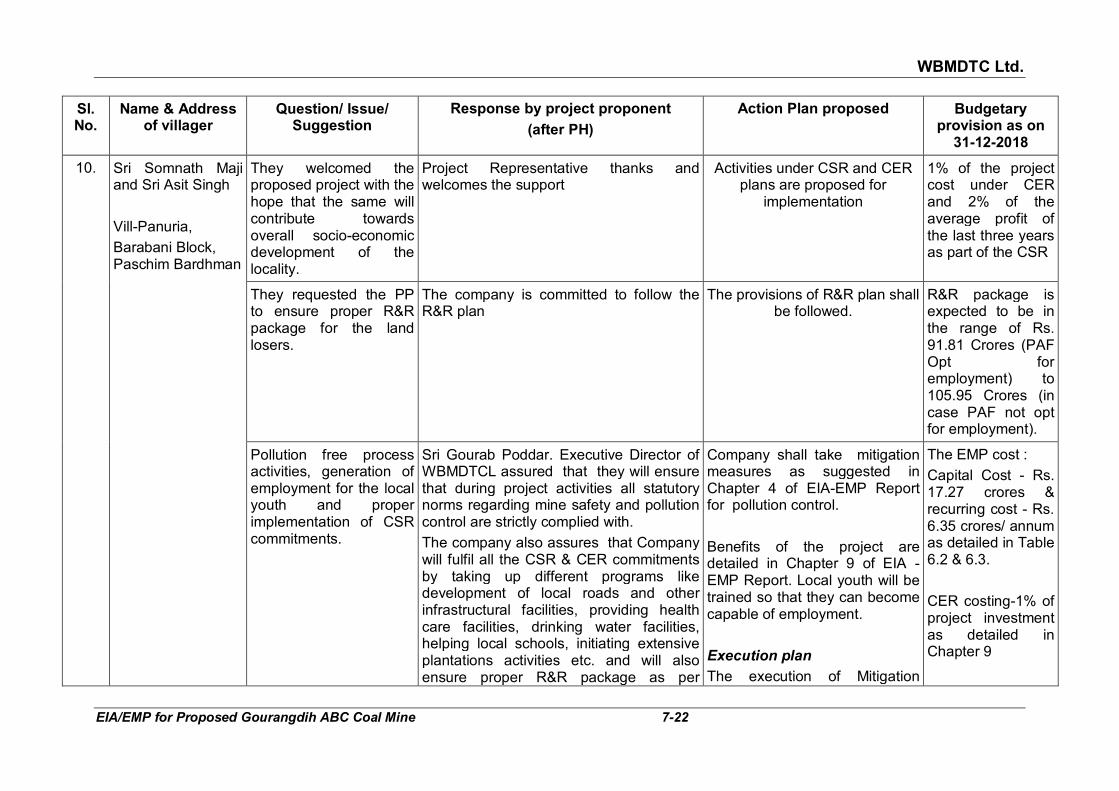
WBMDTC Ltd.
EIA/EMP for Proposed Gourangdih ABC Coal Mine 7-22
Sl. No.
Name & Address of villager
Question/ Issue/ Suggestion
Response by project proponent
(after PH)
Action Plan proposed Budgetary provision as on
31-12-2018
10. Sri Somnath Maji and Sri Asit Singh
Vill-Panuria,
Barabani Block, Paschim Bardhman
They welcomed the proposed project with the hope that the same will contribute towards overall socio-economic development of the locality.
Project Representative thanks and welcomes the support
Activities under CSR and CER plans are proposed for
implementation
1% of the project cost under CER and 2% of the average profit of the last three years as part of the CSR
They requested the PP to ensure proper R&R package for the land losers.
The company is committed to follow the R&R plan
The provisions of R&R plan shall be followed.
R&R package is expected to be in the range of Rs. 91.81 Crores (PAF Opt for employment) to 105.95 Crores (in case PAF not opt for employment).
Pollution free process activities, generation of employment for the local youth and proper implementation of CSR commitments.
Sri Gourab Poddar. Executive Director of WBMDTCL assured that they will ensure that during project activities all statutory norms regarding mine safety and pollution control are strictly complied with.
The company also assures that Company will fulfil all the CSR & CER commitments by taking up different programs like development of local roads and other infrastructural facilities, providing health care facilities, drinking water facilities, helping local schools, initiating extensive plantations activities etc. and will also ensure proper R&R package as per
Company shall take mitigation measures as suggested in Chapter 4 of EIA-EMP Report for pollution control.
Benefits of the project are detailed in Chapter 9 of EIA -EMP Report. Local youth will be trained so that they can become capable of employment.
Execution plan
The execution of Mitigation
The EMP cost :
Capital Cost - Rs. 17.27 crores & recurring cost - Rs. 6.35 crores/ annum as detailed in Table 6.2 & 6.3.
CER costing-1% of project investment as detailed in Chapter 9

WBMDTC Ltd.
EIA/EMP for Proposed Gourangdih ABC Coal Mine 7-23
Sl. No.
Name & Address of villager
Question/ Issue/ Suggestion
Response by project proponent
(after PH)
Action Plan proposed Budgetary provision as on
31-12-2018
prevailing norms in consultation with the local administration and public representative.
The appointed MDO will be instructed by WBMDTCL to give priority to local people in employment in their proposed project as per their capability and eligibility.
measures and CSR activities will start from the commencement of project and will continue till end of life of mine.

WBMDTC Ltd.
EIA/EMP for Proposed Gourangdih ABC Coal Mine 8-1
CHAPTER 8
MINE CLOSURE PLAN The format of this chapter is as per the guidelines of Ministry of Coal for
preparation of Mine Closure Plan. The data in this chapter has been mostly sourced from the approved Min Closure Plan, May 2011.
8.1 INTRODUCTION WBMTDCL has been allotted the Gourangdih ABC Coal Mine by Ministry of
Coal for supply of coal to industries through commercial sale. It was a mine operational since long prior to allotment.
Gourangdih ABC Coal Block lies in the north central part of Raniganj
Coalfield, Paschim Bardhaman District in West Bengal and is proposed to produce coal at the rate of 2.5 MTPA by opencast operation. In view of the surface constraints of built up areas, Gourangdih ABC block has been considered in 3 sub blocks namely, Gourangdih A, Gourangdih B and Gourangdih C. The same can be seen in Fig 1.1 in Chapter 1 of this report.
The required mining lease is 213.27 ha. The area required outside lease is
143.305 ha. Thus, total project area will be 356.575 ha. Presently project area has fallow (44.07 ha), agricultural (48.43 ha), degraded land (Old Quarry 61.316 ha), built-up area (60.86 ha), water body (15.44 ha), Forest (109.459 ha) & non agricultural land (17 ha for colony & rehabilitation). The mining is proposed by opencast method using conventional mining equipment of shovel and dumper combination. Coal is to be used for supply to industries across various states and overall ROM Grade of coal is Non Coking Coal. Since it is C to G Grade, no coal washing is envisaged. The method of mining has already been described in detail in Chapter 2.
8.1.1 Reasons for closure
Reasons for Mine Closure can be exhaustion of mineable coal reserves,
lack of demand, uneconomic operations, natural calamity or directives from a statutory organization.
8.1.2 Statutory obligations
It is a new block allotted to M/s WBMDTC Ltd. from Ministry of Coal vide
order F. No. 103/6/2016/NA dated 29th September, 2016. Mine was earlier allotted to Gourangdih Coal Ltd. (A Joint Venture of HEPL and JSW Steel Ltd.) and accordingly Mine plan and Mine closure plan was prepared and approved. The Revised Mining Plan and Mine Closure Plan was approved by Ministry of Coal on 28.06.2011 and the same has been transferred to and will be followed by new allottee. Hence, there are no statutory

WBMDTC Ltd.
EIA/EMP for Proposed Gourangdih ABC Coal Mine 8-2
obligations imposed by any authority except that there is one allotment letter from the Ministry of Coal. The conditions stipulated in the allotment letter shall be strictly complied to.
Other obligations: Other obligations will be there as a result of the following approvals:
i. Environmental clearance letter from MoEF&CC
ii. Forestry clearance letter from Forest Deptt, MoEF&CC
iii. Consent to Operate and Consent to Establish certificate from State Pollution Control Board
iv. Prior mine opening permission under Colliery Control Rules, 2004 from Coal Controller
v. Permission from Directorate General of Mine Safety
vi. Permission from Chief Controller of Explosives All the obligations spelt out in the above letters/ clearances and any other
letters which will be issued, will be complied to by the Company. 8.2 MINE DESCRIPTION Mine description comprises geology, reserves, quality of coal, details of
exploration, mining method, mineral beneficiation and coal handling etc. These are already covered under Chapter 2 of this report in detail.
8.3 MINE CLOSURE PLAN 8.3.1 Mined out land This is a opencast coal mining project. Hence, land degradation will be one
of the major adverse outcomes of the mining activities. The first step in a successful reclamation plan is to decide the post mine closure stage land use. The land use, during-mining (end of mining 27th year) and post mining (30th year) with environment management is given in Table 8.1.
TABLE 8.1
POST CLOSURE LAND USE (HA)
Land use during
mining ↓
Post Closure Land Use (ha) ↓
Plantation Agricult
ure
Agro-
forestry
Water
Body
Public
Use
Un-
disturbed
Total
External OB Dump 0.19 51.88 10.9 62.97
Top soil Dump 13.73 13.73
Excavation 213.27 213.27

WBMDTC Ltd.
EIA/EMP for Proposed Gourangdih ABC Coal Mine 8-3
Land use during
mining ↓
Post Closure Land Use (ha) ↓
Plantation Agricult
ure
Agro-
forestry
Water
Body
Public
Use
Un-
disturbed
Total
Roads 4 4 8
Built up area 10.23 17 27.23
Green Belt 7.52 7.52
Undisturbed Area 23.85 23.85
31.56 65.61 238.4 0 21 0 356.57
Land Situation at Mine Closure: At the mine closure stage, the excavated area of both the quarries namely
Block–A and Block–C will be fully backfilled & reclaimed and they will be levelled to surrounding ground levels. Top soil remaining in the soft OB external dump during mining operations will be spread over these two backfilled quarries. The RL of the top of filled up areas will be 150-160 m above MSL in Block–A and in Block–C. In addition to the backfilled quarry, the areas under external soft and hard OB dumps will also be reclaimed. The reclaimed areas will be used for agriculture, plantation and agro-forestry. The year wise reclamation programme has already been given in Table 4.14 of Chapter 4. The post mine land use plan is given in Fig 8.1
subsequently. 8.3.2 Water quality management The base line data of water is given in Section 3.7.3 of Chapter 3. The water
quality management proposed is given in Section 4.5.3 of Chapter 4 of this report.
8.3.3 Air quality management The air quality status of study area is detailed in Section 3.5 of Chapter 3.
The air quality management proposed is given in Section 4.4 of Chapter 4 of this report.
8.3.4 Waste and OB management No rejects will be generated from the coal. The major waste material will be
hard and soft overburden. Hard overburden will not be utilisable for any gainful purpose, hence, it is proposed to be disposed of into surface dumps and backfill dumps. The utilisation of top soil (soft overburden) is given in next section.
Waste management in this mine has been described in Section 4.7.2 and
4.7.3 of Chapter 4.

WBMDTC Ltd.
EIA/EMP for Proposed Gourangdih ABC Coal Mine 8-4
FIG 8.1: FINAL MINE CLOSURE PLAN

WBMDTC Ltd.
EIA/EMP for Proposed Gourangdih ABC Coal Mine 8-5
8.3.5 Top soil management The total topsoil generated will be 3.19 Mcum (B) during the life of the mine.
The top soil generated will be stacked separately and will be spread over the reclaimed dump concurrent with mining. Top soil will be stored in separate external dump during mining operations and will be spread over the two backfilled quarries and levelled to match with the original ground level around the quarries. Soil conservation measures have been discussed in Section 4.7.3 of Chapter 4 of this report earlier.
8.3.6 Infrastructure Complete site facilities are important for such mines. It is imperative to
develop core infrastructure like power, road, telecommunication, residential facility, diesel storage, explosive magazine and service buildings such as office, store, rest house, first aid centre, canteen, etc. Colony has been envisaged for 494 employees.
At the mine closure stage, out of the total 27.23 ha under built up area, it is
planned to dismantle and utilise 10.23 ha for agro-forestry and balance 17 ha shall be released for public use.
8.3.7 Disposal of mining machinery Machinery belonging to the company will be either shifted to other working
mines or disposed off as scrap. No machinery will be left within the ML area after the mine is abandoned.
8.3.8 Safety and security The life of the OC mine operations is 27 years. During mining operations
some of the safety precautions that will be implemented are as under:
i. Plantation and mine fencings shall be protected by security persons.
ii. Garland drains shall be kept clean prior to and during rainy seasons. Such cleaning work shall be continued in post mine closure too till final dump consolidates and vegetation becomes self sustaining.
iii. Provision of Coal Mine Regulations/ Rules/ circulars of DGMS would be strictly followed.
iv. Safety training will be imparted to the employees for protection against land slide/ fall, moving equipment’s, during blasting operation, accidental fire or electric shock etc.
8.3.9 Disaster management The disaster management plan is given in Chapter 7 of the EIA/EMP report.

WBMDTC Ltd.
EIA/EMP for Proposed Gourangdih ABC Coal Mine 8-6
8.3.10 Temporary discontinuance The life of the mine is 27 years. In case of any temporary discontinuance
due to any enforcing circumstances or court order etc., the mine shall remain under the charge of mines manager with specific supporting staff and equipment to take care of provision of rules and regulations applicable thereupon. Notices of temporary closure shall be served to respective department and concerned authorities. In case of reopening, the procedure led by Director General of Mines Safety shall be strictly complied and the notices for reopening shall be sent to all respective departments and concerned authorities. Security guards will be deployed to prevent stray animals or persons entering the mine. Temporary fencing with notices will be put up.
8.4 ECONOMIC REPERCUSSIONS OF CLOSURE OF MINE AND
MANPOWER RETRENCHMENT
Mine Closure always has environmental, social and economic impacts
associated with it. While the environmental aspect is largely addressed, the socio-economic aspects also need to the addressed.
During the life of the mine, the communities in the surrounding villages
come to depend on the same for some of their economic activities due to development of small businesses linked to the mine and its employees.
The closure of the mine brings about not only loss of jobs for the direct
employees but also affects the livelihood of those who have come to depend upon it indirectly. We, thus, have two classes of affected people. Their management as proposed in Chapter 5 of the approved Mine Closure Plan is as follows:
(i) The direct employees shall be offered jobs at alternate sites of the
organization and those willing to relocate shall be transferred there. Skill up-gradation training would also be imparted to such willing employees to make them suitable for alternate jobs where required.
For those, who due to their advanced age or other constraint, cannot
relocate to alternate site or alternate employment, the company will explore the possibility of offering them an opportunity to opt for voluntary retirement with commensurate benefits. The provision apart from financial settlement may also include retention of the company house provided during the employment.
(ii) The indirectly affected persons would also be rehabilitated by offering
them alternate means of livelihood by undertaking plantation and cultivation in the reclaimed land, poultry etc. Mine closure is an inevitability and it is intended that by the time the closure occurs, the community will be made self sustainable. The Company shall provide following facilities to the affected persons:
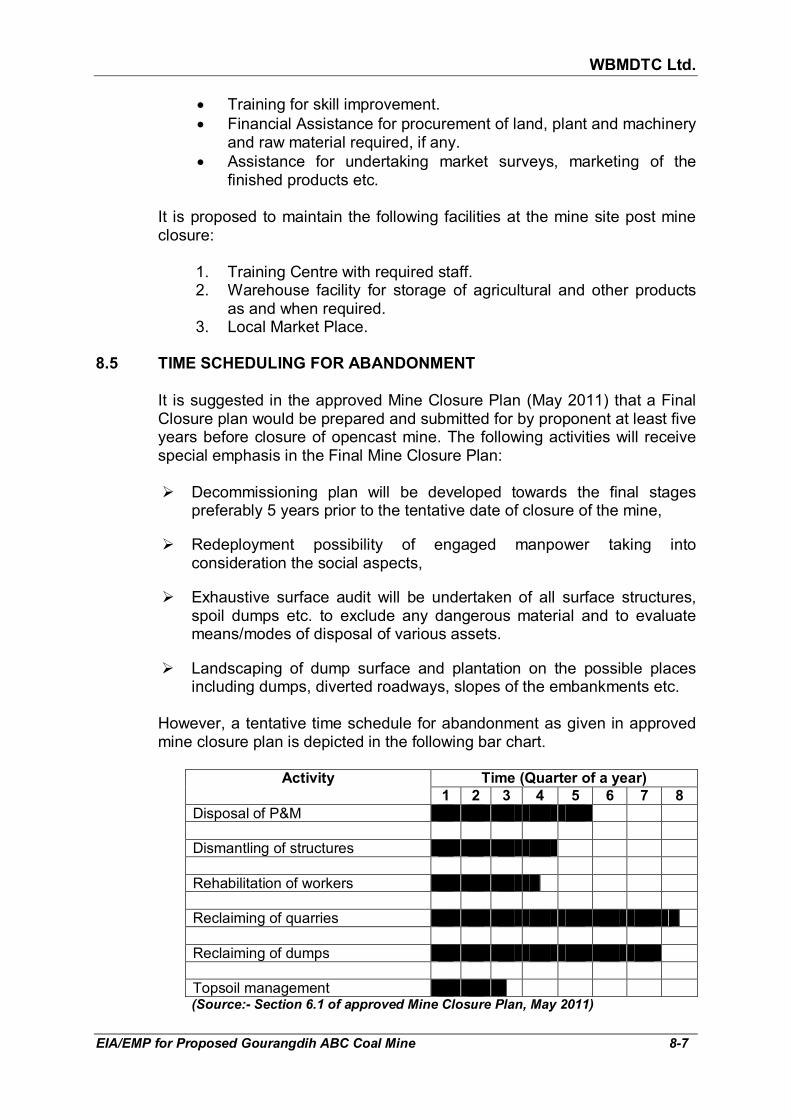
WBMDTC Ltd.
EIA/EMP for Proposed Gourangdih ABC Coal Mine 8-7
• Training for skill improvement.
• Financial Assistance for procurement of land, plant and machinery and raw material required, if any.
• Assistance for undertaking market surveys, marketing of the finished products etc.
It is proposed to maintain the following facilities at the mine site post mine
closure:
1. Training Centre with required staff. 2. Warehouse facility for storage of agricultural and other products
as and when required. 3. Local Market Place.
8.5 TIME SCHEDULING FOR ABANDONMENT
It is suggested in the approved Mine Closure Plan (May 2011) that a Final
Closure plan would be prepared and submitted for by proponent at least five years before closure of opencast mine. The following activities will receive special emphasis in the Final Mine Closure Plan:
� Decommissioning plan will be developed towards the final stages
preferably 5 years prior to the tentative date of closure of the mine,
� Redeployment possibility of engaged manpower taking into consideration the social aspects,
� Exhaustive surface audit will be undertaken of all surface structures, spoil dumps etc. to exclude any dangerous material and to evaluate means/modes of disposal of various assets.
� Landscaping of dump surface and plantation on the possible places including dumps, diverted roadways, slopes of the embankments etc.
However, a tentative time schedule for abandonment as given in approved
mine closure plan is depicted in the following bar chart.
Activity Time (Quarter of a year)
1 2 3 4 5 6 7 8
Disposal of P&M
Dismantling of structures
Rehabilitation of workers
Reclaiming of quarries
Reclaiming of dumps
Topsoil management (Source:- Section 6.1 of approved Mine Closure Plan, May 2011)

WBMDTC Ltd.
EIA/EMP for Proposed Gourangdih ABC Coal Mine 8-8
Facilities to be dismantled and to be retained All electrical/ mechanical/ structural items of infrastructure established for
use in mining activities would be removed for gainful use at other sites of the mining company. Only the non-usable machines and scraps will be auctioned.
a. It is proposed to dismantle the following facilities:
� Coal Handling Plant along with all conveyors and storage bunkers
� Workshop
� Store house
� Pump house
� Canteen
� Office buildings b. The following facilities shall not be dismantled:
� Colony Buildings
� Water pipelines
� Water tanks
� Overhead electrical transmission lines established for supply of power to these facilities
� Roads constructed to serve these facilities (balance can be dismantled)
� Dispensary The above facility shall be handed over to the concerned State Authority, on
closure of the mine for best possible use by the local community. As the company shall hand over these facilities to the State Government, the maintenance shall also be done by the State Government thereafter.
8.6 ABANDONMENT COST
A. Activities and cost Tentative cost estimate has been done for mine closure on approximate
basis. The exact amount will depend on the price index at the actual period of Final Mine Closure and on any directives issued by various Central/ State Government agencies for implementation at that stage. Expenditure for mine closure activities are given in Table 8.2 below:

WBMDTC Ltd.
EIA/EMP for Proposed Gourangdih ABC Coal Mine 8-9
TABLE 8.2 EXPENDITURE FOR MINE CLOSURE ACTIVITIES
Sl. No.
Description of Activity Cost
(Rs. Lakh)
1. Barbed wire fencing all around the area 10
2. Dismantling/ demolition of structures 10
3. Cleaning of site 10
4. Rehabilitation/ relocation of mining machinery 100
5. Plantation 400
6. Biological reclamation of left out OB dump 200
7. Filing up of de-coaled void
Biological reclamation of de-coaled void
2000
150
8. Post closure environmental monitoring for 3 years 15
9. Supervision charges for three years 90
10. Power cost 15
11. Protective and rehabilitation measures including maintenance and monitoring
30
12. Miscellaneous 50
Total 3080
Source: section 6.2 of approved Mine Closure Plan, May 2011
A perusal of above Table shows that the expenditure on implementation of
the mine closure activities will be Rs. 30.80 crore. It may be noted that one major activity is “filling up of de-coaled void and its biological reclamation” which has a nearly 70% share in the cost.
B. Escrow account amount
The calculations have been done to arrive at the escrow payment to be
made in the 1st year for the mine as follows:
1. Total leasehold area 339.67 Ha
2. Estimated closure cost/ha Rs. 6 Lakh
3. Life of Mine 27 years
4. Cost of mine closure Rs. 2038.02 Lakh
5. Cost in first year Rs. 75.4822 Lakh
(To be compounded 5% annually)
6. Total Cost of Mine Closure Rs. 4126.97 lakh (refer Table 8.3 below)
Source:- para 6.2 of Mine Closure Plan for Gourangdih ABC coal Block OCP, May 2011
Note: when escrow has to be deposited, cost recalculation may be done before submission, as per then prevalent guidelines.

WBMDTC Ltd.
EIA/EMP for Proposed Gourangdih ABC Coal Mine 8-10
The details of the amount to be deposited in the Escrow Account year wise are provided below:
TABLE 8.3
YEAR-WISE COST OF MINE CLOSURE
Year-wise Amount to be deposited in the Escrow Account
Year Principal 5% compounding factor
Total amount payable (Rs. Lakh)
1 75.49 0.00 75.49
2 75.49 1.05 79.26
3 75.49 1.10 83.23
4 75.49 1.16 87.39
5 75.49 1.22 91.76
6 75.49 1.28 96.35
7 75.49 1.34 101.16
8 75.49 1.41 106.22
9 75.49 1.48 111.53
10 75.49 1.55 117.11
11 75.49 1.63 122.97
12 75.49 1.71 129.11
13 75.49 1.80 135.57
14 75.49 1.89 142.35
15 75.49 1.98 149.47
16 75.49 2.08 156.94
17 75.49 2.18 164.79
18 75.49 2.29 173.02
19 75.49 2.41 181.68
20 75.49 2.53 190.76
21 75.49 2.65 200.30
22 75.49 2.79 210.31
23 75.49 2.93 220.83
24 75.49 3.07 231.87
25 75.49 3.23 243.46
26 75.49 3.39 255.64
27 75.49 3.56 268.42
Total cost of Mine Closure 4126.97
Source: Section 6.2 of approved Mine Closure Plan, May 2011
Note: When Escrow has to be deposited, cost recalculation may be done before submission, as per then prevalent guidelines.
Thus the total amount which will be deposited upto the end of mine
operation, as estimated in approved Mine Closure Plan of May 2011 will be Rs. 41.26 Crores.
WBMDTC Ltd.
EIA/EMP for Proposed Gourangdih ABC Coal Mine 8-11
8.7 FINANCIAL ASSURANCE
i) For Financial assurance M/s WBMDTC Ltd. shall open an Escrow Account with any Scheduled Bank, with the Coal Controller Organization (on behalf of the Central Government) as exclusive beneficiary, and shall deposit the payments in such Escrow Account at the rate computed as indicated in Table 8.3 above.
ii) The amount being deposited will be reviewed with such periodicity as
deemed fit by the Coal Controller. When implementation of the final mine closure scheme is undertaken by the mine owner starting five years before the scheduled closure of mining operations, the Coal Controller may permit withdrawals (four years before final mine closure date) from the Escrow Account proportionate to the quantum of work carried out, as reimbursement. The withdrawn amount each year shall not exceed 20% of the total amount deposited in the account.
iii) An agreement, outlining detailed terms and conditions of operating the
Escrow Account, shall be executed amongst the mining company, the Coal Controller and the concerned bank in order to give effect to this. the agreement shall be executed before the grant of permission by the Coal Controller to open the mine.
8.8 RESPONSIBILITY OF THE MINE OWNER
M/s WBMDTC Limited shall ensure that the protective measures contained
in the mine closure plan including reclamation and rehabilitation works have been carried out in accordance with the approved Revised Mining Plan and Final Mine Closure Plan.
A report will be submitted to the Coal Controller before 1st July of every year
setting forth the extent of protective and rehabilitative works carried out as envisaged in the approved mine closure plans (Progressive and Final Closure Plans).
8.9 PROVISION FOR MINE CLOSURE CERTIFICATE
For surrendering the reclaimed land to the State Government concerned
M/s WBMDTC Ltd. shall obtain a mine closure certificate from coal controller to the effect that the protective, reclamation and rehabilitation works in accordance with the approved mine closure plan/ final mine closure plan have been carried out by the mine owner.

WBMDTC Ltd.
EIA/EMP for Proposed Gourangdih ABC Coal Mine 9-1
CHAPTER 9
PROJECT BENEFITS
This chapter comprises of project benefits in terms of employment potential
and physical & social infrastructure development due to the project. 9.1 EMPLOYMENT POTENTIAL
The manpower requirement for the proposed mine to cater the planned
production capacity of 2.5 MTPA has been estimated as 494 for mining. In addition to these, manpower to the tune of 268 persons is also estimated for ancillary jobs. Thus, 762 persons will be required to run the project.
A number of local personnel would be recruited in unskilled and semi skilled
categories to meet the manpower requirement for the proposed mine. These personnel need training and orientation before project starts. Besides, some I.T.I. qualified young people from the region can be recruited for operation and maintenance job after proper training. Due to several mines already operational in this area since a long time, large population influx had been there to cater to the demand. The dependence of people in the vicinity is more on the service sector jobs than on primary sector. Despite the prevalence of large manpower, it is anticipated that some skilled and highly skilled personnel have to be brought from outside.
Also some of the services like Security, Canteen etc. are intended to be
outsourced. WBMDTCL will recruit only statutory manpower in managerial level. The MDO appointed by WBMDTCL will engage the mining manpower (494) required for mining operations.
9.2 PHYSICAL & SOCIAL INFRASTRUCTURE DEVELOPMENT DUE TO
MINE
With the commencement of operation, amenities for communication,
education, health, entertainment, canteen, etc. will be developed in and around the project area. These amenities will be available to local people also, who are directly associated with the project. Even those not associated in the project related activities will be benefited by these amenities. With the commencement of proposed coal mine, there shall be substantial improvement in the overall economy of the local people in the form of additional income through employment and development of infrastructure in surrounding areas as part of CSR & CER.
9.3 CORPORATE SOCIAL RESPONSIBILITY OF WBMDTC LTD.
The West Bengal Mineral Development and Trading Corporation Limited (WBMDTCL) attaches highest priority on undertaking Corporate Social Responsibility activities for project affected people due to its mining

WBMDTC Ltd.
EIA/EMP for Proposed Gourangdih ABC Coal Mine 9-2
activities. The areas where this Corporation pursues CSR activities in project-affected villages are:
���� Development of primary education for the villagers.
���� Primary health care facilities for the villagers.
���� Drinking water supply arrangement for the villagers.
���� Development of village roads.
���� Women empowerment through self-sustaining commercial activities.
���� Adult literacy.
���� Participation in self employment generation programmes for the unemployed youths of the villages.
���� Supporting activities for development of sports and culture.
���� Any other programmes for the socio-economic development of the villagers.
It is also the practice of WBMDTC Ltd. that the CSR programmes are
implemented through the Block Development Officers of the development blocks concerned. So far WBMDTCL has spent Rs. 1.60 crore mainly through BDO, Md. Bazar or Zilla parishad, Birbhum to execute the scheme under CSR projects. Besides, Rs. 35 lakhs has also been deposited in favour of District Magistrate, Birbhum for doing CSR activities in Pachami area of Birbhum during the year 2017-2018.
This Corporation carried out production of coal from Trans Damodar Sector
Coal Block under P.S. Barjora in Bankura District from 2012-2013 till 31st March, 2015 when by the Order of Hon’ble Supreme Court the allocation of the coal block had been canceled. During that period, WBMDTCL had spent Rs. 66,90,484/- towards its CSR activities.
Since 2015 the WBMDTCL is contributing 30% of royalty on minerals to
District Mineral foundation for implementation by the district authorities for the socio-economic development of the people affected by the Corporation’s mining operations.
In the case of the proposed Gourangdih ABC Coal Mine, WBMDTC Ltd.
under the Companies Act, 2013 is obligated to spend at least 2% of its average Profit After Tax of last three years on CSR activities in the surrounding areas. Block Development Officers of Barabani CD Block will be the implementing officer for the CSR of Gourangdih ABC coal mine project. The head office from WBMDTC will monitor the CSR for the said project and provide all required managerial and technical support to the CSR field units. Regular planning and review meetings will be held with the project staff to ascertain progress and address bottlenecks.
9.4 CORPORATE ENVIRONMENT RESPONSIBILITY
WBMDTC Ltd. intends to undertake CER activities for community development as per MoEF&CC’s Office Memorandum F.No.22-65/2017-

WBMDTC Ltd.
EIA/EMP for Proposed Gourangdih ABC Coal Mine 9-3
IA.III dated 01.05.2018. As per point 6(III) of the office memorandum, the activities are to be identified based on the issues raised during public hearing, social need assessment, R&R plan, EMP, etc.
It may be noted that the budget for R&R has been separately identified and
mentioned in Section 4.12 of Chapter 4. The budget for EMP has been separately identified and given in Table 6.2 and 6.3 of Chapter 6. Public hearing for the proposed mine was held on 20.09.2018 at 12:00 hrs at the “Agniveena Hall” at the office campus of Barabani Block Office, Dist-Paschim Bardhaman, West Bengal under the Chairmanship of Sri Prasanta Mandal, WBCS (Exe.) Additional District Magistrate, Paschim Bardhaman. Hence, the proposed CER activities have been identified on the basis of social need assessment. The activities focused on are infrastructure creation for :
� Drinking water supply
� Sanitation
� Health
� Education
� Skill development
� Roads
� Cross drains
� Electrification including solar power
� Solid waste management facilities
� Scientific support and awareness to local farmers to increase yield of crop and fodder
� Rain water harvesting
� Soil moisture conservation works
� Avenue plantation
� Plantation in community areas Project would initially target the villages within 2 km of Gourangdih ABC
coal mine. Village level observations were made in Alipur, Baradang, Gholkyari,
Sarasbad, Kashidangal, Daskiari, Mirzapur, Gourangdih, Narayanpur, Kashidanga, Jamgram, Kantapahari, Kalikomali, Srishatali, Baliapur, Manhara, Rangasol, Paraibariya, Roshra, Hosenpur and Gourbazar villages to identify deficiencies or needs. Additionally, the amenities as reported for the villages in Census 2011 were studied. As per Census 2011 data, almost all the facilities are available in the villages. The field observations and data analysis indicate that the villages have concerns related to safe drinking water & proper water supply system, roads at some location, open drainage and sanitation. The summary of the sector wise findings, their present status, identified deficiency and proposed intervention are discussed in Table 9.1.

WBMDTC Ltd.
EIA/EMP for Proposed Gourangdih ABC Coal Mine 9-4
TABLE 9.1
PRESENT PHYSICAL & SOCIAL INFRASTRUCTURE NEED ASSESSMENT AND PROPOSED INTERVENTIONS
Sector Present status Identified Deficiencies Proposed intervention
1. Roads ���� Almost all the villages are well connect by road to market, hospitals, schools, police stations etc. except tribal basti at Kashidanga to Jamgram, where road is absent (1 km) and Aliganja village to Panuriya (1.5 km) is kachha road, which needs a new black topping.
���� Apart from the above, internal street roads in Baradang, Narayanpur & Kashidanga and road connecting Panuriya to Rupnarayanpur needs maintenance.
���� Barabani-Jamgram road via Kanshidangal also needs maintenance as this road has broken at several locations due to movement of heavy trucks, which are being used for transportation of coal in near by coal mines.
���� People of tribal basti at Kashidanga and Aliganja are facing problem due to absence of road as they have to travel more distances to go Panuriya, to bring their daily need things, get medical treatment, attend school, etc.
���� Due to bad quality of internal roads in Baradang, Narayanpur & Kashidanga villages, peoples are inconvenienced.
���� Air borne dust is high due to movement of trucks on broken roads, causing low visibility and irritating the respiratory systems.
���� Construction of a new road from tribal basti at Kashidanga to Jamgram (1 km) and Aliganja village to Panuriya (1.5 km)
���� Also maintenance of roads, where required in phase manner in collaboration with local Panchayat and Govt. schemes.
2. Drainage ���� Drainage system is available but not everywhere.
���� Open drains are there in Panuriya, Jamgram and Gourangdih villages.
���� Odour problem is prevalent near Shani Temple at Panuriya due to open drainage
���� Drainage system is entirely absent in Kashidangal, Baradang, Mirzapur, Aliganja and Natundih village.
���� Water logging in monsoon, breeding of mosquitoes, odour problem and water borne diseases are prevalent.
���� Where absent, drainage system is required.
���� Construction of drainage system in Kashidangal, Baradang, Mirzapur, Aliganja and Natundih village in phased manner
���� Covering of open drains in collaboration with local Panchayat heads and Govt. schemes.
3. Sanitation & solid waste management
���� Toilets are available in majority of the village homes and where not present, construction under Swach Bharat Mission has been initiated.
���� Open urination and defecation in public places causes spread of diseases. Maintenance of public
� Swachh Bharat Mission has initiated construction of toilets, hence, WBMDTC ltd. will focus on improvement of overall hygiene & cleanliness by:

WBMDTC Ltd.
EIA/EMP for Proposed Gourangdih ABC Coal Mine 9-5
Sector Present status Identified Deficiencies Proposed intervention
���� Public toilets are available at Gourangdih Bus stand and in Panchayat Bhawan. However, they need urgent maintenance.
���� A toilet is also available at Panuriya playground, which is not being used by players due to lack of maintenance.
���� Solid waste collection systems are not there except at some places of Panuriya, which is a census town.
toilets is necessary on priority
���� Due to lack of proper disposal of solid waste, the dumped wastes are breeding place for many vectors. Stray animals ingest some harmful substances along with food from waste, which results in many diseases and ultimately death of these animals.
���� Attention towards cleanliness and solid waste management would be required in near by villages.
���� Awareness camps about solid waste segregation and household composting
���� Maintenance of toilets at Panuriya playground and Gourangdih Bus stand.
���� Purchase of garbage collection vehicles for solid waste disposal.
���� Purchase of anti mosquito fumigation machine.
���� Intensive awareness drive among residents to prevent water logging and mosquito breeding
���� Provide support for cleaning staff to clean village roads and common areas periodically.
4. Drinking Water
���� Villagers withdraw water from hand pumps and dug wells for drinking & cooking while they use pond water for other domestic uses. Ghats are there on few ponds only.
���� Pipeline water suply systems are also available in the villages such as Kantapahari, Gourangdih, Jamgram, Baradang etc.
���� No closing valves have been provided at null point/ water discharge point to stop the flow of water when they are not in use. Because of this drinking water is being wasted.
���� Null points are provided at limited location which causes huge crowd at the same time at one location.
���� Adequate safe drinking water source are not available
���� Lack of ghats makes access unsafe.
���� Huge crowd at the same time at one location results in fighting & violence sometimes.
���� Improvement in existing water supply system is required by provision of closing valves.
���� Due to lack of adequate safe drinking water, people of Kashidangal, Natundih, Shibdhara, Gourbazar village etc. are using water of handpumps and uncovered well
���� Construction of ghats in commonly used ponds.
���� Construction of Water storage tanks and water supply lines.
���� Purchase of water tankers.
���� Water supply through mobile water tankers during festivals and dry season to local villages.
���� Construction of pond for Rain Water Harvesting.
���� Deepening and cleaning of existing ponds
���� Monetary support to be provided to installed closing valve at null points and to increase the number of null points at

WBMDTC Ltd.
EIA/EMP for Proposed Gourangdih ABC Coal Mine 9-6
Sector Present status Identified Deficiencies Proposed intervention
at kashidangal, Natundih, Shibdhara, Gourbazar village etc.
for drinking and they are using pond water for domestic purposes.
different location to avoid huge crowd at the same time.
���� Water supply to be provided through tankers in Kashidangal, Natundih, Gourbazar village etc.
���� Shibdhara village falls within core zone of proposed Gourangdih ABC Coal mine. Thus, it will be resettled. At new location all the necessary facilities are to be provided.
5. Market access and local livelihood means
���� Well established markets are there permanently as well as weekly.
���� Limited local livelihood means are there due to this area being a coal belt.
���� Lesser number of people are involved in agricultural activities. Dairy, poultry farming, fishing etc. are being followed for income supplementing.
���� Other vocations, which are not dependent on mine also need to be taught to local people. It will be useful in unforeseen circumstances of sudden mine closure
���� Youth need training in ITIs in mine related vocations to prepare themselves for recruitment in the upcoming Gourangdih mine
���� Women empowerment by making them financially self reliant is necessary
���� vocational training centre to build capacity for self-employment [for Ladies (stitching, embroidery, tailoring, pickles, etc), for Men (mushroom farming, dairy improvement, poultry farming, fish rearing, bee keeping, etc)]
���� Training to people for improvement of agriculture
���� Support to local capable and qualified youth for ITI training (included in next point)
6. Education ���� Primary, secondary and inter level education institutions, both government and private are available.
���� One B.Ed college is also available at Gourangdih.
���� boundary wall at government school at Gourandih needs repair.
���� General measures for
���� Strengthening boundary wall of Government School at Gourangdih in consultation with statutory regulatory bodies/ government scheme.

WBMDTC Ltd.
EIA/EMP for Proposed Gourangdih ABC Coal Mine 9-7
Sector Present status Identified Deficiencies Proposed intervention
���� Apart from the above computer training centre both government and private are available there.
���� For higher education such as graduation and masters level, institutes are available at Asansol at 20 km from the project.
���� Good transportation systems are available. During field visit, 7-8 buses/ hour for Asansol city have been observed.
���� However, boundary wall maintenance at government school at Gourandih is required.
encouraging students to excel in studies
���� Construction of additional classrooms.
���� Scholarship to meritorious students as educational assistance
���� Financial support to needy students
���� Scholarship for ITI training and vocational training for mechanics, technicians, etc to local people to increase employability in mines & industry
���� Distribution of Bags, Study Material (Slate, Globe, Maps Charts, Exercise Book, Duster, Chalk etc.) as per demand from school.
7. Health Care ���� Health facilities such as medicine, testing, diagnostic and ambulance facilities all are adequately available in the area.
���� In Gourangdih and Panuriya itself have one government hospital, 6 private clinics and 9 medical shops. where the people get tested.
���� If required, people also go Barabani at a distance of 12 km where main government hospital is available.
���� As per Census 2011, good medical and healthcare facilities within 10 km radius of the project are available. The details of the same are given in Table 3.23 of Chapter 3 of this EIA/EMP report.
���� A base line data related to health status of the peoples of Barabani CD block has been obtained from Kelejora BPHC, Barabani CD block and it has been observed that Diabetes, hypertension, fever, and dysentery/ diarrhoea are the common diseases prevalent in the area.
���� General steps required to make medical access easier for local people
���� Purchase of ambulance.
���� Strengthening of PHC in villages.
���� Strengthening of veterinary centre in villages.
���� Provide free consultation and medicines to local villagers at proposed dispensary of Gourangdih ABC coal mine.
���� Provision to ferry patients on demand from villages to nearest hospital using ambulance of proposed Dispensary in Gourangdih ABC coal mine.
���� Post the contact number for the ambulance at Panchayat house/ community centre in the villages
���� Financial help to critical medical cases
���� Provision of mobile medical van.

WBMDTC Ltd.
EIA/EMP for Proposed Gourangdih ABC Coal Mine 9-8
Sector Present status Identified Deficiencies Proposed intervention
���� Conducting mobile health/ awareness camp for protection against prevalent common diseases/ family planning camp (Doctor, para-medical staff and free supply of medicines)
8. Sports and entertainment
���� Most of the villages have separate small or big grounds designated for sports.
���� A good playground with boundary wall is also available at Panuriya. However, boundary wall of this ground require strengthening as it has broken at some location.
���� Perusal of amenities as reported in Census 2011 also indicates, good sports and entertainment facilities within 10 km radius of the project. As per Census, 68 Sports Field, 55 Sports Club/Recreation Centre, 15 Cinema/Video Hall, 7 Public Library, 8 Public Reading Room, 75 Daily Newspaper Supply, 107 Assembly Polling Station and 35 Birth and Death Registration Offices are available only in villages.
���� Maintenance of existing facilities and motivation to the sports player is required.
���� Boundary wall of Panuriya play ground requires strengthening.
���� Strengthening of boundary wall of Panuriya play ground in consultation with local authority.
���� Sponsorship to Rural Sports events
���� Sponsorship to local talent to participate at state & national levels
���� Provide equipment to village level teams in crickets, football and badminton etc.

WBMDTC Ltd.
EIA/EMP for Proposed Gourangdih ABC Coal Mine 9-9
As per the MOEF&CCs office memorandum dated 01.05.2018, an amount equivalent to 1.0% of the capital cost will be spent on Corporate Environment Responsibility (CER) as this project is a new project for WBMDTCL.
According to the above identified deficit, the activities outlined and a
tentative annual budgetary provision proposed is given in Table 9.2.
TABLE 9.2
ESTIMATED CAPITAL COST & RECURRING EXPENDITURE UNDER
CER FOR GOURANGDIH ABC COAL MINE PROJECT
Sector Proposed intervention Capital cost (Rs. Lakhs) Recurring cost
(Rs. Lakhs/ annum)
Grand total in 10 years
(Capital + 10 X Recurring)
lakhs
Year 1
Year 2
Year 3
Year 4
Year 5
Year 6
Year 7
Year 8
Year 9
Year 10
Total
1. Roads a) Construction of a new roads from tribal basti at Kashidanga to Jamgram (1 km) and Aliganj village to Panuriya (1.5 km) in phase manner
6 6 6 6 6 30 1.00 40
b) Maintenance of roads 1 1 1 1 1 5 0 5
Sub Total 1 35 1.0 45
2.Drainage a) Drainage system to be provided in Kashidangal, Bardang, Mirzapur, Aliganj and Natundih village
10 10 10 10 10 50 0.1 51
b) Where there are open drain areas, to be maintained and covered starting with near Gyani Temple at Panuriya
5 5 5 5 5 25 0.1 26
Sub Total 2 75.0 0.2 77
3. Sanitation & solid waste management
a) Awareness camps about solid waste segregation and household composting
1.20 12
b) Provide monetary support for maintenance of toilet at Panuriya playground and Gourangdih Bus stand.
0.5 0.5 1 0.10 2
c) Purchase of garbage collection vehicles for solid waste disposal.
5 5 0.60 11
d) Intensive awareness drive among residents to prevent water logging and mosquito breeding
1.00 10
e) Purchase of anti mosquito fumigation machine.
0.5 0.5 0.5
f) Provide support for cleaning staff to clean
0.25 2.5

WBMDTC Ltd.
EIA/EMP for Proposed Gourangdih ABC Coal Mine 9-10
Sector Proposed intervention Capital cost (Rs. Lakhs) Recurring cost
(Rs. Lakhs/ annum)
Grand total in 10 years
(Capital + 10 X Recurring)
lakhs
Year 1
Year 2
Year 3
Year 4
Year 5
Year 6
Year 7
Year 8
Year 9
Year 10
Total
village roads and common areas periodically.
Sub Total 3 6.5 3.15 38
4. Drinking Water
a) Construct ghats in commonly used ponds.
1 1 1 3 0.30 6
b) Construction of Water storage tanks and water supply lines.
5 2.2 7.2 7.2
c) Purchase of water tanker 5 5 5
d) Monetary support to be provided to concern authority to install closing system at null points and to increase null points at different location to reduce crowding.
1 1 0.10 2
e) Water supply to be provided through tankers in Kashidangal and Natundih village.
6.70 67
f) Construction of pond for Rain Water Harvesting
2 2 2 2 2 10 10
g) Deepening and cleaning of existing ponds
2 2 2 2 2 10 10
h) Water supply through mobile water tankers during festivals to local villages.
0.50 5
i) Construction of deep tubewells
5 5 5 5 5 25 13.75 162.5
Sub Total 4 62.2 21.35 247.7
5 Market access and local livelihood means
a) Construction of vocational training centre to build capacity for self-employment [for Ladies (stitching, embroidery, tailoring, pickles, etc), for Men (mushroom farming, dairy improvement, poultry farming, fish rearing, bee keeping, etc)]
5 5 10 2.40 34
b) Training to people for improvement of agriculture
0.50 5
Sub Total 5 10.00 2.90 39
6. Education a) Strengthening boundary wall and other infrastructures of Schools, as per demand beginning
2 2 2 6 0.10 7

WBMDTC Ltd.
EIA/EMP for Proposed Gourangdih ABC Coal Mine 9-11
Sector Proposed intervention Capital cost (Rs. Lakhs) Recurring cost
(Rs. Lakhs/ annum)
Grand total in 10 years
(Capital + 10 X Recurring)
lakhs
Year 1
Year 2
Year 3
Year 4
Year 5
Year 6
Year 7
Year 8
Year 9
Year 10
Total
with Gourangdih Govt. school.
b) Construction of additional classrooms
2 2 2
c) Scholarship to meritorious students as educational assistance
0.60 6
d) Financial support to needy students
0.60 6
e) Scholarship for ITI training and vocational training for mechanics, technicians, etc to increase employability in mines & industry
1.80 18
f) Distribution of Bags, Study Material (Slate, Globe, Maps Charts, Exercise Book, Duster, Chalk etc.)
0.75 7.5
Sub Total 6 8 3.35 46.5
7. Health Care a) Provide free consultation and medicines to local villagers at proposed dispensary of Gourangdih ABC coal mine.
3.00 30
b) Purchase of ambulance for use of nearby villagers
10 10 10
c) Strengthening of PHC in villages.
5 5 5
d) Strengthening of veterinary centre in villages.
2 2 2
e) Financial help to critical medical cases
0.80 8.0
f) Provision to ferry patients on demand from villages to nearest hospital using dispensary ambulance
1.50 15
g) Post the contact number for the ambulance at Panchayat house/ community centre in the villages
0.1 0.1 0.1
h) Provision of mobile medical van
10 10 10
i) Conducting mobile 1.20 12
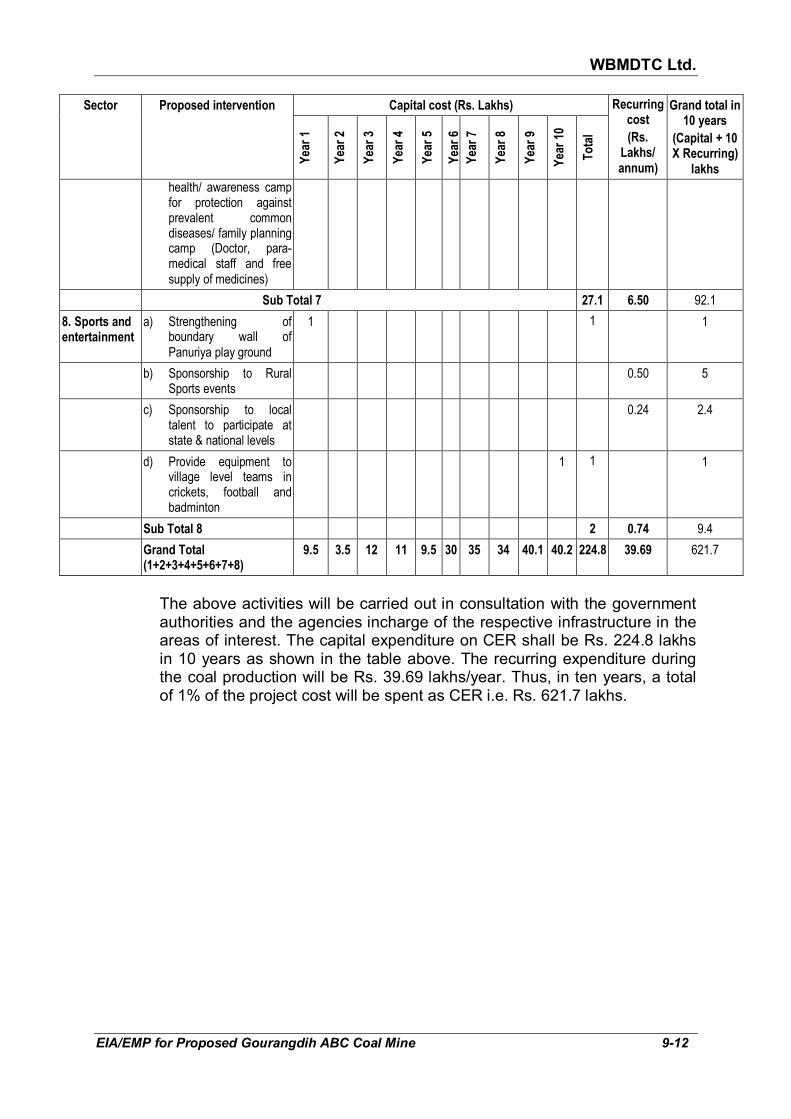
WBMDTC Ltd.
EIA/EMP for Proposed Gourangdih ABC Coal Mine 9-12
Sector Proposed intervention Capital cost (Rs. Lakhs) Recurring cost
(Rs. Lakhs/ annum)
Grand total in 10 years
(Capital + 10 X Recurring)
lakhs
Year 1
Year 2
Year 3
Year 4
Year 5
Year 6
Year 7
Year 8
Year 9
Year 10
Total
health/ awareness camp for protection against prevalent common diseases/ family planning camp (Doctor, para-medical staff and free supply of medicines)
Sub Total 7 27.1 6.50 92.1
8. Sports and entertainment
a) Strengthening of boundary wall of Panuriya play ground
1 1 1
b) Sponsorship to Rural Sports events
0.50 5
c) Sponsorship to local talent to participate at state & national levels
0.24 2.4
d) Provide equipment to village level teams in crickets, football and badminton
1 1 1
Sub Total 8 2 0.74 9.4
Grand Total (1+2+3+4+5+6+7+8)
9.5 3.5 12 11 9.5 30 35 34 40.1 40.2 224.8 39.69 621.7
The above activities will be carried out in consultation with the government authorities and the agencies incharge of the respective infrastructure in the areas of interest. The capital expenditure on CER shall be Rs. 224.8 lakhs in 10 years as shown in the table above. The recurring expenditure during the coal production will be Rs. 39.69 lakhs/year. Thus, in ten years, a total of 1% of the project cost will be spent as CER i.e. Rs. 621.7 lakhs.

WBMDTC Ltd.
EIA/EMP for Proposed Gourangdih ABC Coal Mine 10-1
CHAPTER 10
ENVIRONMENTAL COST BENEFIT ANALYSIS
The scope of the EIA/EMP has been prescribed through Terms of
Reference issued by Ministry of Environment, Forests and Climate Change vide Letter No. J-11015/80/2017-IA.II(M) dated 29th September, 2017. (Annexure I).
As per SO 1533 dated 14th September 2006, this chapter is to be prepared
if prescribed at scoping stage. The prescribed scope does not require environmental cost benefit analysis.
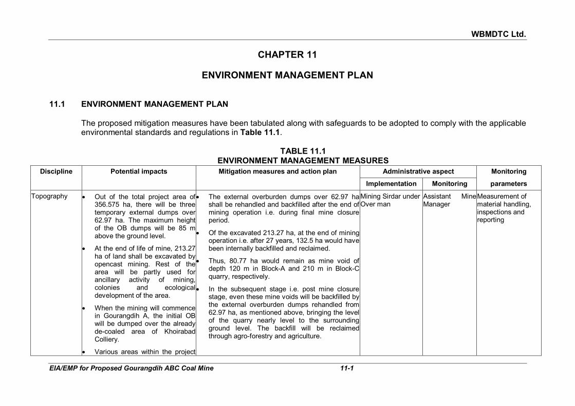
WBMDTC Ltd.
EIA/EMP for Proposed Gourangdih ABC Coal Mine 11-1
CHAPTER 11
ENVIRONMENT MANAGEMENT PLAN
11.1 ENVIRONMENT MANAGEMENT PLAN The proposed mitigation measures have been tabulated along with safeguards to be adopted to comply with the applicable
environmental standards and regulations in Table 11.1.
TABLE 11.1
ENVIRONMENT MANAGEMENT MEASURES
Discipline Potential impacts Mitigation measures and action plan Administrative aspect Monitoring
Implementation Monitoring parameters
Topography • Out of the total project area of 356.575 ha, there will be three temporary external dumps over 62.97 ha. The maximum height of the OB dumps will be 85 m above the ground level.
• At the end of life of mine, 213.27 ha of land shall be excavated by opencast mining. Rest of the area will be partly used for ancillary activity of mining, colonies and ecological development of the area.
• When the mining will commence in Gourangdih A, the initial OB will be dumped over the already de-coaled area of Khoirabad Colliery.
• Various areas within the project
• The external overburden dumps over 62.97 ha shall be rehandled and backfilled after the end of mining operation i.e. during final mine closure period.
• Of the excavated 213.27 ha, at the end of mining operation i.e. after 27 years, 132.5 ha would have been internally backfilled and reclaimed.
• Thus, 80.77 ha would remain as mine void of depth 120 m in Block-A and 210 m in Block-C quarry, respectively.
• In the subsequent stage i.e. post mine closure stage, even these mine voids will be backfilled by the external overburden dumps rehandled from 62.97 ha, as mentioned above, bringing the level of the quarry nearly level to the surrounding ground level. The backfill will be reclaimed through agro-forestry and agriculture.
Mining Sirdar under Over man
Assistant Mine Manager
Measurement of material handling, inspections and reporting

WBMDTC Ltd.
EIA/EMP for Proposed Gourangdih ABC Coal Mine 11-2
Discipline Potential impacts Mitigation measures and action plan Administrative aspect Monitoring
Implementation Monitoring parameters
will be disturbed for excavation (213.27 ha), external dump (62.97 ha), top soil dump (13.73 ha), infrastructure including colonies (27.23 ha) and roads (8 ha). Only 31.37 ha shall remain under plantation on green belt & undisturbed area.
• Drainage • A total of 1.73 km length of first order streams originating from project area will get affected due to excavation and external overburden dumps. Drains are 460 m near Bhatar Colony, 970 m near Shivdhaura and 300 m joining Noniya Jhore (near Quarry C).
• As these are origin points of first order streams, no nala diversions are envisaged.
• The mining activity will not affect the drainage system outside of the project area as the total activities will be done within the project area.
• Rainwater run off will be managed by construction of garland drains around the mine pit, along roads and OB dumps areas.
• The rainwater will be conveyed to the settling pond for settlement of suspended solids.
• Similarly, the rainwater falling directly into the mine pit will be collected in sumps to keep the working benches dry. Sump water will be pumped to the surface reservoir.
• Water collected in settling pond / surface reservoir will be reutilised and excess will be released into the nearby natural nala.
• Hence, there will not be any significant adverse impact on the drainage system due to pollutants from mine.
Junior Engineer Civil engineer Verification of construction of proposed structures, construction orders and completion reports
Air quality Fly rock and fugitive dust generation during drilling and blasting operation.
PM10, PM2.5, SO2, NO2 emission due to � Excavation � operation of excavators &
loaders,
• Use of dust suppressing systems such as fixed or mobile water spraying system at fugitive sources (working faces & loading point), haul roads, stock yards, dumps, coal stock yard and wherever required.
• Mobile sprinkling system on haul roads.
Blasting: Mining sirdar
Emmission Monitoring: Analyst from Envt. Dept
Plantation: Gardner
Safety Officer and OIC-Environment
Air quality parameters monitoring by self or by third party
Verification of cover of trucks, dust suppression

WBMDTC Ltd.
EIA/EMP for Proposed Gourangdih ABC Coal Mine 11-3
Discipline Potential impacts Mitigation measures and action plan Administrative aspect Monitoring
Implementation Monitoring parameters
� Loading of dumpers (fugitive dust)
� Movement of dumpers on haul roads (dust & gases)
� Dumping (dust) � Operation of other fossil fuel
based equipment/ machinery � Fugitive dust � Coal Handling plant
• Automatic fixed sprinklers (Whirling) along main haulage road
• Transport vehicles will be maintained periodically as per the manufacturers’ norms and maintained spill proof. They will be covered during transportation of mineral. No overloading shall be permitted. All heavy and light vehicles shall be well maintained and will have their “Pollution Under Control” (PUC) certificates.
• Tree plantation will be carried out along the mine periphery (7.5 m), in safety zone between Panuriya & Gourangdih villages habitation and quarry area (45 m), along the sides of haul roads (outside quarry area or working dumps) and other vacant area
• Provision of reclamation of dump and later backfill with plantation, agroforestry and agriculture
• CHP will be housed in a closed structure and have air pollution control equipment
measures & plantation
Water quality Suspended solids due to
• soil in run-off during heavy precipitation
• Wash offs from dumps
• Pumping of mine water
• Soil erosion from mine and roads
• Oil spillage at the pit head and at the facilities viz. workshop,
• Mine water will be collected in the central sump, pumped from sump to surface reservoir. Run-off around reclamation area and external dump will be led to settling pond and will be utilized for mine activities, plantation, etc. after settlement of suspended solids. Excess water will be discharged to the natural water course.
• For the workshop, oil water separator shall be provided. The oil is skimmed off and sold to authorised recycling vendors and the bottom sediment disposed in impervious pit. The water
,Workshop manager, Junior engineer from civil and STP operator
Assistant Mine Manager
Verification of settling tanks, OWS, etc. Monitoring of water quality prior to discharge

WBMDTC Ltd.
EIA/EMP for Proposed Gourangdih ABC Coal Mine 11-4
Discipline Potential impacts Mitigation measures and action plan Administrative aspect Monitoring
Implementation Monitoring parameters
resulting in oil and grease contamination of surface water if appropriate control measures are not adopted.
will be reused in vehicle washing.
• Sewage generated within the mining lease will be treated in septic tank & soak pit systems.
• The sewage from the colony will be treated in STP. The sludge from STP shall be composted and used as manure for plantation and green belt.
Water table • Intersection of ground water table due to OC workings.
• Mine seepage water to be pumped out to keep working area dry & workable.
• Decline of water table in radius of influence.
• Mine seepage water will be collected at the mine sump, from sump to surface reservoir and after settling of suspended solid, the pumped out water will be utilized for industrial and domestic purposes to the extent possible excess water will be discharge in nearby natural drainage.
• Supply of potable water in affected areas within radius of influence.
• Rain water harvesting structures shall be there for ground water recharge.
Assistant Mine Manager
Mine Manager Piezometer monitoring station, pumping records, monitoring of water quality parameters
Land • The total project area is 356.57 ha. Out of this, 213.27 ha land i.e. 59.1% will be disturbed by excavation till the end of life of mine.
• However, concurrent backfilling will be done from 5th year onwards of mining operation. Till the 27th year, 132.5 ha out of total excavated area 213.27 ha i.e 62.12% land will backfilled by internal dumps.
• The disturbed area within project during the tenure of mining with
• An important aspect of the mitigating the impact on agricultural land is to attempt to save the fertile top soil. For that purpose, the mine plan has provisioned for 3.19 Mcum of top soil to be removed during the life of the mine and to be stacked separately in soft OB i.e. top soil dump. This top soil will be simultaneously reutilized in plantation of green belt along periphery and in safety zone
• Once the simultaneous backfilling of mine void commences from 5
th year, the reclamation process
over the backfilled area will also commence. Reclamation of external OB dumps as well as topo soil dump will also eventually take place.
Sirdar, Over man and junior engineers
Assistant Mine Manager
Volume of material handled, survey for area measurements, plantation inventory.

WBMDTC Ltd.
EIA/EMP for Proposed Gourangdih ABC Coal Mine 11-5
Discipline Potential impacts Mitigation measures and action plan Administrative aspect Monitoring
Implementation Monitoring parameters
comprise excavated land, external dumps, void area, area occupied by infrastructure including roads, CHP, offices, colony, etc.
• 48.43 ha of agricultural land in the project area will be changed due to opencast working.
• The pre-mining land records of project area also show 109.459 ha forest land (protected & jungle) which are going to get disturbed due to mining activities.
• At the mine closure stage, the excavated area of both the quarry will be fully reclaimed by backfilling and rehandling of external dumps. After mine closure, the total reclaimed area will be 304.2 ha.
• The reclaimed area will be 238.4 ha under agro-forestry, 0.19 ha under plantation and 65.61 ha under agriculture.
• At the end of life of the mine the total afforested area will be 304.2 ha comprising 62.97 ha external OB dump, 13.73 top soil dump, 213.27 ha excavation, 4 ha roads and 10.23 ha built up area.
• After closure of mine, 48.43 ha of affected agricultural land (of pre-mining stage) will be compensated by 65.61 ha. Thus, after 27 year, the overall agriculture area will increase.
• Even though 109.459 ha forest will get disturbed, after closure of mine and carrying out reclamation, 238.4 ha of land is proposed under agro-forestry. Although the nature of the forest will change from the current natural forest to one which has more economical value as it will be planted with the intent to harvest forest-produce. Therefore, the intent of the company is to replace the 109.459 ha with 238.4 ha of forests after closure of mine.
Solid Waste • Pollution of air due to handling of OB and rejects,
• Pollution of ground water due to suspended solids in runoff
• Pollution due to improper disposal of wastes
TOP soil Management
• The total topsoil generated will be 3.19 Mcum during the life of the mine which will temporary stored at designated place to maintain its fertility and later it will be reused in reclamation process.
• Garland drains followed by settling tank will be provided around the top soil dump to arrest any soil from the dump from being carried away by the rain water.
• Overman
• STP Operator
• Assistant mines manager
• Civil engineer
• Log of solid waste handling and disposal
• OB and TS handling records
• Log books of OWS
• Surprise checks

WBMDTC Ltd.
EIA/EMP for Proposed Gourangdih ABC Coal Mine 11-6
Discipline Potential impacts Mitigation measures and action plan Administrative aspect Monitoring
Implementation Monitoring parameters
• The top soil dump will be stabilised on non working faces through plantation or geo-textiles to minimise gully formation
Hard OB management
• The overburden is proposed to be dumped both externally and internally for concurrent backfilling.
� Initially upto 4th year the OB generated will be dumped at external OB dump fully over an area of 71.50 ha. Thereafter i. e. from the 5th year itself, OB generated will be dumped both externally as well as internally for backfilling.
� At the end of mining operation after 27 years of project life, the total volume of internal dump will be 129.18 Mcum over an area of 132.50 Ha (Hard OB and soft OB, both).
� At the end of mining operation the height of external dumps and internal dumps would be about 85 and 60 m above adjacent ground level.
� However, at the mine closure stage, the dump will be regraded so as to make the top of the dumps nearly level with adjacent ground topography. The areas of both the quarries will be fully reclaimed.
� While the external dumps exist, the following mitigation measures will be required to minimise erosion :
� Retaining walls (with gabion, concrete or local stone) will be provided, wherever required, to support the benches or any loose material and also to arrest sliding of loose debris.
� Garland drains along the retaining walls or along bench contours leading to settling
• Verification by observation

WBMDTC Ltd.
EIA/EMP for Proposed Gourangdih ABC Coal Mine 11-7
Discipline Potential impacts Mitigation measures and action plan Administrative aspect Monitoring
Implementation Monitoring parameters
tank will be provided around the OB dump to arrest any particles from the dump area from being carried away by the rain water.
� The bench levels will be provided with water gradient against the general pit slope to decrease the speed of storm water and prevent its uncontrolled descent.
� Special local stone paved chutes and channels will be provided wherever required, to allow controlled descent of water
� Gullies formed, if any, on side of the benches shall be provided with check dams of local stone or sand filled bags.
� The inactive dump slopes will be planted with bushes, grass, shrubs and trees to prevent soil erosion after applying topsoil.
• The sludge removed periodically from the septic tanks in the mining area would be organic in nature.
• The STP sludge from colony would also be organic in nature. The organic matter will be composted to be used as manure in afforestation/ greenbelt/ agroforestry/ agriculture.
• The silt and soil sludge in settling ponds will be periodically removed and disposed in the OB dump area.
• The municipal solid waste shall be segregated at source and the organic component shall be composted at the designated site within the project area. The composted matter will be used as manure in plantation.
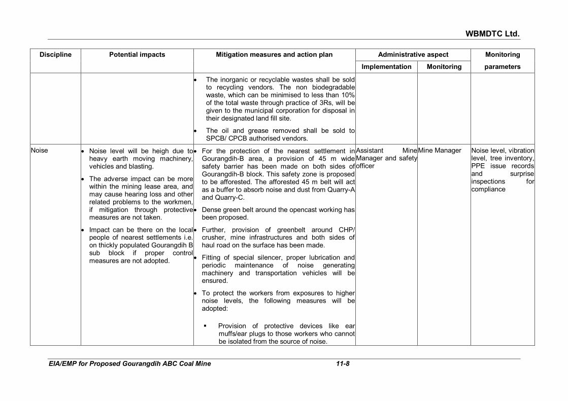
WBMDTC Ltd.
EIA/EMP for Proposed Gourangdih ABC Coal Mine 11-8
Discipline Potential impacts Mitigation measures and action plan Administrative aspect Monitoring
Implementation Monitoring parameters
• The inorganic or recyclable wastes shall be sold to recycling vendors. The non biodegradable waste, which can be minimised to less than 10% of the total waste through practice of 3Rs, will be given to the municipal corporation for disposal in their designated land fill site.
• The oil and grease removed shall be sold to SPCB/ CPCB authorised vendors.
Noise • Noise level will be heigh due to heavy earth moving machinery, vehicles and blasting.
• The adverse impact can be more within the mining lease area, and may cause hearing loss and other related problems to the workmen, if mitigation through protective measures are not taken.
• Impact can be there on the local people of nearest settlements i.e. on thickly populated Gourangdih B sub block if proper control measures are not adopted.
• For the protection of the nearest settlement in Gourangdih-B area, a provision of 45 m wide safety barrier has been made on both sides of Gourangdih-B block. This safety zone is proposed to be afforested. The afforested 45 m belt will act as a buffer to absorb noise and dust from Quarry-A and Quarry-C.
• Dense green belt around the opencast working has been proposed.
• Further, provision of greenbelt around CHP/ crusher, mine infrastructures and both sides of haul road on the surface has been made.
• Fitting of special silencer, proper lubrication and periodic maintenance of noise generating machinery and transportation vehicles will be ensured.
• To protect the workers from exposures to higher noise levels, the following measures will be adopted:
� Provision of protective devices like ear
muffs/ear plugs to those workers who cannot be isolated from the source of noise.
Assistant Mine Manager and safety officer
Mine Manager Noise level, vibration level, tree inventory, PPE issue records and surprise inspections for compliance

WBMDTC Ltd.
EIA/EMP for Proposed Gourangdih ABC Coal Mine 11-9
Discipline Potential impacts Mitigation measures and action plan Administrative aspect Monitoring
Implementation Monitoring parameters
� Confining the noise by isolating the source of noise.
� Reducing the exposure time of workers to the higher noise levels.
� The operators of stripping and coal winning equipment will be accommodated in cabins which are acoustically designed and air conditioned.
• For CHP/ Crusher, where the crushing and other vibrating equipment will generate noise level of around 85-90 dB (A), the following measures will be taken:
� The crushing and vibrating equipment will be
in a covered building, thus, reducing noise propagation to the surrounding area.
� Noise absorbent and anti vibration paddings have been proposed between foundation and base plate of the machinery.
� Chutes at transfer points in coal handling plant shall be lined properly for noise absorption.
� Regular maintenance and prompt replacement of worn out parts shall be ensured.
� The workers exposed to high noise levels will be provided with earplugs / ear muffs.
� Plantation will be done in and around the CHP/ crusher premises to attenuate any residual noise.
Ground vibration & Blasting
• Ground vibrations on roads due to the movement of HEMM.
• Drilling and blasting of exposed
• Vibration due to traffic can be reduced by constructing and maintaining the roads in good quality
Mining Sirdar and Overman
Assistant Mine Manager
Ground vibration study

WBMDTC Ltd.
EIA/EMP for Proposed Gourangdih ABC Coal Mine 11-10
Discipline Potential impacts Mitigation measures and action plan Administrative aspect Monitoring
Implementation Monitoring parameters
hard strata may result in minor cracks on surface if controlled blasting techniques are not adopted.
• In view of the location of the project to close proximity to thickely populated village i.e Gourangdih and Panuriya, Controlled blasting techniques including muffled blasting will have to be adopted during blasting within 300 m zone but beyond 100 m from the village, dwellings, surface structures, road etc.
• Drilling and charging pattern will be modified, if required, based on any vibration study to be carried out in future.
• Each blast will be carefully planned, checked, executed and observed. During blasting, a responsible officer will be supervising the whole operation.
• Blasting will be carried out during day time only. Blasting will not be carried out when strong winds are blowing towards the inhabited areas.
Traffic impacts Impact on air quality and noise due to vehicular movement resulting into impacts on habitation including flora and fauna falling along the coal transportation route.
• Improvement of internal roads and road outside the ML which will be used for transportation coal to the railway siding by strengthening and its maintenance,
• Optimum weight to be carried by the truck and over loading prohibited
• The transportation vehicles will under go for “Pollution Under Control (PUC)” checkups on every six months to obtain PUC certificate and Periodic maintenance of the truck as per manufacturers specifications for best fuel efficiency shall be ensured.
• Water sprinkling at load points as well as on road and covering of trucks with tarpaulin will be
A separate supervisor for traffic management under Foreman
Asistant Mine Manager
Observation of condition of roads, Verification by observation and surprise checks

WBMDTC Ltd.
EIA/EMP for Proposed Gourangdih ABC Coal Mine 11-11
Discipline Potential impacts Mitigation measures and action plan Administrative aspect Monitoring
Implementation Monitoring parameters
ensured.
Facilities for the trucks and truck drivers:
(i) Designated parking area prior to loading and also after loading
(ii) Designated space for loading
(iii) Weigh bridges
(iv) Rest rooms for drivers
(v) Canteen for all employees, which can also be availed by drivers
(vi) Truck cleaning zone
Terrestrial ecology & greenbelt
• Impact on species of flora and fauna in the form of relocation for their survival, due to diversion of proposed 109.459 ha forest land (Protected and Jungle).
• Dust emission from mine due to excavation and transportation, affects the effective photosynthesis by covering the plant/ tree leaves by thin dust layer during dry months which however will be washed away in rainy months.
• Disturbance to birds and animals due to bright light and unusual noise during operation activity.
• Compensatory plantation shall be done on encumbrance free 111.32 ha of government land provided by the Additional District Magistrate & District Land & Land Reform Officer, Purb Bardhman..
• Establishment of greenbelt having width 7.5 m and plantation along various facilities and periphery.
• Plantation on 45 m wide safety zone between Quarry A and settlements of Panuriya and Gourandih as well as between Quarry C and these settlements shall be carried out.
• The plantation program in the project area will be implemented in a phased manner throughout life of mine in peripheral greenbelt (7.52 ha), 132.5 ha over backfilled area, 62.97 ha over external dumps and 23.85 ha over undisturbed area.
• For safeguarding fauna
• The greenbelt around facilities, periphery and along roads will result in small sized fauna such as squirrels, hare, etc., reptiles and birds in finding a
Gardner OIC environment Tree inventory, tree cutting permission, if required; boundary inspection, new plantation inventory and inspection, waste water reuse log book

WBMDTC Ltd.
EIA/EMP for Proposed Gourangdih ABC Coal Mine 11-12
Discipline Potential impacts Mitigation measures and action plan Administrative aspect Monitoring
Implementation Monitoring parameters
favorable habitat.
• The roads leading to and from the mine shall have caution boards warning drivers to slow down for animal crossings, if any develop in the future.
• The drivers shall be sensitized not to hit stray animals on the road.
• The emissions from the mines shall always be kept within the norms so that surrounding environment will always be clean and comfortable for humans, wildlife and vegetation.
• The company shall interact with the Divisional Forest Officer and find out whether any schemes are ongoing for the protection of the wildlife. If such schemes are ongoing, then monetary or logistic support shall be extended by the company. For example, the company can supply water to watering holes in the forests in study area during dry season
• While carrying out social welfare activities, awareness about the variety of faunal species, their status of endangerment and behavior will be spread through posters/ seminars/workshops or discussions to sensitize the villagers.
Demography and socio-economics
• The project falls under seven villages which are Shibdhara, Bandhaura, Lalbandh in Block-A and part of Panuriya, Kantapahari, Gourangdih & Bhuiapara in Block-C.
• Total 629 houses and various other PAFs under different
• The financial implications of the R&R package is expected to be in the range of INR 91.81 Crores (PAF Opt for employment) to 105.95 Crores (In case PAF not opt for employment).
• It may be noted that the above financial costs are tentative in nature and subject to change based on actual R&R activities undertaken at the time of rehabilitation and resettlement of the PAFs.
• Rehabilitation and Resettlement Committee under the chairmanship of the District Magistrate
• Mine Agent Survey and to identify structures, action taken for evacuation, to ensure proper implementation of R&R Plan.

WBMDTC Ltd.
EIA/EMP for Proposed Gourangdih ABC Coal Mine 11-13
Discipline Potential impacts Mitigation measures and action plan Administrative aspect Monitoring
Implementation Monitoring parameters
categories have been identified in total project area which will be rehabilitated and resettled.
• Resettlement Colony - The land for Resettlement Colony (RC) will be made available by the project proponent free of any encumbrances, preferably at one place, at the time of inception of the project) and Provision of basic infrastructure (basic infrastructure facilities for community development works depending upon the need and requirement, to be determined and consultation with the stakeholders.
• Besides above, following additional benefits will be taken
• Additional benefit to forest dwellers under the Scheduled Tribes and other Traditional Forest Dwellers (Recognition of Forest Rights) Act, 2006 shall be made for forest dwellers.
• Additional Efforts for Community development (CD): Provision of various facilities and amenities such as roads, schools, health care unit, tree plantation, community hall, electric power connection, children’s playground, safe drinking water outlets, drainage & sanitation, etc. at the resettlement site for socio-economic development of the project affected area.
Fire and safety Accidents/disasters related to fire and safety
• Sufficient fire extinguishers and sufficient number of water hydrants with sufficient hose will be installed during operation at selected locations on surface like Electrical Sub-stations, workshop, Garage, Diesel Depot, Stores etc. for fire protection
• Well trained professional groups will be there to control the emergency situations. The group will comprise three teams, namely, Control team,
Mine Safety Officer and OIC-Envt.
Mine Manager Verification of approvals from safety inspector, training, verification of fire fighting equipment
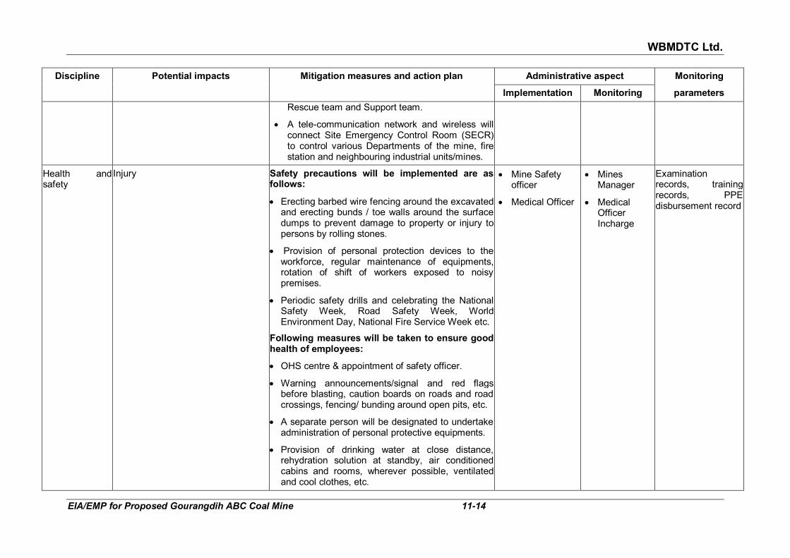
WBMDTC Ltd.
EIA/EMP for Proposed Gourangdih ABC Coal Mine 11-14
Discipline Potential impacts Mitigation measures and action plan Administrative aspect Monitoring
Implementation Monitoring parameters
Rescue team and Support team.
• A tele-communication network and wireless will connect Site Emergency Control Room (SECR) to control various Departments of the mine, fire station and neighbouring industrial units/mines.
Health and safety
Injury Safety precautions will be implemented are as follows:
• Erecting barbed wire fencing around the excavated and erecting bunds / toe walls around the surface dumps to prevent damage to property or injury to persons by rolling stones.
• Provision of personal protection devices to the workforce, regular maintenance of equipments, rotation of shift of workers exposed to noisy premises.
• Periodic safety drills and celebrating the National Safety Week, Road Safety Week, World Environment Day, National Fire Service Week etc.
Following measures will be taken to ensure good health of employees:
• OHS centre & appointment of safety officer.
• Warning announcements/signal and red flags before blasting, caution boards on roads and road crossings, fencing/ bunding around open pits, etc.
• A separate person will be designated to undertake administration of personal protective equipments.
• Provision of drinking water at close distance, rehydration solution at standby, air conditioned cabins and rooms, wherever possible, ventilated and cool clothes, etc.
• Mine Safety officer
• Medical Officer
• Mines Manager
• Medical Officer Incharge
Examination records, training records, PPE disbursement record
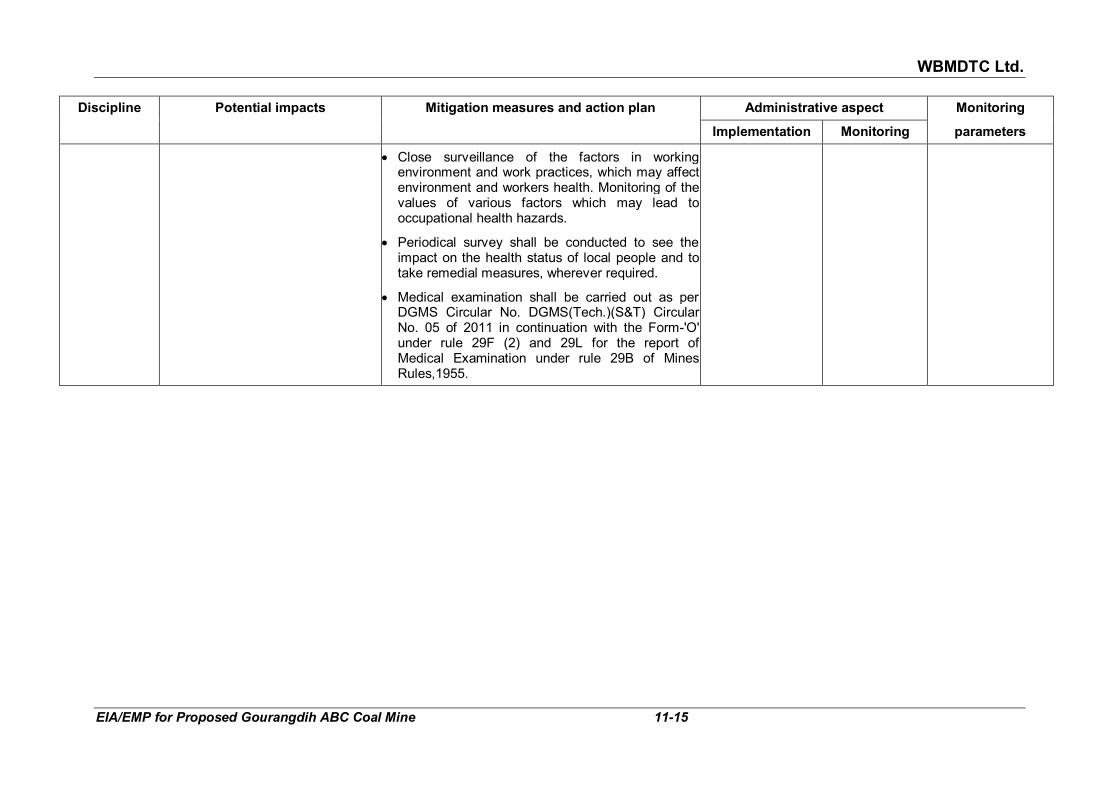
WBMDTC Ltd.
EIA/EMP for Proposed Gourangdih ABC Coal Mine 11-15
Discipline Potential impacts Mitigation measures and action plan Administrative aspect Monitoring
Implementation Monitoring parameters
• Close surveillance of the factors in working environment and work practices, which may affect environment and workers health. Monitoring of the values of various factors which may lead to occupational health hazards.
• Periodical survey shall be conducted to see the impact on the health status of local people and to take remedial measures, wherever required.
• Medical examination shall be carried out as per DGMS Circular No. DGMS(Tech.)(S&T) Circular No. 05 of 2011 in continuation with the Form-'O' under rule 29F (2) and 29L for the report of Medical Examination under rule 29B of Mines Rules,1955.

Damodar Valley Corporation (DVC)
EIA/EMP for Proposed Gourangdih ABC Coal Mine 11-16
11.2 CORPORATE ENVIRONMENT POLICY WBMDTC has a well laid down Environmental Policy which was approved
in it’s 204th Meeting of Board of Directors dated 28th September, 2012 (refer Annexure XXVI), which is presented below:
Corporate Environmental Policy
Policy Statement:
“West Bengal Mineral Development and Trading Corporation Limited
affirms its commitment for environment friendly mining with right mitigation of pollution, reclamation of the degraded land, preservation of biodiversity and proper disposal of waste following the best environmental practices including judicious use of the non-renewable energy on the path of continual improvement.”
Objectives:
West Bengal Mineral Development & Trading Corporation Limited shall
endeavour to:
1. Conduct mining and associated operation in an environmentally responsible manner to comply with applicable laws and other requirements related to environmental aspects. Design projects with due consideration of sustainable Development.
2. Prevent pollution of surrounding habitation by continuous monitoring and adopting suitable measures for environment protection.
3. Ensure compliance of all applicable EC conditions, FC conditions and other statutory conditions issued by regulatory agencies.
4. Implement EMPs in all the projects effectively to mitigate pollution on air, water and noise, reclamation of degraded land and proper disposal of wastes.
5. Strive to conserve Bio-Diversity.
6. Conserve natural resources through recycling of wastes on the principle of REDUCE, RECYCLE and REUSE. Put special thrusts on efficient energy utilization as a measure to reduce carbon foot-print.
7. Strive for continual improvement in our environmental performances by setting targets, measuring progress and taking corrective action.
8. Create environmental awareness among the employees and the local communities through pro-active communication and training.
9. Enhance environmental awareness amongst employees working for and on behalf of the corporation and the general populace around the projects.
10. Encourage its business associates to adopt similar approach for environmental protection.

Damodar Valley Corporation (DVC)
EIA/EMP for Proposed Gourangdih ABC Coal Mine 11-17
11.3 STANDARD OPERATING PROCESS / PROCEDURES TO ADDRESS DEVIATION/ VIOLATION
An Environmental Manual will be prepared, as part of the Environmental Management. The Manual shall be prepared to comply to the Corporate Environmental Policy covering the following aspects:
� Environment clearance conditions/ stipulations/ norms
� Consent to operate conditions / stipulations / norms
� Monitoring mechanism for compliance through periodic audits
� Reporting of the audit results
� Corrective and Preventive Actions to be taken
� Self improvement measures 11.3.1 Hierarchical systems to deal with the environmental issues and for
ensuring compliance WBMDTCL will handle environmental issues of Gourangdih ABC Mine
headed by the General Manager (Projects) posted at HO, Kolkata. At the project level, Mine Agent of Gourangdih ABC mine will have the responsibility for the compliance within the lease area. He will be assisted by the Mine Safety Officer & OIC-Env who will in turn take action down the line through various subordinates to implement various environmental conditions.
11.3.2 Systems of reporting of non compliances/violations Half yearly Progress Report to the conditions imposed by MOEF&CC in
respect of Environmental Clearance of mines shall be uploaded at Company’s website regularly. Deviations from the policy and cases of violation of Environmental Clearance conditions as found by MoEF&CC and WBPCB or other public authority will be reported to Board of Directors and corrective as well as preventive action will be taken. The system will function as follows:
Inputs � Periodic Manual monitoring data
� Perusal of data from manual or online AAQ monitoring systems
� NOC/ EC conditions compliance status
� Inspection report of MOEF
� Inspection report of SPCB
� Complaints from local people, NGO or any other
� Environmental statement (Form V)
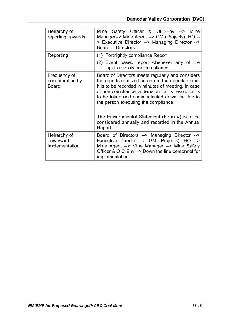
Damodar Valley Corporation (DVC)
EIA/EMP for Proposed Gourangdih ABC Coal Mine 11-18
Heirarchy of reporting upwards
Mine Safety Officer & OIC-Env --> Mine Manager--> Mine Agent --> GM (Projects), HO --> Executive Director --> Managing Director --> Board of Directors
Reporting (1) Fortnightly compliance Report
(2) Event based report whenever any of the inputs reveals non compliance
Frequency of consideration by Board
Board of Directors meets regularly and considers the reports received as one of the agenda items. It is to be recorded in minutes of meeting. In case of non compliance, a decision for its resolution is to be taken and communicated down the line to the person executing the compliance.
The Environmental Statement (Form V) is to be considered annually and recorded in the Annual Report.
Heirarchy of downward implementation
Board of Directors --> Managing Director --> Executive Director --> GM (Projects), HO --> Mine Agent --> Mine Manager --> Mine Safety Officer & OIC-Env --> Down the line personnel for implementation.

WBMDTC Ltd.
EIA/EMP for Proposed Gourangdih ABC Coal Mine 12-1
CHAPTER 12
EXECUTIVE SUMMARY OF EIA/EMP 12.1 INTRODUCTION 12.1.1 General background M/s West Bengal Mineral Development and Trading Corporation Limited
(WBMDTCL) has been allotted Gourangdih ABC Coal Mine by Ministry of Coal in September 2016.
The total block area is 370 hectare and the project area is 356.575 hectare.
Gourangdih ABC block has been considered in 3 sub blocks namely, Gourangdih Block-A, Gourangdih Block-B and Gourangdih Block-C (Refer Fig 12.1). In view of surface constraints, Block-B is not planned to be
mines. Annual production target is 2.5 million tonnes per annum at an overall stripping ratio of 2.91 cum/tonne. The total life of mine worked out is 27 years.
12.1.2 Location and communication
The mine is located in villages Panuria (or Panuriya), Kantapahari, Jamgram, Shibdhawra (or Shibdhara), Banddhawra, Lalbandh, Gourangdih and Bhuiapara in Barabani CD Block of District Paschim Bardhaman, West Bengal. The mine lies in the Survey of India, Open Series Map no. F45C13 and F45D1. The area is bound by Latitude 23°48'30" to 23°49'45" N and Longitude 86°57'45" to 87°00'15" E. The location map is given in Fig 1.1 of
Chapter 1.
The area is well connected by metalled roads via Asansol to NH-2 (from Kulti to Durgapur) located 13.4 km in south south west. Two roads pass through the project area. One is Asansol-Gourangdih road connecting Runakuraghat via Jamgram, which passes over the eastern flank of Block-C quarry. Second is Rupnarayanpur-Gourangdih road, which passes through Block-A in western portion. At a later stage, these roads are proposed to be diverted as they will pass through quarry area. The nearest railways station is Rupnarayanpur at a distance of 7.8 km, in south. Kolkata airport is situated at a distance of about 195 km south east and Andal airport is at a distance of 40 km south east.
12.2 PROJECT DESCRIPTION 12.2.1 Geology and reserves
The project lies in Raniganj Coalfield. Barakars of Gondwana formation is exposed in Gourangdih ABC Coal Block. Talchirs and Post Gondwana

WBMDTC Ltd.
EIA/EMP for Proposed Gourangdih ABC Coal Mine 12-2
intrusives were intersected in few boreholes during exploration. On the basis of drilling, eight distinctly correlated and persistent coal horizons have been identified in the Barakars. They are called B-I, B-II, B-III (Top), B-III (Bottom), B-IV, B-V, B-VI and B-VII. Exposure of coal is rare and mainly confined to the quarries. The thickness of seams to be worked on varies from 1 m to 25.07 m. Grade of coal varies from C to G and is non-coking coal. Stripping ratio is 2.91 Cum/t. Average Gradient of seam is 8 to 13 degrees.
Net geological reserves in the block was 129.15 million tonnes. Reserves
are locked up below densely populated and heavily built up areas of Gaurangdih, Panuriya and Kantapahari villages. Reserves are also blocked in batters of Quarry A & Quarry C and some reserves had already been extracted in the past. Thus, reserves sterilized or not available are 60.78 million tonnes and net available geological reserves are 68.37 million tonnes. After subtracting mining loss of 10%, net mineable reserves are 61.54 million tonnes.
12.2.2 Mining Opencast mining method has been selected for the proposed mine.
Capacity of the mine will be 2.5 million tonnes per annum. Shovel and dumper combination has been considered as the most suitable technology under prevailing geo-mining conditions. These conditions are limited strike length and presence of a number of faults (17 faults). A combination of horizontal and inclined stripping has been proposed. This has been proposed in view of steep deposit and to minimize the dilution during mining.
For open cast operation the top soil will have to be removed first with
backhoes and rear dumpers. The overburden benches will be worked with hydraulic shovels and dumpers. 160 mm dia RBH drills will be used for drilling. Blasting will be by SMS explosives. All the partings less than or equal to 12 m will also be drilled by same drills. Coal from the opencast faces will be loaded by diesel hydraulic shovels and backhoes onto 60 T coal body rear dumpers for hauling it to quarry surface.
Mining operation shall be started first in Block-A quarry from the north west.
The mining operation will start from the existing Khoirabad face. Block-C quarry will start operation from the 2nd year of mining activity from north west side of the quarry. Block-C will yield more coal than Block-A due to its having more reserves.
Coal beneficiation is not planned at the project site since all the seams are
generally free from any dirt band. Only a Coal Handling Plant (CHP) of 2.5 MTPA capacity is proposed. Thereafter dispatching of crushed coal to various consumers will be done.
The Sequence of Mining have been shown through a line diagram below:

WBMDTC Ltd.
EIA/EMP for Proposed Gourangdih ABC Coal Mine 12-3
FIG 12.1: MAP SHOWING SUB-BLOCKS AND SEQUENCE OF MINING
12.2.3 Site services Core infrastructure like mine office & common facilities, residential buildings,
power distribution system, Excavation workshop, E&M Workshop cum Project Store, Magazine, road, telecommunication, First Aid centre, canteen etc. shall be established at the mine site.
Total requirement of water is estimated as 530 KLD for potable and 454
KLD for industrial purpose. Source of raw water required for the project and residential colony shall be Ajay River till the mine seepage water becomes available in sufficient quantity for use.
The total power requirement for the proposed mine will be about 5275 KW.
It will be supplied by West Bengal State Electricity Board (WBSEB). For power backup, 5790 KVA diesel generator are proposed.
12.2.4 Manpower Total manpower required will be 762 of which 494 will be for mining and 268
will be for ancillary jobs. 12.3 PRESENT ENVIRONMENTAL SCENARIO
The lease area is referred to as “core zone”. Area falling within 10 km from
boundary of core zone is referred to as “buffer zone”. Together, both of them form the “study area”. The map showing the study area is given in Fig 3.1 of Chapter 3.
12.3.1 Topography and drainage Core zone: Topography has gentle undulations. Slope of southern part is
towards south and of northern part is towards north. The elevation varies between 135 to 174 m amsl. Old quarries are present in western portion (Khoirabad quarry) and eastern portion (Debu quarry) of the project. The

WBMDTC Ltd.
EIA/EMP for Proposed Gourangdih ABC Coal Mine 12-4
quarries had been worked in the past by other companies and were abandoned. Three first order seasonal drains from northern portion of project area ultimately joining Ajay river. One first order stream from southern portion of the project flows into Noniya Jhor nala. Village ponds as well as old abandoned open cast quarries filled with water are present in the core zone.
Buffer zone: Area north of the project slopes towards Ajay river. The area
south of the project is sloping towards Noniya Jhor Nala. Ajoy River and Noniya jhor control the drainage in the study area. The drainage pattern of the study area is dendritic in nature. The surface elevation varies from 93 to 180 m amsl. The area is rich in coal reserves, therefore, several coal blocks are present in the study area. These have disturbed the topography by formation of pits and dumps.
12.3.2 Climate and micro-meteorology
The district experiences warm temperate rainy climate with mild winter. The
cold season starts from middle of November and continues till the end of February. March to May is dry summer intervened by tropical cyclones and storms. June to September is wet season while October and November is autumn. Long term data is available from IMD station - Bankura (MO), located at a distance of 62 km from the project. Monthly mean of temperatures range from 11.4°C to 37.4°C. The annual average rainfall is 1564 mm.
Micro-meteorological data was recorded at site for 3 months from
01.12.2017 to 28.02.2018. The temperature recorded varied from 10.12 to 30.34°C with an average of 22.45°C. Relative humidity varied from 33.70 to 89.90% with an average of 65.10%. The predominant wind direction was observed from north with 35.17% of occurrences including calm.
12.3.3 Ambient air quality Ambient air quality was studied at eight locations from December 2017 to
February 2018. Two stations were established in project area and six stations in the buffer zone. Ambient air quality stations were established at Block A, Block C, Gourangdih (0.35 km between blocks A &C), Kantapahari (0.3 km, SE), Kashidanga (1.5 km, E), Kashidangal (0.2 km, N), Baradang (0.9 km, S) and Aliganja (1.2 km, N). The PM10 concentration of the study area ranged from 45.0 µg/m3 to 78.0 µg/m3, PM2.5 from 24.6 µg/m3 to 45.3 µg/m3, SO2 from 6.3 to 12.1 µg/m3 and NO2 from 8.3 µg/m3 to 16.7 µg/m3. All values of PM10, PM2.5, SO2 and NO2 are within the permissible limits of National Ambient Air Quality standard i.e. NAAQS 2009.
12.3.4 Water environment and quality
Surface water has been discussed in section 12.3.1 earlier. Ground water
occurs in Archaean metamorphics. In Salanpur block, it is at about 82 m bgl under confined and at 150 m bgl in unconfined condition. The dynamic

WBMDTC Ltd.
EIA/EMP for Proposed Gourangdih ABC Coal Mine 12-5
ground water resources of Bardhman district has been estimated jointly by CGWB and SWID, Government of West Bengal. Stage of Ground Water Development has been identified as 43.49%. Gourangdih ABC coal block comes under Barabani Block which is in safe category as per estimation. Water level have been measured in 48 open wells in study area in January 2018. The depth to water table varied from 0.61 m bgl to 9.14 m bgl with an average of 4 m bgl.
Eight ground water samples were collected from Core Zone (Block A), Core
Zone (Block C), Gourangdih, Kantapahari, Kashidangal, Daskiari, Mirzapur and Alipur Village. Eight surface water samples were collected from Core Zone (Block C), Gourangdih, Kashidangal, Baradang, Near Jitpur, Near Shyamapur, Jamgram and Panuriya village. One supply water sample from Panuriya village was collected. In surface water, all parameters were found to be within the desirable limits as per IS: 10500:2012 except turbidity in six samples, which exceeded the permissible limits. This makes surface water suitable for drinking after treatment for turbidity. In ground water, all parameters were found to be within the desirable limits except total hardness, alkalinity and TDS, which were within permissible limits as per IS: 10500:2012. This makes it suitable for drinking in absence of any alternative source. In supply water all parameters were found to be within the desirable limits and is potable.
12.3.5 Land use pattern and soil quality
Land use: Total project area is 356.575 hectare. This includes applied ML
area of 213.27 hectare and 143.305 ha outside of the ML. Presently, the land use of core zone comprises of Agricultural Land (48.43 hectare), Fallow land (Danga) (44.07 hectare), Degraded land (Old quarry area) (61.316 hectare), Built up area (60.86 hectare), Water body (15.44 hectare), Forest land (protected & jungle) (109.459 hectare), Non agricultural land for colony (outside core area) (5.00 hectare) and Non agricultural land for Rehabilitation (outside core area) (17.0 hectare). The mine had been operated by other companies in the past. As per Census data 2011, within study area, the net shown area accounts for a major portion (58.09%) followed by area under non-agricultural use (30.71%), culturable waste land (8.36%) and forest land (only 1.76%).
Soil Quality: The soil samples were collected from four locations namely,
Core Zone (Block A), Core Zone (Block C), Gourangdih and Kantapahari village. Particle size analysis shows that the texture of the soil is of medium grained sand with yellowish colour. pH varied from medium acidic to nearly neutral. Electrical conductivity was normal. Organic carbon, nitrogen and phosphorous have been found deficit in all the samples. Potassium is less in all except at Kantapahari village.
12.3.6 Noise and Traffic density The noise levels were measured at eight stations located in residential
areas. The levels varied between 46.76 to 54.24 dB(A) during day time and
WBMDTC Ltd.
EIA/EMP for Proposed Gourangdih ABC Coal Mine 12-6
40.61 to 43.99 dB(A) during night time. These were well within the limits prescribed by National Ambient Air Quality Standards for Noise.
The traffic density survey was conducted at three locations namely Baradang (0.9 km, SW), Majandih (1.6 km, NE) and Dharaspur (3.5 km, WSW). Traffic volume recorded was 5157 PCU, 3945 PCU and 2239 PCU, respectively. Based on observed traffic data and road width, current utilisation of maximum capacity was 43% at Baradang, 32.9% at Majandih and 56.0% at Dharaspur.
12.3.7 Ecology Forest: There is 109.459 hectare Forest land (protected & jungle) within
project area. Application for seeking Stage I Forest Clearance has been submitted. Total forest in the study area as per Census 2011 is 817.55 hectare (1.76%). Forest are classified as Tropical Dry Deciduous Forest Group 5B. There are 13 protected forests (PF) present in study area. There are no national park, wildlife sanctuary, biospheres reserve or migratory corridor of any Schedule-1 species within 10 km radius. The nearest National Park is Simlipal at a distance of 228 km in SSW direction. The nearest wildlife sanctuary is Ramnabagon at a distance of 70 km in SE.
Flora: 22 species of trees, 2 of shrubs & herbs and 2 of grasses and
sedges are present in the core zone. Common native species such as Neem, Jamun, Mango, Tad, Acacia etc. are present in the core area. During the present survey, 45 plant species were recorded in buffer zone. These included 39 tree species and 5 shrubs/herbs. Besides these, two grass species are also present.
Fauna: Common avifauna such as house sparrow, house crow, pigeon,
common myna, owl, koel, bulbul and wood sandpiper were observed. Mammals such as hare, squirrel, common house rat, mongoose and Indian field mouse have been observed. Amongst reptiles, common garden lizard, chameleon and Indian cobra were seen or reported by villagers. In core zone a total of 5 species of mammals, 8 of birds and 3 of reptiles has been identified. In buffer zone, total of 38 species of fauna have been estimated, comprising 12 species of mammals, 14 species of birds, 7 species of reptiles and 5 species of aquatic fauna (fishes).
Cropping pattern: Rice is the most important crop. Several varieties are
grown in the study area. Among commercial crops Jute, Mesta and Sugarcane, potato, oil seeds, etc. are cultivated.
12.3.8 Socio-economic condition
As per Census 2011, total population is 419421 with 216574 males &
202847 females. 65.44% of the total population is literate. The schedule castes comprise 23.68% and scheduled tribes comprise 13.17% of total population. The average family size is 4-5 persons/ family. 67.24% of the

WBMDTC Ltd.
EIA/EMP for Proposed Gourangdih ABC Coal Mine 12-7
total population are non-workers while main workers are 22.52% and marginal workers are 10.23%.
The villages that will be affected by proposed coal mining are Shibdhara,
Bandhaura, Lalbandh in Block-A and part of Panuriya, Kantapahari, Gourangdih and Bhuiapara in Block-C. The population of these villages will be affected by proposed coal mining. The habitation of these villages will be shifted for which separate R&R cost has been estimated. As per current surveys (2017) done by M/s KMPG, 629 houses have been identified for R&R. Besides dwelling units, various PAFs under different categories have also been indentified for R&R.
12.3.9 Industries around the project area 24 mines & collieries and four industries area there in 10 km radius of the
project. The mines & collieries are Gaurangdih-D, Gaurangdih South, Gaurangdih Extension, Sarishatali, Sarishatali South, Kasta West, Kasta Central, Tara, Churulia, Bhanora West, Kanyapur, Barmondia Sector-A, Chalbalpur Mahismura, Itapara, Itapara South, Mohanpur, Mohanpur South, Lalganj, Sadhna, Sadhna South, Central Salanpur, Central Salanpur South, Gopalpur and Bonjemehari.
12.3.10 Places of archaeological/ historical/ tourist/ religious importance There is no places of tourist, religious, historical interest or archaeological
importance in study area. 12.4 ANTICIPATED ENVIRONMENTAL IMPACT AND MITIGATION
MEASURES 12.4.1 Topography and drainage Impact on Topography: At the end of life of mine, 213.27 ha of land shall
be excavated by opencast mining. The disturbed areas will comprise of excavated land, external dump, infrastructure, roads and plantation. There will be three temporary external dumps over 62.97 ha which will be rehandled and backfilled during final mine closure period. The maximum height of the OB dump will be 85 m above the ground level. At the end of mining operation i.e. after 27 years, out of total excavated area of 213.27 ha, 132.5 ha shall be internally backfilled and reclaimed. Thus, 80.77 ha will be mine void of depth 120 m in Block-A and 210 m in Block-C quarry, respectively. Mining activities will not affect the topography outside the mine lease.
Management: The primary management measure shall be backfilling of mine void with overburden. Thus, at mine closure stage, both quarries will be backfilled completely by rehandling of external dump and internal dump. The backfill will be made level to ground and reclaimed through agro-forestry and agriculture.

WBMDTC Ltd.
EIA/EMP for Proposed Gourangdih ABC Coal Mine 12-8
Impact on Drainage: Impact will be there only on 1.73 km length of first order streams originating from project area due to excavation and external overburden dumps. Mining activities will not affect the drainage system outside the project area. Monsoon runoff volume may marginally reduce due to excavated areas.
Management: Rainwater run off will be managed by construction of garland
drains around the mine pit, along roads and OB dumps areas. The rainwater will be conveyed to the settling pond for settlement of suspended solids. Water collected in settling pond will be reutilised and excess will be released into the nearby natural nala. The rainwater falling directly into the mine pit will be collected in sumps to keep the working benches dry. Sump water will be pumped to the surface reservoir, suspended solids settled and reused.
12.4.2 Climate and meteorology
Impact: The climatic conditions including temperature variations, wind
direction and speed, rainfall and humidity are governed by regional factors and the monsoons. As such the mining and other allied activities will not tend to influence the climate. Emission of green house gases due to combustion of fossil fuels shall be there.
Management: Development of greenbelt, afforestation and rehabilitation in
the mine lease area will contribute in a positive manner towards mitigation of greenhouse gases. Total plantation is envisaged on 31.56 hectares, agro forestry on 238.4 hectares and agriculture on 65.61 hectares. The company will be undertaking all possible measures to minimise the CO2 emissions. These include regular maintenance of all fossil fuel based machinery and equipment and ensuring their emissions within limit.
12.4.3 Air quality
Impact: The opencast mining operations are generally prone to generation
of high levels of particulate matter due to material handling and to a lesser extent of sulphur dioxide, nitrogen dioxide and carbon monoxide due to fuel combustion. The sources of air pollutants will be drilling, blasting, loading and transportation. Air quality prediction modelling has been carried out to estimate ground level concentrations (GLCs) of various pollutants. Air quality prediction models called FDM, CAL4QHCR and ISCST3 have been used. The incremental values due to mining have been estimated as 25.98 µg/m3 for PM10 and 14.94 µg/m3 for PM2.5 at 100 m, 60.22 µg/m3 for SO2 and 61.0 µg/m3 for NO2 at 500 m from boundary. The coal will be transported towards Asansol or towards a Railway siding by road through trucks. The incremental values due to transportation have been estimated as 9.84 µg/m3 for PM10, 5.66 µg/m3 for PM2.5, 0.006 µg/m3 for SO2 and 0.04 µg/m3 for NO2. The airborne road dust has not been accounted for. The incremental values due to operation of DG sets has been estimated as 0.135 µg/m3 for PM10, 0.078 µg/m3 for PM2.5,2.59 µg/m3 for SO2 and 6.84 µg/m3 for NO2.

WBMDTC Ltd.
EIA/EMP for Proposed Gourangdih ABC Coal Mine 12-9
Management: Although adequate control measures are proposed to be taken during mining operation, transportation and loading operations, PM10 and PM2.5 management need additional attention in core zone. Dust suppression system (like water sprinkling systems) will be adopted on roads within the mine lease and whirling have been proposed with appropriate time controllers along haul roads and coal transportation roads to suppress the dust. Frequentt watering will be done on dump area to mitigate dust. Tyre wash will also be provided. Green belt shall be planted around the mine and loading facilities. Dust masks will be provided to the workers. The ambient air quality will be regularly monitored and immediate corrections will be adopted to ensure that air pollutants remain within limits.
12.4.4 Water environment The impact and mitigation on surface water and drainage is described in
section 12.4.1 earlier. Impact: As Block-A mine working will commence from abandoned
Khoirabad quarry, it will be dewatered. Similarly, abandoned Debu quarry falling in Block-C will get dewatered and backfilled. Due to excavation, villages ponds will also get removed.
Water table will be intersected during mining. The pumped out water will be
reutilized for mining activities. Till such time mine sump water becomes sufficiently available, the demand will be met from Ajay river.
Management: All effluent from mine and workshop as well as domestic
sewage will be treated to the norms prescribed by regulatory agencies prior to discharge. Mine water will be collected in the sump on dip side of pit. This will act as a sedimentation lagoon. It will then be pumped to surface reservoir for utilisation. To minimise suspended solids in run-off, rain water around dump, mine pit and reclaimed areas will be collected in garland drains and settled in sedimentation tank. Thereafter, it will be reutilised and balance released to natural drain. Workshop effluents will be treated in oil & grease trap followed by sedimentation tank. Domestic waste water from facilities in the mines will be treated in septic tanks. An STP will be provided where the colony will be constructed.
Rain water harvesting will be done in the mine lease to collect water in
surface reservoir for reuse. A mine water pumping plan has been prepared in detail in mining plan along with its management.
12.4.5 Land environment Impact: Mining activities introduce changes in the land use pattern. From
non mining area, the area becomes mined out. There is creation of dumps, roads, facilities, reservoirs, etc. Land degradation is inevitable during mining particularly in open cast mines, where the original soil ecosystem and structure are adversely affected. However, mitigation measures can restore the land & ecological status of the area.

WBMDTC Ltd.
EIA/EMP for Proposed Gourangdih ABC Coal Mine 12-10
Management: At the end of mine life, out of 356.57 hectare project area, total excavation area will be 213.27 hectares and corresponding backfilled area will be 132.5 hectares. Thereafter 80.77 ha will be left as void for water reservoir with a depth of 120 m & 210 m in Block A & C, respectively. In post mine closure stage, the external OB dumps and crown dumps over internal OB dumps will be rehandled and the void will be backfilled to ground level. After mine closure land use break up will comprise reclaimed backfilled quarry (213.27 ha), reclaimed area under rehandled external OB and topsoil dumps (62.97 + 13.73 ha), greenbelt (7.52 ha) and undisturbed area under plantation (23.85 ha). 21 ha of road and built up area will be converted to public use and rest 14.23 ha will be converted to agro forestry use.
12.4.6 Noise and ground vibration
Impact: The main noise generating sources during operation will be mining
and transport machinery. The impact of this noise will be limited to the mine development and operation area and will be temporary and reversible. Blasting has been proposed to remove the hard strata. Thus, flying fragments due to blasting or vibration and secondary cracking of structures on the surface may be there if the blast are not regulated as per control blasting techniques.
Management: Steps have been taken to protect the thickly populated
Gourangdih village (under Panuriya CT). A provision of 45 m wide safety zone with plantation on both sides sides of Gourangdih has been proposed. Additionally, there will be peripheral green belt along mine lease boundary. Plantation will act as a noise absorbing medium. Mining operation shall be carried out as per norms of Directorate General of Mine Safety. Maintenance of noise generation machinery including the transport vehicles will be ensured. Workers exposed to noisy areas will be provided earmuffs/ear plugs. Controlled blasting techniques shall be followed and compliance to the norms of DGMS shall be followed.
12.4.7 Traffic Impact: The coal transportation shall be carried out through road either
directly to end user or till railway siding by tipping trucks or dumpers. Total material to be transported is estimated as 7576 tonnes per day. There will be movement of maximum 606 trucks per day to and fro to railway siding or directly to consumers. The impact of traffic will be felt on the roads and adjoining habitation.
The two existing road passing through quarry of Block A and C will get
excavated during mining operation. Hence, both the roads are proposed to be diverted. Asansol-Gourangdih road will be diverted towards further east of the Block-C quarry. While the Rupnarayanpur-Gourangdih road will be diverted towards further west of the Block-A quarry and will be connected to Asansol-Gourangdih road.
WBMDTC Ltd.
EIA/EMP for Proposed Gourangdih ABC Coal Mine 12-11
Management of traffic: Trucks will carry optimum weight, undergo periodic maintenance, under go “Pollution Under Control (PUC)” check ups periodically and be covered with tarpaulin. Water sprinkling on roads within lease area shall be done to mitigate dust. Plantation will be carried out along the transportation routes with in project and along diverted roads.
12.4.8 Solid waste impact & management
Impact: Total quantity of OB for entire mine life has been estimated as 179.37 million m3. This includes 176.18 million m3 of hard OB and 3.19 million m3 of soft OB (Top soil). Both will be dumped externally on 76.7 ha and internally on 132.5 ha. The other wastes generated will be sludge from settling pond in mine, settling tank in workshop, septic tanks, oil and grease and municipal solid waste from mine office and colony.
Management: Initially up to 5th year the hard OB generated will be dumped
over an area of 60.50 ha. Also, from 5th year, OB generated will be dumped both externally and internally for backfilling. At the end of mining operation, it is proposed to merge both the external and internal dump. At the mine closure stage, the dumps will be backfilled in mine void so as to make the top of the dumps nearly level with adjacent ground level. The areas of both the quarries will be fully reclaimed. Top soil will be removed prior to excavation or dumping and will be stored and preserved for reuse. At the end of mine closure, top soil dump would have been completely reutilised and land will be reclaimed for agriculture. For municipal solid waste, segregation shall be done. The biodegradable component shall be composted and utilized as manure in greenbelt. The recyclable component shall be sold to authorised recycling vendors. The oil and grease from workshop will also be sold to SPCB authorised recycling vendors. The settling pond in mine will be periodically cleaned and deposits dumped with overburden. The settling tank in workshop will be periodically desludged and contents deposited in separate impervious pit. The deposits in the septic tanks will be periodically removed and used as manure. The STP in colony will be provided with a filter press for removal of sludge.
12.4.9 Ecology Impact: Ecological impacts from open cast mining will result from
generation of pollutants both in air and water. Loss of vegetation and its dependent fauna due to excavation and dumping will be there. Also animals and birds will migrate to other places due to enhanced noise and lights at site. 109.459 ha of forest area will be impacted during mining operations. Trees existing along agricultural fields, habitation, ponds and open areas will get uprooted during mining activities.
Management: Management of ecology will comprise of compensatory
afforestation as well as agro forestry and agriculture for reclamation of backfilled quarry and rehandled dumps area. Encumbrance free 111.32 ha of Government land has been provided by the District Administration for

WBMDTC Ltd.
EIA/EMP for Proposed Gourangdih ABC Coal Mine 12-12
compensatory plantation. All plantation programs will be implemented phase wise. Plantation will be done along roads, in safety barrier and undisturbed areas. Plantation will attract small fauna and birds and serve as micro habitats. The company shall participate in wild life conservation through schemes of Forest Department. Awareness to villagers for wildlife protection shall be a part of the social welfare activities with target to reduce man animal conflict.
At mine closure stage, the total plantation including agro forestry shall be
269.96 ha. Out of this 213.27 ha will be over backfill, 14.23 ha over dismantled built up area and roads, 7.52 ha for greenbelt, 11.09 ha for External OB dumps and 23.85 ha in undisturbed area.
12.4.10 Occupational Health
The Company will have qualified mining engineers and mine managers.
They will plan, supervise, control, manage and direct mining operations as per mining regulations. All safety norms shall be followed. Personal protective equipments will be issued to workers. A Safety, Health and Environment officer will also be appointed for effective implementation of safety rules and regulations. Regular Safety Committee meetings will be held at the mines to review the status of implementation of statutes. Regular safety trainings will be conducted. Safety posters and pamphlets in English, Hindi and Bengali shall displayed and distributed to workers. Company shall put 100% efforts for a zero accident rate.
12.4.11 Socio-economics - Impact and Management The project falls under seven villages which are Shibdhara, Bandhaura,
Lalbandh in Block-A and part of Panuriya, Kantapahari, Gourangdih & Bhuiapara in Block-C. Total 629 houses and various PAFs under different categories have been identified for resettlement & rehabilitation at a tentative cost of Rs. 91.81 Crores (when PAF Opt for employment) to Rs. 105.95 Crores (in case PAF not opt for employment). Provision for additional benefits to forest dwellers and tribals shall be there.
494 manpower will be required for mining while 268 will be required for
ancillary activities. Preference will be given to displacees, land losers and local people to meet the manpower requirement in unskilled and semi skilled categories. Activities under Corporate Social Responsibility (CSR) shall be undertaken. The facilities and amenities like health and education shall be set up for the project which can also be used by the people of the nearby villages. Overall positive impact of the project is anticipated.
12.5 ANALYSIS OF ALTERNATIVES Mining industry is very much site specific and a mineral has to be mined at
the place where it exists in economically feasible quality and quantity. So, no site alternatives can be chosen. Opencast mining method with shovel dumper combination has been selected for the proposed mine.

WBMDTC Ltd.
EIA/EMP for Proposed Gourangdih ABC Coal Mine 12-13
The coal transportation from coal stock yard to various end user is proposed through road directly or till railway siding by tipping trucks or dumper of 25 tonne capacity. Evaluation of four railway siding has been carried out. These are Bonjemehari, Barabani, Charanpur and Chinchuria. Although direction of truck movement is difficult to predict in view of varied location of customers, it has been assumed that Asansol-Gourangdih road shall have maximum traffic load due to project. The road and rail proportion has been considered as 1 and 1.5 million tonnes per annum, respectively.
12.6 ENVIRONMENTAL CONTROL AND MONITORING ORGANISATION
An environmental management cell is proposed and shall be responsible for
the implementation of environmental control and mitigation measures. A reporting system as per hierarchy shall be created. The responsibility of environmental compliances will be with General Manager (Projects) at Head Office, Kolkata. At the project level, Mine Agent of Gourangdih ABC mine will be responsible for environmental compliances within the lease area. He will be assisted by Mines Manager, Safety, Health & Environment Officer and a Medical Officer Incharge. All these managers will be assisted by engineers and supported by supervisors, helpers, water tanker operator, horticulturists and gardeners, etc. Regular monitoring of the important environmental parameters will be taken up. The investment on environmental protection works is envisaged as Rs. 17.27 crores and recurring expenditure during production is envisaged as Rs. 6.35 crores per year.
12.7 ADDITIONAL STUDIES: DISASTER MANAGEMENT PLAN
There are various factors, which can result in a disaster in the mine. In open cast mines, the hazards are due to machines, accidents due to poor visibility, on haul roads, due to bench failure, pit slope failure, dump failure, blasting, explosion, fire and inundation. The preventive and hazard management measures will taken during operation phase. As a part of disaster management plan, a rescue team shall be formed by imparting specialized training from selected mining staff. All the statutory precautions will be followed.
12.8 PROJECT BENEFITS
Primary benefit will be of employment. Total manpower required will be 762
of which 494 will be for mining and 268 will be for ancillary jobs. Preference will be given to displaces, land losers and local people to meet the manpower requirement in unskilled and semi skilled categories.
It is also the practice of WBMDTC Ltd. that the Corporate Social
Responsibility (CSR) programmes are implemented through the Block Development Officers of the development blocks concerned. WBMDTC Ltd. under the Companies Act, 2013 is obligated to spend at least 2% of its profit after tax on CSR activities around the Gourangdih ABC coal mine.
WBMDTC Ltd.
EIA/EMP for Proposed Gourangdih ABC Coal Mine 12-14
As per the MOEF&CCs office memorandum dated 01.05.2018, an amount equivalent to 1.0% of the capital cost will be spent on Corporate Environment Responsibility (CER) as this project is a new project for WBMDTCL.
12.9 CONSULTANTS
The consultants engaged for the preparation of the EIA/EMP of the project
are Min Mec Consultancy Pvt. Ltd. Company. It was registered in July 1983 with the Registrar of Companies, Delhi & Haryana, India. Min Mec is ISO 9001: 2008 certified under ANZ-JAS. In 1994, Min Mec established a modern R&D Laboratory with ISO 9001:2008, ISO 14001:2004 and ISO 18001:2007. In June 2006, the laboratory received accreditation from NABL, which has been renewed as per procedure since (current certificate no. TC-6337 valid till 07.10.2019). Min Mec has prepared the EIA/EMP based on the permission granted from Delhi High Court vide LPA 110/2014 and CM No. 2175/2014 (stay) and order under W.P.(C) 3665/2016 and C.M. No. 15699/2016(stay). The Revised Mining Plan and Mine Closure Plan has been prepared by RQP Mr. Subhash Chandra Chatterjee of Asansol. Both reports have been approved by Ministry of Coal.

WBMDTC Ltd.
EIA/EMP for Proposed Gourangdih ABC Coal Mine 13-1
CHAPTER 13
DISCLOSURE OF CONSULTANTS ENGAGED Min Mec provides services in the field of environmental impact assessment
and management for all types of industries (chemical/ cement/ steel industries, power stations, infrastructure projects, mines, etc), risk analysis, disaster management, environmental health and safety auditing, socio-economic studies, R&R studies, mine planning and engineering software development. Min Mec conducts studies as per international requirements such as those for IFC (World Bank) and CIDA sponsored projects and of national standards of MoEF.
Min Mec Consultancy Pvt. Ltd was registered in July 1983 with the Registrar
of Companies, Delhi & Haryana, India. In 1994, Min Mec established a modern R & D laboratory. On 02.02.2003, Min Mec received ISO 9001 certification under ANZ-JAS which is renewed periodically. In June 2006, the laboratory received accreditation from NABL for compliance to ISO 17025. Copy of the latest valid certificate is given in Annexure XXIV. The laboratory also received ISO 14001 and OHSAS 18001 certifications in the year 2011, which have been renewed regularly.
Services and expertise Services are provided to the following sectors
• Mines-surface and under ground for all minerals and metals
• Infrastructure projects such as jetties, highways, water supply pipelines projects, power stations, canals, minor dams, etc.
• Industries such as cement plants, smelters, steel, chemicals, pharmaceuticals, petrochemicals, salt works, pesticides and other hazardous and polluting industries.
As on 01.04.2018, the following projects have been executed:
Studies Numbers
EIA/EMP, Environmental Studies, obtaining ECs & NOCs, EC amendments, validity extensions, EC/ NOC compliances, etc
380
Risk Analysis & Disaster Management Plan 17
EHS audits 4
Socio Economics surveys & studies 13
Feasibility studies (sponge iron & power plants) 40
Pre Feasibility studies (coal blocks) 31
Market surveys 8

WBMDTC Ltd.
EIA/EMP for Proposed Gourangdih ABC Coal Mine 13-2
Studies Numbers
Mine Planning and Detailed Project Report 140
Regional Studies 2
Hydro- geological & hydrological studies 66
Others (due diligence, satellite imagery interpretation, softwares etc.)
18
Transportation impact study 10
Wildlife conservation plan 7 Total 736
Personnel Min Mec has a strong team of in-house experts in EIA, EMP, DMP, RA,
EHS, mining, hydrogeology, socio economics and software development. The team of experts is supported by a panel of experts comprising of over twenty specialists in various fields with an average experience of over 30 years.
Team engaged The team of Min Mec Consultancy Pvt. Ltd. and Min Mec R&D Laboratory
involved in EIA preparation was as follows:
Role Expert Name Qualifications Experience
Team leader & EC
Core FAE- AP, AQ, HG, RH
Supporting FAE- SHW, NV, GEO
B. D. Sharma M. Tech (Hons), B. Tech (Min.), PG Diploma (Env. & Ecology)
Since, 1973 active in mining sector and allied activities (washeries, beneficiation, pit head industries like cement, power, etc.) with 29 years in environmental impact assessment, management and planning with over 300 projects experience. Identifying and assessing quantum of emissions and guiding computer based modelling, impact on ground water, water budgeting, water balancing, identification of hazards and hazardous substances, risk analysis and preparation of on-site emergency preparedness plan.
Core FAE- WP, SE, SHW, SC
Supporting FAE- AP, AQ, LU, NV, HG
Dr. Marisha Sharma
Ph.D., M. Plan (Env.), BE (Civil),
Since 2001, experienced in preparation of EIA/EMP for mines, thermal power plants, steel plants, new construction projects, townships, etc.
Certified Energy auditor & visiting faculty to School of Planning &
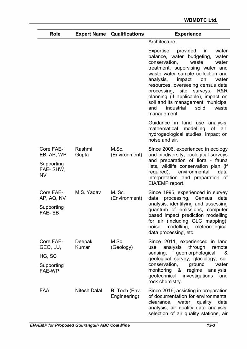
WBMDTC Ltd.
EIA/EMP for Proposed Gourangdih ABC Coal Mine 13-3
Role Expert Name Qualifications Experience
Architecture.
Expertise provided in water balance, water budgeting, water conservation, waste water treatment, supervising water and waste water sample collection and analysis, impact on water resources, overseeing census data processing, site surveys, R&R planning (if applicable), impact on soil and its management, municipal and industrial solid waste management.
Guidance in land use analysis, mathematical modelling of air, hydrogeological studies, impact on noise and air.
Core FAE- EB, AP, WP
Supporting FAE- SHW, NV
Rashmi Gupta
M.Sc. (Environment)
Since 2006, experienced in ecology and biodiversity, ecological surveys and preparation of flora - fauna lists, wildlife conservation plan (if required), environmental data interpretation and preparation of EIA/EMP report.
Core FAE- AP, AQ, NV
Supporting FAE- EB
M.S. Yadav M. Sc. (Environment)
Since 1995, experienced in survey data processing, Census data analysis, identifying and assessing quantum of emissions, computer based impact prediction modelling for air (including GLC mapping), noise modelling, meteorological data processing, etc.
Core FAE- GEO, LU,
HG, SC
Supporting FAE-WP
Deepak Kumar
M.Sc. (Geology)
Since 2011, experienced in land use analysis through remote sensing, geomorphological & geological survey, glaciology, soil conservation, ground water monitoring & regime analysis, geotechnical investigations and rock chemistry.
FAA Nitesh Dalal B. Tech (Env. Engineering)
Since 2016, assisting in preparation of documentation for environmental clearance, water quality data analysis, air quality data analysis, selection of air quality stations, air
WBMDTC Ltd.
EIA/EMP for Proposed Gourangdih ABC Coal Mine 13-4
Role Expert Name Qualifications Experience
quality modelling, water resource calculations, coordination with laboratory, etc.
FAA Pappu Kumar B. Tech (Hons.) (Env. Engineering)
Since 2017, assisting in preparation of documentation for environmental clearance, water quality data analysis, air quality data analysis, etc.
As per Circular no. F. No. J-11013/77/2004-IA II (I), dated 30th September
2011 of MoEF&CC, Min Mec is listed at serial no. 7 in List ‘B. Min Mec is preparing and presenting reports as per the High Court of Delhi orders dated 03.02.2014 (and subsequent) in LPA 110/2014 and CM No.2175/2014 (stay) and order dated 03.05.2016 (and subsequent) in W.P.(C) 3665/2016 (Copy given in Annexure XXV).
Others consultants
1. M/s Min Mec R&D Laboratory has collected baseline data through primary surveys for air quality, water quality, soil quality and noise levels. The laboratory is accredited by NABL (Certificate No. T-6337 valid till 07.10.2019).
2. The approved Revised Mining Plan (in April 2011) and Mine Closure Plan (in May 2011) for Gourangdih ABC Coal Block OCP by RQP Subhash Chandra Chatterjee.