Embed Size (px)
Citation preview

UNITED NATIONS NATIONS UNIES Организация Объединенных Наций أألمم المتحدة
联合国 NACIONES UNIDAS
OFFICE OF UN RESIDENT AND HUMANITARIAN CO-ORDINATOR FOR THE SUDAN
P.O. Box 913, 11111, Khartoum, SUDAN. Tel.: (249) 183-773-121 Fax: (249) 183-783826 www.unsudanig.org
Darfur Humanitarian Profile No. 4
01 July 2004
Next update: the first week of August 2004

[_
SAUDIARABIA
DRC
EGYPT
ETHIOPIA
LIBYA
CHAD
KENYA
UGANDA
CENTRAL AFRICAN REPUBLIC
ERITREA
Northern
Nile
North Darfur
Red Sea
Jongley
North Kordofan
South Darfur
West Kordofan
Gadaref
Upper Nile
Unity
Kassala
Warab
Sennar
West Equatoria
South Kordofan
West Darfur
East Equatoria
West Bahr Al Ghazal
Blue Nile
White Nile
Al Buhairat
Bahr Al Jabal
Al Jazeera
Khartoum
North Bahr Al Ghazal
Red S
ea
[_ KhartoumState BoundaryInternational Boundary
±
0 150 300 450 60075Kilometers
The boundaries and names shown and the designations used on this map do not imply official endorsement or acceptance by the Government of Sudan or the United Nations
Prepared & Compiled by HIC-DarfurData Source: DCW, OCHA, UNMASPrinted 09-July-04Cat. No.: SU-03
HIC for [email protected] 7, Block 5, Gama AvenueP.O. Box 913, KhartoumSudan
Sudan

!(
!(
!(
!(
!(
!(
!(
!(
!(
!(
!(
!(
!(
!(
!(
!(
!(
!(
!(
!(
!(
!(
!.
!(
!(
!(
!(
!(
!(
!(
!(
!(
!(
!(
!.
"/
"/
!(
!(
!(
!(
!(
!(
!(
!(
!(
!(
!(
!(
!(
!(
!(
!(
!(
!.
!(
!(
!(
!(
!(
!(
!(
!.
!(
!(
!(
!(
!.
!(
!(
!(
!(
!(
!(
!(
!(
!(
!(
!(
!(
!.!(
!(
!(
!(
!(
!(!(
!(
!.
!(
!(
!(
!(
!(
!(
!(
!(
!(
"/
!(
!(
!(
!(
!(
!.
!(
!(
!(
!(
!(
!(
!(
!(
!(
!(
!(
!(
!(
!(
!(
!(
!(
!(
!(
!(
!(
!(
!(
!(
!(
!(
!(
!(
!.
!(
!(
!(
!(
!(
!(
!(
!(
!(
!(
!(
!.
!(
!(
!(
!(
!(
!(
!(
!(
!(
!(
!(
!(
!(
!.
!(
!(
!(
!(
!(
!(
P
P
P
P
P
P
P
P
P
P P
P
P
P
P
P
PP
P
P
P
P
PP
P
PP P
P
P
P
P
PP
PP
PP
P
P
P
PP
P
P
P
P
P
P
PP
PP
P
P
P
P
P
P
P
P
P
P
P
P PP
P
PP
P
P
P
P
P
P
P
P
P
P
P
P PP
P P
PPP
P P
P
P
P
P
P
P
P
P
P
P
P
P
P
PP
P
PP
P
P
P
P
P
PP
P
PP
PP
P
P
PPP P
P
P
P
P
PP
Mellit
Kutum
Buram
Tina
Ad Daein
Adilla
El Fasher
Nyala
Um Kadadah
Shareia
Kabkabiya
Wadi SalihMukjar
Kulbus
Tulus
Edd Al Fursan
Al Geneina
Jebel Marra
Reheid Al Birdi
Zalllingi
Habillah
Kass
Nyala
El Fasher
El Geneina
Tulus
Kutum
Buram
Mellit
Zalingei
Ed Da`ein
KabkabiyyaUmm Kaddadah
Abyad
OgrYoyo
Vulu
Tulu
Tina
Suni
Kore
Kawm
Duma
Diri
Dilu
Dibs
Anka
Ulang
Tumko
Tomat
Tabur
Sullu
Songo
Sirri
Sibdu
Sabun
Sa`at
Radom
Nurei
Miski
Kulme
Kubbi
Kosua
Korei
Kaira
Jidad
Harun
Hajar
Guldo
Gelli
Galgi
Gabir
Dango
Babil
Ararah
Kornoi
Zarafi
Wajage
Turrah
Titini
Sheiga
Sayyah
Saheib
Safaha
Qumqum
Murnei
MogaraMa'mun
Kuwayn
Kubbum
Khamis
Keikei
Jefawa
Hagala
Gabras
Fagagh
Dambar
Burush
Burbur
Bukhit
`Abata
Girgira
Wada`ah
Um Buru
Timassi
Tawilah
Shuwayy
Nyimeri
Marmedi
Manasis
Khandaq
Karraro
Gartaga
Garsila
As Saqr
Al Faei
Umm Boim
Tumbruku
Taziriba
Shalasha
Mumallah
Misterei
Melmelli
MarlengaMarkundi
Kereinik
Kangalla
Hashabah
Hashabah
Furaywah
Fiabuggu
Duraysah
Duraysah
Betbetti
Beringil
Al Malwi
Uraydimah
Umm Siado
Umm Sarir
Umm Hijar
Umm Danga
Qawz Baya
Ligeidiba
Kulaykili
Gueighrin
Goweighin
Ghannamah
As Sumayh
Angarbaka
Al Hillah
Wad Hassib
Umm Shanqa
Umm Kitrah
Menawashei
Gami Filli
Gad es Sid
Chero Kasi
Amar Gedid
Abu Sufyan
Abu Jabrah
Umm Rukubah
Umm Habilah
Muhajiriyah
Malha Wells
Kafia Kingi
Ash Shuwayb
Abu Matariq
Abu KarinkaAbu `Ajurah
Umm Kutayrah
Birkat Saira
At Tuwayshah
`Amara Gedid
Far` al Habil
Shaqq al Gawad
Umm Digulgulaya
Shaqq al Khadir
Umm Gullah Hajar
Sigeir Umm Sa`una
The boundaries and names shown and the designations used on this map do not imply official endorsement or acceptance by the Government of Sudan or the United Nations
[_KHARTOUM
±
Prepared & Compiled by HIC-DarfurData on IDPs from OCHA, WFP-VAM UnitData on Boundary, Populated Places from NIMA, UNMASPrinted 9-July-04Cat. No.: SU-04
CHAD
CENTRAL AFRICANREPUBLIC
NORTH DARFUR
SOUTH DARFUR
WESTDARFUR
HIC for [email protected] 7, Block 5, Gama AvenueP.O. Box 913, KhartoumSudan
0 50 100 150 20025Kilometers
Populated Places
"/ State Capital
!. Major Location
!( Village
P IDP Concentration
RoadsState BoundaryLocality Boundary
International Boundary
DARFUR: IDP Concentrations

Darfur Humanitarian Profile - July 2004 2
Executive Summary Over one million internally displaced persons (IDPs) are estimated in the western Sudan region of Darfur with 225,493 in South Darfur, 324,215 in North Darfur and 500,748 in West Darfur. Including the affected host community of 203,584 people, the total number of conflict-affected accounted for in this document is estimated at 1,260,421. An additional significant number of the population, who are neither IDPs nor part of the host community have been affected by the conflict. This number is not known, but estimated at more than two million people including IDPs and host communities. In June, it is estimated that 52% of the conflict-affected population were provided with food, 54% of IDPs received NFI/shelter assistance, 38% of the conflict affected population have clean water, 13% of IDPs are covered by sanitation interventions, and primary health care facilities cover 37% of the conflict-affected population. Secondary health care facilities are available for 16% of the conflict-affected population, and an emergency measles campaign, which pre-empted the routine expanded program on immunization (EPI) schedule, covered 88% of all children between the ages of 9 months and 15 years. Protection and security remain the main concerns of IDPs. Despite the signing of a ceasefire agreement on 8 April, the parties to the conflict continue to fight, and Janjaweed militias continue to attack and loot villages throughout the Darfurs. Introduction
1. The Darfur Humanitarian Profile is a ‘living document’ that aims to provide as
comprehensive an overview as possible of the number and locations of IDPs and other people affected by the recent conflict in Darfur at a specific point in time, and a description of the current humanitarian agency presence in the region. This document aims to provide the most recent information and data available from the field. Most importantly, however, the Humanitarian Profile aims to clearly outline the needs and gaps as of 1 July 2004 in key sectors such as food, shelter, clean water, sanitation, primary health care facilities, basic drug supplies, secondary health facilities, and EPI.1 As such it is a benchmark for assessing the overall humanitarian situation in Darfur and the adequacy of the current humanitarian response. It is additionally used for contingency/program planning, advocacy and resource mobilization.2 A necessary caveat is that protection remains the IDPs foremost priority and lack of security continues to impact the humanitarian assistance program throughout the Darfur region.
2. The Profile consists of a narrative overview of the region including charts and maps
providing key figures for each Darfur state regarding numbers of IDPs and affected people and gaps in each humanitarian sector provided both for the affected population as a whole and for those that are accessible to the United Nations security standards. The overall analysis of the humanitarian situation is complemented with information on access and protection issues. In addition, there is a specific overview on each Darfur state. A one-page matrix on each IDP location
1 Additional sectors include nutrition, agriculture, education, protection and camp management. 2 The 90-Day Humanitarian Action Plan for Darfur is the framework of immediate response to the humanitarian situation outlined by UN agencies and NGOs over a period from 1 June to 31 August 2004. Both the 90-Day Plan and the Funding Overview for the Darfur Crisis – a resource-tracking document - can be found at www.unsudanig.org.

Darfur Humanitarian Profile - July 2004 3
is included in the annexes and includes details on current response, pipeline issues, and action points for the specific location.
Methodology 3. The one-page matrices for each IDP location have been filled in at the field level, in
cooperation with humanitarian agencies on the ground as well as state Governments. A number of charts and maps based on the Darfur-wide tables are then produced along with a narrative description of the findings. The draft Profile is circulated to all UN agencies in Khartoum for comments and corrections. The Profile is updated on a monthly basis and placed on the internet (www.unsudanig.org). Appropriately trained OCHA staff in each of the three Darfur state capitals and a dedicated OCHA information officer in Khartoum facilitate the process.
4. Each of the three Darfur states are administratively divided into a number of
Localities sub-divided into Administrative Units, which are further sub-divided into Village Councils, consisting of a number of villages and stand alone locations of IDPs. The administrative boundaries and exact location of IDP settlements in Darfur are under review for proper placement on accompanying maps.
5. The information in the Humanitarian Profile is collected based on a comprehensive
list of principles and assumptions, which can be found at the end of this document. Although achievement of Sphere standards is the ultimate goal, different assumptions are used for some sectors given the emergency circumstances. These assumptions have been agreed by humanitarian agencies working in Darfur since the Humanitarian Profile project was first launched in September 2003. Given the demanding operational environment, the fluidity of the situation on the ground and difficulty of obtaining and verifying information, the Profile represents only our best understanding of the situation as of 1 July 2004.
6. The gaps indicated in the Profile are set against providing all identified IDPs and
conflict affected people with basic services, although it is recognized that the human development indicators for Sudan as a whole, show that even in peaceful regions of the Sudan the basic human needs of a significant proportion of the population remain unfulfilled.3 Nevertheless, full coverage must remain the target of humanitarian interventions in Darfur given the extreme vulnerability of its conflict affected population who are generally living in extremely crowded conditions, having lost all sources of livelihood, and prone to various potentially fatal diseases. As a result vulnerability is not at a static level, but is at risk of seriously deteriorating further. In addition, continued attacks and insecurity despite the cease-fire agreement means that people remain fearful of returning to their homes and, in some cases, of even accepting humanitarian materials such as shelter, due to further anticipated looting and harassment by militias.
7. The Humanitarian Profile focuses solely on immediate humanitarian needs. Brief
references are made in some matrices to assistance provided to agriculture and education as part of the emergency response effort. In general, however,
3 According to the Human Development Report 2003, Sudan’s HDI is 138 of 175; it is 52 among 94 developing countries on the Human Poverty Index; life expectancy at birth is 55.4 (66.7 world average); 75% of the population have access to an improved water source; and 62% of the population have access to improved sanitation.

Darfur Humanitarian Profile - July 2004 4
substantive recovery and rehabilitation issues need to be addressed outside of this document once a substantiated peace has returned to the Greater Darfur Region.
Please address any comments to the UN Darfur Coordination and Information Cell, OCHA - Khartoum:
Mike McDonagh, Manager Jessica Bowers, Information Officer Office: +249 (0) 183773121 ext.329 Office: +249 (0) 183773121 ext. 360 Mobile: +249 (0) 912 306469 Mobile: +249 (0) 912 160066 Email: [email protected] Email: [email protected]
Situational Overview Conflict affected population 1. The international response to the Darfur crisis has increased considerably in the
past month. The UN Secretary-General, Kofi Annan, and the US Secretary of State, Colin Powell, made separate visits to Sudan and the Darfur region 29 June – 2 July. Following the visits, the UN and Government of Sudan (GoS) issued a joint communiqué on 3 July which stated that the bureaucratic regulations impeding the rapid scaling up of humanitarian assistance in the Darfur region would be lifted, that human rights violations would be investigated including with the deployment of human rights monitors and that there would be a political solution to the conflict.
2. A donors conference attended by key humanitarian agencies, donors, GoS officials
and SLA and JEM rebel groups was held on 3 June in Geneva. This resulted in additional support and disbursements for the crisis though many agencies still have less than half the funding needed to support their programs. Additionally, the 90-Day Humanitarian Action Plan for Darfur, prepared by UN agencies and NGOs and currently covering the period from 1 June to 31 August 2004, was launched as the main tool to ensure an effective, coordinated response to the humanitarian needs. While some progress is being made in meeting the needs of people in the big concentration areas of IDPs across all sectors, the situation of people in the camps is still extremely poor, necessitating increased capacity and humanitarian response. IOM, in cooperation with OCHA, is carrying out a comprehensive assessment of camp management priorities. The results of this assessment will contribute to the better allocation of responsibilities and define roles for this sector. As security and protection remain priority issues for IDPs, humanitarian agencies should increase their capacity and capability through the provision of experienced international staff.
3. Due to the increasing international attention on the conflict and the increasing
severity of the humanitarian crisis, GoS restrictions on humanitarian access have considerably eased during the month. UN and other operational agencies have also increased their presence to better respond to the crisis, however, only around 322 international staff (169 on 1 June) currently work in the Darfur region, compared to the projected 800 -1,000 international staff needed to provide aid and protection assistance to the conflict-affected population.
4. Increasing insecurity throughout the region has also been an impediment to
humanitarian assistance. New rounds of fighting between the parties and raids by the Janjaweed are among the security concerns of IDPs and humanitarian staff. The number of checkpoints erected on some strategic routes by both the SLA and GoS in all the three Darfur states has increased and prevented the smooth operation of humanitarian traffic. Additionally, several security incidents involving clearly marked
Darfur Humanitarian Profile - July 2004 5
humanitarian convoys reported during the past month triggered increasing concerns about the safety and overall security situation in the region.
5. The scale and impact of the crisis on the civilian population in Darfur continues to
rise. The vast majority of the IDP populations maintain that they are not ready to return to their areas of origin until increased security is provided at return locations. Many IDPs coming in from rural areas and recent arrivals from locations not yet reached by humanitarian assistance report continued harassment and violence. The African Union (AU) is sending ceasefire monitors throughout the region. However, only a small number of observers are in North Darfur and had by 1 July not yet started their operations.
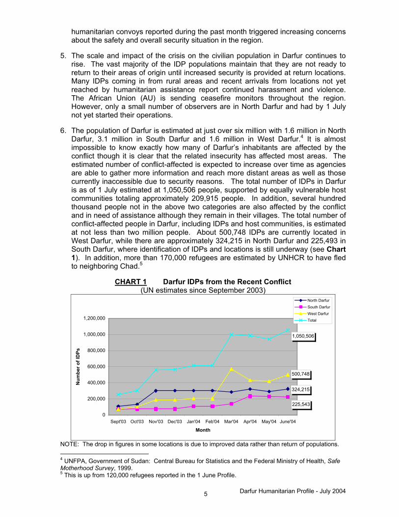
6. The population of Darfur is estimated at just over six million with 1.6 million in North
Darfur, 3.1 million in South Darfur and 1.6 million in West Darfur.4 It is almost impossible to know exactly how many of Darfur’s inhabitants are affected by the conflict though it is clear that the related insecurity has affected most areas. The estimated number of conflict-affected is expected to increase over time as agencies are able to gather more information and reach more distant areas as well as those currently inaccessible due to security reasons. The total number of IDPs in Darfur is as of 1 July estimated at 1,050,506 people, supported by equally vulnerable host communities totaling approximately 209,915 people. In addition, several hundred thousand people not in the above two categories are also affected by the conflict and in need of assistance although they remain in their villages. The total number of conflict-affected people in Darfur, including IDPs and host communities, is estimated at not less than two million people. About 500,748 IDPs are currently located in West Darfur, while there are approximately 324,215 in North Darfur and 225,493 in South Darfur, where identification of IDPs and locations is still underway (see Chart 1). In addition, more than 170,000 refugees are estimated by UNHCR to have fled to neighboring Chad.5
CHART 1 Darfur IDPs from the Recent Conflict
(UN estimates since September 2003)
324,215
225,543
500,748
1,050,506
0
200,000
400,000
600,000
800,000
1,000,000
1,200,000
Sept'03 Oct'03 Nov'03 Dec'03 Jan'04 Feb'04 Mar'04 Apr'04 May'04 June'04
Month
Num
ber o
f ID
Ps
North Darfur
South DarfurWest DarfurTotal
NOTE: The drop in figures in some locations is due to improved data rather than return of populations. 4 UNFPA, Government of Sudan: Central Bureau for Statistics and the Federal Ministry of Health, Safe Motherhood Survey, 1999. 5 This is up from 120,000 refugees reported in the 1 June Profile.

Darfur Humanitarian Profile - July 2004 6
7. IDPs and those hosting them are easier to identify than other populations since
IDPs tend to gather in a limited number of locations. For this reason, only those conflict affected people that are either IDPs or residents in areas hosting IDPs are included in this Profile as seen in Chart 2. In areas where IDPs congregate, the total number of displaced is often many times that of permanent residents. This is however not the case in the three state capitals; the host communities there are thus not included in the Profile, although it is estimated that these host communities are also increasingly affected by the crisis. It should also be noted that of the 200,000 Dinka IDPs from Bahr-el-Ghazal state in Southern Sudan that were estimated to be living in South Darfur at the beginning of the recent Darfur crisis, only those affected by this recent conflict through further displacement or looting (since March 2003) are included in the Profile.
CHART 2 Estimated Number of Conflict Affected Population
(IDPs and Host Communities)
�
Total: 1,260,421 North: 397,707 South: 259,224 West: 603,490
1,050,506
324,215 225,493
500,748
209,915
73,49233,681
102,742
0
200000
400000
600000
800000
1000000
1200000
1400000
Total North South WestDarfur State
Number of People
Host CommunitiesIDPs
Accessible population 8. Accessible areas are those defined as locations where the GoS can guarantee
security for UN staff. The UN System classifies areas in two terms, "GO and NO GO". The classification is carried out by the UN system in accordance with relevant security rules, regulations and procedures, including prevailing conditions in areas of concern. Chart 3 indicates the proportion of the conflict-affected people that are currently accessible according to the UN. The figure for Darfur as a whole is 90% (86% for North Darfur, 85% for South Darfur and 100% for West Darfur), meaning that 1,134,233 conflict-affected people are located in areas that are accessible according to UN security standards. These figures give a general idea of the number of people that can be assisted, although it does not present an entirely accurate picture for three reasons:
• Although many NGOs tend to follow UN security standards, some NGOs will go to areas even if the United Nations considers them "NO GO" areas;
• Access does not mean that humanitarian assistance is being delivered; and

Darfur Humanitarian Profile - July 2004 7
• Humanitarian assistance is not being provided to SLA-held areas at this time.
CHART 3 Estimated Number of People Accessible According to UN Security Standards
People assisted and remaining gaps 9. The target population for most sectors is the total conflict affected population,
including IDPs and host communities, while only IDPs are targeted for the provision of shelter material and sanitation as it is assumed that the host communities already have access to sanitation at a level that does not require additional emergency intervention. Children aged six to thirteen years (estimated at 22% of the total population) are the target population for education. For nutrition the target is the number of malnourished children under five receiving either therapeutic or supplementary feeding, estimated at 1/5 of 17% of the target population. An emergency measles campaign which pre-empted the routine EPI schedule for the month of June had a target population of all children nine months to fifteen years, estimated at 41% of the total population. Measles, normal even under peaceful conditions in Darfur, is a major concern because of the cramped conditions in which IDPs live. Agencies may continue to focus on the emergency measles vaccinations in July though primary health care units are being encouraged to consider a wider campaign of EPI coverage.
10. Chart 4 indicates the extent to which the needs of the conflict-affected population
have been met and the remaining gaps in each sector. It is thus indicated that an estimated 48% of the conflict-affected population currently does not have access to food assistance (49% on 1 June). WFP, ICRC and various other NGO food pipelines provided an estimated 650,198 beneficiaries food assistance. WFP had initially planned to cover 800,000 IDPs in June but was hindered by capacity constraints, pipeline delays, insecurity and logistical difficulties. Continuing movement of the population and poorly prepared and verified government IDP lists, have further delayed the food distribution process.
100%
85%86%
90%
15%14%
10%
0
200000
400000
600000
800000
1000000
1200000
1400000
Total North South West Darfur State
Num
ber o
f peo
ple
Not AccessibleAccessible

Darfur Humanitarian Profile - July 2004 8
CHART 4 Estimated Sectoral Needs and Gaps in Greater Darfur
88%16%37%38%52% 54%13% 39%
11%84%61%63%
87%
48%46% 62%
0
200000
400000
600000
800000
1000000
1200000
1400000
Food Shelter Cleanwater
Sanitation PrimaryHealthCare
Facilities
Basic DrugSupplies
SecondaryHealthCare
Facilities
EPI(measles
campaign)
Sector
Targ
et P
opul
atio
n
Assisted Gap
NOTE: The figures given for EPI (measles campaign) reflect only measles vaccinations provided to the target population as of 1 July and not full EPI coverage. 11. There is a 46% gap in the provision of shelter material (88% on 1 June) and a 62%
gap in the provision of clean water (67% on 1 June). Chart 5, provided by UNJLC, details the current stock of shelter and NFIs on the ground as a percent of the total requirement. The current shelter options in spontaneous settlements throughout Darfur provide insufficient protection from the weather conditions and the desert environment with its extreme temperatures. Further, the rainy season started on schedule in mid-June (see map: Accessibility During Rainy Season). Agencies believe that in a matter of weeks, the rains will have rendered some roads impassable to delivery of humanitarian assistance and transformed crowded and unsanitary displacement sites into breeding grounds for communicable diseases such as watery diarrhea, measles, meningitis, and malaria.
CHART 5 Current Stock of Shelter and NFIs
Cummulative Total Distributed as % of Requirement Cummulative Total En-Route+Received as % of Requirement
0% 10% 20% 30% 40% 50% 60% 70% 80% 90% 100%
Blankets
Plastic Sheet 4 X 5 M
Soap
Jerrycan 10l - 20l
Cooking pot
Mosquito Nets
Sanitary material ("red flanel")
Bucket with lid, 20l
Clothing ("zentingi")
Series1Series2

!(
!(
!(
!(
!(
!(
!(
!(
!(
!(
!(
!(
!(
!(
!(
!(
!(
!(
!(
!(
!(
!(
!.
!(
!(
!(
!(
!(
!(
!(
!(
!(
!(
!(
!.
"/
"/
!(
!(
!(
!(
!(
!(
!(
!(
!(
!(
!(
!(
!(
!(
!(
!(
!(
!.
!(
!(
!(
!(
!(
!(
!(
!.
!(
!(
!(
!(
!.
!(
!(
!(
!(
!(
!(
!(
!(
!(
!(
!(
!(
!.!(
!(
!(
!(
!(
!(!(
!(
!.
!(
!(
!(
!(
!(
!(
!(
!(
!(
"/
!(
!(
!(
!(
!(
!.
!(
!(
!(
!(
!(
!(
!(
!(
!(
!(
!(
!(
!(
!(
!(
!(
!(
!(
!(
!(
!(
!(
!(
!(
!(
!(
!(
!(
!.
!(
!(
!(
!(
!(
!(
!(
!(
!(
!(
!(
!.
!(
!(
!(
!(
!(
!(
!(
!(
!(
!(
!(
!(
!(
!.
!(
!(
!(
!(
!(
!(
P
P
P
P
P
P
P
P
P
P P
P
P
P
P
P
PP
P
P
P
P
PP
P
PPP
P
P
P
P
PP
PP
PP
P
P
P
PP
P
P
P
P
P
P
PP
PP
P
P
P
P
P
P
P
P
P
P
P
P PP
P
P
P
P
P
P
P
P
P
P
P
P
P
P
P P
P
P P
PPP
P
P
P
P
P
P
P
P
P
P
P
P
P
P
P
PP
P
PP
P
P
P
P
P
P
P
P
PP
PP
P
P
PPP P
P
P
P
P
Nyala
El Fasher
El Geneina
Kas
Tulus
Kutum
Buram
Mellit
Habilah
Zalingei
Ed Da`ein
KabkabiyyaUmm Kaddadah
Rihed Al Birdi
Abyad
OgrYoyo
Vulu
Tulu
Tina
Suni
Kore
Kawm
Duma
Diri
Dilu
Dibs
Anka
Ulang
Tumko
Tomat
Tabur
Sullu
Songo
Sirri
Sibdu
Sabun
Sa`at
Radom
Nurei
Miski
Kulme
Kubbi
Kosua
Korei
Kaira
Jidad
Harun
Hajar
Guldo
Gelli
Galgi
Gabir
Dango
Babil
Ararah
Kornoi
Wajage
Turrah
Titini
Sayyah
Saheib
Safaha
Qumqum
Murnei
MogaraMa'mun
Kuwayn
Kubbum
Khamis
Keikei
Jefawa
Hagala
Gabras
Fagagh
Dambar
Burush
Burbur
Bukhit
`Abata
Girgira
Wada`ah
Um Buru
Timassi
Tawilah
Shuwayy
Nyimeri
Marmedi
Manasis
Khandaq
Karraro
Gartaga
Garsila
As Saqr
Al Faei
Umm Boim
Tumbruku
Taziriba
Shalasha
Mumallah
Misterei
Melmelli
Marlenga
Markundi
Kereinik
Kangalla
Hashabah
Hashabah
Furaywah
Fongfong
Fiabuggu
Duraysah
Duraysah
Betbetti
Beringil
Al Malwi
Uraydimah
Umm Siado
Umm Sarir
Umm Hijar
Umm Danga
Shergeila
Qawz Baya
Ligeidiba
Kulaykili
Gueighrin
Goweighin
Ghannamah
As Sumayh
Angarbaka
Al Hillah
Wad Hassib
Umm Shanqa
Umm Kurdus
Umm Kitrah
Tandubayah
Menawashei
Gami Filli
Gad es Sid
Chero Kasi
Amar Gedid
Abu Sufyan
Abu Jabrah
Umm Rukubah
Umm Habilah
Muhajiriyah
Malha Wells
Kafia Kingi
Ash Shuwayb
Abu Matariq
Abu KarinkaAbu `Ajurah
Zulumingtong
Zarqa Hadida
Umm Kutayrah
Saq an Na`am
Birkat Saira
At Tuwayshah
`Amara Gedid
Tabbi Nyebbei
Far` al Habil
Shaqq al Gawad
Umm Digulgulaya
Shaqq al Khadir
Umm Gullah Hajar
Sigeir Umm Sa`una
[_Khartoum
±
0 50 100 15025Kilometers
Darfur: Accessibility During Rainy Season (June - September)
CHAD
CENTRAL AFRICANREPUBLIC
Populated Places
"/ State Capital
!. Major Location
!( Village
P IDP Concentration
Roads
River / Stream
Water body
State Boundary
International Boundary
Areas accessible throughout the rainy season
Areas not accessible from June to September
Areas either partially accessible (2 - 6 days with no access after heavy rainfall) or no information available
NORTH DARFUR
SOUTH DARFUR
WESTDARFUR
The boundaries and names shown and the designations used on this map do not imply official endorsement or acceptance by the Government of Sudan or the United Nations
Prepared & Compiled by HIC-DarfurData on Accessibility from WFPData on IDPs from WFP, OCHAData on Boundary, Populated Places from UNMAS, NIMAPrinted 9-July-04Cat. No.: SU-02
HIC for [email protected] 7, Block 5, Gama AvenueP.O. Box 913, KhartoumSudan
VAM Unit, WFP-Sudan

Darfur Humanitarian Profile - July 2004 9
12. The sanitation gap is estimated at 87% (93% on 1 June). The lack of sanitation in the crowded IDP concentration areas is a major health hazard, especially given the rainy season. Outbreaks of communicable diseases such as watery and bloody diarrhea have been reported in some large IDP concentrations, such as Abu Shouk in El Fasher.
13. The gap in access to primary health care facilities is estimated at 63% (57% on 1
June) and 84% (94% on 1 June) in access to secondary health care while the gap in the provision of basic drug supplies is estimated at 61% (48% on 1 June).
14. Chart 6 similarly provides an overview of gaps, but this time as a percentage of the
population accessible according to UN security standards. The gaps (food 45%, shelter 43%, water 61%, sanitation 86%, primary health facilities 60%, basic drugs 58%, and secondary health facilities 83%) are similar to those on Chart 5, and a cause for concern.
CHART 6 Estimated Sectoral Needs and Gaps in Areas Accessible by UN
�
39%55% 57% 14% 40% 42% 17%
92%
86%45%
43% 61% 60% 58% 83%9%
0
200000
400000
600000
800000
1000000
1200000
1400000
Food Shelter Cleanwater
Sanitation PrimaryHealthCare
Facilities
Basic DrugSupplies
SecondaryHealthCare
Facilities
EPI(measles
campaign)
Sector
Targ
et p
opul
atio
n
GapAssisted
NOTE: The figures given for EPI (measles campaign) reflect only measles vaccinations provided to the target population as of 1 July and not full EPI coverage. 15. There are currently around thirty international NGOs and UN agencies operational
in the Darfurs and an additional ten agencies are in the process of starting operations. Among the new NGOs, World Vision, Solidarites, Merlin, Tearfund, Catholic Relief Services (CRS), Intersos, and Triangle are setting up in South and West Darfur, and American Refugee Committee, Danish Refugee Council, Mercy Corps, and are in the process of registering with the GoS.
16. Chart 7 indicates that not only the number of agencies is limited, but also that the
number of staff employed is insufficient in comparison with the scale of the crisis. The total number of UN and INGO staff in Greater Darfur is 322 international to 1,721 national (program and project staff only) compared to 169 and 1,139, respectively, as of 1 June. This means that there is roughly only one international staff per 3300 IDPs and one national staff per 610 IDPs. While there is no international standard in emergency situations regarding the number of humanitarian staff required, it is estimated that sufficient coverage would be 800-

Darfur Humanitarian Profile - July 2004 10
1000 trained, experienced international personnel given the assistance required in all sectors. This ratio becomes even more extreme when compared to the overall number of conflicted affected people in Darfur and the likely increase in that number over the coming months. See the Annexes for a complete listing of humanitarian agency presence and sector coverage in the individual states.
CHART 7 Total Number of Humanitarian Staff Working in Darfur States
107102113322
717366638
1721
0
500
1000
1500
2000
2500
Total North South West
State
Num
ber
International National
17. Chart 8 provides a breakdown of UN and NGO staff working in each Darfur state.
CHART 8 Number of Humanitarian Staff Working in each Darfur State
2489
2874
2681
29
609
36
330
23
694
0
100
200
300
400
500
600
700
800
UN INGOs UN INGOs UN INGOs
NORTH SOUTH WEST
States
Num
ber
International National
18. Much work has been done across Darfur, as can be seen above. However,
discussions continue between the Government of Sudan, UN agencies, NGOs, and

Darfur Humanitarian Profile - July 2004 11
the donor community to satisfy the clear deficiencies faced in the region. Increasing the staff, equipment, and funding for the crisis is of utmost importance to defining a protection-oriented policy of assistance, increasing the quality and pertinence of assessments, enhancing delivery and implementation capacity, and improving monitoring capabilities.
State Specific Overviews Specific overviews on the three Darfur states are provided for an in-depth focus on the current situation and pending needs faced in each location.
NORTH DARFUR North Darfur faces a severe emergency with the estimated 397,707 war-affected people of which 324,215 are known / verified IDPs requiring emergency humanitarian assistance. The number of IDPs in large concentrations has steadily increased with continued insecurity and the onset of the rainy season. Lack of protection has prevented people from relocating to their villages at the crucial planting season. Violence, coercion and deprivation as well as killings, rapes and harassments are everyday experiences for IDPs in and around Kebkabiya and Kutum. Recently, some IDPs in Tawilla and Korma have indicated their interest in returning to their villages to cater to their farmland, however, security and protection has remained their primary concern and has thus prevented them moving. Further, prior to the visit of UN Secretary-General on 1 July, the GoS and a local NGO moved 680 IDP households from El Meshtal to Abu Shouk camp overnight without consultation and preplanning with humanitarian agencies. Humanitarian interventions are largely confined to urban areas and four camp settings due to limited access and security concerns. Unless and until scattered displacements in hills, bush and wadi’s are assessed and assisted it is impossible to accurately estimate humanitarian gaps and needs. Three major geographical areas are in urgent need of an inter-agency assessment including 1) the area between and North of Kutum and Mellit, 2) Tina, Kornoi and Um Barru and 3) Jebel Si. The forthcoming rainy season poses new challenges in terms of access, logistics, shelter and lack of farming activities. WFP reached 260,270 conflict-affected people with food assistance in June and has pre-positioned for the rainy season. WFP/SRCS have recently agreed to begin food distribution to IDPs in El Fasher town to avoid further migrations of IDPs from town to Abu Shouk camp. The distribution of NFIs through the common pipeline started on 1 July to IDPs in Kutum by GOAL. As of 28 June, North Darfur central shelter/NFI pipeline counts 40,050 on stock in the CARE warehouse. Additional blankets, plastic sheeting, buckets, jerry cans, and soap are expected over the coming two weeks. With the onset of the rainy season, outbreak of communicable diseases has become an area of concern; especially in camp settings. Migrations and relocations in crowded spaces have also increased the health hazards and risk of outbreaks. IRC operates a clinic at Abu Shouk camp and GOAL operates clinics in Kutum and Fata Borno. MSF-B are providing medical services in Kebkabiya hospital and planning to open another base of operation in Sarif Omra/Birkat Seira. IRC recently (28 June) found a high number of watery and bloody diarrheal cases in Abu Shouk camp. In response to a high number of diarrheal cases, ICRC, IRC and UNICEF have decided to quickly establish 25 ORS-distribution centers. In addition, on 1 July

!(
!(
!(
!(
!(
!(
!(
!(
!(
!(
!(
!(
!(
!(
!(
!(
!(
!(
!(
"/
"/
!(
!(
!(
!(
!(
!(
!(
!(
!(
!(
!(
!(
!(
!.
!(
!(
!(
!(
!.
!(
!(
!(
!.
!(
!(
!(
!(
!(
!(
!(
!(
!.!(
!(
!(
!(
!.
!(
!(
!(
!(
!(
!(
!(
!(
"/ !(
!(
!(
!(
!(
!(
!(
!(
!(
!(
!(
!(
!(
!(
!(
!(
!(
!(
!(
!(
!(
!(
!(
!(
!(
!(
!(
!(
!(
!(
!.
!(
!(
!(
!(
!(
!(
!(
!(
!(
!(
!(
!.
!(
!(
!(
!(
!(
!(
P
P
P
P
P
P
P
P
P
P P
P
P
P
P
P
PP
P
P
P
P
PP
P
PP P
P
P
P
P
PP
PP
PP
P
P
P
PP
P
P
P
P
P
P
PP
PP
P
P
P
P
P
P
P
P PP
P
P
P
P
P
P
P
PP
P
P
P
P P
P
P P
P P
P
P
P
P
P
P
P
P
P
P
PP
P
PP
P
P
P
PP
PP
P
P
PPP P
P
P
Mellit
Kutum
Tina
El Fasher
Um Kadadah
Shareia
Nyala
Kabkabiya
Kulbus
Wadi Salih
Al Geneina
Jebel Marra
ZalllingiHabillah
Mukjar
Adilla
Edd Al Fursan
Kass
Nyala
El Fasher
El Geneina
Kas
KutumMellit
Habilah
Zalingei
KabkabiyyaUmm Kaddadah
OgrYoyo
Tulu
Tina
Suni
Kore
Kawm
Duma
Diri
Dilu
Anka
Ulang
Tumko
Sullu
Sirri
Sabun
Sa`at
Nurei
Miski
Kulme
Korei
Kaira
Harun
Guldo
Gelli
Galgi
Gabir
Babil
Ararah
Kornoi
Zarafi
Turrah
Titini
Sheiga
Sayyah
Saheib
Qumqum
Murnei
MogaraMa'mun
Kuwayn
Kubbum
Khamis
Keikei
Hagala
Fagagh
Burush
Burbur
`Abata
Girgira
Wada`ah
Um Buru
Tawilah
Shuwayy
Marmedi
Karraro
Gartaga
Garsila
Umm Boim
Taziriba
Misterei
Melmelli
Kereinik
Kangalla
Hashabah
Hashabah
Furaywah
Fongfong
Fiabuggu
Duraysah
Betbetti
Beringil
Uraydimah
Umm Siado
Umm Sarir
Qawz Baya
Ghannamah
Al Hillah
Wad Hassib
Umm Shanqa
Umm Kurdus
Umm Kitrah
Menawashei
Gami`Filli
Gad es Sid
Chero Kasi
Amar Gedid
Abu Sufyan
Umm Rukubah
Umm Habilah
Muhajiriyah
Malha Wells
Zulumingtong
Zarqa Hadida
Birkat Saira
At Tuwayshah
`Amara Gedid
Tabbi Nyebbei
Shaqq al Gawad
Shaqq al Khadir
Umm Gullah Hajar
Sigeir Umm Sa`una
Yara
Gulu
Thur
Limo
Sisi
Gorno
Barde
Nyama
Mailo
Kalma
Korma
Azoum
Beida
Sirba
Selah
Habuba
Areida
Rokero
El Dur
Yassin
Korole
Artala
Teisha
Deleij
Mellam
Mukjar
Tanako
Kulbus
Mashtel
Umajaja
Sandada
Zam Zam
Shaeria
Singita
Shataya
Kungara
Um Kher
Nertiti
Bindizi
Kondobe
Sanihaya
Abushouk
Hillilat
Mangarsa
Degoussa
Mershing
Daba Toga
ALMazroub
Um labasa
Umm Berro
Um Sayala
Eleikersha
Jabel Moon
Saraf Omra
Por Saieed
Fato Barno
Um Burongga
Dar El Salam
Abdel Shakor
Kanvo Haraza
Damrat Masry
Ardamata Camp
Shangil Tobayi
Garah Fargwiya
East Jebel Marra
Al Seraif Beni H
Damrt Elsheikh ACHAD
SOUTH DARFUR
WESTDARFUR
Populated Places
"/ State Capital
!. Major Location
!( Village
P IDP Concentration
RoadsLocality BoundaryState BoundaryInternational Boundary
NORTH DARFUR
0 25 50 7512.5Kilometers
[_Khartoum±
NORTH DARFUR: IDP Concentrations (30 June'04)
The boundaries and names shown and the designations used on this map do not imply official endorsement or acceptance by the Government of Sudan or the United Nations
Prepared & Compiled by HIC-DarfurData on IDPs from OCHA, WFP-VAM UnitData on Boundary, Populated Places, Roads from NIMA, OCHA, UNMAS, WFPPrinted 9-July-04Cat. No.: SU-06
HIC for [email protected] 7, Block 5, Gama AvenueP.O. Box 913, KhartoumSudan

Darfur Humanitarian Profile - July 2004 12
OXFAM launched a comprehensive work plan on responding to diarrhea outbreak in the camp.
Risk of extensive malnutrition and famine could easily become long-term effects of the emergency since only limited planting is observed at the onset of the rainy season. However, an ACF nutritional survey in Abu Shouk camp suggesting 39% global and 9.7% severe malnutrition has raised the profile of the sector. In response to these alarming findings, the agency has established a therapeutic feeding centre in the camp. Supplementary feeding and blanket distribution to children below 5 years has been agreed upon. In Kutum, GOAL operates a TFC and ACF operates a TFC in Kebkabiya hospital, which is administered by MSF-Belgium. SOUTH DARFUR
The ongoing humanitarian crisis showed little sign of abating in the month of June. IDP movement continued throughout the state, further frustrating humanitarian assistance efforts and causing increased concern regarding the security and protection of the population. Protection and security remain at the forefront of concerns by IDPs and humanitarian agencies. Active military engagements in the Ta’asha area, along the North-South Darfur state border, and in Sheriya locality added to the influx of IDPs into Nyala, Kalma, and Beliel camps, while IDPs continue a steady trickle into Kass, mainly for reasons of security and the possibility of humanitarian assistance. IDP populations, the Humanitarian Aid Commission (HAC), UNOCHA and UNHCR have been in discussion about voluntary relocation of IDPs in Kass. With the involvement of UNHCR and Norwegian Refugee Council (NRC) site planners, alternative sites have been identified. However, the overriding security concerns at the alternative sites have not been resolved because the promised presence of 60 police at the new sites have not materialized. Dinka IDPs have also been displaced due to renewed fighting between GoS troops and the SLA. Further, the systematic terrorisation of the IDP population by Arab militias continue including with rape, beatings, disappearances, and looting at nearly every IDP location in the area. The announcement made by the President of Sudan on 17 June that all outlaw groups, including the Janjaweed, would be disbanded and disarmed has yet to take effect in South Darfur. Agencies hope that the significant increase in international NGOs coming in with staff, equipment, and solid pipelines should provide a measure of protection and deliver the still much-needed humanitarian assistance to the population.
WFP, through implementing partners CARE, SRCS and SPCR reached 28% of the identified conflict-affected with food assistance in the month of June. FAO supplied seeds and agricultural tools to families in the Kass and Nyala hinterlands, as well as in the Ed Daein and Riyad al Berdi areas. In terms of non-food items and shelter, there has not been a large-scale distribution of the items and massive gaps remain across the state, however significant distributions have been carried out by ICRC in Kass and CARE in Kalma, with the provision of plastic sheeting, blankets, soap (ICRC), and jerry cans to 8,500 and 6,600 families, respectively.
Although for a number of IDPs access to clean water has improved, major unmet needs remain, particularly in high concentration areas such as Kalma and across localities in

!(
!(
!(
!(
!(
!(
!(
!(
!(
!(
!(
!(
!(
!(
!(
!(
!(
!.
!(
!(
!(
!(
!(
!(
!(
!(
!(
!.
!(
!(
!(
!(
!(
!(
!(
!(
!(
!(
!(
!(
!(
!.
!(
!(
!(
!(
!(
!(
!(
!.
!(
!(
!(
!(
!(
!(
!(
!(
!(
!(
!(
!(
!(
!(!(
!(
!(
!(
!(
!(
!(
"/
!(
!(
!(
!(
!.
!(
!(
!(
!(
!(
!(
!(
!(
!(
!(
!(
!(
!(
!(
!(
!(
!(
!(
!(
!(
!(
!.
!(
!(
!(
!(
!(
!(
!(
!(!(
!(
!(
!(
!(
!(
!(
!(
!(
!.
!(
!(
P
P
P
P
P
P
P
P
PP
P
PP
P
P
P
P
P
P
PP
P
P
P
P
P
P
P
P
P
P
P PP
P
P
P
P
P
P
P
P
P
P
P
P P
P P
PPP
P P
P
P
P
P
P
P
P
P
P
PP
P
P
P
P
PPP P
P
P
P
P
P
P
Nyala
Kas
Tulus
Buram
Habilah
Zalingei
Ed Da`ein
Rihed Al Birdi
Yara
Gulu
Thur
Limo
Sisi Gorno
Bilal
Nyama
Kirwa
Safia
Kalma
Azoum
Habuba
SharefAdilla
Yassin
Korole
Artala
Teisha
Deleij
Mellam
Mukjar
Tanako
Gereida
Al Gora
Shaeria
Singita
Hashaba
Shataya
Um Kher
Nertiti
Bindizi
Assalaya
Jimiaiza
Mangarsa
Degoussa
UmDukhan
Mershing
ALMazroub
Um labasa
El Ferdous
Abu Sellala
Dar El Salam
Foro Burunga
Sanam El Naga
Gemeiza Korma
Shangil Tobayi
Ghazala Jawazat
East Jebel Marra
Abyad
OgrYoyo
Vulu
Tulu
Suni
Kore
Duma
Diri
Dilu
Dibs
Tumko
Tomat
Tabur
Sullu
Songo
Sirri
Sibdu
Sabun
Sa`at
Radom
Nurei
Kulme
Kubbi
Kosua
Korei
Jidad
Harun
Hajar
Guldo
Gabir
Dango
Babil
Wajage
Titini
Saheib
Safaha
Murnei
MogaraMa'mun
Kubbum
Khamis
Keikei
Jefawa
Gabras
Fagagh
Dambar
Burbur
Bukhit
`Abata
Wada`ah
Timassi
Shuwayy
Nyimeri
Manasis
Khandaq
Karraro
Gartaga
Garsila
As Saqr
Al Faei
Umm Boim
Tumbruku
Shalasha
Mumallah
MarlengaMarkundi
Hashabah
Furaywah
Fongfong
Duraysah
Duraysah
Beringil
Al Malwi
Uraydimah
Umm Siado
Umm Sarir
Umm Hijar
Umm Danga
Shergeila
Qawz Baya
Ligeidiba
Kulaykili
Gueighrin
Goweighin
Ghannamah
As Sumayh
Angarbaka
Wad Hassib
Umm Kurdus
Menawashei
Gad es Sid
Amar Gedid
Abu Sufyan
Abu Jabrah
Umm Rukubah
Umm Habilah
Muhajiriyah
Kafia Kingi
Ash Shuwayb
Abu Matariq
Abu KarinkaAbu `Ajurah
Zulumingtong
Zarqa Hadida
Saq an Na`am
At Tuwayshah
Far` al Habil
Shaqq al Gawad
Umm Digulgulaya
Shaqq al Khadir
Sigeir Umm Sa`una
Buram
Ad Daein
Adilla
Nyala
Shareia
Wadi Salih
Um Kadadah
Mukjar
Tulus
Edd Al Fursan
El Fasher
Reheid Al Birdi
ZalllingiJebel Marra
Habillah Kass
Al Geneina
[_Khartoum±
CHAD
CENTRAL AFRICANREPUBLIC
SOUTH DARFUR
WESTDARFUR
Populated Places
"/ State Capital
!. Major Location
!( Village
P IDP Concentration
RoadsLocality BoundaryState BoundaryInternational Boundary
NORTH DARFUR
SOUTH DARFUR: IDP Concentrations (30 June'04)
The boundaries and names shown and the designations used on this map do not imply official endorsement or acceptance by the Government of Sudan or the United Nations
Prepared & Compiled by HIC-DarfurData on IDPs from OCHA, WFP-VAM UnitData on Boundary, Populated Places, Roads from NIMA, OCHA, UNMAS, WFPPrinted 9-July-04Cat. No.: SU-05
HIC for [email protected] 7, Block 5, Gama AvenueP.O. Box 913, KhartoumSudan

Darfur Humanitarian Profile - July 2004 13
the eastern part of West Darfur.6 Sanitation is also a major concern particularly due to the densely packed concentrations of people where many IDPs defecate in open areas. With the onset of the rainy season and increased fears of water-borne disease and shelter, the overall health of the population is similarly dire and in some areas declining. MSF-H reported that from 7 May to 6 June a crude mortality rate of 2.47 to 2.8, depending upon WFP registration figures for May and June. The nutritional status of IDPs in concentrated areas continues to decline and high percentages of newly arrived families are requiring the assistance of TFC/SFC services. WEST DARFUR Approximately 500,748 people have been displaced in West Darfur as a result of the conflict. Poor infrastructure and communications, limited transportation, and geographic isolation where some towns and villages are completely cut off during the rainy season from July to September have translated to a challenging humanitarian response to the conflict.
Protection remains the primary concern of IDPs throughout the region. There are continued reports of theft and rape by armed intruders in some of the camps in and around Geneina town as well as major concentration areas such as Mornei and Zallingi. Police or PDF military forces are sometimes present, but their effectiveness has been limited. IDPs, HAC, UNOCHA and UNHCR continue to discuss the possible IDP relocation from their current sites because of public health and other concerns. IDPs consistently report that they are afraid to return to their villages due to the prevailing insecurity. However, GoS authorities continue to ‘encourage’ IDPs to return to their villages, particularly from places like Mornei with over 70,000 IDPs. Due to a combination of factors, including pipeline delays, a considerable caseload and a lack of capacity, food assistance to the affected population has lagged in June. WFP, SC-US, MSF-F, MSF-H and ICRC, reached 52% (approximately 316,701) of the conflict-affected population with food assistance in West Darfur in June. On the other hand, albeit limited distribution capacity, the distribution of non-food items before the onset of the rainy season has largely been successful. As of the end of June, approximately 299,737 IDPs had received basic shelter material and non-food items (the standard package being 1 plastic sheet, 2 blankets, 1 jerry can and 4 soap per family).
However, water and sanitation remain woefully inadequate, as well as the health and nutrition. Given the limited resources and capacity available for a systematic monitoring of the health and nutritional status, it is difficult to get a clear understanding of the situation, however, in areas where proper surveys or assessments have been done, results have been alarming. An MSF (F)-Epicentre7 health assessment in Mornei reported an alarmingly high CMR of 3.4 deaths/10,000/day (three times the internationally accepted threshold indicating an emergency situation) and reflective of excess mortality owing to violence and disease. The same study found severe acute malnutrition of 4.1%. In its first 2 weeks of operation in El Geneina Hospital, MSF-F saw 120 children with severe malnutrition.
6 Four localities in the eastern section West Darfur – Mukjar, Wadi Salih, Jebel Marrah, and Zallingi – are covered by humanitarian agencies out of South Darfur for logistical and support purposes. 7 See Evelyn Depoortere, Health Assessment in Emergencies. Murnei & Zallingei, West Darfur, Sudan. Final Report. June 2004. (MSF(F) and Epicentre).

!(
!(
!(
!(
!(
!(
!(
!(
!(
!(
!(
!(
!(
"/ !(
!(
!(
!(
!(
!(
!(
!(
!(
!.
!(
!(
!(
!.
!(
!(
!(
!.
!(
!(
!(
!(
!(
!(
!(
!.!(
!(
!(
!(
!(
!(
!(
!(
!(
!(
!(
!(
!(
!(
!.
!(
!(
!(
!(
!(
!(
!(
!(
!(
!(
!(
!.
!(
!(
!(
!(
!(
!(
!.
!(!(
!(
P
P
P
P
P
P
P
P
P
P P
P
P
P
P
P
PP
P
P
PP
PP
P
P
P
P
P
P
P
P
P
P
P
P
P
P
P
P
P
P
P
P
P
P
P P
P
P
P
P
P
P
P
P
P
P P
P
P
P
P
P
P
P
P
P
PP
P
P
P
P
PP
P
PP P
P
Yara
Gulu
Thur
Limo
Sisi
Riyad
Gorno
Barde
Nyama
Kirwa
Safia
Mailo
Azoum
Beida
Sirba
Selah
Habuba
Areida
Rokero
El Dur
Artala
Deleij
Mukjar
Tanako
Kulbus
Sandada
Singita
Hashaba
Shataya
Um Kher
Nertiti
Bindizi
Kondobe
Hillilat
Jimiaiza
Mangarsa
Degoussa
UmDukhan
Um labasa
Jabel Moon
Saraf Omra
Por Saieed
Fato Barno
Abu Sellala
Abdel Shakor
Foro Burunga
Kanvo Haraza
Damrat Masry
Ardamata Camp
Gemeiza Korma
Garah Fargwiya
East Jebel Marra
Al Seraif Beni H
Damrt Elsheikh A
El Geneina
Kas
Tulus
Habilah
Zalingei
Kabkabiyya
Rihed Al Birdi
Yoyo
Tina
Suni
Kore
Kawm
Diri
Dilu
Dibs
Ulang
Tumko
Tabur
Sullu
Sirri
Nurei
Miski
Kulme
Kosua
Korei
Kaira
Guldo
Gelli
Babil
Ararah
Wajage
Turrah
Titini
Qumqum
Murnei
MogaraMa'mun
Kuwayn
Kubbum
Jefawa
Dambar
Burbur
`Abata
Girgira
Timassi
Shuwayy
Nyimeri
Karraro
Gartaga
Garsila
Taziriba
Misterei
Melmelli
MarlengaMarkundi
Kereinik
Kangalla
Hashabah
Fongfong
Fiabuggu
Duraysah
Umm Danga
Qawz Baya
Ligeidiba
Gueighrin
Tandubayah
Gami Filli
Chero Kasi
Amar Gedid
Ash Shuwayb
Abu `Ajurah
Zulumingtong
Birkat Saira
Tabbi Nyebbei
Kabkabiya
Kutum
Wadi Salih
Tina
Mukjar
Kulbus
Al Geneina
Edd Al Fursan
Jebel Marra
Nyala
Zalllingi
Habillah
Reheid Al Birdi
Buram
Kass
Tulus
El Fasher
Shareia
SOUTH DARFUR
WESTDARFUR
NORTH DARFUR
[_Khartoum
±
Populated Places"/ State Capital
!. Major Location
!( Village
P IDP Concentration
RoadsLocality BoundaryState BoundaryInternational Boundary
CHAD
0 25 50 7512.5Kilometers
WEST DARFUR: IDP Concentrations (30 June'04)
The boundaries and names shown and the designations used on this map do not imply official endorsement or acceptance by the Government of Sudan or the United Nations
Prepared & Compiled by HIC-DarfurData on IDPs from OCHA, WFP-VAM UnitData on Boundary, Populated Places, Roads from NIMA, OCHA, UNMAS, WFPPrinted 9-July-04Cat. No.: SU-07
HIC for [email protected] 7, Block 5, Gama AvenueP.O. Box 913, KhartoumSudan
Darfur Humanitarian Profile - July 2004 14
List of acronyms ACF Action Contre La Faim (Action Against Hunger) ADRA Adventist Development and Relief Agency International AU Administrative Unit AU African Union CMR Crude Mortality Rate COSV Comitato di Coordinamento delle Organizzazioni per il Servizio
Volontario CRS Catholic Relief Services DED Deutscher Entwicklungs Dienst (German Development Agency) EPI Expanded Programme of Immunisation FAO United Nations Food and Agricultural Organisation FMoH Federal Ministry of Health GAA German Agro Action GOS Government of Sudan HAC Humanitarian Aid Commission IARA Islamic African Relief Agency ICRC International Committee of the Red Cross IDP Internally displaced person IOM International Organization for Migration IRC International Rescue Committee IRWW Islamic Relief World Wide ITDG Intermediate Technology Development Group KSCS Kebkabiya Smallholders Charity Society MA Medical Assistant MDM Medecins du Monde (Doctors of the World) MSF-F/H/B/Sw/Sp
Medicins Sans Frontieres (Doctors Without Borders) – France/Holland/Belgium/Swiss/Spain
MT Metric Ton NCA Norwegian Church Aid NFI Non-food item NRC Norwegian Refugee Council OCHA United Nations Office for the Coordination of Humanitarian Affairs PHC Public health care SC-UK/US Save the Children – United Kingdom/United States SFC Supplementary Feeding Centre SMoH State Ministry of Health SRC Sudan Red Crescent Society SUDO Sudan Development Organisation TFC Therapeutic Feeding Centre UNDP United Nations Development Programme UNFPA United Nations Population Fund UNHCR United Nations High Commissioner for Refugees UNICEF United Nations Children’s Fund UNJLC United Nations Joint Logistics Center UNSECOORD Office of the UN Security Coordinator WES Government water and sanitation agency WFP United Nations World Food Programme WHO United Nations World Health Organisation

Humanitarian Needs and Gaps in Greater Darfur Region
Table 1.1: Darfur Humanitarian Needs and Gaps
State Total number IDPs
Affected residents
% accessible by UN
Persons currently assisted
Gap, # of people Gap, %
Persons currently assisted
Gap, # of people Gap, %
Persons currently assisted
Gap, # of people Gap, %
North Darfur 397,707 324,215 73,492 - 260,270 137,437 35 170,384 153,831 47 152,976 244,731 62 South Darfur 259,224 225,543 33,681 - 73,227 185,997 72 94,948 130,595 58 87,160 172,064 66 West Darfur 603,490 500,748 102,742 - 316,701 286,789 48 299,737 201,011 40 238,269 365,221 61 TOTAL 1,260,421 1,050,506 209,915 650,198 610,223 48 565,069 485,437 46 478,405 782,016 62
Table 1.2: Darfur Humanitarian Needs and Gaps (continued)
State Total number
Persons currently assisted
Gap, # of people Gap, %
Persons currently assisted
Gap, # of people Gap, %
Persons currently assisted
Gap, # of people Gap, %
Persons currently assisted
Gap, # of people Gap, %
North Darfur 397,707 90,800 233,415 72 210,501 187,206 47 110,244 287,463 72 98,258 299,449 75 South Darfur 259,224 14,260 211,283 94 18,200 241,024 93 55,508 203,716 79 - 259,224 100 West Darfur 603,490 30,920 469,828 94 241,931 361,559 60 327,546 275,944 46 100,216 503,274 83 TOTAL 1,260,421 135,980 914,526 87 470,632 789,789 63 493,298 767,123 61 198,474 1,061,947 84
Table 1.3: Darfur Humanitarian Needs and Gaps (continued)
State Total number
Persons currently assisted
Gap, # of people Gap, %
Persons currently assisted
Gap, # of people Gap, %
Persons currently assisted
Gap, # of people Gap, %
Persons currently assisted
Gap, # of people Gap, %
North Darfur 397,707 136,859 26,201 16 944 12,578 93 85,650 312,057 78 18,299 69,197 79 South Darfur 259,224 99,172 11,038 10 1,777 6,924 80 39,302 171,514 81 16,087 34,533 68 West Darfur 603,490 193,616 18,251 9 5,815 14,704 72 25,622 577,868 96 6,552 126,216 95 TOTAL 1,260,421 429,647 55,490 11 8,536 34,206 80 150,574 1,061,439 88 40,938 229,945 85
Clean water Conflict Affected People
Conflict affected
Food
Sanitation
Persons assisted: Shelter/NFIs and Sanitation = number of IDPs; EPI/measles = children 9 months - 15 years; Nutrition = malnourished children under 5; Agriculture = conflict affected population with access to land; Education = children 6 - 13 years.
Conflict affected
Shelter
Education
Basic drug supplies Secondary health care
EPI (emergency measles campaign) Nutrition Agriculture
Primary health care facilities
Darfur Humanitarian Profile - July 2004

Humanitarian Needs and Gaps in Areas Accessible to the UN
Table 2.1: Humanitarian Needs and Gaps
State Total number IDPs
Affected residents
Accessible by UN, %
Persons currently assisted
Gap, # of people Gap, %
Persons currently assisted
Gap, # of people Gap, %
Persons currently assisted
Gap, # of people
Gap, %
North Darfur 341,602 284,715 56,887 86 260,270 81,332 24 170,384 114,331 40 148,976 192,626 56 South Darfur 221,551 207,870 13,681 85 69,582 151,969 69 94,948 112,922 54 67,660 153,891 69 West Darfur 603,490 500,748 102,742 100 316,701 286,789 48 299,737 201,011 40 238,269 365,221 61 TOTAL 1,166,643 993,333 173,310 90 646,553 520,090 45 565,069 428,264 43 454,905 711,738 61
Table 2.2: Humanitarian Needs and Gaps (continued)
State Total number
Persons currently assisted
Gap, # of people Gap, %
Persons currently assisted
Gap, # of people Gap, %
Persons currently assisted
Gap, # of people Gap, %
Persons currently assisted
Gap, # of people
Gap, %
North Darfur 341,602 90,800 193,915 68 205,501 136,101 40 110,244 231,358 68 98,258 243,344 71 South Darfur 221,551 13,260 194,610 94 18,200 203,351 92 55,508 166,043 75 - 221,551 100 West Darfur 603,490 30,920 469,828 94 241,931 361,559 60 327,546 275,944 46 100,216 503,274 83 TOTAL 1,166,643 134,980 858,353 86 465,632 701,011 60 493,298 673,345 58 198,474 968,169 83
Table 2.3: Humanitarian Needs and Gaps (continued)
State Total number
Persons currently assisted
Gap, # of people Gap, %
Persons currently assisted
Gap, # of people Gap, %
Persons currently assisted
Gap, # of people Gap, %
Persons currently assisted
Gap, # of people
Gap, %
North Darfur 341,602 130,223 9,834 7 944 10,457 92 79,210 262,392 77 18,299 56,853 76 South Darfur 221,551 80,648 10,188 11 1,777 5,643 76 38,594 156,299 80 16,087 31,030 66 West Darfur 603,490 193,616 18,251 9 5,815 14,704 72 25,622 577,868 96 6,552 126,216 95 TOTAL 1,166,643 404,487 38,273 9 8,536 30,804 78 143,426 996,559 87 40,938 214,099 84
Conflict affected
Education
Basic drug supplies Secondary health care
EPI (emergency measles campaign) Nutrition
Persons assisted: Shelter/NFIs and Sanitation = number of IDPs; EPI/measles = children 9 months - 15 years; Nutrition = malnourished children under 5; Agriculture = conflict affected population with access to land; Education = children 6 - 13 years.
Food Shelter Clean water Conflict Affected People
Conflict affected Agriculture
Primary health care facilitiesSanitation
Darfur Humanitarian Profile - July 2004

Number and locations of conflict affected people (IDPs and host communities)Table 3.1: North Darfur Table 3.2: South Darfur Table 3.3: West Darfur
Locality Admininistrative Unit/Location Total number IDPs
Affected residents
% access by UN Locality
Admininistrative Unit/Location Total number IDPs
Affected residents
% access by UN Locality
Admininistrative Unit/Location Total number IDPs
Affected residents
% access by UN
Abu Shouk 43,300 43,300 - 100 Kalma Camp 26,658 26,658 - 100 Geneina Town 16,646 16,646 - 100 El Fasher Town 20,000 20,000 - 100 Al Malam 21,750 1,750 20,000 - Ardamata camp 23,652 23,652 - 100 Tawilla AU 32,980 32,980 - 100 Ta'asha Area - - - - Sisi Camp 6,710 6,710 - 100 Shangil Tobayi 7,284 7,284 - 100 Yara 2,000 2,000 - 100 Sanidadi Village 3,383 1,800 1,583 100 Zamzam 12,340 11,840 500 100 Nyala Town 25,000 25,000 - 100 Riyad 22,666 22,666 - 100
Kungara 4728 2605 2123 100 Bielel camp 4,940 4,940 - 100 Krinding 22,249 22,249 - 100
Umburnaga 1554 1052 502 100Abu Ajura (Dinka
IDPs) - - - - Dorti 3,643 3,643 - 100
Kutum Town 58,000 54,294 3,706 100 Nyala hinterland - - - 100 Masteri AU 18,000 13,263 4,737 100
Kutum rural 12,220 12,220 - 100 Kass Town 40,100 36,100 4,000 100 Mornei AU 73,676 73,676 - 100Fata Borno AU 3,468 3,468 - 100 Shataya - - - 100 Kernik AU 20,932 20,932 - 100
Tina AU 17,000 17,000 - - Dogodoussa 6,000 6,000 - 100 Kulbus AU 7,200 7,200 - 100
Kornoi 7,500 7,500 - - Habuba 1,297 1,297 -
100 Sirba AU 5,851 5,851 - 100 Umm Baru AU 13,000 13,000 - - Jemeza Komera 3,673 3,673 - 100 Seleia AU 7,619 7,619 - 100
Kebkabiya Town 85,639 68,848 16,791 100 Hashaba 953 953 - 100 Kandabei AU 5,270 5,270 - 100
Saraf Omra Town 29,694 16,204 13,490 100 Korele - - - 100 Habilla AU 15,238 12,000 3,238 100 Gurra Farjawia 4,750 1,580 3,170 100 Dibis 517 517 - 100 Beida AU, except: 13,750 4,750 9,000 100 Birkat Seira Town 7,040 7,040 - 100 Nyamma 1,417 1,417 - 100 Arara VC 11,142 8,142 3,000 100
Mellit Malha 37,210 4,000 33,210 50 Thur 6,489 6,489 - 100 Congo Harazza VC 6,060 3,533 2,527 100
TOTAL 397,707 324,215 73,492 Singita 1,575 1,575 - 100 Forabaranga 26,124 26,124 - 100
TOTAL ACCESSIBLE 341,602 284,715 56,887 86 Limo 366 366 - 100 Zallingi AU 80,000 38,553 41,447 100
Kirwe 204 204 - 100 Azom AU 6,164 6,164 - 100 Guba 1,312 1,312 - 100 Rokerro AU 12,472 4,500 7,972 100
Kass hinterland 1,427 1,427 - 100 Nertiti Au 25,738 19,200 6,538 100
Manawashi 5,677 4,129 1,548 100 Golo AU 32,544 32,544 - 100
Mershing19,666 11,533 8,133 100 Gorno 7,000 7,000 - 100
Duma 6,515 6,515 - 100 Gildo 7,315 7,315 - 100
Muhajiria 15,923 15,923 - - Mukjar AU 25,000 15,663 9,337 100Ed Daein, incl Khor
Omer 27,166 27,166 - 100 Artala AU - - - -El Ferdous (Dinka
IDPs) 14,481 14,481 - 100 Um Dukkhon AU 17,012 17,012 - 100
Adilla Adilla Town(Dinka IDPs) 5,415 5,415 - 100 Garsila AU 31,788 18,425 13,363 100
Kubum 2,338 2,338 - 100 Bindisi AU 18,989 18,989 - 100
Um Labassa Town 2,117 2,117 - 100 Deleij AU 16,345 16,345 - 100
Edd Al Fursan 500 500 - 100 Um Kher AU 13,312 13,312 - 100Joghana (Dinka
IDPs) 2,024 2,024 - 100 TOTAL 603,490 500,748 102,742
Buram Town 974 974 - 100
TOTAL ACCESSIBLE 603,490 500,748 102,742 100
Sanam El Naga 9,500 9,500 - 100
Rehed Al Berdi
Rehed Al Berdi, incl Safia - - - 100
Tulus Tulus 1,200 1,200 - 100 TOTAL 259,224 225,543 33,681 TOTAL ACCESSIBLE 221,551 207,870 13,681 85
Edd Al Fursan
Buram
Geneina
Kulbus
Habilla
Zallingi
Jebel Marrah
Mukjar
Wadi Salih
Kass
Shareia
Ed Daein
Kutum
Kebkabiya
El Fasher
Conflict Affected People
Nyala
Conflict Affected People Conflict Affected People
Darfur Humanitarian Profile - July 2004
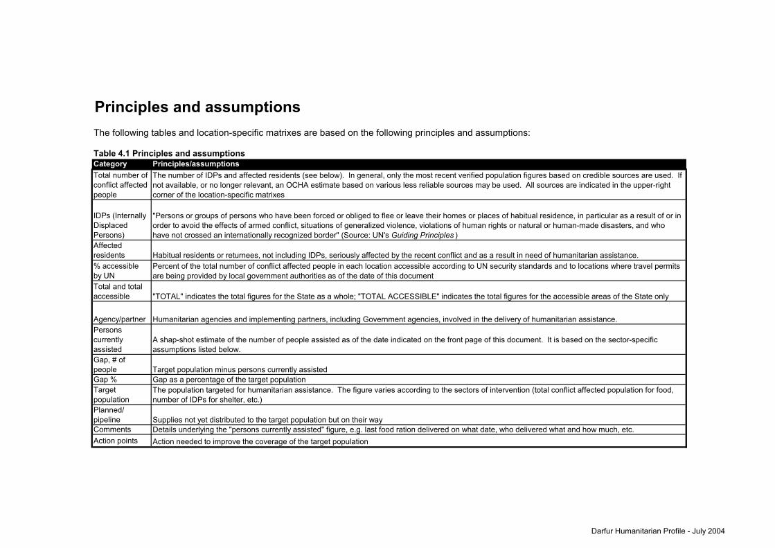
Principles and assumptionsThe following tables and location-specific matrixes are based on the following principles and assumptions:
Table 4.1 Principles and assumptionsCategoryTotal number of conflict affected people
IDPs (Internally Displaced Persons)Affected residents% accessible by UNTotal and total accessible
Agency/partnerPersons currently assistedGap, # of peopleGap %Target populationPlanned/ pipelineCommentsAction points
Principles/assumptionsThe number of IDPs and affected residents (see below). In general, only the most recent verified population figures based on credible sources are used. If not available, or no longer relevant, an OCHA estimate based on various less reliable sources may be used. All sources are indicated in the upper-right corner of the location-specific matrixes
"Persons or groups of persons who have been forced or obliged to flee or leave their homes or places of habitual residence, in particular as a result of or in order to avoid the effects of armed conflict, situations of generalized violence, violations of human rights or natural or human-made disasters, and who have not crossed an internationally recognized border" (Source: UN's Guiding Principles )
Habitual residents or returnees, not including IDPs, seriously affected by the recent conflict and as a result in need of humanitarian assistance.Percent of the total number of conflict affected people in each location accessible according to UN security standards and to locations where travel permits are being provided by local government authorities as of the date of this document
Humanitarian agencies and implementing partners, including Government agencies, involved in the delivery of humanitarian assistance.
The population targeted for humanitarian assistance. The figure varies according to the sectors of intervention (total conflict affected population for food, number of IDPs for shelter, etc.)
A shap-shot estimate of the number of people assisted as of the date indicated on the front page of this document. It is based on the sector-specific assumptions listed below.
"TOTAL" indicates the total figures for the State as a whole; "TOTAL ACCESSIBLE" indicates the total figures for the accessible areas of the State only
Action needed to improve the coverage of the target population
Target population minus persons currently assistedGap as a percentage of the target population
Supplies not yet distributed to the target population but on their wayDetails underlying the "persons currently assisted" figure, e.g. last food ration delivered on what date, who delivered what and how much, etc.
Darfur Humanitarian Profile - July 2004

Table 4.2 Sector-specific assumptions for "Persons Currently Assisted"
SectorsTarget population Assumptions
Food
Total conflict affected population
To feed 10,000 people for three months you need to provide about 526.5 MT assorted food (of which about 405 MT cereals). Assorted food package includes cereal, pulses, oil, CSB, and salt.
Shelter/NFIs IDPs
The number of people whose household (assumed to be 6 people) is provided with a minimum of one plastic sheet AND two blankets (e.g. if 1,000 plastic sheets and 1,000 blankets are provided, only 500 households = 3,000 people are considered "assisted").* Details on distribution, also of other NFI items, will be provided under "comments" in the location-specific matrix. Whether or not IDPs are living in camps will also be included here.
Clean water
Total conflict affected population
15 litres per person per day. One handpump serves 500 people. One 5,000L bladder serves 333 people and one 10,000L bladder serves 667. 1m3 = 1,000 litres. (Source: The Sphere Project)
Sanitation IDPs One pit latrine serves 20 people. (Source: The Sphere Project)
Nutrition
Malnourished children under five
The number of malnourished children under five receiving either therapeutic or supplementary feeding is estimated at 1/5 of 17% of the target population (the number is automatically calculated from the total number of affected people, unless it is in italics). (Source: UNICEF)
Primary health unit
Total conflict affected population
The number of people with access to primary health facilities based on the rule that there should be at least one medical assistant, one helper and one cleaner per 10,000 people (thus if only one medical assistant is available for 20,000 people, half the population will be considered assisted). (Source: WHO)
Basic drug supplies
Total conflict affected population
One UNICEF kit covers 5,000 people for two months, while one WHO kit covers 10,000 people for three months. If adequate medical personnel are available to distribute drugs to the entire population (and if drugs are distributed free of charge), then either all or none of the target population will be considered to be assisted based on when the drugs were delivered and when they will run out. (E.g., if there are 20,000 affected people, one kit will last only for two weeks - if more than two weeks have passed since distribution, then no persons will be considered as currently assisted).
Secondary health care
Total conflict affected population Target population is considered covered if free secondary health care is available within a 50 km radius.
EPIChildren under five
The number of children under five is estimated at 17% of the target population (the number is automatically calculated from the total number of affected people, unless it is in italics). Only if vaccines against measles and DPT3 (vaccine against the most common childhood diseases) have been provided is the target population considered to be covered. Information on disase surveillance training will be listed under "comments"
EPI (emergency measles campaign)
Children 9 months to 15 years
The number of children 9 months to 15 years is estimated at 41% of the total conflict affected population (the number is automatically calculated from the total number of affected people, unless it is in italics). (Source: UNICEF)
Agriculture
Conflict affected population with access to land
Coverage is defined as proportion of target population with access to land and provided with seeds and tools. 20 MTs=3300 HH (6 per HH); 1 MT= 165 HH. (Source: FAO)
EducationChildren 6 to 13 years
The number of children 6 to 13 years is estimated at 22% of the population (the number is automatically calculated from the total number of affected people, unless it is in italics). Coverage is defined as proportion of this population with access to free schooling.(Source: UNICEF)
Protection
Total conflict affected population
Narrative comments will be provided on current activities and plans since quantification is difficult. This column is therefore not included in the quantitative overview of needs and gaps.
Camp management IDPs
Narrative comments will be provided on current activities and plans since quantification is difficult. This column is therefore not included in the quantitative overview of needs and gaps.
*Note: Standard ICRC non-food item (NFI) kit covering one household includes tarpaulin plastic sheeting 6x4m for shelter, 2 blankets, 600g soap, 2 pairs of kangasfor clothing. Other kits are more comprehensive including cooking utensils, jerry cans, etc.
Darfur Humanitarian Profile - July 2004