Embed Size (px)
Citation preview

V I L L A G E D E S I G NS T A T E M E N T
2 0 0 4
O G B O U R N E S T A N D R E WM A I Z E Y& R O C K L E Y

1 Introduction 2
2 Historical Context of the Parish 4
3 Open Spaces and Selected Features 6
4 The Villages Today 8
4.1 Environmental and Landscape Setting 8
4.2 Geology 10
4.3 Flora and Fauna 10
4.4 Special Features 12
4.5 Employment & Equestrianism 16
5 Access 18
5.1 The Road system 18
5.2 Public Transport and Connections 20
5.3 Footpaths and Byways 20
6 Character Assessment of the Villages 22
6.1 Rockley 22
6.2 Ogbourne Maizey 26
6.3 Ogbourne St Andrew 28
7 A Living Community in the 21st Century 32
8 Design Guidance 34
9 Community facilities 38
10 Summary 38
APPENDICES:
1 & 2 The Community Aspirations and Agenda for Change 40
3 The Planning Policy Framework 42
4 The Community Consultation 43
5 Map of the Parish 44
6 Listed Buildings 45
7 Acknowledgements 46
8 Adoption 47
9 References 48
I N D E X
fig 1. - Contour map of the Parish,with the vertical scale enhanced.
Memory-Map 3D-ViewTM
Reproduced by permission ofthe Ordnance Survey on behalf of the Controller of Her Majesty's Stationery Office©
Crown Copyright 100042894
Cover Picture - Riders follow the Ridgewaytowards Barbury Castle, alongsideone of the many Gallops
fig 1. Contour map showing Parish of Ogbourne St Andrew

2
What is it?
This is a document produced by the community, free of vested interests,
which describes the unique nature of the parish and its aspirations.
Why do we need it?
As Supplementary Planning Guidance, the Village Design Statement (VDS)
is a material consideration that Kennet District Council and the Planning
Inspectorate shall take into account and give due weight to in determining
planning applications and appeals. Homeowners, developers and businesses
are encouraged to take the design guidance into account when considering
development to help maintain and enhance the attractiveness of the villages
to the benefit of all.
The planning policy framework provided by the Development Plan is
summarised in Appendix 3.The overarching policy stemming from the Area
of Outstanding Natural Beauty (AONB) designation is the conservation of
the natural beauty of the landscape.Where the Development Plan indicates
some development is acceptable in principle, the VDS provides
Supplementary Planning Guidance to encourage a detailed form that is
appropriate, sympathetic and of good quality.
As explained later, good quality can be discerned through a range of factors
such as precise siting, context, design, bulk and scale, materials, boundary
treatment and the effective use of hard and soft landscaping.
The VDS along with other Supplementary Planning Guidance, such as the
Kennet Landscape Conservation Strategy and the North Wessex Downs
Plan, therefore provides guidance complementary to, and more detailed
than, that found in the Development Plan.
What does it cover?
The Parish of Ogbourne St Andrew which lies within Kennet District,
comprises the villages of Ogbourne St Andrew, Ogbourne Maizey and
Rockley together with some isolated units such as Barbury Castle Farm.
The villages are small settlements within the Marlborough Downs that
form part of the North Wessex Downs Area of Outstanding Natural Beauty.
The villages are therefore set within a scenic and attractive environment.
They are predominantly residential but heavily influenced by agricultural
and equestrian development and activity.
What does it include?
Various sections provide information on history, the parish today (landscape
setting, character, etc.), design guidance and community aspirations.
I N T R O D U C T I O N T H E V I L L A G E D E S I G N S T A T E M E N T1
How was it produced?
The preparation of this VDS has included extensive consultation and
involvement of the local community.This is set out in more detail in
Appendix 4.A key part of the process was a village exhibition in August
2003 which was attended by 55% of all households.At this exhibition,
villagers expressed a number of views, preferences and aspirations that are
reflected in this document.
A final draft was then submitted to Kennet District Council for formal
approval and adpotion, following which, copies of this document were sent
to all householders, landowners and the Planning Authorities.
fig 2. Ogbourne St Andrew - 1866 (Charles Leaver - by kind permission of the Medici Society Limited)

4
From Barbury Castle in the North West the parish of Ogbourne St.Andrew
stretches for four miles to the crest of the valley side east of the A346.The
villages of Ogbourne St.Andrew, Ogbourne Maizey and Rockley lie in
valleys very near the southern edge of the parish.Away to the north and
west stretch the almost deserted Downs, one of the most sparsely populated
parts of Southern England (Refer to figure 1).
Four thousand years ago man transformed the primeval landscape, leaving
behind faint traces of New Stone Age and Bronze Age habitation.The Iron
Age is represented by the ramparts of Barbury Castle hill fort, through
which passes what has been dubbed "the oldest road in England", the
Ridgeway, forming the parish boundary along the northern limit.
In the sixth century AD, Saxon invaders founded (or took over) the present
villages naming them, "Oceburna" meaning "Occa's stream". From the
middle of the tenth century written records become more plentiful and
both St Andrew and Rockley are mentioned in Domesday.
Around each of the settlements the traditional three field system of
agriculture continued.Alongside these, however, large areas of land were
farmed as single units - the demesnes(1) of the three manors in the parish. In
1780 the small area still remaining in open-field cultivation was enclosed
and large farms emerged.Arable land occupied the more fertile valleys, but
vast tracts of the Downs were suitable only for sheep pastures.
Until the Nineteenth Century the three villages seem to have been more
equal in size, experiencing slow growth with very little dramatic change.The
core of St.Andrew remained along the road, to the east of the church, which
was part of the route from Marlborough to Ogboume St. George and beyond.
Southwards the same road went through Ogbourne Maizey and there were,
until early in the Nineteenth Century, buildings in the fields between them.
From 1762 the main route from Marlborough to Swindon was the road via
Rockley and Four Mile Clump which remained important until the
coming of the railway in 1881, which was closed in 1961.The present A346
was turnpiked(2) in 1819 and then began to replace the downland route. Its
existence also led to the building of houses by it and along the road linking
it to the ancient core of St.Andrew.
Towards the end of the Nineteenth Century a new element entered the
landscape - the stables and gallops which now occupy several hundred acres
In all three villages, the declining population has led to the demolition of
some of the older cottages and the closure of the school and church in
Rockley.The school in St Andrew has been in private hands for many years
and is currently closed for reorganisation. Of the cottages remaining, most
have either been extended or merged, so reducing the number of dwellings
H I S T O R I C A L C O N T E X T O F T H E P A R I S H 2
still further.There was some building in the 1920's and 30's, and six new
houses in Maizey in the 1980's, but there have been large additions in the
last ten years in both Maizey and St Andrew.
The new houses have begun to reverse the long decline in the population of
the parish (see census figures opposite), but the number of people living in each
is far fewer than it was in the past.The houses themselves are much larger than
the traditional cottages and their inhabitants, of necessity, either work elsewhere
in well paid employment or are retired.There are now comparatively few
people who have lived all their lives in the parish and very few who have
worked here all their days or, indeed, are employed in the parish.
Parish Census Data% age distribution
year popn. %male 0-44 45-59 60+1931 422 51 na na na1961 339 52 61 21 181971 275 44 59 21 201981 276 47 61 16 231991 256 50 57 24 192001 352 49 60 23 17
fig 4. Ogbourne St Andrew circa 1900
(1) demesne - a manor house with lands adjacentto it not let out to tenants.
(2) turnpike - a road on which there are, orwere, toll-gates; a main road.
fig 3. Harvesting at Rockley c1900

fig 12. Ogbourne St Andrew
A salient feature of the Parish as a whole is the backdrop provided by the
Downs.Their broad sweep gives a sense of space and broad vistas which, in
this document, we take as "open spaces", in lieu of the village green and
leisure areas which other, better endowed, villages possess.The downland
provides a picturesque and special setting, which requires careful and
thoughtful guardianship.
fig 9. Ogbourne Maizey fig 10. River Og fig 11. Green Lane
fig 8. Temple Bottomfig 5. View towards Rockley from Rough DownRockley Manor fig 6. Rockley Beech Drive fig 7. Two Acre Coppice
O P E N S P A C E S A N D S E L E C T E D F E A T U R E S3
6
Created using Memory-Map.
Reproduced by permission of the OrdnanceSurvey on behalf of theController of Her Majesty'sStationery Office© CrownCopyright 100042894

8
fig 14. Meadows between Bay Bridges and Maizey
4. 1 Environmental and Landscape Setting
The parish of Ogbourne St.Andrew lies two miles north of Marlborough.
Each of the three villages in the parish nestles in valleys below the surrounding
chalk downland.Approaching the Parish from the North or South along the
A346, one is presented with a broad riverine valley with fields bordered by
trees and bushes set against a backdrop of sweeping downland.
The villages of Ogbourne Maizey and St Andrew appear quite suddenly,
being hidden by folds in the ground (see fig 1).The approaches to Rockley
are even more attractive, the road from Marlborough to Broad Hinton
taking an elevated route above the deep valley leading to Bay Bridges, with
Rockley nestling behind a thick screen of trees.Approached from the
North, the wide sweeping vistas presented from the Downland heights are
probably amongst the best in Wiltshire.The distinctive nature of this area
has been recognised by Central Government and designated as an AONB.
Viewed from the top of the Downs, undulating downland, large arable fields
and gallops create an attractive and varied tapestry.The Parish (5,387 acres)
can be conveniently divided into two areas by the old coach road running
northwards from Rockley to Barbury Castle.The land to the east of this
line is almost exclusively arable with few mature trees; although in the last
two years several small areas of woodland have been planted.To the west,
around Rockley, there are mature woodland strips consisting mainly of
beech trees bordering the fields, in addition to several small woods.Around
the perimeters of some of the fields training gallops can be seen.
T H E V I L L A G E S T O D A Y4
fig 13. Winter evening on the Gallops

10
4.2 Geology
The greater part of the parish is downland formed on Upper and Middle
Chalk. Both layers are soft and permeable, so there is no surface water apart
from the two winterbournes mentioned below. Upper Chalk is the source
of the flints that occur profusely in the fields on the higher ground.At one
time there would have been numbers of sarsen stones, but most have been
cleared to allow cultivation and as a source of building material.At the
highest point, Barbury Castle (268m) in the north east, the chalk is capped
by clay with flints, forming a narrow strip extending in a south easterly
direction as far south as Four Mile clump.
Winterbournes are a notable feature of a chalk landscape, being rivers
which rise only in winter time.There are two such bournes in the parish,
the Hungerbourne, which rises below Barbury castle and only makes an
appearance after a very prolonged wet spell, often not being seen for several
years, and the Og (or Okebourne) which flows most winters.
The Og rises just north of Ogbourne St George and wends its way down the
valley on the east of the parish, through St Andrew and Ogbourne Maizey to
Bay Bridges and eventually joins the Kennet outside Marlborough.
The houses lying between the Og and the A346 lie within the designated
flood plain of the river, and although no flooding has occurred within
living memory, (the course of the Og at Ogbourne Maizey was straightened
some thirty years ago, since which time there has been no flooding of
houses), proper maintenance and cleaning of the riverbed are still essential
to avoid problems in the future.
Rockley lies in the valley of the Hungerbourne, which, like the Og, runs
through the alluvium(3) and flint gravels which line the valley down to Bay
Bridges, where the two bournes merge.The parish boundary follows this valley.
The name "Bay Bridges" has come down to us from medieval times when the
area was dammed to form a royal fish pond to supply Marlborough Castle.
Springs rise in all three villages but only in Rockley are they the sole supply
of water, with the spring water being pumped to the reservoir in North
Wood for treatment before it is piped back to the Manor and all the cottages.
From mid-winter onwards it is not unusual to see spring water bubbling
through the tarmac of the roads in St Andrew and from the foundations of
some of the older houses.
4.3 Flora and Fauna
The varied environment found in the Parish, allied with sparse human
habitation and less intensive agricultural methods, has resulted in a wide
range of flora and fauna.This rich diversity of plant and animal life is much
valued and provides an added interest to the many walkers and riders who
visit the Parish.The Railway Path, in particular, has a wide variety of
indigenous plants and animals along its verges, including increasing swathes
of cowslips in the Spring, with wild roses and blackberries later in the
Summer. In Autumn the Path presents a glorious riot of colour from the
wide mixture of leaves and berries along each side.
Elsewhere, cow and hedge parsley, hogweed, rough chervil, vetch, scabius,
buttercup, daisies, lords and ladies are amongst the many plants bringing a
colourful patchwork to the hedgerows and fields.
Copses and small woods are dotted around the Parish and provide not only
a range of trees (beech, oak, poplar, ash, etc.) but also a haven for wildlife,
with many larger animals such as deer, badgers, rabbits, hares, stoats, weasels,
the occasional pole cat and escaped ferret. Hare coursing was a favourite
sport at Rockley in earlier centuries and hares are still a common sight on
the downs. Of special note is the presence of glow worms (lampyris
noctiluca) which can be found on warm summer nights.
The bournes (the Og especially) encourage water birds, including herons
and, occasionally, kingfishers.The Willow trees are a particular feature along
the Og at St Andrew.
The open upland downs provide a good hunting ground for buzzards and
in recent years the red kite has been sighted.A few pairs of lapwings, once a
very common Wiltshire bird, still breed in the parish.There is also a
thriving colony of corn buntings with their distinctive jingling song. On
warm summer evenings Bats are a common sight. Owls also abound in the
Parish, mainly Tawnies, but with the ocasional Barn Owl and even Little
Owl, darting along the hedgerows with its seemingly erratic flight.
fig 17. Page from St Andrew's Women's Institute Commemorative book, 1965 Painted by Pam Lawton
fig 17. - Courtesy W.I. & Pam Lawton
(3) alluvium - matter transported in suspensionand deposited by rivers or floods
fig 16. Scabius
fig 15. Foxglove watercolour

fig 23. Rockley School
4.4 Some Special Features Within the Parish
These are a selection of features in the Parish, identified at the Village Exhibition,
which are considered to be of special note and which need protection.
St Andrew's Church
Dating from the 12th century with additions over the succeeding centuries
(including the bell tower in the 15th and the clerestory in the 16th), this
building serves as a magnificent centrepiece to St Andrew.There are a number
of interesting monuments inside the Church, with two fine examples dating
from the 17th century of the Goddard family (fig 19).The sarsen churchyard
walls and Victorian iron railings are noted in the Conservation Statement
(fig 18). Next to the Church is a bowl barrow dating from 1000BC, which
shows evidence of later Saxon and mediaeval burials.
The Railway Path
The Midland and South Western Railway, which was opened on 27th July
1881 and closed on 10th September 1961, ran parallel to the river and road
(A346).The closure of the railway has left the parish with a much cherished
amenity and landmark, the Marlborough to Chiseldon railway path (fig 20),
open to walkers, cyclists and horse riders. It is like a nature reserve with
many different species of wild flowers to be found along its length.
Ridgeway and Barbury Castle
The Iron Age hill fort lies on the Ridgeway and consists of an area of
twelve acres enclosed by an impressive and well-preserved set of defensive
banks and ditches.The Parish boundary runs through the ancient fort, the
other half of which lies in the Parish of Wroughton.
Schools
St Andrew's school was built in the late 19th century with a donation from
John Bannerman to the church. Closed by the Local Council following the
Plowden report, it operated as a private school from 1972. It is currently
closed for reorganisation (fig 22).
Rockley school was built at the same time as the chapel, by the Tanner
family. It is now used as an antiques restoration workshop (fig 23).
Ogbourne Maizey Manor
Allegedly used by King John as a hunting lodge, the current Jacobean
building is built from bands of stone and flint.The original ground floor
mullioned windows have been replaced with arched Georgian frames.The
dormers may be more recent (Pevsner). It is listed Grade II* (fig 24).
fig 20. The Railway Path fig 21. The Ridgeway & Barbury Castle
fig 19. Goddard familymonument
fig 22. St Andrew's School fig 24. Maizey Manor
12
fig 18. St Andrew's Church

fig 29. The Gallops Cemetary
Rockley Manor
This Grade II* listed building dates from the eighteenth century and was
built from stucco on stone and brick with a slate roof. In 1820, 1938 and
now 2003 / 2004 it has been reconstructed. Set in parkland, the house
presents a fine country house aspect, and is a valued and cherished
landmark (fig 25).
Rockley Village Pond
Rockley is the only village in the parish with a village pond, recently
relined and now re-establishing itself. Until the tractor took over as the
principal source of power, the pond was vital for drinking water for
livestock and to keep the cart wheels in working order, by swelling the
wood to keep the iron bands in place (fig 26).
Rockley Chapel of All Saints
Built in 1872 by the Tanner family, at the same time as Rockley School, it is
no longer used for worship and has been a cookery school, restaurant and
lately a nursery school, now closed.
The Parish War Memorial
Erected in 1922, it now records the sad loss and suffering experienced in
two World Wars.
The Gallops Cemetery
A unique landmark has been created on the downs, a small private
cemetery at the top of Green Lane. In it are buried members of the
Hartigan, Laye and Loudon families, one of whom (Mike Hartigan) gave his
life overseas while serving his country in World War II.The cemetery is well
cared for and surrounded by a mature beech hedge.
Other Special Features, which were identified at the Village Exhibition
and which are considered worthy of conserving are:
Four Mile Clump Maizey Manor Gates (fig 52)
The Gallops (cover & fig 31) Churchill Commemorative Tree
(on triangle by St Andrews Church)
The River Og (fig 36) Coronation Memorial at
St Andrews School
The "Lone Beech Tree" Godfrey's Barn (grid ref SU171729)
(grid ref SU178729) (fig 96)
Kissing Gate at Maizey Milestones at Rockley (fig 34)
fig 26. Rockley Pond fig 27. Rockley Cahapel of All Saints fig 28. The Parish War Memorial
14
Beneath the clean and spacious sky
Here let the sleeping horseman lie
Nor from his darlings sunder
And as the thoroughbreds flash by
This turf shall quicken suddenly
To hear the hoof beats thunder
fig 25. Rockley Manor

fig 35. Race horses exercising on gallops fig 36. Tractor with Coombe Down in distance
16
fig 37. Feeding horses near the "Lone Beech Tree"
4.5 Employment & Equestrianism
Although there are various farms in the Parish, modern farming methods
have reduced the number of agricultural employes to very small numbers.
Other sources of employment are provided by a small office development,
an educational venture and a restaurant in St Andrew; a riding tack shop,
saddler and antique restorer in Rockley; supplemented by several people
throughout the Parish running businesses from their homes. However the
major employer is the 'equine industry'.
The location of the Parish, set in 5,387 acres of downland, criss-crossed
with footpaths, bridleways and byways (possibly more miles of 'rights of
way' than any other county) is a fabulous setting for the horse owner. It is
not surprising therefore that the horse has played such a significant role in
the area over the last couple of hundred years.
Ogbourne Maizey sprang to racing prominence in the late 1890s when
theatrical impresario George Edwardes bought the 1000 acre estate and
Manor and installed his younger brother "The Major" as trainer. He was
succeeded by Paddy Hartigan, Sir Gordan Richards, Bill Marshall and Bob
Turnell amongst others. Famous winners were Pas Seul who won the
Cheltenham Gold Cup in 1960 and Salmon Spray, winner of The
Champion Hurdle in 1966.
Barbury Castle Estate (1200 acres) has an equally impressive history. Horse
racing and training have been a feature of this part of the downs since the
1800s and some of the gallops are over 100 years old.Ascot's most popular
horse, Brown Jack, was trained on the Barbury Castle gallops to win the
Champion Hurdle in March 1928 and became a legend by winning at
Royal Ascot every year from 1928 to 1934. In the early 1990s the
point-to-point course was recreated and the Mariborough Cup timber race
inaugurated. In 2005 Barbury Castle will host an international CIC***
horse trials.
Equine interest has grown significantly in the area over the last fifteen years
or so and its importance is best demonstrated by the following figures
(Note these are estimates as numbers constantly change).
Horses Employees
National Hunt 150 46Flat racing 70 17Point to Point 8 1Breeding 35 3Eventing 34 13Leisure 66 2
Totals 363 82
Comparison of these figures to thelatest census population figures forthe Parish (page 4) shows thathorses slightly outnumber people!
fig 31. Antique restoration in progress
fig 34. Bonita racing stablesfig 32. Running repairs on a bridle
fig 33. Supplying riders’needs

18
fig 38. Rockley's "Godcake" with milestone at thedangerous junction with very poor sightlines
5.1 The Road System
The Parish is situated close to Marlborough, with Swindon (the largest local
town) within easy reach.The A346, which runs through St Andrew and
Maizey, provides a fast route to Marlborough, Swindon and the M4
corridor, placing London and Bristol with their airports within a 70 mile
drive. From Marlborough, the A4 provides good access East or West to
towns such as Newbury, Reading, and Bath.
The A346 trunk road forms part of a main North-South route from Gloucester
and the M5, by fast modern dual carriageway (A 417), past Swindon to
Junction 15 of the M4.The route then narrows into a bottleneck for its whole
length through the villages, Marlborough and further south where it joins
major dual carriageways feeding Southampton, Portsmouth, Bournemouth and
Poole.The route carries a large number of heavy goods vehicles and about
15,000 vehicles in total pass through St Andrew each day. During the process of
consultation with villagers, the problems experienced with moving in and out
of the villages by vehicle, horse or on foot, were major concerns.
This road is always busy, but at rush hours and at holiday times it is very difficult
to get out of the village onto the main road or to cross on foot. Cycling on the
A346 is an option that only the most brave or foolhardy would contemplate.
With traffic often exceeding the 40 mph speed limit, and the road only just wide
enough for large trucks to pass each other, pedestrians are seriously at risk on the
narrow pavement between St Andrew and Maizey, particularly when walking in
the direction of the traffic. Parents with small children and pushchairs have to use
the path to reach their houses sited along the main road. Children use it to reach
the school bus and to visit friends; those taking the bus have to cross the road
either morning or evening (depending on which side of the road they live), a
hazardous undertaking.A particular problem is faced by wheelchair users - the
footpath is impossible to use, effectively trapping such people in their homes.
Noise is also a problem, especially at rush hour and holidays, when a continuous
roar precludes enjoyment of the gardens of properties bordering the road, and
indeed for some way into the villages of Maizey and St Andrew. Some noise relief
would be obtained by laying a low noise surface through the length of the village.
Predictions of the likely increase in traffic density present a sombre picture
with respect to the problems stated above.Access and pedestrian safety will
deteriorate and noise levels increase. Urgent action is required in the near
future to alleviate the existing problems and negate the effect of the inevitable
increase in traffic.The recommendations of the A338/A346 Working Group
could lead to some alleviation of the problems, if fully implemented.
Rockley lies just off the Marlborough to Broad Hinton road.The village
road exits on a curve masked by a hedge and a poor sight line. Concern is
expressed by villagers that the junction is very dangerous and that traffic
calming is required to slow the speeding vehicles.
The road from Maizey to Rockley is a steep single track with passing places
formed over the years by vehicles climbing the banks and is frequented by
strings of racehorses and heavy farm vehicles. However, any improvement in
width would almost certainly result in it being used as a short cut by many
more vehicles, and it is felt that the best solution would be some form of
restriction signs at both ends of the road.fig 39. Lorry at Ogbourne Maizey
on the A346 showing thenarrow and dangerous footpath
A C C E S S5

20
fig 40. The River Og at St Andrew
5.2 Public Transport and Connections
There is an hourly bus service along the A346 to both Marlborough and
Swindon, from where wide ranging coach services are available. Rockley
has a limited shoppers' bus service, used at present by only one Rockley
couple, and they now need to telephone to call for the bus. Obviously this
route is in danger of closure from lack of use. Good rail connections exist
from Swindon, Pewsey and Great Bedwyn.
A charity volunteer local taxi service (Link) exists for elderly or
handicapped people, which can be called upon if necessary.There is no
charge for the service but users are asked to make a donation towards
expenses.This service is greatly valued by those who use it.
5.3 Footpaths and by-ways
There is a wealth of well-used footpaths and bridleways across the parish,
the Marlborough Downs offering a wonderful open landscape for walking
and riding, away from roads (see appendix 5).
Of particular note are:
■ A footpath from Maizey to St Andrew following a right of way with
stiles and a kissing gate across the fields.
■ A cycle and foot path following the track of the old Swindon-
Marlborough railway from Chiseldon to Marlborough.The path is used
by many villagers and visitors to the area; it has a wide variety of
wildflowers and is a great asset to the area.
However, to the many riders in the area the A346 presents a hazard to
crossing, as it does to pedestrians, and there is no bridleway from Maizey to
St.Andrew to reach a safer crossing point.
The parish is also crossed by some byways, with a part of The Ridgeway
forming the northern limit to the Parish boundary.There is some misuse of,
and damage to, the byways by a few inconsiderate vehicle users.There is
support in the Parish for the proposed closure of these byways to leisure
vehicle traffic in wintertime.The Conservation Statement suggests that the
use of leisure vehicles on the byway from Wetpits to St George is undesirable.
fig 41. Ice at Old Eagle due to the Hungerbourne overflowing fig 42. Copse at Man's Head on Broad Hinton Road

fig 46. Decorative hung tiles
Slate roof
fig 47. Hipped roof(7)
Flemish bond brickwork with glazed headers
Arched and straight lintel window openings
The History and Landscape Setting sections (pp 4 & 8) described how the
three settlements became established in the Parish many years ago.The
buildings set around the manors and built substantially from local materials
cleared from the fields, were designed to house the estates' workers. Some
of the special features illustrated (pp 12 & 14) give an evocative glimpse of
the Parish's past and present character.These small, old settlements set
against the expansive Downland sweep (as outlined on pp 6 & 7), define
the very essence of the Parish.
The next three sections look more closely at the detail within each of
the villages.
6.1 Rockley (20 houses)
This village is currently undergoing considerable refurbishment, as most of
the buildings are owned by the Manor, which is itself under extensive but
sympathetic re-development.The housing stock has remained unchanged
for many years and is mostly clustered around the manor. Beyond Rockley
lies Temple Estate, an arable farm with some livestock and equestrian
interests. Only part of this estate lies within the Parish.
The predominant features of the houses (which is reflected in all three
villages) is the use of local materials for their construction. Sarsen stone and
flint are extensively used, often banded by mellow red brick.Where brick
walls exist, Flemish Bond(4) is often used with glazed or darker headers(5) (see
photos). Some excellent geometric patterned brickwork exists (fig 87) and
there is also some decorative tile hung construction in place (fig 46).
Timber framing is evident in some of the older properties.
(4) Flemish Bond - alternate headers(5) & stretchers(6) in each course of bricks(5) Header - short side of brick showing on wall surface(6) Stretcher - long side of brick showing on wall surface(7) Hipped roof - sloping roof at the end as well as the sides
fig 43. Windows are small paned, withglazing bars painted white, typicallywith arched brick lintels over, althoughsome straight lintels are also seen.
fig 44. Sarsen, flint and brick walls
Low Sarsen boundary walls
Semi-hipped roof (7)
fig 45. Only three thatched properties existtoday although there were certainlymore in earlier times. These are allhipped roof constructions.
C H A R A C T E R A S S E S S M E N T O F T H E V I L L A G E S6
22
24
fig 53. fig 54.
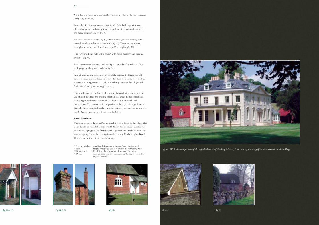
Most doors are painted white and have simple porches or hoods of various
designs (fig 48 & 49).
Square brick chimneys have survived in all of the buildings with some
element of design in their construction and are often a central feature of
the house structure (fig 50 & 51).
Roofs are mostly slate tiles (fig 52), often hipped (or semi hipped) with
vertical ventilation features in end walls (fig 53).There are also several
examples of dormer windows(8) (see page 27 examples) (fig 52).
The roofs overhang walls at the eaves(9) with barge boards(10) and exposed
purlins(11) (fig 53).
Local sarsen stone has been used widely to create low boundary walls to
each property, along with hedging (fig 54).
Also of note are the uses put to some of the existing buildings; the old
school as an antiques restoration centre; the church (recently re-roofed) as
a nursery; a riding centre and saddler (mid way between the village and
Maizey) and an equestrian supplies store.
The whole area can be described as a peaceful rural setting in which the
use of local materials and existing buildings has created a residential area
intermingled with small businesses in a harmonious and secluded
environment.The houses are in proportion to their plot sizes, gardens are
generally large compared to their modern counterparts and the mature trees
and hedgerows provide a soft and rural backdrop.
Street Furniture
There are no street lights in Rockley, and it is considered by the village that
none should be provided as they would destroy the essentially rural nature
of the area. Signage is also fairly limited at present and should be kept that
way, excepting that traffic calming is needed on the Marlborough - Broad
Hinton road at the entrance to the village.
(8) Dormer window - a small gabled window projecting from a sloping roof.(9) Eaves - the projecting edge of a roof beyond the supporting walls.(10) Barge boards - board along the edge of a gable to cover the rafters.(11) Purlins - the supporting timbers running along the length of a roof to
support the rafters
fig 48 & 49. fig 50 & 51. fig 52.
fig 55. With the completion of the refurbishment of Rockley Manor, it is once again a significant landmark in the village

fig 60.
6.2 Ogbourne Maizey (46 houses)
Ogbourne Maizey provides an interesting comparison with Rockley.TheManor, as with Rockley, owned most of the houses in the village in the1950's, but subsequently sold off parts of the estate.This resulted inconsiderable new building activity.Three quarters of the existing houses havebeen built (or converted) since 1950, with the greatest change occurringfrom the late 1980's. In this period there has been minimal development ofthe infrastructure.The village, despite its proximity to the A346, still retainsan air of ancient charm in a peaceful and essentially secluded setting.
The original buildings are again built of local materials: sarsen, flint andmellow red brick, often panelled. Roofs were thatch (four remaining), slateor red clay tiles. Hipped (or semi hipped) roofs were evident but are nowmostly gabled(12) after re-roofing over the years. Roofs again overhang walls atthe eaves with barge boards and some with exposed purlins.Windows aresmall paned with white glazing bars. Boundaries of the older properties tendto be a mixture of hedging and trees surrounding large gardens (fig 57).
The newer houses are a mixture of designs, usually detached, built usingmodern materials which mostly blend in with their surroundings and havetried to reflect local architectural detail (fig 58 & 59).
The latest developments around the Manor have used local sarsen stone forboundary walls and in some of the house walls with flint, but mostly the houses arehalf clad in black timber with dark slate gabled roofs with many dormer windowsand roof lights(13) Walls are Stretcher Bond(14) in red brick (fig 60 & 61).
Overall, this results in starker buildings accentuated by white windows.Withsmaller plots within high sarsen walling, this results in an enclosedsettlement at odds with its more open neighbours and not lightened, as yet,by any significant landscaping although this will mellow with time.
The Manor is a fine flint and sarsen stone building with some mullionedwindows(15) and has seen many changes to its façade over the years butremains a very attractive Grade II* listed building (fig 62).
Maizey also contains Bonita Racing Stables with a fine Edwardian (c 1903)house and racing yards providing local employment.
Street furniture
There are only three streetlamps throughout the settlement, and yet severalwithin the Manor Stables development.As with Rockley, there is aconsensus that extra lighting would be detrimental to the character of thearea. Signage is more detailed than in Rockley, and is clearly necessaryalong, and leading to, the A346.
fig 56. fig 59. House built c1950,extension on right
fig 57. fig 58. Mid - 1980's house
26
fig 61. fig 62. Ogbourne Maizey Manor
(12) Gable - the triangular part of side wallssupporting the roof
(13) Roof lights - windows inset into the slope of the roof(14) Stretcher Bond - courses of bricks with just the long
section of brick exposed.(15) Mullioned windows - the upright divisions of stone or iron
between panes or casements
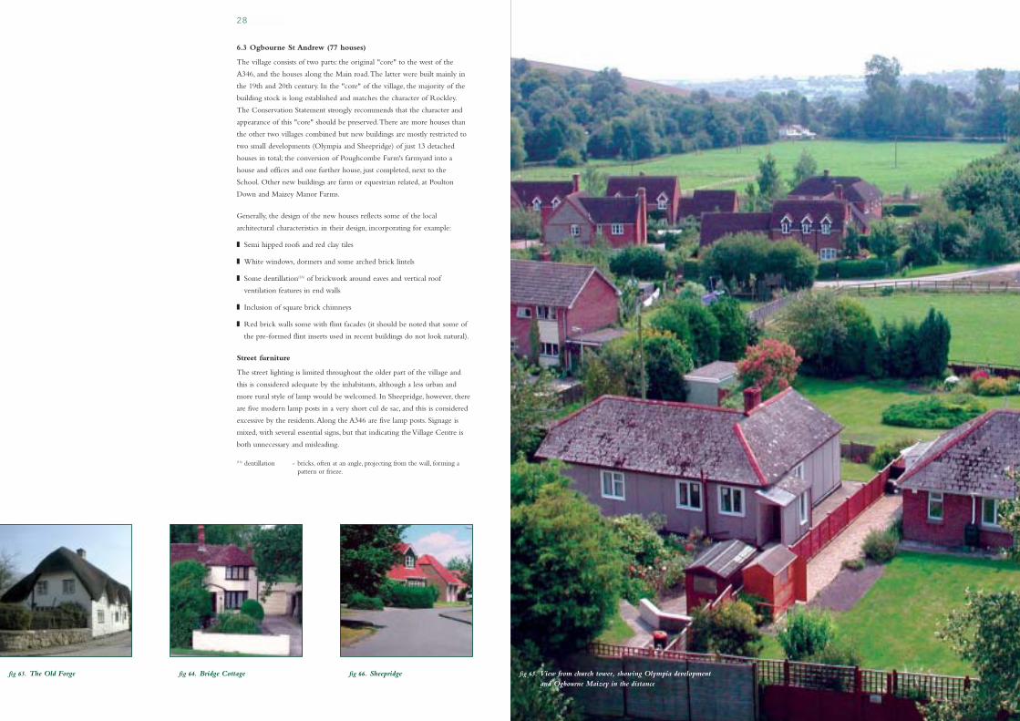
fig 65. View from church tower, showing Olympia developmentand Ogbourne Maizey in the distance
6.3 Ogbourne St Andrew (77 houses)
The village consists of two parts: the original "core" to the west of the
A346, and the houses along the Main road.The latter were built mainly in
the 19th and 20th century. In the "core" of the village, the majority of the
building stock is long established and matches the character of Rockley.
The Conservation Statement strongly recommends that the character and
appearance of this "core" should be preserved.There are more houses than
the other two villages combined but new buildings are mostly restricted to
two small developments (Olympia and Sheepridge) of just 13 detached
houses in total; the conversion of Poughcombe Farm's farmyard into a
house and offices and one further house, just completed, next to the
School. Other new buildings are farm or equestrian related, at Poulton
Down and Maizey Manor Farms.
Generally, the design of the new houses reflects some of the local
architectural characteristics in their design, incorporating for example:
■ Semi hipped roofs and red clay tiles
■ White windows, dormers and some arched brick lintels
■ Some dentillation(16) of brickwork around eaves and vertical roof
ventilation features in end walls
■ Inclusion of square brick chimneys
■ Red brick walls some with flint facades (it should be noted that some of
the pre-formed flint inserts used in recent buildings do not look natural).
Street furniture
The street lighting is limited throughout the older part of the village and
this is considered adequate by the inhabitants, although a less urban and
more rural style of lamp would be welcomed. In Sheepridge, however, there
are five modern lamp posts in a very short cul de sac, and this is considered
excessive by the residents.Along the A346 are five lamp posts. Signage is
mixed, with several essential signs, but that indicating the Village Centre is
both unnecessary and misleading.
(16) dentillation - bricks, often at an angle, projecting from the wall, forming apattern or frieze.
fig 63. The Old Forge fig 64. Bridge Cottage fig 66. Sheepridge
28

fig 71. The Old Manor fig 67. The Old Cottage
Five thatched properties remain, including a fine example of a raised grain
store on staddle stones at The Old Manor (fig 69).Another significant
building is "The Old Cottage", elements of which are mediaeval, and are
said to be amongst the oldest building structures in Wiltshire (fig 67).
A variety of other buildings add to the character of the village:
Ogbourne St Andrew has a local pub,The Wheatsheaf, which is now a
popular restaurant. St Andrew's beautiful Church has twelfth century
origins.There is a private education establishment using the old village
school premises.Two equestrian establishments for eventing are to be found
at Maizey Manor Farm, and there are two farms at Poulton Down and
New Barn which are mainly arable, but with some livestock.These all
provide some local employment. Finally, on the North Western edge of the
Parish at Barbury Castle is the Barbury Castle Estate comprising farm,
racing stables, and a point-to-point course again providing some local
employment to the Parish.
The open gardens of Poughcombe Farmhouse (fig 70) and The Old Manor
(fig 71), together with the churchyard and paddock, form part of the open
area at the "core" of the village, as defined in the Conservation Statement.
The unique nature of this setting requires conservation.
The village of St Andrew has retained its rural nature and its core, protected
by the designated Conservation Area, remains mostly undeveloped. It
contains a high proportion of listed buildings and enjoys a peaceful setting
undisturbed by any through traffic. Surrounded by open fields and
meadows, it benefits from many beautiful views with a superb backdrop of
rising downlands.
fig 68. Little Thatch and Snail Cottage
fig 69. Granary at the Old Manor fig 70. Poughcombe Farmhouse
30

32
Before considering the Design Guidance that this VDS sets out for the future,
it is worth reflecting on how well equipped the Parish is to support itself and
to encourage its inhabitants.The sparsely populated area, with its three small
settlements at the southern boundary lacks the basic amenities of shops, state
schools, meeting places and leisure facilities, and consequently faces considerable
challenges for the 21st century.There is clearly a spirit of community, but this is
in spite of the obvious constraints detailed elsewhere in this document.A major
challenge is to nurture and expand this spirit and the VDS project has offered
the means to begin the process and demonstrate that self-help is a way forward.
There is a need to encourage the obvious pride and interest in the Parish
which has been exhibited during this VDS exercise and to nurture the
feelings of shared purpose and common aspirations.As with any community,
collective and personal responsibilities are to be encouraged, in a spirit of
inclusivity and openness.To aid these ambitions, there is a need for effective
communication, which can be achieved in a variety of ways: village events,
clubs, societies, newsletters, web page, etc. However, the lack of a Parish
meeting place, with no shop, no school, no village centre, no sports area poses
a challenge in bringing people together.At present there are active: the
Church, a Parish Council, the Women's Institute and the VDS committee.
As a result of the VDS Village Exhibition, however, a parish History Group
has been formed; a theatre group and an arts group are being discussed and
regular concerts have started in the Church. Other ideas are also actively
being considered.
There are two possible routes forward to provide a meeting place: (1)
modification of the Church interior to create a usable space for meetings
and concerts, or: (2) fund raising to provide a village hall (provided a
suitable plot of land can be found and running costs can be afforded).
Provision of a shop and school does not seem a viable option, given the
small population and demographics of the villages, but this inevitably
increases the pressure to own and use a car, with the consequential impact
on parking and congestion.
Acquisition of a village green with a sports or play area might be possible if
a suitable site(s) and funding can be found.This is an important project,
given that 22% of the population are aged 14 or under; and a further 11%
are aged 15 - 24 (Census 2001).
Economic pressures also serve to define the villages, with little work being
currently available and even that is under threat from a continuing loss of
local agricultural jobs and their attendant tied cottages.The growth of
leisure activities to some little extent counterbalances this trend, but lack of
affordable housing and the relatively high cost of country living presents a
barrier for younger families and the lower paid.Also there are few Housing
Association properties within the Parish.fig 72. Fund raising concert in St Andrew's church
A L I V I N G C O M M U N I T Y I N T H E 2 1 S T C E N T U R Y7
The net result is a population growing in affluence, some of whom work from
home.The provision of better internet access and more flexible working
practices will accelerate this trend.This is generally beneficial as such workers
do not have to commute by car, especially during peak hours.Their presence
during the day can also contribute to the liveliness of the community and the
use of local facilities. Such workers are also more likely to have time to
participate in community events and to achieve a good balance between family
and working life, which is also good for the overall well being of the area.
This VDS project has produced much thought and debate amongst the villagers
about how they would like to see their communities develop.The aspirations
which emerged from these discussions are detailed in appendices 1 & 2.
fig 73. St Andrew's church from byway to St George

fig 79. fig 74.
At the Village Exhibition, the community was asked to express their likes and
dislikes on a range of issues, and encouraged to comment on all aspects of life in
the Parish. In this section of the Design Statement, just those comments relating to
housing design are described.As with all good design, any change needs to take into
account the wider issues and context to be successful.Therefore, any development
within the Parish needs to encompass these guidelines in the context of the overall
Village Design Statement in order to preserve the unique character of the Parish.
These are the preferred designs of the Parish community but do not
mean that future designs must include every feature. Indeed one of the
fundamental conclusions from the consultation process was that any new
build or alteration needs to be in proportion and be appropriate to its
function with its various design elements in harmony with one another and
their surroundings. Since there is a mixture of village and rural environments,
the constraints detailed in the Kennet Local Plan (replacement) -
Supplementary Guidance should be upheld, i.e.:
■ Firm emphasis on the protection of the countryside for its own sake.
■ Management or enhancement should aim to reinforce or restore the
local landscape vernacular
■ Particular priority should be given to the mitigation of intrusive features
or influences which detract from the rural character of the landscape
(e.g. hard edges, unsightly buildings, etc.)
Given these guidelines and the opinions expressed by the three villages, the
following preferences can be detailed:
Walls of sarsen stone, flint and mellow red brick (matching existing
colours) either banded or in some combination is preferred (fig 74). Plain
red brick softened with dark header patterning and decorative tile hung
finishing is also welcome (fig 75 & 76). Unrelieved plain red brick finishes
should be avoided. Lime mortar and not cement should be used wherever
appropriate, especially when repairing or renovating old walls.
Where sarsen is used, it should be from re-cycled sources only.
Dentillated brickwork below eaves and vertical ventilation detail in end walls
adds interest (fig 77 & 78), as do exposed purlins with barge boards (fig 79).
fig 75 & 76. fig 77. fig 78.
D E S I G N G U I D A N C E8
34

fig 85. Chimney with corbelledbrickwork
Roofs should be thatch (using long straw in preference to reed), slate or
red clay tiles, hipped (or semi-hipped) with overhung eaves and, preferably,
exposed purlins (where building regulations allow). Concrete tile and flat
roofs are to be discouraged. Dormer windows, where appropriate, should
conform to the style shown in figure 80.
Roof lines and building heights should complement existing structures and
be in harmony with their surroundings.
Windows should be small paned with glazing bars, light coloured
preferably with arched brick lintels over, although flat finishes are
acceptable.Wherever possible, wooden frames are preferred (fig 81 & 82).
Doors with porches or hoods are preferred (fig 83 & 84).
Chimneys add interest and balance to a house design and should be square with
corbelled(17) courses and decorative pots rather than plain cylinders (fig 85 & 86).
Rainwater Fittings should be unobtrusive, both in design and colour
(preferably black).
Boundaries need to reflect their rural surroundings with appropriate
hedging, post and rail fencing or low walls in sarsen stone, flint, red brick or
a suitable combination.
Services need to be underground with unobtrusive meter boxes.
Restoration, Conversion and Extensions
Sympathetic restoration, conversions or extensions to existing properties
will take account of the current:
■ Roofing materials, size shape and pitch
■ Wall material and pointing - use of lime mortar.
■ Style, shape and size of existing windows and doors
Repair or renovation rather than replacement should be a guiding principle.
Changes must be in sympathy with the existing structure and its surroundings,
retaining, where possible, traditional styles and materials. Flat roofs should
be avoided.
Extensions shall be in proportion and balanced with the original building.
A good example of a sympathetic extension is shown (fig 87):
(17) Corbelled - successive brick courses projecting above the previous one, giving acantilevered effect.
Design Guidance - General comments
New developments need to have regard to the rural context to ensure that its
form and size is not detrimental to the landscape. Formal landscaping of the
site needs to ensure that it blends into its surroundings with suitable (native)
trees and shrubs, given the chalky soils in the area.The long term
maintenance and replacement requirement of trees, shrubs and hedges should
be born in mind.The use of evergreen hedges or trees, or modern fencing, in
prominent positions should be avoided. Care must also be taken to avoid
interfering with the many open spaces and vistas surrounding the settlements
Accommodation in new housing or in extensions should, where possible, or
appropriate, include space to facilitate home working, subject to the proviso
that the size and characteristics should be in keeping with village housing style.
The rural environment of the Parish with its narrow lanes and the regular
passage of wide agricultural vehicles needs to be considered in future
changes. Lanes are already clogged with parked cars and public parking
spaces need to be provided in the future as well as sufficient space, off road,
in any new development. Given the relatively isolated nature of the villages
and difficulties with regular public transport, the necessity of adequate off
road parking cannot be overstated.
Street lighting should reflect the findings of the Village Survey and, if
installed, be discreet and in keeping with a rural setting and be non light
polluting.The density should be in keeping with the character of the village
and in any new "suburban" style development be restricted or avoided.
fig 82. Arched brick lintel, small panes
fig 83. Typical hood fig 84. Typical porch fig 86. Chimney with decorative pot fig 87. Sympathetic house extension
36
fig 80. Dormer window -preferred style
fig 81. Small panedwindows & dormers

38
Where development is of a scale or kind that could appropriately be the
subject of a planning agreement under Section 106 of the Town and
Country Planning Act 1990, as amended, either volunteered or as a
requirement of planning policy, the provision or contribution towards
community facilities will be encouraged. By way of example, this could be
the provision of land for a community hall, open space or play areas, or
parking and/or funds for their development.The provision or contribution
towards such facilities will generally be a material consideration in favour of
a development scheme in principle. However, the willingness of a developer
to include such an offer should not be regarded on its own as an
inducement to allow development that would otherwise be wholly
unacceptable, when assessed against the Development Plan and this VDS.
C O M M U N I T Y F A C I L I T I E S9
It can be seen in the previous sections of this Design Statement how the
past involvement of the Parish in farming and equestrianism, sited in excess
of 5,000 acres of downland within a designated Area of Outstanding
Natural Beauty, has created a special and unique environment.This is
reflected in the distinctive character of the villages and their special features,
which have been highlighted in this document.
The changes that would be needed to support and encourage the Parish in
the 21st century, and how they might be achieved, have been set out.
There are clear guidelines to aid future property changes, large or small.
Detailed in the annexes are the planning policies which govern the
development of the Parish and the course of the consultation process used
for the preparation of this Village Design Statement, which will, in due
course, be accepted as supplementary planning guidance.
Finally and most importantly, annexes 1 and 2 list the aspirations of the
Parish and the specific changes that should be pursued.
S U M M A R Y10
fig 88. Churchill commemorative tree 1965
40
AGENDA FOR CHANGE
■ Provision of a Village Hall / meeting venue
to be investigated (L)
■ Acquisition of a play area/leisure facilities (L)
■ Increased social interaction (societies, etc) (S)
■ Improve foot paths / access (M)
■ Parish Newsletter (S)
■ Web Page (S)
■ Broad Band access (S)
■ Improved TV/radio & mobile reception (M)
■ Controlled, thoughtful development in line
with the unique nature of the Parish. (S)
■ The guidelines detailed in this VDS to
be applied (S)
■ The possibility of encouraging such an initiative
should be investigated. (M)
■ Support expansion of existing businesses (S)
■ Support new employers into the Parish (S)
■ Encourage people to work from home,
with the provision of offices within
extensions / new builds. (S)
THE COMMUNITY ASPIRATIONS
Integrated Community:
The Parish aspires to become a more integrated
community with its own identity, reflecting the rural
context, independent of, but related to, its neighbouring
townships, notably Marlborough.
Communication:
A modern community requires communication both
face to face and through other media. Easier access
between Andrew and Maizey/Rockley is desirable.This
could be achieved by enhancing the existing footpaths
and cycle track connections between the villages to
provide an all-weather, accessible, safe, and (possibly)
discreetly lit pedestrian route.
Development:
Many inhabitants have deliberately opted for a village
life.This implies a sense of community, rural character
and peace.Any development of the villages should
recognise these overriding characteristics.
Affordable Housing:
We aspire to keep our families close to us.At present all
of the housing in the village is too expensive for first
time buyers so there is no hope of generations living
together in the same village.When new developments
are planned some inexpensive housing, at an appropriate
density and style to match local characteristics should
be included.
Employment:
We would like to encourage small businesses within the
community, either by expansion of existing enterprises
or by the creation of new ones. Suitable conversion of
existing buildings for such purposes should be
encouraged.Any expansion should take into account
the Design Guidance principles and the example of
successful integration of business in the rural
environment as exemplified in Rockley.
(L)= > 10 years (M)= 5 - 10 years (S)= < 5 years
AGENDA FOR CHANGE
■ Provision of a by-pass (L)
■ Low noise road surface to be laid (S)
■ Stricter imposition of existing speed limit (S)
■ Reduce limit to 30mph (S)
■ Improve wheelchair access (S)
■ Improved safety for pedestrians on footpath (L)
■ Pedestrian Crossing on A346 (S)
(alternative solutions - bridge / subway to be considered)
■ Effective traffic calming required (S)
■ Improved drainage required (S)
■ Improved signage required (S)
■ The practicality of finding a suitable site
and funding should be pursued. (L)
■ Acquisition of a play area / leisure facilities (L)
■ Require adequate parking provision in all
developments, new buildings or extensions. (S)
■ Adherence to Kennet Local Plan guidance (S)
■ Ensure River Og is properly maintained (S)
■ Create Nature Reserve along old rlwy track (M)
■ Re-instate water meadow by A346 (L)
■ Stop 4x4 & motor cycles using By-Ways & Bridleways (S)
■ Remove unnecessary & unsightly signs (S)
■ Replace dilapidated bus shelters (S)
THE COMMUNITY ASPIRATIONS
Safety - The Roads
The greatest obstacle to the villages achieving a degree of
integration, peace and identity, is the A346.The density
and speed of the traffic prevents villagers from walking
along this route. It prevents any social interaction along
the route and is a hazard to safety.The aspiration of the
villages is to have a by-pass which would remove the
hazard, pollution and social blight which result from the
main road.Traffic calming is essential.
The Rockley turning on the Marlborough to Broad
Hinton road is dangerous, with poor sight lines.At Old
Eagle the road is prone to flooding and icing.
The road from Rockley to Maizey is too narrow for
large or heavy vehicles.
Village Green:
There is no formal recreational area for the children of
the villages.The villages aspire to having safe and
attractive public recreational areas in the village complex.
Leisure activities:
These should be supported and encouraged by our villages.
Equestrian activity is an important leisure and business
activity in the villages and this should be recognised and
supported. But there are many young children for whom
there is nothing.A vibrant mix of activities could be
supported by good outdoor and indoor facilities.
Off-road parking
This is unsightly and hazardous to pedestrians. It is
desirable that adequate off-road parking is provided
where possible for existing residents and new houses
should have sufficient parking space for the vehicles of
occupants, teenage children and visitors.
Environment:
Any development or change of use which threatens any
aspect of the environment should be actively discouraged,
whilst encouragement should be given to those proposals
which augment, safeguard wildlife and the natural habitat,
or improve the visual impact of the Parish.
T H E C O M M U N I T Y A S P I R A T I O N S A G E N D A F O R C H A N G EAPPENDIX 1 APPENDIX 2
42
■ The core of Ogbourne St Andrew is a designated
Conservation Area, in which Local Plan Policies HH5
and HH6 specifically apply.These policies seek to
ensure that any new development helps to preserve or
enhance the special character and appearance of the
conservation area and to control the demolition of
unlisted buildings. Kennet District Council has
produced a Conservation Area Statement that
provides a detailed description which highlights both
the strengths and opportunities for improvement.The
Conservation Statement should be read in
conjunction with this VDS for proposals may directly,
or indirectly, affect the conservation area.
■ Opportunities for new development are even more
limited in Rockley and Ogbourne Maizey where
Local Plan Policies HC26 and HC27 apply.Apart
from sympathetic alterations or extensions to existing
buildings, new development is confined under these
policies to the requirements of agriculture, forestry or
employment essential to the countryside, holiday
accommodation converted from existing buildings
and the conversion of listed buildings where that is
the only economic means of retention.
■ The statutory planning framework that applies to all
three villages is therefore restrictive in its nature and
significance. New development other than infilling,
replacement or extension is, therefore, unlikely to take
place in the foreseeable future.
Insofar as limited development is acceptable in principle
under this framework, the Village Design Statement shall
form Supplementary Planning Guidance to provide
design guidance to encourage appropriate, sympathetic
and good quality design.
■ For the purposes of Section 54a of the Town and
Country Planning Act 1990, as amended, the
Development Plan comprises the adopted Wiltshire
Structure Plan and the Kennet District Local Plan, as
adopted 2004.
■ The Structure Plan deals with strategic issues, including
the overall provision for housing.The Local Plan
translates the strategic framework to district level and
sets out the planning framework for the towns and
villages to regulate the use and development of land.
■ The three villages of Rockley, Ogbourne Maizey and
Ogbourne St.Andrew are all within the Marlborough
Downs and included in the North Wessex Downs
Area of Outstanding Natural Beauty (AONB).This
statutory landscape designation is of national
importance being second only to a National Park.
■ The overarching policy framework that applies to all the
villages is the conservation of the natural beauty of the
landscape and this is reflected in Local Plan Policy NR7.
Supplementary Planning Guidance in the form of the
Kennet Landscape Conservation Strategy has been
prepared to provide more detailed guidance on enhancing
the landscape and the management of the countryside.
■ Ogbourne St Andrew is included in Local Plan Table
H5 and so Policy HC24 applies.This indicates all
future housing development should be restricted to
infilling, the replacement of existing dwellings or the
re-use or redevelopment of existing buildings, within
the existing built up area.The existing built up area is
not defined. Infilling would not normally include land
on the edge of the village, even when between isolated
development just beyond the main built up area.
fifteen times, producing six Newsletters (delivered to
every home) detailing both VDS progress and results
amongst many other items of interest.A Village
Exhibition was held in August 2003 to gather
Parishioners views and feedback to ideas (126 villagers
attended, from 55% of households).
Our approach to this exercise has been driven constantly
by a desire to consult widely and communicate regularly
with the whole Parish and interested parties.
A committee of 11 Parishioners representing the three
villages in proportion to the number of households in
each village was convened in January 2003 and has met
organisations received all of our Newsletters and we
would like to take this opportunity to thank them for
their time, help and advice throughout the project.
We have worked closely with Kennet District Council
and Community First to ensure we maximised our
results via a valid, thorough, consultation processes. Both
THE PLANNING POLICY FRAMEWORK THE COMMUNITY CONSULTATIONAPPENDIX 3 APPENDIX 4
DATE ACTIVITY RESULT
13-Jun-02 Survey of Parishioners 91% Yes vote12-Nov-02 Invitation to Public Meeting 27 people attend meeting02-Dec-02 Public Meeting 78% Yes Vote29-Jan-03 Meeting with KDC Processes & procedures agreed29-May-03 Meeting with Community First Planning detail for Village Exhibition04-Jun-03 Meeting with KDC Parish Maps & Reference Material identified9/10-Aug-03 Exhibition & Fund Raising Events 55% of households attend Exhibition11-Sep-03 Meeting with KDC Exhibition & results discussed & next steps discussedOctober 04 First Village concert money raised for VDSFeb-04 First draft submitted to Kennet General approval - minor detail to be changedMarch 04 Second Village concert money raised for VDS22-April-04 Presentation of Draft VDS to major landowners28-April-04 Public Meeting to launch draft VDS 34 people attend
Draft VDS circulated to all householdsMay-04 Feedback and amendments incorporated 20% response to questionnaire
Graphic Design process startedAug-04 Final draft submitted to KDCSept-04 VDS accepted by KDC
Attendees by village
# % % (Villagers % by #people (all) only) of houses
OSA 84 58% 67% 68%
OM 31 21% 24% 22%
Rockley 11 8% 9% 10%
Visitors 20 13%
Attendees by age
<15 25 17%16-30 9 6%31-45 28 19%46-60 41 28%61-75 26 18%>75 17 12%
Attendees by gender
Male 60 41%
Female 86 59%
fig 89. Poulton Down from the Railway Path fig 90. Orchis ustalata (Burnt Orchid) Recently voted the County flower
emblem Wiltshire. Commonly found in the local area.
fig 91. Village Exhibition - Aug 2003

44
fig 88. - Created using Memory-Map.Reproduced by permission ofthe Ordnance Survey on behalfof the Controller of HerMajesty's Stationery Office©
Crown Copyright 100042894
The Definitive Map (Kennet District Council) lists:
17 footpaths (- - - - - - - -)
10 byways (+- +- +)
11 bridleways (-- -- --)
The railway path is denoted by: (-- -- --)
Approximate parish boundary only
fig. 92
HBR REF BUILDING NAME L B REF GRADE
Ogbourne Maizey
049/001 The Manor 007/045 II*
049/002 Gatepiers, Ogboume Maizey Manor 007/046 II
049/003 The Thatch 007/047 II
049/004 The Haven 007/048 II
049/005 Well Cottage 007/049 II
Ogbourne St Andrew
049/006 Tresco House, Main Road 007/044 II
049/007 Poughcombe Farmhouse 007/067 II
049/008 The Old Manor 007/068 II
049/009 Granary at The Old Manor 007/069 II
049/0II Little Thatch 007/071 II
049/012 Snail Cottage 007/071 II
049/013 The Old Cottage 007/072 II
049/014 Sunrise 007/073 II
049/015 Garden View 007/073 II
049/016 The Forge 007/074 II
049/017 Church of St Andrew 007/062 I
049/018 Group of 4 Goddard and assoc monuments in Church of St Andrew 007/063 II
049/019 Pair of Large monuments in churchyard 9m south of chancel 007/064 II
049/020 Unidentified monument in churchyard 14m northeast of chancel 007/065 II
049/021 Churchyard Wall 007/066 II
049/035 Milestone east of village centre,A346 007/043 II
Rockley
049/022 Southview 007/059 II
049/023 Downsview 007/060 II
049/024 Rockley Manor 007/052 II*
049/025 Outbuilding, North Rockley Manor 007/053 II
049/026 Stables at Rockley Manor 007/054 II
049/027 Barn at Rockley Manor 007/055 II
049/028 Gatepiers, Rockley Manor 007/056 II
049/029 Farleys Cottage 007/057 II
049/030 Old Chapel Rockley 007/058 II
049/031 Wick Bottom Barn 006/040 II
049/032 Milestone on Rockley Godcake 007/061 II
Other
049/033 Milestone west of Dean Bottom 007/050 II
049/034 Milestone in Rockley Plantation 007/051 II
049/036 Milestone at Four Mile Clump 007/041 II
049/037 Milestone Down -1 mile N of Old Eagle 007/042 II
049/038 Two waymarking and boundary stones 12m & 52m 002/075 II
W of Esso oil pipeline The Ridgeway
16 March 2004
M A P O F P A R I S H LISTED BUILDINGS IN THE PARISHAPPENDIX 5 APPENDIX 6

46
VDS Team
Carol Davis
Bruce Fox
Steve Heaven
John Hetherington
Margaret Matthews
Ivan Page Ratcliff
Mary Roberts
Saleem Shamash
Roger Swan
Liz Turner
Liz Wright
The villagers of: Ogbourne St Andrew, Ogbourne
Maizey and Rockley.
Logo Design
Our Logo emerged from a childrens competition won
by Alice Scoble Rees (aged 13), whose submission
captured the backdrop of the Downs to the three
villages in a colourful and innovative design.
A considerable number of people have been involved in
this project and without their enthusiasm, commitment
and unswerving support, this Village Design statement
would not have been produced.The VDS team would
like to take this opportunity to thank all those who
have contributed and made the exercise not only
possible, but enjoyable.
Individuals
Bob Berry
Nigel Bunter
Kerry Fleming & Cheryl Swan
Jane & Bruce Fox
David Green, Catherine Burrell & their teams
Kathryn Lang
John Leathart
Alex & Margaret Matthews
Ivan & Sally Page Ratcliff
Bill Turner
Raffle Prize donors
Organisations
Community First
Kennet District Council
Marlborough Photographic
Memory-Map UK Ltd
Ordnance Survey
The Marketing Machine
The Medici Society Limited
The Parish Council
The Parochial Church Council
The Women's Institute
Voluntary Action Kennet
1. This Village Design Statement was adopted by
Kennet District Council as Supplementary Planning
Guidance on *** ****** 2004. Supplementary
Planning Guidance (SPG) provides guidance on the
interpretation and implementation of policies and
proposals contained in a Local Plan.
Although it does not form a part of the Local Plan and,
therefore, does not have the status that Section 54A of
the 1990 Act provides in deciding planning applications,
SPG may be taken into account as a material
consideration.The Secretary of State will give
substantial weight to SPG when making decisions on
matters that come before him, providing that it is
consistent with the Local Plan, and has been prepared in
the proper manner.
2. Paragraph 3.16 of PPG12 - Development Plans states
that adequate consultation is a requirement for
adoption of SPG. Kennet District Council considers
that the consultation undertaken in the preparation of
the Ogbourne St Andrew Village Design Statement, as
outlined in this publication, is consistent with
Government advice and meets the obligations set out
in PPG12.
3. The Replacement Kennet Local Plan (March 2001)
applies to this document.This SPG provides detailed
background information for the interpretation of
policies contained in the Replacement Local Plan,
particularly Policies HC24, HC26, NR5 and NR6.
A C K N O W L E D G E M E N T S A D O P T I O NAPPENDIX 7 APPENDIX 8
fig 97. Coombe Down from Poulton Down
fig 98. Cottages on the Main Road fig 99. Coombe Down from the Railway Path
fig 100. The "Lone Beech Tree"
fig 93. Marphet
fig 94. Logo
fig 95. Cottages on Main Road, Maizey fig 96. Field Cottage

48
A338 / A346 Working Group (reports - various)
Area Community Plan
Census (2001)
Kennet District Council:Replacement Local Plan (March 2001)Conservation Statement for Ogbourne St Andrew (June 2004)Landscape Conservation Strategy (Final Consultation Draft June 2001)
Millenium History of St Andrew's Church (M.S. Smith 2000)
North Wessex Downs Management Plan (January 2004)
Ogbourne St Andrew Women's Institute Commemorative Book 1965
Wiltshire & Swindon Structure Plan 2016
fig 101. View from the Gallops over Rockley towards Temple
R E F E R E N C E SAPPENDIX 9

V I L L A G E D E S I G NS T A T E M E N T
Designed and produced by The Marketing Machine 020 75-123456 www.themarketingmachine.com


![[파타야골프 ] 세인트앤드류 2000 골프클럽-St.Andrew 2000 Pattaya Thailand](https://img.pdfslide.net/doc/110x75/5a6e27347f8b9add228b527f/-2000-standrew-2000-pattaya.jpg)