Embed Size (px)
Citation preview
U SE
RD 3 NE
S 1st St
RD N
NE
RD O
NE
Lee Rd
MALAGA ALCOA HWY
3 NE
N 1st St
Ahtanum Rd
NACHES HGTS. RD.
PATTON BLVD Danekas Rd
DODS
ON R
D
River Rd
BOWERS RD
S FRONTAGE RD
COW
ICHE
RD.
N.
S WENATCHEE AVE
VANTAGE HWY
CANYON RD
AHTANUM RD.
RD U
SE
DOLLARWAY RD
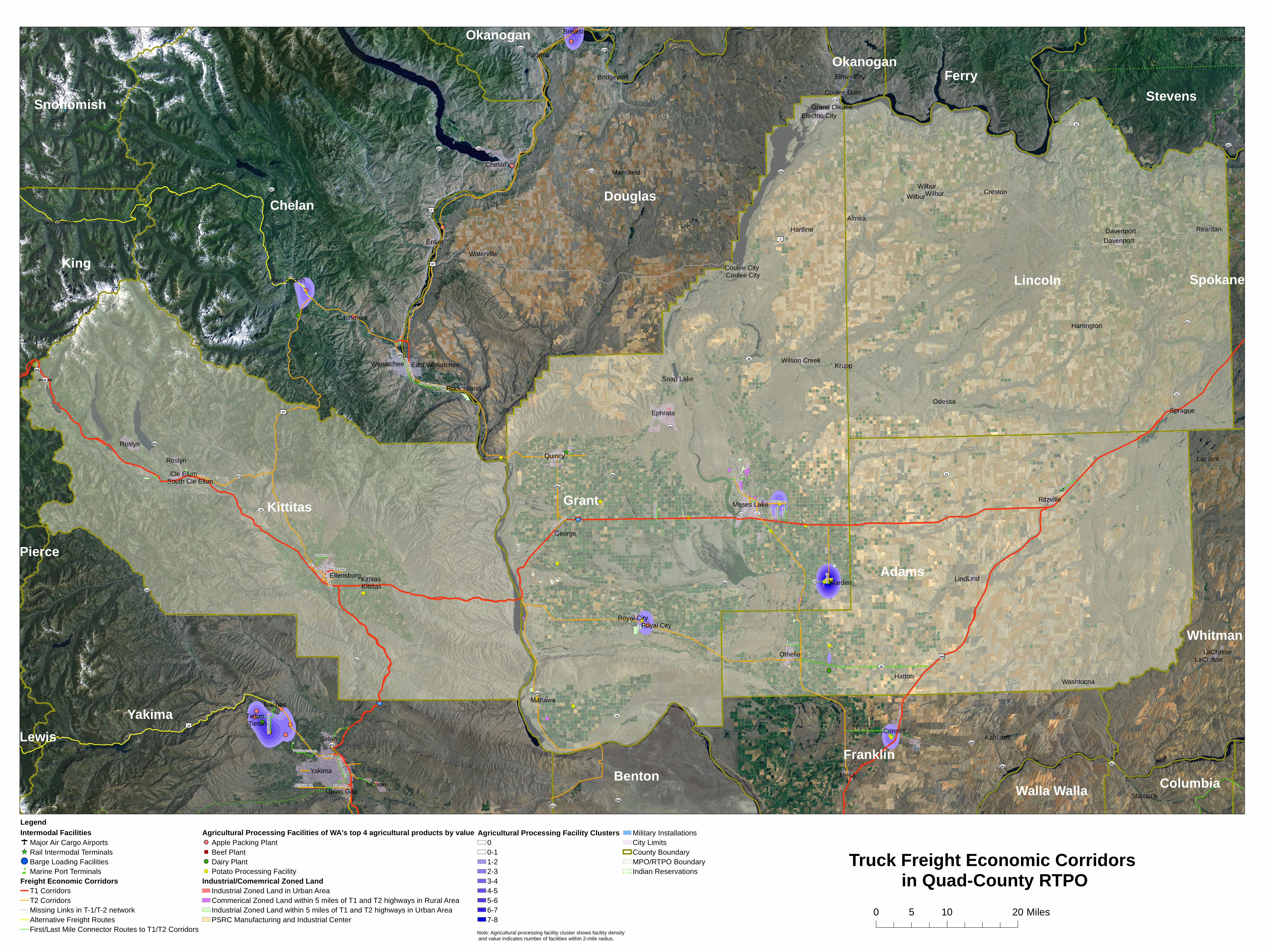
Yakima
Moses Lake
Ephrata
Connell
Chelan
Selah
Quincy
Wenatchee
Ellensburg
Othello
Union Gap
Roslyn
Entiat
Cle Elum
Warden
MoxeeMesa
Lind
East Wenatchee
Electric City
Ritzville
George
Roslyn
Wilbur
Davenport
Tieton
Soap Lake
Cashmere
Bridgeport
Odessa
LaCrosse
Krupp
Grand Coulee
Brewster
Royal City
Naches Mattawa
Leavenworth
Waterville
Kittitas
Almira
Wilson Creek
Sprague
Rock Island
Pateros
Washtucna
Coulee Dam
Coulee City
Reardan
Hatton
Creston
LaCrosse
Kahlotus
Hartline
Lamont
Harrington
Springdale
Mansfield
Skykomish
Wilbur
South Cle Elum
Elmer City
Davenport
Starbuck
Wilbur
Lind
Royal City
Coulee City
Tieton
Kittitas
Grant
Chelan
Kittitas
Lincoln
Adams
Yakima
Douglas
Franklin
King
Ferry
Whitman
Stevens
Benton
Snohomish
Okanogan
ColumbiaWalla Walla
Spokane
Okanogan
Lewis
Pierce
90
82
2
12
395
97
ALT 97
97
28
26
21
17
24
410
174
23
25
260
172
261
243
231
155
821
262
10
283
971
173
281
970
903
153
263
240
150
823
285
282
291
207
171
170
906
241
SPUR 906
LegendIntermodal Facilities
Major Air Cargo AirportsRail Intermodal TerminalsBarge Loading FacilitiesMarine Port Terminals
Freight Economic CorridorsT1 CorridorsT2 CorridorsMissing Links in T-1/T-2 networkAlternative Freight RoutesFirst/Last Mile Connector Routes to T1/T2 Corridors
Agricultural Processing Facilities of WA's top 4 agricultural products by valueApple Packing PlantBeef PlantDairy PlantPotato Processing Facility
Industrial/Comemrical Zoned LandIndustrial Zoned Land in Urban AreaCommerical Zoned Land within 5 miles of T1 and T2 highways in Rural Area Industrial Zoned Land within 5 miles of T1 and T2 highways in Urban Area PSRC Manufacturing and Industrial Center
Agricultural Processing Facility Clusters00-11-22-33-44-55-66-77-8
Military InstallationsCity LimitsCounty BoundaryMPO/RTPO BoundaryIndian Reservations
Truck Freight Economic Corridors in Quad-County RTPO
Note: Agricultural processing facility cluster shows facility density and value indicates number of facilities within 2-mile radius.
0 10 205 Miles