Embed Size (px)
Citation preview
OKLAHOMA SCHOOL TESTING PROGRAM
OKLAHOMA CORE CURRICULUM TESTS
Test and ITEM SPECIFICATIONS
Grade 7 World Geography: Eastern Hemisphere
2013-2014 Edition
Oklahoma State Department of Education Oklahoma City, OK
Revised August 2013

Grade 7 World Geography Test and Item Specifications Oklahoma Core Curriculum Tests (OCCT)| 2
Oklahoma Core Curriculum Tests
TEST AND ITEM SPECIFICATIONS
Table of Contents Purpose .............................................................................................................................................................3
Test Structure, Format, and Scoring ..................................................................................................................4
Test Alignment with Oklahoma Academic Standards .....................................................................................4
Depth of Knowledge Assessed by Test Items ..................................................................................................6
Universal Test Design Considerations .............................................................................................................7
Testing Schedules ............................................................................................................................................7
Multiple-Choice Item Guidelines.....................................................................................................................8
Stimulus Materials ...........................................................................................................................................9
General Considerations ....................................................................................................................................9
Vocabulary .....................................................................................................................................................11
Overview of Item Specifications....................................................................................................................12
Oklahoma Academic Standards .....................................................................................................................13
Item Specifications and Sample Test Items ...................................................................................................18

Grade 7 World Geography Test and Item Specifications Oklahoma Core Curriculum Tests (OCCT)| 3
Purpose The purpose of the Grade 7 World Geography: Eastern Hemisphere Test is to measure Oklahoma students’ level of proficiency. On this test, students are required to respond to a variety of items linked to the seventh-grade geography content standards identified in the Oklahoma Academic Standards (OAS). Each Geography Test form tests each identified content standard and objective listed below. The following standards and objectives are intended to summarize the knowledge as identified in the Oklahoma Academic Standards.
Developed and published under contract with the Oklahoma State Department of Education by CTB/McGraw-Hill LLC, 20 Ryan Ranch Road, Monterey, California 93940-5703. Copyright © 2013 by the Oklahoma State Department of Education. Only State of Oklahoma educators and citizens may copy, download and/or print the document, located online at www.ok.gov/sde/test-support-teachers-and-administrators. Any other use or reproduction of this document, in whole or in part, requires written permission of the Oklahoma State Department of Education and the
publisher.
Oklahoma Academic Standards Standards and Objectives
Geographic Tools/ Geography Skills (1.0) • Geographic Skills & Tools (1.1-1.5) • Freedom Week (1.6)
Human and Physical Characteristics of Regions (2.0) • Political Regions (2.1) • Physical and Cultural Regions (2.2) • Physical and Human Links and Divisions (2.3) • Conflict and Cooperation (2.4) • Change Over Time (2.5) Physical Systems of the Earth (3.0) • Major Landforms and Bodies of Water (3.1) • Impact of Natural Disasters (3.2)
Human Systems (4.0) • Cultural Traits and Diffusion (4.1) • Major Religions (4.2) • Economic Development (4.3) • Comparative Economic Systems (4.4) • Comparative Political Systems (4.5) • Interdependence and World Trade (4.6) • Impact of Geography on Populations (4.7)
Human/ Environment Interactions (5.0) • Resources and Economic Activities (5.1) • Human Modification (5.2) • Problems and Policies with Spatial Dimensions (5.3)

Grade 7 World Geography Test and Item Specifications Oklahoma Core Curriculum Tests (OCCT)| 4
Test Structure, Format, and Scoring The Oklahoma Core Curriculum Tests consist of multiple-choice items. Each multiple-choice item is scored as correct or incorrect. The student’s raw score is converted to a scaled score using the number correct method. Of the total items, 10 items are field-test items and do not contribute to the student’s scaled score.
Content Assessment Total Items Total
Operational Items
Total Field Test Items
Mathematics 50 50 Reading 50 50 Geography 65 50 15
Test Alignment with Oklahoma Academic Standards
Criteria for Aligning the Test with the Oklahoma Academic Standards Standards and Objectives
1. Categorical Concurrence The test is constructed so that there are at least six items measuring each OAS standard. The number of items is based on estimating the number of items that could produce a reasonably reliable estimate of a student’s mastery of the content measured.
2. Depth of Knowledge Consistency The test is constructed using items from a variety of Depth of Knowledge levels that are consistent with the processes students need in order to demonstrate proficiency for each OAS objective.
3. Range of Knowledge Correspondence The test is constructed so that at least 75% of the objectives for an OAS standard have at least one corresponding assessment item.
4. Balance of Representation The test is constructed according to the Test Blueprint which reflects the degree of representation given on the test to each OAS standard and/or OAS objective in terms of the percent of total test items measuring each standard and the number of test items measuring each standard and/or objective. The test construction shall yield a balance of representation with an index of 0.7 or higher of assessed objectives related to a standard.
5. Source of Challenge Each test item is constructed in such a way that the major cognitive demand comes directly from the targeted OAS objective or concept being assessed, not from specialized knowledge or cultural background that the test-taker may bring to the testing situation.
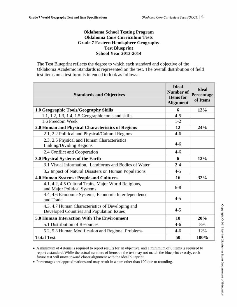
Grade 7 World Geography Test and Item Specifications Oklahoma Core Curriculum Tests (OCCT)| 5
Oklahoma School Testing Program Oklahoma Core Curriculum Tests
Grade 7 Eastern Hemisphere Geography Test Blueprint
School Year 2013-2014
The Test Blueprint reflects the degree to which each standard and objective of the Oklahoma Academic Standards is represented on the test. The overall distribution of field test items on a test form is intended to look as follows:
Standards and Objectives
Ideal Number of Items for
Alignment
Ideal Percentage
of Items
1.0 Geographic Tools/Geography Skills 6 12% 1.1, 1.2, 1.3, 1.4, 1.5 Geographic tools and skills 4-5 1.6 Freedom Week 1-2
2.0 Human and Physical Characteristics of Regions 12 24% 2.1, 2.2 Political and Physical/Cultural Regions 4-6 2.3, 2.5 Physical and Human Characteristics Linking/Dividing Regions
4-6
2.4 Conflict and Cooperation 4-6 3.0 Physical Systems of the Earth 6 12%
3.1 Visual Information, Landforms and Bodies of Water 2-4 3.2 Impact of Natural Disasters on Human Populations 4-5
4.0 Human Systems: People and Cultures 16 32% 4.1, 4.2, 4.5 Cultural Traits, Major World Religions, and Major Political Systems
6-8
4.4, 4.6 Economic Systems, Economic Interdependence and Trade
4-5
4.3, 4.7 Human Characteristics of Developing and Developed Countries and Population Issues
4-5
5.0 Human Interaction With The Environment 10 20% 5.1 Distribution of Resources 4-6 8% 5.2, 5.3 Human Modification and Regional Problems 4-6 12%
Total Test 50 100%
• A minimum of 4 items is required to report results for an objective, and a minimum of 6 items is required to report a standard. While the actual numbers of items on the test may not match the blueprint exactly, each future test will move toward closer alignment with the ideal blueprint.
• Percentages are approximations and may result in a sum other than 100 due to rounding.

Grade 7 World Geography Test and Item Specifications Oklahoma Core Curriculum Tests (OCCT)| 6
Depth of Knowledge Assessed by Test Items The Oklahoma Core Curriculum Tests will, as closely as possible, reflect the following “Depth of Knowledge” distribution of items.
Grades 3-5 Depth of Knowledge Percent of Items
Level 1—Recall and Reproduction 20-25%
Level 2—Skills and Concepts 65-70%
Level 3—Strategic Thinking 5-15%
Grades 6-8 Depth of Knowledge Percent of Items
Level 1—Recall and Reproduction 10-15% Level 2—Skills and Concepts 65-70% Level 3—Strategic Thinking 15-25%
Level 1 (Recall and Reproduction) asks students to recall facts, terms, concepts, and trends or to recognize or identify specific information contained in graphics. This level generally requires students to identify, list, or define. The items at this level usually ask the student to recall who, what, when, and where. Items that require students to “describe” and/or “explain” could be classified at Level 1 or Level 2, depending on what is to be described and/or explained. A Level 1 “describe and/ or explain” would require students to recall, recite, or reproduce information. Items that require students to recognize or identify specific information contained in documents, excerpts, quotations, maps, charts, tables, graphs, or illustrations are generally Level 1. Level 2 (Skills and Concepts) includes the engagement of some mental processing beyond recalling or reproducing a response. This level generally requires students to: contrast or compare people, places, events, and concepts; convert information from one form to another; give an example; classify or sort items into meaningful categories; draw simple conclusions; or describe, interpret, or explain issues and problems, patterns, reasons, cause and effect, significance or impact, relationships, points of view, or processes. A Level 2 “describe and/or explain” would require students to go beyond a description or explanation of recalled information to describe and/or explain a result or “how” or “why.” Level 3 (Strategic and Extended Thinking) requires reasoning, using evidence, and a higher level of thinking than Level 1 and Level 2. Students will go beyond explaining or describing “how and why” to justifying the “how and why” through application and evidence. The cognitive demands at Level 3 are more complex and more abstract than Level 1 or Level 2. Items at Level 3 can include: drawing conclusions from multiple or complex stimuli; citing evidence; applying concepts to new situations; using concepts to solve problems; analyzing similarities and differences in issues and problems; proposing and evaluating solutions to problems; recognizing and explaining

Grade 7 World Geography Test and Item Specifications Oklahoma Core Curriculum Tests (OCCT)| 7
misconceptions; or making connections across time and place to explain a concept or “big idea.” Items may require planning, investigating, or developing. At this level, the cognitive demands may be high, the work may be very complex, and students may be required to: connect and relate ideas and concepts within the content area; analyze and synthesize information from multiple sources; examine and explain alternative perspectives across a variety of sources; and/or describe and illustrate how common themes and concepts are found across time and place. Students may make predictions with evidence as support. Note — The descriptions are adapted from Review Background Information and Instructions, Standards and Assessment Alignment Analysis, CCSSO TILSA Alignment Study, May 21-24, 2001, Version 2.0.
Universal Test Design Considerations Universal design, as applied to assessments, is a concept that allows the widest possible range of students to participate in assessments and may even reduce the need for accommodations and alternative assessments by expanding access to the tests themselves. In the Oklahoma Core Curriculum Tests, modifications have been made to some items that simplify and clarify instructions, and provide maximum readability, comprehensibility, and legibility. This includes such things as reduction of language load in content areas other than Reading, increased font size, fewer items per page, and boxed items to assist visual focus. Reading tests will have vocabulary at grade level. In all other tests, the vocabulary level will be below the grade being tested except for content words. Grades 3 and 4 will be one grade level below, and grades 5, 6, 7, and 8 will be two grade levels below. These modifications are evident in the sample items included in this document.
Testing Schedules At grades 6, 7 and 8, each subject area test is meant to be administered in a separate session. Students may be given additional time if needed, but additional time will be given as an extension of the same testing period, not at a different time. Grade 7 Mathematics
Test Session Approximately Distributing books, filling in the Student Demographic Page, reading directions………………20 minutes Administering the Test…………………………...60-80 minutes no calculators are allowed during this test
Total: …………………...…………………........ 80-100 minutes

Grade 7 World Geography Test and Item Specifications Oklahoma Core Curriculum Tests (OCCT)| 8
Multiple-Choice Item Guidelines
• All item stems clearly indicate what is expected in an item to help students focus on selecting a response.
• Each multiple-choice item has a stem (question, statement, or incomplete statement, and/or graphic component) and four answer (or completion) options, only one of which is correct.
• Multiple-choice item stems present a complete problem so that students know what to do before looking at the answer choices; students should not need to read all answer choices before knowing what is expected.
• Art incorporated within an item must be functional and assist students in determining the correct response.
In summary, test items assess whether students: understand relevant concepts and procedures; communicate their understandings effectively in content specific terms; approach problems; and develop viable solutions.
Grade 7 Reading Test Session Approximately Distributing books, filling in the Student Demographic Page, reading directions………………15 minutes Administering the Test………………………….95-115 minutes Total: …………………...…………………..... 110-130 minutes
Grade 7 Geography
Test Session Approximately Distributing books, filling in the Student Demographic Page, reading directions………………20 minutes Administering the Test…………………………...60-80 minutes
Total: …………………...…………………........ 80-100 minutes
Grade 7 World Geography Test and Item Specifications Oklahoma Core Curriculum Tests (OCCT)| 9
Stimulus Materials
Stimulus materials are the Oklahoma Academic Standards passages, graphs, models, figures, etc. that students must read and examine in order to respond to items. The following characteristics are necessary for stimulus materials: 1. When students are given information, data, or an experimental setup to evaluate, they should know
the research question and the purpose of the research. 2. Tables, graphs, reading Oklahoma Academic Standards passages, and illustrations provide
sufficient information for assessment of multiple standards. 3. Stimulus materials for a set of items may be a combination of multiple stimuli. 4. Information in stimulus materials is representative of concepts and principles described in
Oklahoma Academic Standards. 5. For conceptual items, stimulus materials are necessary but not conceptually sufficient for student
response. 6. There is a balance of graphic and textual stimulus materials within a test form. At least 50% of the
items have appropriate pictorial and graphical representations. Graphs, tables, or figures are clearly associated with their intended items. Graphics appear either on the same page as the stimulus or on the facing page.
7. The stimuli avoid subject matter that might prompt emotional distress on the part of the students. 8. Permission to use stimuli from copyrighted material is obtained as necessary by the testing
vendor.
General Considerations It is necessary to create test items that are reliable, fair, and targeted to the Oklahoma Academic Standards listed on the following pages. There are some general considerations and procedures for effective item development. These considerations include, but are not limited to, the following: 1. Each test form contains items assessing standards and objectives listed in the Test Blueprint for the
specific grade and content area. In the Oklahoma Academic Standards document, asterisks have been used to identify standards and objectives that must be assessed by the local school district.
2. Test items that assess each standard are not limited to one particular type of response format. Each item begins with a stem that asks a question or poses a clear problem. Stems may include incomplete sentences in order to reduce unnecessary repetition of text.
3. Test items attempt to focus on content that is authentic and that grade-level students can relate to and understand.
4. Test items are worded precisely and clearly. The more focused an item, the more reliable and fair it will be, and the more likely all students will understand what is required of them.

Grade 7 World Geography Test and Item Specifications Oklahoma Core Curriculum Tests (OCCT)| 10
5. All items are reviewed to eliminate language that is biased or is otherwise likely to disadvantage a particular group of students. That is, items do not display unfair representations of gender, race, ethnicity, disability, culture, or religion; nor do items contain elements that are offensive to any such groups.
6. All multiple-choice items, including the correct response and distractors, are similar in length and syntax. Students should not be able to rule out a wrong answer or identify a correct response solely because it looks or sounds different from the other answer choices. Distractors are created so that students reason their way to the correct answer rather than simply identify incorrect responses because of a distractor’s obviously inappropriate nature. Distractors should always be plausible (but incorrect) in the context of the item stem. Correct responses are reasonably distributed among A’s, B’s, C’s, and D’s. The distractors adopt the language and sense of the material in the selection. Test items focus on reading skills and comprehension strategies, avoiding measurement of a student’s feelings or values.
7. Items deal with issues and details that are of consequence in the stimulus and central to students’ understanding and interpretation of the stimulus.
8. To the greatest extent possible, no item or response choice clues the answer to any other item. No item stem or answer option provides clues to any other item’s answer, nor is the same fact of the Oklahoma Academic Standards assessed more than once, including the same vocabulary or technical term.
9. Test items are tied closely and particularly to the stimuli from which they derive, so that the impact of outside (prior) knowledge, while never wholly avoidable, is minimized.
10. The responses “Both of the above,” “All of the above,” “None of the above,” and “Neither of the above” are not used.
11. All stems are positively worded—avoiding the use of the word not. 12. The material presented is balanced, culturally diverse, well-written, and of interest to students. The
stimuli and items are presented fairly in order to gain a true picture of students’ skills. 13. Across all forms, a balance of gender and active/ passive roles by gender is maintained. 14. No resource materials or calculators may be used by students during the test.

Grade 7 World Geography Test and Item Specifications Oklahoma Core Curriculum Tests (OCCT)| 11
Vocabulary
No single source is available to determine the reading level of various words. Therefore, the appropriateness and difficulty of a word is determined in various ways. Vocabulary words are checked in the following: EDL Core Vocabularies in Reading, Mathematics, Science, and Social Studies; Basic Reading Vocabularies; the Living Word; or other reliable readability sources. In addition to using the aforementioned printed resources to assist in creating vocabulary items, each vocabulary item must be approved by Oklahoma’s Content Review Committee. The committee comprised of Oklahoma educators from across the state, reviews proposed vocabulary items for grade level appropriateness. Reading tests will have vocabulary at grade level. In all other tests, the vocabulary level will be below the grade being tested except for content words. Grades 3 and 4 will be one grade level below, and grades 5, 6, 7, and 8 will be two grade levels below.
All items developed using these specifications are reviewed by Oklahoma educators and approved by the Oklahoma State Department of Education. The distribution of newly developed items is based on content and process alignment, difficulty, cognitive ability, percentage of art/graphics, and grade-level appropriateness as determined by an annual Item Development Plan approved by the Oklahoma State Department of Education.
Grade 7 World Geography Test and Item Specifications Oklahoma Core Curriculum Tests (OCCT)| 12
Overview of Item Specifications
For each, item specifications are organized under the following headings:
OAS Standard OAS Objective Item Specifications Emphasis Stimulus Attributes Format Content Limits Distractor Domain Sample Test Items
The headings “OAS Standard” and “OAS Objective” state the standard and objective being measured as found in the Grade 5 Social Studies section of the Oklahoma Academic Standards document.
The heading “Item Specifications” highlights important points about the items’ emphasis, stimulus attributes, format, content limits, distractor domain, and sample test items. Although it is sometimes possible to score single items for more than one concept, all items in these tests are written to address a single content standard as the primary concept.
Note about the Item Specifications and Sample Test Items: With the exception of content limits, the item specifications give suggestions of what might be included but do not give an exhaustive list of what can be included. The sample test items are not intended to be definitive in nature or construction—the stimuli and the test items that follow them may differ from one test form to another, as may their presentations.
Grade 7 World Geography Test and Item Specifications Oklahoma Core Curriculum Tests (OCCT)| 13
Oklahoma Academic Standards
World Geography: Eastern Hemisphere Grade 7
Geography is composed of the interrelated components of skills and content knowledge, both of which are necessary to being a geographically informed citizen. Students will use geographic knowledge as a tool for understanding the concepts of economics and the impact of recent history on contemporary events. Students will focus on the spatial patterns of human and physical characteristics of the world and in peoples, and will explore how these patterns form, change over time, and relate to one another in the Eastern Hemisphere. This is the second half of the middle level geographic studies program. The Western Hemisphere was the focus of the Grade 6 portion. For practical uses the traditional designation of the Eastern and Western Hemisphere has been followed. The Eastern Hemisphere is treated as the areas of Africa, Asia, Europe, Australia, and Oceania.
Standard 1: The student will analyze data from a geographic perspective using the skills and tools of geography.
1. Cite specific geographic information to support analysis from primary and secondary sources located in texts, documents, newspapers, magazines, journals, political cartoons, and online news sources.
2. Integrate visual information, draw conclusions, and make predictions from geographic data and analyze spatial distribution and patterns by interpreting that data as displayed on globes, graphs, charts, satellite and other forms of visual imagery including data from bar and line graphs, pie charts, thematic maps, population pyramids, climographs, cartograms, contour/relief maps, GIS systems, and diagrams.
3. Apply the concepts of scale, distance, direction, relative location, absolute location, and latitude and longitude.
4. Integrate visual information and apply the skill of mental mapping of the political and physical features of Earth’s surface and to organize information about people, places, and environments.
5. Conduct short research projects by investigating contemporary events and issues from political, economic, social, and geographic perspectives.
6. Commemorate Celebrate Freedom Week by recognizing the sacrifices and contributions to American freedom by veterans and by reciting the social contract selection from the Declaration of Independence:
We hold these trusts to be self-evident, that all men are created equal, that they are endowed by their Creator with certain unalienable Rights, that among these are Life, Liberty and the pursuit of Happiness. --That to secure these rights, Governments are instituted among Men, deriving their just powers from the consent of the governed.
Standard 2: The student will examine the human and physical characteristics of the major regions of the Eastern Hemisphere. 1. Integrate visual information in order to describe specific political regions of the Eastern
Hemisphere, and identify on a political map the major urban areas and countries including
Grade 7 World Geography Test and Item Specifications Oklahoma Core Curriculum Tests (OCCT)| 14
Europe—London/United Kingdom, Paris/France, Rome/Italy, Berlin/Germany, and Moscow/Russia,
A. Southwest Asia—Mecca/Saudi Arabia, Jerusalem/Israel, Tehran/Iran, Beirut/ Lebanon, and Bagdad/Iraq,
B. South Asia—Mumbai/India, Pakistan, Afghanistan, C. East and Southeast Asia—Beijing/China, Seoul/South Korea, Tokyo/Japan, Indonesia,
Vietnam, and Malaysia, D. Africa—Cairo/Egypt, Nairobi/Kenya, South Africa, Libya, Sudan, and Nigeria, and E. Oceania—Australia and New Zealand.
2. Integrate visual information in order to describe the characteristics and relative location of physical and cultural regions of the Eastern Hemisphere including A. Physical Regions—
1) Sub-Saharan savannas and rainforests, 2) Pacific Ring of Fire, 3) Rhine-Danube industrial corridor, and 4) The Himalayan Mountain Range.
B. Cultural Regions— 1) The Sahel’s and Sahara’s nomadic peoples, 2) Jerusalem’s religious significance to Judaism, Christianity, and Islam, and 3) The cultural hearths of the Nile, Indus, Ganges, Hwang He River Valleys, and
Mesopotamia. 3. Explain and summarize how common physical or human characteristics can link as well as
divide regions including A. Extensive inland waterway systems of natural rivers and manmade canals that link European
trading centers, B. Ural Mountains that physically divide Europe from Asia, C. Sahara Desert that physically and culturally divides North Africa from Sub-Sahara Africa, D. Multiple languages, religion, and the legacy of the caste system in India that present barriers
to cultural unity, and E. Cultural differences resulting in civil war and genocide in Darfur and Rwanda.
4. Cite specific textual and visual evidence to analyze reasons for conflict and cooperation among groups, societies, countries, and regions of the Eastern Hemisphere and the involvement of multinational organizations of the United Nations and the North Atlantic Treaty Organization including A. Multinational peace-keeping efforts to stabilize Arab-Israeli relations, B. Roots of disputes between India and Pakistan resulting in the threat of conventional war and
nuclear war, C. Impact of multiple ethnic groups on Nigerian political stability, D. Coordination of currency and free trade zones created by the European Union, E. Humanitarian relief efforts by the United Nations to address hunger in Africa, and F. The struggle for and achievement of civil liberties and economic opportunities in South
Grade 7 World Geography Test and Item Specifications Oklahoma Core Curriculum Tests (OCCT)| 15
Africa’s post-apartheid era. 5. Explain and summarize how and why regions change over time through physical and human
processes which operate to modify Earth’s surface including the A. Cultural diffusion brought about by North Africa’s location central to trade across multiple
continents, B. Impact of overgrazing and drought leading to desertification in the Sahel, C. Results of the Green Revolution in Central Asia, and D. Effects of abundant oil supplies in the Persian Gulf region.
Standard 3: The student will examine the interactions of physical systems that shape the patterns of the Earth’s surface in the Eastern Hemisphere.
1. Integrate visual information to identify on a physical map and describe the major landforms and bodies of water including A. Landforms—the Iberian, Scandinavian, and Indochina Peninsulas: the Urals, Pyrenees, Alps,
and Himalayan Mountain Ranges; the Sahara Kalahari, and Gobi Deserts; and the Great Rift Valley.
B. Bodies of water—Danube, Volga, Nile, Congo, Niger, Tigris, Euphrates, Indus, Ganges, and Yangtze Rivers; Mediterranean, Arabian and North Seas; Persian Gulf; Bay of Bengal; Strait of Gibraltar; Atlantic, Arctic, Indian, Pacific, and the Southern Oceans.
2. Analyze from multiple perspectives the impact of natural disasters on human populations resulting in forced migration, scarcity of consumer goods, and loss of employment including A. The impact of plate tectonics resulting in earthquakes, tsunamis, and volcanic eruptions on
human and physical systems bordering the Pacific Ring of Fire, B. Frequent drought of northern Africa and Southwest Asia that creates stress on humans and
wildlife, C. The impact of monsoon patterns and typhoon activity on agriculture and loss of life in South
Asia, and D. Regular flooding of China’s rivers resulting in the accumulation of loess.
Standard 4: The student will analyze the world’s peoples and cultures in the context of the human systems in the Eastern Hemisphere.
1. Compare and contrast the common cultural traits including language, ethnic heritage, social systems, religions, and traditions and how cultural diffusion impacts societies.
2. Describe the world’s major religions including Buddhism, Christianity, Daoism, Hinduism, Islam, and Judaism including the geographic origins, major beliefs, and customs of the five major world religions and the significance of religion in contemporary societies.
3. Integrate visual information to analyze data used by geographers to measure the human characteristics used to define developed versus developing countries including literacy rates, life expectancy, infant mortality rate, Gross National Product (GNP), and per capita income.
4. Compare and contrast the market and command economics systems and how governments affect economic activities in such systems including
Grade 7 World Geography Test and Item Specifications Oklahoma Core Curriculum Tests (OCCT)| 16
Economic reforms in China that are moving China from a command system toward a market system,
A. The economic advantages and disadvantages of Sweden’s mixed market system, B. The economic prosperity generated by Japan’s market system, and C. The economic development limitations of North Korea’s command economic system.
5. Compare and contrast the major political systems of representative governments (democracy, republic, and constitutional monarchy) and authoritarian systems (dictatorship and absolute monarchy) including the role of the citizen in the selection of government officials, lawmaking, and the liberties guaranteed under different forms of government. A. The symbolic role of the British crown in comparison to the absolute authority of the
monarchy of Saudi Arabia. B. The transformation of the former Soviet Union from an authoritarian system to the limited
representative democracy of Russia. 6. Integrate visual information to explain patterns of global economic interdependence and world trade
focusing on the concepts of imports and exports, supply and demand, Gross Domestic Product (GDP), and the balance of trade including A. The European Union’s single currency and open single market that link economies and
governments, B. The relative isolation of Japan and the United Kingdom that require extensive trade patterns
for natural resources and markets, C. Outsourcing of technological and manufacturing jobs to developing regions of Asia, and D. Control over production and supply of global oil reserves as exercised by the Oil Producing
and Exporting Countries (OPEC). 7. Evaluate and summarize the impact of geography on population location, growth, change and
density and on the availability of resources, settlement patterns, and migration including the A. Impact of push and pull factors on the rural migration to overcrowded urban centers in India, B. Challenges of under-population on the labor market in developed nations of Europe, C. Changing face of European cultures as a result of recent patterns of immigration, and D. Impact of China’s one-child policy on population growth and culture.
Standard 5: The student will analyze the interactions of humans and their environment in the Eastern Hemisphere.
1. Cite specific textual and visual evidence to describe the relationship between the distribution of major renewable and nonrenewable resources and evaluate how the three levels of economic activities (primary, secondary, and tertiary) contribute to the development of a country or region including the A. Abundant energy resources driving China’s rapid development, B. Reserves of valuable minerals responsible for South Africa’s economic growth, C. Accessibility of coal and iron reserves contributing to steel industries of Western Europe and
Russia, and D. Value of North Sea petroleum reserves to developed nations’ economies.

Grade 7 World Geography Test and Item Specifications Oklahoma Core Curriculum Tests (OCCT)| 17
2. Evaluate the effects of human modification of and adaptation to the natural environment including the A. Deforestation of Indonesia’s rainforests, B. Creation of living space through the drainage of seawater and the system of dikes in the
Netherlands, C. Transformation of arid lands of the Arabian Peninsula through the introduction of western
irrigation methods, D. Use of terrace farming and double-cropping as solutions to food needs of East Asia, and E. Benefits and dangers of nuclear power generation as exemplified by the environmental
disaster at Chernobyl. 3. Integrate visual information to analyze regional problems and policies having spatial dimensions in
the Eastern Hemisphere including A. the Management of the Aral Sea’s water resources B. Impact of the economic development of Russia’s Arctic regions, and C. Transformation of the environment and population centers caused by the construction of the
Three Gorges Dam in China
Grade 7 World Geography Test and Item Specifications Oklahoma Core Curriculum Tests (OCCT)| 18
Item Specifications and Sample Test Items OAS Standard: Standard 1: The student will analyze data from a geographic perspective using the skills and tools of geography.
OAS Objective: 1. Cite specific geographic information to support analysis from primary and secondary sources
located in texts, documents, newspapers, magazines, journals, political cartoons, and online news sources.
Item Specifications: Emphasis: • Analyze geographic information from given data. Stimulus Attributes: • Test items may include:
o Charts, tables, diagrams, graphs o Media (political cartoons, photographs, and advertisements) o Literature (diaries, journals, newspapers/magazines, quotations, speeches, and letters) o Geographical tools (maps, globes, atlases, satellite images, and almanacs) o Population pyramids o Cartograms o Cultural interacting with and adapting to physical environments o At least 50 percent of the items are to have appropriate pictorial and graphical representations.
Format: • Items require students to make conclusions based on personal knowledge and from readings,
graphs, charts, and other source material provided. Content Limits: • Item should contain informational text from a source below to support information garnered
from primary and secondary sources [two stimuli for this objective]: o newspaper and magazine articles o journals, political cartoons o online news sites o charts, graphs, tables, maps, atlases, or almanacs
Distractor Domain: • Incorrect answer choices include information related to source materials but irrelevant to the
question being asked. Distractors may reflect a plausible misunderstanding of the question or concept. Some items may have similar geographic forms/terms to compare and contrast.
Grade 7 World Geography Test and Item Specifications Oklahoma Core Curriculum Tests (OCCT)| 19
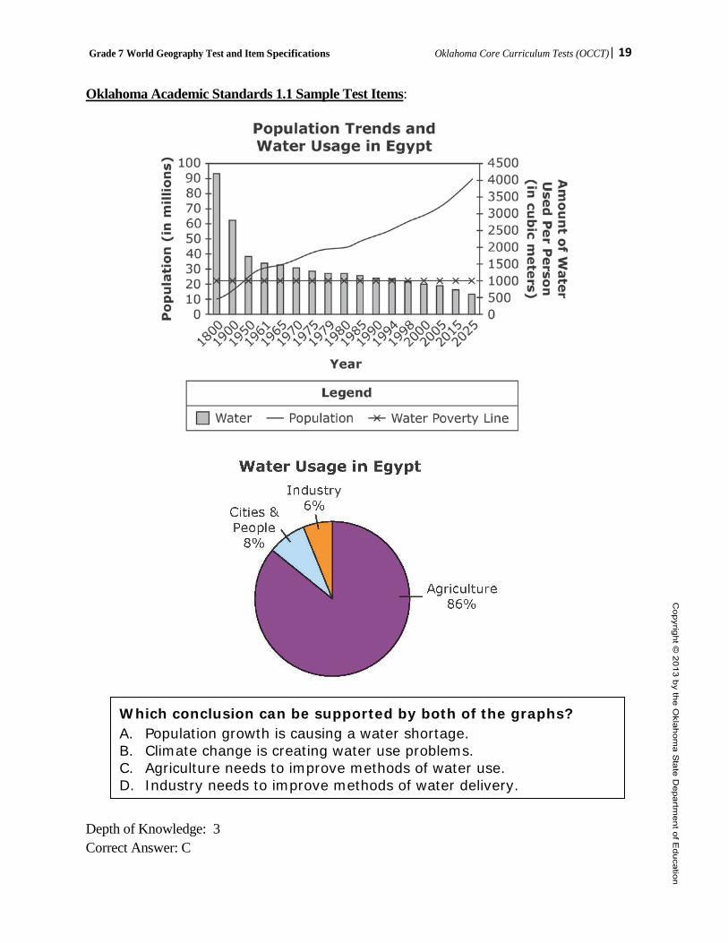
Oklahoma Academic Standards 1.1 Sample Test Items:
Depth of Knowledge: 3 Correct Answer: C
Which conclusion can be supported by both of the graphs? A. Population growth is causing a water shortage. B. Climate change is creating water use problems. C. Agriculture needs to improve methods of water use. D. Industry needs to improve methods of water delivery.
Grade 7 World Geography Test and Item Specifications Oklahoma Core Curriculum Tests (OCCT)| 20
OAS Standard: Standard 1: The student will analyze data from a geographic perspective using the skills and tools of geography.
OAS Objective: 2. Integrate visual information, draw conclusions, and make predictions from geographic data and
analyze spatial distribution and patterns by interpreting that data as displayed on globes, graphs, charts, satellite and other forms of visual imagery including data from bar and line graphs, pie charts, thematic maps, population pyramids, climographs, cartograms, contour/relief maps, GIS systems, and diagrams.
Item Specifications:
Emphasis: • Draw conclusions and make predictions from geographic data • Analyze spatial distribution and pattern
Stimulus Attributes: • Test items may include:
o Charts, tables, diagrams, graphs o Media (political cartoons, photographs, and advertisements) o Literature (diaries, journals, newspapers/magazines, quotations, speeches, and letters) o Geographical tools (maps, globes, atlases, satellite images, and almanacs) o Population pyramids o Cartograms o Cultural interacting with and adapting to physical environments o At least 50 percent of the items are to have appropriate pictorial and graphical representations.
Format: • Items require students to make conclusions based on personal knowledge and from readings,
graphs, charts, and other source material provided.
Content Limits: • Questions written to this standard require at least one stimulus.
Distractor Domain: • Incorrect answer choices include information related to source materials but irrelevant to the
question being asked. Distractors may reflect a plausible misunderstanding of the question or concept. Some items may have similar geographic forms/terms to compare and contrast.
Grade 7 World Geography Test and Item Specifications Oklahoma Core Curriculum Tests (OCCT)| 21
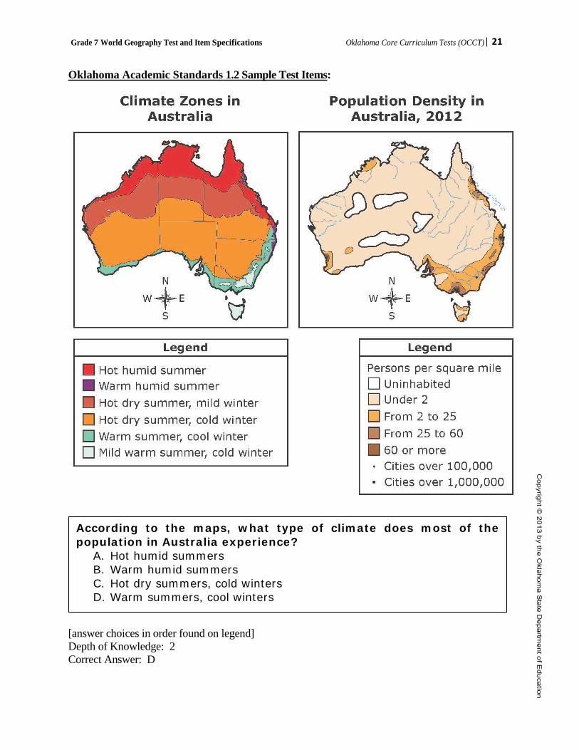
Oklahoma Academic Standards 1.2 Sample Test Items:
[answer choices in order found on legend] Depth of Knowledge: 2 Correct Answer: D
According to the maps, what type of climate does most of the population in Australia experience?
A. Hot humid summers B. Warm humid summers C. Hot dry summers, cold winters D. Warm summers, cool winters

Grade 7 World Geography Test and Item Specifications Oklahoma Core Curriculum Tests (OCCT)| 22
OAS Standard: Standard 1: The student will analyze data from a geographic perspective using the skills and tools of geography.
OAS Objective: 3. Apply the concepts of scale, distance, direction, relative location, absolute location, and latitude
and longitude. Item Specifications:
Emphasis: • Assess map reading and orientation skills.
Stimulus Attributes: • Test items may include:
o Charts, tables, diagrams, graphs o Media (political cartoons, photographs, and advertisements) o Literature (diaries, journals, newspapers/magazines, quotations, speeches, and letters) o Geographical tools (maps, globes, atlases, satellite images, and almanacs) o Population pyramids o Cartograms o Cultural interacting with and adapting to physical environments o At least 50 percent of the items are to have appropriate pictorial and graphical representations.
Format: • Items require students to make conclusions based on personal knowledge and from readings,
graphs, charts, and other source material provided.
Content Limits: • Questions written to this standard require at least one stimulus. • Maps: physical, political, thematic
Distractor Domain: • Incorrect answer choices include information related to source materials but irrelevant to the
question being asked. Distractors may reflect a plausible misunderstanding of the question or concept. Some items may have similar geographic forms/terms to compare and contrast.

Grade 7 World Geography Test and Item Specifications Oklahoma Core Curriculum Tests (OCCT)| 23
Oklahoma Academic Standards 1.3 Sample Test Items:
Source: CIA World Factbook
Depth of Knowledge: 2 Correct Answer: A
Which city is closest to the coordinates 18°N, 72°E? A. Mumbai B. Agra C. Chennai D. Kolkata

Grade 7 World Geography Test and Item Specifications Oklahoma Core Curriculum Tests (OCCT)| 24
Depth of Knowledge: 2 Correct Answer: B
• North of Sudan • West of Saudi Arabia • South of the Mediterranean Sea
Which geographic concept is best described by this list?
A. absolute location B. relative location C. longitude D. latitude
Grade 7 World Geography Test and Item Specifications Oklahoma Core Curriculum Tests (OCCT)| 25
OAS Standard: Standard 1: The student will analyze data from a geographic perspective using the skills and tools of geography.
OAS Objective: 4. Integrate visual information and apply the skill of mental mapping of the political and physical
features of Earth’s surface and to organize information about people, places, and environments. Item Specifications:
Emphasis: • Apply mental mapping skills to identify physical and cultural regions.
Stimulus Attributes: • Test items may include:
o Charts, tables, diagrams, graphs o Media (political cartoons, photographs, and advertisements) o Literature (diaries, journals, newspapers/magazines, quotations, speeches, and letters) o Geographical tools (maps, globes, atlases, satellite images, and almanacs) o Population pyramids o Cartograms o Cultural interacting with and adapting to physical environments o At least 50 percent of the items are to have appropriate pictorial and graphical representations.
Format: • Items require students to make conclusions based on personal knowledge and from readings,
graphs, charts, and other source material provided. Content Limits: • Questions written to this standard require at least one stimulus. • Maps: physical, political, thematic Distractor Domain: • Incorrect answer choices include information related to source materials but irrelevant to the
question being asked. Distractors may reflect a plausible misunderstanding of the question or concept. Some items may have similar geographic forms/terms to compare and contrast.

Grade 7 World Geography Test and Item Specifications Oklahoma Core Curriculum Tests (OCCT)| 26
Oklahoma Academic Standards 1.4 Sample Test Items: Which region exports the most oil?
A. North America B. South America C. Southwest Asia D. Northwest Africa
Depth of Knowledge: 1 Correct Answer: C Which number shows the location of a country ruled by a monarchy?
A. 1 B. 2 C. 3 D. 4
Depth of Knowledge: 2 Correct Answer: B

Grade 7 World Geography Test and Item Specifications Oklahoma Core Curriculum Tests (OCCT)| 27
OAS Standard:
Standard 1: The student will analyze data from a geographic perspective using the skills and tools of geography.
OAS Objective: 5. Conduct short research projects by investigating contemporary events and issues from political,
economic, social, and geographic perspectives. Item Specifications:
Emphasis: • Understand, compare, and contrast contemporary events and issues from political, economic,
social, or geographic data
Stimulus Attributes: • Test items may include:
o Charts, tables, diagrams, graphs o Media (political cartoons, photographs, and advertisements) o Literature (diaries, journals, newspapers/magazines, quotations, speeches, and letters) o Geographical tools (maps, globes, atlases, satellite images, and almanacs) o Population pyramids o Cartograms o Cultural interacting with and adapting to physical environments o At least 50 percent of the items are to have appropriate pictorial and graphical representations.
Format: • Items require students to make conclusions based on personal knowledge and from readings,
graphs, charts, and other source material provided. Content Limits: • Questions written to this standard require at least one stimulus. Distractor Domain: • Incorrect answer choices include information related to source materials but irrelevant to the
question being asked. Distractors may reflect a plausible misunderstanding of the question or concept. Some items may have similar geographic forms/terms to compare and contrast.

Grade 7 World Geography Test and Item Specifications Oklahoma Core Curriculum Tests (OCCT)| 28
Oklahoma Academic Standards 1.5 Sample Test Items:
Climate Impacts of Deforestation
Source: http://earthobservatory.nasa.gov/Features/Deforestation/deforestation_update2.php
Depth of Knowledge: 2 Correct Answer: A
Up to thirty percent of the rain that falls in tropical forests is water that the rainforest has recycled into the atmosphere. Water evaporates from the soil and vegetation, condenses into clouds, and falls again as rain in a perpetual self-watering cycle. In addition to maintaining tropical rainfall, the evaporation cools the Earth’s surface.
—excerpt from “Tropical Deforestation” by Rebecca Lindsey, March 30, 2007
According to the information, which conclusion can be made?
A. Tropical rainforests help to slow global warming. B. Tropical rainforests are the only type of forest that can affect climate. C. The temperature of an area is entirely dependent upon tropical rainforests. D. The amount of rain that falls in an area depends upon the size of the
tropical rainforest.
Grade 7 World Geography Test and Item Specifications Oklahoma Core Curriculum Tests (OCCT)| 29
OAS Standard: Standard 1: The student will analyze data from a geographic perspective using the skills and tools of geography.
OAS Objective: 6. Commemorate Celebrate Freedom Week by recognizing the sacrifices and contributions to
American freedom by veterans and by reciting the social contract selection from the Declaration of Independence:
We hold these truths to be self-evident, that all men are created equal, that they are endowed by their Creator with certain unalienable Rights, that among these are Life, Liberty and the pursuit of Happiness. – That to secure these rights, Governments are instituted among Men, deriving their just powers from the consent of the governed.
Item Specifications:
Emphasis: • Understand and recall the social contract found in the Declaration of Independence • Understand how the social contract has been preserved and protected by the American military
when necessary.
Stimulus Attributes: • Test items may include:
o Charts, tables, diagrams, graphs o Media (political cartoons, photographs, and advertisements) o Literature (diaries, journals, newspapers/magazines, quotations, speeches, and letters) o Geographical tools (maps, globes, atlases, satellite images, and almanacs) o Population pyramids o Cartograms o Cultural interacting with and adapting to physical environments o At least 50 percent of the items are to have appropriate pictorial and graphical representations.
Format: • Items require students to make conclusions based on personal knowledge and from readings,
graphs, charts, and other source material provided.
Content Limits: • Contemporary involvement in the Eastern Hemisphere. • Items to this standard should focus on geographic issues relating to the content and NOT
history.
Distractor Domain: • Incorrect answer choices include information related to source materials but irrelevant to the
question being asked. Distractors may reflect a plausible misunderstanding of the question or concept. Some items may have similar geographic forms/terms to compare and contrast.
Grade 7 World Geography Test and Item Specifications Oklahoma Core Curriculum Tests (OCCT)| 30
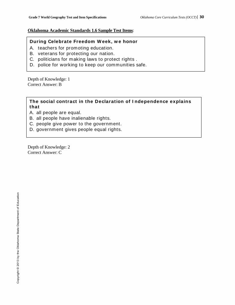
Oklahoma Academic Standards 1.6 Sample Test Items: Depth of Knowledge: 1 Correct Answer: B Depth of Knowledge: 2 Correct Answer: C
During Celebrate Freedom Week, we honor A. teachers for promoting education. B. veterans for protecting our nation. C. politicians for making laws to protect rights . D. police for working to keep our communities safe.
The social contract in the Declaration of Independence explains that A. all people are equal. B. all people have inalienable rights. C. people give power to the government. D. government gives people equal rights.
Grade 7 World Geography Test and Item Specifications Oklahoma Core Curriculum Tests (OCCT)| 31
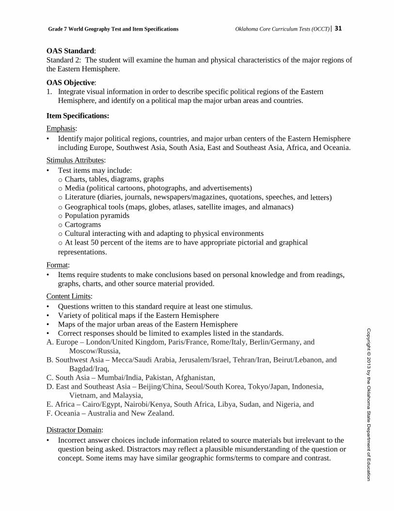
OAS Standard: Standard 2: The student will examine the human and physical characteristics of the major regions of the Eastern Hemisphere.
OAS Objective: 1. Integrate visual information in order to describe specific political regions of the Eastern
Hemisphere, and identify on a political map the major urban areas and countries. Item Specifications: Emphasis: • Identify major political regions, countries, and major urban centers of the Eastern Hemisphere
including Europe, Southwest Asia, South Asia, East and Southeast Asia, Africa, and Oceania. Stimulus Attributes: • Test items may include:
o Charts, tables, diagrams, graphs o Media (political cartoons, photographs, and advertisements) o Literature (diaries, journals, newspapers/magazines, quotations, speeches, and letters) o Geographical tools (maps, globes, atlases, satellite images, and almanacs) o Population pyramids o Cartograms o Cultural interacting with and adapting to physical environments o At least 50 percent of the items are to have appropriate pictorial and graphical representations.
Format: • Items require students to make conclusions based on personal knowledge and from readings,
graphs, charts, and other source material provided. Content Limits: • Questions written to this standard require at least one stimulus. • Variety of political maps if the Eastern Hemisphere • Maps of the major urban areas of the Eastern Hemisphere • Correct responses should be limited to examples listed in the standards. A. Europe – London/United Kingdom, Paris/France, Rome/Italy, Berlin/Germany, and
Moscow/Russia, B. Southwest Asia – Mecca/Saudi Arabia, Jerusalem/Israel, Tehran/Iran, Beirut/Lebanon, and
Bagdad/Iraq, C. South Asia – Mumbai/India, Pakistan, Afghanistan, D. East and Southeast Asia – Beijing/China, Seoul/South Korea, Tokyo/Japan, Indonesia,
Vietnam, and Malaysia, E. Africa – Cairo/Egypt, Nairobi/Kenya, South Africa, Libya, Sudan, and Nigeria, and F. Oceania – Australia and New Zealand.
Distractor Domain: • Incorrect answer choices include information related to source materials but irrelevant to the
question being asked. Distractors may reflect a plausible misunderstanding of the question or concept. Some items may have similar geographic forms/terms to compare and contrast.
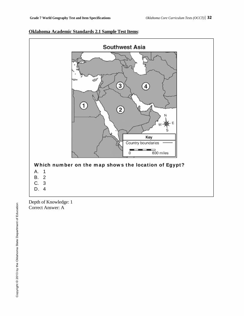
Grade 7 World Geography Test and Item Specifications Oklahoma Core Curriculum Tests (OCCT)| 32
Oklahoma Academic Standards 2.1 Sample Test Items:
Which number on the map shows the location of Egypt? A. 1 B. 2 C. 3 D. 4
Depth of Knowledge: 1 Correct Answer: A

Grade 7 World Geography Test and Item Specifications Oklahoma Core Curriculum Tests (OCCT)| 33
OAS Standard: Standard 2: The student will examine the human and physical characteristics of the major regions of the Eastern Hemisphere.
OAS Objective: 2. Integrate visual information in order to describe the characteristics and relative location of
physical and cultural regions of the Eastern Hemisphere. Item Specifications:
Emphasis: • Locate and describe the relative location of physical and cultural regions of the Eastern
Hemisphere. • Use geographic tools [maps, charts, graphs] to describe human and physical characteristics of
specific regions of the Eastern Hemisphere Stimulus Attributes: • Test items may include:
o Charts, tables, diagrams, graphs o Media (political cartoons, photographs, and advertisements) o Literature (diaries, journals, newspapers/magazines, quotations, speeches, and letters) o Geographical tools (maps, globes, atlases, satellite images, and almanacs) o Population pyramids o Cartograms o Cultural interacting with and adapting to physical environments o At least 50 percent of the items are to have appropriate pictorial and graphical representations.
Format: • Items require students to make conclusions based on personal knowledge and from readings,
graphs, charts, and other source material provided. Content Limits: • Questions written to this standard require at least one stimulus. • Maps, atlases, globes of including Europe, Southwest Asia, South Asia, East and Southeast
Asia, Africa, and Oceania • Correct responses should be limited to examples listed in the standards.
A. Physical Regions – 1) Sub-Saharan savannas and rainforests, 2) Pacific Ring of Fire, 3) Rhine-Danube industrial corridor, and 4) The Himalayan Mountain Range.
B. Cultural Regions – 1) The Sahel’s and Sahara’s nomadic peoples, 2) Jerusalem’s religious significance to Judaism, Christianity, and Islam, and 3) The cultural hearths of the Nile, Indus, Ganges, Hwang He River Valleys, and Mesopotamia.
Distractor Domain: • Incorrect answer choices include information related to source materials but irrelevant to the
question being asked. Distractors may reflect a plausible misunderstanding of the question or concept. Some items may have similar geographic forms/terms to compare and contrast.

Grade 7 World Geography Test and Item Specifications Oklahoma Core Curriculum Tests (OCCT)| 34
Oklahoma Academic Standards 2.2 Sample Test Items:
Courtesy of USGS.
Depth of Knowledge: 2 Correct Answer: D
A desert like this would most likely be found in A. Europe. B. Oceania. C. Southeast Asia. D. Southwest Asia.

Grade 7 World Geography Test and Item Specifications Oklahoma Core Curriculum Tests (OCCT)| 35
OAS Standard: Standard 2: The student will examine the human and physical characteristics of the major regions of the Eastern Hemisphere.
OAS Objective: 3. Explain and summarize how common physical or human characteristics can link as well as divide
regions. Item Specifications:
Emphasis: • Explain and summarize how common physical or human characteristics can link as well as
divide regions. Stimulus Attributes: • Test items may include:
o Charts, tables, diagrams, graphs o Media (political cartoons, photographs, and advertisements) o Literature (diaries, journals, newspapers/magazines, quotations, speeches, and letters) o Geographical tools (maps, globes, atlases, satellite images, and almanacs) o Population pyramids o Cartograms o Cultural interacting with and adapting to physical environments o At least 50 percent of the items are to have appropriate pictorial and graphical representations.
Format: • Items require students to make conclusions based on personal knowledge and from readings,
graphs, charts, and other source material provided. Content Limits: • Questions written to this standard require at least one stimulus. • Correct responses should be limited to examples listed in the standards. A. Extensive inland waterway systems of natural rivers and manmade canals that link European
trading centers, B. Ural Mountains that physically divide Europe from Asia, C. Sahara Desert that physically and culturally divides North Africa from Sub-Sahara Africa, D. Multiple languages, religion, and the legacy of the caste system in India that present barriers to
cultural unity, and E. Cultural differences resulting in civil war and genocide in Darfur and Rwanda. Distractor Domain: • Incorrect answer choices include information related to source materials but irrelevant to the
question being asked. Distractors may reflect a plausible misunderstanding of the question or concept. Some items may have similar geographic forms/terms to compare and contrast.

Grade 7 World Geography Test and Item Specifications Oklahoma Core Curriculum Tests (OCCT)| 36
Oklahoma Academic Standards 2.3 Sample Test Items:
Depth of Knowledge: 2 Correct Answer: B
According to the maps, what is the main reason for the low population in northern Africa?
A. a river floods regularly B. a desert is located there C. mountains make travel difficult D. agricultural lands limit construction
Grade 7 World Geography Test and Item Specifications Oklahoma Core Curriculum Tests (OCCT)| 37
OAS Standard: Standard 2: The student will examine the human and physical characteristics of the major regions of the Eastern Hemisphere.
OAS Objective: 4. Cite textual and visual evidence to analyze reasons for conflict and cooperation among groups,
societies, countries, and regions of the Eastern Hemisphere and the involvement of multinational organizations of the United Nations and the North Atlantic Treaty Organization.
Item Specifications:
Emphasis: • Analyze reasons for conflict and cooperation among groups, societies, countries and regions. • Explain the involvement of the United Nations and the North Atlantic Treaty Organization. Stimulus Attributes: • Test items may include:
o Charts, tables, diagrams, graphs o Media (political cartoons, photographs, and advertisements) o Literature (diaries, journals, newspapers/magazines, quotations, speeches, and letters) o Geographical tools (maps, globes, atlases, satellite images, and almanacs) o Population pyramids o Cartograms o Cultural interacting with and adapting to physical environments o At least 50 percent of the items are to have appropriate pictorial and graphical representations.
Format: • Items require students to make conclusions based on personal knowledge and from readings,
graphs, charts, and other source material provided. Content Limits: • Questions written to this standard require at least one stimulus. A. Multinational peace-keeping efforts to stabilize Arab-Israeli relations, B. Roots of disputes between India and Pakistan resulting in the threat of conventional war and
nuclear war, C. Impact of multiple ethnic groups on Nigerian political stability, D. Coordination of currency and free trade zones created by the European Union, E. Humanitarian relief efforts by the United Nations to address hunger in Africa, and F. The struggle for and achievement of civil liberties and economic opportunities in South Africa’s
post-apartheid era. Distractor Domain: • Incorrect answer choices include information related to source materials but irrelevant to the
question being asked. Distractors may reflect a plausible misunderstanding of the question or concept. Some items may have similar geographic forms/terms to compare and contrast.

Grade 7 World Geography Test and Item Specifications Oklahoma Core Curriculum Tests (OCCT)| 38
Oklahoma Academic Standards 2.4 Sample Test Items:
Which phrase best describes the basic cause of conflict between India and Pakistan?
A. military aggressions B. religious differences C. language differences D. economic disagreements
Depth of Knowledge: 1 Correct Answer: B

Grade 7 World Geography Test and Item Specifications Oklahoma Core Curriculum Tests (OCCT)| 39
Depth of Knowledge: 3 Correct Answer: C
Based on the information in the diagram, why is it important for international organizations like the United Nations and North Atlantic Treaty Organization to exist?
A. to force other nations to resolve issues peacefully B. to encourage the development of nuclear facilities C. to promote the benefits of global peace and cooperation D. to prevent other nations from obtaining modern weapons
Grade 7 World Geography Test and Item Specifications Oklahoma Core Curriculum Tests (OCCT)| 40
OAS Standard: Standard 2: The student will examine the human and physical characteristics of the major regions of the Eastern Hemisphere. OAS Objective: 5. Explain and summarize how and why regions change over time through physical and human
processes which operate to modify Earth’s surface. Item Specifications:
Emphasis: • Explain human and physical processes that transform the Earth’s surface.
Stimulus Attributes: • Test items may include:
o Charts, tables, diagrams, graphs o Media (political cartoons, photographs, and advertisements) o Literature (diaries, journals, newspapers/magazines, quotations, speeches, and letters) o Geographical tools (maps, globes, atlases, satellite images, and almanacs) o Population pyramids o Cartograms o Cultural interacting with and adapting to physical environments o At least 50 percent of the items are to have appropriate pictorial and graphical representations.
Format: • Items require students to make conclusions based on personal knowledge and from readings,
graphs, charts, and other source material provided.
Content Limits: A. Cultural diffusion brought about by North Africa’s location central to trade across multiple
continents, B. Impact of overgrazing and drought leading to desertification in the Sahel, C. Results of the Green Revolution in Central Asia, and D. Effects of abundant oil supplies in the Persian Gulf region.
Distractor Domain: • Incorrect answer choices include information related to source materials but irrelevant to the
question being asked. Distractors may reflect a plausible misunderstanding of the question or concept. Some items may have similar geographic forms/terms to compare and contrast.
Grade 7 World Geography Test and Item Specifications Oklahoma Core Curriculum Tests (OCCT)| 41
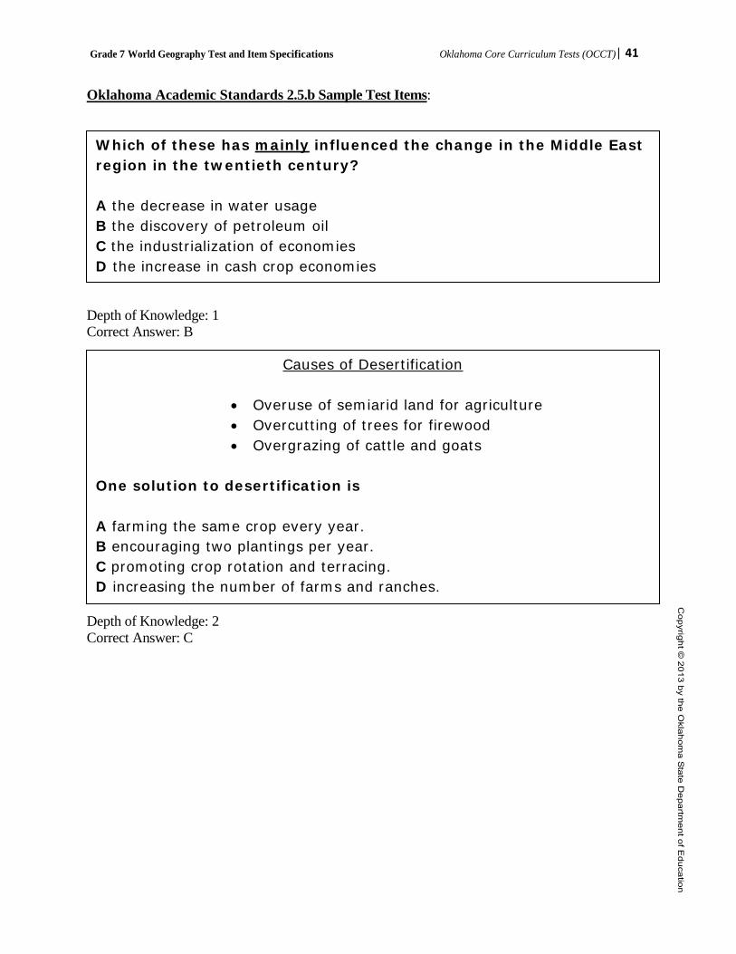
Oklahoma Academic Standards 2.5.b Sample Test Items:
Depth of Knowledge: 1 Correct Answer: B
Depth of Knowledge: 2 Correct Answer: C
Which of these has mainly influenced the change in the Middle East region in the twentieth century? A the decrease in water usage B the discovery of petroleum oil C the industrialization of economies D the increase in cash crop economies
Causes of Desertification
• Overuse of semiarid land for agriculture • Overcutting of trees for firewood • Overgrazing of cattle and goats
One solution to desertification is A farming the same crop every year. B encouraging two plantings per year. C promoting crop rotation and terracing. D increasing the number of farms and ranches.

Grade 7 World Geography Test and Item Specifications Oklahoma Core Curriculum Tests (OCCT)| 42
OAS Standard: Standard 3: The student will examine the interactions of physical systems that shape the patterns of Earth’s surface in the Eastern Hemisphere.
OAS Objective: 1. Integrate visual information to identify on a physical map and describe the major landforms and
bodies of water. Item Specifications:
Emphasis: • Identify major landforms and bodies of water. Stimulus Attributes: • Test items may include:
o Charts, tables, diagrams, graphs o Media (political cartoons, photographs, and advertisements) o Literature (diaries, journals, newspapers/magazines, quotations, speeches, and letters) o Geographical tools (maps, globes, atlases, satellite images, and almanacs) o Population pyramids o Cartograms o Cultural interacting with and adapting to physical environments o At least 50 percent of the items are to have appropriate pictorial and graphical representations.
Format: • Items require students to make conclusions based on personal knowledge and from readings,
graphs, charts, and other source material provided. Content Limits: • Questions written to this standard require at least one stimulus. A. Landforms: the Iberian, Scandinavian, and Indochina Peninsulas, the Urals, Pyrenees, Alps,
and Himalayan Mountain ranges; the Sahara, Kalahari, and Gobi Deserts, and the Great Rift Valley
B. Bodies of water: Danube, Volga, Nile, Congo, Niger, Tigris, Euphrates, Indus, Ganges, and Yangtze Rivers; Mediterranean, Arabian and North Seas; Persian Gulf; Bay of Bengal; Strait of Gibraltar; Atlantic, Arctic, Indian, Pacific, and the Southern Oceans
Distractor Domain: • Incorrect answer choices include information related to source materials but irrelevant to the
question being asked. Distractors may reflect a plausible misunderstanding of the question or concept. Some items may have similar geographic forms/terms to compare and contrast.

Grade 7 World Geography Test and Item Specifications Oklahoma Core Curriculum Tests (OCCT)| 43
Oklahoma Academic Standards 3.1 Sample Test Items:
Depth of Knowledge: 1 Correct Answer: B
What landform is shown by the map?
A. the Sahel B. the Sahara C. Gobi Desert D. Great Rift Valley

Grade 7 World Geography Test and Item Specifications Oklahoma Core Curriculum Tests (OCCT)| 44
OAS Standard: Standard 3: The student will examine the interactions of physical systems that shape the patterns of Earth’s surface in the Eastern Hemisphere.
OAS Objective: 2. Analyze from multiple perspectives the impact of natural disasters on human populations resulting
in forced migration, scarcity of consumer goods, and loss of employment. Item Specifications:
Emphasis: • Analyze the impact of natural disasters on human populations.
Stimulus Attributes: • Test items may include:
o Charts, tables, diagrams, graphs o Media (political cartoons, photographs, and advertisements) o Literature (diaries, journals, newspapers/magazines, quotations, speeches, and letters) o Geographical tools (maps, globes, atlases, satellite images, and almanacs) o Population pyramids o Cartograms o Cultural interacting with and adapting to physical environments o At least 50 percent of the items are to have appropriate pictorial and graphical representations.
Format: • Items require students to make conclusions based on personal knowledge and from readings,
graphs, charts, and other source material provided. Content Limits: A. The impact of plate tectonics resulting in earthquakes, tsunamis, and volcanic eruptions on
human and physical systems bordering the Pacific Ring of Fire, B. Frequent drought of northern Africa and Southwest Asia that creates stress on humans and
wildlife, C. The impact of monsoon patterns and typhoon activity on agriculture and loss of life in South
Asia, and D. Regular flooding of China’s rivers resulting in the accumulation of loess.
Distractor Domain: • Incorrect answer choices include information related to source materials but irrelevant to the
question being asked. Distractors may reflect a plausible misunderstanding of the question or concept. Some items may have similar geographic forms/terms to compare and contrast.

Grade 7 World Geography Test and Item Specifications Oklahoma Core Curriculum Tests (OCCT)| 45
Oklahoma Academic Standards 3.2 Sample Test Items:
Depth of Knowledge: 1 Correct Answer: A
Depth of Knowledge: 2 Correct Answer: B
People living in the red area need to prepare for A. earthquakes. B. droughts. C. floods. D. fires.
Which description can be an effect of a natural disaster? A. higher birth rates B. a scarcity of goods C. lower unemployment D. an increase in literacy
Grade 7 World Geography Test and Item Specifications Oklahoma Core Curriculum Tests (OCCT)| 46
OAS Standard: Standard 4: The student will analyze the world’s peoples and cultures in the context of the human systems in the Eastern Hemisphere.
OAS Objective: 1. Compare and contrast the common cultural traits including language, ethnic heritage, social
systems, religions, and traditions and how cultural diffusion impacts societies. Item Specifications:
Emphasis: • Describe the significance or impact of historical and cultural influences. • Compare/contrast movement of people (e.g., push/pull factors related to cultural diffusion),
common cultural traits of people in the Eastern Hemisphere and/or how cultural diffusion impacts societies.
• Identify common cultural traits belonging to various regions of the Eastern Hemisphere. • Draw conclusions about the development or changes to culture [or lack thereof] caused by
cultural diffusion. Stimulus Attributes: • Test items may include:
o Charts, tables, diagrams, graphs o Media (political cartoons, photographs, and advertisements) o Literature (diaries, journals, newspapers/magazines, quotations, speeches, and letters) o Geographical tools (maps, globes, atlases, satellite images, and almanacs) o Population pyramids o Cartograms o Cultural interacting with and adapting to physical environments o At least 50 percent of the items are to have appropriate pictorial and graphical representations.
Format: • Items require students to make conclusions based on personal knowledge and from readings,
graphs, charts, and other source material provided. Content Limits: • Colonization-significance v. impact or influence of colonization only, do not assess basic
identification of colonies • Culture: Language, ethnicity, religion • Social systems • Cultural diffusion Distractor Domain: • Incorrect answer choices include information related to source materials but irrelevant to the
question being asked. Distractors may reflect a plausible misunderstanding of the question or concept. Some items may have similar geographic forms/terms to compare and contrast.

Grade 7 World Geography Test and Item Specifications Oklahoma Core Curriculum Tests (OCCT)| 47
Oklahoma Academic Standards 4.1 Sample Test Items:
Depth of Knowledge: 2 Correct Answer: A
Which of these best completes the diagram? A. Islam B. Sikhism C. Hinduism D. Buddhism
Grade 7 World Geography Test and Item Specifications Oklahoma Core Curriculum Tests (OCCT)| 48
OAS Standard: Standard 4: The student will analyze the world’s peoples and cultures in the context of the human systems in the Eastern Hemisphere.
OAS Objective: 2. Describe the world’s major religions including Buddhism, Christianity, Daoism, Hinduism, Islam,
and Judaism including the geographic origins, major beliefs, and customs of the six major world religions and the significance of religion in contemporary societies.
Item Specifications: Emphasis: • Describe the world’s six major religions and their geographic origins, major beliefs and
customs • Describe the significance of religion in contemporary societies. Stimulus Attributes: • Test items may include:
o Charts, tables, diagrams, graphs o Media (political cartoons, photographs, and advertisements) o Literature (diaries, journals, newspapers/magazines, quotations, speeches, and letters) o Geographical tools (maps, globes, atlases, satellite images, and almanacs) o Population pyramids o Cartograms o Cultural interacting with and adapting to physical environments o At least 50 percent of the items are to have appropriate pictorial and graphical
representations.
Format: • Items require students to make conclusions based on personal knowledge and from readings,
graphs, charts, and other source material provided.
Content Limits: • Correct responses should be limited to examples listed in the standards. • The major beliefs, areas of origin, customs, and significance in society. Distractor Domain: • Incorrect answer choices include information related to source materials but irrelevant to the
question being asked. Distractors may reflect a plausible misunderstanding of the question or concept. Some items may have similar geographic forms/terms to compare and contrast.
Grade 7 World Geography Test and Item Specifications Oklahoma Core Curriculum Tests (OCCT)| 49
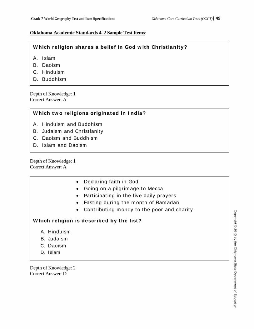
Oklahoma Academic Standards 4. 2 Sample Test Items:
Depth of Knowledge: 1 Correct Answer: A
Depth of Knowledge: 1 Correct Answer: A
Depth of Knowledge: 2 Correct Answer: D
Depth of Knowledge: 2 Correct Answer: D
Which religion shares a belief in God with Christianity?
A. Islam B. Daoism C. Hinduism D. Buddhism
Which two religions originated in India?
A. Hinduism and Buddhism B. Judaism and Christianity C. Daoism and Buddhism D. Islam and Daoism
• Declaring faith in God • Going on a pilgrimage to Mecca • Participating in the five daily prayers • Fasting during the month of Ramadan • Contributing money to the poor and charity
Which religion is described by the list?
A. Hinduism B. Judaism C. Daoism D. Islam

Grade 7 World Geography Test and Item Specifications Oklahoma Core Curriculum Tests (OCCT)| 50
OAS Standard: Standard 4: The student will analyze the world’s peoples and cultures in the context of the human systems in the Eastern Hemisphere.
OAS Objective: 3. Integrate visual information to analyze data used by geographers to measure the human
characteristics used to define developed versus developing countries including literacy rates, life expectancy, infant mortality rate, Gross National Product (GNP), and per capita income.
Item Specifications: Emphasis: • Analyze data from various types of visual information to identify and determine the
differences between developed and developing nations. Stimulus Attributes: Test items may include:
o Charts, tables, diagrams, graphs o Media (political cartoons, photographs, and advertisements) o Literature (diaries, journals, newspapers/magazines, quotations, speeches, and letters) o Geographical tools (maps, globes, atlases, satellite images, and almanacs) o Population pyramids o Cartograms o Cultural interacting with and adapting to physical environments o At least 50 percent of the items are to have appropriate pictorial and graphical representations.
Format: • Items require students to make conclusions based on personal knowledge and from readings,
graphs, charts, and other source material provided. Content Limits: • This item requires multiple stimuli. • Literacy rates • Life expectancy • Infant Mortality rate • Gross National Product (GNP) • Per Capita Income • Definition and characteristics of developing and developed nations Distractor Domain: • Incorrect answer choices include information related to source materials but irrelevant to the
question being asked. Distractors may reflect a plausible misunderstanding of the question or concept. Some items may have similar geographic forms/terms to compare and contrast.

Grade 7 World Geography Test and Item Specifications Oklahoma Core Curriculum Tests (OCCT)| 51
Oklahoma Academic Standards 4.3 Sample Test Items:
objective
Depth of Knowledge: 1 Correct Answer: A
Depth of Knowledge: 2 Correct Answer: C
What is one characteristic of a developing nation?
A. low literacy rate B. high employment C. low infant mortality rate D. high gross national product
Based on the table, which country has the lowest level of development? A. Angola B. Germany C. Indonesia D. Qatar

Grade 7 World Geography Test and Item Specifications Oklahoma Core Curriculum Tests (OCCT)| 52
OAS Standard: Standard 4: The student will analyze the world’s peoples and cultures in the context of the human systems in the Eastern Hemisphere.
OAS Objective: 4. Compare and contrast the market and command economic systems and how governments affect
economic activities in such systems. Item Specifications: Emphasis: • Compare and contrast market and command economic systems and how governments affect
economic activities. Stimulus Attributes: • Test items may include:
o Charts, tables, diagrams, graphs o Media (political cartoons, photographs, and advertisements) o Literature (diaries, journals, newspapers/magazines, quotations, speeches, and letters) o Geographical tools (maps, globes, atlases, satellite images, and almanacs) o Population pyramids o Cartograms o Cultural interacting with and adapting to physical environments o At least 50 percent of the items are to have appropriate pictorial and graphical representations.
Format: • Items require students to make conclusions based on personal knowledge and from readings,
graphs, charts, and other source material provided. Content Limits: A. Economic reforms in China that are moving China from a command system toward a market
system, B. The economic advantages and disadvantages of Sweden’s mixed market system, C. The economic prosperity generated by Japan’s market system, and D. The economic development limitations of North Korea’s command economic system. Distractor Domain: • Incorrect answer choices include information related to source materials but irrelevant to the
question being asked. Distractors may reflect a plausible misunderstanding of the question or concept. Some items may have similar geographic forms/terms to compare and contrast.
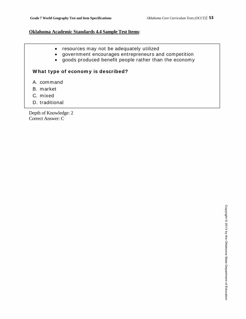
Grade 7 World Geography Test and Item Specifications Oklahoma Core Curriculum Tests (OCCT)| 53
Oklahoma Academic Standards 4.4 Sample Test Items:
• resources may not be adequately utilized • government encourages entrepreneurs and competition • goods produced benefit people rather than the economy
What type of economy is described?
A. command B. market C. mixed D. traditional
Depth of Knowledge: 2 Correct Answer: C

Grade 7 World Geography Test and Item Specifications Oklahoma Core Curriculum Tests (OCCT)| 54
OAS Standard:
Standard 4: The student will analyze the world’s peoples and cultures in the context of the human systems in the Eastern Hemisphere.
OAS Objective: 5. Compare and contrast the major political systems of representative governments (democracy,
republic, and constitutional monarchy) and authoritarian systems (dictatorship and absolute monarchy) including the role of the citizen in the selection of government officials, lawmaking, and the liberties guaranteed under different forms of government.
Item Specifications: Emphasis: • Compare and contrast guaranteed liberties and methods of selecting government officials in
major political systems. Stimulus Attributes: • Test items may include:
o Charts, tables, diagrams, graphs o Media (political cartoons, photographs, and advertisements) o Literature (diaries, journals, newspapers/magazines, quotations, speeches, and letters) o Geographical tools (maps, globes, atlases, satellite images, and almanacs) o Population pyramids o Cartograms o Cultural interacting with and adapting to physical environments o At least 50 percent of the items are to have appropriate pictorial and graphical representations.
Format: • Items require students to make conclusions based on personal knowledge and from readings,
graphs, charts, and other source material provided. Content Limits: • Items not specific to information below can be aligned to the objective. • Correct responses should be limited to examples listed in the standards. • Focus of questions should be on nations using government systems, not on identification of
what government system each country uses. • Limit countries to those listed in grade 7 curriculum standards. A. The symbolic role of the British crown in comparison to the absolute authority of the monarchy
of Saudi Arabia. B. The transformation of the former Soviet Union from an authoritarian system to the limited
representative democracy of Russia.
Distractor Domain: • Incorrect answer choices include information related to source materials but irrelevant to the
question being asked. Distractors may reflect a plausible misunderstanding of the question or concept. Some items may have similar geographic forms/terms to compare and contrast.
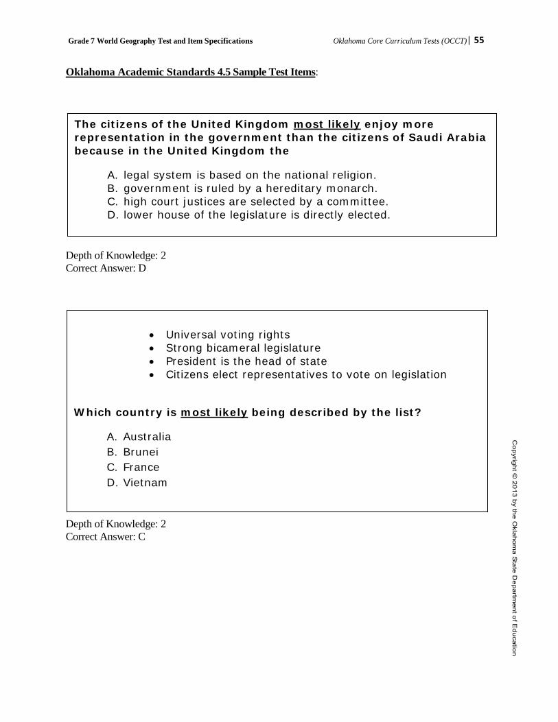
Grade 7 World Geography Test and Item Specifications Oklahoma Core Curriculum Tests (OCCT)| 55
Oklahoma Academic Standards 4.5 Sample Test Items:
Depth of Knowledge: 2 Correct Answer: D
Depth of Knowledge: 2 Correct Answer: C
• Universal voting rights • Strong bicameral legislature • President is the head of state • Citizens elect representatives to vote on legislation
Which country is most likely being described by the list?
A. Australia B. Brunei C. France D. Vietnam
The citizens of the United Kingdom most likely enjoy more representation in the government than the citizens of Saudi Arabia because in the United Kingdom the
A. legal system is based on the national religion. B. government is ruled by a hereditary monarch. C. high court justices are selected by a committee. D. lower house of the legislature is directly elected.
Grade 7 World Geography Test and Item Specifications Oklahoma Core Curriculum Tests (OCCT)| 56
OAS Standard: Standard 4: The student will analyze the world’s peoples and cultures in the context of the human systems in the Eastern Hemisphere.
OAS Objective: 6. Integrate visual information to explain patterns of global economic interdependence and world trade focusing on the concepts of imports and exports, supply and demand, Gross National Product (GNP), and balance of trade. Item Specifications: Emphasis: • Explain patterns of global economic interdependence and world trade. Stimulus Attributes: • Test items may include:
o Charts, tables, diagrams, graphs o Media (political cartoons, photographs, and advertisements) o Literature (diaries, journals, newspapers/magazines, quotations, speeches, and letters) o Geographical tools (maps, globes, atlases, satellite images, and almanacs) o Population pyramids o Cartograms o Cultural interacting with and adapting to physical environments o At least 50 percent of the items are to have appropriate pictorial and graphical representations.
Format: • Items require students to make conclusions based on personal knowledge and from readings,
graphs, charts, and other source material provided. Content Limits: • Questions written to this standard require at least one stimulus. A. The European Union’s single currency and open single market that link economies and
governments, B. The relative isolation of Japan and the United Kingdom that require extensive trade patterns for
natural resources and markets, C. Outsourcing of technological and manufacturing jobs to developing regions of Asia, and D. Control over production and supply of global oil reserves as exercised by the Oil Producing and
Exporting Countries (OPEC).
Distractor Domain: • Incorrect answer choices include information related to source materials but irrelevant to the
question being asked. Distractors may reflect a plausible misunderstanding of the question or concept. Some items may have similar geographic forms/terms to compare and contrast.
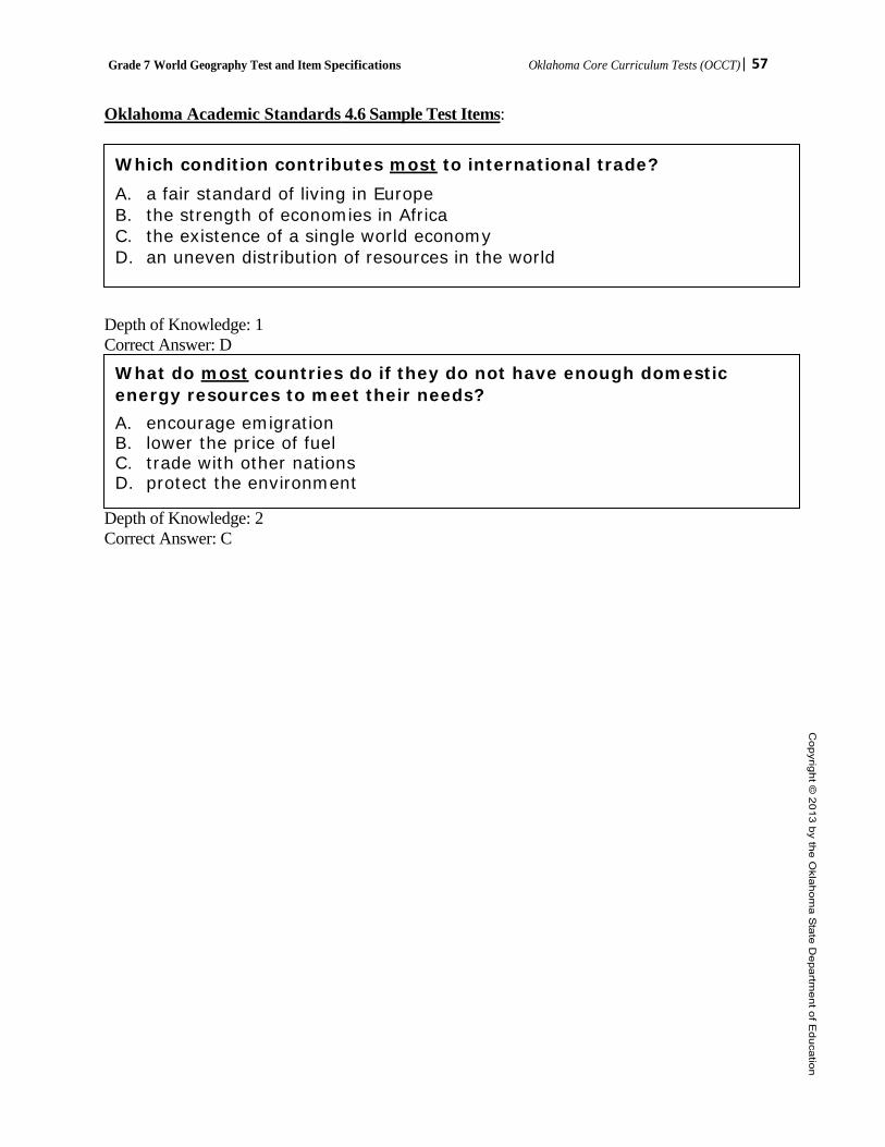
Grade 7 World Geography Test and Item Specifications Oklahoma Core Curriculum Tests (OCCT)| 57
Oklahoma Academic Standards 4.6 Sample Test Items:
Depth of Knowledge: 1 Correct Answer: D Depth of Knowledge: 2 Correct Answer: C
Which condition contributes most to international trade? A. a fair standard of living in Europe B. the strength of economies in Africa C. the existence of a single world economy D. an uneven distribution of resources in the world
What do most countries do if they do not have enough domestic energy resources to meet their needs? A. encourage emigration B. lower the price of fuel C. trade with other nations D. protect the environment
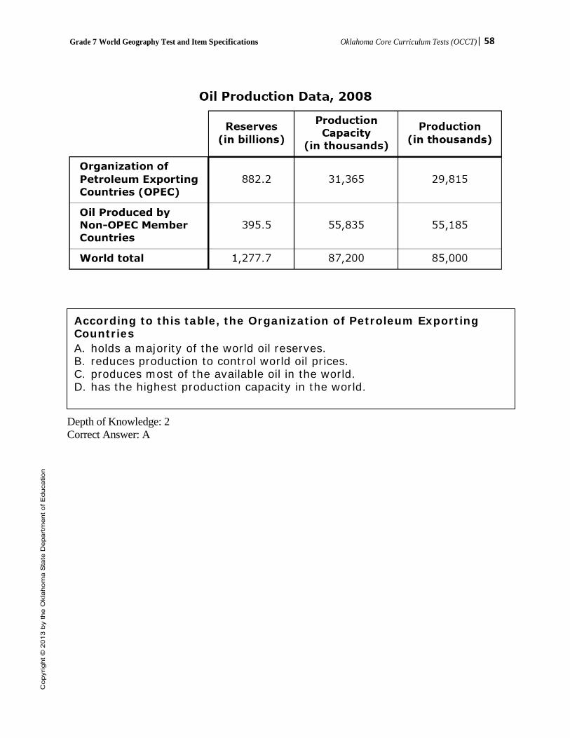
Grade 7 World Geography Test and Item Specifications Oklahoma Core Curriculum Tests (OCCT)| 58
World Crude Oil Reserves, Production Capacity, and Production in Barrels, 2008
Depth of Knowledge: 2 Correct Answer: A
According to this table, the Organization of Petroleum Exporting Countries A. holds a majority of the world oil reserves. B. reduces production to control world oil prices. C. produces most of the available oil in the world. D. has the highest production capacity in the world.

Grade 7 World Geography Test and Item Specifications Oklahoma Core Curriculum Tests (OCCT)| 59
OAS Standard: Standard 4: The student will analyze the world’s peoples and cultures in the context of the human systems in the Eastern Hemisphere.
OAS Objective: 7. Evaluate and summarize the impact of geography on population location, growth, change and
density and on the availability of resources, settlement patterns, and migration. Item Specifications:
Emphasis: • Describe/compare/evaluate how geography affects population • Describe/compare/evaluate how geography and the availability of resources affects the
movement of people Stimulus Attributes: • Test items may include:
o Charts, tables, diagrams, graphs o Media (political cartoons, photographs, and advertisements) o Literature (diaries, journals, newspapers/magazines, quotations, speeches, and letters) o Geographical tools (maps, globes, atlases, satellite images, and almanacs) o Population pyramids o Cartograms o Cultural interacting with and adapting to physical environments o At least 50 percent of the items are to have appropriate pictorial and graphical representations.
Format: • Items require students to make conclusions based on personal knowledge and from readings,
graphs, charts, and other source material provided. Content Limits: • Questions written to this standard require at least one stimulus. A. Impact of push and pull factors on the rural migration to overcrowded urban centers in India, B. Challenges of under-population on the labor market in developed nations of Europe, C. Changing face of European cultures as a result of recent patterns of immigration, and D. Impact of China’s one-child policy on population growth and decline.
Distractor Domain: • Incorrect answer choices include information related to source materials but irrelevant to the
question being asked. Distractors may reflect a plausible misunderstanding of the question or concept. Some items may have similar geographic forms/terms to compare and contrast.
Grade 7 World Geography Test and Item Specifications Oklahoma Core Curriculum Tests (OCCT)| 60
Oklahoma Academic Standards 4.7 Sample Test Items:
Depth of Knowledge: 1 Correct Answer: D
The Nile River Valley in Egypt is densely populated because A. many of ancient Egypt’s monuments are near the Nile. B. the Nile is Egypt’s principal defense against invaders. C. fish from the Nile is the main food source in Egypt. D. the Nile is the major source of water in Egypt.
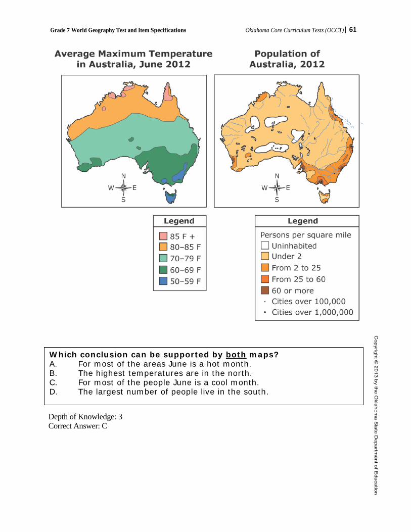
Grade 7 World Geography Test and Item Specifications Oklahoma Core Curriculum Tests (OCCT)| 61
Depth of Knowledge: 3 Correct Answer: C
Which conclusion can be supported by both maps? A. For most of the areas June is a hot month. B. The highest temperatures are in the north. C. For most of the people June is a cool month. D. The largest number of people live in the south.
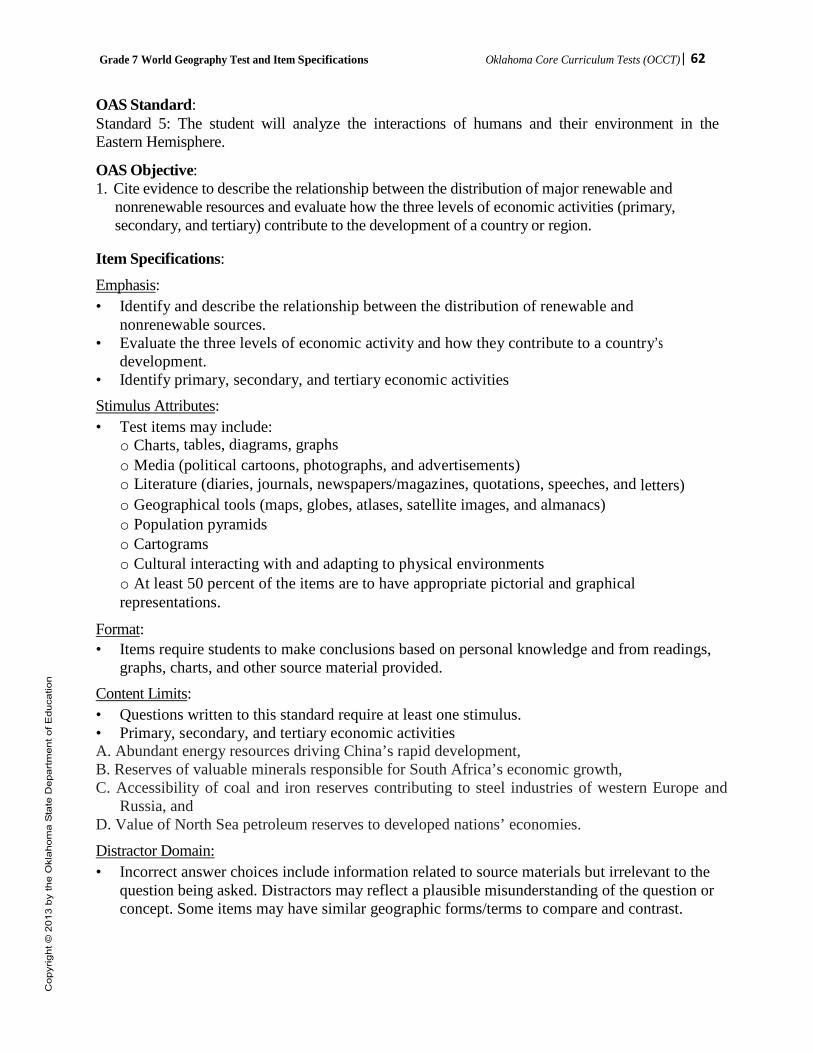
Grade 7 World Geography Test and Item Specifications Oklahoma Core Curriculum Tests (OCCT)| 62
OAS Standard: Standard 5: The student will analyze the interactions of humans and their environment in the Eastern Hemisphere.
OAS Objective: 1. Cite evidence to describe the relationship between the distribution of major renewable and
nonrenewable resources and evaluate how the three levels of economic activities (primary, secondary, and tertiary) contribute to the development of a country or region.
Item Specifications:
Emphasis: • Identify and describe the relationship between the distribution of renewable and
nonrenewable sources. • Evaluate the three levels of economic activity and how they contribute to a country’s
development. • Identify primary, secondary, and tertiary economic activities Stimulus Attributes: • Test items may include:
o Charts, tables, diagrams, graphs o Media (political cartoons, photographs, and advertisements) o Literature (diaries, journals, newspapers/magazines, quotations, speeches, and letters) o Geographical tools (maps, globes, atlases, satellite images, and almanacs) o Population pyramids o Cartograms o Cultural interacting with and adapting to physical environments o At least 50 percent of the items are to have appropriate pictorial and graphical representations.
Format: • Items require students to make conclusions based on personal knowledge and from readings,
graphs, charts, and other source material provided. Content Limits: • Questions written to this standard require at least one stimulus. • Primary, secondary, and tertiary economic activities A. Abundant energy resources driving China’s rapid development, B. Reserves of valuable minerals responsible for South Africa’s economic growth, C. Accessibility of coal and iron reserves contributing to steel industries of western Europe and
Russia, and D. Value of North Sea petroleum reserves to developed nations’ economies.
Distractor Domain: • Incorrect answer choices include information related to source materials but irrelevant to the
question being asked. Distractors may reflect a plausible misunderstanding of the question or concept. Some items may have similar geographic forms/terms to compare and contrast.
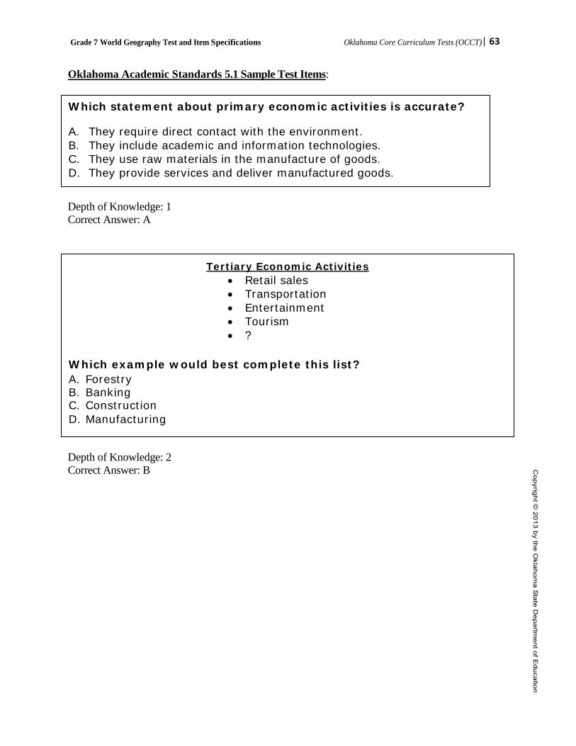
Grade 7 World Geography Test and Item Specifications Oklahoma Core Curriculum Tests (OCCT)| 63
Oklahoma Academic Standards 5.1 Sample Test Items: Whi Depth of Knowledge: 1 Correct Answer: A Depth of Knowledge: 2 Correct Answer: B
Tertiary Economic Activities • Retail sales • Transportation • Entertainment • Tourism • ?
Which example would best complete this list? A. Forestry B. Banking C. Construction D. Manufacturing
Which statement about primary economic activities is accurate?
A. They require direct contact with the environment. B. They include academic and information technologies. C. They use raw materials in the manufacture of goods. D. They provide services and deliver manufactured goods.

Grade 7 World Geography Test and Item Specifications Oklahoma Core Curriculum Tests (OCCT)| 64
OAS Standard: Standard 5: The student will analyze the interactions of humans and their environment in the Eastern Hemisphere. OAS Objective: 2. Evaluate the effects of human modification of and adaptation to the natural environment. Item Specifications: Emphasis: • Explain and evaluate human population growth—cause and effect. • Understand and analyze human interaction with and adaptation to physical environments. Stimulus Attributes: • Test items may include:
o Charts, tables, diagrams, graphs o Media (political cartoons, photographs, and advertisements) o Literature (diaries, journals, newspapers/magazines, quotations, speeches, and letters) o Geographical tools (maps, globes, atlases, satellite images, and almanacs) o Population pyramids o Cartograms o Cultural interacting with and adapting to physical environments o At least 50 percent of the items are to have appropriate pictorial and graphical representations.
Format: • Items require students to make conclusions based on personal knowledge and from readings,
graphs, charts, and other source material provided. Content Limits: • Questions written to this standard require at least one stimulus. • Desertification, pollution, deforestation, recycling, irrigation A. Deforestation of Indonesia’s rainforests, B. Creation of living space through the drainage of seawater and the system of dikes in the
Netherlands, (include use and development of polders) C. Transformation of arid lands of the Arabian Peninsula through introduction of western
irrigation methods, D. Use of terrace farming and double-cropping as solutions to food needs of East Asia, and E. Benefits and dangers of nuclear power generation as exemplified by the environmental disaster
at Chernobyl. Distractor Domain: • Incorrect answer choices include information related to source materials but irrelevant to the
question being asked. Distractors may reflect a plausible misunderstanding of the question or concept. Some items may have similar geographic forms/terms to compare and contrast.

Grade 7 World Geography Test and Item Specifications Oklahoma Core Curriculum Tests (OCCT)| 65
Oklahoma Academic Standards 5.2.b Sample Test Items:
Depth of Knowledge: 2 Correct Answer: D
Depth of Knowledge: 2 Correct Answer: A
• About 27% of the land lies below sea level • About 60% of the population lives on reclaimed land • Uses windmills to help drain water from the land
Which country is described by the list? A. England B. France C. Italy D. Netherlands
The areas shaded in black on the maps are most threatened by A. floods. B. drought. C. earthquakes. D. desertification.

Grade 7 World Geography Test and Item Specifications Oklahoma Core Curriculum Tests (OCCT)| 66
OAS Standard: Standard 5: The student will analyze the interactions of humans and their environment in the Eastern Hemisphere.
OAS Objective:
3. Integrate visual information to analyze regional problems and policies having spatial dimensions in the Eastern Hemisphere.
Item Specifications: Emphasis: • Analyze visual information to explain regional problems and policies having spatial
dimensions. Stimulus Attributes: • Test items may include:
o Charts, tables, diagrams, graphs o Media (political cartoons, photographs, and advertisements) o Literature (diaries, journals, newspapers/magazines, quotations, speeches, and letters) o Geographical tools (maps, globes, atlases, satellite images, and almanacs) o Population pyramids o Cartograms o Cultural interacting with and adapting to physical environments o At least 50 percent of the items are to have appropriate pictorial and graphical representations.
Format: • Items require students to make conclusions based on personal knowledge and from readings,
graphs, charts, and other source material provided. Content Limits: • Questions written to this standard require at least one stimulus. A. Management of the Aral Sea’s water resources, B. Impact of economic development on Russia’s Arctic regions, and C. Transformation of the environment and population centers caused by the construction of the
Three Gorges Dam in China. Distractor Domain: • Incorrect answer choices include information related to source materials but irrelevant to the
question being asked. Distractors may reflect a plausible misunderstanding of the question or concept. Some items may have similar geographic forms/terms to compare and contrast.
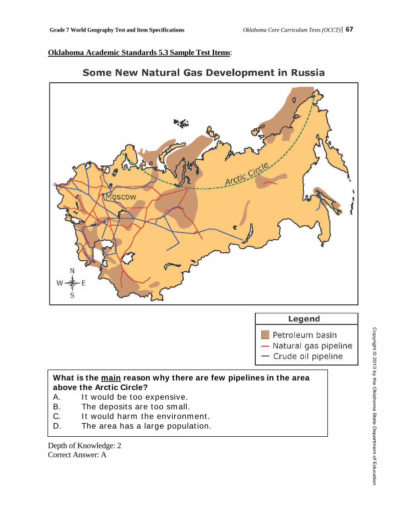
Grade 7 World Geography Test and Item Specifications Oklahoma Core Curriculum Tests (OCCT)| 67
Oklahoma Academic Standards 5.3 Sample Test Items:
Depth of Knowledge: 2 Correct Answer: A
What is the main reason why there are few pipelines in the area above the Arctic Circle? A. It would be too expensive. B. The deposits are too small. C. It would harm the environment. D. The area has a large population.