Embed Size (px)
Citation preview

Technical University Braunschweig, GermanyInstitute for Geodesy and Photogrammetry
Potential of Geodetic Techniques for Construction ProcessesWolfgang Niemeier
On the Potential of Geodetic Techniques
for the Navigation ofConstruction Processes
by
Wolfgang NiemeierTechnical University Braunschweig
Germany
Technical University Braunschweig, GermanyInstitute for Geodesy and Photogrammetry
Potential of Geodetic Techniques for Construction ProcessesWolfgang Niemeier
Agenda
Construction and Surveying
Typical Applications
Requirements for Geodetic Participation in Construction Process
Modern Instrumental Developments
Data processing and Communication
Construction Process as Dynamic System

Technical University Braunschweig, GermanyInstitute for Geodesy and Photogrammetry
Potential of Geodetic Techniques for Construction ProcessesWolfgang Niemeier
Construction and Surveying
Phases of construction Surveying delivers :• Idea/ Feasibility <= Maps, GIS• General Planning <= Detailed GIS• Design <= Coordinate references• Real Construction <= Setting out, quality control• Utilisation Phase <= As-built documentation
Reconstructions + Monitoring• Demolition
Situation now : Services from Surveying
Ideal situation : Real Integration

Technical University Braunschweig, GermanyInstitute for Geodesy and Photogrammetry
Potential of Geodetic Techniques for Construction ProcessesWolfgang Niemeier
Real Integration of Surveying in Construction Process
Design phase 3D-coordinates
(virtual model)
Real construction All geometrical aspects
phase by surveying engineering
=>
<=>
<=>

Technical University Braunschweig, GermanyInstitute for Geodesy and Photogrammetry
Potential of Geodetic Techniques for Construction ProcessesWolfgang Niemeier
Typical ApplicationsTunneling : Steering of Tunnel Drilling Maschines (TDM)
with total stations and electronic laser systems
Roads : Steering of pavement machines with total stations
Earth work : Steering of dozers and graders by rotating levels and/or GPS
Structural engineering : Basic setting out+ checking of pre-fabricated concrete elements+ quality control for setting out
Bridges : Basic setting out+ monitoring the behaviour of the structure during
critical phases of the construction

Technical University Braunschweig, GermanyInstitute for Geodesy and Photogrammetry
Potential of Geodetic Techniques for Construction ProcessesWolfgang Niemeier
Requirements for stronger integration of surveying in construction processes :
Measuring techniques to determine geometry of arbitrary forms and structures without targets
Processing techniques to compute geometry and derivation from design model in real time
Communication and data structure for interaction with information systems used in construction

Technical University Braunschweig, GermanyInstitute for Geodesy and Photogrammetry
Potential of Geodetic Techniques for Construction ProcessesWolfgang Niemeier
Modern Measuring Techniques Requirements :- Geometry of arbitrary forms and structures - Without targets- Flexible : Fast and from arbitrary position- Sufficient accuracy
Instruments :- Laserscanner- Lasertracker- GPS (?)- Automatic Total Stations (?)

Technical University Braunschweig, GermanyInstitute for Geodesy and Photogrammetry
Potential of Geodetic Techniques for Construction ProcessesWolfgang Niemeier
Applications : „Continuous in Space“
Scanning Systems : Remote capture of the geometry of a surface by a raster of predefined points without specific targets
Tracking Systems : Follow up a specific reflector which is „in touch“ withthe surface of an object

Technical University Braunschweig, GermanyInstitute for Geodesy and Photogrammetry
Potential of Geodetic Techniques for Construction ProcessesWolfgang Niemeier
Applications „Continuous in Time“ (Tracking Systems)
Lasertracker
Leica LTD500
Automated Total Stations
FARO

Technical University Braunschweig, GermanyInstitute for Geodesy and Photogrammetry
Potential of Geodetic Techniques for Construction ProcessesWolfgang Niemeier
Different LaserscannersLeicaCyrax 2500
CallidusCallidus Precision Systems
Imager 5003Zoller + Fröhlich
(Schwarz 2003)
Technical University Braunschweig, GermanyInstitute for Geodesy and Photogrammetry
Potential of Geodetic Techniques for Construction ProcessesWolfgang Niemeier
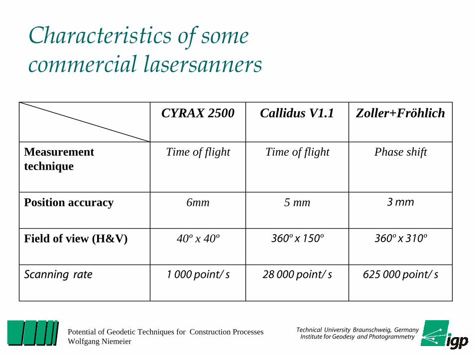
Characteristics of some commercial lasersanners
CYRAX 2500 Callidus V1.1 Zoller+Fröhlich
Measurement technique
Time of flight Time of flight Phase shift
Position accuracy 6mm 5 mm 3 mm
Field of view (H&V) 40º x 40º 360º x 150º 360º x 310º
Scanning rate 1 000 point/ s 28 000 point/ s 625 000 point/ s

Technical University Braunschweig, GermanyInstitute for Geodesy and Photogrammetry
Potential of Geodetic Techniques for Construction ProcessesWolfgang Niemeier
Potential of 3D-Laserscanning
To determine
• arbitrary objects,
• 3-dimensional,
• with correct scale,
• in a few minutes,
• complete
Back view of 2 form elements from PERI
„Cloud of Points“ with about 1 Million 3D-points.The colors indicate remission values

Technical University Braunschweig, GermanyInstitute for Geodesy and Photogrammetry
Potential of Geodetic Techniques for Construction ProcessesWolfgang Niemeier
Application of 3D-Laserscanning to control a form
To control :- position in reference
coordinate system- angles between
different forms- flatness within form
Requirements :- without interrupting the
construction process- partial visibility has to
be sufficient
ti
ti+1
Technical University Braunschweig, GermanyInstitute for Geodesy and Photogrammetry
Potential of Geodetic Techniques for Construction ProcessesWolfgang Niemeier
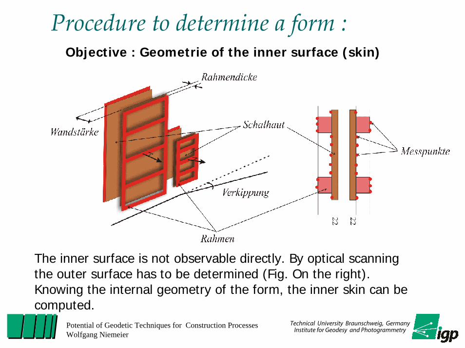
Procedure to determine a form :Objective : Geometrie of the inner surface (skin)
The inner surface is not observable directly. By optical scanningthe outer surface has to be determined (Fig. On the right). Knowing the internal geometry of the form, the inner skin can becomputed.

Tilting of the 2 form elements :
1. Tilt in vertical direction(cross section)
2. Tilt in horizontal direction(ground plan)
Results
Technical University Braunschweig, GermanyInstitute for Geodesy and Photogrammetry
Potential of Geodetic Techniques for Construction ProcessesWolfgang Niemeier
• Internal flatness of elements• Absolute position of form elements• …
Further aspects :

Technical University Braunschweig, GermanyInstitute for Geodesy and Photogrammetry
Potential of Geodetic Techniques for Construction ProcessesWolfgang Niemeier
Real Time Processing „Real Time“ : Time intervall until this information
is required for next step
=> In construction : minutes, hours, days
Geodetic processing techniques have to be optimized to deliver in real time :
- geometry of arbitrary structures (not of a few points)
- derivation from design model (including an evaluation of the significance of the differences)
=> Intelligent, automated processing algorithms
Technical University Braunschweig, GermanyInstitute for Geodesy and Photogrammetry
Potential of Geodetic Techniques for Construction ProcessesWolfgang Niemeier
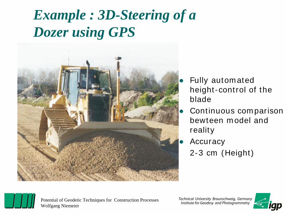
Example : 3D-Steering of a Dozer using GPS
Fully automated height-control of the bladeContinuous comparison bewteen model and realityAccuracy2-3 cm (Height)

Different Measuring Systems and Applications
(Retcher, 2002)
Technical University Braunschweig, GermanyInstitute for Geodesy and Photogrammetry
Potential of Geodetic Techniques for Construction ProcessesWolfgang Niemeier

Technical University Braunschweig, GermanyInstitute for Geodesy and Photogrammetry
Potential of Geodetic Techniques for Construction ProcessesWolfgang Niemeier
Advanced Compaction Control System (ACCS)
Data management
Visualisation
Dokumentationand analyses
EGM32-SoftwareSensoren

Technical University Braunschweig, GermanyInstitute for Geodesy and Photogrammetry
Potential of Geodetic Techniques for Construction ProcessesWolfgang Niemeier
Project ObjectivesVolume Accounting
– yearly, monthly and daily Accounting
Control of the Emplacement Progress– Determination of the backfilled Dump Volume– Indication of the residual Remaining Volume
Optimization of the Emplacement Technologie – Availability of Control Information
Increase of the efficiency
Development of a Measuring System for continuous recording of
Surface and Surface Changes

Technical University Braunschweig, GermanyInstitute for Geodesy and Photogrammetry
Potential of Geodetic Techniques for Construction ProcessesWolfgang Niemeier
Geometrical derivation of surface changes
hK
ompak torhöhe
H = kons tant
h
h = Verdichtung
Deponiekörper
Abfallschicht
∆h = Compaction
Landfill Body
• Determination of the Compactor Position with Real-Time-Kinematik GPS
• Determination of the Compaction in case of High-Differences of individual Crossings

Technical University Braunschweig, GermanyInstitute for Geodesy and Photogrammetry
Potential of Geodetic Techniques for Construction ProcessesWolfgang Niemeier
Systemconfiguration
• GPS-Antenna+ Radio Link
• Inclination Sensor - NMSK 3-30D (Glötzl)- Accuracy: 0,01°- Permissible InclinationField 45°
• Azimuth Sensor - HMR 3000 (Honeywell)
- Accuracy: 0,5°
• GPS-System- MC 1000 (Leica)- Accuracy 1-2 cm (3D-Position)

Technical University Braunschweig, GermanyInstitute for Geodesy and Photogrammetry
Potential of Geodetic Techniques for Construction ProcessesWolfgang Niemeier
GPS
Earth-magnetic-
sensorA°
αβ
∆X∆Y∆Z
Inclination-sensor
Data processing
RTL
HTL
HTNN
RLHL
HNN
InformationModell of
Dump
Control information
Update
Volume
Crossing
z
y
x
D
h(p)
p
DEM
Information
Management of measuring data
Data logging

Technical University Braunschweig, GermanyInstitute for Geodesy and Photogrammetry
Potential of Geodetic Techniques for Construction ProcessesWolfgang Niemeier
Determination of Surfaces
z
y
xhf
grid
compression surface
IGP 2000 Thomsen / Vogel
1m
surface approximation(here 1x1m)
estimation of mean height of every grid element compression surfaces representing the effect of the compactor

Technical University Braunschweig, GermanyInstitute for Geodesy and Photogrammetry
Potential of Geodetic Techniques for Construction ProcessesWolfgang Niemeier
Steering Information for Driver
Functions
Number of crossings
Actual Position of Compactor
Number of crossings
Definition of new crossingsStorage of a digitalelevation modelInterface toinformation system
Navigation
Status of achieved density(compression)

Technical University Braunschweig, GermanyInstitute for Geodesy and Photogrammetry
Potential of Geodetic Techniques for Construction ProcessesWolfgang Niemeier
Communication LinksCommon data base and data structure for design model and results of surveying => Information system for each construction
Intelligent and continuous communication links between structural and surveying engineer
Presentation of results in attractive graphical form :no lists with coordinates or displacements, no raw drawings !!

Technical University Braunschweig, GermanyInstitute for Geodesy and Photogrammetry
Potential of Geodetic Techniques for Construction ProcessesWolfgang Niemeier
Existing Standard for Presentation of Geometry Responsible :International Alliance for Interoperability (IAI)www.iai-international.orgwww.iai-ev.de
Industry Foundation Classes IFC• Standard for Exchange of Information of Building
• Dokumented in XML and Express

Technical University Braunschweig, GermanyInstitute for Geodesy and Photogrammetry
Potential of Geodetic Techniques for Construction ProcessesWolfgang Niemeier
IFC-Standard
Uniformity
Parametrisation in all dimensions
Topology
n : m – Relations between geometry and topology
Axis in time
Stochastic information
Storage of observations
Ability to use in real-time

Technical University Braunschweig, GermanyInstitute for Geodesy and Photogrammetry
Potential of Geodetic Techniques for Construction ProcessesWolfgang Niemeier
Geometry and Topology
LayerMesh 1 Mesh 2
MeshesLayer carry(1,*) (1,1)
1 : N
Technical University Braunschweig, GermanyInstitute for Geodesy and Photogrammetry
Potential of Geodetic Techniques for Construction ProcessesWolfgang Niemeier
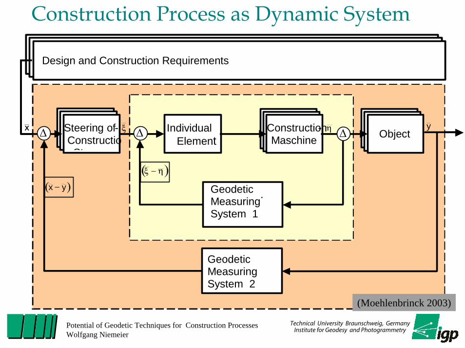
Construction Process as Dynamic System
Herstellungs - und Fertigungsvorgaben
Kinemat . Ing.-Geodät.
Messsysteme 1
Kinemat . Ing.-Geodät.
Messsysteme 2
Fertigungs - Steuerung ∆
( )yx −
( )ηξ −
yx ξ ηMaschinen-Regler
∆ Fertigungs-Maschine Objekt∆
Design and Construction Requirements
Geodetic Measuring System 1
.
Geodetic Measuring System 2
Steering of - ConstructioSt
∆
( )yx −
( )ηξ −
yx ξ η IndividualElement
∆ Construction-Maschine Object∆
(Moehlenbrinck 2003)
Technical University Braunschweig, GermanyInstitute for Geodesy and Photogrammetry
Potential of Geodetic Techniques for Construction ProcessesWolfgang Niemeier
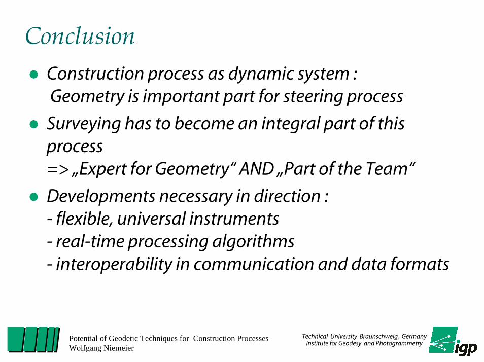
ConclusionConstruction process as dynamic system : Geometry is important part for steering process
Surveying has to become an integral part of this process => „Expert for Geometry“ AND „Part of the Team“
Developments necessary in direction :- flexible, universal instruments- real-time processing algorithms- interoperability in communication and data formats
Technical University Braunschweig, GermanyInstitute for Geodesy and Photogrammetry
Potential of Geodetic Techniques for Construction ProcessesWolfgang Niemeier
IAG Commission 4 „Positioning & Application“President : Chris Rizos
Within the 5 Subcommissions (SC) : SC 4.2 „Application of Geodesy to Engineering“
Within the 4 Working Groups (WG) of SC 4.2 :
WG 4.2.1 Measurement Systems for the Navigation of Construction Processes

Technical University Braunschweig, GermanyInstitute for Geodesy and Photogrammetry
Potential of Geodetic Techniques for Construction ProcessesWolfgang Niemeier
WG 4.2.1 : Measuring Systems for the Navigation of Construction ProcessesChair : Wolfgang NiemeierCo-Chair : Guenther Retscher
To promote research and stimulate new ideas and innovation for integrating geodetic measuring systems and concepts into the navigation and steering of construction processes. This area of research includes - a better understanding of geometrical requirements of
construction processes, - the further development of adequate sensor systems, - the development of algorithms for real-time applications, - the interaction between geometrical information and the
navigation/steering process and - the definition of interfaces.