Embed Size (px)
Citation preview
585Wolkersdorfer, Ch.; Khayrulina, E.; Polyakova, S.; Bogush, A. (Editors)
Open Pit Dewatering in Niger, from Groundwater Modeling Forecast to in-pit Water Management
Anthony Le Beux1, Amadou Boubacar2, Farook Assalack3, Pierre Grizard4
1Orano Mining, R&D Department , Paris La Défense, France, [email protected] 2Somaïr,Geology & Hydrogeology Department, Arlit, Niger
3Orano Mining, Geoscience Department, Arlit, Niger 4Orano Mining, Geoscience Department, Paris La Défense, France
AbstractSince 2016, Somaïr has been operating in northern Niger an open-pit mine to extract uranium from a sandstone reservoir hosting a regional groundwater aquifer. The first part of this article relates the geological and hydrogeological studies carried out to design the dewatering system. In the second part, we compare dewatering plans to the encountered settings during mining operation and describe actions carried out inside and outside the pit as operations progressed in order to keep the pit toe dry for mining.Keywords: Open-pit dewatering, Groundwater modelling, Water management, Uranium mining
Introduction Geological exploration work carried out in the 1950s in northern Niger, led to the development of a uranium mining industry operated by two companies, Somair and Cominak, subsidiaries of the Orano Group. The main mineralized reservoirs are located in the Arlit region, on the edge of the Tim Mersoi sedimentary basin, with an underground mining operation for Cominak and open-pit mining for Somaïr.
In 2012, Somaïr launched the project to operate the Artois pit, known to be the deepest open-pit of its portfolio. To ensure dry operations while mining a dewatering system needed to be engineered in a collaboration between Somaïr’s operation engineers and Orano Mining technical experts. Mining operations started in 2016 and will reach in 2019-2020 the ultimate expansion of the forecasted open-pit.
This article presents how the dewatering system was designed prior to mining operation and how operators were able to adapt the system during the recent exploitation.
Regional Setting The Somaïr mine site is located in the Arlit region of northern Niger. It lies in a plain relief, 80 km west of the Aïr granitic massif with an
average elevation of 430 m. The landscape is monotonous (regs with small pebbles and sandy areas) and uniformly flat. Climate is arid with an average annual rainfall around 40 mm/yr, annual average temperature around 28°C and pan evaporation ranging from 10 to 15 mm/day.
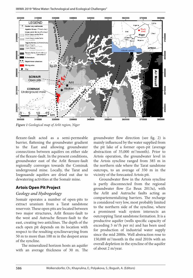
Geological formations of the Arlit region consist of sedimentary deposits of the Tim Mersoi basin, dated from Lower Paleozoic to the Cretaceous. This sedimentary basin presents a succession of marine and continental sedimentation environments, lying unconformably on the Aïr Massif Precambrian basement (see fig. 1). Sedimentary sequences alternate layers of sandstone and shale, regionally dipping to the west. The structural setting is characterized by North to South regional trending structures (Arlit flexure-fault) and East-North-East to West-South-West secondary faults (Autruche, Izerataguen flexure-faults).
Groundwater is hosted by three sandstone layers (Izegouande, Tarat and Guezouman) separated by shale layers but interconnected through major faults (Boko 2017). Prior to the commencement of mining operations, groundwater flow was from recharge area on the edge of the basin towards Arlit flexure-fault (Dodo 1992 and Le Beux 2013b). The
IMWA 2019 “Mine Water: Technological and Ecological Challenges”
586 Wolkersdorfer, Ch.; Khayrulina, E.; Polyakova, S.; Bogush, A. (Editors)
flexure-fault acted as a semi-permeable barrier, flattening the groundwater gradient to the East and allowing groundwater connections between aquifers on either side of the flexure-fault. In the present conditions, groundwater east of the Arlit flexure-fault regionally converges towards the Cominak underground mine. Locally, the Tarat and Izegouande aquifers are dried out due to dewatering activities at the Somaïr mine.
Artois Open Pit ProjectGeology and HydrogeologySomaïr operates a number of open-pits to extract uranium from a Tarat sandstone reservoir. These open pits are located between two major structures, Arlit flexure-fault to the west and Autruche flexure-fault to the east, creating two anticlines. The depth of the each open pit depends on its location with respect to the resulting synclinevarying from 50 m to more than 100 m in the deepest areas of the syncline.
The mineralized horizon hosts an aquifer with an average thickness of 30 m. The
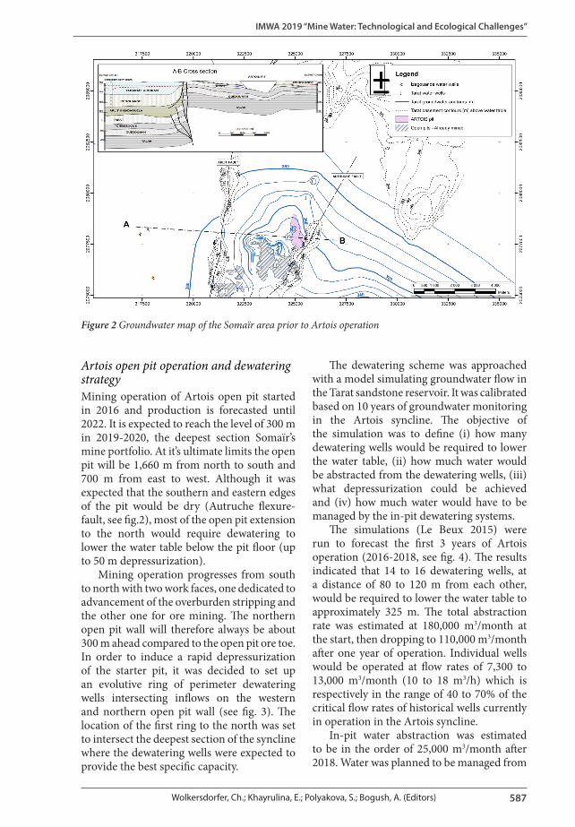
groundwater flow direction (see fig. 2) is mainly influenced by the water supplied from the pit lake of a former open-pit (average abstraction of 35,000 m3/month). Prior to Artois operation, the groundwater level in the Artois syncline ranged from 385 m in the northern side where the Tarat sandstone outcrops, to an average of 350 m in the vicinity of the forecasted Artois pit.
Groundwater flow in the Artois syncline is partly disconnected from the regional groundwater flow (Le Beux 2013a), with the Arlit and Autruche faults acting as compartementalizing barriers. The recharge is considered very low, most probably limited to the northern side of the syncline, where a prominent wadi system intersects an outcropping Tarat sandstone formation. It is a productive aquifer (wells specific capacity of exceeding 5 m3/h per m) and has been used for production of industrial water supply since the mid 2000s. Well abstraction rose to 150,000 m3/month in the mid 2010s with an overall depletion in the syncline of the aquifer of about 2 m/year.
Figure 1 Geological map of Arlit region, Niger
IMWA 2019 “Mine Water: Technological and Ecological Challenges”
587Wolkersdorfer, Ch.; Khayrulina, E.; Polyakova, S.; Bogush, A. (Editors)
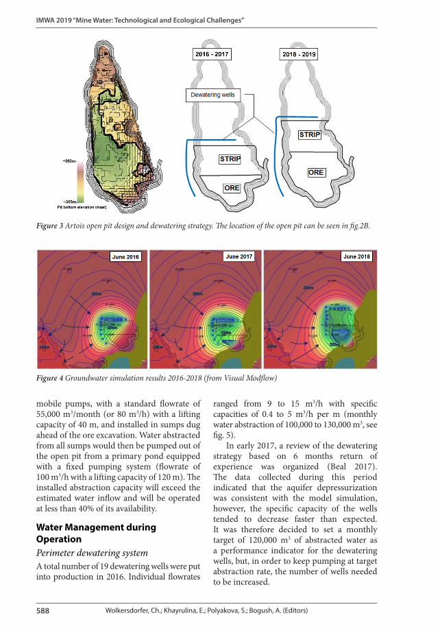
Artois open pit operation and dewatering strategyMining operation of Artois open pit started in 2016 and production is forecasted until 2022. It is expected to reach the level of 300 m in 2019-2020, the deepest section Somaïr’s mine portfolio. At it’s ultimate limits the open pit will be 1,660 m from north to south and 700 m from east to west. Although it was expected that the southern and eastern edges of the pit would be dry (Autruche flexure-fault, see fig.2), most of the open pit extension to the north would require dewatering to lower the water table below the pit floor (up to 50 m depressurization).
Mining operation progresses from south to north with two work faces, one dedicated to advancement of the overburden stripping and the other one for ore mining. The northern open pit wall will therefore always be about 300 m ahead compared to the open pit ore toe. In order to induce a rapid depressurization of the starter pit, it was decided to set up an evolutive ring of perimeter dewatering wells intersecting inflows on the western and northern open pit wall (see fig. 3). The location of the first ring to the north was set to intersect the deepest section of the syncline where the dewatering wells were expected to provide the best specific capacity.
The dewatering scheme was approached with a model simulating groundwater flow in the Tarat sandstone reservoir. It was calibrated based on 10 years of groundwater monitoring in the Artois syncline. The objective of the simulation was to define (i) how many dewatering wells would be required to lower the water table, (ii) how much water would be abstracted from the dewatering wells, (iii) what depressurization could be achieved and (iv) how much water would have to be managed by the in-pit dewatering systems.
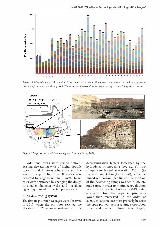
The simulations (Le Beux 2015) were run to forecast the first 3 years of Artois operation (2016-2018, see fig. 4). The results indicated that 14 to 16 dewatering wells, at a distance of 80 to 120 m from each other, would be required to lower the water table to approximately 325 m. The total abstraction rate was estimated at 180,000 m3/month at the start, then dropping to 110,000 m3/month after one year of operation. Individual wells would be operated at flow rates of 7,300 to 13,000 m3/month (10 to 18 m3/h) which is respectively in the range of 40 to 70% of the critical flow rates of historical wells currently in operation in the Artois syncline.
In-pit water abstraction was estimated to be in the order of 25,000 m3/month after 2018. Water was planned to be managed from
Figure 2 Groundwater map of the Somaïr area prior to Artois operation
IMWA 2019 “Mine Water: Technological and Ecological Challenges”
588 Wolkersdorfer, Ch.; Khayrulina, E.; Polyakova, S.; Bogush, A. (Editors)
mobile pumps, with a standard flowrate of 55,000 m3/month (or 80 m3/h) with a lifting capacity of 40 m, and installed in sumps dug ahead of the ore excavation. Water abstracted from all sumps would then be pumped out of the open pit from a primary pond equipped with a fixed pumping system (flowrate of 100 m3/h with a lifting capacity of 120 m). The installed abstraction capacity will exceed the estimated water inflow and will be operated at less than 40% of its availability.
Water Management during OperationPerimeter dewatering systemA total number of 19 dewatering wells were put into production in 2016. Individual flowrates
ranged from 9 to 15 m3/h with specific capacities of 0.4 to 5 m3/h per m (monthly water abstraction of 100,000 to 130,000 m3, see fig. 5).
In early 2017, a review of the dewatering strategy based on 6 months return of experience was organized (Beal 2017). The data collected during this period indicated that the aquifer depressurization was consistent with the model simulation, however, the specific capacity of the wells tended to decrease faster than expected. It was therefore decided to set a monthly target of 120,000 m3 of abstracted water as a performance indicator for the dewatering wells, but, in order to keep pumping at target abstraction rate, the number of wells needed to be increased.
Figure 3 Artois open pit design and dewatering strategy. The location of the open pit can be seen in fig.2B.
Figure 4 Groundwater simulation results 2016-2018 (from Visual Modflow)
IMWA 2019 “Mine Water: Technological and Ecological Challenges”
589Wolkersdorfer, Ch.; Khayrulina, E.; Polyakova, S.; Bogush, A. (Editors)
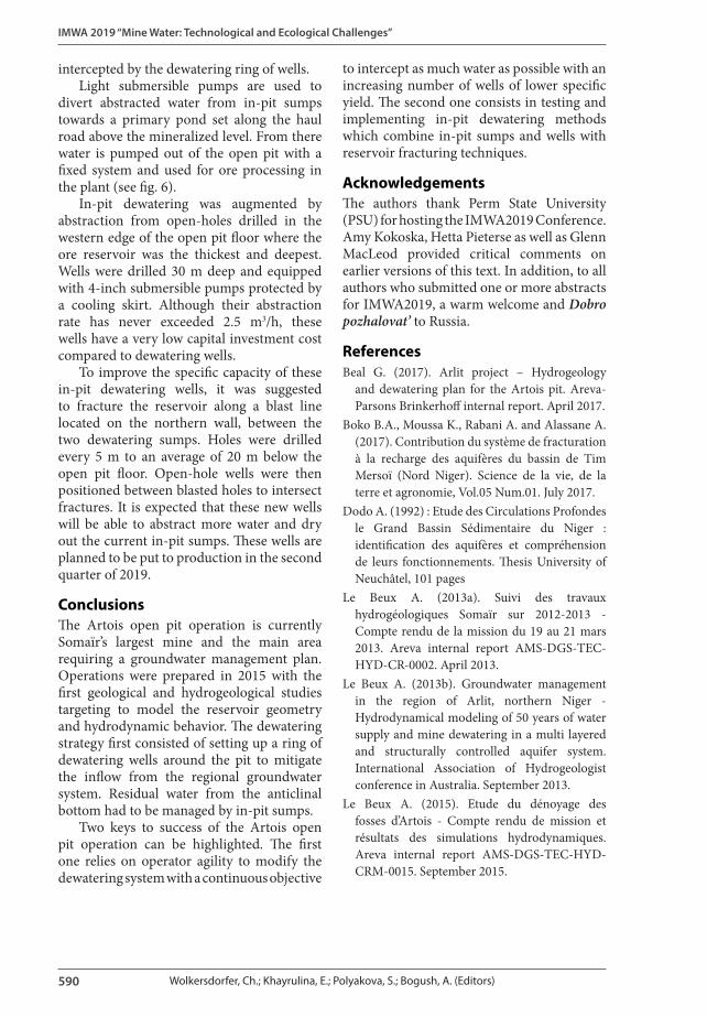
Additional wells were drilled between existing dewatering wells of higher specific capacity and in areas where the syncline was the deepest. Individual flowrates were expected to range from 5 to 10 m3/h. Target costs were optimized by changing the design to smaller diameter wells and installing lighter equipment for the temporary wells.
In-pit dewatering systemThe first in-pit water seepages were observed in 2017 when the pit floor reached the elevation of 325 m in accordance with the
depressurization targets forecasted by the hydrodynamic modeling (see fig. 4). Two sumps were blasted at elevation 320 m (to the west) and 308 m (to the east), below the mined ore horizon (see fig. 6). The location of the dewatering sumps was set in low ore grade area, in order to minimize ore dilution in excavated material. Until early 2019, water abstraction from the in-pit sumpsremains lower than forecasted (in the order of 20,000 m3 abstracted) most probably because the open pit floor acts as a large evaporation zone and water inflows were largely
Figure 5 Monthly water abstraction from dewatering wells. Each color represents the volume of water extracted from one dewatering well. The number of active dewatering wells is given on top of each column.
Figure 6 In-pit sumps and dewatering well location (Aug. 2018)
IMWA 2019 “Mine Water: Technological and Ecological Challenges”
590 Wolkersdorfer, Ch.; Khayrulina, E.; Polyakova, S.; Bogush, A. (Editors)
to intercept as much water as possible with an increasing number of wells of lower specific yield. The second one consists in testing and implementing in-pit dewatering methods which combine in-pit sumps and wells with reservoir fracturing techniques.
AcknowledgementsThe authors thank Perm State University (PSU) for hosting the IMWA2019 Conference. Amy Kokoska, Hetta Pieterse as well as Glenn MacLeod provided critical comments on earlier versions of this text. In addition, to all authors who submitted one or more abstracts for IMWA2019, a warm welcome and Dobro pozhalovat’ to Russia.
References Beal G. (2017). Arlit project – Hydrogeology
and dewatering plan for the Artois pit. Areva-Parsons Brinkerhoff internal report. April 2017.
Boko B.A., Moussa K., Rabani A. and Alassane A. (2017). Contribution du système de fracturation à la recharge des aquifères du bassin de Tim Mersoï (Nord Niger). Science de la vie, de la terre et agronomie, Vol.05 Num.01. July 2017.
Dodo A. (1992) : Etude des Circulations Profondes le Grand Bassin Sédimentaire du Niger : identification des aquifères et compréhension de leurs fonctionnements. Thesis University of Neuchâtel, 101 pages
Le Beux A. (2013a). Suivi des travaux hydrogéologiques Somaïr sur 2012-2013 - Compte rendu de la mission du 19 au 21 mars 2013. Areva internal report AMS-DGS-TEC-HYD-CR-0002. April 2013.
Le Beux A. (2013b). Groundwater management in the region of Arlit, northern Niger - Hydrodynamical modeling of 50 years of water supply and mine dewatering in a multi layered and structurally controlled aquifer system. International Association of Hydrogeologist conference in Australia. September 2013.
Le Beux A. (2015). Etude du dénoyage des fosses d’Artois - Compte rendu de mission et résultats des simulations hydrodynamiques. Areva internal report AMS-DGS-TEC-HYD-CRM-0015. September 2015.
intercepted by the dewatering ring of wells. Light submersible pumps are used to
divert abstracted water from in-pit sumps towards a primary pond set along the haul road above the mineralized level. From there water is pumped out of the open pit with a fixed system and used for ore processing in the plant (see fig. 6).
In-pit dewatering was augmented by abstraction from open-holes drilled in the western edge of the open pit floor where the ore reservoir was the thickest and deepest. Wells were drilled 30 m deep and equipped with 4-inch submersible pumps protected by a cooling skirt. Although their abstraction rate has never exceeded 2.5 m3/h, these wells have a very low capital investment cost compared to dewatering wells.
To improve the specific capacity of these in-pit dewatering wells, it was suggested to fracture the reservoir along a blast line located on the northern wall, between the two dewatering sumps. Holes were drilled every 5 m to an average of 20 m below the open pit floor. Open-hole wells were then positioned between blasted holes to intersect fractures. It is expected that these new wells will be able to abstract more water and dry out the current in-pit sumps. These wells are planned to be put to production in the second quarter of 2019.
ConclusionsThe Artois open pit operation is currently Somaïr’s largest mine and the main area requiring a groundwater management plan. Operations were prepared in 2015 with the first geological and hydrogeological studies targeting to model the reservoir geometry and hydrodynamic behavior. The dewatering strategy first consisted of setting up a ring of dewatering wells around the pit to mitigate the inflow from the regional groundwater system. Residual water from the anticlinal bottom had to be managed by in-pit sumps.
Two keys to success of the Artois open pit operation can be highlighted. The first one relies on operator agility to modify the dewatering system with a continuous objective


![Telecommunication Products - Trendtek jointing pits.pdf · [01] UG2006 - P6 Pit UG2007 - P7 Pit UG2008 - P8 Pit UG2900 - P9 Pit UG2001 - P1 Pit UG2002 - P2 Pit UG2003 - P3 Pit UG2004](https://img.pdfslide.net/doc/110x75/5a7969077f8b9ab9308d3433/telecommunication-products-jointing-pitspdf01-ug2006-p6-pit-ug2007-p7-pit.jpg)