Embed Size (px)
Citation preview
Kalmiopsis Volume 17, 2010 17
Swala-lahos is the English interpretation of an aboriginal name for Saddle Mountain in south central Clatsop County (Giesecke 1991), the site of a Chinook origination story, and
the legendary home of the Thunderbird. Saddle Mountain rises 3,266 feet to three peaks (the saddle), and is the tallest mountain in the Coast Range between the Olympic Mountains and a Miocene basalt plateau in Tillamook County (Niem and Niem 1985, Walsh et al. 1987).
The general boundaries of the Swala-lahos Floristic Area (SFA) begin on a north line running east in Pacific County, Washington, from the entrance to Willapa Bay east up the Willapa River, which then turns south to follow the eastern boundary of Pacific and Clatsop counties, bisecting Wahkiakum County west of the Skamokawa River, and continuing south just east of Nicolai Ridge on the Clatsop County line to the Nehalem River. It then turns west on the north side of the Nehalem River, taking in Oswald West State Park and the southern slopes of Neahkahnie Mountain in north Tillamook County, Oregon.
This area lies mostly within the summer fog zone, west of the Coast Range in northwestern Oregon and adjacent southwestern
Washington. Bisected by the Columbia River and flanked on the west by the Pacific Ocean, this is a region of cool, relatively rain-free summers and mild, wet winters (Maas 2008, Taylor and Hatton 1999). A climatic mix of summer fog and winter rain supports abundant forest epiphytes. At sea level, three to ten inches of rain typically fall each month during the wet season; less than one inch per month in the dry season. Rain-free periods in the summer typically last 30 to 50 days, but may exceed 90 days. Annual precipitation increases with elevation: near sea level, 85 to 90 inches are typical; elevations above 2,000 ft. normally receive more than 150 inches.
The SFA encompasses about 1,800 square miles, and contains extensive coniferous forests, as well as a variety of wetland, riparian and tidal habitats, and grasslands ranging from sea cliff to montane rocky outcrops, and high elevation balds. This area is generally too wet for Oregon white oak (Quercus garryana) and Pacific madrone (Arbutus menziesii) in the western half of the coastal mountains, and provides habitat for most of the known populations of Queen-of-the-forest (Filipendula occidentalis).
OregOn Plants, OregOn Places
Botanizing in the Swala-lahos Floristic Area
Kathleen SaycePO Box 91, Nahcotta WA 98637
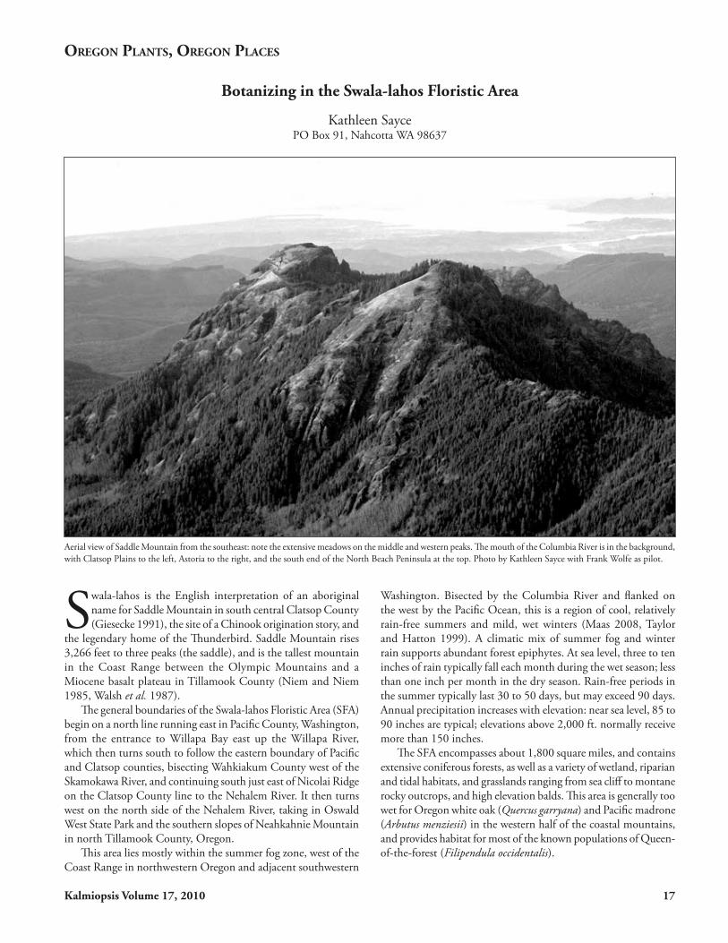
Aerial view of Saddle Mountain from the southeast: note the extensive meadows on the middle and western peaks. The mouth of the Columbia River is in the background, with Clatsop Plains to the left, Astoria to the right, and the south end of the North Beach Peninsula at the top. Photo by Kathleen Sayce with Frank Wolfe as pilot.

18 Kalmiopsis Volume 17, 2010
Land Use
In this article, I use the term “coast range” for the mountains both north and south of the Columbia River, although in Washington, these coastal mountains are called the Willapa Hills. These ranges share geology and geomorphology, climate, soils and vegetation. They also share historic and present land use patterns, with farming in the river valleys, cranberry farms among the sand dunes, commercial forestry in the timbered hills, fishing in the rivers, and resort and residential areas along the Pacific coastline. The SFA is near the north end of a larger geologic unit, the Coast Range Zone,
which extends south along the coast from the Chehalis River in Washington to the western Klamath Mountains in southern Oregon. The larger Coast Range Zone is commonly recognized as a geologic and plant community unit, and often includes, floristically, the Olympic Mountains (Pojar and MacKinnon 1994).
Unlike the Olympic and Cascade mountain ranges, there are few conservation areas within this region and none are large (see map). Including state and federal parks and small private holdings, no individual conservation unit exceeds ten thousand acres in size. Conserved lands represent less than ten percent of the landscape; the remainder (public and private) is managed for commercial tim-
ber, agriculture and shellfish. Some forest units have been harvested repeatedly, beginning more than 150 years ago. The last large stands of old growth on private land were logged as recently as the 1980s, and these are now in their first regenera-tion cycle. Surviving old growth comprises less than three per-cent of the total forestland area (Sayce 1998).
The effect of fire on ecosys-tems was historically different south of the Nehalem River Valley, where native people regularly set fires (Agee 1996), in contrast to the northern coast region, where intervals between wildfires were much longer. Inland, in the Willamette–Puget Trough, which has a drier climate, tribal burning to clear land was also more common.
The major landscape distur-bances today are urbanization, roads and timber harvesting. Urban areas are concentrated at low elevations along the ocean and rivers. Commercial forests are regularly logged on a 35 to 50 year interval. Logging roads average more than six linear miles per square mile of forestland; four paved highways cross the Coast Range in the SFA (Sayce 1998). There are no significant roadless areas and only a few miles of un-developed coastline. Four key landscape features distinguish the SFA from the rest of the Pacific Northwest region: 1) it lies south of the line of Pleis-tocene continental ice; 2) the mountains are either formed of Miocene flood basalts or
Map of Swala-lahos Floristic Area, with conservation areas shown by black hatching. Analisa Fenix, Chief Cartographer, Ecotrust, Portland, Oregon, assembled databases to provide a general map of the region, including public parks and public and private conservation areas. Data layers came from Ecotrust, Washington Department of Natural Resources, Washington Parks and Recreation Commission, National Park Service, The Nature Conservancy, Pacific County, and US Fish and Wildlife Service. Some privately conserved lands and mitigation areas are not shown.

Kalmiopsis Volume 17, 2010 19
are capped by this material and surrounded by extensive marine sediments; 3) its plant communities are not as affected by regular wildfire as are those to the south and east; and 4) most of the area is commercial forestland, managed for timber under short rotation regimes.
A Treasure Trove for Botanists
As a member of the Vancouver Expedition (1790-1794), Scottish surgeon Archibald Menzies (1754-1842) was likely the first naturalist to observe plants in the region. He returned to Britain with notes and seeds, stimulating others to take a closer look at flora of the west coast of North America. Meriwether Lewis (1774-1809) was the next known visitor; the Corps of Discovery came down the Columbia River in the fall of 1805, built Fort Clatsop, and stayed until the spring of 1806 (Eid and Johnson 2005). Lewis spent much of a rainy winter studying and sketching local trees. David Douglas (1799-1834) arrived in 1825 on a quest for new and novel plants for the London Horticultural Society; he explored the lower Columbia River with fellow Scotsman John Scouler (1804-1871), and returned in 1832-33, just before his last trip to Hawaii. Two naturalists on the Astor Expedition, American John K. Townsend (1809-1851) and English botanist/zoologist (and Harvard professor) Thomas Nuttall (1786-1859) arrived in 1834.
Thomas Jefferson Howell (1842-1912), the region’s first resident botanist, began his study of plants on Sauvie Island where his family farmed, and visited Clatsop County in 1887. Late in the 19th century, Louis Henderson (1853-1942) summered in Ilwaco, Washington, where his wife’s family lived, and made several notable collections in the Columbia River Estuary, including his namesake checkermallow, Sidalcea hendersonii (Gisler and Love 2005). While at the University of Oregon, Henderson returned several times to
Access for Botanical Exploration
Until 1991, private forestlands and roads were open to the public. Private forestland owners enjoyed property tax breaks for providing recreational opportunities to the public, and were generally held not liable for accidents. Weekend trips into the hills were traditional recreation for local residents; activities included fossil hunting, fishing, hunting, camping, or just driving the roads. (My family and our neighbors camped every summer on a river in the Coast Range; one of my earliest memories is floating on that stream in a tethered inner tube.) However, open access had some negative aspects: vandalism of equipment; dumping of trash along logging roads and in streams was, and is, a chronic problem; accidents in remote areas are without means of emergency assistance; private vehicles are a hazard to heavily-laden log trucks on these narrow roads.
Open access ended in the 1990s. Teenagers in Astoria had developed a game they called ‘looping,’ driving logging roads at night at high speeds, often while drinking. In 1991, two teens “looping” on a logging road south of Astoria ran their car off the road, fell several hundred feet, and died. Their parents sued the landowner for wrongful death, and won a settlement of $8.5 million in 1993. Two years later this verdict was overturned on the grounds that access to the forests was a community good, so the landowner could not be held liable for accidents (Lavis & Navarro vs. Cavenham Forest Industries 1993, Clatsop County Circuit Court). But, within months of the initial accident, the first of thousands of gates went up across logging roads. Even though the original settlement was overturned, gates have remained closed, continuing to bar access.
Gate technology keeps pace with those who desire entry enough to use bolt cutters, pull out or ram the gates with multiple vehicles, lift the gates out of the ground, or go around the gate ends. Regulated access is now the normal condition. State authorities may also fine people for trespass who drive gated logging roads without permission.
The impact is profound for naturalists. For nearly two decades, biological surveys have been limited to those sponsored by landowners, those with personal relationships with landowners, or to those willing to walk in on foot and stay off main roads. In other words, the only effective, ethical access for visitors is to maintain good personal relations with the landowners and enter with permission. The North Coast Land Conservancy (NCLC), led by Neal Maine, has worked with private owners for years to allow biological surveys on their lands. In exchange, the NCLC does not abuse this privilege; they do not use survey findings to force owners to change management practices or attack them publicly for land management policies. The landowners are the first to be informed of any important biological discoveries. While the survey group and NCLC are committed to conservation of fragile and important landscapes, maintaining a good working relationship with landowners comes first.
Type specimen of Cardamine pattersonii from OSU herbarium.

20 Kalmiopsis Volume 17, 2010
Saddle Mountain and other northwestern Oregon sites. One of his students, John Rollo Patterson, discovered Saddle Mountain bittercress (Cardamine pattersonii) in 1928, which Henderson named for him (Henderson 1930).
Other early 20th century botanists who collected in the SFA included Wilhelm N. Suksdorf (1867-1935), Morton Eaton Peck (1871-1959), Martin Woodlock Gorman (1853-1926), Carl C. Epling (1894-1968), L.N. Goodding (1880-1967), Le Roy Abrams (1874-1956), Harold St. John (1892-1991), G.B. Rossbach (1910-), W. Bridge Cook (1908-1991) and Helen Gilkey (1886-1972).
After World War II, Professors C. Leo Hitchcock, LeRoy E. Detling and Kenton Chambers botanized extensively in the SFA, along with many students. Detling, and later Chambers,
wrote papers on the flora of montane balds of northwestern Oregon (Detling 1953, Chambers 1973). Detling studied plant distributions, particularly in xeric regions, and was the first to write about an interesting overlap of floras from other areas in the SFA. He noted that some species extended no further north, or south, than the northwest Oregon Coast Range (Detling 1954). Chambers expanded on this theme a few decades later, when he inventoried additional peaks, including Angora and Sugarloaf (Chambers 1974). Two endemic species honor the work of these botanists in northwestern Oregon: Micranthes hitchcockiana (formerly Saxifraga hitchcockiana (Elvander 1984)), and Castilleja chambersii (Egger and Meinke 1999).
Cathy Maxwell began compiling site lists for the Willapa Hills,
Recollections of Clatsop County BotanyKenton L. Chambers
Sometime in my early years as Curator of the Oregon State University Herbarium, I was advised by Mr. Oliver Matthews1, “You ought to visit Onion Peak in Clatsop County; I think you’ll find something interesting.” An opportunity to do so arose in 1971, when a student at OSU, Dennis Rittenback, offered to guide me there through the recently logged forestlands
surrounding the peak. Dennis was a native of Cannon Beach and had himself been involved in these logging operations, which, as we found, had thoroughly “skinned” what must have been a magnificent old-growth forest of spruce, fir, and cedar trees on all the steep slopes around the mountain. Reaching the peak was easy over a network of logging roads. From a landing at the base of the great summit monolith, we climbed the west side, where only a few years’ shrub growth impeded the trail through the fissured rock face. According to Kathleen Sayce, this route is now thoroughly blocked by a thicket of 10-foot-tall salmonberry and blueberry shrubs. The summit, 2,818 ft. high, was a pristine wildflower garden, occupying cliffs, talus slopes, and a grassland about 2 acres in size, formed on thin soil over the basalt substrate. Such habitats are very similar to those on adjacent Saddle Mountain, but on Onion Peak they are much smaller in total area. After this first visit, I made three further excursions up Onion Peak, accompanied first by colleagues from OSU, Bob Frenkel and Fred Rickson, and then by my wife Henrietta and our two children, ages 10 and 12. The extremely difficult ascent route encountered by very recent visitors there was obviously much simpler back when logging of the peak had only recently been completed.
These high Northwest peaks project like islands from a sea of dense coniferous forests, and their unusual floras, especially of herbaceous plants, include some endemic species as well as various taxa from the Olympics and Alaska, which are at their southern limit in this corner of Oregon. Still other species are disjunct here from the Cascades and farther east. Among the northern taxa reaching their southern limits, we found Senecio (now Packera) flettii, Lewisia columbiana var. rupicola, Prenanthes alata, Erigeron peregrinus var. peregrinus, and Cladothamnus pyroliflorus. The Senecio was a first report for Oregon, in fact. The taxa endemic to Northwest Oregon were Cardamine pattersonii and Saxifraga (now Micranthes) hitchcockiana, both previously known only on Saddle Mountain, as well as Filipendula occidentalis, of the Trask and Wilson Rivers region. There were two novel elements, which have since come under taxonomic investigation. In the gravelly grassland was a dwarf Dodecatheon (shooting-star), known already from Saddle Mountain, where it was going by the name D. pulchellum. Recently, further study and comparison of these plants with ro-bust, low-elevation populations from along the Trask River have led to the description of a new species, Dodecatheon austrofrigidum. (illustrated on p. 25) The range of this taxon extends north to Mt. Colonel Bob in the southern Olympic Mountains. Although I had thought that, morphologically, its closest relationship was with D. frigidum of Alaska and northern British Columbia, DNA studies tie it closer phylogenetically with D. dentatum, the white-flowered, waterfall-loving species of the northern Cascades.
Also of interest was a form of Castilleja, discovered on cliffs at the summit of the peak, which I could not place in any described species. It was sent to an expert at an eastern U. S. institution, who suggested that it might be a new taxon, but no steps were taken to publish a description of it. Not until 1999 did Mark Egger and Bob Meinke examine it again, from my collections plus new material on Angora Peak just south of Onion, and in their publication they named it as Castilleja chambersii. The species is appar-ently a very local endemic, known at present only from Onion and adjacent Sugarloaf and Angora Peaks.
My publication comparing the flora of Onion Peak with that of Saddle Mountain appeared in 1973 (Chambers 1973). At the same time, Rittenback guided me to Sugarloaf Mountain, 2,874 ft. high and 3.4 miles north of Onion, having a small grassy bald at its summit. There we found some of the same endemic and disjunct taxa, including Castilleja chambersii, Cardamine pattersonii, Micranthes hitchcockiana, Packera flettii, Lewisia columbiana var. rupicola, Erigeron peregrinus var. peregrinus, and Cladothamnus pyroliflorus. A report was published in Madroño (Chambers 1974). Over the years, numerous plant collectors have visited Saddle Mountain, and from their specimens and my own collections, I have assembled an updated vascular plant checklist of 325 taxa, which is available from the author at <[email protected]>1 Oliver Matthews was the dendrologist/amateur botanist who discovered Pinus sabiniana in Oregon (Kalmiopsis 16:2-4).

Kalmiopsis Volume 17, 2010 21
north of the Columbia River, late in the 20th century. The Washington Native Plant Society published her species list for southwestern Washington in Douglasia (Maxwell 1991). During the same period, Duncan Thomas focused on the Columbia River Estuary (Thomas 1984) and John Christy on wetlands (Christy and Puttera 1993, Christy 2004). I also started cataloging wetland and coastal plants during this period, slowly moving into the hills on both sides of the Columbia River. After a while I recognized a similarity in species distributions north and south of the river, and began to see the region as floristically distinct, compared to adjacent areas to the north, south and east.
Plant Communities and Species Diversity
Even along the coast, dry periods in the summer interact with variations in topography and soils to enhance upland plant diversity, and through these plant communities, diverse faunal habitats. There are three distinct floristic components, with some overlap between them. These include, from Detling (1954): 1) Boreal – A boreal and high latitude component otherwise seen more fully in the Olympic Mountain Range, fifty miles north, and Cascades, sixty miles east, and across Boreal North America; 2) Xeric/Continental – A dry side component, which reaches greater expression in the east Columbia Gorge, sixty miles east; and 3) Californian – the California Floristic Province, which generally extends as far north as the Klamath and Coast ranges of southwestern Oregon.
Species from each of these floristic provinces appear in the SFA, where many of them reach the limits of their distribution (i.e., the southern limit for boreal species, the northern limit for California species, and the western limit for Continental species. In addition to those three floristic components, there are coastal species and plant communities whose distributions along the Pacific Coast end within the SFA and extend no farther inland than the Coast Range. There are also endemic species. For a species list for the Swala-lahos Floristic Area, see www.reachone.com/columbiacoastplants; this website also has lists for public parks.
Coniferous and Hardwood Forests
The SFA is within the coastal Pacific Northwest rain forest biome. Dominant conifers include western hemlock (Tsuga heterophylla), western red cedar (Thuja plicata), Douglas fir (Pseudotsuga menziesii), Sitka spruce (Picea sitchensis), and above 1,500 ft., Noble fir (Abies procera) and Pacific silver fir (A. amabilis) (Franklin and Dyrness 1988, McCain and Diaz 2002). The highest site classes (sites of fastest tree growth) straddle the Columbia River along the West Coast, and peak in Clatsop County, Oregon, and
Pacific County, Washington, where deep old soils, ample rainfall and moderate temperatures allow trees to grow almost year round (Soil Conservation Service 1986, 1988).
While hardwoods such as red alder (Alnus rubra) are common understory and colonizing species, mixed hardwood forests are largely confined to river bottomlands, e.g., along the Columbia River. In these floodplains, red alder, big-leaf maple (Acer macrophyllum), black cottonwood (Populus trichocarpa), Oregon ash (Fraxinus latifolia), and several willow species (Salix) are common. Sitka spruce occurs on river floodplains where high winter tides may cover its large buttressed roots, the source of its other common name, tidewater spruce. Western hemlock and western red cedar also grow on floodplains in slightly higher sites, usually above the reach of winter high tides.
Wetlands
Inland from the ocean coast, with rock reefs, sea cliffs, ocean beaches and estuaries, wetlands extend upriver from salt to freshwater tidal areas, floodplains, perched bogs, marshes, and up into small streams, springs and seeps in the mountains. Almost every temperate hydrology regime known can be found here, each with its associated plant community (Thomas 1984, Kunze 1994, Howarth 1995, Eid 1996, Christy 2004). This diversity includes vernal pools and winter flowing streams and seeps on the beaches and seacliffs, seasonal and perennial streams in the coast range, true bogs, and fens.
The Columbia River is tidal throughout the Swala-lahos area. Tidal regimes include saltwater, a shifting brackish water interface, and freshwater tidal areas. Plant communities include tide flats, beaches, marshes, dense shrubby thickets and swamps worthy
A common wetland forest community is characterized by red alder (Alnus rubra) and slough sedge (Carex obnupta). Minor components include ladyfern (Athyrium filix-femina), Hookers willow (Salix hookeriana) and Pacific crabapple (Malus fusca). Photo by Kathleen Sayce, west of Oysterville, Washington.
22 Kalmiopsis Volume 17, 2010
of Gulf Coast bayous (complete with nutria, and lacking only alligators for ambiance), along with diked, tidegated, ditched, drained and otherwise altered river islands and adjacent marshy to forested flats, now modified for agriculture.
Annual natural high flow on the Columbia River was driven by snowmelt and occurred from late spring to early summer. This pattern was altered by water containment structures. Fall and winter flow increased due to systematic water releases for hydropower production and shipping (Ebbesmeyer and Tangborn 1992). This modulated both freshwater surges and saltwater intrusion and altered plant and animal distributions. It also ended episodic sediment replenishment of associated wetlands during major floods.
The Columbia is a major shipping river. Duncan Thomas (1984), and later Cathy Maxwell (1991) found several dozen newly introduced species when they investigated beaches and islands on the Columbia River. Additional species new to this area continue to appear (D. Giblin, and Sayce, personal observations).
The dune fields on both sides of the Columbia River Entrance form complex fens, locally called bogs;
wetlands in these dune fields are connected by groundwater under the surface topography of undulating dune and swale (Thomas 1995, Soil Conservation Service 1986, 1988). Dunes and swales run north-south, in alternating strips. The swales range from coastal wetland forests (swamps) to willow thickets, sedge meadows, floating sphagnum and sedge mats, and shallow to deep lakes (Howarth 1995, Eid 1996). Shallow, seasonal ponds in young dunes near the ocean beaches have vernal pool structure, and often contain Oregon fairy shrimp (Eubranchipus oregonus) (Russell Lewis, pers. comm.)
Slow-moving tidal streams drain the fens; these streams are locally called sloughs or, more colloquially, creeks. Some streams run all year; others flow only during the wet season. Urban and farm development prompted the installation of miles of ditches, dikes and weirs, which generally lower the winter water table. One slough had its course altered from west to north: the
Skipanon River drains Cullaby Lake, south of Warrenton, Oregon and now flows north to the Columbia River instead of west to the Pacific Ocean. Cullaby Lake and Loomis Lake (between Long Beach and Ocean Park, Washington) have weirs to control water flow and
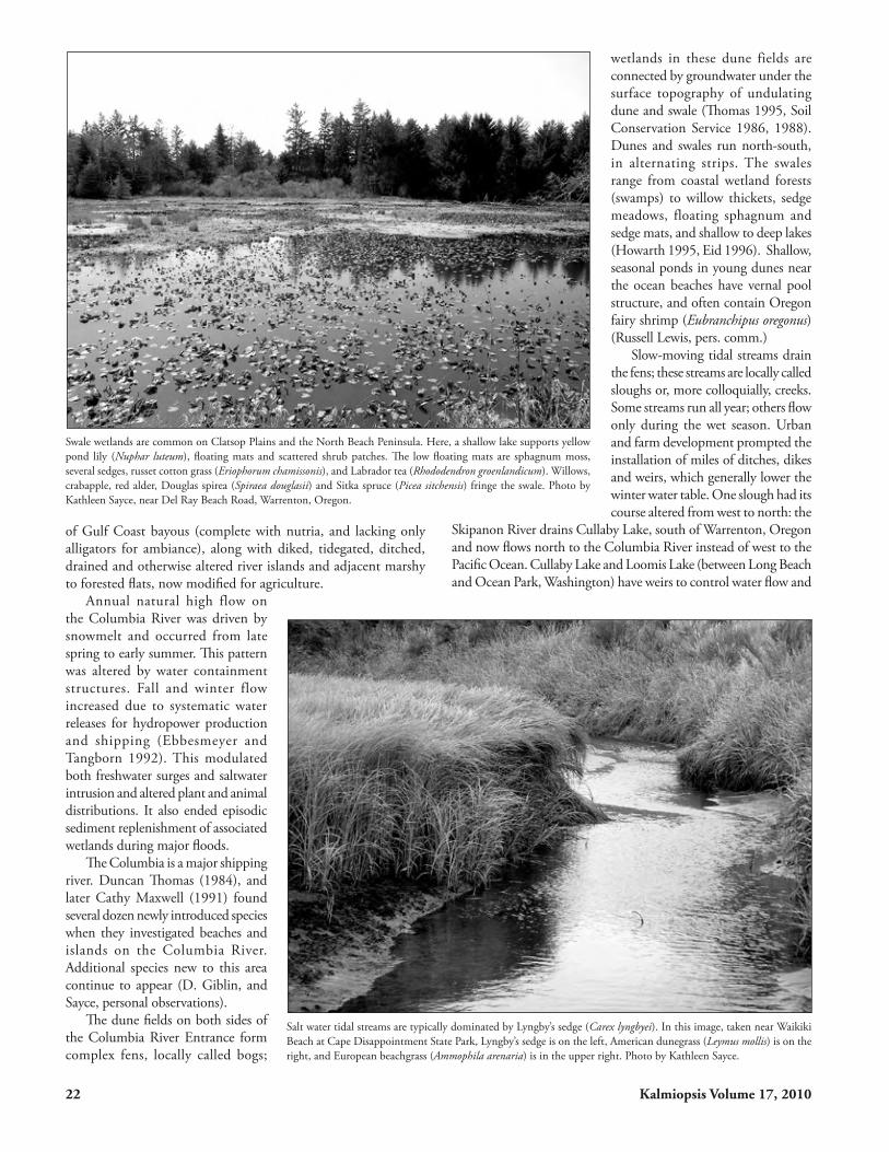
Swale wetlands are common on Clatsop Plains and the North Beach Peninsula. Here, a shallow lake supports yellow pond lily (Nuphar luteum), floating mats and scattered shrub patches. The low floating mats are sphagnum moss, several sedges, russet cotton grass (Eriophorum chamissonis), and Labrador tea (Rhododendron groenlandicum). Willows, crabapple, red alder, Douglas spirea (Spiraea douglasii) and Sitka spruce (Picea sitchensis) fringe the swale. Photo by Kathleen Sayce, near Del Ray Beach Road, Warrenton, Oregon.
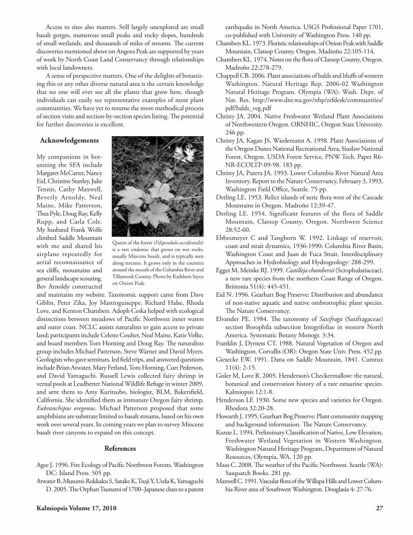
Salt water tidal streams are typically dominated by Lyngby’s sedge (Carex lyngbyei). In this image, taken near Waikiki Beach at Cape Disappointment State Park, Lyngby’s sedge is on the left, American dunegrass (Leymus mollis) is on the right, and European beachgrass (Ammophila arenaria) is in the upper right. Photo by Kathleen Sayce.

Kalmiopsis Volume 17, 2010 23
to impound water year round. These weirs also stabilize marshes around both lakes. Tidegates limit the intrusion of salt water along the ocean, Columbia River, and other estuaries.
Some lakes and older marshes have floating moss and sedge mats. Wetlands fill with peat deposits as they age, and go through a succession of plant communities from open water to floating sedge and moss mats along the edges, to covered mats over water, add marsh species, add shrub species, and finally host trees. The oldest wetlands are peat-filled, with trees, shrubs and marsh plants in diverse complexes. Highly diverse wetland communities include Gearhart Bog (Oregon), and wetland complexes associated with Cullaby Lake (Oregon) and Loomis Lake (Washington).
The youngest wetlands are closest to the ocean, have less plant diversity, and are usually dominated by slough sedge (Carex obnupta). Shrubs appear in wetlands more than fifty to seventy years old. Douglas spirea (Spiraea douglasii) is a typical dominant species in low elevation wet shrublands, along with several willow species. Shrub communities are also found on mineral and organic soils too wet for trees, but not so wet that only grasses and sedges will grow. Shrub communities are found on perched wet soils, talus, and rocky shelves. Typical shrubs include several Vaccinium species, salmonberry (Rubus spectabilis) and willows (Salix).
Streams in the Coast Range are numerous and highly dissected; fifth order streams are typical of local stream systems. Periodic mass wasting is common due to high precipitation, high winter stream flow, and a predominance of poorly consolidated marine sediments lining modern stream corridors. Sandstone and basalt outcrops can be found, but are not the dominant geologic materials through which streams cut. Streams are longer on the west side of the mountains, because there is more rainfall on this side to cut stream headwalls eastward. A rare endemic, Queen-of-the-forest (Filipendula occidentalis) grows on perennially wet basalt, usually along streams. Distributions of that species, long-awned sedge (Carex macrochaeta) and Cope’s Giant Salamander (Dicamptodon copei)
are limited to a few basalt-wall-lined streams and rock seeps in the SFA (Michael Patterson pers. comm.).
Meadows
Meadows or wildflower prairies appear in three different topographic areas: in sand dunes along the ocean, on sea cliffs, and in dry balds on shallow, rocky soils at higher elevations. Except for modern (young) dunes, these communities have high plant species diversity.
Dune prairiesHistorically, dune prairies supported a diverse array of native species. Inten-tional and accidental introductions of European and American beachgrasses (Ammophila arenaria, A. breviligulata) for sand stabilization along the Pacific Ocean in the 19th and 20th centuries significantly reduced plant diversity in
the dunes (Christy et al. 1998). Non-native beach grasses effectively trap sand, but also crowd out native plants and animals that require open sandy soils to thrive. Dense monocultures of Ammophila re-placed the patchy, open communities of native American dunegrass (Leymus mollis). As a result, few remnants of native coastal dune prairie remain, and of those that do, all are now maintained by active suppression of weeds, shrubs and trees (Sayce 1990). None are now in immediate proximity to the ocean, due to urbanization, and changes in hydrology and sand deposition on ocean beaches. As expected, plant community changes have also impacted animals, several of which are now ESA-listed. Although full historic plant diversity cannot be regained, restoration efforts have maintained and improved several hundred acres of remnant high quality dune prairies (Camp Rilea and several NCLC units on Clatsop Plains, a small prairie north of Long Beach) and sandy, beach grass-reduced faunal habitat at Leadbetter Point (Pearson et al. 2009, Ritchie and Brennan 2010).
Sea Cliff MeadowsSea cliff meadows occur north of the Columbia River on Cape Disappointment headlands, and south from Tillamook Head to Manzanita, Oregon in the SFA (Ripley 1984, Sayce and Eid 2004, Chappell 2006). These meadows are exposed, windy, winter-wet, summer-dry, salt-washed sites. They are sandwiched between sheer basalt cliffs and seabird rookeries on the ocean side, and coniferous forests on the upland side. Cryptogams are numerous on open rocks, and vascular plants drop out quickly as exposure rises to salt and wind. Plant communities go from forest to herbaceous meadow to cliff face, often in only a few steps. Sea cliff meadows become progressively more extensive and diverse going south into California. In the SFA, they are largely limited to narrow strips and patches. Farther north, conifers dominate the coastal fringe to the water line. Similar meadows appear on inland waters of Washington and British Columbia, with different species composition and substrates, and much lower annual
Summer dunes at Benson Beach, Cape Disappointment State Park, with North Head lighthouse in the background. Dunes are dominated by American beachgrass (Ammophila breviligulata) and European beachgrass (Ammphila are-naria), introduced grasses that have completely changed species composition of the dunes. The meadow to the right of the lighthouse is a Pacific reedgrass (Calamagrostis nutkaensis) community. The Cape Disappointment headland is the northernmost occurrence of this plant community on the Pacific Coast. Photo by Kathleen Sayce.

24 Kalmiopsis Volume 17, 2010
precipitation (Chappel 2006, A. Ceska pers. comm.). Two sea cliff meadow types grow as far north as Cape
Disappointment: a Pacific reed grass (Calamagrostis nutkaensis) community and a red fescue/stonecrop community, dominated by Oregon fescue (Festuca roemeri) and Oregon stonecrop (Sedum oreganum) (Ripley 1984, Sayce and Eid 2004). While these species range into Canada and Alaska, these meadow communities extend no farther north than Cape Disappointment.
Also at the north end of distribution at Cape Disappointment are coyotebrush (Baccharis pilularis) and seacliff bluegrass (Poa unilateralis) (Sayce 2002, Washington Natural Heritage Program 1999, 2003). Both species are increasingly common along the coast into California. Beach daisy (Erigeron glaucus) drops out north of Cape Falcon, just north of Manzanita, Oregon. Along the coast, Oregon or tough-leaf iris (Iris tenax) is found only from Ecola State Park south, though it grows inland in the coast range and Cascades to south-central western Washington.
Balds or Dry MeadowsBalds are hilltop and slope meadows in the coast range on basalt or basalt-derived materials. In the SFA, these meadows occur from 1,000 to above 3,000 feet, and face east to south to west. They are the sites of highest vascular plant diversity in the SFA, with a distinctive mix of Boreal, Xeric/Continental and Californian species. Species diversity is higher in larger meadows than smaller ones. The largest meadows are found on Saddle Mountain, which has three peaks above 3,000 ft, and more than two hundred acres of meadows and associated rocky slopes. Extensive meadows are also found on Onion Peak, Angora Peak and Neahkahnie Mountain. Meadows are smaller and less diverse north of the Columbia River on the
west side of the coast range. Meadows intergrade between open rock and talus slopes; plants shift among those of dry open rock faces, mesic meadows with slightly more soil and into gullies. In wetter gullies and talus, with deeper soils and more moisture, shrubs and trees appear.
Long flowering seasons are typical, with different species blooming from early spring to late summer. To see most species in flower, one must plan to visit repeatedly from April to August; flowering is at a peak in June to early July. There are several endemics, and a number of species whose north, east or south distribution ends on a peak somewhere in the SFA.
Underlying the plants: a geological explanation
The past sixty million years of geologic history left distinct marks on the local landscape, many of which can be clearly seen today (Snavely and
Seacliff grasslands include a low meadow plant community, dominated by Oregon fescue (Festuca roemeri) and Oregon stonecrop (Sedum oreganum), and a tall meadow, dominated by Pacific reedgrass (Calamagrostis nutkaensis). Here, the low and high meadows form a patchwork with salal (Gautheria shallon) and western sword fern (Polystichum munitum); inland is a coastal headland forest of Sitka spruce (Picea sitchensis). Winter photo by Kathleen Sayce at North Head lighthouse.
Hitchcock’s saxifrage (Saxifraga hitchcockiana) commemorates Dr. C. Leo Hitch-cock, who botanized extensively in northwestern Oregon during the mid 20th Century. This image shows an atypical inflorescence, slightly domed instead of flat-topped. A small-flowered montia (Montia parviflora) is left of the saxifrage. Photo by Kathleen Sayce on Saddle Mountain.

Kalmiopsis Volume 17, 2010 25
Wagner 1963, Niem and Niem 1985, Walsh et al. 1987). Prior to the Eocene, the rock surface under the coast range was thousands of feet beneath the surface of the Pacific Ocean on the abyssal plain. During the Eocene, a new seafloor-spreading zone emerged; basalts from this period are the oldest and darkest in appearance. They are overlain by millions of years of marine sediments, interspersed with clays from weathered volcanic ash. These sediments hardened into sandstone, siltstone, mudstone, limestone and shale. Coal beds and bauxite layers were laid down along the eastern edge, west of the present day Cascades and east of the coast range. The seafloor-spreading zone eventually stopped spreading and started rising and subducting under the west edge of the North American Plate, becoming a shallow sea and then a large embayment; then as it docked with the North American Plate and lifted up, it became several estuaries and the coast range.
During the Miocene, 17 to 7 million years ago, Columbia Basin flood basalt repeatedly reached the coast, by flowing down ancient river valleys where flows intruded into porous sediments under high pressure. Some basalt flows formed large masses, such as make up present-day Saddle Mountain, or solidified as ring complexes, such as Angora Peak and Onion Peak, which form partial arcs. Niem et al. (2009) proposed recently that the line of mountains from Nicolai Mountain to Neahkahnie Mountain may sit in an ancient valley of the Columbia River, eroded out of the previous continental shelf and filled with marine sediments, into which Miocene flood basalts intruded. Other flows that originally snaked down river valleys are now perched along the tops of ridges. During the Pliocene, sea levels fell slowly, while the underlying plate continued to rise.
During the Pleistocene, two million years ago to ten thousand years ago, sea levels rose and fell by more than 400 feet several times, alternately flooding and exposing the continental shelf, which is currently flooded. The great glacial lake floods (Bretz or Glacial Lake Missoula floods) occurred at the end of the Pleistocene. These floods largely bypassed the SFA, except for slope undercutting along the Columbia River (leaving landslides that still move), and adding massive sediment deposits on the continental shelf (Soennichesen 2008, Marie Ferland pers. comm.). Many of these flood deposits became the initial sand supply for modern dune fields.
Around ten thousand years ago, after the last glacial maximum had warmed, the area entered a period of moderate temperatures with relatively stable sea levels (Pielou 1991). However, geologic conditions are rarely stable for long. The geologic plate that supports the coast range and the continental shelf is attached to the North American Plate. Sliding beneath its west edge is another plate;
slippage in this subduction zone triggers large earthquakes and tsunamis, akin to the size of the Boxing Day quake off Sumatra in 2004, and off central Chile in 2010. The last local subduction zone earthquake occurred in 1700 (Atwater et al. 2005). The next earthquake could come at any time.
Modern landscape features that derive directly from these earthquakes include the dunes of Clatsop Plains and the North Beach Peninsula, and large amounts of buried wood in floodplains and marshes. There are also scattered standing dead forests in wetlands, usually of cedar, dating to the last subduction zone earthquake (in 1700). New beach-side dunes form in the years immediately after each earthquake (Peterson et al. 2000). The oldest dunes are 4,500 years old (on the east side of the dune fields), while the most recent dunes are only 310 years old and were on the ocean beach a century ago (Atwater et al. 2005, Peterson et al. 2000, Reckendorf et al. 2001).
Present day beach-side dunes are artifacts of recent sand accre-tion, not earthquake-derived. In the past century, additional sand
Illustration of Dodecatheon austrofrigidum described by Ken Chambers from his 1989 collection on the Trask River in Tillamook County. Line drawing by John Megahan.

26 Kalmiopsis Volume 17, 2010
accretion on the west edges of these dune fields extended each set of dunes west some thousands of feet, due to changes in hydrology and near shore sediment flows, induced by jetties at the Columbia River Entrance. These are fragile lands, which can be expected to erode landward with the next subduction zone earthquake (Peterson et al. 2000). Sea level has already come up enough to erode beaches where there are limited near shore sand deposits. In the past century alone, sea level in this area has risen one foot.
Modern wetlands and alluvial features also formed in the past few thousand years, including low elevation marshes, fens, swamps, floodplains, beaches along the ocean, local estuaries of the Columbia River and tidal streams that cross marshes and dunes to salt water.
Montane Geomorphology
In the Swala-lahos, all higher peaks are formed of or capped with Miocene basalt, a feature not found in mountains to the north of this floristic area. Basalts from three major flows (Wanapum, Grande Ronde and Saddle Mountains) are found in outcrops on the Washington side (Wells 1989).
South of the Columbia River, Miocene basalt outcrops are com-mon features of ridge tops, mountains, cliffs, and river gorges (Niem and Niem 1985). There is one Wana pum flow on Nicolai Mountain. Other Miocene basalt outcrops in northwestern Oregon are from the Grande Ronde period, and these may represent a series of intrusive lava flows into an ancient Columbia River Valley (Niem et al. 2009). Pillow basalts, breccia, sills, dikes, and large intrusive masses are among the formations.
Botanical exploration still leads to new discoveries
Although limited access has slowed the pace of discovery of endemic species, range extensions and cataloging of diversity, the following discoveries were made in the past two years:
• On Saddle Mountain, three new species, two are new county records: alpine lady-fern (Athyrium alpestre), nine-leaf desert parsley (Lomatium triternatum), and leafy mitrewort (Mitella caulescens).• On Angora Peak, two new county records: giant blue-eyed Mary (Collinsia grandiflora) and maidenhair spleenwort (Asplenium trichomanes). • On Nicolai Mountain, two new county records: northern green bog orchid (Platanthera huronenesis) and western clematis (Clematis ligusticifolia) along with handsome stands of twinflower (Linnaea borealis), Columbia lily (Lilium colum bianum), and tough-leaf iris (Iris tenax). • In a marsh associated with the Wallicut River east of Ilwaco, Washington, a new county record: Pacific rhododendron (Rhododendron macrocarpum). When it comes to discovering new botanical species and
expanding known ranges, the amount of time spent botanizing each area matters. Given how intensively Saddle Mountain has been visited for more than a century, these recent sightings are evidence that no individual botanizer is likely to encounter every species.
Linda Ann Vorobik illustrated Castilleja chambersii for Mark Egger and Bob Meinke, who described the species in 1999 in honor of Ken’s 70th birthday. This illustration graced the front cover of the Festschrift issue of Kalmiopsis in 2001, honoring Ken Chambers’ contributions to Oregon botany.
Some dunes are eroding landward. This winter image at Benson Beach, Cape Disappointment State Park, shows heavy high iron sands (black sands) on the beach, as light colored (and lighter mass) quartz and feldspar sands moved into the surf zone. Both American and European beachgrasses are in sere winter form. North Head lighthouse can be seen in the distance. Photo by Kathleen Sayce.
Kalmiopsis Volume 17, 2010 27
Access to sites also matters. Still largely unexplored are small basalt gorges, numerous small peaks and rocky slopes, hundreds of small wetlands, and thousands of miles of streams. The current discoveries mentioned above on Angora Peak are supported by years of work by North Coast Land Conservancy through relationships with local landowners.
A sense of perspective matters. One of the delights of botaniz-ing this or any other diverse natural area is the certain know ledge that no one will ever see all the plants that grow here, though individuals can easily see representative examples of most plant communities. We have yet to resume the more methodical process of section visits and section-by-section species listing. The potential for further discoveries is excellent.
Acknowledgements
My companions in bot-anizing the SFA include Margaret McCarter, Nancy Eid, Christine Stanley, Julie Tennis, Cathy Maxwell, Beverly Arnoldy, Neal Maine, Mike Patterson, Thea Pyle, Doug Ray, Kelly Rupp, and Carla Cole. My husband Frank Wolfe climbed Saddle Mountain with me and shared his airplane repeatedly for aerial reconnaissance of sea cliffs, mountains and general landscape scouting. Bev Arnoldy constructed and maintains my website. Taxonomic support came from Dave Giblin, Peter Zika, Joy Mastroguiseppe, Richard Halse, Rhoda Love, and Kenton Chambers. Adoph Ceska helped with ecological distinctions between meadows of Pacific Northwest inner waters and outer coast. NCLC assists naturalists to gain access to private land; participants include Celeste Coulter, Neal Maine, Katie Volke, and board members Tom Horning and Doug Ray. The naturalists group includes Michael Patterson, Steve Warner and David Myers. Geologists who gave seminars, led field trips, and answered questions include Brian Atwater, Mary Ferland, Tom Horning, Curt Pederson, and David Yamaguchi. Russell Lewis collected fairy shrimp in vernal pools at Leadbetter National Wildlife Refuge in winter 2009, and sent them to Amy Kuritsubo, biologist, BLM, Bakersfield, California. She identified them as immature Oregon fairy shrimp, Eubranchipus oregonus. Michael Patterson proposed that some amphibians are substrate limited to basalt streams, based on his own work over several years. In coming years we plan to survey Miocene basalt river canyons to expand on this concept.
References
Agee J. 1996. Fire Ecology of Pacific Northwest Forests. Washington DC: Island Press. 505 pp.
Atwater B, Musumi-Rokkaku S, Satake K, Tsuji Y, Ueda K, Yamaguchi D. 2005. The Orphan Tsunami of 1700–Japanese clues to a parent
earthquake in North America. USGS Professional Paper 1701, co-published with University of Washington Press. 140 pp.
Chambers KL. 1973. Floristic relationships of Onion Peak with Saddle Mountain, Clatsop County, Oregon. Madroño 22:105-114.
Chambers KL. 1974. Notes on the flora of Clatsop County, Oregon. Madroño 22:278-279.
Chappell CB. 2006. Plant associations of balds and bluffs of western Washington. Natural Heritage Rep. 2006-02 Washington Natural Heritage Program. Olympia (WA): Wash. Dept. of Nat. Res. http://www.dnr.wa.gov/nhp/refdesk/communities/pdf/balds_veg.pdf
Christy JA. 2004. Native Freshwater Wetland Plant Associations of Northwestern Oregon. ORNHIC, Oregon State University. 246 pp.
Christy JA, Kagan JS, Wiedemann A. 1998. Plant Associations of the Oregon Dunes National Recreational Area, Siuslaw National Forest, Oregon. USDA Forest Service, PNW Tech. Paper R6-NR-ECOLTP-09-98. 183 pp.
Christy JA, Putera JA. 1993. Lower Columbia River Natural Area Inventory. Report to the Nature Conservancy, February 3, 1993, Washington Field Office, Seattle. 75 pp.
Detling LE. 1953. Relict islands of xeric flora west of the Cascade Mountains in Oregon. Madroño 12:39-47.
Detling LE. 1954. Significant features of the flora of Saddle Mountain, Clatsop County, Oregon. Northwest Science 28:52-60.
Ebbesmeyer C and Tangborn W. 1992. Linkage of reservoir, coast and strait dynamics, 1936-1990: Columbia River Basin, Washington Coast and Juan de Fuca Strait. Interdisciplinary Approaches in Hydrobiology and Hydrogeology: 288-299.
Egger M, Meinke RJ. 1999. Castilleja chambersii (Scrophulariaceae), a new rare species from the northern Coast Range of Oregon. Brittonia 51(4): 445-451.
Eid N. 1996. Gearhart Bog Preserve: Distribution and abundance of non-native aquatic and native ombrotrophic plant species. The Nature Conservancy.
Elvander PE. 1984. The taxonomy of Saxifraga (Saxifragaceae) section Borophila subsection Integrifoliae in western North America. Systematic Botany Monogr. 3:34.
Franklin J, Dyrness CT. 1988. Natural Vegetation of Oregon and Washington. Corvallis (OR): Oregon State Univ. Press. 452 pp.
Giesecke EW. 1991. Dana on Saddle Mountain, 1841. Cumtux 11(4): 2-15.
Gisler M, Love R. 2005. Henderson’s Checkermallow: the natural, botanical and conservation history of a rare estuarine species. Kalmiopsis 12:1-8.
Henderson LF. 1930. Some new species and varieties for Oregon. Rhodora 32:20-28.
Howarth J. 1995. Gearhart Bog Preserve: Plant community mapping and background information. The Nature Conservancy.
Kunze L. 1994. Preliminary Classification of Native, Low Elevation, Freshwater Wetland Vegetation in Western Washington. Washington Natural Heritage Program, Department of Natural Resources, Olympia, WA. 120 pp.
Maas C. 2008. The weather of the Pacific Northwest. Seattle (WA): Sasquatch Books. 281 pp.
Maxwell C. 1991. Vascular flora of the Willapa Hills and Lower Colum-bia River area of Southwest Washington. Douglasia 4: 27-76.
Queen of the forest (Filipendula occidentalis) is a rare endemic that grows on wet rocks, usually Miocene basalt, and is typically seen along streams. It grows only in the counties around the mouth of the Columbia River and Tillamook County. Photo by Kathleen Sayce on Onion Peak.

28 Kalmiopsis Volume 17, 2010
McCain C, Diaz N. 2002. Field Guide to the Forested Plant Associations of the northern Oregon Coast Range. USDA – Forest Service Technical Paper R6-NR-ECOL-TP-03-02. 250 pp.
Niem AR, Niem WA. 1985. Geologic map of the Astoria basin, Clatsop and northernmost Tillamook Counties, northwest Oregon: Oregon Department of Geology and Mineral Industries Oil and Gas Investigation 14, scale 1:100,000.
Niem A, Hagstrum J, Evarts R, Tolan T. 2009. Columbia River Basalts and Structure from the Gorge through the Forearc to the Washington/Oregon Coast: Tracing subaerial lavas to lava deltas, submarine pillow breccias, and mega-intrusive flows. GSA Annual Meeting, Portland, Oregon, October 22-24, 2009, session number 437.
Pearson SF, Sundstrom C, Ritchie W, Gunther K. 2009. Snowy Plover Population Monitoring, Research, and Management Actions: 2009 Nesting Season Research Progress Report. Washington Dept. of Fish and Wildlife, Wildlife Science Div., Olympia, WA. 38 pp.
Peterson C, Doyle D, Barnett E. 2000. Coastal flooding and beach retreat from coseismic subsidence in the central Cascadia margin. Engineering and Environmental Geology 6: 255-269.
Pielou EC. 1991. After the Ice Age: the return of life to glaciated North America. Chicago (IL): Univ. Chicago Press. 366 pp.
Pojar J, MacKinnon A, eds. 1994. Plants of the Pacific Northwest Coast: Washington, Oregon, British Columbia and Alaska. Edmonton (AB): Lone Pine Press. 528 pp.
Reckendorf F, Peterson C, Percy D. 2001. The dune ridges of Clatsop County, Oregon. Oregon Department of Geology and Mineral Industries, Open File Report 0-01-07.
Ripley JD. 1984. Description of the Plant Communities and Succession of the Oregon Coast Grasslands. Oregon State University Ph.D. dissert. 234 pp.
Ritchie W, Brennan K. 2010. Restoration of a coastal dune ecosystem and its imperiled flora and fauna in Washington State. Poster session presented at: Creating Thriving Rural and Urban Communities through Ecological Restoration. Regional Conference of the Society for Ecological Restoration NW, and Washington Chapter of the Wildlife Society
Sayce K. 1990. Evaluation and proposed management of Oregon Silverspot butterfly habitat on Long Beach Peninsula, Washington. Washington Dept. Wildlife, 22 pp.
Sayce K, ed. 1998. Willapa Indicators for a Sustainable Community. South Bend (WA): Willapa Alliance. 38 pp.
Sayce K. 2002. Noteworthy Collection, Washington: Baccharis pilularis. Madroño 49:132.
Sayce K, Eid N. 2004. Plant Communities of Cape Disappointment State Park: A plant community survey of BLM-owned and ACE-owned portions of the Park. Washington State Parks & Recreation Commission. Contract PSC 305-089, 550 pp.
Snavely PD, Wagner HC. 1963. Tertiary geologic history of Western Oregon and Washington. Washington DNR Division of Mines and Geology, Report of Investigation Num. 22, pp 1-25.
Soennichesen J. 2008. Bretz’s Flood: The remarkable story of a rebel geologist and the world’s greatest flood. Seattle (WA): Sasquatch Books. 289 pp.
Soil Conservation Service. 1986. Soil survey of Grays Harbor County Area, Pacific County and Wahkiakum County, Washington. Washington, DC: Govt. Printing Office. 296 pp.
Soil Conservation Service. 1988. Soil Survey of Clatsop County, Oregon. Washington, DC: Govt. Printing Office. 272 pp.
Taylor GH, Hatton RR. 1999. The Oregon weather book: A state of extremes. Corvallis (OR): Oegon State Univ. Press. 242 pp.
Thomas B. 1995. Ground-water flow and water quality in the sand aquifer of Long Beach Peninsula, Washington. USGS Water-Resources Investigative Report 95-4026. 168 pp.
Thomas DW. 1984. The vascular flora of the Columbia River Estuary. Wasmann Journal of Botany. 42:92-106.
Walsh TJ, Korosec MA, Phillips WM, Logan RL, Schasse HW. 1987. Geologic Map of Washington – Southwest Quadrant. Washington Department of Natural Resources, Division of Geology and Earth Resources, Geologic Map GM-34.
Washington Natural Heritage Program. 1999. Poa unilateralis. 2 pp. http://www1/dnr.wa.gov/nhp/refdesk/fguide/pdf/poun.pdf
Washington Natural Heritage Program. 2003. Baccharis pilularis ssp. consanguinea. 2 pp.
http://www1.dnr.wa.gov/nhp/refdesk/fguide/htm/fsfgabc.htmWells RE. 1989. Geologic Map of the Cape Disappointment-Naselle
River Area, Pacific and Wahkiakum Counties, Washington. USGS Miscellaneous Investigations. Map I-1832. Scale 1:62,500.
Kathleen Sayce was born in Ilwaco, Washington and earned a BS at Fairhaven College at Western Washington University, Bellingham, where she studied botany with Ron Taylor, Charles Martin, Maurice Dube, and Richard Fonda. Marine ecology, scien-tific illustration and geology were her undergraduate interests. She completed a MS in 1978 at Washington State University, under
the direction of Amy Jean Gilmartin. She also worked on lichens and bryophytes with Noe Higgenbotham, WSU, and Doyle Anderegg, University of Idaho. In the mid-1980s she began to inventory wet land vascular plants, starting at Leadbetter Point, and held a series of ecological field jobs, study-ing the ecology of smooth cordgrass in Willapa Bay, coastal dune prairies, and phytoplankton. She hiked
with Margaret McCarter, when Margaret was teaching at Clatsop Community College, and later taught stewardship classes for Wash-ington Cooperative Extension and Clatsop Community College, was a Fellow with Ecotrust, Portland, Oregon, and Science Program Director for the Willapa Alliance, South Bend, Washington. Since 1998 she has been Science Officer for ShoreBank Pacific in Ilwaco, developing sustainability assessment methods, and working with clients to improve energy and materials efficiency. She also does wetland delineations, monitoring, and ecological surveys. Sayce lives on Willapa Bay north of Nahcotta, Washington, and in her spare time, hikes, botanizes new locations, and grows native plants (geophytes and Pacifica iris are favorites).