Embed Size (px)
Citation preview
ORIGIN OF TILL RIDGES IN A NORTHEASTERN VERMONT VALLEY
John S. Moore, Retired National Geologist, Natural Resources Conservation Service
(NRCS), United States Department of Agriculture (USDA)
Home: 7723 Modisto Lane, Springfield, VA 22153 ([email protected])
INTRODUCTION
Background: Since 2008 the author discovered several previously unreported till ridge sets in a northeastern
Vermont (VT) valley. The question arose as to their mode of origin. To answer this question, the author selected
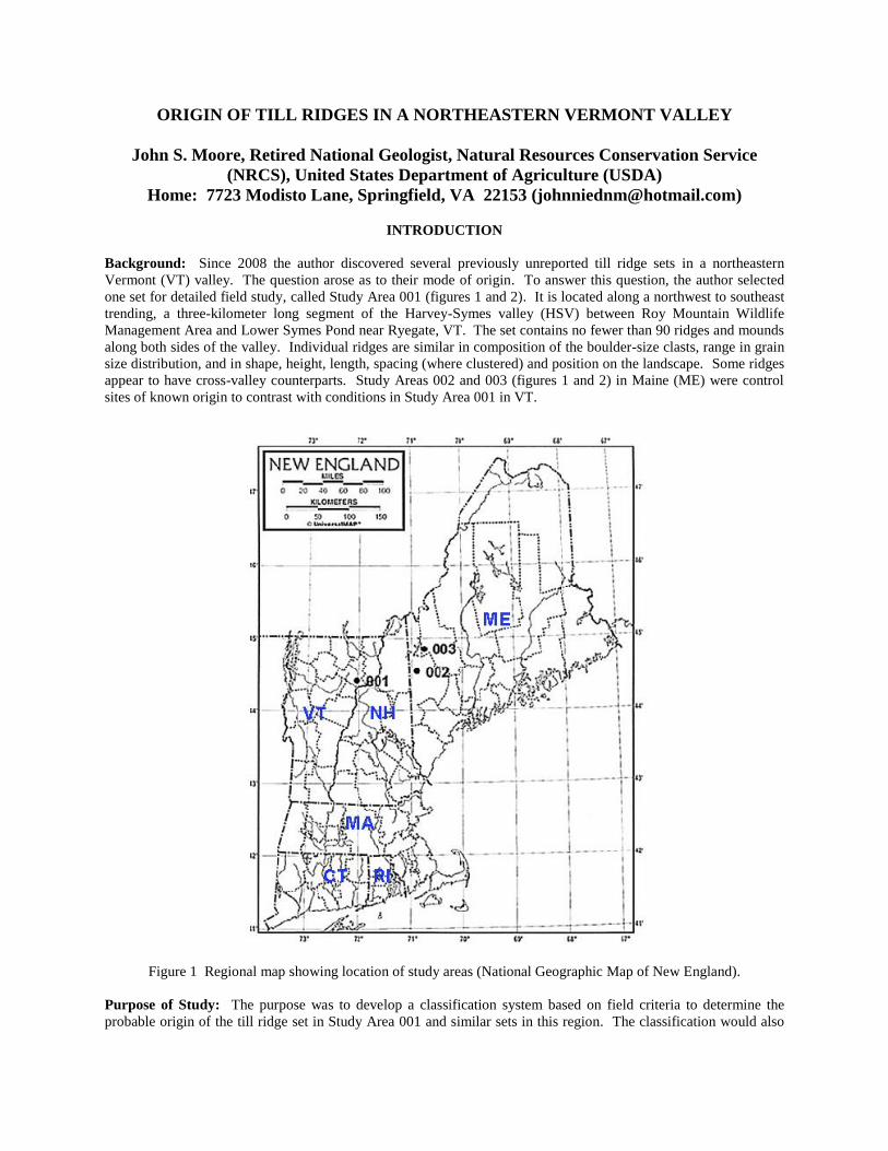
one set for detailed field study, called Study Area 001 (figures 1 and 2). It is located along a northwest to southeast
trending, a three-kilometer long segment of the Harvey-Symes valley (HSV) between Roy Mountain Wildlife
Management Area and Lower Symes Pond near Ryegate, VT. The set contains no fewer than 90 ridges and mounds
along both sides of the valley. Individual ridges are similar in composition of the boulder-size clasts, range in grain
size distribution, and in shape, height, length, spacing (where clustered) and position on the landscape. Some ridges
appear to have cross-valley counterparts. Study Areas 002 and 003 (figures 1 and 2) in Maine (ME) were control
sites of known origin to contrast with conditions in Study Area 001 in VT.
Figure 1 Regional map showing location of study areas (National Geographic Map of New England).
Purpose of Study: The purpose was to develop a classification system based on field criteria to determine the
probable origin of the till ridge set in Study Area 001 and similar sets in this region. The classification would also
serve to improve reconstruction of late glacial history and post-glacial geomorphic events in northern New England,
and may contribute to the understanding of global climate changes.
During fieldwork, the author considered two diametrically opposed hypotheses, erosion versus deposition. One
hypothesis contends the ridges in a given set are interfluves formed by erosion, specifically, post-glacial dissection
of a hillside till sheet by gullying and associated mass wasting processes. The other argues they are moraine ridges
or ice-marginal deposits formed by periodic deposition of detritus released near the receding margin of the
Laurentide Ice Sheet in New England. The author conducted two reconnaissance surveys in ME to serve as control
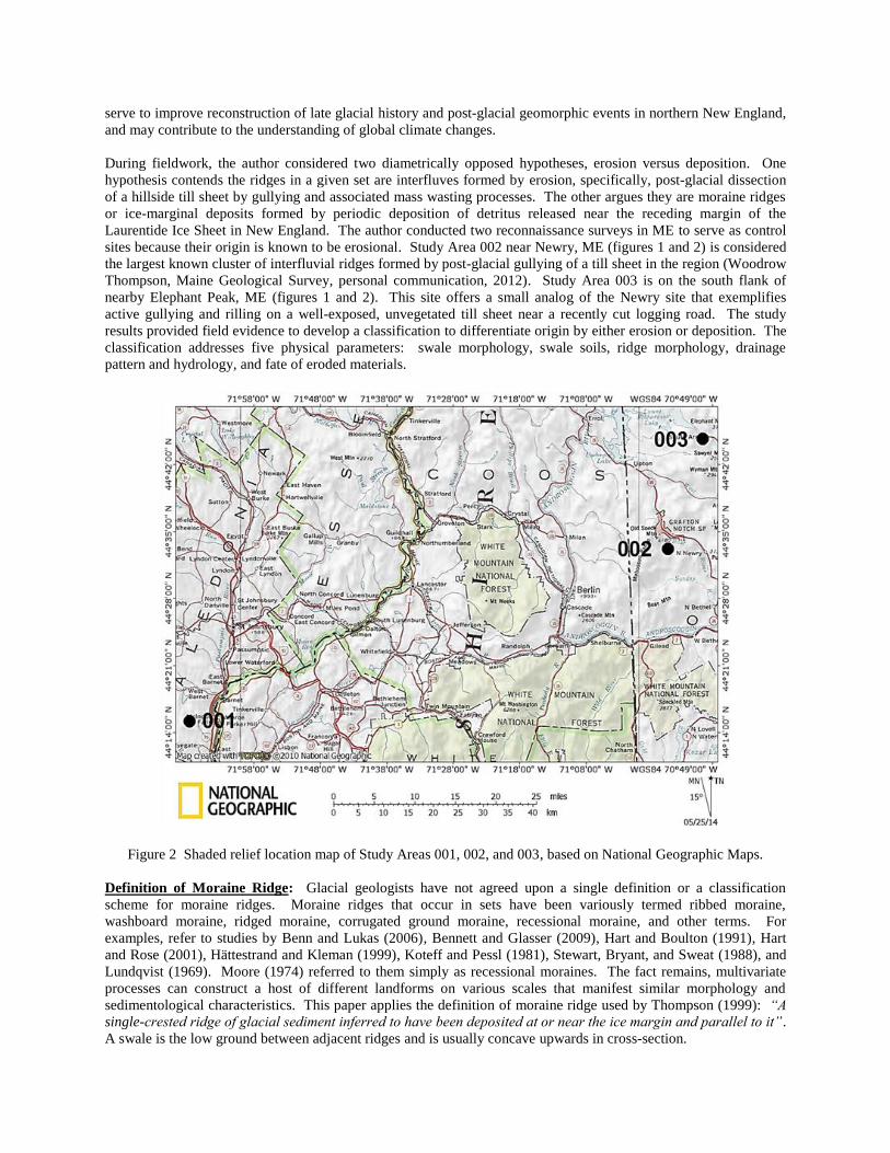
sites because their origin is known to be erosional. Study Area 002 near Newry, ME (figures 1 and 2) is considered
the largest known cluster of interfluvial ridges formed by post-glacial gullying of a till sheet in the region (Woodrow
Thompson, Maine Geological Survey, personal communication, 2012). Study Area 003 is on the south flank of
nearby Elephant Peak, ME (figures 1 and 2). This site offers a small analog of the Newry site that exemplifies
active gullying and rilling on a well-exposed, unvegetated till sheet near a recently cut logging road. The study
results provided field evidence to develop a classification to differentiate origin by either erosion or deposition. The
classification addresses five physical parameters: swale morphology, swale soils, ridge morphology, drainage
pattern and hydrology, and fate of eroded materials.
Figure 2 Shaded relief location map of Study Areas 001, 002, and 003, based on National Geographic Maps.
Definition of Moraine Ridge: Glacial geologists have not agreed upon a single definition or a classification
scheme for moraine ridges. Moraine ridges that occur in sets have been variously termed ribbed moraine,
washboard moraine, ridged moraine, corrugated ground moraine, recessional moraine, and other terms. For
examples, refer to studies by Benn and Lukas (2006), Bennett and Glasser (2009), Hart and Boulton (1991), Hart
and Rose (2001), Hättestrand and Kleman (1999), Koteff and Pessl (1981), Stewart, Bryant, and Sweat (1988), and
Lundqvist (1969). Moore (1974) referred to them simply as recessional moraines. The fact remains, multivariate
processes can construct a host of different landforms on various scales that manifest similar morphology and
sedimentological characteristics. This paper applies the definition of moraine ridge used by Thompson (1999): “A
single-crested ridge of glacial sediment inferred to have been deposited at or near the ice margin and parallel to it”.
A swale is the low ground between adjacent ridges and is usually concave upwards in cross-section.
Definition of Interfluvial Till Ridge: This paper defines an interfluvial ridge or the broader, flat and uneroded area
between adjacent gullies, as “The high ground separating adjacent gullies flowing in the same direction and which
were formed or are forming by fluvial and associated mass wasting processes that occur on the gully notch side
slopes” (Glossary of Geology, 1997). Interfluvial ridges tend to be oriented parallel with the fall line of the slope.
Gully erosion on a till sheet produces consequent, ephemeral or intermittent streams that tend to form a dendritic
drainage pattern.
Field Methods: Material and mass properties of soil and rock were described according standardized definitions of
terms and field practices given in Moore (2001a, and 2001b) and ASTM D2488, “Standard practice for description
and identification of soils (Visual-Manual Procedure)”, also called the Unified Soil Classification System (USCS).
Base maps are seamlessly joined, 7.5-minute, US Geological Survey (USGS) topographic quadrangles available
from the National Geographic’s commercial software for computer-assisted drawings. The software also was used
for track-recording and field navigation by a hand-held, Global Positioning System unit. Because some of the
USGS maps use metric units and others use English units for contour elevations (six meters or 20 feet) and scales
(kilometers and miles), both units are provided in the paper. Ridges that are less than six meters high are poorly
discernible on these maps. Small ridges and isolated masses were not mapped. Due to innate ground irregularities,
linear measurements were estimated by pacing and dead reckoning. The heights of features were measured by
altimeters or by dead reckoning.
FINDINGS
Study Area 001: The till ridge set in Study Area 001 is a portion of a larger complex of hundreds of ridges and
mounds that are mostly within the Roy Mountain Wildlife Management Area along the unnamed valley, herein
referred to as Harvey-Symes Valley (HSV) between W. Barnet and Ryegate, Caledonia County, VT (figures 2 and
3). The black rectangle in figure 3 encloses the four-kilometer square study area which the HSV bisects
longitudinally and follows the wet bottom. The northern margin of the study area is located at a valley bottom
divide blocked by thick, hummocky till that effectively redirects perennial flow of Jewett Brook north to Harveys
Lake. Streams south of the till divide flow into HSV to discharge into the Connecticut (CT) River at E. Ryegate,
VT. The southern limit of Study Area 001 is near Lower Symes Pond.
Subsequent area surveys on nearby hills outside of Study Area 001 revealed small till ridges that partially wrap
around upper sections of north facing hill slopes. These suggest nunatak formation and ice margin moraine
deposition by retreating active ice. These ridges and numerous others in the vicinity are still under field study and
are not shown on figure 3.
Numerous locally derived, angular to sub-rounded boulders up to 200 cubic meters in volume litter the surfaces of
ridges and inter-ridge areas. Ridge lengths vary between several tens of meters and 200 meters. Average crest
spacing on the both sides of HSV is approximately 60 meters. Ridge heights vary between three and 25 meters, but
most are between four and six meters. Ridges tend to be straight and oriented between 60° (pointed down-valley) to
perpendicular to the valley walls. The majority occur in declining fashion below the 318-meter (1040-foot) contour
elevation. Frontal and distal side slopes of most ridges range between 25° and 35° and are nearly symmetrical in
cross-section. Distal slopes are generally a few degrees steeper than frontal. Where angular, large boulders and
cobbles are abundant in the till, slopes range between 35° and 45°. These ranges are consistent with angles of
repose for unconsolidated, uncompacted, granular soils. Figures 5 and 6 illustrate a typical ridge in cross-section
and in profile, respectively. Field assessment tests of unconfined compressive strength of numerous till boulders
composed of foliated rock material ranged between 12.5 and 100 megapascals (MPa). Hammer blows perpendicular
to schistosity gave higher values than parallel with it. Granite, gneiss, and quartzite boulders had values between
100 and 250 MPa. Angularity of edges and planar faces of large clasts were between sub-angular and sub-rounded,
with sub-angular dominating. Large clasts showed no signs of weathering other than superficial iron oxide staining.
Grain-size gradation in till is variable from place to place and tends to be gap-graded. It consists of a coarse fraction
(≥ 3.0 inches) of cobbles through extremely large boulders that account for up to 80 % of till volume. The matrix
varies between 10 and 25 % micaceous, fine sandy silt (ML), silty fine sand (SM), and non-plastic silt (ML). The
clay fraction is low, ranging between 0 and 10 %. The gap accounts for less than 10 % of the till and consists of
material between the coarse sand and coarse gravel range (approximately 10 to 40 millimeters).
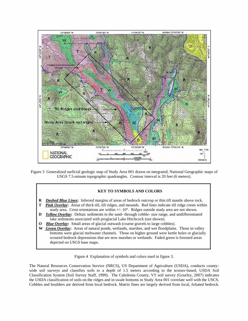
Figure 3 Generalized surficial geologic map of Study Area 001 drawn on integrated, National Geographic maps of
USGS 7.5-minute topographic quadrangles. Contour interval is 20 feet (6 meters).
KEY TO SYMBOLS AND COLORS
R Dashed Blue Lines: Inferred margins of areas of bedrock outcrop or thin till mantle above rock.
T Pink Overlay: Areas of thick till, till ridges, and mounds. Red lines indicate till ridge crests within
study area. Crest orientations are within +/- 10°. Ridges outside study area are not shown.
D Yellow Overlay: Deltaic sediments in the sand- through cobble- size range, and undifferentiated
lake sediments associated with proglacial Lake Hitchcock (not shown).
O Blue Overlay: Small areas of glacial outwash (coarse gravels to large cobbles).
W Green Overlay: Areas of natural ponds, wetlands, marshes, and wet floodplains. Those in valley
bottoms were glacial meltwater channels. Those on higher ground were kettle holes or glacially
scoured bedrock depressions that are now marshes or wetlands. Faded green is forested areas
depicted on USGS base maps.
Figure 4 Explanation of symbols and colors used in figure 3.
The Natural Resources Conservation Service (NRCS), US Department of Agriculture (USDA), conducts county-
wide soil surveys and classifies soils to a depth of 1.5 meters according to the texture-based, USDA Soil
Classification System (Soil Survey Staff, 1999). The Caledonia County, VT soil survey (Gourley, 2007) indicates
the USDA classification of soils on the ridges and in swale bottoms in Study Area 001 correlate well with the USCS.
Cobbles and boulders are derived from local bedrock. Matrix fines are largely derived from local, foliated bedrock.
The material strength of foliated bedrock is inherently low and thus afforded little resistance to glacial erosion,
abrasion, and percussion. Therefore, the rock readily disintegrated into non-plastic, fine particles.
In Study Area 001, swale drainage areas vary from a fraction of a hectare to approximately 10 hectares. There is no
alluvium in the swale bottoms. They are perennially wet due to thin, poorly drained soils and organic-rich muck that
cover dense till. Swales support denser and more water-tolerant ground vegetation than ridge sides and tops. Most
swales have an ephemeral or intermittent stream channel that carries runoff from the nearby hills or from small,
rock-fracture springs. Between rainfalls or during dry spells, intermittent stream channels are recharged by connate
water seepage along the bases of till ridges. For example, after one flow event, a channel at the head of a swale was
flowing one liter per minute. At its lower end, the stream was flowing five liters per minute. If clean, permeable
alluvium were to occur in a swale bottom, stream discharge would decrease downstream due to infiltration into the
alluvium. To check for Holocene alluvium, the author dug into 17 swales with a hand pick and never encountered
fluvial sediment. In every case, bottom material consisted of a veneer of wet, organic-rich, silty muck overlying
dense, slowly permeable till. Near surface water in swales is perched above and within poorly drained till and silty
muck.
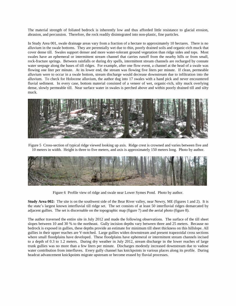
Figure 5 Cross-section of typical ridge viewed looking up axis. Ridge crest is crowned and varies between five and
10 meters in width. Height is three to five meters, and axis is approximately 150 meters long. Photo by author.
Figure 6 Profile view of ridge and swale near Lower Symes Pond. Photo by author.
Study Area 002: The site is on the southwest side of the Bear River valley, near Newry, ME (figures 1 and 2). It is
the state’s largest known interfluvial till ridge set. The set consists of at least 50 interfluvial ridges demarcated by
adjacent gullies. The set is discernable on the topographic map (figure 7) and the aerial photo (figure 8).
The author traversed the entire site in July 2012 and made the following observations. The surface of the till sheet
slopes between 10 and 30 % to the northeast. Gully incision depths vary between three and 25 meters. Because no
bedrock is exposed in gullies, these depths provide an estimate for minimum till sheet thickness on this hillslope. All
gullies in their upper reaches are V-notched. Large gullies widen downstream and present trapezoidal cross sections
where small floodplains have developed. These floodplains have ephemeral or intermittent stream channels incised
to a depth of 0.3 to 1.2 meters. During dry weather in July 2012, stream discharge in the lower reaches of large
trunk gullies was no more than a few liters per minute. Discharges modestly increased downstream due to vadose
water contribution from interfluves. Every gully channel has knickpoints in various places along its profile. During
headcut advancement knickpoints migrate upstream or become erased by fluvial processes.
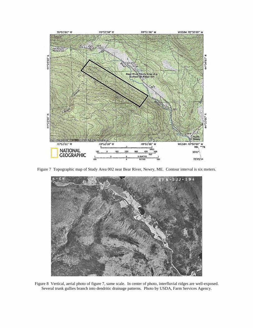
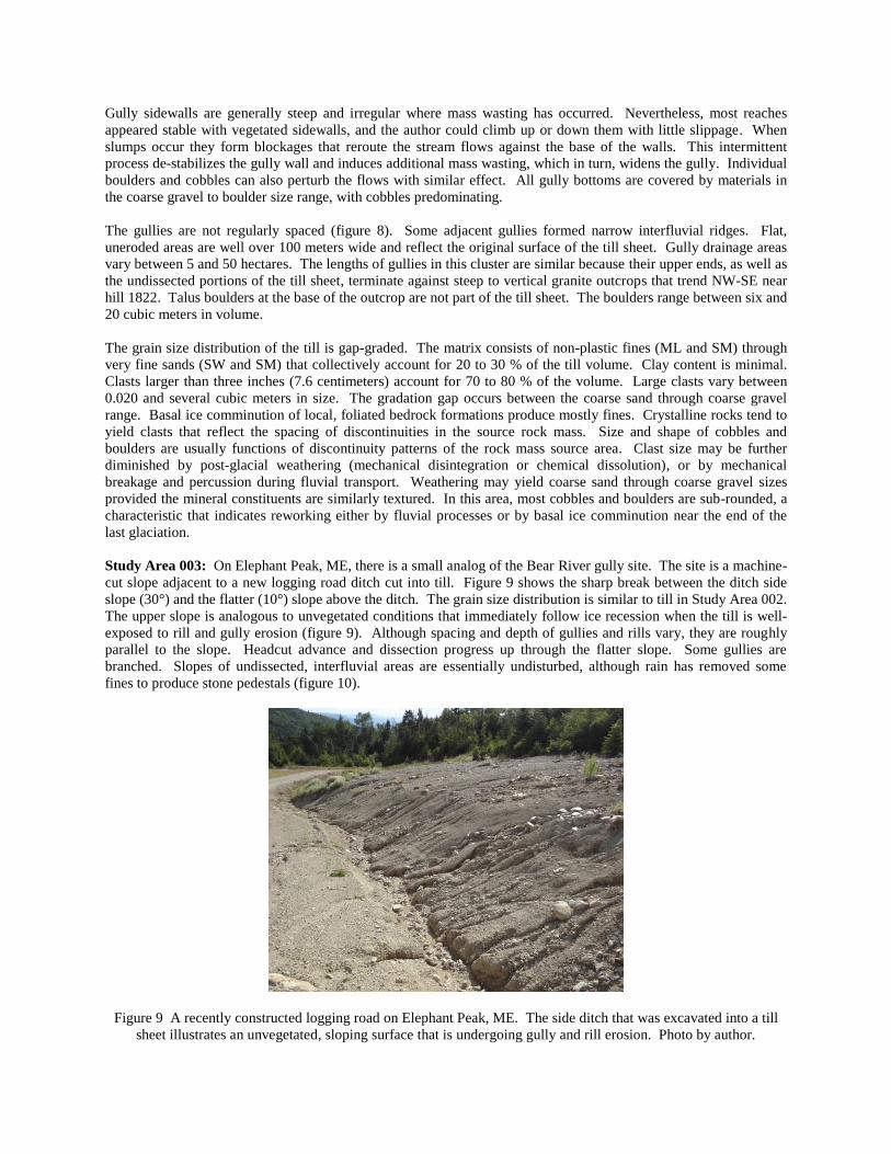
Figure 7 Topographic map of Study Area 002 near Bear River, Newry, ME. Contour interval is six meters.
Figure 8 Vertical, aerial photo of figure 7, same scale. In center of photo, interfluvial ridges are well-exposed.
Several trunk gullies branch into dendritic drainage patterns. Photo by USDA, Farm Services Agency.
Gully sidewalls are generally steep and irregular where mass wasting has occurred. Nevertheless, most reaches
appeared stable with vegetated sidewalls, and the author could climb up or down them with little slippage. When
slumps occur they form blockages that reroute the stream flows against the base of the walls. This intermittent
process de-stabilizes the gully wall and induces additional mass wasting, which in turn, widens the gully. Individual
boulders and cobbles can also perturb the flows with similar effect. All gully bottoms are covered by materials in
the coarse gravel to boulder size range, with cobbles predominating.
The gullies are not regularly spaced (figure 8). Some adjacent gullies formed narrow interfluvial ridges. Flat,
uneroded areas are well over 100 meters wide and reflect the original surface of the till sheet. Gully drainage areas
vary between 5 and 50 hectares. The lengths of gullies in this cluster are similar because their upper ends, as well as
the undissected portions of the till sheet, terminate against steep to vertical granite outcrops that trend NW-SE near
hill 1822. Talus boulders at the base of the outcrop are not part of the till sheet. The boulders range between six and
20 cubic meters in volume.
The grain size distribution of the till is gap-graded. The matrix consists of non-plastic fines (ML and SM) through
very fine sands (SW and SM) that collectively account for 20 to 30 % of the till volume. Clay content is minimal.
Clasts larger than three inches (7.6 centimeters) account for 70 to 80 % of the volume. Large clasts vary between
0.020 and several cubic meters in size. The gradation gap occurs between the coarse sand through coarse gravel
range. Basal ice comminution of local, foliated bedrock formations produce mostly fines. Crystalline rocks tend to
yield clasts that reflect the spacing of discontinuities in the source rock mass. Size and shape of cobbles and
boulders are usually functions of discontinuity patterns of the rock mass source area. Clast size may be further
diminished by post-glacial weathering (mechanical disintegration or chemical dissolution), or by mechanical
breakage and percussion during fluvial transport. Weathering may yield coarse sand through coarse gravel sizes
provided the mineral constituents are similarly textured. In this area, most cobbles and boulders are sub-rounded, a
characteristic that indicates reworking either by fluvial processes or by basal ice comminution near the end of the
last glaciation.
Study Area 003: On Elephant Peak, ME, there is a small analog of the Bear River gully site. The site is a machine-
cut slope adjacent to a new logging road ditch cut into till. Figure 9 shows the sharp break between the ditch side
slope (30°) and the flatter (10°) slope above the ditch. The grain size distribution is similar to till in Study Area 002.
The upper slope is analogous to unvegetated conditions that immediately follow ice recession when the till is well-
exposed to rill and gully erosion (figure 9). Although spacing and depth of gullies and rills vary, they are roughly
parallel to the slope. Headcut advance and dissection progress up through the flatter slope. Some gullies are
branched. Slopes of undissected, interfluvial areas are essentially undisturbed, although rain has removed some
fines to produce stone pedestals (figure 10).
Figure 9 A recently constructed logging road on Elephant Peak, ME. The side ditch that was excavated into a till
sheet illustrates an unvegetated, sloping surface that is undergoing gully and rill erosion. Photo by author.
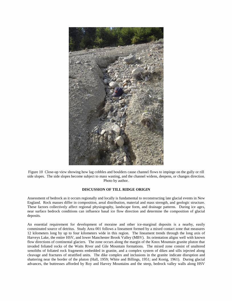
Figure 10 Close-up view showing how lag cobbles and boulders cause channel flows to impinge on the gully or rill
side slopes. The side slopes become subject to mass wasting, and the channel widens, deepens, or changes direction.
Photo by author.
DISCUSSION OF TILL RIDGE ORIGIN
Assessment of bedrock as it occurs regionally and locally is fundamental to reconstructing late glacial events in New
England. Rock masses differ in composition, areal distribution, material and mass strength, and geologic structure.
These factors collectively affect regional physiography, landscape form, and drainage patterns. During ice ages,
near surface bedrock conditions can influence basal ice flow direction and determine the composition of glacial
deposits.
An essential requirement for development of moraine and other ice-marginal deposits is a nearby, easily
comminuted source of detritus. Study Area 001 follows a lineament formed by a mixed contact zone that measures
12 kilometers long by up to four kilometers wide in this region. The lineament trends through the long axis of
Harveys Lake, the entire HSV, and lower Manchester Brook Valley (MBV). Its orientation aligns well with known
flow directions of continental glaciers. The zone occurs along the margin of the Knox Mountain granite pluton that
invaded foliated rocks of the Waits River and Gile Mountain formations. The mixed zone consist of unaltered
xenoliths of foliated rock fragments embedded in granite, and a complex system of dikes and sills injected along
cleavage and fractures of stratified units. The dike complex and inclusions in the granite indicate disruption and
shattering near the border of the pluton (Hall, 1959; White and Billings, 1951; and Konig, 1961). During glacial
advances, the buttresses afforded by Roy and Harvey Mountains and the steep, bedrock valley walls along HSV
steered basal ice south and southeast toward the Connecticut River valley. During recession, the outlet valley
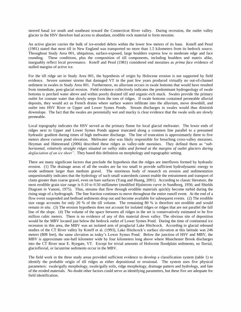
glacier in the HSV therefore had access to abundant, erodible rock material to form moraine.
An active glacier carries the bulk of ice-eroded debris within the lower few meters of its base. Koteff and Pessl
(1981) stated that most till in New England was transported no more than 1.5 kilometers from its bedrock source.
Throughout Study Area 001, ubiquitous, surface-exposed, large boulders express low to moderate edge and face
rounding. These conditions, plus the composition of till components, including boulders and matrix alike,
inarguably reflect local provenance. Koteff and Pessl (1981) considered end moraines as prima face evidence of
stalled margins of active ice.
For the till ridge set in Study Area 001, the hypothesis of origin by Holocene erosion is not supported by field
evidence. Severe summer storms that damaged VT in the past few years produced virtually no out-of-channel
sediment in swales in Study Area 001. Furthermore, no alluvium occurs in swale bottoms that would have resulted
from immediate, post-glacial erosion. Field evidence collectively indicates the predominant hydrogeology of swale
bottoms is perched water above and within poorly drained till and organic-rich muck. Swales provide the primary
outlet for connate water that slowly seeps from the toes of ridges. If swale bottoms contained permeable alluvial
deposits, they would act as French drains where surface waters infiltrate into the alluvium, move downhill, and
outlet into HSV River or Upper and Lower Symes Ponds. Stream discharges in swales would thus diminish
downslope. The fact that the swales are perennially wet and mucky is clear evidence that the swale soils are slowly
permeable.
Local topography indicates the HSV served as the primary flume for local glacial meltwater. The lower ends of
ridges next to Upper and Lower Symes Ponds appear truncated along a common line parallel to a presumed
hydraulic gradient during times of high meltwater discharge. The line of truncation is approximately three to five
meters above current pond elevation. Meltwater also was likely responsible for breaching cross-valley moraines.
Heyman and Hättestrand (2006) described these ridges as valley-side moraines. They defined them as “sub-
horizontal, relatively straight ridges situated on valley sides and formed at the margins of outlet glaciers during
deglaciation of an ice sheet”. They based this definition on morphology and topographic setting.
There are many significant factors that preclude the hypothesis that the ridges are interfluves formed by hydraulic
erosion. (1) The drainage areas of all the swales are far too small to provide sufficient hydrodynamic energy to
erode sediment larger than medium gravel. The enormous body of research on erosion and sedimentation
unquestionably indicates that the hydrology of such small watersheds cannot enable the entrainment and transport of
clasts greater than coarse gravel, even on bare surfaces (Yang and Huang, 2001). According to classic literature, the
most erodible grain size range is 0.10 to 0.50 millimeter (modified Hjulstrom curve in Sundborg, 1956; and Shields
Diagram in Vanoni, 1975). Thus, streams that flow through erodible materials quickly become turbid during the
rising stage of a hydrograph. The fine fraction continues to move throughout the entire runoff event. At the end of a
flow event suspended and bedload sediments drop out and become available for subsequent events. (2) The erodible
size range accounts for only 20 % of the till volume. The remaining 80 % is therefore not erodible and would
remain in situ. (3) The erosion hypothesis does not account for isolated ridges or ridges that are not parallel the fall
line of the slope. (4) The volume of the space between all ridges in the set is conservatively estimated to be five
million cubic meters. There is no evidence of any of this material down valley. The obvious site of deposition
would be the MBV located just below the bedrock outlet of Lower Symes Pond. During the time of continental ice
recession in this area, the MBV was an isolated arm of proglacial Lake Hitchcock. According to glacial rebound
studies of the CT River valley by Koteff et al. (1993), Lake Hitchcock’s surface elevation at this latitude was 246
meters (808 feet), the same elevation as today’s Lower Symes Pond. Below the junction of HSV and MBV, the
MBV is approximate one-half kilometer wide by four kilometers long above where Manchester Brook discharges
into the CT River near E. Ryegate, VT. Except for trivial amounts of Holocene floodplain sediments, no fluvial,
glaciofluvial, or lacustrine sediments occur in the MBV.
The field work in the three study areas provided sufficient evidence to develop a classification system (table 1) to
identify the probable origin of till ridges as either depositional or erosional. The system uses five physical
parameters: swale/gully morphology, swale/gully soils, ridge morphology, drainage pattern and hydrology, and fate
of the eroded materials. No doubt other factors could serve as identifying parameters, but these five are adequate for
field identification.
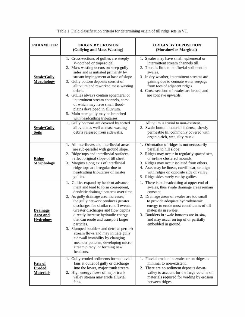
Table 1 Field classification criteria for determining origin of till ridge sets in VT.
PARAMETER
ORIGIN BY EROSION
(Gullying and Mass Wasting)
ORIGIN BY DEPOSITION
(Moraine/Ice-Marginal)
Swale/Gully
Morphology
1. Cross-sections of gullies are steeply
V-notched or trapezoidal.
2. Mass wasting occurs on steep gully
sides and is initiated primarily by
stream impingement at base of slope.
3. Gully bottom deposits consist of
alluvium and reworked mass wasting
debris.
4. Gullies always contain ephemeral or
intermittent stream channels, some
of which may have small flood-
plains developed in alluvium.
5. Main stem gully may be branched
with headcutting tributaries.
1. Swales may have small, ephemeral or
intermittent stream channels till.
2. There is little to no fluvial sediment in
swales.
3. In dry weather, intermittent streams are
gaining due to connate water seepage
from toes of adjacent ridges.
4. Cross-sections of swales are broad, and
are concave upwards.
Swale/Gully
Soils
1. Gully bottoms are covered by sorted
alluvium as well as mass wasting
debris released from sidewalls.
1. Alluvium is trivial to non-existent.
2. Swale bottom material is dense, slowly
permeable till commonly covered with
organic-rich, wet, silty muck.
Ridge
Morphology
1. All interfluves and interfluvial areas
are sub-parallel with ground slope.
2. Ridge tops and interfluvial surfaces
reflect original slope of till sheet.
3. Margins along axis of interfluvial
ridge tops are irregular due to
headcutting tributaries of master
gullies.
1. Orientation of ridges is not necessarily
parallel to hill slope.
2. Ridges may occur in regularly spaced sets,
or in-line clustered mounds.
3. Ridges may occur isolated from others.
4. Axes may be linear, curvilinear, or align
with ridges on opposite side of valley.
5. Ridge sides rarely cut by gullies.
Drainage
Area and
Hydrology
1. Gullies expand by headcut advance-
ment and tend to form consequent,
dendritic drainage patterns over time.
2. As gully drainage area increases,
the gully network produces greater
discharges for similar runoff events.
Greater discharges and flow depths
directly increase hydraulic energy
that can erode and transport larger
particles.
3. Slumped boulders and detritus perturb
stream flows and may initiate gully
sidewall instability by changing
meander patterns, developing micro-
stream piracy, or forming new
headcuts.
1. There is no headcutting at upper end of
swales, thus swale drainage areas remain
constant.
2. Drainage areas of swales are too small
to provide adequate hydrodynamic
energy to erode most constituents of till
materials in swales.
3. Boulders in swale bottoms are in-situ,
and may occur on top of or partially
embedded in ground.
Fate of
Eroded
Materials
1. Gully-eroded sediments form alluvial
fans at outlet of gully or discharge
into the lower, major trunk stream.
2. High energy flows of major trunk
valley stream may erode alluvial
fans.
1. Fluvial erosion in swales or on ridges is
minimal to non-existent.
2. There are no sediment deposits down-
valley to account for the large volume of
materials required for voiding by erosion
between ridges.
CONCLUSIONS
The author conducted on-ground reconnaissance surveys of surficial deposits in Northeastern VT between 2008 and
2014 and encountered several till ridge sets along some valley slopes. The question arose as to the origin of these
ridges. One 90-ridge set (Study Area 001) was evaluated to address two diametrically opposed hypotheses for ridge
origin. One hypothesis contends the ridges in a given set are interfluves formed by erosion, specifically by
Holocene gullying and associated mass wasting processes that dissect a hillside till sheet. The other hypothesis
argues they are moraine ridges or ice-marginal deposits formed by periodic deposition of detritus released near the
receding margin of the Laurentide ice sheet in New England. Two ridge sets in ME (Study Areas 002 and 003) were
selected as control sites because they are clearly interfluvial ridges formed by erosion. Diagnostic field evidence
gleaned from these two sites was contrasted with the VT set’s physical characteristics.
The body of field evidence demonstrably supports the hypothesis that the VT till ridge set was formed as recessional
moraines deposited by active, receding ice in the HSV during waning phases of the Laurentide ice sheet in this part
New England. The following facts support this conclusion. (1) All swale drainage areas in Study Area 001 are far
too small to generate streams with sufficient hydraulic energy to entrain and transport sediment larger than medium-
sized gravel (approximately 10 to 40 millimeters). Given that up to 80 % of the local till consists of material greater
than coarse gravel size, it is impossible for hydraulic erosion to create the inter-ridge voids. (2) There are no lag
deposits or alluvial sediments in the swale bottoms to indicate that erosion processes have occurred. (3) If streams
were competent to erode and transport all available grain sizes and in the volumes represented by inter-ridge voids,
the question arises as to the fate of this material. The most logical sediment trap would have been the MBV just
below the HSV, yet there is no appreciable sediment to be found. In fact, thorough field checking between the HSV
and the CT River valley did not reveal any meaningful volumes of alluvial fan, stream alluvium, or lacustrine
deposits (associated with proglacial Lake Hitchcock) to account for the material. (4) Cross sections of swales and
ridges are gently rounded, concave and convex, respectively. These configurations are not consistent with small-
scale valley development formed by stream erosion and concomitant mass wasting (Bloom, 1969). (5) In obvious
contrast, cross-sections of gullies and interfluves in Study Areas 002 and 003 are more sharply defined than swales
in Study Area 001. Gullies are V-notched where narrow, and trapezoidal in the downstream, wider reaches.
Drainage patterns are sub-dendritic formed by consequent gullies that advanced by headcutting into a till sheet. (6)
In Study Areas 002 and 003, the occurrence of gully bottom alluvium and evidence of mass wasting on gully
sidewalls obviously indicate the interfluvial ridges formed by classic gully erosion.
Observations at the three study areas led to the development of a classification system to differentiate the two modes
of till ridge origin. The classification uses five physical parameters: swale/gully morphology, swale/gully soils,
ridge morphology, drainage pattern and hydrology, and fate of the eroded materials. Each parameter is identified by
criteria to support each mode of origin. The field classification system will readily assist the field worker in
determining the origin of till ridges by either erosional or depositional processes. When higher resolution imagery,
such as Lidar, becomes more widely available, more glacial features undoubtedly will be discovered that cannot be
discerned on USGS topographic quadrangle maps. Because the origin of newly discovered features should be
ground-truthed, it is hoped the classification will serve to improve reconstruction of late glacial history and post-
glacial geomorphic events in northeastern VT and in other similar regions.
ACKNOWLEDGMENTS
I thank David G. Johnson for his interest, time, and stimulating discussions, and for providing numerous
constructive and thorough peer reviews of the manuscript. David accompanied me in the field on many occasions
and offered a wealth of valuable ideas and useful critique throughout this study. I appreciate Jeffrey Noyes for his
helpful discussions and ideas. I thank my wife Christine Moore for her critical editorial review of the manuscript. I
thank Claudia Hoeft for providing substantive, editorial and technical review of the final manuscript.
REFERENCES
ASTM Standard D2488. (2009). Standard practice for description and identification of soils (Visual-Manual
Procedure). ASTM International, West Conshohocken, PA 19428.
Bennett, M.R., and Glasser, N.F. (2009). Glacial Geology: Ice Sheets and Landforms. Second edition, Wiley-
Blackwell, 385 p.
Bloom, A.L. (1969). The Surface of the Earth. Foundations of Earth Science Series. Prentice-Hall, 152 p.
Doll, C.G. (compiler and editor). (1970). Surficial geologic map of VT, scale 1:250,000, Geology by D.P. Stewart,
and MacClintock, P.. VT Geol. Surv., Waterbury, VT 05671-2420.
Gourley, S.H. (2007). Soil Survey of Caledonia County, VT. NRCS, USDA, Burlington, VT 05401.
Hall, L.M. (1959). Geology of St. Johnsbury Quad, (15-min.), VT and NH. VT Geol. Surv. Bull. 13, 105 p.
Hart, R., and Boulton, G.S. (1991). Interrelationship between glaciotectonic deformation and glaciodeposition.
Quaternary Science Reviews, vol. 10, pp. 335-350.
Hart, R., and Rose, J. (2001). Approaches to the study of glacial bed deformation. Quat. Intl., vol. 86, pp. 45-58.
Hättestrand, C., and Kleman, J. (1999). Ribbed moraine formation. Quat. Sci. Rev., vol. 18, pp. 43-61.
Homer, J.W. (1999). Soil Survey of Grafton Co. Area, NH. NRCS, USDA, in cooperation with UNH, Agricultural
Experiment Station.
Jackson, J.A. (editor) (1997). Glossary of Geology, Fourth edition. American Geological Institute, Alexandria, VA
22302.
Koteff, C., and Pessl, F. (1981). Systematic ice retreat in New England. USGS Prof. Paper 1179, 20 p.
Koteff, C., Robinson, G.R., Goldsmith, R., and Thompson, W.B. (1993). Delayed postglacial uplift and synglacial
sea levels in coastal central New England. Quaternary Research, vol. 40, p. 46-54.
Konig, R.H. (1961). Geology of the Plainfield 15-min. Quad (15-min.), VT. VT Geol. Surv. Bull. 16, 86 p.
Lundqvist, J. (1969). Problems of the so-called Rogen moraine. Sverges Geologiska Undersökning C, 648, 32 p.
Moore, J.S. (1974). Origin and geolimnology of Joes Pond, VT. Unpublished MS thesis, Dept. Geol., UVM, 80 p.
Moore. (2001a, revised). Field procedures guide for the headcut erodibility index. NEH-628-52, NRCS, USDA,
Washington, DC 20013, 31 p.
Moore. (2001b). Rock material field classification system. NEH-12-631, Geology. NRCS, USDA, Washington,
D.C. 20013, 12 p.
Soil Survey Staff. (1999). Soil taxonomy: A basic system of soil classification for making and interpreting soil
surveys. Second ed. Natural Resources Conservation Service. U.S. Department of Agriculture Handbook 436.
Stewart, D.P. and MacClintock, P. (1969). Surficial geology and Pleistocene history of VT. VT Geol. Surv. Bull.
31, 251 p.
Stewart, R.A., Bryant, D., and Sweat, M.J. (1988). Nature and origin of corrugated ground moraine of the Des
Moines lobe, Story County, IA. Geomorphology, vol. 1, issue 2, pp. 111-130.
Thompson W.B. (1999). History of research on glaciation in the White Mountains, NH. Geographie Physique et
Quaternaire, vol. 53 (1), pp. 7-24.
White, W.S., and Billings, M.P. (1951). Geology of Woodsville Quad (15-min.), VT – NH. Bull. Geol. Soc. Am.,
vol. 62, pp. 647-696.