Embed Size (px)
Citation preview
ORIGINAL
AGREEMENT BETWEEN THE CITY OF STILLWATER AND THE TOWN OF STILLWATER FOR GROWTH MANAGEMENT, ORDERLY ANNEXATION AND THE EXERCISE OF JOINT POWERS
FOR PLANNING AND LAND USE CONTROL
THIS AGReEMENT is made this / b a day o f hb& , 1996, ("Effective Date") between the City of Stillwater, Washington County, Minne ta ("City") and the Town of Stillwater, Washington County, Minnesota ("Town") and is an agreement relating to growth management and constitutes a "Joint Resolution" between the City and Town authorized by Minnesota Statutes $414.0325 providing for a procedure and a framework for orderly annexation of a part of the Town to the City. This Agreement also provides for the joint exercise by the City and Town of their respective planning and land use control
. . authority pursuant to Minn. Stat. 471!59 and Minn. Stat. 414.0325 (Subd. 5).
SECTION ONE INTRODUCTION
1.01 Certain land owners within the Town have petitioned the City for annexation and for the extension of municipal utilities. Since receiving the petition, the City has undertaken a review of its Comprehensive Plan and has studied the ability of the City to provide services to the area and has concluded that if the area requesting services' is developed into urban uses the City would ultimately be benefited by a broadened tax base and a more vital community and that urban growth in the annexation area would benefit the City. The Town has participated in a review of the City's Comprehensive Plan and has concluded that it would be beneficial to the Town, and to property owners remaining in the Town after annexation, to enter this Agreement with the City so that the area to be annexed will be developed in an orderly fashion and with the least possible impact on the people of the Town.
INTENT
The parties to this agreement intend it to be binding with all the rights, privileges, and obligations attached thereto. Both parties intend to be bound by this agreement and shall not violate its terms. Neither party shall exercise any legislative authority either now existing or which may be later created in a way which violates the terms of the agreement. Both parties understand that they may not limit the power of the legislature over annexation, and such is not their intent. Instead, the parties agree to refrain from exercising any legislative authority, now or into the future, in a way that would violate the terms of this agreement.
INCLUSION INTO COMPREHENSIVE PLAN
1.03 Within sixty (60) days of the City's adoption of this Joint Resolution, the City shall adopt and forward to the Metropolitan Council a Comprehensive Plan Arhendment incorporating the Orderly Annexation Agreement into the City's Comprehensive Plan.
SECTION TWO ORDERLY ANNEXATION AREA
2.01 The property described in Exhibit "A" that is subject to annexation by the City pursuant to this Agreement will constitute the "Orderly Annexation Area". This area includes all that area of the Town not now within the City that lies North of Highway 36, East of County Road 15 and South of Highway 96, except for that portion of the Town that lies North of the right-of-way of the Minnesota Zephyr Track and East of the Oak Glen development. The Orderly Annexation Area is designated as in need of orderly annexation and no consideration by the Minnesota Municipal Board is necessary, no alteration of the boundaries is appropriate, and all conditions of annexation have been provided for in this Resolution and the Minnesota Municipal Board may review and comment only and within thirty (30) days of receipt of this Resolution and each subsequent phase as described in this Agreement upon the filing of a Resolution as described in this Agreement.
SECTION THREE PHASING SCHEDULE
3.01 The Town and City agree that phasing the growth envisioned for the annexation area would benefit the City by reducing the fmancial risk of extending core facilities into the Orderly Annexation Area by extending such facilities gradually rather than at one time. This would also allow for the burden imposed by the growth to be gradually born by the City so that the level of services needed by the new development could be supplied on a gradual and phased basis. The Town has agreed that a phased development plan as envisioned by this Agreement would benefit the Town by phasing the impact of lost tax base on the remaining Town government and easing fmancial and lifestyle burdens that an immediate annexation of the entire area would impose on Town residents. For the purposes of this Agreement, the Orderly Annexation Area will be divided into four (4) phases described as follows:
Phase I Description
3.02 Phase I contains that property described in Exhibit "B", generally described as that part of the Town that is South of County Road 12, East of County Road 15 and North of Highway 36, except for the following property that will remain as Phase IV property unless Annexation is requested by the property owner pursuant to Section 4.08 herein:
a. The Bergman Farm, 1205 - 60th Street North Parcel Numbers 31-030-20-32-0001 and 31-030-20-34-0001 Owners: Alvin and Helen Bergman
b. 1223 - 62nd Street North Parcel Number 3 1-030-20-34-0002 Owner: Paul Bergman
c. 7143 Manning Avenue Parcel Number 30-030-20-33-0001 Owners: Robert M. and Ann S. Jordan
d. 7135 Manning Avenue Parcel Number 30-030-20-33-0002 Owners: Ralph E. and Kimberly A. Stowell
e. 6731 Manning Avenue Parcel Number 31-030-20-23-0001 Owner: Rosalie Gadient
The Phase I also includes the Stillwater Golf Course. The approximate population of the Phase I area is
Phase I1 Description
3.03 The Phase I1 property is the property described in Exhibit "C" commonly referred to as the Abramowicz Farm property, Rivard property and Newman property.
Phase In Description
3.04 The Phase I11 property is the property described in Exhibit "D" and commonly referred to as the Palmer Farm property. This Agreement will not obligate the City to provide adjacency between the present City and the Palmer property and it will be the obligation of the Developer to provide adjacency before the Resolution on Phase I11 is enacted.
Phase IV Description
3.05 The Phase IV property is that portion of the Orderly Annexation Area that is not included in Phases I, 11 or 111.
SECTION FOUR TIMING OF ANNEXATION OF PHASES
4.01 Under no circumstances will the growth in the Orderly Annexation Area- exceed a cumulative total of 120 dwelling units per calendar year measured from the year 1996 as year one. This limitation shall apply to the issuance of building permits. The City shall provide a written report to the Joint Board on July 15 and January 15 of each year commencing in 1997 identifying the number and location of building permits for new residential dwelling units issued during the previous six months.
Phase I property will be annexed to the City after the execution of this Agreement. The Municipal Board shall order annexation of the Phase I property within thirty (30) days following receipt of this Joint Resolution.
Phase I1 property may be annexed by the City filing a Resolution with the Minnesota Municipal Board any time after January 1, 1999.
Phase 111 property may be annexed by the City filing a Resolution with the Minnesota Municipal Board any time after January 1, 2002.
Phase IV property may be annexed by the City filing a Resolution with the Minnesota Municipal Board any time after January 1, 2015.
The City may annex Phase I1 property prior to January 1, 1999 provided that the accelerated growth does not exceed the one hundred twenty (120) dwelling units per year limitation.
The City may annex Phase I11 property prior to January 1, 2002 provided that: a) the accelerated growth does not exceed the one hundred and twenty (120) dwelling units per year limitation; and b) that seventy-five percent (75%) of the net developable area of Phase I property annexed to the City has been platted and developed into occupied .residential dwellings.
The City is free to deny an annexation or extend the timing of a phase at any time at its sole discretion. This Agreement does not confer any rights upon any individual property owner to require the City to annex his or her property.
As an exception to the Phasing Schedule, the City may annex property not described in Phases I, I . or I11 by Resolution if the property is adjacent to the City, is petitioned for by one hundred percent (100%) of the property owners within the area to be annexed and if the resulting annexation will not create a level of growth that exceeds the one hundred twenty (120) dwelling units per year limitation.

SECTION FIVE COMMERCIAL, AND OTKER DEVELOPMENT
5 .O1 Commercial Development within the Annexation Area will be limited to'the 6.3 acres of commercial property at the southeast quadrant of C.S.A.H. 12 and C .S.A.H. 15, and the Bergman and Bradshaw property along Highway 36 between County Road 5 and County Road 15. These are the only properties designated for commercial use in the City's Comprehensive Plan.
5.02 Within sixty (60) days of the City's adoption of this Joint Resolution, the City will amend its Zoning Ordinance to include a separate zoning classification that will be described as "Village Commercial Zoning" or "Neighborhood Commercial" with separate guidelines, standards and design criteria designed to meld the 6.3 acre commercial area into the rural setting of the adjacent residential property remaining in the development and the Town as described in Exhibit "EM.
5.03 Within sixty (60) days of the City's adoption of this Joint Resolution, the City will amend its Zoning Ordinance to include a separate zoning classification for the Bergman and Bradshaw properties to be known as the "Research and Development District" that will have standards and criteria consistent with the classification described in the Comprehensive Plan. The district will house office, light industrial and service uses in a coordinated planned unit development campus setting.
5.04 Agriculture will continue to be a permitted use in the areas re-zoned pursuant to this Section.
SECTION SIX ASSESSMENT AND UTILITY POLICY
6.01 Concurrent with the adoption of this "Joint Resolution", the City Council will adopt an assessment policy that will protect new City property owners who are neither subdividing their property nor requesting municipal services from special assessments and utility charges for sanitary sewer, storm sewer, water and street upgrading. The policy shall be as follows:
a. Except as set forth in Section 6.04, no property will be assessed for sanitary sewer or required to pay sanitary sewer hook-up or utility charges if the property is not connected to public sanitary sewer.
b. Except as set forth in Section 6.04, no property will be assessed for municipal water or required to pay water hook-up or utility charges if the property is not connected to the municipal water system.
c. No property will be assessed for storm water improvements or required to pay storm water hook-up or utility charges prior to subdivision of the property.
d. Any property which hooks-up to City sanitary sewer shall pay a hook-up charge which will not exceed Twenty-Five Hundred Dollars ($2,500.00). The $2,500 limit shall be inclusive of all trunk or core facilities, laterals and other public costs associated with the installation of and hook-up to the system.
e. Any property which hooks-up to City municipal water system shall pay a hook-up charge which will not exceed Twenty-Five Hundred Dollars ($2,500.00). The $2,500 limit shall be inclusive of all trunk or core facilities, laterals and other public costs associated with the installation of and hook-up to the system.
f. Property which is not being subdivided will not be assessed for the cost of street improvements necessitated by development occurring within the orderly annexation area. However, if the street is substandard at the time of the improvement, the property may be assessed an amount equal to the assessment that would have been levied by the Town, if any, under the Town assessment policy in effect prior to the annexation of Phase One. The property may be subject to additional deferred assessments payable if and when the property is subdivided. "Substandard" is determined by Township standards in effect prior to the annexation of Phase I.
g. If a property hooks up to City sewer or water it will be charged for one hook- up as per Section 6.01 d and e regardless of whether the property can be further subdivided. Additional hook-up charges will be due at the time the property is subdivided based upon the hook-up charges in effect at that time.
6.02 Concurrent with the City's adoption of this "Joint Resolution", the City will adopt a sanitary sewer and water hook-up policy which includes the following provisions relating to property within the orderly annexation area:
a. Prior to subdivision of the property, no property owner will be required to hook-up to the City's municipal water system.
b. Prior to subdivision of the property, no property owner will be required to hook-up to the City's sanitary sewer system unless.hook-up is mandated by State Statute or Minnesota Pollution Control Agency (MPCA) regulation and enforcement action is initiated. A property owner will be permitted to upgrade or replace a failing system in accordance with MPCA standards. The City ordinance will not impose regulations that are more stringent than those required by the MPCA.
6.03 This section does not require the City, if requested to by a Property Owner, to extend sanitary sewer service to property which has a failed on-site system if the extension is not feasible or cost effective.
6.04 The benefits and limitations set forth in this Section do not apply nor are they for the benefit of owners who subdivide their property.
6.05 The limitations in Sections 6.01 d and e will be annually adjusted commencing January 1, 1997 based upon the Consumer Price Index for Urban Consumers (CP-U).
SECTION SEVEN REAL ESTATE TAXATION
7.01 Rural Tax Rate Adiustrnent. It is recognized that there is a significant difference between the City's municipal percent of tax capacity rate, which is approximately .35 percent for the calendar year 1996, and the Town's existing percent of tax capacity rate of .17 percent and that to require property that is brought into the City against the wishes of a property owner to pay the full municipal rate would be burdensome. The City, therefore, will concurrent with the City's adoption of this "Joint Resolution" amend, subject to the second reading required by City Charter, its Rural Service Taxing District Ordinance to include:
a. A rural service district that will include only parcels that are not c o ~ e c t e d to municipal sewer or water services.
b. A rural service tax rate that will be set at seventy-five percent (75%) of the City Urban Service District rate.
c. Pursuant to Minn. Stat. 414.035, for parcels that have not requested annexation, the initial rural service tax rate in the year of annexation will be Fifty percent (50%) of the urban rate, with the percentage being increased five percent (5%) each year to the seventy-five percent (75%) rural service rate.
7.02 Tax RateAdiustment for Parcels Not Requesting Annexation. Pursuant to Minn. Stat. 414.035, for parcels that have not requested annexation and do not qualify for the rural service taxing district, the initial urban tax rate in the year of annexation will be fifty percent (50%) of the urban rate, with the percentage being increased 10 percent (10%) each year for five (5) years to the full urban rate.
7.03 Tax Pavment to Town. During the term of this Agreement, taxes received by the City based upon the tax capacity generated from any area annexed in the year of annexation will be paid over to the Town and thereafter the amount to be paid to the Town will be reduced by twenty percent (20%) each year until the amount reaches zero (0), when taxes based upon the full tax capacity will remain with the City. For the purpose of this section, any increase in tax capacity over the tax capacity generated in the year of annexation will remain with the City.
7.04 Year of Annexation. If the annexation becomes effective on or before August 1 of any year, the City may levy on the annexed area beginning with that year. If the annexation becomes effective after August 1 of any year, the Town may contintie to levy on the annexed area for that year, and the City may not levy in the annexed area until the following year.
SECTION EIGHT JOINT PLANNING AND LAND USE CONTROL
8.01 The purpose of this section of the Agreement is to provide for the joint exercise of governmental authority by the City and Town pursuant to Minn. Stat, 471..59 and 414.0325, Subd. 5 in order to insure orderly development within the annexation area in accordance with this Orderly Annexation Agreement and the City's Comprehensive Plan.
8.02 The powers set forth herein shall be exercised by a four (4) member board consisting of two (2) City Council members appointed by the City and two (2) Town Board members appointed by the Town Board of Supervisors.
8.03 The Joint Board will review official controls necessary to regulate development of property and development applications within the Orderly Annexation Area before its annexation by the City in order to insure that the property remains in a status available for development into urban density residential uses in accordance with the City's Comprehensive Plan. The area north of the railroad tracks and east of the Oak Glen development and south of Highway 96 shall remain in the present conservency zoning classification now in effect in the area. A zoning classification for the Bergrnan farm that is the same as the City's Research and Development Zoning District will be adopted in order to protect the area from development that would prevent or frustrate the eventual urban development of the farm as an Urban Research and Development Center. Nothing in this subsection shall preclude the Town's approval of a subdivision of a parcel of land into three or fewer lots with a minimum lot size of 2.5 acres.
8.04 As to property within the Orderly Annexation Area after its annexation into the City, the Joint Board. shall have the following delegated powers':
a. Approve amendments to the City's Comprehensive Plan relating to the Orderly Annexation Area;
b. Approve the initial adoption of, amendments to, or variances from the City's official controls relating to the Orderly Annexation Area.
c. Approve any special assessment and sanitary sewer and water hook-up ordinance or policy and any amendments for consistency with Section Six.
d. Approve the Rural Service Taxing District ordinance or any amendments thereto, for consistency with Section Seven herein.
e. Review and comment on the consistency of any development application with City's Comprehensive Plan and Orderly Annexation Agreement.
f. All matters subject to approval by the Joint Board as set forth in 88.04 (a), (b) or (c) shall be processed in the same manner by the City as any other such
matter. Any required public hearing before the City Planning Commission or City Council shall also be noticed as a public hearing before the Joint Board.
g. Final action by the City relating to matters described in $8.04, Subd. (a), (b), (c) or (d) may not be taken unless the Joint Board certifies approval of the action. If the Joint Board fails to certify approval, the Joint Board Members shall designate a qualified neutral from the Minnesota Supreme Court Certified Neutrals list to conduct Alternative Dispute Resolution ("ADR") in the form of mediationlarbitration ("Med-Arb") or such other agreed upon ADR format. If mediation fails, the Neutral will issue a recommended decision. The Joint Board will adopt Findings of Fact and Decision consistent with the Neutral's recommendation and supported by the administrative record developed by the City and Joint Board. The Neutral shall base the recommended decision on the City and Joint Board administrative record, any applicable provision of the Orderly Annexation Agreement and legal principles which the Joint Board and City are required to follow in determining the matter at issue.
h. Development applications subject only to review and comment by the Joint Board pursuant to Paragraph 8.04(e) herein shall be processed in the same manner as all other development applications except as follows:
(1) The Joint Board shall meet before the Planning Commission completes its consideration of the application. Minutes of the Joint Board's discussion of the application shall be included in materials submitted to the Planning Commission. No public hearing need be conducted at the Joint Board meeting;
(2) The Town Board representatives on the Joint Board shall be ex officio members of the City Planning Commission when any development application subject to the Joint Board's review and comment is being considered, and shall be provided with all staff reports and other documentation provided to City Planning Commission members.
8.05 "Official controls" means ordinances, regulations and policies which control the physicaldevelopment of the city and use of land, or any detail thereof and implement the general objectives of the comprehensive plan, including ordinances establishing
. '
zoning, subdivi'sion controls, site plan regulations and official maps.
8.06 The Joint Board will not be responsible for any staff time, consultant expenses or other costs incurred by the City and Town in connection with the processing and review of any matter which requires approval by the Joint Board. The Town and City will be responsible for paying their own employees, consultants and Joint Board members. Any expenditure incurred by the Joint Board, including the appointment of a Neutral to conduct ADR proceedings, if necessary, shall be apportioned seventy-five percent (75 %) to the City and twenty-five percent (25 %) to the Town.
8.07 This Joint Powers Agreement shall terminate concurrently with the Orderly Annexation Agreement on January 1, 2020, except as follows: As to the matters set forth in Section 8.04 (b), (c) and (d) herein, the Joint Powers Agreement shall remain in effect so long as there are any Phase IV properties that are still entitled to the protection of Sections Six and Seven herein, pursuant to Section 16.01 herein.
8.08 Concurrent with the City's adoption of this Joint Resolution, the City shall amend, subject to the second reading required by City Charter, its zoning ordinance to provide that property is zoned agricultural upon its initial inclusion into the City upon annexation. The Agricultural zone shall not allow any non-agricultural commercial use. The owner of any property proposed to be annexed pursuant to Section 4.09 which has an existing non-agricultural use shall agree to terminate the use as a condition of annexation. Nothing herein precludes the City, subject to Joint Board approval pursuant to Section 8.04 @) herein, from rezoning the property to another use at the time of or subsequent to its annexation.
SECTION NINE PERFORMANCE STANDARDS
9.01 The City agrees to develop Performance Standards for developers who work within the Orderly Annexation Area. The standards will measure developer performance in the areas of fmncial responsibility, protection of the environment during construction, construction traffic management, compliance with established time tables and responsiveness to citizen complaints. Each developer will be reviewed annually for compliance with these standards and the City will develop a system to sanction developers who fail to meet standards.
SECTION TEN INCLUSION OF JOINT TASK FORCE RECOMMENDATIONS
10.01 To the extent feasible and permitted by law, the City agrees to include the recommendations of the Joint CityITown Planning Task Force within the ordinances and policies of the City. These recommendations are adopted and made a part of this Agreement as Exhibit " F " .
SECTION ELEVEN ENVIRONMENTAL AND OPEN SPACE PRESERVATION
11 .O1 The City agrees that environmental assessment worksheets will be required at each critical stage of any development review process as required by the Rules of the Minnesota Environmental Quality Board. Further, the recommendations developed by the Stillwater Area Open Space Committee will be implemented when feasible and the guidelines for protection of open space and the environment within the Orderly - Annexation Area will be followed when feasible or when permitted by law. The Stillwater Area Open Space Committee Report prepared by Kathryn Malody,
Botanical Consultant, dated August 1995 is adopted and made a part of this agreement as Exhibit "G", and the recommendation set forth in the study for sites within the Orderly Annexation Area must be made available to the Planning commission and City Council when any planning review is made of any proposed development within the Orderly Annexation Area.
SECTION TWELVE INFRASTRUCTURE INSTALLATION WITHIN THE TOWNSHIP
12.01 When sewer and water trunk facilities will be extended through Town area in order to serve phases of the Orderly Annexation Area that are ready for urban development, the City agrees to notify the Town Board of the development plans. The City will copy the Town Board on any correspondence with Town property owners relating to easements or right-of-way acquisitions.
SECTION THIRTEEN MAINTENANCE OF EXISTING INFRASTRUCTURE WITHIN TOWN
13.01 The Town will continue to maintain streets and other public improvements in the Annexation Area so long as they remain in the Town. If improvements are required in this area which are not necessitated by growth in the City Annexation Areas, the City will pay to the Town a portion of the cost of the improvement which extends the useful life of the improvement beyond the time at which the street or other improvements is projected to be annexed into the City. The City's portion of the cost will be prorated based upon the following formula:
Useful Life After Cost of Improvement x Pro-iected Annexation Date = City's Share
Total Useful Life
13.02 If public improvements are required in the Orderly Annexation Area that remain in the Town and are necessitated by the growth occurring in an area annexed pursuant to this Agreement, the City shall pay the cost of the improvements, except for an amount approximating the cost of maintaining (e.g. patching, sealcoating, and overlays) the street to a Township rural standard under the policy in effect prior to the annexation of Phase One based upon average daily traffic that existed prior to Phase One. This amount will be the Town's responsibility.
13.03 Road maintenance costs for the Orderly Annexation Area remaining in the Town will be shared based upon the City assuming road maintenance cost increases over the base year 1995. The amount of maintenance costs equal to the base year 1995, annually adjusted by the appropriate construction cost index, will continue to be the responsibility of the Town.
SECTION FOURTEEN MODn?ICATION
14.01 This Agreement may be modified at any time by written agreement approved by both the City and the Town, provided that the Resolution approving the modification be approved by 415th~ vote of both the City and the Town.
SECTION FIFTEEN GENERAL PROVISIONS
15.01 The words "shall" or "will" are mandatory. The word "may" is permissive.
15.02 If any provision of this agreement is declared invalid, for any reason, by a court of competent jurisdiction, the validity of the remaining terms and provisions shall not be effected and the agreement shall be construed and enforced as if the agreement did not contain the particular term or provision held to be invalid.
SECTION SMTEEN TERMINATION
16.01 This Agreement will terminate on January 1, 2020 in all respects, except that any Phase IV properties annexed subsequent to January 1, 2015, shall be entitled to the protection of the provisions of sections Six and Seven for a period of five (5) years after the year of annexation.
CITY OF STILLWATER TOWN OF STILLWATER
By:
ATTEST: ATTEST:
~ d r l i eldon, Its Clerk r" Pat Bantli, Town Clerk
Ju,r . 10. 1996- 1 : 3 l?hi-:I!Cr"'rSS FRANK ROSS d o . 6 1 6 8-Pa 3 / 6 1

,.--3un. !0. 1996, 1 : 3 1 P k u C r n \ ! B S FRANK ROSS - No. 6168-P. 4/6
4 - EXH~BIT
I C
tlcCoabs FranJs Root Rssoci ates, Inc. CITY & TOWNSHIP .. 1505Q 23rd Rve. N. ' Plymouth. UN. 55447 Eng i necrs
OF STILLWATER el =I ,a>c-cn~ n mlannnrr ORDERLY RNNEXRTION
DRAFT Exhibit "El'
Country Village Architectural and Site Design Guidelines
Goal: Create high-quality country village consisting of country store with fuel, country school (daycare) and other village scale professional services. The building shall have a related though not identical village residential character.
Architectural Style: Gable roofs are preferred. Architect~~ral detailing should be consistent with the style of the str~~cture selected.
Materials: Brick, stone, painted or natural architectural cedar or red wood siding are to be used as exterior materials or high grade reduced maintenance materials that will achieve the same exterior appearance goals as natural materials may be used.
The roofing shall be heavier weight asphalt shingles or cedar shingles or high-grade reduced maintenance materials that will achieve the same exterior appearance goals as the natural materials may be used. . -
Building Design: No franchise or prototypical commercial building design shall be allowed. The village area shall have a unique rural character related to its surroundings;
Canopies: Pump area canopies shall be of a subdued design consistent with the building design and materials. Any under-canopied lighting shall be recessed and not show the light source from off the service area.
Building Orientation: . The country village will be visually and functionally connected to
the immediate neighborhood, be accessible but not visually prominent from County Road 12 and 15.
Building Setback: 50' from County Road 12 or 15
Parking or paved Streets or Driveways: 20' from public right of way for County Road 12 or 15 (if berrneif
and landscaped)
Lot Coverage: 60 percent maximum building and hard surface coverage.
EXHI BIT
Building Height: 35' to gable peek
Road and Parking Configuration: The preferred configuration is one of curved and angled orientation
Landscaping:. 40 percent minimum of the land area shall be in permanent maintained landscaping, open spaces and natural wetlands.
Areas around building shall be planted with hearty species of deciduous and coniferous stock and should assists in blocking sight lines of parking facilities and highlight attractive architectural features in a landscaped setting.
Screening: Parking areas that can be viewed from adjacent roads or residential areas shall be screened with a combination of deciduous and corliferous planting and berming.
Signage: Commercial signs are to be placed on linear walls, corrlposed of the same materials and bearing a similar design theme to the building being identified. Interchangeable tenant identification will be provided but if internally lit must show lit letters only, not letter backgrounds. Preferred building identity signage is by cut out letters of durable materials, mounted on the above mentioned walls, lit with internal backfacing lighting or reflective lighting from ground, wall or tree mounted spots. Spot lights must not provide glare to adjacent roadways or perimeter residential uses. Identity monument type freestanding country village signs without tenant identification consistent with the village design and material may be allowed along County Road 12 and 15 and at the residential roadway entrance.
Utilities:
Lighting:
All utilities will be underground and HVAC equipment will be screened from view. Roof mounted units will be screened via roof configuration, wall extensions either vertical or horizontal. All trash areas shall be completely enclosed and screened from view by a structure of a design compatible in design to village building and perimeter landscape.
Site lighting selected to minimize visibility and glare from residential areas. Overall site light levels will be achieved by a blend of streets and parking lights not to exceed 20' in height. Walkway lighting, building lighting , site amenity, sign lighting and vegetation lighting shall be reviewed to make sure it is compatible with the residential quality of the neighborhood.

-sAe~yl t?d pue sy(eMap!s -. Aq I;L pue 21 peoa Aluno3 6uop s l !s~ j put? looy3s helualuala ay l
'seaJe le!luap!saJ 6u!puno~~ns 01 payu!l aq ~~t?qs a6ell !~ hluno=, ayj- : s s a 3 3 ~ UE!JJSapad

, S'I'ILLWAEWSTILLWATER TOWNSHIP
JOINT TASK FORCE RECOMMENDATION .REGARDING COMPREHENSIVE PLAN
It is the recommendation ofthe Ad Hoc Committee that the City and Township establish a joint planning committee that would at a minimum include two City Council members and two Town Board members for the purpose of addressing the specific concerns and remaining unresolved issues, and to co-ordinate the implementation of the updated City Comprehensive Plan as it relates to the URPTA Planning Area.

e JOINT TASK FORCE
The Stillwater/Stillwater Township Joint Task Force was formed one year ago to discuss .' common issues regarding the URTPA area Through a series of monthly and bi-monthly
meetings, the group developed the guidepost document (as attached) which is a common framework for future development of the area regardless of which jurisdiction the area will ultimately be under.
The Joint Task Force Members included: Kurt Roetman, Stillwater Don Valsvik, Stillwater Jay K i m b l n e n y Zoller, Stillwater Dave Johnson, S tillwater Township Diane O 'Brydou i se Bergeron, Stillwater Township Karin Reidt, S tillwater Township Jeff Pratt, Stillwater Township
Alternates included: Jerry Hicks, Stillwater Township Jack Takemoto, S tillwater Township Jerry Fontaine, Stillwater
Other interested individuals included: Hans Hagen, Hagen Homes Marc Putnam, Charles Cudd Co. Rick Packer, Arcon Development Art Palmer The Kroenings
At the last meeting of the task force, a statement was endorsed (attached) which supports further coordination to address unresolved issues as it relates to the updated comprehensive plan.

RESULTS FROM STILLWATEFUSTILLJIrATER TOCYNSHIP JOINT TASK FORCE MEETINGS
,
Guideposts for Joint Planning
-- The following policies and principles were discussed and considered by the joint task force as planning guideposts for cooperation between the city and township.
The guideposts are the result of six-months .of meetings and discussion and reflects a consensus .. of direction, although neither the City of Stillwater nor Stillwater Township have officially
endorse the statements.
Overall Planning
Determine the desired growth rate and phasing of urban services to accommodate planned for growth as needed for the urban-rural transition planning area (URTPA) for the 25-year.planning period 1995 - 2020.
NOTE: The urban-rural transition planning area (URTPA) is the area west of Stillwater currently in Stillwater Township bordered by Dellwood Road (TH 96), on the north, Manning Avenue (CR 15) on the west and Highway 36 on the south. This area represents the ultimate future planning area for the City of Stillwater. .
Skeleton Framework
New development will respect the environmental framework of the plan. This framework includes wetlands, woodlands, windbreaks and sloped areas.
Natural drainage systems shall be used in new development areas to promote the recharge of water tables and to reduce the speed and amount of run off. .
Views from major public roads of new development in the URTPA shall be screened by existing vegetation and land forms, new landscaping, wetlands and greenways. Major public roads include Dellwood Road, Manning Avenue, McKusick Road, Boutwell ~ v e n i e and Highway 36.
Any new non-residential development shall be buffered from all adjacent residential uses, connected by trails to residential areas and appear visually subdued in a landscaped setting as viewed from public roads.
Design new subdivisions to minimize throuzh traffic and when necessary design neighborhood collector streets with greater setbacks, landscaping and pedestrian and bike trails.
-
Create new neighborhoods in city growth areas that retain elements of Stillwater's small town
1

idcnti ty, appearance and chanc ter. . .
Develop special design guidelines and performance standards using the planned unit development process to implement visual screening, park, open space and trailway and natural
-resource policies.
Available Areas for Development
There are approsimately 500 acres of vacant land in the URTPA to be developed at either tonnship and city densities.
Preserve historic resources and unique land forms in growth area to maintain elements of the areas past and provide and identity to new development.
Park, Recreation, Open Space Development
Develop an overall trail system for the URTPA areas that connects new residential development areas to existing and proposed trials on McKusick Road, Myrtle Street and County Road 5 and connects all residential areas in the URTPA from Dellwood Road to 62nd Street
New residential development areas should include desirable design elements fiom existins city neighborhoods including a mix of housing types, landscaped streets, accessible neighborhood parks and open space areas and a unique neighborhood images.
Require new development to provide 10 percent of the development residential land area or its equivalent for neighborhood (7 percent) and community parks (3 percent).
CityTTownship Land Use
Try to locate within the planning area an elementary school site, 10 acres, and community park, 25 acres. (Good planning in either case.)
Require a detailed environmental assessment of physical site conditions including plant and animal communities, topography, soil, drainage and wetlands before land development planning begins.
Density
Use new development concepts, where appropriate, such as mixed use development and cluster housing, to provide life cycle housing opportunities, minimize the need for and use of the
-
automobile and maintain open space.
Use ghost platting and cluster development to allow some initial growth with the opportunity for
urban density development in the future when desired-and planned.
Establish lot size and other development standards for the URTPA areas in the township that accommodate future urban development according to the Stillwater comprehensive plan.
-- If new residential development areas are developed at city densities, design elements from existing city neighborhoods including a mix of housing types landscaped streets, accessible neighborhood parks and open space areas and unique neighborhood images.
-. coordination and Implementation Structure
Establish Joint Planning Board to coordinate planning behveen the City of Stillwater and Stillwater Township so both city and township plans for the URTPA are consistent.
Use orderly annexation agreements, joint power agreements and municipal urban service area extension agreements to coordinate and implement comprehensive plan growth phasing policy. Elements of these agreements may include:
- Defining a rural taxing district so existing residents will be protected fiom deasonable taxes.
- No adverse.econornic affects to existing township residents by MUSA extension into the URTPA for urban development. .
- Establish 5-year planning periods for overall growth phasing.
- Any implementation of Comp Plan for the URTPA shall have input fiom the township and city.
Key Planning Concepts for URTPA
The following key planning concepts provide direction for the preparation of the comprehensive plan. The concepts will be a part of the comprehensive plan for the city and township and shall be used to guide special area planning.
Gteen.rvays/Open Space Definition
Greenways shall be established along Manning Ave, Dellwood Blvd, Myrtle Street, McKusick Road and Boutwell Drive. The greenways shall be 100 - 200 feet in width depending on the location and site conditions. The purpose of the greenway is primarily to preserve the natural- semi-rural character of the transition area by screening new development from major public
-
roads. The greenway shall appear informal and natural using native indigenous plant material adapted to existing topographic conditions. Enhancement of existing topographic or vegetative
conditions is encouraged to thg-extent the enhancemen[ appears natural. 'Wetlad mitigation sites may be used as part of theacereenway. Pathways may be located along side or in the greenLvay but not appear as a primary design element of the greenway. The green way will provide a landscape separation between newly developing residential areas and high volume traffic corridors.
3
Trailways, Parks andopen Space Areas
Trailways, neighborhood and community park and open space areas will be provided throughout . the URTPA. The extensive Brown's Creek Wetland systems shall provide the framework for
park and open space resources preservation in the north portion of the transition area. Long Lake and existing woodlands and windbreaks shall be used in the southern portion of the site for trail locations. An overdl system of trails connecting new neighborhoods from Dellwood Blvd to 62nd Streets shall be planned along vietlands, new natural drainage ways and wooded areas. Within neighborhoods pathways shall conveniently connect residents to neighborhood park and open space areas separated from auto traffic. Any active community park, convenience commercial use or school site shall be clearly connected to surrounding residzntial areas by \valk\vays and bike path, utilize and preserve natural areas for trail locations.
Development Pattern and Density
The overall character of the transition areas shall be single family with selected locations of compact clustered attached housing. The existing semi-'Gal character of the areas north of McKusick Road (Random Creek) and south of Boutwell (Spring Creek) shall remain with some in fill at rural densities.
Newly developed areas shall be large Iot ( 1 to 1.5 dwelling units per acres DUIAcre), small lot (2 to 3 DUIAcre) or higher density attached housing at 4 - 6 DUIAcre.
Large. lot single familv areas are located in areas of sensitive sites. Because of topography wetlands, lakes or timberland ccinditions the amount of site disruption is limited. These areas tend to be located on steeply sloped or wooded shorelands or adjacent to sensitive wetlands or open space areas. A cluster development concept could work in'this area to minimize the impact on the land. . .
Small, lot sinole familv areas tend to be in areas that are less environmentally sensitive. These sites can be interior to the large lot area or setback form open space areas. These sites are the flatter corn or hay fields of the URTPA. The development density of the small lot area is typical of the existing city.
Attached or comoact housing areas are located in pockets separated visually and physically from single f m i l y areas. These locations have good direct access to major roads and are more closely tied to esisting urbanized areas. Sites for compact housing area located on County Road 5,62nd near 15. Myrtle Street south and west of Long Lake, possibly McKusick Road (west of
mitigation site) and pockets south of Dellwood Blvd.
Convenience Commercial Locations. The purpose of this use is to provide services and products for the surrounding residential areas to reduce auto use. The sites should be clearly c o ~ s c t s d by pathways to adjacent residential areas, be of a residential scale and style compatible ~ i t h the
- adjacent residential areas. .
Ofice park or research and development areas. These locations provide a job base for the surrounding residential areas and tau base for the community. These sites should have
- convenient access to major roads, be visually and physically separated from residential areas, be attractively designed and landscaped to fit into the site conditions.
The plan will respect current uses as they relate to assessment policy and any required land use changes.
STILLWATER OPEN SPACE REPORT by
Kathryn Malody, Botanical Consultant August, 1995 '
EXECUTIVE SUMMARY Stillwater O p e n Space Report Survey of P l a n t Communities
Stillwa.ter, Minneso ta Oc tober 1995
The Stillwater Area Citizens Open Space Committee selected and evaluated fifteen open space properties within the city of Stillwater and Stillwater township for the purpose of identifying unique plant communities that may warrant future protection and preservation. Site visits were completed in July and August 1995 by an .,
independent professional consultant working under the direction of the committee. The results of the evaluation are detailed in the S tillwater Open Space Report.
Properties were ranked into four categories as 1) high priority, 2) moderate priority, 3) low priority and 4) eliminate, depending on the unique or rare nature of the natural plant communities. The results of the survey found three properties that ranked as high priority to include the old stone bridge, the Department of Transportation property (north of the old prison), and the Jaycee ball field. Three properties were ranked as moderate priority to include Long Lake west, ~ r o w n s Creek west and the McKusick Road site. The Stillwater Open Space Report was submitted to the Minnesota Department of Natural Resources to be included in the Minnesota County Biological Survey.
STILLWATER OPEN SPACE REPORT b y
Kathryn Malody , Botanical Consultant .. August, 1995
Field work was completed between the dates o f 20 July,' 1995 and 10 August. 1995. The sites were surveyed for - 'plant community type and condition. T h e si tes were then ranked according to quality, potential and natural history importance. Thirteen sites were surveyed o n foot and two were assessed as "driveby" (Table 1.)
T h e sites surveyed can be divided into four prioritized categories. high priority sites (rank A andlor B), large moderate priority sites (rank B/C), low priori ty sites (rank C D ) . eliminated (F and NA). The high priority sites and the large, moderate priority sites will be discussed a t length. Transcriptions of the si te surveys are located i n the appendix,
Table 1. Survey .summary and log.
- S i t e Site Name . D a t e Site Description Rank A . Long Lake West 7126,8110 Emergent marsh edge, Hardwood swamp, Mixed Site-B/C
Oak B CoRd.12 W . Eliminate NA
IC Co.Rd.12E Eliminate N A
D McKusick Rd 7/20,8/10 Old field, Maplefiasswood, Sedge meadow, Shrub Site-C/DE swamp
E Browns Creek West 8110195 Sedge meadow, Shrub swamp, Hardwood swamp Site-B/C
F Hwy 96 Driveby (didn't see much) 8 17
G Old Stone Bridge 7/20/95 Maplelbasswood
(H Brick Pond 7/26/95 Hardwood swamp, Sedge meadow, Emergent marsh Site-D
11 Holcomb Add't . 7120195 Maple/ basswood Site-F I 1 J
Our Savior's Luth. ~ h . 7/26/95 Old fields. Emergent marsh, Aspenbirch Sire-C/D I I K Dwm Ravines and Eliminate NA I L Dept. of 8/7/95 Bluff prairie Site-B
Transportation M North Hill Ravine, 7/26/95 Hardwood swamp, Maplefiasswood Site-D
Dist. 834 N Admundson Prop. 7/26/95 Old field, Emergent marsh, Pine plantation Site-D
0 Jaycee Ball Fields 7/24/95 Emergent marsh. Bluff prairie, Decodon Site-B vcrt ici l latus EOR-A
P Cooper's Add't Driveby (wetland) . -NA 8 17
-
Q Stillwater Country 8/7/95 Old field Site-D Club
R Abuts Country Club 8/7/95 Old fieid Site-F
High Pr ior i ty Sites
SITE G: THE OLD STONE BRIDGE (Figure I). This site represents a small jewel that should provide an amazing annual display of springtime wildflowers. The site has an old stone bridge which is currently listed on the Historical
- Registry. The site is characterized by steep slopes (-75%) that lead down to the - narrow creek bottom. The north and south facing slopes support a MapleEiasswood (east central section) plant community. This site is High priority because of the Stone Bridge. the healthy plant diversity, and the proximity to properties of equally high quality downstream along Brown's Creek. In 1987, the Minnesota Natural Heritage program recommended that the entire stretch of Brown's Creek east of the stone bridge be preserved as a natural area and actively managed. It was noted that this ravine is a native trout fishery (Almendinger, 1987).
There is a distressing amount of buckthorn on this site. If buckthorn is allowed to continue to take over, the typical tree species of the Maple/ Basswood plant community will not be able to regenerate. The diversity of springtime wildflowers will be eliminated. Management concerns for this site
- include a concerted effort to control the encroachment of buckthorn. This can be accomplished by carefully applying a potent herbicide (i.e. Roundup) to the leaves or the cut stemlstump. Another concern is the foot uaffic which, uncontrolled, is causing erosion problems around the bridge and on the slope. A possible solution is to construct a stairway down to a railed viewing platform on the southeast side of the bridge and a similar s o n of arrangement on the north slope in place of the trail access northwest of the bridge. Trees should be cleared from the top of the bridge and a boardwalk/pathway constructed to preserve the integrity of the structure. All foot traffic should be restricted to these managed areas.
SITE L: TERRITORIAL PRISON (Figure 2). This site is a small representative of a dry bedrock bluff prairie. Bedrock bluff prairies once had a distribution primarily on south- and west-facing slopes of the Mississippi River valley of Ramsey county as well as some occurrences in the St. Croix river valley of
iver Vaihv and Anoka San- Washington county (Minnema's St. Croix R Guide to Native Habitats. 1995). These prairies are now relatively rare and are threatened by urban development and encroachment of woody vegetation.
The Territorial Prison site is a south-facing, approx. 100% slope of sandstone bluff. The plant community is dominated by side-oats grama. There is also a good diversity of flowering plants such as lead plant, gray goldenrod, harebell, purple prairie clover, and thimbleweed. The sheer sandstone faces support cliff brake and columbine. This is prime habitat for kitten tails (Bessya bullei), a state endangered plant. though none was found at this time. This site is chosen as a High priority site due to its rarity and high quality, despite its small size.
The main management concern is limiting foot traffic which, due to the slope, is not only hazardous for the plant community but also hazardous for the trespasser. There is some buckthorn present (see previous management approach), gray dogwood and wild plum shrubs that will need to be controlled.
-
Residences at the top of the bluff have allowed yard wastes to slip down the bluff slope and there are some escaped cultivars (i.e. bearded iris).
Figure 1. Map of Site G, "The Old Stone Bridge".
Figure 2. Map of Site L, "Territorial Prison".

.
Figure 3. Map of Site D, "Jaycee Ball Ficlds".
SITE 0: JAYCEE BALL FIELDS (Fizure 3). This site is dominated by an emergent marsh surrounded by mixed oak forest (including an aspen clone on the northeast edge) and a dry prairie on the southeastern side. There is a he'althy population of water willow (Decodon verrici!farus) in the Jaycee's Ball field pond a s well as in the adjacent bay of h1cI;usick Lake (visible from the oId
Q trolley track). This site is chosen as a High priority site due to its diversity of good quaIity habitats which make it ideal for maintaining a diversity of wildlife. I t is also considered High priority due to rhe presence of water wilIow (Decodon verticiffatus), listed as a "species o f special concernn in the state of M i n n e s o t a .
Water willow (Decodon verticillarus) is the sole member of its genus. It is n o t a willow but belongs to the loosestrife family. Unlike its more infamous, European cousin (purple loosestrife), i t is found only in eastern North America. I t is common in bogs south of the "tension zone", but is rare in Minnesota, Michigan and Wisconsin (Andreas and Bryan, 1990). A "tension zone" is defined as a boundary between floristic provinces. The Twin Cities resides i n the middle of the tension zone that runs diagonally through Minnesota to the northwest corner of the statz, followin,o the border of the p ra i r i e and the hardwoods.
Figure 4. Water Willow (Decodon verticillatus).
Water willow (Decodon vcrticiffafus) is a perennial with somewhat woody, recurving, four to six angled, stems (Figure 4). The magenta flowers arc found in dense clusters in the upper axils of the leaves. The fruit is a dry capsule. The lance-shaped leaves are in whorls of three (sometimes 2 or"4). The whorls tend to concentrate on the upper side of the stem. Water willow has a stoloniferous growth habit with subsequent adventitious root formation
- - which consequently forms a dense root-stem matrix approximateIy 30 cm in thickness. This typically forms a floating mat that extends into open water.
The D.N.R. Natural Heritage Program has been conducting a Minnesota County BioIogicaI Survey since 1987. The data base being compiled contains the most complete record of the occurrences of natural communities and plants of special concern in the state. The data base contains eleven water willow sites (TabIe 2). Due to the results of this study two other sites will be added to the data base (*).
Table 2. The occurrence of water willow (Dccodon verricillarus) . in Minnesota.
S i t e D a t a source (date) NW Pine County U. of MN Herbarium Twin Lakes, SE Isanti Co. DNR Nat. Her. Prog. (1990) N Hennipen County U. of MN Herbarium . NW Hennipen County DNR Nat. Her. Prog. (1990) N W Washington County U. of MN Herbarium Cedar Creek NHA, N Anoka Co. U. of MN Herbarium (1986) Boot Lake SNA, NE h o k a Co. U. of MN Herbarium (1989) Coon Lake, Mid. E h o k a Co. U. of MN Herbarium (1989) Rondo Lake. SE Anoka Co. DNR Nat. Her. Prog. (1990) Carlson's Mussa, N Ramsey Co. . DNR Nat. Her. Prog. (1990) Wilkinson Lake, N Raasey Co. Kathryn Malody (1992) Jaycee's Ball Field Pond, E Wash. Co. Kathryn Malody (1995)* McKusick Lake, E Washington Co. Kathryn Malody (1995)*
Management suggestions for the Jaycee's Ball Field site include the careful monitoring of water quality and levels in the pond and adjacent McKusick Lake. The patch of prairie could. benefit from a schedule of controlled bums to stem the encroachment of sumac and increase the vigor of the native prairie plant species. This might be an ideal site to setup a small nature center to educate people about wetlands, prairies, and woodlands of Minnesota and the wildlife that utilize these ecosystems.
L a r g e Modera te Priority Si tes
SITE A: LONG LAKE WEST F ~ g u r e 5). The western shore of Long Lake has four '
plant community types. . Starting a t the lake shore and traversing westward and upland, there are narrow bands of cattail emergent marsh and hardwood swamp, mature oak woods with pot-hole ponds, and degenerated oak savanna. The diversity of habitats and the presence of dead wood and snags are important for maintaining a diversity of wildlife (i.e. water fowl, foxes, deer).--
The mixed oak woods of the mideastern portion (Staloch property) canopy is composed of pin oak , white oak, red maple and an occasional pin cherry. There is good oak regeneration. The under story has occasional elder berry, buckthorn, gray dogwood and hazelnut. The north- and east- facing

Figure 5. Map of Site A, "Long Lake West".
slopes are covered with various ferns, such as interrupted fern and lady fern. Flowering plants include jack-in-the-pulpit. starflower, and Canada m a y f l o w e r . .
The peninsula on the northeastern shore (Jackson Estates) has a drier version of oak woods. There are less ferns present and wild indigo can be found on the point. The point provides an excellent view of the island nestled
a in the western bay as well as the western shoreline. The canopy of trees along the shore appears to be contiguous with the previously described woods of the Staloch property. Birding opportunities would be great from this point.
There are some serious management concerns. The degenerated oak savanna in the midwestern pan of the site (Gadient property) has an understory that is comprised of nearly 100% buckthorn (see previous management concerns). There is no evidence of oak regeneration for the past 20 years. The flowering plant diversity is very poor. The agricultural fields in thc southern part have been cultivated as close to the slope as possible. Therc i s much evidence of soil erosion throughout the hardwood swamp of that area. This has negatively affected the plant diversity and may also affect water quality. A park-like trail system, that is restricted to foot traffic only, would not only be a pleasant addition to this tract of land but may also assist in reducing the erosion problems of the southern shore (i.e. retaining walls and p l a n t i n g s ) .
SITE E: BROWNS CREEK, WEST (Figure 6). This section of Brown's creek has its origin in an extensive wetland system north west of Highway 96 and Manning Rd. The site surveyed comprised of the section south east of this intersection. The northwestern third of this site is a nice sedge meadow with very few shmbs. The middle third of this site has a narrower creek bottom with fairly steep slopes down to the creek bottom. The plant community is characterized as a hardwood swamp, seepage subtype. The southern third is a shrub swamp. The north side of the middle third appears to have been cultivated right up to the slope. The private lots on the southern third are also mowed and landscaped up to the slope.
Throughout this site there is only minor evidence of exotic plants. There is some buckthorn on the upper slopes. Treatment of wetlands such as this one need to be considered in the scope of a watershed (see comments concerning the Old Stone Bridge site). The treatment of this area will have direct effects on the habitats downstream. Fenilizers from residential lots will f low into the watershed and speed up the eutrophication (greening) of the pond areas. This greening will decrease the available. oxygen for fish to survive. Soils of these areas are also highly susceptible to soil erosion. Roads that are planned to span the creek will also constrain its natural flood management abilities. This site is listed as a moderate priority site due to its all around good quality and the presence of a state listed plant downstream (in McKusick Lake) as well as high priority sites downstream.
SITE D: MCKUSICK ROAD (Figure 7). The southern portion of this site is bordered on the south by a creek with a narrow band of shrub swamp. There is a good diversity of flowering plants. The mideast and west portions, including the high knoll are old fields with very poor regeneration to prairie -- vegetation. Between the old fields is a wooded area dominated by open grown maples with nearly 100% regeneration in all age classes. There is suprising lack of flowering plants in this maple woods. The eastern portion is a nice sedge meadow. The ponion north of the railroad tracks has been completely plowed. Poor quality fill with chucks of asphalt was brought in. There
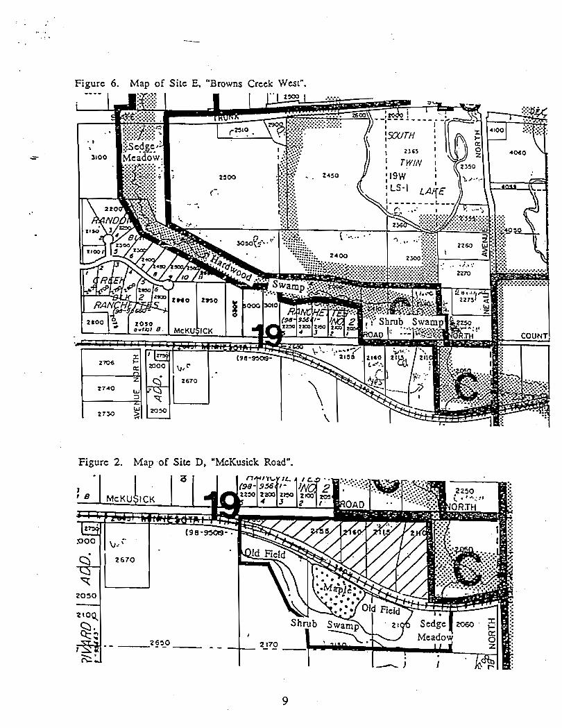
Figure 6. Map of Site E, "Browns Creek West".
Figure 2. Map of Site D, "McKusick Road".
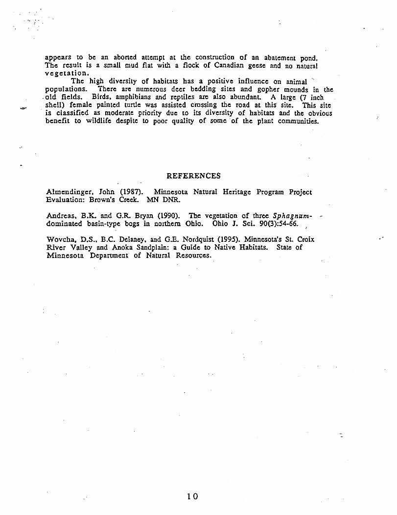
appears to be an aborted attempt at the construction of an abatement pond. The result is a small mud flat with a flock of Canadian geese and no natural vegeta t ion.
The high diversity of habitats has a positive influence on animal "
populations. There are numerous deer bedding sites and gopher mounds in the .old fields. Birds, amphibians and reptiles axe also abundant. A large (7 inch
e shell) female painted turtle was assisted crossing the road at this site. This site is classified as moderate priority due to its diversity of habitats and the obvious benefit to wildlife despite to poor quality of some of the plant communities.
REFERENCES
Almendinger, John (1987). Minnesota Natural Heritage Program Project Evaluation: Brown's Creek. MN Dm.
Andreas, B.K. and G.R Bryan (1990). The vegetation of three Sphagnum- - dominated basin-type bogs in northern Ohio. Ohio J. Sci. 90(3):54-66. .
Wovcha, D.S., B.C. Delaney, and G.E. Nordquist (1995). Minnesota's St, Croix River Valley and Anoka Sandplain: a Guide to Native Habitats. State of Minnesota Department of Natural Resources.
APPENDIX TRANSCRIPTIONS OF SITE SURVEYS
A. "Long Lake West ": "Oak Savanna" (Gadient's property) - Canopy of Pin' Oak and White Oak with interrupted canopy. Oaks are mature and open grown indicating a savanna-like habitat at one time. The shrub-layer is nearly
- continuous buckthorn with occasional gray dogwood (C. racemosa) and '
hazelnut. Occasional paper birch near pot-hole ponds and Quaking Aspen on the western edge. Ground layer contains a few oak seedlings and numerous buck thorn. Lady fern is common with occasional sensitive fern in openings. Other forbs present include Tick trefoil (Desmodium glutinosum). Enchanter's
. . Nightshade (Circae quadrisulcara). Also present are grapes and Virginia creeper and some poison ivy. Old field borders are dominated by brome grass and Kentucky bluegrass. Also present are spotted knapweed, spotted St. John'swort, goldenrod and birdsfoot trefoil.
"SW shore" (Staloch's property)- The lake has extensive Nymphea ruberosa.. There is a narrow margins of cattails. The banks have boxelder on the lower edge and open grown mature/old oaks (burr and pin). There arc cultivated fields to the top of the bank. Erosion from the fields is evident. Open areas on the margin have stinging nettles and touch-me-nots. The understory comprises of buckthorn, Ribes cynosbari and elderberry. The pond at the northeastern portion of the property has a raised mound (not floating) of rushes, sedges and arrow-leaf. The pond is surrounded by. red mapIes and white oak. The ground is covered by Canada mayflower and starflower. The north western portion of the property is mixed oak. The . canopy consists of pin oak, red maple, boxelder, white oak and occasional bIack cherry. The north and east facing slopes have extensive fern cover (interrupted, lady, sensitive). The shrub layer consists of elderberry with some buckthorn.
"Jackson estates peninsula" - Nice habitat for birding. The canopy consists of oaks (red, white, pin and burr) red maple. The understory has buckthorn and Ribies cynosbari. There is wild indigo at the bench on the peninsula tip.
Rank = B/CP
. . D. "McKusick Rd." - The south portion of D, "McKusick Rd" is bordered on the south by a creek with a narrow band of shrub swamp. The shrub swanip .is dominated by red osier dogwood and reed canary grass. There are also sedge hummocks (Carex srricra). There is a good diversity of forbs: swamp milkweed, spotted Joe-pye weed, sensitive fern, marsh fern (Thelyptris palusrris), Jerusalem artichoke, Srachys palusrris and touch-me-nots. The east and west portions, including the high knoll are old fields with poor regeneration. There is a marked lack of native bunch grasses. I saw one bunch of big blue stem among the brome grass and Kentucky blue. The forbs are dominated by goldenrod (Solidago giganrea) with abundant spotted knapweed, wild bergamot- and flowering spurge. The ground is covered in areas by creeping charlie and wild strawberries. Between the old fields is a wooded area dominared by open grown maples (Acer saccharurn and A. saccl~arinum). There is nearly 100% regeneration of the maples in all age classes. The shrub-layer also includes some elderberry and gooseberries. Except for an amazing specimen of
Solomon's seal and a few hemp, the forbs are sparse. There are some juniper and buckthorn invading the western old field which threaten the prairie regeneration. Buckthorn seedlings are also evident in the wooded arca. The diversity of habitats has a positive influence on animal populations - there are numerous active gopher mounds, deer bedding sites and trails, birds, amphibians. reptiles. One large, -7 inch shell. female painted turtle was observed. The north side of the tracks have been completely trashed for dumping old fill and a wetlands "reclamation" project.
E. "Brown's Creek West" - The north end of the creek is a nice sedge meadow with emergent vegetation. The middle third is cultivated right up to the northern slope and the southern slope has small private residential lots also up to the slope. The creek bed at this point is narrow and of hardwood swamp circumneural seep subtype. The southern third is shrub swamp. Minor ,
influence of exotics. Heat exhaustion curtailed this visit. Rank = C
F. "Hwy 69" - driveby - didn't see much.
G. "Old Stone Bridge" - The north side of the creek is Maple-Basswood with an amazingly rich forb layer: Actea rubra and A. alba (in fruit), Caullophyllum, Trillium, Jack-in-the-pulpit, wild ginger, bloodroot and ferns (shield, lady, fragile). The canopy consists of basswood and boxelder. The shrub-layer contains a distressing amount of buckthorn and some prickly ash, but it has not negatively affected the forb layer yet. Abundant and healthy poison ivy indicates foot-traffic disturbance. This is a beautiful site. Repeat visit for photos.
Rank = B
H. "Brick pond" - There is a hardwood swamp on the S.E. side of the property. Boxelder dominates the canopy. Shrubs include Japanese honeysuckle, elderberry, gray dogwood and buckthorn. Forbs are sparse. The wetlands along the creek are nearly 100% reed canary grass with some rushes. There is a stand of slender willow invading the S.E. portion. Brick pond is lined with cattails and has some duckweed. There are some mature red oak on the upper slopes. There appears to be fair regeneration in the ground layer but heavy deer browse may affect the middle age classes. Deer signs are plentiful and also some possible fox dens.
R a n k = D
I. "Holcornb additionw- Site I is a small ravine remnant. There is no evidence of water flow, though the ground is well saturated. The sparse herb layer consists primarily of Jack-in-the-pulpit, violets, creeping charlie, occasional patches of lily-of-the-valley and daylillies at the western edge. The shrub- layer consists of gooseberries (Ribes cynosbati and R. hirtellum) and elderberry. The canopy of green ash, elm and boxelder is continuous. There is a black locust located in the west central portion. This site has evidence of a high level of disturbance. Dumping is a problem at this site- yard wastes, compost, wheel rims, broken glass, plastic bags ... Buckthorn is not a common -
understory shrub but there is evidence of numerous seedlings with will be a problem in the near future.
Rank = F
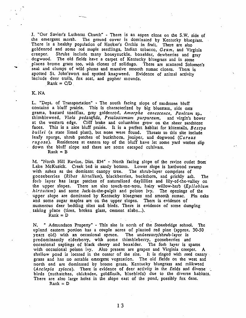
J. "Our Savior's Lutheran Church" - There is an aspen clone on the S.W. side of the emergent marsh. Thc ground cover is dominated by Kentucky bluegrass. There is a healthy population of Hooker's Orchis in fruit. There are also goldenrod and some rcd maple seedlings, Lndian tobacco, Geum, and Virginia creeper. Shrubs include many honeysuckle, boxelder, dewberries and gray dogwood. The old fields have a carpet of Kentucky bluegrass and in some
= places brome grass too, with clones of solidago. There are scattered Solomon's seal and ciumps of wild plums and massive smooth sumac clones. There is spotted St. John'swort and spotted knapweed. Evidence of animal activity include deer trails, fox scat, and gopher mounds.
Rank = C/D
L. "Dept. of TransporLationW - The south facing slope of sandstone bluff contains a bluff prairie. This is characterized by big bluestem, side oats grama, bastard toadflax, gray goldenrod, Amorpha canescence, Panicum sp., thimbleweed, Viola pedatajida, Peralostemum purpureum, and virgin's bower a t the western edge. Cliff brake and columbine grow on the shecr sandstone faces. This is a nice bluff prairie. It is a perfect habitat for kittentails, Bessya bu l l e i (a state listed plant), but none were found. Threats to this site include leafy spurge, shrub patches of buckthorn, juniper, and dogwood (Cornus rugosa) . Residences at eastern top of the bluff have let some yard wasies slip
. down the bluff slope and there are some escaped cultivars. Rank = B
M. "North Hill Ravine, Dist. 834" - North facing slope of the ravine outlet from Lake McKusick. Creek bed is sandy bottom. Lower slope is hardwood swamp with ashes as the dominant canopy tree. The shnrb-layer comprises of gooseberries (Ribes hirrellum), blackberries, buckthorn, and prickly ash. The forb layer has large patches of naturalized daylillies and lily-of-the-valley on the upper slopes. There are aIso touch-me-no&, hairy willow-hcrb (Epilobium h i r su tum) and some Jack-in-the-pulpit and poison ivy. The openings of the upper slope are dominated by Kentucky bluegrass and smooth sumac. Pin oaks and some sugar maples are on the upper slopes. There is evidence of numerous deer bedding sites and birds, There is evidence of some dumping taking place (tires, broken glass, cement slabs...).
Rank = D
N. " Admundson Property" - This site is north of the Stonebridgc school. The upland eastern portion has a couple acres of planted red pine (approx. 30-50 years old) with an occasional spruce. The understory/shrub-layer is predominantly elderberry, with some thimbleberry, gooseberries and occasional saplings of black cheny and boxelder. The forb layer is sparse with occasional poison ivy. Also present are grapes and Virginia creeper. A shaIIow pond is located in the center of the sitc. It is ringed with reed canary grass and has no notable emergent vegetation. The old fields on the west and north end are dominated by brome grass. Kentucky bluegrass and milkweed (Asclepia syiaca). There is evidence of deer activity in the fields and diverse --
birds (nuthatches, chickadee, goldfinch, bluebirds) due to the diverse habitats. There are also large holes in the slope east of the pond. possibly fox dens.
Rank = D
0. " Jaycee Ball Fieldsw - The emergent marsh dominates the north c~ntral and northwestern portion of the site. Cattails provide nearly 100% cover except for open areas of water which are edged with abundant Decodon verticillarus (EOR) and some swamp milkweed. The open water has duckweed and common bladdenvort-(in flower). Care should. be taken when dealing with the hydrology of this site. The prairie on the knoll east of the emergent march includes big bluestem and little bluestem with some Kentucky bluegrass. The forbs include goldenrod (Solidago alrissima) and whorled milkwort, bastard toadflax and culver's root. Smooth sumac and dogwood are invading. The green herons are very active.
Rank = B (EOR = A)
P. " Cooper's Additionw - Driveby: The emergent marsh is dominated by cattails with some duckweed and large leafed dock. The residents have mounted wood duck houses. Are these active? The emergent marsh is surrounded by hardwood swamp of boxelder and quaking aspen.
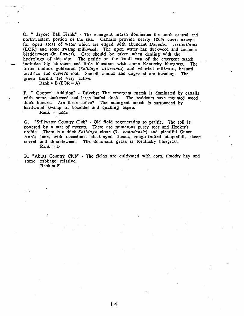
Rank = none
Q. "Stillwater Country Club" - Old field regenerating to prairie. The soil is ' covered by a mat of mosses. There arc numerous pussy toes and Hooker's orchis. There is a ihick Solidago clone (St canadensis) and plentiful Queen Ann's lace, with occasional black-eyed Susan, rough-fruited cinquefoil,.. sheep sorrel and thimbleweed. The dominant grass is Kentucky bluegrass.
Rank = D
R, "Abuts Country Club" - The fields are cultivated with corn, timothy hay and some cabbage relative.
Rank = F

In Re: The Orderly Annexation Agreement Between the City and Town of Stillwater
Effective August 16, 1996
THE AREA DESIGNATED AS N NEED OF ORDERLY ANNEXATION
Beginning at a point where the centerline of 62nd Street North (formerly the Long Lake Road)
intersects the Westerly right-of-way line of C.S.A.H. No. 5 (formerly the Stillwater St. Paul Road);
thence South along the Westerly right-of-way line of C.S.A.H. No. 5 to the South line of the Southeast
Quarter of Section 3 1, T30, R20; thence West along the South line of Sections 32 and 3 1, T30, R20 to
the Southwest comer of Section 31, T30, R20; thence North along the West line of Sections 3 1, 30 and
19, T30, R20 (which line is the centerline of C.S .A.H. 15 also known as Manning Avenue North) to the
Northwest comer of Section 19, T30, R20 (a point in the centerline of State Highway 95 also known as
Dellwood Road North); thence East along the centerline of State Highway 95 to a point where the West
line of Lot 1, Block One, Oak Glen 10th Addition extended to the North intersects the centerline on State
Highway 95; thence South along the East line of Block 1, Oak Glen 10th Addition to the Northeasterly
comer of Lot 13, Block 1, Oak Glen 8th Addition; thence west along the North line of Lots 13, 11, and
10, Block One, Oak Glen 8th Addition to the Northwest comer of Lot 10, Block 1, Oak Glen 8th
Addition; thence South along the West line of Block One and Block 2, Oak Glen 8th Addition to a point
where the line intersects the North line of Lot 6 , Block 2, Oak Glen 5th Addition; thence West along the
North line of Lots 6, 5, 4, 3 ,2 , and One, Block 2, Oak Glen 5th Addition, to a point where the line as
extended to the West intersects with the West right-of-way line of Neal Avenue North; thence South along
the West right-of-way line of Neal Avenue North to a point where the Westerly right-of-way of Neal
Avenue North is intersected by a Westerly extension of the North line of Lot 1, Block One, Trolley Trail
Acres; thence East along the North lines of Block One, Trolley Trail Acres and Valley High Estates to
the Northeast comer of Block One, Valley High Estates; thence South along the Easterly line of Block
1
One, Valley High Estates to a point where the East line is intersected by the Southwest comer of Outlot
X, Oak Glen; thence Southeasterly along the Southwesterly lines of Outlot X, Oak Glen and Lot 1, Block
1, Oak Glen 4th Addition to a point where the line is intersected by the West line of Lot 17, Block One,
Wild Pine 4th Addition; thence South along the West line of Block One Wild Pines 4th Addition and
Outlot A, Wildwood Fifth Addition to the centerline of Boutwell Road North; thence Southeasterly along
the centerline of Boutwell Road North the North line of Lot One, Block One, Pine Hill Estates extended
Easterly; thence West along the North line and South along the West line of Block One, Pine Hill Estates
to the South right-of-way line of C.S.A.H. No. 12; thence West along the South right-of-way line of
C.S.A.H. No. 12 to a point in the East half of the East Half of the Northeast Quarter of Section 30, T30,
R20, where the South right-of-way line is intersected by the following described line: beginning at the
Southwest comer of the East Half of the East Half; thence on an assumed bearing North 89" 03 minutes
06 seconds East along the South line of the East half a distance of 185 feet; thence North 2" 40 minutes
East 100 feet; thence North 21" 40 minutes East 90 feet; thence North 49" 40 minutes West to the South
right-of-way line of C.S.A.H. No. 12 (which is the point of intersection); thence continuing along the
bearing North 49" 40 minutes West a distance of 200 feet; thence North 30" 10 minutes West to the
North line of C.S.A.H. No. 12 to a point intersected by the East line of the East 80 feet of the East half
of the East Half of the Northeast Quarter of Section 30, T30, R20; thence North along the East line of
the West 80 feet a distance of 720 feet; thence West a distance of 80 feet to the West line of the East Half
of the East half of the Northeast Quarter; thence North along the East line to a point 1410.25 North of
the South line of Northeast comer of Sec. 30, T30, R20; thence West a distance of 70 feet to a point on
the east line of Lot 5, Block Two, Boutwell Valley Estates; thence South along the East line of Block
Two, Boutwell Valley Estates as extended to the North right-of-way line of C.S.A.H. No. 12; thence
West to a point where the North line of C.S.A.H. No. 12 intersects the following described line:
beginning at the Southeast comer of the West half of the East half of the Northeast Quarter of Section
30, thence West along the South line a distance of 425 feet; thence North 30" 00 minutes East 240 feet;
thence North 60" 40 minutes East 175 feet; thence North 43" 40 minutes to the North right-of-way line
(which is the point of intersection); thence South and West along the line just described to a point on the
South line of the Northeast Quarter that is 425 feet East of the Southeast comer thereof; thence East along
the South line of the North Half of Section 30, T30, R20 to the Northwesterly comer of Outlot B,
Croixwood 7th Addition; thence Southwesterly along the Westerly line of Outlot B, as extended to a point
where this line intersects an Easterly extension of the North line of Cochrane's Long Lake Addition;
thence West along the North line of this addition to the centerline of Mid Oaks Avenue North; thence
Southwesterly along the centerline of Mid 6aks Avenue North to a point where the centerline intersects
a Northerly extension of the West line of Lot 8, Block One, Cochrane's Long Lake Addition; thence
South along the West line of Lot 8 to the South line of Section 30, T30, R20; thence West along the
South line to the West line of the East half of the North half of Section 31, T30,R20; thence South along
the West line to the South line of the North half of Section 31; thence East along the South line of the
North Half (this line also being the North line of Long Lake Estates, and Long Lake Estates Second
Addition) to the Westerly right-of-way line of C.S.A.H. No. 5; thence Southwesterly along the Westerly
line of C.S.A.H. No. 5 to a point intersected by a line described as follows: beginning 130.90 feet South
of the Northeast comer of the Southeast Quarter of the Southeast Quarter (SE 114 of SE 1/4); thence
North 82" 58 minutes West 1337.70 feet to a point 33 feet North of the Northwest comer of the
Southeast Quarter of the Southeast Quarter (SE 114 of SE 114) of Section 3 1; thence Northwesterly along
the line just described until this line intersects the North line of the SE 114 of the SE 114 of Section 3 1;
thence South and parallel to the West line of the Quarter Section to the centerline of 62nd Street North
(formerly known as the Long Lake Road); thence Southeasterly along the centerline of this road to the
Westerly right-of-way line of C.S.A.H. No. 5, the point of beginning.
and
That part of the East half of Section 20, T30, R20 lying Easterly of the centerline of C.S.A.H.
No. 5 (also known as Stone Bridge Trail North), that lies South of the Northerly right-of-way line of the
Minnesota Zephyr Railroad right-of-way;
and
That part of the West Half of Section 21, T30, 3320 described as follows: beginning at a point
where the centerline of C.S.A.H. No. 5 intersects the North line of Cooper's Addition extended to the
West; thence East along the North line of Cooper's Addition to the East line of Minnesota Street extended
to the North; thence North along the East line of Owens Street as extended to the North line of the South
Half of Section 21; thence East along the Nbrth line to a point 361.25 feet West of the East line of the
Southwest Quarter of the Northwest Quarter (SW 114 of N W 114); thence North along a line extended
Northerly from that point to the Northerly right-of-way line of the Minnesota Zephyr Railroad right-of-
way; thence West along the North right-of-way line to the West line of Section 21, T30, R20; thence
South along the West line to the centerline of C.S.A.H. No. 5; thence Southeasterly along the centerline
to the point of beginning.
and
That part of the Southwest Quarter of the Northeast Quarter (SW 114 o NE 114) of Section
Twenty (20). in Township Thirty (30) North of Range Twenty (20) West, Washington County,
Minnesota, described as follows:
Commencing at a point on C.S.A.H. No. 5 centerline where the centerline is intersected by the
North right-of-way line of the Minnesota Zephyr Railroad Tracks; thence South along the
centerline of C.S.A.H. No. 5 to the intersection with an Easterly extension of the North line of
Lot 4, Block One, Oak Glen; thence West along the North line of Block One, Oak Glen to a
point 170 feet West of the West right-of-way line of C.S.A.H. No. 5; thence North 28 degrees
31 minutes 20 seconds West to the North right-of-way line of the Minnesota Zephyr Railroad
Tracks; thence East along the North right-of-way line to the centerline of C.S.A.H. No. 5 which
is the point of beginning.
The area designated as "In Need of Orderly Annexation Area" is 1190 acres.

In Re: The Orderly Annexation Agreement Between the City and Town of Stillwater
Effective August 16, 1996
PHASE I.
Beginning at a point where the centerline of 62nd Street North (formerly the Long Lake Road)
intersects the Westerly right-of-way line of C.S.A.H. No. 5 (formerly the Stillwater St. Paul Road);
thence South along the Westerly right-of-way line of C.S.A.H. No. 5 to the South line of the Southeast
Quarter of Section 31, T30, R20; thence West along the South line of Sections 32 and 31, T30, R20 to
the Southwest corner of Section 31, T30, R20; thence North along the West line of Sections 31 and 30
(which line is the centerline of C.S.A.H. 15:also known as Manning Avenue North) the North right-of-
way line of C.S.A.H. No. 12 (also known as 75th Street North), then East along the North right-of-way
line to a point where the North line of C.S.A.H. No. 12 intersects the following described line: beginning
at the Southeast comer of the West half of the East half of the Northeast Quarter of Section 30, thence
West along the South line a distance of 425 feet; thence North 30" 00 minutes East 240 feet; thence
North 60" 40 minutes East 175 feet; thence North 43" 40 minutes to the North right-of-way line (which
is the point of intersection); thence South and West along the line just described to a point on the South
line of the Northeast Quarter that is 425 feet East of the Southeast corner thereof; thence East along the
South line of the North Half of Section 30, T30, R20 to the Northwesterly comer of Outlot B, Croixwood
7th Addition; thence Southwesterly along the Westerly line of Outlot B, as extended to a point where this
line intersects an Easterly extension of the North line of Cochrane's Long Lake Addition; thence West
along the North line of this addition to the centerline of Mid Oaks Avenue North; thence Southwesterly
along the centerline of Mid Oaks Avenue North to a point where the centerline intersects a Northerly
extension of the West line of Lot 8, Block One, Cochrane's Long Lake Addition; thence South along the
West line of Lot 8 to the South line of Section 30, T30, R20; thence West along the South line to the
West line of the East half of the North half of Section 31, T30,R20; thence South along the West line
to the South line of the North half of Section 3 1; thence East along the South line of the North Half (this
line also being the North line of Long Lake Estates, and Long Lake Estates Second Addition) to the .. Westerly right-of-way line of C.S.A.H. No. 5; thence Southwesterly along the Westerly line of C.S.A.H.
No. 5 to a point intersected by a line described as follows: beginning 130.90 feet South of the Northeast
corner of the Southeast Quarter of the Southeast Quarter (SE 114 of SE 114); thence North 82" 58
minutes West 1337.70 feet to a point 33 feet North of the Northwest comer of the Southeast Quarter of
the Southeast Quarter (SE 114 of SE 114) of Section 3 1; thence Northwesterly along the line just described
until this line intersects the North line of the Se 114 of the SE 114 of Section 3 1; thence South and parallel
to the West line of the Quarter Section to h e centerline of 62nd Street North (formerly known as the
Long Lake Road); thence Southeasterly along the centerline of this road to the Westerly right-of-way line
of C.S.A.H. No. 5, the point of beginning;
and
That part of the East half of Section 20, T30, R20 lying Easterly of the centerline of C.S.A.H.
No. 5 (also known as Stone Bridge Trail North), and South of the Northerly right-of-way line of the
Minnesota Transportation Museum Railroad Tracks;
and
That part of the West Half of Section 21, T30, R20 described as follows: beginning at a point
where the centerline of C.S.A.H. No. 5 intersects the North line of Cooper's Addition extended to the
West; thence East along the North line of Cooper's Addition to the East line of Minnesota Street extended
to the North; thence North along the East line of Owens Street as extended to the North line of the South
Half of Section 21; thence East along the North line to a point 361.25 feet West of the East line of the
Southwest Quarter of the Northwest Quarter (SW 114 of NW 114); thence North along a line extended
Northerly from that point to the Northerly right-of-way line of the Minnesota Zephyr Railroad right-of-
way; thence West along the North right-of-way line to the West line of Section 21, T30, R20; thence
South along the West line to the centerline of C.S .A.H. No. 5; thence Southeasterly along the centerline
to the point of beginning.
Except for the following described property:
a. The Bergrnan Farm. 1205 - 60th Street Noah Parcel Numbers 3 1-030-20-32-0001 and 3 1-030-20-34-0001 Owners: Alvin and Helen Bergman
Described as: The Southeast Quarter of the Southwest Quarter (SE 114 of SW 114) of Section 31, T30, R20 and the West half of the Southwest Quarter (W 112 of SW 114) of Section 3 1, T30, R20 West.
b. 1223 - 62nd Street North Parcel Number 3 1-030-20-34-0002 Owner: Paul Bergman .
Described as: The East Two hundred seventy (270) feet of the Southwest Quarter of the Southwest Qua-rter (SW 114 of SW 114) and the West three hundred Thxty (330) feet of the Southeast Quarter of the Southwest Quarter (SE 114 of SW 114) lying North of a line parallel to and Seven Hundred (700) feet North of the South line of Section Thirty-one (31), Township Thirty (30) North, Range Twenty (20) West, Stillwater Township, Washington County.
c. 7143 Manning Avenue Parcel Number 30-030-20-33-0001 Owners: Robert M. and Ann S. Jordan
Described as: All that part of the Southwest Quarter of the Southwest Quarter, Section 30, Township 30 North, Range 20 West of the 4th Principal Meridian, described as follows: Commencing at the southwest comer of said Section 30; thence North 00 degrees 46 minutes 51 seconds West, grid bearing, Minnesota State Coordinate system, Southern zone, (recorded as N 00'37 00" E) along the west line of said Southwest Quarter of the Southwest Quarter, a distance of 390.00 feet; thence South 89 degrees 31 minutes 26 seconds East, (recorded as S 88O07'32" E) a distance of 60.00 feet; thence North 18 degrees 02 minutes 04 seconds East, (recorded as N 19"25'28" E) a distance of 160.00 feet to the point of beginning of the parcel to be described; thence North 73 degrees 41 minutes 36 seconds West, (recorded as N 72' 17'42" W) a distance of 210.30 feet; thence North 59 degrees 16 minutes 08 seconds West, (recorded as N 57°52'10" W) a distance of 277.77 feet to the west line of said Section 30; thence North 00 degrees 46 minutes 54 seconds West, along said west line, a distance of 310.43 feet; thence North 89 degrees 13 minutes 06 seconds East, a distance of 550.88 feet; thence South 11 degrees 32 minutes 29 seconds West, a distance of 529.72 feet to the point of beginning.
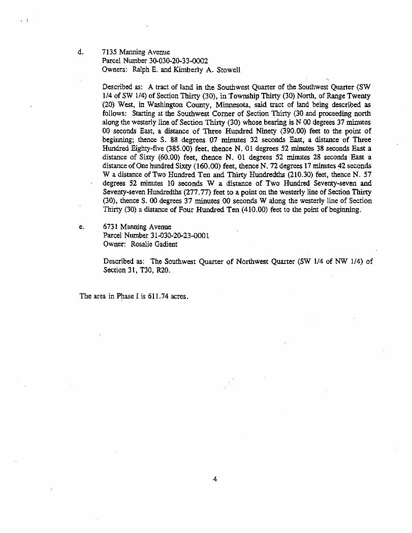
d. 7 135 Manning Avenue Parcel Number 30-030-20-33-0002 Owners: Ralph E. and Kimberly A. Stowell
Described as: A tract of land in the Southwest Quarter of the Southwest Quarter (SW 114 of SW 114) of Section Thirty (30), in Township Thirty (30) North, of Range Twenty (20) West, in Washington County, Minnesota, said tract of land being described as follows: Starting at the Southwest Comer of Section Thirty (30 and proceeding north along the westerly line of Section T h . (30) whose bearing is N 00 degrees 37 minutes 00 seconds East, a distance of Three Hundred Ninety (390.00) feet to the point of beginning; thence S. 88 degrees 07 minutes 32 seconds East, a distance of Three Hundred Eighty-five (385.00) feet, thence N. 01 degrees 52 minutes 38 seconds East a distance of Sixty (60.00) feet, thence N. 01 degrees 52 minutes 28 seconds East a distance of One hundred Sixty (160.00) feet, thence N. 72 degrees 17 minutes 42 seconds W a distance of Two Hundred Ten and Thirty Hundredths (210.30) feet, thence N. 57
- degrees 52 minutes 10 seconds W a distance of Two Hundred Seventy-seven and Seventy-seven Hundredths (277.77) feet to a point on the westerly line of Section Thirty (30), thence S. 00 degrees 37 minutes 00 seconds W along the westerly line of Section Thirty (30) a distance of Four Hundred Ten (410.00) feet to the point of beginning.
e. 673 1 Manning Avenue Parcel Number 3 1-030-20-23-000 1 Owner: Rosalie Gadient
Described as: The Southwest Quarter of Northwest Quarter (SW 114 of NW 114) of Section 3 1, T30, R20.
The area in Phase I is 61 1.74 acres.